
two places, one experience a trail plan for flynt park & keep homestead museum P re P ared for : T he r e P lan T ing M onson T ree C o MM i TT ee M onson , M assa C huse TT s s . M ari C ela e s C obar | a da M s T ou M en T he C onway s C hool s P ring 2023
Thank you to the residents of the Town of Monson and the valuable members of the core team including representatives from the Replanting Tree Committee, Flynt Park, Monson Chestnut Project, and the Keep Homestead Museum.
Thank you to all the staff at the Conway School for their never ending support and dedication.
Table of Contents


Two Places, One Experience a trail plan for flynt park and keep homestead museum T able of C on T en T s s. maricela escobar adam stoumen spring 2023 2/25 88 Village Hill Rd. Northampton, MA 01060 413-369-4044 www.csld.edu Not for construction. Part of a student project and not based on a legal survey. Project Overview & Goals Project Stakeholders Context Existing Conditions Geology & Soils Vegetation Hydrology Slopes Legal Constraints User Experience Character Zones Trail Character
Simple Trail Alignment Trailhead Analysis Trailhead Design I Trailhead Design II All-Persons Trail Design Design Spotlight: Wetland Area Trails Design Spotlight: Forest Trail & Mt. Top Trail All-Persons Trail Guidelines Design Details Preliminary Cost Estimates Works Cited & Resources a nalysis d esign 3 4 5 6 7 8 9 10 11 12 13 14 15 16 17 18 19 20 21 22 23 24 25
Project Overview & Goals
In 2011, a tornado touched down in Monson, MA. It's disturbance shifted the tree canopy caused human use and natural communities to adapt to the new environment.
f ollowing d es T ru CT ion , a P ar T nershi P f or M s
Two adjacent town-owned properties in Monson, Massachusetts, Flynt Park and Keep Homestead Museum are at a glance separate entities with different user groups, activities, missions, and programming. However, since nature knows no political boundaries, in June of 2011 a tornado ripped through Monson and the surrounding area, impacting the tree canopy heavily on both properties.
2010
Prior to the tornado, apart from ballfields and hayfields, a dense, second-growth, mixed hardwood forest canopy covered the both properties.


2011
What was once a dense forest became open and exposed. After the tornado moved through the properties, thousands of fallen trees lay on the ground. The most disturbed area runs east to west through the center of the site.
2015
In the following years, the state and federal government brought heavy machinery through the site to salvage the timber that had fallen. The legacy of those logging roads has continued as they have been kept open by use as trails and access for maintenance equipment. A shift in the canopy structure also allowed for new ways to use both properties. At Flynt Park, a disc golf course and a picnic overlook were created. At Keep Homestead Mueseum, more nature trails were developed.
Present Day
The most disturbed areas are now filled with early successional plant species. Trails, both purposely built and from the former logging roads weave through the variety of forest types and canopy coverage leftover from the tornado.

Into the Future
A decade or so after the tornado, in the winter of 2022, stakeholders and users from both places came together through a Town committee to think about how the two town-owned properties could together become a better asset for Monson residents. Located just over a mile from the town center and with dramatic slopes with views of the Chicopee Brook valley, the combined parcels have the elements to be a hub for both passive and active recreation. The Town hopes to one day create a master plan for the almost 200 acres of fields, forests, and meadows so that all interest groups are included in the decision making process. Since the trails are a feature both properties share and have seen plenty of disturbance, members from all parties agreed that the best place to start would be a trail plan.
g oals and o bje CT ives
Connect Flynt Park with the adjacent Keep Homestead Museum
• Realign the current trails into a system that crosses property lines and joins both properties into one unified landscape

• Create an inviting experience at the trailheads at both properties

Increase the level of accessibility on site
• Design a trail that fits within the U.S Forest Service Trail Accessibility Guidelines that connects the properties
• Redesign trails to provide a range of difficulty levels
• Separate walking trails from other forms of recreation
Improve wayfinding for a diversity of user groups
• Establish consistency in elements like blazing, trail surfaces and signs throughout the landscape
• Increase trail legibility
Celebrate the destinations and historical land use
• Align paths with points of interest
• Provide more information along the trails and at the trailheads

s. maricela escobar adam stoumen Spring 2023 3/25 88 Village Hill Rd.Northampton, MA 01060 413-369-4044 www.csld.edu Not for construction. Part of a student project and not based on a legal survey. Two Places, One Experience a trail plan for flynt park and keep homestead museum P roje CT o verview & g oals
flynt
keep
flynt
keep
flynt
keep
museum flynt
keep
museum
2010: P rior T o T ornado 2011: af T er T ornado 2015: T i M ber salvage 2022: regrow T h
park
homestead museum
park
homestead museum
park
homestead
park
homestead
Project Stakeholders
Flynt Park Keep Homestead Museum
• Used mainly for sports
• Trails were created by timer salvage, continued use, and interest groups
• Main user group: younger families, students, athletes
• Trails
• Site specific history
• Forest
• Views
• Used mainly for walking, gardening, special events
• Trails were created with access in mind
• Main user group: older folks, hikers, gardeners

As publicly owned, accessed, and managed properties, the stakeholders of this project are primarily the residents of the Town of Monson.
r e P lan T ing M onson T ree C o MM i TT ee
The natural disturbance caused by the 2011 tornado that ripped through Monson destroyed properties, lives, and trees, initiating change within the community and the forest. Residents of Monson who realized the multitude of benefits that trees offer formed the Replanting Monson Tree Committee.

Their work seeks to:
• Replant public trees for people to enjoy their beauty, shade, and life for generations to come
• Assist Monson homeowners through the provision of tree care information and trees


• Leverage national, state and local resources in support of the committee's vision
• Unite the community through events to share in the Replanting
• Entrust the trees' care to future generations

After reaching their goals of replanting nearly 900 trees around Monson, they are seeking other ways to encourage the connection between residents and trees.
T he K ee P h o M es T ead M useu M
Led by a board including two former students of the Museum's visionary, Myra Moulton (a descendant of the Keep Family), the Keep Homestead Museum is a community destination in Monson. The house and land were willed to the Town by Moulton with the stipulation that the home would showcase her beloved and vast collection of buttons and family artifacts. With American chestnut floorboards and steps and sidewalks made out of granite, most likely from the quarry on the property, the place hearkens back to the colonial and industrial time periods.
The programming of the Museum and its grounds includes special events, an open houses on the first Sundays of the month (April-December), art exhibits, a community garden, and walking trails through the property. Given the shared interest of this project, the Keep Homestead Museum board and community are important stakeholders as they are a main user group of the trails and active members of the community.
M onson C hes T nu T P roje CT
With a large disturbance comes new opportunity. A hint of the past was uncovered by the wake of the tornado. Once the forest started to regrow following the tornado, flowering American chestnut trees were found at Flynt Park. Taken out by a blight, the once abundant North American tree species is rarely seen in its mature form as the blight kills chestnut trees before they can reproduce successfully. This sparked a local teacher and student group to begin the Tantasqua Chestnut Project. Later, in collaboration with the Replanting Monson Tree Committee, the Monson Chestnut Project was added and today the dual projects are known as the Tantasqua/Monson Chestnut Project. Atop Mt. Ella, the highest point at Flynt Park, the project uses blight resistant, hybridized seeds and saplings, funding from Monson's Community Preservation Fund and other local sources, and support from the American Chestnut Foundation to experiment with regrowing the species on 5 acres.
M onson P ar K and r e C rea T ion d e P ar TM en T
The Monson Parks & Recreation Department staff are key stakeholders as Flynt Park is under their management. With a team of three, Flynt Park is one of a handful of parks and facilities that falls within their jurisdiction. In recent years, they have led the park through major improvements including drainage installation following the tornado, the addition of a playground, and the installation of a disc golf course. The "Mountainside" disc golf course has been ranked as one of the best free-to-play courses in the state and hosts tournaments. The ability to embrace such a fast-growing sport and provide a quality course is emblematic of the Park and Recreation Department's commitment to their mission:
"...To enrich and enhance the quality of life by offering a high-quality diversified program of sports and recreational activities."
Their impact is far-reaching and their role as managers and administers of programming plays a key role in shaping the lives of residents of Monson. These programs are designed to encourage health, fitness and learning for all ages and abilities.
s. maricela escobar adam stoumen Spring 2023 4/25 88 Village Hill Rd.Northampton, MA 01060 413-369-4044 www.csld.edu Not for construction. Part of a student project and not based on a legal survey. Two Places, One Experience a trail plan for flynt park and keep homestead museum
P roje CT s T a K eholders
A system of signs
Updated trail maps
Formal outdoor gathering areas
A trail at Flynt Park winds through the early successional growth left over by the 2011 tornado. Some trails lead to the Keep Homestead and others intersect with the Chestnut Project's trial plots.
Flynt Park and Keep Homestead Museum have been continuously impacted by human use for thousands of years however colonial and industrial histories are most obviously present on the landscape today. The significance of largely forested public land amongst residentially and commercially densely developed areas should not be overlooked. Enhancing nature trails at the site would have a positive impact on the community's ability to get outside.
y - s ha P ed v alley
The region of central Massachusetts was shaped largely by north/ south glacial activity which created river valleys and shaped rolling hills. When the glaciers receded, native peoples started to inhabit the landscape. Concentrating mainly along river valleys, more rugged topography, like the type at Flynt Park and Keep Homestead, was used for seasonal hunting and travel. More dense settlements and activity was most likely on the northern border of present-day Monson, where the Chicopee brook meets the Quabog river.

Flynt Park and Keep Homestead occupy land within the ancestral homelands of the Agawam and Nipmuc peoples. The white star indicates where the present-day project site is located amongst the estimated territories of these tribes near the time of European arrival. The first record of the Keep homestead property being "owned" by non-native people was around 1733. From then on, more abutting acres were bought and the home that is currently on site was built around 1800.

C en T rally l o C a T ed , l i M i T ed a CC essed
Flynt Park and Keep Homestead sit within both rural residential and residential village zoning classifications though both properties are protected from development. Within a one mile radius, there are 1,729 structures. Within a two mile radius, there are 1,521 structures. According to the 2020 census, Monson's total population is 8,150. If structures, in this case mostly homes, can be used to estimate population density, it is safe to say that the site is within a relatively populated densely area for Monson. This means that the project site is a close distance to the majority of Monson residents and within walking distance (a mile) to a fair amount. However, with only two access points on east side of the site, only a fraction of those people can enter the site easily. Within the scope of this project, expanding accessibility to the site means creating trails through natural areas that people of all abilities can enjoy.
a n eighborhood f ores T
The site sits in a mostly forested landscape among residential lots. On the west it is bordered by Paradise Lake, a privately owned pond with spacious residential lots along its edge. On the northwest, it is bordered by a wetland and a town-owned and operated cemetery. Private land that was recently logged abuts the northern border while more dense residential development lies to the northeast. Directly to the east is the town center of Monson hosting a variety of commercial developments like restaurants, store fronts, and offices. To the east of the main strip, are other town parks like Cushman's field and Veteran's field. These two fields serve as mainly sports fields though they do host occasional events and a skate park.
The areas to the east of the site are more developed and close to roadways, connecting them to residential neighborhoods and commercial activity. The areas bordering the site in every other direction are largely forested and therefore not as used. Having two site access points on the east partially limits the ability for residents to experience all of Flynt Park and Keep Homestead and its grounds. At the same time, having only two points of entry might make it easier to regulate the type of use and behavior on the landscape.

s. maricela escobar adam stoumen Spring 2023 5/25 88 Village Hill Rd.Northampton, MA 01060 413-369-4044 www.csld.edu Not for construction. Part of a student project and not based on a legal survey. Two Places, One Experience a trail plan for flynt park and keep homestead museum
C on T ex T
Context
Nativeland.ca shows that Monson is located on land historically inhabited and stewarded by the Agawam and Nipmuc peoples.
The Town's zoning map and the amount of structures within a two-mile distance of the site indicates it is well-situated to accommodate most Monson residents.
Flynt Park and Keep Homestead Museum are bordered by a variety of landed uses but mostly forested land cover.
monson
Existing Conditions
The project site (~221 acres) including Flynt Park and Keep Homestead varies in condition, use, and character. Most of the western acreage is not frequently used and remains quite remote. The eastern half, which connects to bordering roads of Park Road and Ely Road, contains the actively used zones.


f lyn T P ar K
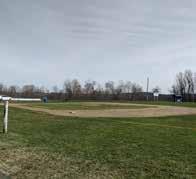
A driveway starts at Park Rd. and continues in between two soccer fields set in front of the steep, forested, easterly slope of Mt. Ella. Midway up the driveway a gravel parking lot, bleachers, a kiosk, and a tee box face north towards the tree-line. This serves as the starting point to Mountainside Disc Golf, an 18-hole, 28-acre, wooded course that guides players through the northern part of the property and up to the peak of Mt. Ella at around 825 feet. Farther south along the driveway, a ball field is set in the foreground with a view of the Chicopee Brook valley. Upslope, a carriage road called “Chestnut Avenue” runs parallel to the driveway. A remnant of the road historically used by Flynt Park goers to traverse the park, picnic, and be entertained by a zoo that ran along the side of it. At the end of the driveway, a third ball field dominates the view to the south as the concrete widens to a larger parking lot. Adjacent to the parking lot sits a children's playground with a view of the northern ballfields. To the west, about equal size, is a parking lot with a compacted sand, and gravel surface, used as overflow parking and a utility space for the Parks and Recreation crew. No running water is available at Flynt Park but there are two portable toilets. Cutting through the forested areas are disc golf trails, old carriage trails, and unmarked trails. Apart from disc golf hole numbers and tee boxes, the trails do not have consistent markings. Near the peak of Mt. Ella there is a cleared area where a picnic bench and a fire pit look out to the east.


K ee P h o M es T ead M useu M
The colonial home of the Keep Family was originally built in the mid-1700s. Willed to the Town of Monson with the stipulation of it becoming a Museum for the collection of buttons and family artifacts, this house now home to the Keep Family Homestead Museum; an organization which through the museum, events and programming, continues the legacy of the last owner, Myra Moulton. Apart from the house, this property is used and valued for a variety of different reasons. On three sides of the house, a sloping lawn hosts some seating areas and art sculptures. To the south, a barn there are three raised beds at a height designed for wheelchair use, abut a parking lot. To the south of the lot is a community garden hosting a dozen or so plots. To the south of the gardens sit three hayfields maintained by the last dairy farming family in town. To the west of the fields and into the forest lies a network of trails more intentionally designed than those at Flynt Park, but sporadically managed. An old quarry that is now a certified vernal pool, a pond, and gentle forested topography are the features and destinations that make the landscape at this property an engaging place to be.

s. maricela escobar adam stoumen Spring 2023 6/25 88 Village Hill Rd.Northampton, MA 01060 413-369-4044 www.csld.edu Not for construction. Part of a student project and not based on a legal survey. Two Places, One Experience a trail plan for flynt park and keep homestead museum e xis T ing C ondi T ions
Heavily used trails through the forest host disc golf baskets (seen in the distance).
One of three baseball and soccer fields at Flynt Park.
A playground overlooks the center ballfield and is bordered by the upper parking lot.
A picnic overlook near the peak of Mt. Ella is the prominent destination on site.
One of three hayfields that add to the character of Keep Homestead Museum.
Hiking trails across the site switch from open to closed canopy and vary in condition.
A community garden to the north of a hayfield at Keep Homestead Museum.
One of five acres of early successional forest in which the Chestnut Project has planted blight-resistant seeds & saplings.
The historic home and barn are a prominent roadside feature in Monson.
1 2 3 4 1 2 3 4 5 5 6 6 7 7 8 8 9 9
Geology & Soils


If away from exposed bedrock and on sandy soils, trails at Flynt Park and Keep Homestead could be less susceptible to erosion and pooling. However, given the disturbance history on the landscape and the level of current use, amendments and alterations to the trails must be made to give the user an enjoyable experience and promote ecological health.


g la C ially s ha P ed l ands C a P e
As the last ice age waned, the laurentide ice sheet dramatically altered the landscape across North America and in Monson. Over thousands of years, lakes formed and rivers shifted material all across the landscape. In the Monson area, around 15,000 years ago, a glacial lake later named Quaboag formed in the Monson-Palmer area. Peaks that were above 660 feet, including the top of Mt. Ella and the nearby Peaked Mountain, were perched above the water. About 12,400 years ago the water receded from Glacial Lake Quaboag to form the Chicopee River Basin, one of the largest drainage basins in the state. The valley is bordered by two prominent ridges running north and south on the east and west sides of town. Monsonʼs highest peaks, including Peaked Mountain (1,278 feet), West Hill (900 feet), and Mount Ella (820 feet) are part of the western ridgeline. Rolling hills form the eastern ridgeline that can be seen from the top of Mt. Ella.
g la C ial T ill and e x P osed b edro CK
Flynt Park and the Keep Homestead Museum and its grounds are underlain by gneiss and schist bedrock. As evident by an old quarry at the Keep Homestead Museum and the old granite foundations seen at Flynt Park, whose namesake made a fortune in the granite industry, Monson Granite was quarried at the base of the western ridge line for use in many of the town's historical buildings. The eastern ridge, in contrast, was formed by glacial deposits of schist, sandstone, feldspar, and quartz. This glacial formation occurred when the glaciers retreated several thousand years ago and dropped and stirred up debris gathered from the bedrock and distant landscapes. Areas of exposed bedrock can either be a desirable feature to a more rugged trail's surface or limit the capacity to develop more accessible trails. They can also define an experience outdoors by emphasizing features and destination points along a pathway. Exposed bedrock and large till deposits can help people appreciate the specific qualities of the natural landscape of the site, and be used as fixtures of a site’s identity.
s andy s oils
Given the gneiss bedrock and the glacial till surficial geology, the soils that formed with those natural conditions are mostly fine sandy loam. With the exception of small portions of the site, the site is mostly moderate to well draining soil that in areas, can be shallow to bedrock. Given those conditions and the topography of the site (water generally shedding off the mountain to lower areas), water moves quickly off the site with the exception of areas subject to human impact and use. Trails that are not correctly graded to have a crown or a side slope of 2 percent and with a running slope greater than 15 percent tend to erode with heavy rainfall and cause issues for users. This was exacerbated after vegetation was cleared from the tornado and soil was compacted by machinery and heavy use. As a result, water was able to move faster along the surface, but puddle in spots of compaction. Trails not graded to take water off to the side, erode at very shallow grades.
Adapting the trail system on site to fit with the goals of accessibility and connecting the two properties means assessing where the trail conditions are encouraging erosion or pooling and where it can be managed.

Two places, One experience a trail plan for flynt park and keep homestead museum s. maricela escobar adam stoumen spring 2023 7/25 88 Village Hill Rd.Northampton, MA 01060 413-369-4044 www.csld.edu Not for construction. Part of a student project and not based on a legal survey. g eology & s oils
Granite Quarries like Flynt Quarry in Monson helped drive the economy in the late 1800s and early 1900s. (Photo credit: Monson Historical Society)
Large boulders (glacial till) can be a point of interest that defines a trail experience.
A flat trail that has experienced disturbance, without a side slope, experiences puddling even during periods of dry weather.
Exposed bedrock limits the ability to manipulate trail conditions but can be a party of a pleasurably steep trail.
A de-vegetated and compacted slope from past disturbances allows for more pooling on otherwise well draining soil.
1 2 1 2
Vegetation
The 2011 tornado not only caused tree canopy loss, but led to a legacy of logging roads, and ultimately a different human relationship with the landscape.

v ege T a T ion T y P es
The majority of land cover at Flynt Park and the Keep Homestead Museum is vegetated. Prominent vegetation types include deciduous forest, early successional forest, turf grass, and farm fields.

Mature deciduous trees are found along the most northern sections of Flynt Park. On the northwest side of Flynt Park, one of the trails has a triving plant understory that includes patches of ferns, while the northeast side has a bare understory that might be resulting from a heavier disc golf course usage. The western, center, and southern areas of Flynt Park are largely covered in early successional fores. Observed early stuccessional forest species include aspen, beech, birch, cherry and maple.
Though there is a western section at the Keep Homestead that is also covered in mostly early successional forest with a similar vegetation makeup of the Flynt Park early successional forest area, a large portion is covered in mature deciduous trees with some evergreen trees. Additionally, the Keep Homestead Museum building is adjacent to farm fields on the southern and western edges that are managed by a local farmer for hay, and a small section of this land is used as public community garden.
The visitor experience through some segments of the trails is negatively impacted by early successional forest vegetation branches hanging over parts of the trails. Long patches of grassland on some of the logging road trails at Flynt Park can also limit accessibility and the comfort of visitors particularly during spring and summer months when ticks are prevalent in the area.

Establishing trails that bring people through these various vegetation types can provide a diverse trail experience for visitors. Addtionally, meeting accessibility guidelines for an all-persons trail can improve visitor experience along areas that are currently grassy or have branches that hanging over trails through removing these.
T he a M eri C an C hes T nu T and T he M onson C hes T nu T P roje CT

The American chestnut tree (Castanea dentata) was once commonly found throughout the eastern forests of the United States, and served as an important source of timber and food. However, in the early 1900s a pathogen was observed on these trees, and by the 1950s, the chestnut blight, an air-borne fungus, had decimated the great American chestnut tree. Today, some chestnut trees resprout from the blighted root systems but they do not reach full maturity.
After the 2011 tornado, a discovery of American chestnut trees at Flynt Park led to the creation of the Monson Chestnut Project with the hopes of bringing back this once mighty giant. The Monson Parks and Recreation Commission granted five acres for this project with additional assistance being provided by the Replanting Monson Tree Committee.
In collaboration with the Tantasqua Chestnut Project, the Monson Chestnut Project planted the five acres of land at Flynt Park with hybrid chestnut trees provided by The American Chestnut Foundation (TACF). In addition, the Monson Chestnut Project cross-bred native American chestnuts found at Flynt Park with blight resistant hybrid from TACF to create regionally adapted trees that are blight resistant. The intention of the project is to breed American chestnut trees that are able to compete within New England forest communities, and to attempt to bring back the American chestnut.
A new trail alignment or an all-persons trail might intersect the current areas of the Monson Chestnut Project. Educational signs can be integrated along the Monson Chestnut Project on the American chestnut tree.
Two places, One experience a trail plan for flynt park and keep homestead museum s. maricela escobar adam stoumen spring 2023 8/25 88 Village Hill Rd.Northampton, MA 01060 413-369-4044 www.csld.edu Not for construction. Part of a student project and not based on a legal survey. v ege T a T ion
Lawn 50 Ft. 0
An early successional forest area at the top of Mount Ella planted with with chestnut tree hybrids.
Brush-Hogged Field
Intermittent Brook Hayfield Garden Forest
Section A-A' The trailhead start of Keep Homestead Museum is adjacent to the community garden descending to an intermittent brook. From here it ascends on a slope greater than eight percent, through a meadow field- this portion of the trail is known as the Meadow Trail.
1 2 2 1 A A' Lawn
Deciduous trees including red and sugar maples near the start of the Christmas Fern Trail.
d rainage P a TT erns
Water on the northeastern side of Flynt Park drains to a ditch along Park Road which is directed to the Chicopee Brook. On the western side of Flynt Park, water drains to a wetland that also connects to this brook. On the southern side of Flynt Park, water drains east down the slope of Mount Ella into the Keep Homestead property. The drainage then makes its way to a wetland, and an intermittent brook that bisects the Keep Homestead Museum property from south to north. Water from the most eastern and southern parts of the Keep Homestead Museum site also drains into this wetland, and intermittent brook, which eventually flows off-site on the northeast side of the Keep Homestead Museum property. The water from this intermittent brook also flows to the Chicopee Brook.
The Chicopee Brook drains to the Quaboag River. The Quaboag River then merges with the Swift and Ware Rivers and joins the Chicopee River, which is a Connecticut River tributary. Collectively, Flynt Park and Keep Homestead Museum, along with many private and public properties, form part of the Chicopee Watershed.
Information about the hydrology of the site can help visitors better understand the connection with the Chicopee Watershed.


s P rings , v ernal P ools & w e T lands
Combined, Flynt Park and the Keep Homestead Museum have three springs, two certified vernal pools and two wetlands. The three springs are located on the norheast side of Flynt Park, and serve as a local cultural value. One certified vernal pool is near the high point of Mount Ella, and the other one is located on the southwest side of the Keep Homestead Museum. Vernal pools serve as a unique environment for certain species including wood frogs (Rana sylvatica) and fairy shrimp (Eubranchipus vernalis). Disturbances to vegetation and soils near vernal pools impact animal mortality, and habitat health. To protect the health of springs, vernal pools and wetlands, and to reduce human impact near these sites, trails need clear trail delineation, educational signs, and potentially boardwalks.
a n a T ural d isas T er h ydrology
After the 2011 tornado, Flynt Park installed three separate drainage ditches on the western sides of each of the playing fields to help mitigate their wetness. According to the Parks and Recreation Director, Timothy Pascale, the playing fields had been historically dry, but after the tornado removed an extensive portion of the tree canopy on the slopes of Mount Ella, the fields began to experience wetness. The ditches along the two northern playing fields drain to a ditch alongside Park Road that is directed to the Chicopee Brook. The ditch alongside the southern playing field drains to the south, creates pooling that slowly flows through mostly shrub vegetation, and makes its way to the intermittent brook at Keep Homestead Museum.
The tornado left behind a legacy of significant tree canopy loss and, after the salvage operation that followed, a series of logging roads. Currently, approximately 25 percent of the land cover at Flynt Park and the Keep Homestead Museum is early successional forest that resulted from the impact of the tornado. While some of the logging roads have created depressions where water shed from Mount Ella pools, others in steep areas are less water permeable due to a combination of steepness, lack of vegetation, and exposed bedrock. This is potentially contributing to a greater percentage of water that is not being absorbed on site by the younger vegetation.
Visitor use of the former logging road trails is impaired, particularly after it rains, due to water pooling on the trails. Trails through young forest areas are particularly impacted by sections of intermittent wet spots, which create an uncomfortable walking experience for visitors.

For an improved visitor experience, some wet areas along trails might need grading or boardwalks, some trails sections might need to be rerouted, and some trails might need to be closed off.

Two places, One experience a trail plan for flynt park and keep homestead museum s. maricela escobar adam stoumen spring 2023 9/25 88 Village Hill Rd.Northampton, MA 01060 413-369-4044 www.csld.edu Not for construction. Part of a student project and not based on a legal survey. h ydrology Wetland Forest Edge Forest Hayfield Museum 50 Ft. 0 Section A-A' The Keep
Homestead Museum's land cover features a decidous forest with patches of evergreen forest, a wetland pond, and pasture/hay fields adjacent to its buildings.
Areas of pooling are commonly found along the trails, even during dry spells, making portions of trails impassable, and impacting the visitor experience.
Hydrology
1 1 2 A A' 2
An intermittent stream runs from south to north on the Keep Homestead Museum property. Poorly draining depressions llike this one were left behind by heavy machinery, and are common on many of the former logging road trails, making it hard to traverse across.
Slopes

Flynt Park and the Keep Homestead Museum have very few trails that fit accessibility guidelines, limiting the number of people who can enjoy the site.

f lyn T P ar K s lo P es
The highest point in Flynt Park is the peak of Mount Ella at 827 feet above sea level and the lowest point is on the northeast corner at 522 feet above sea level. The steepest slopes at Flynt Park are located on the eastern side between the playing fields and the peak of Mount Ella. This area is dominated by slopes of over twenty percent. Access to the peak of Mount Ella and the picnic area overlook from the Flynt Park is limited to people who can manage these steep slopes. On the northeast side where a great portion of the disc golf course is located, slopes between twelve and twenty percent dominate. In general, on the western side of Flynt Park, gentler slopes of less than twelve percent, with areas of less than eight percent, are common.
Sighting an all-persons trail that connects to the picnic overlook from Flynt Park might be challenging due to the steep slopes that bisect the property.
K ee P h o M es T ead M useu M s lo P es
The steepest slopes at the Keep Homestead Museum are located in the northern section of the property, as well as adjacent to the buildings. Gentler slopes are present along the farm fields located on the south, on the western side of the property, and along the intermittent brook that runs south to north on the eastern edge of the property. Along this brook, slopes of less than twelve percent are present as well as the start of three different trails.
The farm field edges and the area surrounding the pond might be better suited for an all-persons trail. In some areas, the natural slopes will need to be altered to meet accessibility guidelines.

T rail s lo P es
The majority of the trails at both properties are above eight percent, and are not an all-persons trail. Larger trail segments at less than approximately eight percent are located on the western side of the Flynt Park, along a Flynt Park trail that connects to the Hillcrest Cemetery (a town-owned cemetery), along Flynt Park Chestnut Road Trail, and along the Christmas Fern Trail at the Keep Homestead Museum.

Though the salvage logging road operation created new trails and opened the area to more trail users, these trails are not accessible to many users due to their steepness, cross slope, some exposed bedrock, and trail depressions. On a site visit, a forty-five degree slope was documented at one of the logging road trails. Additionally, the steepness and bareness along some of these logging road trails are contributing to erosion which impacts the health of the environment.
To create an all-persons trail on site, creating new trails might be necessary. Additionally, in a new trail alignment, portions of trails might need to be rerouted, graded or closed off for improved visitor accessibility and experience, and to promote ecological health, due to erosion concerns.
Two places, One experience a trail plan for flynt park and keep homestead museum s. maricela escobar adam stoumen spring 2023 10/25 88 Village Hill Rd.Northampton, MA 01060 413-369-4044 www.csld.edu Not for construction. Part of a student project and not based on a legal survey. s lo P es
15 Ft. 0
Hayfield Sphagnum Moss Trail
Parking
Trail
The Meadow, Butternut, and Sphagnum Moss trails, all descend from the Keep Homestead Museum parking lot, and start along an intermittent brook.
Lot/ Trailhead
Trail
Museum Parking
LP 522 Intermittent Brook
1 2 1 2 A A' Trail
Steep slopes along a trail that was created by the logging salvage operation following the 2011 tornado. Section A-A' Access to the start of the Sphagnum Moss Trail from the Keep Homestead Museum requires descending through a hay field with slopes varying between twelve and twenty percent.
Picnic
overlook
HP 827
Mt. Ella
Legal Constraints
An agricultural preservation restriction (APR) on part of the property at the Keep Homestead Museum, wetlands and priority habitat of rare species on both properties may require permitting for trail development.

a gri C ul T ural l and
As part of the process of acquiring the Keep Homestead Museum property from the previous owner, Myra Moulton, the Town agreed to preserve part of the Keep Homestead Museum land as open space in perpetuity, and the other part as agricultural. The hay and meadow fields at the Keep Homestead Museum are part of an Agricultural Preservation Restriction (APR) Program which established a permanent deed restriction that preserves the land for agricultural uses. Approximately fifteen and a half acres located on the southwest side of the property are under this APR program, and part of this land is maintained as hayfields by a neighboring farmer. One of the farm fields under the APR Program, as indicated by a 2010 APR monitoring report, is brush-hogged once a year. Additionally, adjacent to the Keep Homestead Museum’s parking lot is a vibrant community garden.
Non-agricultural as well as certain agricultural uses may require a Certificate of Approval (COA) from the Massachusetts Department of Agricultural Resources (MDAR). According to MDAR:
“Changes in agricultural structures or activities require a COA. Unless otherwise stated in your APR agreement changes:
• Cannot result in impervious surfaces greater than five acres or five percent of the APR land, whichever is less, and if the APR agreement has a more stringent requirement, it will prevail

• Must minimize, to the fullest extent possible, the loss of agricultural soils
• Must not interfere with agricultural operations and will preserve, maximize, and realize the agricultural potential of the APR land, and in addition, improve future agricultural operations” (MDAR).
Though the APR agreement for the Keep Homestead Museum explicitly states that existing trails may be maintained, it does not mention the creation of new trails.
It is likely that creating an all-persons trail that starts at the Keep Homestead Museum may need a COA due to the steep slopes near the parking lot and the buildings of Keep Homestead Museum. A COA might be needed for the development of any new trails that takes land out of agricultural use, a new parking lot, the location of future new trails, trails with impervious surfaces, or for implementing an initial portion of an all-persons trail adjacent to the current parking lot.
w e T land r es T ri CT ion
At Flynt Park, a wetland sits along the western property line and another one is near the peak of Mount Ella. At the Keep Homestead Museum, a wetland is located close to the Keep Homestead Museum building. Wetlands serve as an important breeding habitat for certain wildlife including frogs and salamanders, and can also help mitigate floods and erosion by serving as catchments.
Any work done within a 100-foot buffer of a wetland would require a permit from the Town's Conservation Commission. Additionally, boardwalks and bridges might be needed for accessibility, and to mitigate human impact along these wetland environment, which would also require permits.
v ernal P ool r es T ri CT ion
A vernal pool is located near the top of Mount Ella at Flynt Park, and on an a former quarry site on the southwesern part of the Keep Homestead Museum property. Vernal pools can go unnoticed due to seasonal wetness but serve an important ecological habitat for several species.

Trail work near vernal pools may need to file a Request for Determination of Applicability with the Town of Monson Conservation Commission to see whether the vernal pools at Flynt Park and the Keep Homestead Museum receive the same protections as wetlands under the the Massachusetts Wetlands Protection Act.
P riori T y h abi T a T s of r are s P e C ies
The Massachusetts Endangered Species Act (MESA) protects rare species and their habitats, and both properties are delineated as priority habitats of rare species by the NHESP. Proposed projects and activities such as an all-persons trail requiring grading, excavating and filling on these habitats would need to file with the NHESP under the MESA for a review and approval prior to project and/or acitivity initiation. Similarly, a new trail alignment will likely require the same.
Two places, One experience a trail plan for flynt park and keep homestead museum s. maricela escobar adam stoumen spring 2023 11/25 88 Village Hill Rd.Northampton, MA 01060 413-369-4044 www.csld.edu Not for construction. Part of a student project and not based on a legal survey. l egal C ons T rain T s
Parking
Museum
The community garden and the farm fields are located on APR land, and adjacent to the current parking lot of the Keep Homestead Museum.
Parking Lot
Hayfield Trail Garden
Garden
1 2 1 2
A wetland on the Keep Homestead Museum parcel lies between a decidous forest and hayfields.
User Experience
For people visiting Flynt Park and Keep Homestead, the existence of trails is not immediately obvious. Providing visual queues and information at the parking areas could help encourage people to use the trails and experience both properties together.


a CC ess , C ir C ula T ion , v iews
Vehicle Experience
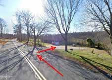
There are two main points of entry to the site. The Flynt Park entrance is off of Park Road, a dead-end street which climbs in elevation up from High Street, which connects to Main Street. Once in the park, vehicles use the driveway which goes west a few hundred yards before a gravel parking lot. This lot has a large kiosk with disc golf information and room for around 10 cars. The driveway then veers to the south another few hundred yards before dead-ending at another parking lot. Apart from the disc golf area, which is not meant for all types of users, it is not clear which parking areas is close to the trailhead. The other main entry point to the site is off of Ely Road, similarly a side street which climbs in elevation up from the connecting Main Street. Vehicles enter Keep Homestead Museum directly off the road, as there is just thirty or so feet of room between the 35 mile per hour road and the parking lot. No barriers or gateways indicate the prescribed use of the parking lot as it is shared by community gardeners, museum goers, and hikers.

Pedestrian Experience
Foot traffic follows the pattern of vehicle traffic. People tend to use areas closer to their parked cars. At Flynt Park, the disc golf course and ball fields experience heavy foot traffic. After multiple site visits and community engagement sessions in spring 2023, it is still hard to tell which trails get used the most. The trails and forested areas in between the two main vehicle entrances seem to experience significantly less foot traffic.
Views
There are six desirable views across the site. At Flynt Park, the playground overlooks the ballfield providing a quality spectating experience. Chestnut Avenue, the old carriage road, similarly provides a desirable view for spectators watching games or looking for a more elevated view. At Keep Homestead, desirable views are located at the pond and of the meadow. In higher elevations, there are three cleared areas with views of the valley. Along the trail, there are multiple opportunities for places with a cleared viewing area if the dense vegetation is cut back. The most desirable view however is close to the peak of Mt. Ella, where the forest is cleared and grass, a picnic table, and a fire pit overlook the valley and hills below.
For people visiting Flynt Park and Keep Homestead Museum, the existence of trails is not immediately obvious. Providing visual queues , information at the parking areas, and managing areas with a view could help encourage people to use the trails and experience both properties together.


s. maricela escobar adam stoumen spring 2023 12/25 88 Village Hill Rd.Northampton, MA 01060 413-369-4044 www.csld.edu Not for construction. Part of a student project and not based on a legal survey. Two Places, One Experience a trail plan for flynt park and keep homestead museum u ser e x P erien C e
The southern Keep Homestead Museum entrance does not feature a road sign off Ely Rd.
The northern Keep Museum entrance features a road sign off Ely Rd.
Vehicle entrance to Flynt Park off Park Rd.
Gravel lot with disc golf kiosk makes it seem like the trailhead for all types of users.
1 1 2 2 3 3 4 5 4 5 6 6
Approaching the dead-end along the driveway. The prominent and satisfying view near the summit of Mt. Ella
Character Zones
In the right conditions, shifting slopes and changes in canopy coverage makes for a more engaging trail experience. The steep east facing slope and wet area bisect the two properties acts as a border between Flynt Park and Keep Homestead. Enhancing this area to be more passable will help make the two properties feel more like one landscape.
C hara CT er Z ones
The project site can be broken up into seven distinct character zones based on the dominant physical factors and the human experience within and between them.
Active Recreation
The northeast portion of the site is used frequently and its boundaries are well defined as they are home to active recreation in the form of baseball, soccer, and disc golf. Separating this area from the higher elevation forest is a band of very steep slopes running north to south that divide this part of the site.
Young Forest
To the west and at higher elevation, is a less frequented zone of young forest with a low canopy. Offering a sunnier and more exposed feeling, this zone is distinctly different from the closed canopy forests which border it on all sides.
Remote Forest
The most westerly zone is very infrequently used and is home to fewer trails, more mature forests, and generally more gentle slopes. Farther from the points of entry and with fewer amenities and signs of human use, it can be characterized as more of a remote forest. More organized trails through this zone could be part of a future project.

Older Forest
Because of marked trails, users are able to clearly navigate the older forest, though it is strenuous in sections. With signs of past human land use like stone walls and quarries, it feels like it was once working land.
Agricultural Land
Given the gradual slopes, shifting character, trail markings and similar vegetation, the forest transitions in a seamless way to a zone of working lands in the form of three large hayfields and a community garden bordered by the road. Sunny, exposed, and agricultural, this zone is distinct yet it feels tied to its neighboring zones.

Wet and Soggy
Bordered by the active zone to the north, steep slopes to the west, and private residence to the east, defining the boundary between the northeastern portion of the site and the residential area is an area characterized by wetness. Soggy conditions, moss, running and standing water, and wetland plants with interspersed trails contribute to this area feeling distinct.
s. maricela escobar adam stoumen spring 2023 13/25 88 Village Hill Rd.Northampton, MA 01060 413-369-4044 www.csld.edu Not for construction. Part of a student project and not based on a legal survey. Two Places, One Experience a trail plan for flynt park and keep homestead museum C hara CT er Z ones
The active recreation, young forest, and steep forest character zones make up the Flynt Park section of the site. (Block diagram not to scale)
Trail Character
The 2011 tornado, and the logging salvage operation that followed, opened up many new sections of the park to the public. However, many of the newer trails left behind from the logging roads face issues of steepness, erosion, and water pooling which all can impact the visitor experience.
Chestnut Avenue Trail
The Chestnut Ave trail ties the past and the present together through remnants of a former zoo that existed up until the early 1900s, and by serving as a connection point to the logging road trails. The sporadic sparse trees along its edges produces an exposed feeling, particularly when the playing fields are empty, and the sun is shining on a hot day. (.31 miles)
"Disc Golf Course Trail"
Located on the side of a hill, this trail traverses through the middle of the the disc golf course over compacted soil. The trail goes through an evenly aged deciduous forest with patches of light shining through sporadic open canopy areas. It is a straight trail path that lacks of a plant understory giving this trail a singular landscape experience. (.17 miles)
"Cemetery Connector Trail"
Predominantly moving through a mature overarching deciduous forest canopy, low ground cover plants, and large segments of less than eight percent slopes, this trail that connects to the cemetery provides an idyllic forest trail experience but it is reserved as a service road for emergency purposes. (.42 miles)
"Logging Road Trails"
The legacy of the tornado and the logging salvage operation contributed to erosion, exposed bedrock along steeper segments, water pooling spots, sporadic grassland patches, and an early successional forest along many of these trails. Encircled by some of the logging road trails, the planting of hybrid chestnut trees along the early successional forest serves as a guiding metaphor for the possibility of new beginnings. Culminating this sentiment is the scenic view from the picnic area overlook that sees into the distance.

Butternut Trail
The Butternut Trail goes along a wetland habitat, and travels into a mature deciduous forest intermingled with patches of evergreens. (.16 miles)


Christmas Fern Trail
The Christmas Fern Trail is a meandering path aligned with a gallery of forest types and ages, including segments of mature deciduous forests, intermingled patches of scented evergreens, and segments of a thick density of an early successional forest. Along the deciduous tree trail segments, the tree canopy produces a protected feeling, but when the trail reaches parts of the early successional forest it develops a feeling of tightness, as young branches intercede into the trails, and the on-again and off-again water pooling limit easy traversing. Gentler slopes along the westerly segment of the Christmas Fern Trail allow for a slow take in of the surrounding ecology. Additionally, the quarry along this trail serves as a reminder of the intertwined relationship between settler colonial people and the management of this landscape. (.6 miles)
Meadow Trail
The Meadow Trail starts with a scenic farm field view, and descends diagonally between a community garden and a hayfield to an intermittent brook. Ascending from the intermittent brook, the trail continues between a forested edge and a meadow field. The vibrant meadow produces a great open feeling during the later spring days, and right before connecting to the Christmas Fern Trail, this trail overlooks a picturesque view of the entire meadow and the mountains. (.16 miles)
Sphagnum Moss Trail
The Sphagnum Moss Trail is a well-used trail that goes along an intermittent stream that traverses the Keep Homestead Museum from south to north. The intermittent brook is commonly inhabited by a plant understory of moss, skunk cabbage and ferns, as well as an early successional forest. The combination of the flatness, the diverse plant ecology, and the intermittent stream give this trail a serene feeling. (.05 miles)
Incorporating a trail
realignment
that celebrates the various landscape characteristics can improve the visitor experience.
s. maricela escobar adam stoumen spring 2023 14/25 88 Village Hill Rd.Northampton, MA 01060 413-369-4044 www.csld.edu Not for construction. Part of a student project and not based on a legal survey. Two Places, One Experience a trail plan for flynt park and keep homestead museum T rail C hara CT er
G H
B C D E A F A B C D E F G H
as well as a lack of
1 2 1 2
The Disc Golf Course Trail is characterized by a uniform tree age
ground
plant cover. Chestnut Ave trails with the fields to the east and the hill side to the west.
Simple Trail Alignment
The simple alignment design reorganizes the trail system as a whole and closes trails that do not connect the two properties effectively, are too steep or too wet, or are confusing to users. Anchoring the simple alignment are both new and enhanced destinations of ecological and historical importance that are maintained thoughtfully and collaboratively by the Monson Parks and Recreation Department and Keep Homestead Museum volunteers.
Two existing trails are kept and are designated as service roads for maintenance staff and emergency vehicles.

Away from the disc golf course, a loop is created around the peak that highlights a vernal pool, chestnut trees, and the picnic overlook where the foundations of an old tower can still be seen.


Closed trails are off-limits to both visitors and staff because they are too steep, wet, confusing, or do not fit with the goals of the trail system.
Though above 12.5% slope, the old carriage road and a steep but short trail to the peak are kept because of the community's attachment to them.
Historical destinations like an old granite quarry, rock walls, a stone culvert, and working lands are emphasized with the clearing of vegetation and signs.
With loops, figure-eights, and out-and-backs, the green trail offers the most accessible slopes. It also outlines where efforts for building an all- persons trails can be focused.
A trail map of a lollipop loop with key information for people visiting Cedar Swamp Trail in New Hampshire (Jon Ferland, Nature Conservancy)

A trail alignment for Arcadia Wildlife Sanctuary featuring loops, out and backs, and connector trails with key information like destinations and contours. (MassAudobon)

s. maricela escobar adam stoumen spring 2023 15/25 88 Village Hill Rd.Northampton, MA 01060 413-369-4044 www.csld.edu Not for construction. Part of a student project and not based on a legal survey. Two places, One experience a trail plan for flynt park and keep homestead museum s i MP le T rail a lign M en T
U S W A 9 1 LOVEF ELD STREE E S T H M P O N R A D O U E 0 C A P T E OLDSPRNGFIELDROAD PYNCHON MEADOW ROAD COMBSROAD ONELLS REET SO T STREET RO TE 1 SOUTHPARK ERR C EARLE STREET ORTHILL ROAD O T ley L i T M h n Ma h n Rai Tal OTASH ROA W Robe L am T a bR h e Tra Woodcock Trail OdC hRoad T l Rv T ai F nTa S sa r s Tra Ro Trai O l C a oR d T a C tsNookTr Asparagus Meadow Cut-off Lo iedD isio Tr il Old Orchard Trail H h Tral 0.2 0.1 0.2 0.1 0.2 0.2 0.1 0.1 0.2 0.2 0.1 0.1 0.2 0.1 0.1 0.1 0.1 0.2 0.3 0.2 0.2 0.2 0.2 0.4 0.3 0.3 0.2 0.2 0.2 0.3 GRASSLAND GRASSLAND SILVER MAPLE SWAMP NED’S DITCH ARCADIA MARSH SHRUBLAND GRASSLAND GRASSLAND Private EASTHAMPTON NORTHAMPTON OLD TROLLEY LINE CONSERVATION AREA Approximately 100 acres of Arcadia protected in partnership with the City of Northampton. THEO BOW MlRve Hu sP d W o D k Po d H m o B Vernal Pool Danks Pond H h co B ook M hanRve Visitor Center Observation Tower Sanctuary Entrance Information Información Parking Estacionamiento Building Edificio Sanctuary Boundary Límite del santuario Off-site Boundary Fuera del límite Road Camino Sanctuary Trail Sendero del santuario Off-site Trail Sendero fuera del santuario All Persons Trail (Universally accessible) Sendero para todas las personas (acceso universal) Water Agua Wetland Humedal Boardwalk/Dock Sendero entablado/Muelle Elevation (feet) Altura (pies) Picnic Area Área de pícnic Viewing Area Área de observación Bike Trail Sendero de bicicletas Canoe Landing Aterrizaje de canoa Nature Play Area Área de juegos de naturaleza Trail Distance (mile) Distancia del sendero (milla) 0.5 90 N S W Scale 1/4 mile Detail Map M OM O 0.2 0.1 0.1 0.2 0.1 0.1 0.2 0.2 0.1 0.1 0.1 0.1 0.2 0.3 F n T OdC Ro Tal Observation Tower Visitor Center Teaching Pavilion Art House COM SROA Vernal Pool C d Tr il W e T Songb d Hors T OLD RNG LD ROAD OdOcha d T All Persons Trail ARCADIA WILDLIFE SANCTUARY B A Ecological
Historic
destinations can be transformed into educational moments by adding interpretive signs.
destinations like a foundation from an old zoo at Flynt Park is brought to life by interpretive signs with imaginative renderings of what it might have looked like.
E F A C B D C D E F
Trailhead Analysis
Trailheads can provide positive first and last impressions for visitors. They establish and foreshadow the experience to come and give the visitor an idea of the ideals of the managing agency. They also help the visitor navigate the grounds safely and enjoyably.
f lyn T P ar K P ar K ing l o T
The southern lot at Flynt Park marks the end of the Flynt Park driveway, though this is not obvious since the only visual cue is the outfield fence, some forty feet past the pavement. The lot sits to the south of a soccer field, to the north of a baseball field, and shares its northern border with a mulched playground. 5,400 square feet of pavement serve as the more formal parking area while an area of roughly equal size serves as informal overflow parking in addition to the site for piles of material for the parks and recreation crew. A lack of trees throughout the roughly 11,000 square feet cause the area to feel bare and exposed. There are no clear boundaries between these different use areas (the playground, overflow area, and parking lot), which causes them to bleed together. Two equipment sheds sit on the southeast and southwest corner of the lot, making the space feel utilitarian. Going up the most moderately sloped area to the west of the lot is a packed down desire line formed by continual use. This leads to the historic carriage road now mown turf, which used to be lined with American Chestnut trees aptly called “Chestnut Avenue”. Though not a road anymore, the flat grade, wide width, and its perspective (above the fields and tucked into the steep slope) offer the user a relief given the steep slopes elsewhere on site.
The playground and ball field are separated by a parking lot which leads to undefined boundaries between the different zones and a lack of shade lead to discomfort and safety concerns. A lack of signs, cues, and amenities limits the visitor experience.


K ee P h o M es T ead P ar K ing l o T
The parking lot at Keep Homestead Museum serves as the alternative to the horseshoe driveway directly in front of the home-turned-museum and sits directly off of Ely Road. There is a large road sign in front of the Museum but the larger parking lot, which is 200 feet farther south, relies on a break in the tree line for visual aid for entry. The gravel lot is roughly 5,200 square foot and used by community gardeners, hikers, museum visitors, and event-goers. Three raised garden beds, a kiosk with a well-aged map, a shed for garden tools, a picnic bench, a portable toilet, and a garden hose are all features of the site. Upon entrance, the garden shed is the most prominent feature, casting a utilitarian identity over the lot. The kiosk is located about 40 feet away from where the “meadow trail” starts, which could result in some confusion about the intended path for hikers. Besides the picnic table which gets moved around to different shady patches, there is a lack of a formal gathering space.
A lack of visual cues, shade, and amenities lead to confusion and discomfort for people on foot and in vehicles. A designated area from where multiple user-groups can orient themselves would enhance the experience.
s. maricela escobar adam stoumen spring 2023 16/25 88 Village Hill Rd.Northampton, MA 01060 413-369-4044 www.csld.edu Not for construction. Part of a student project and not based on a legal survey. Two places, One experience a trail plan for flynt park and keep homestead museum T railhead a nalysis
Trailhead Design I
By including elements common to hiking destinations in appropriate places, Trailhead Design I transforms the parking lot at Flynt Park into a multi-use space that is safer, more comfortable, and more defined.


f lyn T P ar K T railhead

A large wooden sign indicates to vehicles entering that they have arrived at the trailhead for the Flynt & Keep Homestead Trails.
The Chestnut Avenue trailhead is accessed to the west of the pavilion. It is resurfaced with crushed stone and is more formally designated. A bench and information signs sit in front of a perennial bed at the trail junction, welcoming users and offering a view of the ball fields.

A 20X16 foot pavilion is built to the north of the overflow parking, welcoming trail users, providing a gathering space for youth sports, and shade for playground users.

To the north and south, 10 shade trees are planted within the playground, in between the parking lot and to the north of the ball field, to establish more clear boundaries and provide shade.

The overflow parking is resurfaced with compacted turf. This helps define the lot so users can park in the 18 spaces more efficiently.
F 15 parking spots are formally lines and two universally accessible spots are added. A crosswalk is painted to encourage safe flow between the different zones.
s. maricela escobar adam stoumen spring 2023 17/25 88 Village Hill Rd.Northampton, MA 01060 413-369-4044 www.csld.edu Not for construction. Part of a student project and not based on a legal survey. Two places, One experience a trail plan for flynt park and keep homestead museum T railhead d esign i
E
A' A A' F E A C
C B A D D
B
overflow parking A playground Chestnut ave ball field
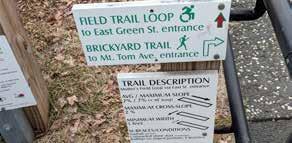
A kiosk gives users information about the site history, slope, and distances of the trails in Easthampton, MA. (Dodson & Flinker)
A diagram of the existing relationship between zones (left) contrasted with a diagram design of what the parking lot could look like if playground was moved and the two parking areas were stacked (right). This would separate pedestrians and vehicles to make the space more functional and safe.
walkway A Sensory Trail For all senses, all people Trail Information Vernal Pool Black Birch Red Maples Eastern Hemlocks Wood Duck Box Fire Pond Tree Cavities Entering the Field A Field Habitat for Birds Field Habitat for Insects Choices We Make Changes to the Land and Picnic Area Nature Center 14
An axonometric model of what the user experience at the redesigned trailhead might look like. Zones are more defined, trail information is made available and a pavilion provides a gathering space to orient the user to the site.
An all-persons trail is woven into the circulation of the parking and visitors center at Arcadia Wildlife Sanctuary. (Mass Audobon)
Trailhead Design II


Trailhead Design II takes similar features from Trailhead Design I so visitors can see the connection between the two properties upon entrance and creates new spaces and pathways for hikers, gardeners, and museum visitors.
A large wooden sign is installed along Ely Road to indicate to users that this area is designated for trail users.
Tire stoppers made out of logs help encourage people to park efficiently in the 12 parking spots.
Three shade trees are planted around the southwestern corner of the parking lot to welcome users and provide relief from the sun.
The southwest portion of the parking lot is resurfaced with crushed stone to point the user towards the start of the trail and more information about the trails.

A 4-foot-wide walkway of crushed stone lines the western and northern sides of the parking lot, designating space for people with limited mobility to access the trails, gardens, and museum.
In place of the current garden shed and portable toilet, which are moved to the southeast corner, a pavilion with informational signs and a seating area for community gardeners and trail users offers a place to gather and orient.


s. maricela escobar adam stoumen spring 2023 18/25 88 Village Hill Rd.Northampton, MA 01060 413-369-4044 www.csld.edu Not for construction. Part of a student project and not based on a legal survey. Two places, One experience a trail plan for flynt park and keep homestead museum T railhead d esign ii
K ee P h o M es T ead M useu M T railhead
F A C B D E
parking ely rd.
Barn Community Garden Trail
Keep Homestead Museum
garden shed pavilion portable toilet A B C D E F
A vehicle scale sign with natural materials indicates the experience at the site in Easthampton, MA. (Dodson & Flinker)
A' A
A pavilion in Waterbury, Vermont abuts a gravel trailhead parking lot and orients users to their adventure. (Green Mountain Club)
All-Persons Trail Design

In the all-persons trail design, visitors can traverse through a multitude of landscapes including the Keep Homestead Museum wetland, the farm fields, and the forest, and can also visit view destinations. Longer and shorter trail loops also gives visitors multiple length options.


T he w e T land a rea T rails
An all-persons trail starts at the Keep Homestead Museum parking lot, descends through two switchbacks on a hayfield, and goes north along the western side of the northern farm field until it connects visitors to the Keep Homestead Museum wetland and another trail. The switchbacks near the parking lot allow for the trail to maintain slope guidelines for an allpersons trail.
An observation platform at the wetland invites visitors to experience a wetland environment, and interpretative signs provide information on the wetland and the intermittent stream. Additionally, a segment is graded on the southeast Flynt Park side for an all-persons trail connection from the Keep Homestead Museum to Flynt Park.
h ayfield e dge T rail
Starting at the Keep Homestead Museum parking lot, this trail traverses along the forest edges of the hay fields, and it connects to the Christmas Fern Trail. This trail would probably require the least disturbance in grading since most segments along the field edges are already less than 8.33 percent slope, and there would be potentially no forest clearing. Additionally, interpretative signs along this trail explain the farming uses over time, providing visitors a connection to the farming history of the Keep Homestead.
f ores T T rail

Connecting from the Keep Homestead Museum wetland, this all-persons trail traverses through a forested area, requiring multiple switchbacks to meet all-persons trail slope guidelines. Additionally, this trail segment avoids building a trail on agricultural land that is under the Agricultural Protection Restriction (APR).
C hris TM as f ern T rail
An all-persons trail is weaved into segments of the current Christmas Fern Trail since some segments of this trail are already at a slope that meets all-persons trail slope guidelines, and to minimize forest disturbance. Additionally, an out and back segment of the trail spur connects visitors to a former quarry.

M oun T ain T o P T rail
Visitors can connect from the Christmas Fern Trail to the boardwalk overlook and the picnic area overlook near the top of Mount Ella. Traversing through a segment of early succession al deciduous forest, the Mountain Top Trail places a boardwalk along a wet segment of the trail. This boardwalk also serves as an overlook where visitors can enjoy a scenic view of the mountain landscape. The picnic area overlook is planted with additional trees without disrupting the views to provide refuge for visitors during warmer months.
88 Village Hill Rd.Northampton, MA 01060 413-369-4044 www.csld.edu Not for construction. Part of a student project and not based on a legal survey. Two Places, One Experience a trail plan for flynt park and keep homestead museum s. maricela escobar adam stoumen spring 2023 19/25 a ll -P ersons T rail d esign
A C D E Playing Field
Wetland Museum Parking Parking A C D E
Hayfield
Hayfield
A boardwalk over a wetland the at Cedar Swamp All Persons Trail in Manchester, NH. (© Sheila Vargas Torres/The Nature Conservancy)
Interpretative signs and resting benches at switchbacks form part of an all-persons trail at Mt. Tom Trailhead Park in Easthampton, MA.
Rest areas including an extended rest area, and a bench on the opposite side at the Mt. Tom Trailhead Park in Easthampton, MA.
P re C eden T s
An all-persons trail at the Cedar Swamp All Persons Trail in Manchester, NH. (© Joanne Glode/The Nature Conservancy)
Signs at wheelchair height indicating accessibility information at the Mutter’s Field Accessible Trail in Easthampton, MA.
Interpretative signs at wheelchair height along an all-persons trail at the Mutter's Field Accessible Trail in Easthampton, MA.
Intermittent Brook Wetland Destination Rest Area All-Persons Trail All-Persons Trail (merged with existing trail) Vernal Pool Bridge Views Property Boundary Existing Trails Closed Trails Boardwalk
Hayfield
B B
Design Spotlight: Wetland Area Trails


New trail segments are created and woven into the existing trails to create an all-persons trail that a greater diversity of people can use.
The all-persons trail begins at the parking lot of the Keep Homestead Museum, descends through a hayfield, and connects to a wetland boardwalk trail and another forest trail. Composed of a series of three shorter loops, these trails connect to each other and form a longer loop.
The trails traverse through a diversity of ecological interesting environments including a wetland, a deciduous forest, an early succession forest, and an extensive under story plant palette. Rest stops are incorporated throughout the trails to meet accessibility guidelines for an all-persons trail, and for the enjoyment of these landscapes. Boardwalks are placed along the wetland and wetter areas for the comfort of visitors throughout the seasons, and to minimize wetland disturbance. Additionally, two bridges are placed: one to cross an intermittent brook, and another one along a wetter area.
Wetland Boardwalk and Observation Platform

An observation platform is connected to the boardwalk, which invites visitors to gather, and to observe a wetland environment. Informative signs educate visitors on wetlands, providing an educational opportunity in addition to recreation.

Intermittent Brook Rest Stop
An extended rest stop and a bench is placed along the intermittent stream where visitors can rest and experience a diverse understory ecology, including ferns and skunk cabbage. The intermittent stream rest stop also provides a sight, hearing, and touch sensory experience.
Connecting Flynt Park and the Keep Homestead Museum
An all-persons trail connects Flynt Park and the Keep Homestead Museum by regrading the southern segment of the Chestnut Avenue Trail, which allows for a greater diversity of users to connect to Flynt Park's eastern side.
88 Village Hill Rd.Northampton, MA 01060 413-369-4044 www.csld.edu Not for construction. Part of a student project and not based on a legal survey. Two Places, One Experience a trail plan for flynt park and keep homestead museum s. maricela escobar adam stoumen spring 2023 20/25 d esign s P o T ligh T : w e T land a rea T rails
A
B C A B
A boardwalk along a wet area forms part of an all-persons trail at the Wallace Lake Sensory Trail in Belchertown, MA. (Photo credit: Jesse Greene)
A bridge across a rain garden at Amherst College in Amherst, MA.
A rest stop along the intermittent brook that runs south to north at the Keep Homestead Museum property provides visitors an additional water connection point to enjoy.
P re C eden T s
A observation platform at the Keep Homestead wetland connects visitors to a wetland ecology.
C Intermittent Brook Wetland Destination Rest Area All-Persons Trail All-Persons Trail (merged with existing trail) Vernal Pool Bridge Views Property Boundary Existing Trails Closed Trails Boardwalk Hayfield Wetland Museum Parking A C Forest Trail Wetland Trail B
A conceptual grading plan that meets all-person trail guidlines of less than 8.33 percent slope on the southern segment of Chestnut Avenue Trail.
Design Spotlight: Forest Trail & Mt. Top Trail


f ores T T rail
Connecting from the wetland trails, the Forest Trail ascends underneath a luscious deciduous forest canopy. This trail largely avoids going along the farms fields with the exception of a small segment on the western edge of the brush-hogged field.


Rest Spot Overlook
A overlook picnic area provides a scenic view of the meadow field, the Keep Homestead Museum and the mountain landscape in the distance.
Christmas Fern and the Hay Field Edge Trails Connectivity
Visitors have the option of connecting to the Christmas Fern Trail or to continue onto the Hay Field Edge Trail to loop back around to the Keep Homestead Museum parking lot.
M T . T o P T rail
Continuing from the Christmas Fern Trail, visitors can experience the top of Mount Ella, an early succession forest, and two gathering places.
Picnic Overlook
Picnic Overlook is the final destination for visitors on the all persons trail. Serving as a resting and gathering area, visitors can take in the view or sit and linger on the picnic tables.


Boardwalk Overlook
A boardwalk with an overlook carries visitors across a wet area. Views feature the mountain landscape in the distance, and exposed bedrock.
An Early Successional Forest Experience
Informational signs highlight the history of the landscape across this area including the 2011 tornado, and the connection to the current early successional forest.
88 Village Hill Rd.Northampton, MA 01060 413-369-4044 www.csld.edu Not for construction. Part of a student project and not based on a legal survey. Two Places, One Experience a trail plan for flynt park and keep homestead museum s. maricela escobar adam stoumen spring 2023 21/25 d esign s P o T ligh T : T he f ores T T rail & M T . T o P T rail
A C B D E
A A E B C D E
Visitors can visit destination views near the top of Mount Ella, and expereince an early successional forest landscape.
An extended rest area at the western side of the brush-hogged farm field provides visitors a place to rest and a scenic view.
An all-persons trail segment through the succession forest provides trail users a changing ecology experience.
An early successional forest trail segment at the Mt. Tom Trailhead Park in Easthampton, MA.
An extended rest area with a kiosk at the Mt. Tom Trailhead Park in Easthampton, MA connects visitors to other trails.
P re C eden T
A picnic area oversees a meadow at the Mt. Tom Trailhead Park in Easthampton, MA.
Intermittent Brook Wetland Destination Rest Area All-Persons Trail All-Persons Trail (merged with existing trail) Vernal Pool Bridge Views Property Boundary Existing Trails Closed Trails Boardwalk
Brush-hogged Field
Christmas Fern Trail
Forest Trail
Mountain Top Trail
All-Persons Trail Guidelines
The USDA Forest Service guidelines on all-persons trails can serve as a resource designing an all-persons trails at Flynt Park and the Keep Homestead Museum.

Surface
The surfaces of the trail tread, resting intervals and passing spaces shall be both firm and stable. Firmness means that the surface is not malleable to depressions, and stability refers to maintaining a steadiness throughout the ebbs and flows of the seasons. (USDA Forest Service)
Clear Tread Width
At a minimum, the clear tread width must be at least 36 inches. (USDA Forest Service)
Resting Interval
A resting interval shall be less than a 5 percent slope. Resting intervals can either be placed on the trail or adjacent to the trail tread. The minimum length shall be 60 inches long. If placed adjacent to a trail, the minimum width shall be 36 inches wide, but if on the trail, the resting interval shall be as wide as the widest trail segment leading up to the rest stop. (USDA Forest Service)
Passing Spaces
The minimum dimensions of a passing space shall be 60 inches by 60 inches, and the slope of a passing space cannot be over 5 percent. (USDA Forest Service)
Cross Slope
The cross slope on an all-persons trail must be less than five percent, and on paved or elevated areas, the slope must be less than two percent. (USDA Forest Service)
Running Slope
An all-persons trail shall have slopes less than 12 percent. Trail segments with less than a 5 percent slope are permitted for any distances. For trails that are steeper than 5 percent but less than 8.33 percent, a resting interval shall be included every 200 feet. Trails that are between 8.33 and 10 percent slope, resting intervals shall be provided every 30 feet, and for trails between a 10 and 12 percent slope, resting intervals shall be available every 10 feet. However, no more than 30 percent of the whole trail shall be at over a 8.33 percent slope. (USDA Forest Service)

s. maricela escobar adam stoumen spring 2023 22/25 88 Village Hill Rd.Northampton, MA 01060 413-369-4044 www.csld.edu Not for construction. Part of a student project and not based on a legal survey. Two Places, One Experience a trail plan for flynt park and keep homestead museum a ll -P ersons T rail g uidelines
Service Road Trails All-Persons Trail Trails with slopes over 12% Map and trails are not to scale.
Boardwalk
B B A A C C D E C D E
Design Details

Large Road Sign
s ignage T rail b uilding T e C hniques

Large signs along Park Rd. (Flynt Park) and Ely Rd. (Keep Homestead Museum) can be installed with the same dimensions and style to tie the trail system together.
Large Kiosk
Large kiosks at each welcome area give the user a sense of the identity of the place. Trail maps and other information about programming can be found here.
N.T.S N.T.S


4X4 wooden posts at the key junctures along the trail indicate (from top to bottom) the trail system, trail name, direction, any destinations, and a blaze unique to that trail.
Trail Sign Reassurance Marker Trail Sign
Reassurance Marker Wheel Stop
N.T.S
For shorter trails and loops, wooden post trail markers should be 60 inches from the trail tread and be securely installed in the ground.
Creating a trail corridor at appropriate widths depending on the type of vegetation along the trail enhances the experience, sight line, and safety for users.
Wheel stops help delineate parking spots and separate zones of use. The distance between the wheel stop and the start of the walkway should be at least 2 feet and six inches.

Drainage Lens Water Bar
By raising the trial, a drainage lens consisting of soil, gravel, and different sized rocks can be placed over persistent wet soil to limit erosion and muddy feet for users.

N.T.S Switchback

Reassurance blaze marks on trees should be placed 5 feet up the tree and be 8 inches in length. One blaze should be visible from the previous.

At 30-45 degrees, a water bar made out rocks is installed where heavy runoff is expected. This helps divert water of the trail tread.
Any signs along the trail should ideally be placed 4 feet from the trail to allow for safe passing.
Where curves are necessary at steep sections of the trail, cutting into the slope at 2% makes an "inslope". A ditch with culverts carries runoff across the trail. Rocks are placed at the radius of the curve to avoid users short-cutting across.
s. maricela escobar adam stoumen spring 2023 23/25 88 Village Hill Rd.Northampton, MA 01060 413-369-4044 www.csld.edu Not for construction. Part of a student project and not based on a legal survey. Two Places, One Experience a trail plan for flynt park and keep homestead museum d esign d e T ails
N.T.S N.T.S
Preliminary Cost Estimates
s. maricela escobar adam stoumen spring 2023 24/25 88 Village Hill Rd.Northampton, MA 01060 413-369-4044 www.csld.edu Not for construction. Part of a student project and not based on a legal survey. Two Places, One Experience a trail plan for flynt park and keep homestead museum P reli M inary C os T e s T i M a T es
Area Item Quantity Unit Cost Per Unit Total Cost Keep Homestead Pond Loop Trail: 5’ wide wooden Boardwalk 3,650 SQ FT $50.00 $182,500.00 Pond Loop Trail Resurfacing of existing trail 5,000 SQ FT $3.00 $15,000.00 Pond Loop Trail: clearing, grubbing, resurfacing 1 LS $3,000.00 $3,000.00 Pond Loop Trail: Regrading from Pond Loop up to Chestnut Ave 600 SQ FT $8.00 $4,800.00 Pond Loop Crushed stone surface material 150 CYD $55.00 $8,250.00 Trailhead pavilion 320 SQ FT Orientation Station 1 LS $10,000.00 $10,000.00 Trailhead pavilion Wooden Benches 2 EA $800.00 $1,600.00 Trailhead pavilion Signs: Move existing kiosk to orientation station 1 LS $1,000.00 $1,000.00 Parking Lot Signs: large trailhead road sign 1 EA $2,000.00 $2,000.00 Parking Lot 3-4” caliber red maple shade trees 3 EA $1,200.00 $3,600.00 Parking Lot 4-6 stall bike rack 1 EA $2,000.00 $2,000.00 Parking Lot Wheel stops 12 EA $60.00 $900.00 Parking Lot 4’ wide crushed stone sidewalk 688 SQ FT $2.00 $1,376.00 Along trail Signs: large interpretive at historic and ecological sites 5 EA $400.00 $2,000.00 Along trail Signs: directional 5”X8” along trail 5 EA $150.00 $750.00 Subtotal $238,776 Flynt Park Southern Parking Lot Overflow parking resurface: re-enforced turf 5,400 SQ FT $5.00 $27,000.00 Southern Parking Lot Overflow parking: wheel stops150 18 EA $60.00 $1,080.00 Southern Parking Lot Asphalt Lot: ADA Symbols & 5’ Aisle 2 EA $250.00 $500.00 Southern Parking Lot Asphalt Lot: Striping 252 LF $1.00 $252.00 Southern Parking Lot Signs: large trailhead road sign 1 EA $2,000.00 $2,000.00 Southern Parking Lot Signs: Kiosk 1 EA $2,000.00 $2,000.00 Southern Parking Lot 3-4” caliber red maple shade trees 10 EA $1,200.00 $12,000.00 Southern Parking Lot 4-6 stall bike rack 1 EA $2,000.00 $2,000.00 Chestnut avenue Wooden benches 2 EA $800.00 $1,600.00 Destinations Signs: large interpretive at historic and ecological sites 5 EA $400.00 $2,000.00 Trail junctures Signs: directional 5”X8” along trail 5 EA $150.00 $750.00 Trailhead pavilion 320 SQ FT Orientation Station 1 LS $10,000.00 $10,000.00 Subtotal $61,182 Total $299,958 Mobilization (1.5%) $4,499.37 Construction survey (1.5%) $4,499.37 Subtotal $308,956.74 Tax, permitting and fees (6%) $18,537.40 Subtotal $327,494.14 Contingency (10%) $32,749.41 GRAND TOTAL $360,243.55
Works Cited & Resources
Baughman, Mel, and Terry Serres. Trail Design for Small Properties. University of Minnesota, 2006.
Boudrie, Jen. “Agricultural Preservation Restriction (APR) APR Program Guide.” Https://Www.mass.gov/ Orgs/Massachusetts-Department-of-Agricultural-Resources, MDAR, www.mass.gov/doc/apr-programguide-0/download. Accessed 31 May 2023.
Center for Design and Interpretation and Rocky Mountain Region. Interpretive Media Design Guidelines. Jan. 2005.
Flink, Charles, et al. Trails for the Twenty-First Century. 2001.
Massachusetts Department of Conservation and Recreation. DCR Trails Guidelines and Best Practices Manual. July 2019.
Minnesota Department of Natural Resources. Trail, Planning, Design, and Development Guidelines.
The Nature Conservancy, New Hampshire. All Persons Trail Guidebook.
Town of Monson and Pioneer Valley Commission. Town of Monson Open Space and Recreation Plan. 2021.
Urban Land Institute and Natinoal Parking Association. The Dimensions of Parking.
USDA Forest Service. Accessibility Guidebook for Outdoor Recreation and Trails. Aug. 2012.
s. maricela escobar adam stoumen spring 2023 25/25 88 Village Hill Rd.Northampton, MA 01060 413-369-4044 www.csld.edu Not for construction. Part of a student project and not based on a legal survey. Two Places, One Experience a trail plan for flynt park and keep homestead museum w or K s C i T ed & r esour C es


