 (c) 2002 MIT Department of Urban Studies and Planning
All rights reserved. No part of this journal may be reproduced in any form by any electronic or mechanical means without prior written permission from the publisher.
Text set: Franklin Gothic Book, Franklin Gothic Medium, Trebuchet. Digitally published using Quark XPress. Printed and bound in the United States of America by Sherman Printing, Canton, MA.
Cover image + photo by Christine Cerqueira Gaspar (c) 2002.
the MIT j 0 urn a I 0 f p I ann i n g
FOUNDER ERYN DEEMING
EDITOR-IN-CHIEF
GREGG P. MACEY
MANAGING EDITOR
SARAH ROSZLER DESIGN + LAYOUT
CHRISTINE CERQUEIRA GASPAR
COPY EDITOR
ROBERT A. IRWIN
FACULTY ADVISORS
JENNIFER DAVIS, ERAN BEN-JOSEPH, KEITH HAMPTON, BALAKRISHNAN RAJAGOPAL
EDITORIAL BOARD
VICKI BEEN School of Law, New York University
ROBERT BULLARD
Department of Sociology + Environmental Justice Resource Center Clark Atlanta University
DANIEL FABER
Department of SOCiology, Northeastern University
RAUL LEJANO
Department of Urban + Regional Planning, University of California, Irvine BRADFORD C. MANK College of Law, University of Cincinnati
RACHEL A. MORELLO-FROSCH
Center for Environmental Studies, Brown University
DARA O'ROURKE
Department of Urban Studies + Planning Massachusetts Institute of Technology
DAVID PELLOW
Ethnic Studies Department University of California, San Diego
DORCETA E. TAYLOR
School of Natural Resources + Environment, University of Michigan
MANY THANKS TO KATE FICHTER, BRENT D. RYAN, BISH SANYAL, LAWRENCE VALE
projections 3

GOSHEN
LEARNS
ENVIRONMENTAL PLANNING GREGG P. MACEY 4
LAND USE JUSTICE TONY ARNOLD 32
INDUSTRIAL ZONING CHANGES IN NEW YORK CITY A Case Study of "Expulsive" Zoning JULIANA MAANTAY 63 SOLVING ENVIRONMENTAL INJUSTICES IN MASSACHUSETTS Forging Greater Community Participation in the Planning Process DANIEL FABER, PENN LOH, JAMES JENNINGS 109
IContents
RESEARCH NOTES THE BOSTON INDUSTRIAL ARCHEOLOGY MAPPING PROJECT KRIS KOLODJIEJ, CHIKAKO SASSA, SUSHILA MAHARJAN 208
THE METAPHYSICAL LANDSCAPE
of Environmental Planning in Val Verde,
CONTRIBUTORS 259
SEGREGATION, RESTORATION + GENTRIFICATION ON THE NORTH FORK Can Participation Prevent Another Injustice? JAAP VOS 133 FORUM GIS METHODS FOR SCREENING POTENTIAL ENVIRONMENTAL JUSTICE AREAS IN NEW ENGLAND CHITRA M. KUMAR 158 DEFINING ENVIRONMENTAL JUSTICE COMMUNITIES EPA Region Five's Approach DAVID RUBIN, NATALIE DAVILA, SHUHAB KHAN, KELLY TZOUMIS 187
FILLING
Aesthetics
Los Angeles County CHIKAKO SASSA 225
GOSHEN LEARNS ENVIRONMENTAL PLANNING
GREGG P. MACEY Massachusetts Institute of Technology Department of Urban Studies + Planning
ABSTRACT
In many respects, the environmental justice movement holds a mirror to the field of planning. A growing body of evidence suggests that land use controls and emerging statutory frameworks can contribute to the overburdening of lowincome and minority districts with the hazards of industrial pollution. At the same time, the distributional effects of planning practice are seldom countered with attempts to adequately enforce industrial performance standards, set up emergency response capabilities, protect residents from the effects of pollution, or include residents in decision-making. This paper documents the efforts of Goshen, North Carolina, an agricultural community that has survived from Reconstruction to the present, to determine the impacts of a wastewater treatment facility on their community. Residents considered the status of heired property, sensitive landmarks, the permitting process, proposed facility design, and the social geography of Goshen through a series of efforts de-linked from the machinations of environmental planning procedures, which progressed in some respects under the assumption that the community did not exist. The manner in which environmental impact assessment, pollution control, and land suitability analysis failed to protect this historically significant community suggests several shortcomings of the planning systems that are assumed to protect human health and the environment. New tasks for planners interested in understanding, learning from, and preventing the distributional effects of planning practice are suggested.

EFFECTS
Over seventy-five years ago, the Supreme Court upheld the power of a municipality to protect residential areas from the pressures of industrial expansion. 1 In the case of Euclid v. Ambler, Ambler Realty Company challenged the Village of Euclid's zoning ordinance as a deprivation of property without due process. The district court invalidated Euclid's classification of "use districts" that separated commercial, industrial, and residential land uses. This decision focused on the case of Buchanan v. Warley, which involved a racial zoning law in Louisville that had been struck down because of its restraint of private property rights (the ability of "a white man to dispose of his property ... to a person of color" and vice versa). 2 In rendering a decision, the district court judge in Euclid weighed the town's justification for its restraint of private property, which was the protection of residents from conditions of blight, with the justification that had been previously invalidated in Buchanan: the separation of racial groups. He argued that:
no candid mind can deny that more and stronger reasons exist, having a real and substantial relation to the public peace, supporting [Louisville's racial zoning ordinance] than can be urged under any aspect of the police power to support the present ordinance as applied to plaintiff's property The blighting of property values and the congestion of population, whenever the colored or certain foreign races invade a residential section, are so well known as to be within the judicial cognizance. 3
The Supreme Court reversed this decision in a ruling that helped to institutionalize the common law theory of nuisance. The four-to-three decision owed much to the brief of Alfred Bettman, a lawyer and city planner, who argued that zoning "represents the application of foresight and intelligence to the development of the community" (Toll, 1969, p. 238). While upholding the constitutionality of zoning, Euclid v. Ambler also encouraged its further use to establish racial districts, as the decision weakened the Buchanan doctrine without addressing the equal protection implications of racial segregation. Directly following the ruling in this case, several cities launched a new array of racial zoning ordinances, encouraged by Euclid's justification for use of the police power. 4 Incompatible and often industrial land uses were in some cases superimposed over these racially zoned districts for a variety of purposes (Rabin, 1989). Minority groups, isolated in these districts, migrating to urban areas during and after the Second World War, or seeking homes in the newly emergent suburbs, faced a plethora of programs promoting continued segregation, and unequal access to the kinds of residential neighborhoods conjured in court opinions affirming the protective use zoning that Euclid upheld (Collin, 1992; Hamilton, 1995; Lambert & Boerner, 1997). 5 In some respects, the emerging statutory framework for environmental protection heightened

PLANNING + DISTRIBUTIONAL
5
the overburdening of isolated, low-income, and minority districts with the hazards of industrial pollution. For example, the Clean Air Act, Resource Conservation and Recovery Act, and other statutes included grandfather clauses exempting existing facilities from more stringent environmental standards, making it easier for these facilities, often clustered in lowincome communities of color, to expand (Robertson, 1995). The patchwork of federal and state environmental laws in general has been found to exacerbate distributional inequities. Lazarus (1994) considered the repercussions of media-specific (i.e., air, water, land) regulations that encourage the shifting of risks from one to the other:
For instance, air pollution scrubbers and municipal wastewater treatment facilities reduce air and water pollution, but only by creating a sludge that, when disposed, will likely impose risks on a segment of the population different than the segment which would have been exposed to the initial pollution in the air or water. Additionally, the incineration of hazardous wastes stored in drums and tanks converts a land disposal problem into an air pollution issue (leaving, of course, a sludge residue that presents a different land disposal problem), and thereby may change the identity of those in the general population exposed to the resulting pollution (p. 794).
Indeed, the environmental justice movement emerged as the confluence of efforts on several fronts to address the discriminatory effects of facility siting processes, environmental agency decisions, and federal and state statutory developments in the area of environmental protection (Cole, 2001). The distributional effects of land use controls and environmental policies on low-income, minority populations in the United States are both well accounted for in the literature (Bullard, 1983; Bullard, 1993; Cohen, 1992; Collin, 1992; Davis, 1981; Gianessi & Peskin, 1980; Robinson, 1984, 1989; Unger, Wandersman, & Hallman, 1992; Weinstock, 1994; White, 1998; Wright & Bullard, 1990; Zimmerman, 1993).
Yet the field of planning continues to playa marginal role in addressing these challenges (Washington & Strong, 1997). Burby (1999) shows that planning texts from the 1950's to the present suggest a "total absence of concern with heavy industry" (p. 15). Schwab (1989), surveying standards used in zoning ordinances regulating industrial land uses, found most were outmoded to a troubling degree. It has been shown that with the advent of federal and state pollution control regulations, local governments began to retreat from their role in developing and enforcing industrial performance standards. For example, Moore (1994) interviewed planners along the industrial corridor stretching from Baton Rouge to New Orleans, Louisiana (a heavy concentration of petrochemical facilities known as "Cancer Alley"). Planners in this region did not see a role for land use regulations or comprehensive planning in the protection of residents from environmental pollution.

6 Pmj",,""", I,
Such reduced capacity at the local level affects municipalities' ability to engage in effective emergency planning. Examining the age and construction of local housing stock to assess its adequacy to support sheltering in place, reviewing land use patterns in neighborhoods along transportation routes to plan effectively for evacuation, and considering the location of schools, hospitals, nursing homes, and other special facilities vis-a-vis industrial facilities are but three of many planning activities that do not receive adequate attention at the local level (Lindell & Meier, 1994). The effectiveness of buffer lones, industrial development moratoria, and other remaining planning tools for protecting minority communities from industrial land uses are also called into question (Burby, 1999; Gramling & Krogman, 1997). Even awareness of local government's inability to set up emergency response and include residents in decision-making can lead to further inequities within existing, overburdened communities. For example, Pikawka et al. (1998) show how in the aftermath of a fire that dispersed a toxic plume of smoke across a two-square-mile area, such sentiments about local government contributed to depressed housing prices within the plume area. Significant differences in housing values within and immediately outside of the plume area emerged within an existing low-income housing market.
Addressing the distributional effects of land use and environmental planning first requires a sense of what went wrong. Yet when the environmental justice movement holds a mirror to the field of planning, it is difficult to tease apart how numerous land use controls, environmental standards, methods of analysis, and practitioner approaches can converge upon a space to yield disproportionate impacts. This volume is dedicated to the community of Goshen, North Carolina, which in one simple yet tragic story allows us to work our way through such complexities.

On April 6, 1999, Goshen Road Environmental Action Team v. United States Department of Agriculture became the first environmental justice claim decided on its merits in the Fourth Circuit Court of Appeals. 6 The story of Goshen, which continues to struggle to preserve its land and CUltural heritage, is a microcosm of the challenges faced by planners concerned with the distributional effects of their decisions, however routine or clearly linked to the general welfare of a place they may seem. The following is the Goshen story, told in community members' own words.
PUBLIC NOTIFICATION BY BULLDOZER
When was the Goshen community founded?
Resident: After Reconstruction, they got together and bought this property. 500 acres. They were brothers. Just this area is supposed to be 100 acres and there were other brothers, the Franklin brothers and Smith brothers, all bought additional acres. You know how they
7
used to say "40, acres and a mule"? I don't know if that was true in this case or not, but it's been a part of our heritage as long as anybody in my family can remember. Part of it has been foreclosed or put up for debt. So Bell owns a portion, as a landlord or when you lend money to farmers and they have a bad crop and can't afford to pay them back, he would foreclose. When I was a child, that's all they ever talked about was going in the Goshen property. White landowners, big landowners, mostly from Trenton, they did everything they could do to get this part. Lawyers, big property owners.
Why did they want the Goshen land?
Resident: People were growing tobacco, peanuts, cotton, and plus it's by a river. You realize how much money can be made now, with riverfront property? People will buy an acre on a river for $15,000 if they can jump across it. But this is good land; it's always been good growing land.
What about the fact that most property in Goshen wasn't deeded?
Resident: That's right, and that's the easiest property to take. Heir property, and we all know that heir property [snaps his fingers], just like that. All you got to do is get one or two heirs to say yeah and you can start your paperwork. And the other ones can't stop it. They can try to stop it but we own a percentage and they can start building on a percentage. That's exactly what happened.

How did people in Goshen first learn about the plans for building the wastewater treatment plant?
Resident: Most of them knew when the bulldozers over here were pushing ground. I can say for myself, I had heard rumors that Pollocksville was taking the Jordan farm. I knew for a fact they had took the Jordan farm, but the day I come in and the bulldozers were pushing off, then I knew it wasn't a rumor But the people said they had been planning that for years. And the man was still tending the farm at the time. But they had been planning that for years, before it ever happened. See, nobody had ever told us about the plans years ago.
There were several sites that were considered for the treatment plant. Why wasn't the plant built on Mr. Bell's land?
Resident: Because Mr. Bell's land, they say it was historical because of slave time and stuff like that. Well, these people [in Goshen] bought their land while their parents were slaves. So if Bell's land is
8
so important because he housed slaves, why weren't these people just as important because they were slaves when they bought their land?
What were your concerns about how the treatment facility was planned?
Resident: Eminent domain was probably the biggest thing. And they did without an environmental impact statement. One of the things that was proven in court but still overlooked was the fact that the plant is 200 feet from my front door. And that was just overlooked. And I think the law said it had to be 500. But the way that the land was confiscated or condemned was underhanded because it wasn't the person who was paying the taxes on it was not given a fair chance to come in and argue. They had already everything was in the works and the land was taken and almost demolition had begun before he even knew about it as well as everybody else in this area.
What are some of the impacts of living near the treatment facility?
Resident: They said you ain't supposed to smell it. Maybe two days a year, with the change of season. But when the wind changes it's an awful smell. Every morning just about, especially rainy weather. And the worst th ing that got me when they first opened was frogs. The smell is something to be concerned about , but I was scared to death of frogs. And my children were home then, and they're girls and they both were terrified. Came in the house one night and a big bullfrog was sitting right there , all in the house , all on the windows. Every time you looked up there were frogs stuck to the windows.

IMacey
Figure 1. STABILIZATION LAGOON VIEWED FROM EDGE OF GOSHEN RESIDENT'S PROPERTY
9
Resident: You can still smell it at night. Especially days when they spray that field. Can't leave no windows up because you'll smell it all night. I'll be down there working in the garden and you smell it in the evening, stuff like that.
Resident: I saw some report that the spray field is one of the oldest ones. It's outlawed now for hog farms to spray with a lagoon like that, and they're dOing it with humans. They closed down a facility like that on a hog farm nearby.
Resident: They say they don't have a problem with sludge because the ground filters so well. That's the reason for spraying it, so that it can soak in the field. It ain't supposed to leak from the lagoon. It's a plastic lining like this cup [points to a drinking cup]. So all of this stays in here, and when it leaves it's being sprayed out in the fields, and yet something's got to be settling on the bottom of the lagoon.
Resident: There's gotta be a sludge.
Resident: And they're talking about it don't smell. It has to smell, when you've got stuff laying there.
What happened to the cemetery?
Resident: You can't destroy a historical site. They went out and found a couple of war veterans, and that made them have to leave the cemetery, they couldn't touch the cemetery. But basically they just left us enough land for the cemetery. Didn't even leave enough land for the cemetery to incorporate the living that's in Goshen right now. There ain't no possible way to expand. They've already got it from three sides and the road got it from the fourth side.
Is there access to the cemetery still?
Resident: You can go from the front. There's a gate but you can go from the front.
Resident: And they moved the fence back. At first, you had to go in and back out or run over some graves. And we complained about that so they moved the fence back about four feet so that you can make a circle.
Do you think that the lawsuit that you filed was inevitable, that it was the only thing that you could do?

10 Projections 13
Resident: The only honest alternative. Because we had tried countless times to talk to the people in Pollocksville, where you got to get on the agenda, where even if you are on the agenda, you got 2 or 3 minutes to speak and that's it. Even the different lawyers had been trying to get on the agendas, and they put you on the agenda and you go there to a meeting which is a little old place not as big as this room and you get 2 or 3 people and that's it. With 2 or 3 minutes to speak, you can't be heard. You know, this side can't be heard. Once the land was taken, the bulldozers wefe sitting over here pushing off. And most people were saying oh, Mr. Jordan and them gonna build some houses. Most people didn't know nothing about it.

Did you ask to be hooked up to the treatment system once it was built?
Resident: Can't be hooked up. Can't be, according to the county. That's for the township of Pollocksville. The township cannot hook no person belonging to the county. And that's why [the sewer line] came right across those people, all the way across the bridge, once you leave the town, the last house is Ms. Parker's. Now Kenny Parker is sitting off, well, he couldn't hook up, because he's at the city line. So all of these people, the sewer line comes across their road, and they can't hook up because it's county property. The township cannot serve the county.
What keeps your organization focused on the treatment facility today?
Resident: After they did start the building, said well, if they's building now that small, we'd better get started because if they start it small, they gonna have to expand. And that's why we started, so they can't expand and take this. This farm and that farm down yonder and the farm on the other side.
How did you know they were starting out small?
Resident: From the size of the lagoon and the number of houses. And if you look at the spray area. Now they can't afford to turn them sprayers on everyday and wet the ground, because it would go off the ground and directly in the river. They don't have enough acreage to do a whole lot of spraying. So that's why they have to alternate it.
You mean day off, day on?
Resident: Yeah, uh-huh. You got to give it a chance to soak up. Even that field right there. Now there ain't no possibility of turning that
IMoo"
11
Figure 2. GOSHEN HOME OVERLOOKED DURING ENVIRONMENTAL ASSESSMENT PROCESS

field on for three days, because the water would run off. It can't soak in. And that's a fact. See I know that, because I farm here. And that's why I'm saying they started off small. And then a rumor came out after they put the sewage plant in, they wanted to hook up a new development across the river, when they had just told us they couldn't go across the river. Now they were saying that they wanted to go across the river to hook up to the development. Hey, we'd better put a stop to it. And that's when we started.
Resident: Knowing it's not over yet. That word "expansion." They'll find some way to try to sneak in, and will. You always gotta stay on your toes. The next we'll look and they'll be bulldozing our house down. So you always gotta look out for that expansion.
Excerpts of interviews with residents of Goshen, June 28, 2000
Unlike communities that were established by racial zoning, Goshen was at first isolated by choice. A 500-acre tract in Jones County, North Carolina, Goshen is surrounded by the Trent River, a tributary called Goshen Branch, and the cotton fields of E. E. Bell's farm. The manor house on the Bell farm (now on the National Register of Historic Places) is famous for its chandelier, which once hung in the Confederate White House. The majority of Goshen's residents trace their ancestry to the 1870's (Brief of Appellant, 1998). The founders were escaped slaves who settled along an old trail used by Native Americans. The seclusion offered by the tract of land protected them from Ku Klux Klan attacks. At the time, Jones County's senator, Furnifold Simmons, led a white supremacist movement that resulted in the disenfranchisement of black voters across the state. A portrait of the senator still hangs in the Jones County Courthouse (Cecelski , 2000). Residents of Goshen also had to contend with Jim Crow farming policies and low prices for certain crops (Cecelski, 1995).
Projections 13
12
Black-owned farmland in Jones County dwindled from 29% in 1940 to 3% in 1998, when blacks constituted 43% of the population (Brief of Appellant, 1998). Goshen is a rare example of a black agricultural community that has survived in North Carolina from Reconstruction to the present.
About a mile to the east of Goshen sits Pollocksville, a small town that is nearly 90% white (Brief of Appellant, 1998). The town showed interest in developing a sewage system starting in 1984, when it requested information from the Army Corps of Engineers regarding the 100-year-flood elevation for the area. An environmental assessment (EA) was prepared by the Department of Agriculture (USDA) in 1986 for the construction of a wastewater treatment system. The project, which was to replace the town's failing septic tanks, called for an 81,600-gallon-per-day stabilization lagoon treatment facility with effluent to be discharged into the Trent River. Among the declarations made in the 1986 EA concerning impacts of the proposed project were:
1. Hydrogen sulfide is the only emission associated with the continued operation of the proposed facility. Hydrogen sulfide produces a rotten egg odor that is noticeable during temperature inversion periods. Temperature inversion occurs two times per year during season changes. This odor may be noticed by persons living down wind of the facility.
2. The proposed stabilization lagoon will, over several years, produce waste in the form of sludge as solids begin to settle out.
3. The State Historic Preservation Officer determined that there were no properties of architectural, historic, or archaeological significance which would be affected by the proposed project.

4. No persons will be relocated as a result of the proposed project.
5. A stabilization lagoon method of treatment was selected due to lower construction costs and lower operation and maintenance costs.
6. There are three endangered animal and two endangered plant species in Jones County. The lagoon site has been selected to avoid the habitats of these species.
7. The project was reviewed by all appropriate State environmental protection agencies. No questions of inconsistencies with the State Environmental Policy Act have been raised.
8. Local reaction to the proposed project has been favorable.
IMacey
13
Discussions regarding the project at town meetings have revealed strong support for the project (USDA, 1986).
In 1990, Congress reauthorized the Coastal Zone Management Act, requiring states with federally approved coastal zone management programs to develop non-point pollution control plans (Gengenbach, 1994a). The Trent River was reclassified as "nutrient-sensitive" by the State, meaning point source dischargers (such as the project outlined in the 1986 EA) had to reduce phosphorus concentrations to 2 milligrams per liter (USDA, 1991). Pollocksville changed its proposed project to a land-based application system, citing the latter's lack of impact on the Trent River and "the advantage of being less likely to be affected by changing discharge regulations (USDA, 1991). By 1994, numerous controversies had erupted in the region over issues of wastewater treatment. These were fueled by the discharge of wastewater into Brices Creek, algae blooms that turned the Neuse River orange from overfertilization, sludge backups at a treatment plant in Havelock, Jones County's failure to offer sewer service to five predominantly black neighborhoods near Trenton, and capacity shortages that led Craven County to expand its spray irrigation system into Croatan National Forest (Bridges, 1994; Gengenbach, 1994b; Jones, 1994; Little, 1994; "Neuse River," 1994).
The 1991 amendment to the 1986 EA considered both a new method for discharging effluent (spray irrigation instead of river discharge) and a new location for the project. Yet the 1991 amendment ends, on page two, by determining that "the changes to the proposed project do not alter the conclusion reached in the April 28, 1986, assessment" (USDA, 1991, p. 2). There was one additional site visit made before the amendment was prepared. In October 1990, Farmers Home Administration officials visited the site to assess the value of six acres of "important farmland" to be converted for construction of the lagoon. The original Finding of No Significant Impact (FONSI) issued with the 1986 EA was upheld, and a permit was issued to the town by the State Department of Environmental Health and Natural Resources (DEHNR) in October 1993. A compliance officer with the DEHNR explains the impetus for this particular permit:
That's what Senator Edwin Muskie envisioned when he developed the Clean Water Act in 1972, was national pollution discharge elimination systems; and then to move these to non-discharge systems. So we pushed, and so did some local environmental types, for the town to go to a non-discharge system. That also took the load off the Trent River at that point, which was showing nutrification, and quite honestly the town probably could not have afforded nutrient removal anyhow. So it was the lesser of evils and supported good environmental, sound practices, to go to the non-discharge pre-irrigation system. Quite honestly, probably cheaper. So that's what was chosen. Anytime that you spray wastewater or build a sewer plant,

14 Projections 13
there's opposition. It's in somebody's backyard. For the life of me I could not see and was not even aware of the fact that there was a local concern there in Pollocksville against the spraying of this effluent, because it's out in the country; nobody lives around it. It's a beautiful site, very sandy. It's several acres. There are two separate spray sites, one on the same side of the highway that the dual lagoon system is located on, and then the one across the street which is a much larger site, and they're planted with coastal Bermuda grass (telephone interview with Compliance Officer, DEHNR, February 6, 2000; emphasis added).
What the officer did not know, even several years later, was that the spray fields ("risers" that sprayed treated wastewater in 360-degree arcs across hundreds of yards) and treatment lagoon were located within the Goshen community.

At least one resident of Goshen, James Bullock, became aware of the planning process in early 1992. Bullock owned a mobile home park on Goshen Road, which rented to low-income tenants. Bullock learned that the town was in the process of condemning land in the Goshen community for the purpose of establishing a treatment plant. He wrote to numerous public officials, starting with the mayor of Pollocksville, James Bender. Bullock's conversations with the Environmental Protection Agency's Water Quality Section revealed that a minimum 450 yards buffer zone was required around the kind of system being planned. Bullock found that "many of the home sites under development as well as existing home sites are within the prescribed distance" (letter to James Bender, Mayor, Town of Pollocksville from James Bullock, Committee Chairman, January 14, 1992). The mayor replied, indicating "We have been informed that our system complies in all respects with federal and state laws" (letter to J. H. Bullock from James Bender, Mayor, Town of Pollocksville, January 15, 1992). Bullock was undeterred. In subsequent months he would write to the town a second time, and to the Director of Environmental Management in Raleigh, Congresswoman Eva Clayton, Senator Jesse Helms, the EPA, and the USDA, while corresponding with his attorney about appropriate next steps. In many of these efforts Bullock attempted to document the extent of the project's impacts by describing properties and their distances from the site. For example, Bullock estimated the following distances in a letter to the mayor in 1993:
Our objections to the proposed plant are as follows:
That 150 yards from the drain line of the proposed plant is a residence within a development that may include as many as ten units upon its completion (Franklin Development)
That 150 yards from the drain line across the road from the Franklin
IMacey
15
Development is one residence with four others being in close proximity
That due east of the proposed sewage treatment site and approximately two-tenths of a mile are twelve individually owned homes (Ward, Jordan, Kinsey, Chapman, Gray, James, Koonce, Jordan, Collins, Cox, Strayhorn, and Williams)
That also within the three-tenths of a mile distance are now three individually owned black businesses that rent to low-income families. At present, there are eleven units. When these three developments are completed, there will be as many as fifty-two low-income rental units between the Town of Pollocksville's city limit and the proposed sewage treatment site (0.7 mile)
That a sewage treatment plant of this type (aerial spray) would produce an odor that would be very offensive to those residents located within the community.
In February 1994 Bullock wrote to the Director of Environmental Management, demanding "a public hearing to discuss the unsuitability of locating a sewage treatment facility in close proximity to a large residential area." The project permit had already been issued.
Bullock made two important decisions in 1994. First, he requested the project's EA and FONSI, a copy of the announcement alerting residents of the proposed project, dates on which residents were given opportunities to hear of the development, and any documents approving the use of federal funds for the project (letter to Harold Pearman, Director, Farmers Home Administration from James Bullock, Committee Chairperson, March 1, 1994). Through these records, he discovered that properties in the immediate area of the plant had not been addressed. He also learned that had it not been for a recent court action, town officials would have included the entire family cemetery site in the project's drainage area. Even so, "now there is no room for future burial plots and graves have been disturbed" (letter to James Fuller from James Bullock, April 25, 1994). Bullock's second important decision was to call Gary Grant, President of the Concerned Citizens of Tillary (CCT). Tillary is a New Deal community established under President Roosevelt and the largest African-American resettlement in the program (interview with Gary Grant, June 26, 2000). CCT was active in oppOSing factory farms in the region. Bullock saw Grant on a "60 Minutes" documentary on the hog farms and called to ask for his assistance:
I went down to have a community meeting with them and we went from one thing to the other. Their concern was that a sewage plant was being put in their community that was, one, they were not gonna

16 Projections 13
be tapped on to, it was a system that would service the incorporated town which happened to be majority white, it was going through their cemetery and also caused I believe some folk not to have access to their land, it was some way or another that the lines were gonna prevent people from being able to get to some property that they had (interview with Gary Grant, June 26, 2000).
By August 1994 Grant had helped Bullock and other Goshen residents to establish a coalition of organizations that would attempt to block the construction and operation of the facility. 7 Members of the coalition went on a fact-finding mission to Goshen. Their notes paint a picture of the project's impacts that is quite different from accounts in the EA:
100 yards from trailer park 200 feet from nearest household (cesspool)
Sewage pipes run directly through a 200-year-old cemetery; last burial was May 1994 Will not service the community in which it is located 30 homeowners, 35 current renters in park with 65 units possible Reports of land taken by county and one case of the county denying landowner access to land
(Blue Ridge Environmental Defense League, 1994).
By September, Bullock was "no longer alone in his efforts to fight the construction and opening of the facility" (letter to J. Bullock et al. from Gary Grant, September 26, 1994). On September 22, 1994, members of the Goshen community began to hold monthly meetings with coalition members, who elected Iris Brown their president and called themselves the Goshen Road Environmental Action Team (GREAT). At this point, the stabilization lagoon was 85% complete and sewage lines were already being installed along State Route 1337 (letter to Eva M. Clayton, United States House of Representatives from James Kearney, State Director, United States Department of Agriculture, Farmers Home Administration, October 14,1994).
The coalition raced to gather whatever information was available on heired property, family histories, impacts on the cemetery, the permitting process, the proposed facility deSign, and chemicals that should be considered during well water testing (GREAT, 1994). One of the coalition members, the Land Loss Prevention Project (LLPP), was a legal services organization for black landowners across the state. LLPP first became aware of the Goshen community when one of the heirs of Samuel Jordan (the original land owner in Goshen) requested legal assistance in fighting Pollocksville's condemnation action (interview with LLPP attorney, January 29, 2000). An attorney for LLPP contacted an engineer, who reviewed the proposed treatment plant and found that another site would have been more

IMacey
17
suitable. He also found that "this type of facility has a history of big environmental problems. The smell will be outrageous and muskrats love the lagoon in this kind of plant" (GREAT. 1994). Unfortunately, the engineer was not willing to go on record with his assessment.
The environmental permitting process had ended, leaving GREAT to try to block further construction and operation. Iris Brown spoke at County Board of Commissioners and Town Council meetings in December 1994. The focus of residents' concerns was on adverse effects of chemicals and odors connected with facility operations, property devaluation, limits and damage to the Goshen cemetery, the denial of sewer services to Goshen residents, and the fact that more land would be needed to expand sewage treatment operations. Brown's request for a vote on continued construction was denied, and in both instances she was referred to the EA as proof of no environmental impact on the residents of the area (GREAT. 1995). The meetings ended a two-year attempt to register Goshen'S concerns with regulatory bodies and elected officials, a process that led to nothing more than explanations of limited agency jurisdiction by some and the citing of existing documents by others.
With avenues of public participation exhausted, GREAT sought administrative relief by filing a Title VI complaint with the USDA in January 1995. Title VI of the Civil Rights Act of 1964 states that "No person in the United States shall, on the ground of race, color, or national origin ... be subjected to discrimination under any program or activity receiving Federal financial assistance." 8 The treatment facility was financed by the Farmers Home Administration (FmHA) of the USDA, which provided over $2 million in the form of grants and loans to the town of Pollocksville. FmHA regulations, promulgated under the aegis of Title VI, state that "No recipient of FmHA financial assistance will select sites or locate facilities with the purpose or effect of excluding individuals from, denying them the benefits of, or subjecting them to discrimination under any programs to which the regulations in this subpart apply." 9 The complaint outlined evidence that Pollocksville and the FmHA had failed to properly evaluate the discriminatory impact of the project on Goshen residents. It (a) refuted statements made in the original EA regarding air quality, the report of the State Historic Preservation Officer, and the design of the facility; (b) outlined inconsistencies in the site selection process; and (c) documented near- and long-term effects on the Goshen tract (Brown. 1995). For the latter, it cited a letter by DEHNR engineer Randy Gould regarding the facility:
Item 2 of your letter addressed the expandability of the proposed Treatment Lagoon and Spray Field. The Town of Pollocksville would have to buy land to expand the proposed treatment plant. There is ample available land around the existing Treatment Plant site. However, funds were not available to purchase land at this time for

18 Projections 13
Pollocksville, which used its powers of eminent domain to acquire the original site, would be in a position to condemn further properties should the need arise for project expansion. The complaint requested immediate action to halt federal funding for the facility.
GREAT members continued to meet regularly, documenting further evidence of project impacts while the opening date for the treatment plant drew near. Pollocksville began to distribute mailings to town customers regarding system hookups in March 1995 (Town of Pollocksville, 1995). Goshen residents scrambled to determine the opening date for the facility. With time running out, LLPP filed a civil complaint on their behalf, seeking declaratory and injunctive relief from the unlawful placement, approval, and funding of the treatment facility by the FmHA (which by this time was referred to as the Rural Housing and Community Development Service) and the town. 10 The district court denied plaintiffs' motion for a temporary restraining order lion the facility, which opened to demonstrations in early May 1995 (Blue Ridge Environmental Defense League, 1995). LLPP attorneys worked with GREAT to appeal the district court ruling. On at least two occasions, GREAT sent settlement proposals to the defendants' attorneys, which were rejected. 12 The Court of Appeals found that the siting decision did not violate Title VI or contravene the National Environmental Policy Act, which governs major federal actions "significantly affecting the quality of the human environment." 13 GREAT's challenges to the wastewater treatment facility were exhausted by this ruling on April 6, 1999. 14
Because the Court of Appeals relied heavily on the district court's ruling, it is helpful to consider the primary argument behind the lower court's denial of a temporary restraining order. 15 When a plaintiff asks the court to grant preliminary injunctive relief (i.e., to temporarily put a stop to a project), the court must balance the "likelihood of irreparable harm" to the plaintiff against the "likelihood of irreparable harm" to the defendant, pending trial. 16 Only if the imbalance of hardships is found to be in favor of the plaintiffs can the court consider whether plaintiffs are likely to succeed on the merits of their case. In the case of GREAT v. USDA, the district court found that plaintiffs' harms fell "more into the classification of nuisance than of environmental hazard," because their claims of potentially noxious odors, pest infestations, and other effects were not adequately documented or quantified. (Recall that the plant had not commenced operation and GREAT was unable to find an engineer willing to go on record about the project design.) Thus, the court found that harms to plaintiffs would be in the form of nuisances rather than "injuryinducing dangers." Defendants, on the other hand, were able to clearly

IMacey
future expansion considerations (Letter to John Seymour, N.C. Department of Environmental Health and Natural Resources, Division of Environmental Management, from Randy Gould, Senior Professional Engineer, October 14,1993).
19
portray what would happen should the project be even temporarily delayed: the town would be unable to make loan payments after its next payment of $37,900. Sixty-four members of the public were already "online" to use the system, with over 100 more expected. Most of these residents of Pollocksville had converted their septic tanks to the sewer line at their own cost, and would have to bear the cost of reconversion. In light of this analysis, the court found that the balance of hardships favored the defendants, and denied plaintiffs' motion for preliminary injunction.
The Court of Appeals agreed with the district court's balancing of hardships, and further ruled that the project did not violate the National Environmental Policy Act (NEPA), because (a) the 1986 environmental assessment referenced effects on the "Pollocksville area" and the town's "environs," not just Pollocksville, and (b) economic or social effects are not intended by themselves to require preparation of an environmental impact statement. 17 GREAT members sought an activity permit to protest the Court of Appeals decision, but the town of Pollocksville denied their request for a protest march (Town of Pollocksville, 1999).

WHAT WENT WRONG?
On paper, regulators and the courts received reassurances that the traditional elements of environmental planning, including pollution control, environmental impact assessment, and land suitability analysis, were serving their intended purposes in the above case. But the impacts uncovered by residents and the process of discovery that propelled them toward litigation suggest numerous shortcomings of the planning systems that are assumed to protect human health and the environment. As with many cases of environmental injustice, several dynamics coalesced to ensure that the impacts of a sewage treatment plant would be concentrated on an isolated, low-income, minority community:
1. a shifting of environmental harms from one medium to another (water to land);
2. use of unincorporated land by a municipality to site undesirable land uses or attract industry;
3. an environmental assessment process with alternatives chosen by a project engineer prior to the involvement of the public;
4. limited avenues for public participation;
20 Projections 13
5. state agencies that have limited contact with or knowledge of the physical or social geography of sites under consideration;
6. a NEPA process that privileges fiscal and other easily quantifiable considerations over social and cultural impacts (Johnson, 1997); and
7. a court system that engages in a "balancing of harms" or cost-benefit analysis after a project receives federal funds and environmental clearance.
Pollocksville sought financial assistance for a wastewater treatment facility. With the help of a federal agency, it completed an environmental assessment. Federal legislation in the form of the Clean Water Act and the NPDES program discouraged Pollocksville from disposing of its effluent in the Trent River and caused the town to seek a more cost-effective, land-based alternative. Despite the shift in project design and new location, impacts were not reconsidered. Four alternative site locations were chosen by the town for the new land-based option, according to soil type. Each soil type had moderate to high capacity to treat waste constituents. Two of the tracts were black-owned and two were white owned, although 95% of the land in the surrounding area was owned by whites. Some tracts of land near Pollocksville with soil types suitable for the proposed project did not receive consideration. White-owned tracts were rejected because they were "not large enough for the project," although soil and engineering reports never validated this claim. Further justification for rejecting one alternative was that it required crossing a creek to the east of Pollocksville that fed into the Trent River. In fact, Pollocksville rejected all land options to the north and east of the town because they would have required sending waste over Mill Creek or the Trent River itself. However, the Goshen site required siting the treatment facility in swampland and taking the sewer force main under the Goshen Creek, which also fed into the Trent River.
Following the choice of the Goshen tract, the town commenced condemnation proceedings. The town took advantage of the fact that the Goshen tract was on unincorporated land, meaning acceptance of the project by nearby residents was not required. County land was not zoned, removing a further obstacle. Pollocksville secured federal funding for the project. The USDA approved a combination of grants and loans, relying in large part on the town's due diligence:
Because, see, what happens is, a town, a public body, has the powers of condemnation. OK? Therefore, we assume that they have then made the determination on location and so the immediate impacts on population, I don't know that we fully considered those (interview with USDA manager, February 4, 2002).

21
Contrary to the belief of federal officials, no such determination had been facilitated. The town published notice of the proposed project in another county's newspaper. An amendment to the original environmental assessment concluded that public support for the project was high, although this statement was based on public meetings held in Pollocksville before the Goshen tract was considered as an option. Environmental impacts and threats to historically significant properties were ignored, and findings made for the initial assessment were upheld. Construction commenced just as the first resident of Goshen became aware of the facility. Letters to agencies and elected officials yielded no action. Through such correspondence, residents tried to document the distance between housing units and the project, the historical significance of their community and its gravesite, and odor and pest problems. Such issues were ignored by a federal agency that had minimal contact with the Goshen tract residents during the assessment process. When these attempts to encourage action failed, an administrative complaint was filed. It was not answered in time to block operation of the treatment facility. Opening day for the plant drew near.
Goshen's final hopes rested with the courts, which based their rulings on cost-benefit analysis, a powerful tool for constructing "rational basis" arguments to justify planning decisions that yield unequal treatment on the basis of race or socioeconomic status. 18 Planners have traditionally turned to cost-benefit assessments for resolving problems caused when decision-makers or market forces fail to take into account important external effects (Berry & Steiker, 1974). However, such methods are only useful when the interests of those affected can be viewed in commensurate units. In the case of Goshen, it was impossible to quantify such costs as the physical division of a historically significant community, infringement on a cemetery, or environmental nuisances or potential harms. Thus, they could not be compared with the easily documented effects of federal funding cessation on the town and its sewer customers. Goshen exemplifies the focus of much of planning practice on decisions that involve conflicting interests where maximized net benefits will not necessarily prevent or may even require certain groups suffering extreme losses in order to subsidize others. When such situations present themselves, the key consideration should shift from net benefits to the distribution of costs among groups.

NEW TASKS FOR PLANNERS
The case of Goshen illustrates how planning processes and techniques can interact, as they are called upon to address a given locale, to yield environmentally inequitable outcomes. In light of the challenges posed by such dynamics, a focus on objective standards and traditional decisiontheoretic approaches to policy analysis can limit practitioners to one of
22
several available modes of planning response. Niebenck (1993) points out that while environmental planners spend more of their time on rules and rule-making than on any other subject, they must also be adept at such tasks as place-making. That is, the need to discover the subtle and complex story of a place in order to acquire legitimacy as an interpreter of that place's agenda suggests that an entirely different set of skills is needed to supplement a strong background in quantitative and microeconomic reasoning. New planning roles, such as entrepreneurial planning, community mobilization, and mediation and negotiation are needed to facilitate the kinds of "targeted," "principled" actions that could have addressed the concerns of Goshen and numerous other isolated, low-income, and minority communities (Friedman & Keuster, 1994). 19 Even while some of these new roles begin to receive increased attention in planning education, there continues to be a sense of declining interest among planners in issues of poverty, and a retreat from advocacy in general (Krumholz & Forester, 1990; Forester, 2000). Such trends can translate into a reluctance of planners to engage in the kinds of tasks necessary for addressing the shortcomings of environmental and land use planning, including:

engaging in a level of place-specific and historical analysis necessary for understanding the development of overburdened communities (Boone & Modarres, 1999);
interpreting and communicating residents' social construction of environmental risks and harms (Taylor,2000);
addressing the specific interests and concerns of local residents by developing and combining innovative mechanisms for public participation (Burby & Strong, 1997);
adjusting operations research and other environmental planning methods so that they capture the intensity of environmental problems and means of coping with them that are unique to historically overburdened communities (Daniel, Diakoulaki, & Pappis, 1997);
leveraging municipal resources and personnel for monitoring compliance with control laws and performance standards; and
linking top-down regulation of pollution sources and environmental assessment more closely to local spatial planning (DeRoo & Miller, 1997).
What happened in Goshen reaffirms the need for planning educators and scholars to focus on these new roles and tasks, which can counterbalance existing tools for rationalizing planning decisions with innovative
IMacey
23
means of understanding and learning from their distributional effects.
The papers in this issue of Projections, The MIT Journal of Planning, written by students, scholars, and practitioners, suggest that progress has, in fact, been made toward achieving this balance:
TONY ARNOLD introduces us to the dominant conceptions of environmental justice, and shows how each has insufficiently considered land use planning. He compiles data from seven cities to suggest a correlation between low-income, high-minority neighborhoods and the allowing of intensive land uses. Based on the results of his study, Arnold presents an alternative, based on planning principles and techniques, to community opposition for pursuing environmental justice. The shaping and negotiating of local land use policies are necessary elements of an effective approach to reversing the distributional effects of prior planning practice.

JULIANA MAANTAY continues her important work on the non-neutral impacts of zoning. She analyzes zoning changes from 1961-1998 in New York City to illustrate how changes to manufacturing zones correspond with the demographic makeup of proximate residential communities. Combining extensive archival and Geographic Information Systems analysis, Maantay is able to illustrate broad trends across the region as well as unique place-specific dynamics in Bathgate, Bronx and the Lower West Side. She concludes by considering the extent to which increased public participation or Fair Share Criteria might address the distributional inequities that result from zoning changes.
DANIEL FABER, PENN LOH, and JAMES JENNINGS discuss a vibrant environmental justice movement in Massachusetts and suggest challenges that arise as it begins to adopt a proactive, regional approach to environmental planning and problem solving. The challenge of promoting development alternatives that are economically and environmentally sustainable at an appropriate scale requires new forms of capacity building, public participation, and decision-making. The authors use the Roxbury Master Plan as an example of a visionary planning process for critiquing the top-down assumptions of economic development. New planning processes such as the Roxbury Master Plan can be coupled with methods of filling gaps in existing environmental regulations (such as the proposed Areas of Critical Environmental Justice Concern), to address the uneven distribution of environmental hazards in Massachusetts that is thoroughly documented in this paper.
JAAP VOS shows through historical analysis how the North Fork of the New River in Broward County, Florida, has been preserved as an unintended consequence of racial segregation. He documents the threat of gentrification to the predominantly African-American community and suggests how existing regulations designed to prevent environmental injus-
24 Projections 13
tices will not apply to this case. Vos suggests that new methods of public outreach are needed for unearthing and communicating a long-term vision for the area, and presents preliminary evidence of such a process.
CHITRA KUMAR builds on her investigation of how different regions of the Environmental Protection Agency, in response to Executive Order 12898, have begun to define communities that should be given added consideration and protection because of their demographic makeup or share of environmental burdens. She provides an account of how EPA Region I considered numerous characteristics and thresholds in developing a set of criteria for screening potential environmental justice communities that can be used by regulators and the public through a desktop GIS database.

DAVID RUBIN, NATALIE DAVILA, SHUHAB KHAN, and KELLY TZOUMIS focus on the RCRA permitting process in EPA Region V. They assess the limits inherent in any single criterion for assessing community demographics in order to locate areas that should receive additional scrutiny during the siting process. This study suggests how additional layers of environmental protection can have the unintended consequence of further isolating overburdened communities. The authors suggest a low-cost means of adding nuance to the assessment of environmental justice communities.
KRIS KOLODJIEJ, CHIKAKO SASSA, and SUSHILA MAHARJAN develop a new methodology for assessing the accumulation of environmental risks over time, through the collection and analysis of Sanborn Fire Insurance Maps using GIS. Methods for overlaying historical data with present-day census and public health information in order to identify industrial "hot spots" and areas of elevated risk are discussed. The result, an "archeology of risk," will lead the way toward new understandings of cumulative risk, brownfield assessment and cleanup, and disproportionate burdens. The tool will also encourage new dialogues between city planners, regulators, and communities as they come to terms with a new understanding of environmental hazards and their spatial distribution.
Finally, CHIKAKO SASSA begins the process of bridging the gap between technocratic approaches to environmental planning and the unique experience of place shared by residents of a contaminated community. Through analysis of the cultural artifacts of residents of Val Verde, California, home of the Chiquita Canyon Landfill, Sassa shows how residents' construal of their landscape as dynamic, multidimensional, and threatening points to areas for improvement in the traditional construal of landfills as enclosed, static compartments.
Collectively, these papers point to many exciting initiatives and ideas that are only beginning to take root in the fields of environmental and land use
IMacey
25
planning. In response, we must consider how the new roles for planners, concepts of regulation, understandings of place, and accessible technologies developed by those who have submitted their work to this issue of Projections can be incorporated into more effective planning teaching and practice. Future Goshens across the country and, indeed, around the world will expect nothing less from us.
Acknowledgments
The author thanks the residents of Goshen, including Iris and Jack Brown, Hattie Brown, and James Bullock, for sharing their story. By kindly opening your doors to a complete stranger, you helped to open his eyes.
REFERENCES
Bender, J. (1992, January 15). Letter to J.H. Bullock from James Bender, Mayor, Town of Pollocksville.
Berry, D., & Steiker, G. (1974, November). The concept of justice in regional planning: Justice as fairness. American Institute of Planning Journal, 414-421.
Blue Ridge Environmental Defense League (1994, August 1). Results of fact-finding mission to Pollocksville, NC, made by Gary Grant, Chris Stewart of CCT, and Theresa Vick of BREDL.
Blue Ridge Environmental Defense League (1995, March 27). Notes from Strategy Meeting with GREAT, prepared by the Blue Ridge Environmental Defense League.
Boone, C. G. & Modarres, A. (1999). Creating a toxic neighborhood in Los Angeles County: A historical examination of environmental equity. Urban Affairs Review, 35(2), 163-187.
Bowens, S. (1999, April 9). Letter to Barbara Kocher, Assistant United States Attorney from Stephon Bowens, Attorney for Land Loss Prevention Project.
Bridges, B. (1994, January 24). Craven, state seek sewer solution. Sun Journal, p. A1.
Brief of Appellant, Appeal from the United States District Court for the Eastern District of North Carolina Eastern Division, Goshen Road Environmental Action Team et al. v. United States Department of Agriculture et aI., in the United States Court of Appeals for the Fourth Circuit, Record No. 98-2102, October 2, 1998.

Brown, E.M. (1995, January 20). Title VI Complaint filed on behalf of the Goshen Road Environmental Action Team by E. Maccene Brown, Attorney for Land Loss Prevention Project.
Brown, E.M. (1996, August 9). Letter to Barbara Kocher, Assistant United States Attorney from E. Maccene Brown, Attorney for Land Loss Prevention Project.
Bullard, R. (1983). Solid waste sites and the Houston black community. Sociological Inquiry, 52(2/3), 273-288.
Bullard, R. (1993). Environmental racism and land uses. Land Use Forum: A Journal of Law, Policy, and Practice, 2, 6-11.
Bullock, J. (1992, January 14). Letter to Jay Bender, Mayor, Town of Pollocksville from James Bullock, Committee Chairman.
26 'ml'.U,"s I,
Bullock, J. (1993, no date). Letter to Jay Bender, Mayor, Town of Pollocksville, from James Bullock.
Bullock, J. (1994, February 2). Letter to Preston Howard, Director of Environmental Management from James Bullock, Owner, Bullock's Mobile Home Park.
Bullock, J. (1994, March 1). Letter to Harold Pearman, Director, Farmers Home Administration from James Bullock, Committee Chairperson.
Bullock, J. (1994, March 2). Letter to Ernesto Perez, Acting Section Chief, United States Environmental Protection Agency, Region 4 from James Bullock.

Bullock, J. (1994, April 25). Letter to James Fuller, Attorney from James Bullock, Bullock's Mobile Home Park.
Burby, R. J. (1999). Heavy industry, people, and planners: New insights on an old issue. Journal of Planning Education and Research, 19, 15-25.
Burby, R. J., & Strong, D. E. (1997). Coping with chemicals: Blacks, whites, planners, and industrial pollution. Journal of the American Planning Association, 63(4}, 469-480.
Cecelski, D. (1995, Spring). Goshen's land. Southern Exposure.
Cecelski, D. (2000). A Historian's Coast: Adventures into the Tidewater Past. Winston-Salem, NC: John F. Blair.
Clayton, E. (1994, November 21). Letter to James Bullock, Bullock's Mobile Home Park, from Eva M. Clayton, Member of Congress.
Cohen, L. (1992). Waste dumps toxic traps for minorities. The Chicago Reporter, 21(4}, 611.
Cole, L. (2001). From the ground up: Environmental racism and the rise of the environmental justice movement. New York: New York University Press.
Collin, R. W. (1992). Environmental equity: A law and planning approach to environmental racism. Virginia Environmental Law Journal, 11, 495-546.
Collin, R. w., & Morris, R. A. (1989). Racial inequality in American cities: An interdisciplinary critique. National Black Law Journal, 11, 177-183.
Daniel, S. E., Diakoulaki, D. C., & Pappis, C. P. (1997). Operations research and environmental planning. European Journal of Operational Research, 102, 248-263.
Davis, M. E. (1981). The impact of workplace health and safety on black workers: Assessment and prognosis. Labor Law Journal, 4, 29-40.
De Roo, G., & Miller, D. (1997). Transitions in Dutch environmental planning: New solutions for integrating spatial and environmental policies. Environment and Planning B, 24, 427-436.
Forester, J. (2000). Why Planning Theory? Educating citizens, recognizing differences, mediating deliberations. In L. Rodwin and B. Sanyal (Eds.), The Profession of City Planning. New Brunswick, NJ: Rutgers, The State University of New Jersey Press.
Friedmann, J., & Kuester, C. (1994). Planning education for the late 20th century: An initial inquiry. Journal of Planning Education and Research, 14, 55-64.
Gengenbach, L. (1994a, January 30). Pollocksville fears pollution rules. Sun Journal, p. A1.
Gengenbach, L. (1994b, February 10). Algae bloom turns Neuse orange. Sun Journal, p. A1.
27
Gianessi, L., & Peskin, H. M. (1980). The distribution of federal water pollution control policy in the U.S. Land Economics, 56 (1), 85-102.
Gould, R. G. (1993, October 14). Letter to John Seymour, N.C. Department of Environmental Health and Natural Resources, Division of Environmental Management, from Randy Gould, Senior Professional Engineer, Regarding WQ0007283 Town of Pollocksville Wastewater Treatment and Spray Irrigation Disposal Facilities, Rivers File 91063D.
Gramling, R., & Krogman, N. (1997). Communities, policy, and chronic technological disasters. Current Sociology, 45 (3), 41-57.
Grant, G. (1994, September 26). Letter to James Bullock, Florence Bowen, Maxine Brown, Barry and Ellen Baker, Theresa Vick, Willie Dawson, Melanie Earnhardt, Connie Tucker and Delain Garner, and Chris Stewart from Gary Grant, Concerned Citizens of Tillary, Regarding Community Meeting in Pollocksville.

Grant, G. (1994, December 9). Letter to Iris Brown, Chairperson, Goshen Road Environmental Action Team from Gary Grant, Executive Director, Concerned Citizens of Tillary, Regarding Pollocksville Town Council Meeting.
GREAT (1994, November 11). Minutes for Legal Strategy Meeting of Goshen Road Environmental Action Team.
GREAT (1995, January 14). Minutes for Meeting of Goshen Road Environmental Action Team.
Hamilton, J. T. (1995). Testing for environmental racism: Prejudice, profits, political power? Journal of Policy Analysis and Management, 14(1),107-132.
Helms, J. (1994, November 16). Letter to James Bullock from Jesse Helms, Member of the United States Senate.
Howard, A.P. (1993, October 25). Letter to James Bender, Mayor, Town of Pollocksville from A. Preston Howard, Director, Division of Environmental Management, North Carolina Department of Environmental Health and Natural Resources, Regarding Permit No. WQ0007283.
Johnson, S. M. (1997). NEPA and SEPAs in the quest for environmental justice. Loyola of Los Angeles Law Review, 30, 565.
Jones, S. (1994, August 21). EPA pressures Jones on Trenton sewage. Sun Journal, p. Al.
Kearney, J. (1994, October 14). Letter to Eva M. Clayton, United States House of Representatives from James Kearney, State Director, United States Department of Agriculture Farmers Home Administration.
Krumholz, N & Forester, J. (1990). Making equity planning work: Leadership in the public sector. Philadelphia: Temple University Press.
Lambert, T., & Boerner, C. (1997). Environmental inequity: Economic causes, economic solutions. Yale Journal on Regulation, 14, 195-234.
Lazarus, R. (1994). Pursuing "environmental justice": The distributional effects of environmental protection. Northwestern University Law Review, 87,787-857.
Lindell, M. K., & Meier, M. (1994). Planning effectiveness: Effectiveness of community planning for toxic chemical emergencies. Journal of the American Planning Association, 60(2), 222-234.
Little, S. (1994, July 13). Sludge could block city growth. Sun Journal, p. Al.
28 Projections 13
McGee, H. W. (1970). Urban renewal and the crucible of judicial review. Virginia Law Review, 56,826.
Moore, D. M. (1994). Planning policy in the lower Mississippi River corridor. New Orleans: Louisiana Urban Technical Assistance Center, College of Urban and Public Affairs, University of New Orleans.
Neuse River sewer system gets OK for 2nd discharge. (1994, January 16). Sun Journal.
Niebanck, P. (1993). The shape of environmental planning education. Environment and Planning B, 20, 511-518.
Pijawka, K. D., Blair, J., Guhathakurta, S., Lebiednik, S., & Ashur, S. (1998). Environmental equity in central cities: Socioeconomic dimensions and planning strategies. Journal of Planning Education and Research, 18, 113-123.
Rabin, Y. (1989). Expulsive zoning: The inequitable legacy of Euclid. In C. Haar & J. Kayden (Eds.), Zoning and the American dream: Promises still to keep. Chicago: Planners Press, American Planning Association.
Robinson, J. C. (1984). Racial inequality and the probability of occupation-related injury or illness. Milbank Quarterly, 62, 567-588.
Robinson, J. C. (1989). Exposure to occupational hazards among Hispanics, blacks, and non-Hispanic whites in California. American Journal of Public Health, 79, 629-630.
Robertson, H. G. (1995). If your grandfather could pollute, so can you: Environmental "grandfather clauses" and their role in environmental inequity. Catholic University Law Review, 45, 131.
Schwab, J. (1989). Industrial performance standards for a new century. PAS Report 444. Chicago: American Planning Association.
Taylor, D. (2000). The rise of the environmental justice paradigm: Injustice framing and the social construction of environmental discourses. American Behavioral Scientist, 43(4), 508580.
Toll, S. (1969). Zoned American. New York: Grossman.
Town of Pollocksville (1995, March 27). Letter to Town of Pollocksville Wastewater System Customers.

Town of Pollocksville (1999, April 12). Request for Activity Permit, Submitted April 12, 1999, Denied April 13, 1999.
Unger, D. G., Wandersman, A., & Hallman, W. (1992). Living near a hazardous waste facility: Coping with individual and family distress. American Journal of Orthopsychiatry, 55, 62.
United States Department of Agriculture, Farmers Home Administration (1986). Environmental assessment: Town of Pollocksville wastewater system. Added to Project File with Finding of No Significant Impact on April 29, 1986.
United States Department of Agriculture, Farmers Home Administration (1991, February 5). Town of Pollocksville amendment to environmental assessment.
Washington, R. 0., & Strong, D. (1997). A model for teaching environmental justice in a planning curriculum. Journal of Planning Education and Research, 16, 280-290.
Weinstock, M. P. (1994). Tired of being dumped on. Occupational Hazards, 56(4), 42-48.
IMacey
29
White, H. L. (1998). Race, class, and environmental hazards. In D. E. Camacho (Ed.), Environmental injustices, political struggles: Race, class, and the environment. Durham: Duke University Press.
Wright, B. H., & Bullard, R. D. (1990). Hazards in the workplace and black health. National Journal of SOCiology, 4, 45-52.
Zimmerman, R. (1993). Social equity and environmental risk. Risk Analysis, 13(6), 649-666.
ENDNOTES
1 Village of Euclid v. Ambler Realty Co., 272 U.S. 365 (1926).
2 Buchanan v. Warley, 245 U.S. 60 (1917).
3 Ambler Realty Co. v. Village of Euclid, 297 F. F. 307,312-313 (N.D. Ohio 1924), rev'd, 272 U.S. 365 (1926).
4 In March 1927, Texas called for all municipalities to delineate separate residential districts based on race. TEX. REV. CIV. STAT. ANN. Art. 1015-b (repealed 1969). Winston-Salem, North Carolina, Oklahoma City, and Apopka, Florida, followed suit in adopting racial zoning ordinances in 1930, 1933, and 1937, respectively. Clinard v. City of Winston-Salem, 6 S.E.2d 867,868 (N.C. 1940); Allen v. Oklahoma City, 52 P.2d 1054,1058 (Okla. 1935); Dowdell v. City of Apopka, 511 F. Supp. 1375 (M.D. Fla. 1981), aft'd, 698 F.2d 1181 (11th Cir. 1983).
5 For example, the Federal Housing Administration and the Veterans Administration, charged with providing mortgage insurance for low- and middle-income families, engaged in such practices as redlining (denying mortgages to entire minority neighborhoods), racially restrictive covenants, and the separation of "incompatible racial elements" (Collin & Morris, 1989). Federal public housing programs assigned tenants to segregated housing projects until at least 1972, when the Department of Housing and Urban Development required the siting of new housing on a non-segregated basis. 24 C.F.R. § 941.202 (1992); 24 C.F.R. § 880.206 (1992). Other programs such as the Federal Slum Clearance and Urban Renewal Program resulted in the displacement of countless minority families, many of which were relocated in segregated housing. United States Housing Act of 1949, Pub. L. No. 81-171, §§101-110, 63 Stat. 413, 414-21. See McGee (1970).
6 Goshen Road Environmental Action Team et al. v. United States Department of Agriculture et al., No. 98-2102 (4th Cir. 1999).
7 The coalition included Eco-Force (furnished a list of chemicals for well testing), the Land Loss Prevention Project (began research on heired property and impacts on the cemetery and filed a lawsuit on behalf of the residents), Blue Ridge Environmental Defense League (compiled files on the permitting process), Concerned Citizens of Tillary (facilitated communications, coordinated meetings, and sought technical assistance), Pamelic,o Sound Legal Services, and the Southern Organizing Committee.
8 42 U.S.C. Section 2000d.
9 7 C.F.R. 1901.202.
10 Complaint, Goshen Road Environmental Action Team, Iris Brown, and Hattie Brown v. United States Department of Agriculture, Rural Housing and Community Development Service, Administrator of Rural Housing and Community Development Service, North Carolina State Director, Rural Housing and Community Development Service, and Town of Pollocksville, No. 4:95-CV-36-H(1), April 13, 1995.
11 Goshen Road Environmental Action Team et al. v. United States Department of Agriculture et al., 891 F. Supp. 1126 (E.D. N.C. 1995).

30 Projections 13
12 For example, LLPP sent Barbara Kocher, Assistant United States Attorney, a proposed settlement on August 9, 1996. The following terms were included: independent inspection of the facility testing wells on a quarterly basis with notification of the results; regular treatment of the wastewater in the lagoon in order to reduce and eliminate odors; regular pest control on the premises of the facility and on property of residences within 1/8 mile of the facility; reasonable and fair compensation for decrease in property values; access to the Jordan family cemetery and expansion of the area to a size sufficient for 40 additional graves and space for a driveway; easements to plaintiffs who own property adjacent to the facility but who are presently denied access; establishment of a fund to treat illnesses determined to be caused by the facility; placement of a historical marker on Goshen Road to commemorate the contributions and history of the Jordan-Loftin families; and establishment of a scholarship fund in the amount of $50,000 for the benefit of members of the Jordan-Loftin families (letter to Barbara Kocher, Assistant United States Attorney from Maccene Brown, Attorney, Land Loss Prevention Project, August 9, 1996). This and a similar proposal submitted on April 9, 1999 by LLPP attorney Stephon Bowens were both rejected.

13 40 C.F.R. Section 1501.4(b)-(c).
14 Supra note 6.
15 Supra note 11.
16 Capital Tool and Manufacturing Company v. Maschinenfabrik Herkules, 837 F.2d 171, 172 (4th Cir. 1988).
17 Supra note 6.
18 See, for example, Hawkins v. Town of Shaw, 303 F. Supp. at 1168-69. Rational basis was applied in Euclid v. Ambler when the Supreme Court relied on an empirical justification for use districts that was given in "comprehensive reports." Euclid v. Ambler, 272 U.S. at 394.
19 Targeted actions include meeting crises, righting wrongs, bridging gaps, filling needs, and healing wounds. Principled actions involve consideration of ethical arguments that justify particular planning actions.
IMacey
31
LAND USE JUSTlCE*
CRAIG ANTHONY (TONY) ARNOLD Center for Land Resources, Chapman University School of Law
ABSTRACT
In a modified republication of the first comprehensive study of the relationship between environmental justice and land use regulation, Professor Tony Arnold contends that environmental injustice is due in large part to unjust patterns of land use generally, not just to siting of specific environmental hazards. The article contains the findings of an empirical study of zoning patterns in thirty-one census tracts in seven cities. The study shows that low-income, high-minority census tracts have a greater percentage of their area zoned for industrial and intensive commercial uses than do high-income, low-minority census tracts. The article also discusses the features and benefits of a "planning model" of environmental justice. The planning model focuses on empowering low-income communities of color to influence local land use plans, controls, and patterns. The planning model is an alternative or supplement to the traditional "oppositional model" of environmental justice that is inherently reactive and remedial.
* Reprinted in part, with modifications, from Arnold (1998), with permission of the University of Denver College of Law. See also Arnold (in press).
INTRODUCTION
Environmental justice has emerged as a major issue in environmental law with almost no corresponding attention to the role that urban planning and land use regulation can play in addressing environmental injustice or to the role that environmental justice will play in shaping land use. 1 This article explores the relationship between environmental justice and land use regulation and planning -a relationship that planners, scholars, lawyers, judges, and policy makers must increasingly understand.
ENVIRONMENTAL INJUSTICE AS LAND USE INJUSTICE
Environmental justice is about the growing awareness of, and response to, the distributional inequities of environmental harms and risks, including locally unwanted land uses (LULUs), by race and class (Been, 1993; "Principles of Environmental Justice", 1991; Torres, 1992). In the 1980s and "1990s, grassroots community organizers and civil rights activists, civil rights lawyers, government agencies, legal scholars, and other academics began to recognize and demonstrate that low-income people and people of color bear a disproportionately high burden of exposure to environmental hazards or LULUs, particularly in the neighborhoods in which they live and the environments in which they work (Collin, 1994; Manaster, 1995; Shanklin, 1997). There have been five primary responses to this phenomenon, each with corresponding conceptions of, or ways of thinking about, the environmental justice problem 2 : 1) to study the evidence and causes of the distribution of environmental hazards and LULUs (evidentiary conceptions) (Been, 1995; Been & Gupta, 1997; Bullard, 1990; United States General Accounting Office, 1983; Mohai & Bryant, 1992; United Church of Christ Commission for Racial Justice, 1987); 2) to organize politically against proposed or existing LULUs (power conceptions) (Bullard, 1993; Cole, 1992; Gauna, 1995); 3) to vindicate the constitutional, statutory, or common law rights of those affected disproportionately by environmental hazards or LULUs (legal conceptions) (Binder, 1995; Cole, 1994; Colopy, 1994; Gauna, 1995; Lazarus, 1994; Reich, 1992); 4) to heighten enforcement of environmental laws (environmental conceptions) (Kaswan, 1997; Mata, 1994; Moya, 1996; Tarlock, 1994); and 5) to seek or rely on market mechanisms to address the distribution problem (economic conceptions) (Been, 1994; Jaffe, 1995; Lambert & Boerner, 1997).
Each of these dominant ways of thinking about environmental justice, like each set of tools used by environmental justice advocates, is largely reactive and remedial. The focus of these conceptions is on opposition to particular facilities, practices, and permits, and thus can be viewed as part of an oppositional model of environmental justice. It is hardly surprising that neighborhood groups, civil rights activists, progressive lawyers, and grassroots environmentalists have responded to decades of dumping hazards and LULUs in minority and low-income communities with demands to stop and remedy the existing situations. However, there
IArnold
33
is a need, and growing trend, to consider the distribution of land use patterns generally by race and class and to use land use planning and regulation as proactive, prospective means of addressing environmental injustice (Torres, 1994).
Environmental justice is, in substantial part, a land use justice issue. Much of the scholarship on environmental justice has focused on one or more of three issues: 1) the siting of particular facilities subject to environmental regulation, such as toxic waste sites, hazardous waste incinerators, and solid waste landfills; 2) the application of civil rights laws to federal and state environmental laws and regulations that permit and limit facilities with adverse environmental impacts; and 3) the social justice and community empowerment goals of grassroots environmental justice groups. Each of these concerns can be understood better from a land use planning perspective.
First, questions about disparate exposure to environmental harms by race and class should encompass not only particular LULUs regulated by federal and state environmental laws, but also zoning patterns and local land use planning practices. This article describes the results of an empirical study of zoning patterns, showing that low-income, minority neighborhoods have a disproportionately high percentage of industrial and commercial zoning (i.e., more intensive land uses) than do highincome, low-minority neighborhoods. Thus, the environmental injustices that persons of color and poor persons experience involve land use patterns generally, not just particular LULUs or risks from exposure to discrete pollution sources.
Second, federal and state permitting and siting of LULUs arise in the context of local land use plans, regulations, and permits. Local land use laws allow the spatial proximity of intensive land uses, including waste transfer and disposal sites and other LULUs, to residences, schools, parks, and other facilities in areas inhabited by high percentages of low-income persons of color. Although some state siting laws preempt local land use regulation (Arnold, 1998, pp. 130-132), the local government often has the power to zone low-income and minority neighborhoods in ways that exclude, limit, or buffer LULUs in those areas. In general, the local land use regulatory power exists independently of the authority of federal and state environmental bureaucrats to grant or deny operational permits to particular facilities with respect to certain pollution emissions.
Indeed, many environmental justice controversies involve not only federal and state environmental permits but also local land use approvals. For example, the environmental justice cases of East-Bibb Twiggs Neighborhood Association v. Macon Bibb Planning & Zoning Commission 3 (concerning a landfill in Macon, Georgia) and Security Environmental Systems, Inc. v. South Coast Air Quality Management District 4 (concerning
34 Pmjecl;ons I,
a hazardous waste incinerator capable of burning more than 450 chemicals at a rate of two tons per hour) involved local grants of conditional use permits. The celebrated environmental justice case concerning the attempt to site. a hazardous waste incinerator in predominantly Hispanic Kettleman City, California, EI Pueblo Para el Aire y Agua Limpio v. County of Kings 5 , arose out of the Kings County Planning Commission's consideration of a conditional use permit for the incinerator and the accompanying required environmental impact study. Furthermore, environmental justice advocates are using civil rights theories to challenge local land use plans and zoning ordinances that disproportionately allow environmentally intensive uses among or near low-income neighborhoods of color. 6
Third, environmental justice groups do not seek merely the limitation or even elimination of environmentally hazardous land uses in low-income minority neighborhoods. These groups also seek empowerment of lowincome people of color. They see the problem as a lack of power, not just a distribution of environmental risks. The particular social justice vision of environmental justice advocates emphasizes grassroots activism, from-the-ground-up social change, and layperson influence over environmental and land use decisions (Cole & Foster, 2001, p. 14).
In light of these developments, it seems odd that much of the environmental justice literature and a surprising proportion of activist efforts focus on federal environmental decision making. At the federal agency level (e.g., the Environmental Protection Agency), grassroots lay people, particularly low-income persons of color, arguably have low levels of influence and encounter political, financial, technical, and legal obstacles to effective participation in shaping decisions. Most land use planning and regulation, however, occurs at the local level, where residents arguably have greater access and potential to exert influence than at the federal level. In addition, decision makers at the local level make determinations about the appropriateness of industrial land uses among or near residential areas based on non-technical evaluations of a range of potential land use impacts, not merely a technical evaluation of risk to human health from exposure to pollutants. Thus, land use planning provides a more optimal avenue than environmental regulation for low-income, minority residents to enhance their influence over government decisions and to prevent or limit LULUs from interfering with their quality of life.
EMPIRICAL EVIDENCE OF INEQUITABLE DISTRIBUTION OF LAND USE REGULATORY PATTERNS
Land Use Regulatory Patterns: The Ignored Environmental Justice Issue
The five dominant conceptions of environmental justice evidentiary, power, legal, environmental, and economic have insufficiently consid-
IArnold
35
ered land use planning and regulation. Not only has there been sparse attention to planning concepts, and no attention to the strategic use of regulatory tools, but there has been very little systematic documentation of the unequal distribution of land use regulation on the basis of race and class. 7
The use of zoning and other land use regulatory mechanisms (e.g., requirement of large lots, minimum floor space, and significant setbacks; low-density zoning; and restrictions on multi-family housing) to exclude low-income people who cannot afford large single-family homes on large lots (i.e., exclusionary zoning) has been well documented (Rohan, 1998; Dubin, 1993; Young, 1996). Exclusionary zoning has had the effect of contributing to and perpetuating residential segregation not only by class but also by race (Rohan, 1998, pp. 2-6; Dubin, 1993, p. 740).
In addition, Yale Rabin (1990) has focused scholarly attention on "expulsive zoning," the practice of local governments rezoning neighborhoods of color to allow incompatible and noxious land uses, thereby displacing ("expelling") some residents and replacing them with new industrial and commercial activities that threaten the health, safety, quality, and character of the neighborhood (Dubin, 1993, p. 742). Rabin documented his analysis of expulsive zoning with twelve case studies of zoning changes in different cities nationwide that had the effect of displacing minority residents (Rabin, 1990, pp. 108-118). However, Rabin's study did not attempt to quantify the distribution of zoning patterns in low-income neighborhoods of color and compare those distributions with zoning patterns of highincome white neighborhoods in the same cities. The distributional studies that have emerged in the environmental justice literature have focused on specific LULUs, not on land use regulatory patterns. 8 This article documents land use regulatory patterns the percentages of areas designated for different land uses in thirty-one census tracts in seven cities nationwide. Low-income, minority communities have a greater share, not only of LULUs, but also of industrial and commercial zoning, than do high-income white communities.
Methodology
The study measures the percentages of area in census tracts that local zoning ordinances have designated for each type of land use. It contains data from thirty-one census tracts in seven cities: Anaheim, California; Costa Mesa, California; Orange, California; Pittsburgh, Pennsylvania; San Antonio, Texas; Santa Ana, California; and Wichita, Kansas. All data in this section come from the 1990 U.S. Census. Two census tracts analyzed fall outside the political jurisdiction of the applicable named cities but are completely surrounded by the cities: Terrell Hills, which is a separately incorporated city surrounded by the City of San Antonio, Texas, and is census tract #1204; and Eastborough, which is a separately incorporated borough surrounded by the City of Wichita, Kansas, and is cen-
36
sus tract #74. For purposes of this study, these two "pocket" cities are treated as part of their respective ambient cities. For all practical purposes, these "pocket" cities are not suburban fringe cities, but instead are predominantly white, upper-income neighborhoods within the ambient city's geographic and psychological boundaries. Because these neighborhoods are separately incorporated, their residents do not have to pay taxes to fund the ambient cities' urban programs and are not controlled by the land use and other municipal decisions of the ambient cities' governing bodies. However, these "pocket" city residents participate in the political, economic, and civic life of the larger ambient city (Ford, 1994).
The cities were selected on the basis of several criteria:
1. Geographic diversity: Pittsburgh is in the Northeast; Wichita is in the Midwest; San Antonio is in the South/Southwest; and Anaheim, Costa Mesa, Orange, and Santa Ana are on the West Coast.
2. Population diversity 9: San Antonio, with a population of 935,933, is the tenth-largest city in the United States. However,. it is part of the thirtieth-largest standard metropolitan statistical area, which has a population of 1,302,099. Thus, most of the population in the San Antonio metropolitan area is within the City of San Antonio itself. Pittsburgh, on the other hand, is the fortieth-largest city with a population of 369,879. Yet it is within the nineteenth-largest metropolitan area, containing a population of 2,242,798. Only a small percentage of the total Pittsburgh metropolitan area population resides within the City of Pittsburgh. Wichita is a medium-size city, ranking fifty-first in city population (304,011) and seventy-fifth in metropolitan area population (485,270). The four remaining cities Santa Ana (population of 293,742), Anaheim (population of 266,406), Orange (population of 110,658), and Costa Mesa (population of 96,357) are part of the second largest metropolitan area in the United States, encompassing more than 14.5 million people who live in Los Angeles, Orange, Riverside, San Bernardino, and Ventura Counties. All four cities are in Orange County, which has a population of more than 2.4 million people. Thus, they are medium to small cities in a large metropolitan area.
3. Racial diversity: Two cities have very high percentages of people of color: Santa Ana has 76.6% people of color, predominantly Hispanic and Asian, and San Antonio has 63.6% people of color, predominantly Hispanic. Anaheim has 43.4% people of color, and Orange has 31.9% people of color. Both of these cities have significant Hispanic and Asian populations. Pittsburgh has 28.5% people of color, predominantly AfricanAmerican. Costa Mesa has 27.6% people of color, predominantly Hispanic. Wichita has 19.5% people of color, predominantly AfricanAmerican.
I Amold
37
4. Land use development diversity: Pittsburgh is an old city that developed along natural features, particularly the convergence of three rivers. Wichita is a traditional Midwestern grid-pattern city. San Antonio has an old but partially redeveloped core, barrios, and new suburban and outerring office development, but most of the greater metropolitan area lies within the city boundaries. The four California cities are mostly twentiethcentury edge cities (Garreau, 1991; Teaford, 1997), parts of the Orange County metropolitan area, which has no central core.
5. Spatial segregation by race and class: Each of the cities has at least one census tract with a high (or in one case, a moderately high) percentage of minorities and a high percentage of low-income persons, and at least one census tract with a low percentage of minorities and a low percentage of low-income persons, thus allowing for measurement of whether low-income communities of color bear a higher percentage of non-residential zoning designations than white, wealthy communities.
6. Study feasibility: The author had means of readily obtaining the zoning maps and codes of each of these cities.
Census tracts were chosen by reviewing 1990 U.S. Census Bureau census data on the racial composition, median household income, and percentage of persons below the poverty level for all the census tracts of each city. 10 Census tracts were chosen for being either significantly above or significantly below the racial and class composition of the city. All high-income, low-minority census tracts selected for this study had less than 50% of the respective city's percentages for people below poverty and people of color, except Anaheim Tract #219.04. This tract had 22.1% people of color, which was 50.9% of Anaheim's percentage people of color (43.4%), but less than 32% of Anaheim's high-minority census tracts (i.e., 874.02 and 874.03) that were studied. Thus, the percentage of people of color in tract 219.04 was significantly less than the percentage in Anaheim's high-minority tracts.
In absolute, as opposed to relative, measures, all high-income, low-minority tracts in all cities had less than 27% people of color, and eight out of the twelve tracts had 14% or less. The high-income, low-minority tracts had less than 8% people below poverty, and nine out of twelve tracts had 4.5% or less.
All low-income, high-minority tracts were more than 150% of their respective city's percentages of people below poverty and people of color, except for two tracts in San Antonio and three tracts in Santa Ana. These five exceptions had less than 150% of the respective city's percentages of people of color due to the high number of people of color in those cities. Each of the five tracts had more than 85% people of color, and three of the tracts had 92% or more.
38 Proje""oos I,
In absolute measures, all low-income, high-minority tracts in all cities had more than 45% people of color, and sixteen out of the nineteen tracts had more than 69%. All low-income, high-minority tracts had more than 15% people below poverty, and thirteen out of nineteen tracts had 33% or more.
After data on the racial composition, median household income, and percentage of persons below the poverty level were gathered from the 1990 U.S. Census data for each census tract, the census tracts were identified on U.S. Census Bureau maps. Zoning maps for the areas corresponding to the census tracts were obtained from local zoning authorities. The census tract boundaries were correlated to the zoning maps. For each census tract, the areas of zoned land on the map were measured using fine hand measurement tools according to each land use deSignation (e.g., R-1, R-2, C-1, LI), and the percentage of the total area within the entire census tract zoned for each separate land use designation was calculated.
Data + Analysis
The census data and percentages of each census tract deSignated for particular zoning are not provided here, but may be found in the tables in the Appendix to the original published version of this article (Arnold, 1998, pp. 140-153). However, data for aggregated zoning deSignations singlefamily residential, multi-family residential, commercial, industrial, planned development, and other are provided in the tables in this section, following the textual discussion of the data.
The data show that low-income, high-minority neighborhoods in the cities studied are subjects of more intensive zoning, on the whole, than highincome, low-minority neighborhoods. This conclusion is supported by data from across the various types of cities studied, regardless of the cities' geographic features, spatial development, population, political characteristics, and the like. With respect to industrial zoning, the most intensive land use, thirteen out of nineteen low-income, high-minority census tracts had at least some industrial zoning, and in seven of those census tracts, the city had zoned more than 20% of the tract for industrial uses. In contrast, only one of the twelve high-income, low-minority census tracts contained any industrial zoning at all, only 2.84% of the tract.
More specifically, Santa Ana tract #744.03, an area of 4,862 people, of whom 74.9% are Hispanic, is 90.54% zoned for industrial use. Nearly 70% of Orange tract #762.04, about 50% of both Pittsburgh tract #2808 and San Antonio tract #1105, and 36.59% of San Antonio tract #1307.85 are zoned for industrial use. 11 Moreover, although the study did not include a quantified spatial distribution analysis of the industrial uses in comparison to the residential uses, a visual survey of the zoning
IArnold
39
maps reveals that industrial use designations are close to residential use designations, often either across the street or in the same block.
The zoning of low-income neighborhoods of color for industrial uses places highly intensive activities near local residents' homes, creating the very sort of incompatibility of uses that zoning is designed to prevent (Council on Environmental Quality, 1974, pp. 51-54). 12 For example, among the "as of right" permitted uses in Pittsburgh tract #2808 are ammonia and chlorine manufacturing, automobile wrecking, blast furnace or coke oven, chemical manufacturing, iron and steel manufacturing and processing, airplane factory or hangar, brewery, poultry slaughter, and machine shop, and among the conditional uses are atomic reactors, garbage and dead animal reduction, rubbish incineration, radio and television transmission and receiving towers, and storage of explosives and inflammables. 13 The City of San Antonio allows acetylene gas manufacturing and storage, arsenals, blast furnaces, boiler works, cement or paving material mixing plants, creameries with onpremises livestock, forge plants, metal foundries, paper and pulp manufacturing, rock crushers, junk storage, tar roofing manufacturing, and yeast plants, among others, in two of the census tracts studied. 14 Although nearly two-thirds of Orange census tract #762.04 is zoned for industrial manufacturing (M2), the City requires many of the most intensive uses to obtain conditional use permits, thus at least theoretically allowing some level of monitoring and control of the impacts. Nevertheless, some of the conditionally permitted uses in Orange's M2 district are hazardous waste facilities, refuse transfer stations, blast furnaces and coke ovens, mineral extraction and production, and various types of chemical production. 15 Santa Ana has zoned nearly 90% of census tract #744.03, containing nearly 5,000 residents, for light industrial activity. Although Santa Ana's light industrial zoning designation excludes hazardous and solid waste facilities and some hazardous industrial activities like acid manufacturing, gas and acetylene manufacturing, and metal smelters, it does not exclude large-scale industrial facilities that can overwhelm nearby residential uses, the use of toxic substances in light industrial activities, unsightly storage facilities and
High·income, low·minority census tract
Low·income, high·minority census tract
Single·family residential (includes low·density residential)
Multi·family residential (includes two·family residential, duplex residential, manufactured housing, mobile home residential, and medium· and high·density residential)
Commercial (includes business and professional)
Industrial
Planned Development
Other (includes open space, park/recreation, country club, public use, government center, and special [Pittsburgh])
40 PmJ,eU.ns I,
Legend for Tables and Graphs Symbol Term * # SFR MFR C I PD 0
Table 1. ANAHEIM, CALIFORNIA, PERCENT OF CENSUS TRACTS BY AGGREGATED ZONING DESIGNATIONS
Tract SFR MFR C I PO 0 219.04 * 94.98 4.84 0.17 0 0 0 874.02 # 22.74 25.42 16.99 23.74 11.12 0 874.03 # 57.94 12.5 22.59 3.34 3.63 0
Table 2. COSTA MESA, CALIFORNIA, PERCENT OF CENSUS TRACTS BY AGGREGATED ZONING DESIGNATIONS
Tract SFR MFR C I PO 0 638.02 * 57.82 5.05 16.67 0 0 20.46 637 # 32.25 25.51 28.68 4.79 0 8.78
Table 3. ORANGE, CALIFORNIA, PERCENT OF CENSUS TRACTS BY AGGREGATED ZONING DESIGNATIONS
Tract SFR MFR C I PD 0 219.12* 25.89 0 0 2.84 49.83 21.44 762.04 # 0 8.08 20.46 68.84 0 2.61
Table 4. PITTSBURGH, PENNSYLVANIA, PERCENT OF CENSUS TRACTS BY AGGREGATED ZONING DESIGNATIONS
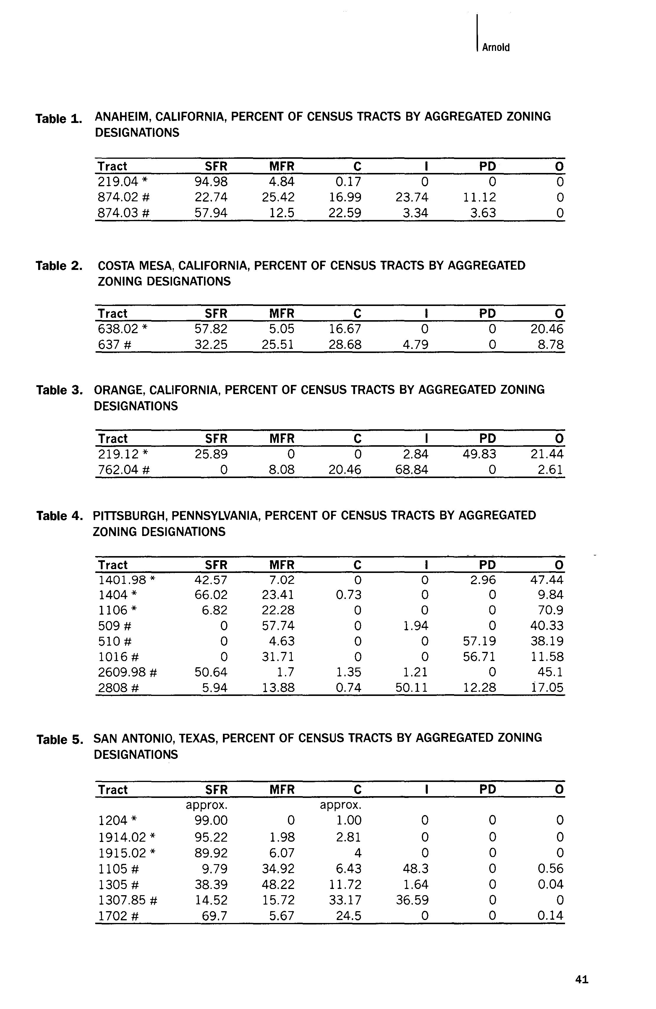
Tract SFR MFR C PO 0 1401.98* 42.57 7.02 0 0 2.96 47.44 1404* 66.02 23.41 0.73 0 0 9.84 1106* 6.82 22.28 0 0 0 70.9 509 # 0 57.74 0 1.94 0 40.33 510 # 0 4.63 0 0 57.19 38.19 1016 # 0 31.71 0 0 56.71 11.58 2609.98 # 50.64 1.7 1.35 1.21 0 45.1 2808 # 5.94 13.88 0.74 50.11 12.28 17.05
Table 5. SAN ANTONIO, TEXAS, PERCENT OF CENSUS TRACTS BY AGGREGATED ZONING DESIGNATIONS
Tract SFR MFR C PD 0 approx. approx. 1204* 99.00 0 1.00 0 0 0 1914.02* 95.22 1.98 2.81 0 0 0 1915.02 * 89.92 6.07 4 0 0 0 1105 # 9.79 34.92 6.43 48.3 0 0.56 1305 # 38.39 48.22 11.72 1.64 0 0.04 1307.85 # 14.52 15.72 33.17 36.59 0 0 1702 # 69.7 5.67 24.5 0 0 0.14
IArnold
41
Table 6. SANTA ANA, CALIFORNIA, PERCENT OF CENSUS TRACTS BY AGGREGATED ZONING DESIGNATIONS
Tract SFR MFR C I PD 0 753.03 * 81.05 1.59 16.67 0 0 0.69 744.03 # 3.43 2.82 0.65 90.54 2.56 0 749.01 # 17.88 33.46 16.77 0 18.45 13.43 750.02 # 0 12.43 48.3 0 13.2 26.07
Table 7. WICHITA, KANSAS, PERCENT OF CENSUS TRACTS BY AGGREGATED ZONING DESIGNATIONS
Tract 73.01 * 74 * 8# 41 # 78 #
SFR 67.95 100 o o 68.03
MFR 5.59 o 94.36 6.77 19.59
c 9.77 o 5.65 70.68 5.85
o o o 22.55 6.52
PD o o '0 o o
o 16.68 o o o o warehouses, or a high concentration of waste-producing facilities like automotive repair and service sites. 16
Commercial uses are also located in greater concentrations in lowincome, high-minority neighborhoods than in high-income, low-minority neighborhoods. In ten out of the nineteen low-income, high-minority census tracts, at least 10% of the area is zoned for commercial use, and in seven of those tracts, at least 20% of the area is zoned for commercial use. In contrast, only two of the twelve high-income, low-minority census tracts had at least 10% of the area zoned for commercial use, and none had more than 20% commercial zoning.
Although the term "commercial" conjures up images of office buildings and retail stores, which may create parking and scale/shadow impacts on neighboring residences but generally do not pose health hazards, the cities studied allow in their various commercial districts uses that are far more intensive than offices and stores. For example, nearly 50% of Wichita tract #41 is zoned Central Business District, in which limited and general manufacturing, vehicle storage yards, warehousing, welding and machine shops, and vehicle repair uses are allowed by right, and solid waste incinerators, mining and quarrying, rock crushing, and oil and gas drilling are conditional uses. 17 In about 30% of San Antonio tract #1307.85, permitted uses include electroplating, brewery, chicken hatcheries, poultry slaughter and storage, machine shop, and certain kinds of manufacturing, such as ice cream, ice, brooms, mattresses, paper boxes, candy, cigars, and refrigeration. 18 Santa Ana's General Commercial (C2) districts may contain automotive garages, blueprinting and photo-engraving businesses, metal shops, automotive equipment wholesalers, research laboratories, farm products wholesalers, and tire recapping businesses, and the Central Business (C3) district may contain all of
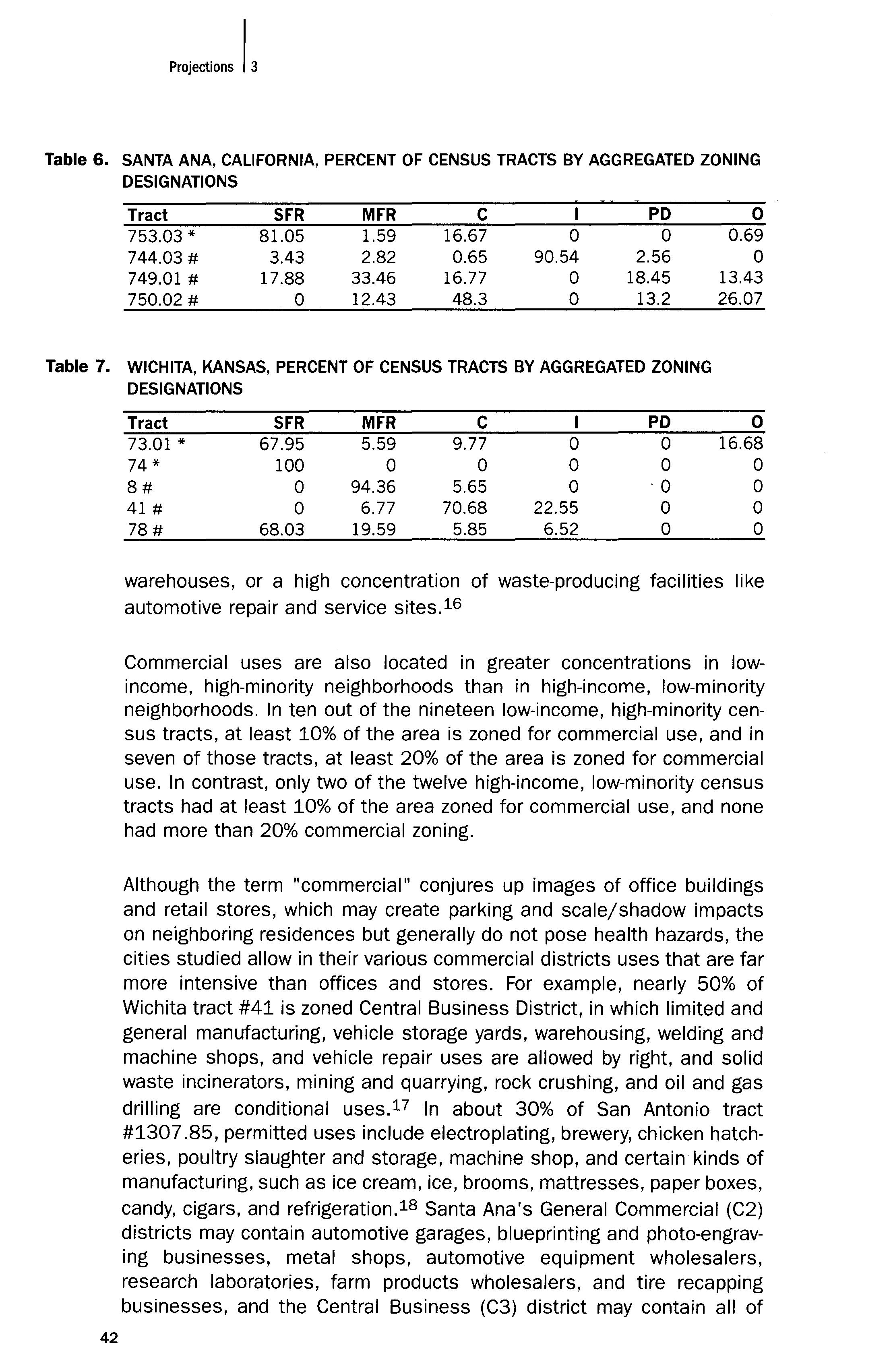
42
Table 8. INDUSTRIAL ZONING BY CENSUS TRACTS
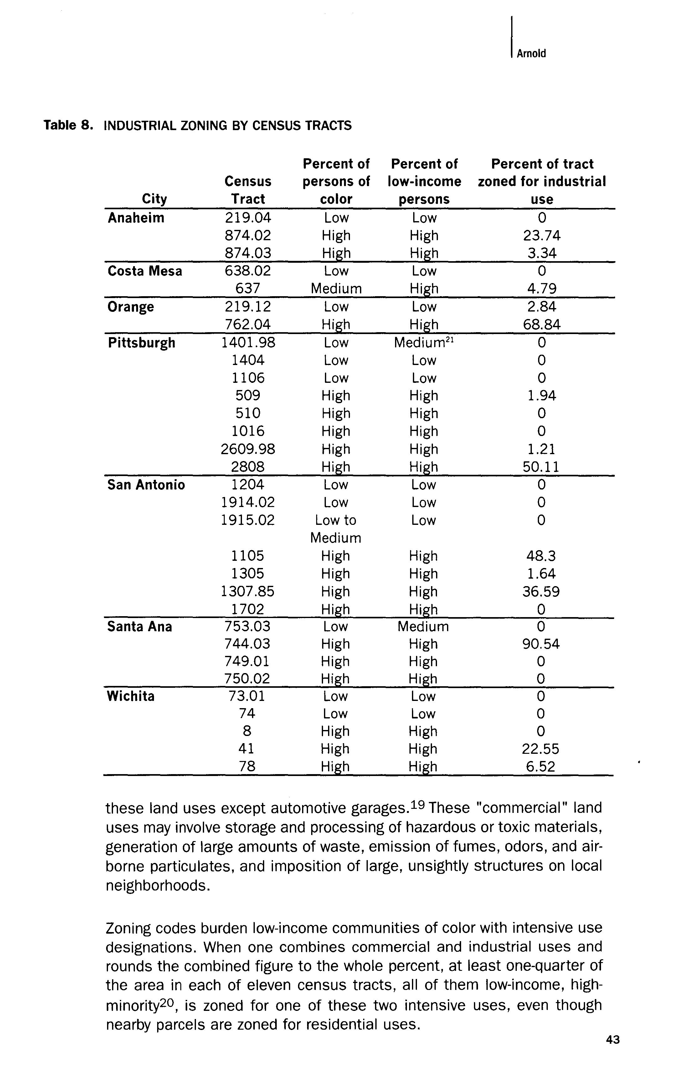
Percent of Percent of Percent of tract Census persons of low-income zoned for industrial City Tract color persons use
Anaheim 219.04 Low Low 0 874.02 High High 23.74 874.03 High High 3.34
Costa Mesa 638.02 Low Low 0 637 Medium High 4.79
Orange 219.12 Low Low 2.84 762.04 High High 68.84
Pittsburgh 1401.98 Low Medium 21 0 1404 Low Low 0 1106 Low Low 0 509 High High 1.94 510 High High 0 1016 High High 0 2609.98 High High 1.21 2808 High High 50.11
San Antonio 1204 Low Low 0 1914.02 Low Low 0 1915.02 Low to Low 0 Medium 1105 High High 48.3 1305 High High 1.64 1307.85 High High 36.59 1702 High High 0
Santa Ana 753.03 Low Medium 0 744.03 High High 90.54 749.01 High High 0 750.02 High High 0 Wichita 73.01 Low Low 0 74 Low Low 0 8 High High 0 41 High High 22.55 78 High High 6.52
these land uses except automotive garages. 19 These "commercial" land uses may involve storage and processing of hazardous or toxic materials, generation of large amounts of waste, emission of fumes, odors, and airborne particulates, and imposition of large, unsightly structures on local neighborhoods.
Zoning codes burden low-income communities of color with intensive use designations. When one combines commercial and industrial uses and rounds the combined figure to the whole percent, at least one-quarter of the area in each of eleven census tracts, all of them low-income, highminority20, is zoned for one of these two intensive uses, even though nearby parcels are zoned for residential uses.
I.mold
43
On the other hand, high-income, low-minority neighborhoods are the beneficiaries of single-family residential zoning and open-space zoning. Over 75% of the area in each of six high-income, low-minority tracts studied is zoned for single-family residences. If open space, a country club, and a private university (with significant open space) are included with singlefamily residential zoning, eleven of the twelve high-income, low-minority tracts have more than 75% of their respective areas zoned for these lowintensity land uses. The remaining tract, Costa Mesa #638.02, has more than 75% of the tract zoned for low-intensity land uses if the definition of low-intensity land uses includes not only single-family residences but also a private school, a post office, a fire station, and parks, all of which are highly compatible with single-family residential uses and are rarely, if ever, considered LULUs. In other words, all of the high-income, low-minority tracts have at least three-quarters of the total land uses in each tract designated as non-intensive land uses.
In contrast, the only low-income, high-minority census tract with more than 75% of the area zoned for single-family residential or open space uses is Pittsburgh census tract #2609.98 one tract out of nineteen. Although zoning for single-family residences or open space may preclude affordable housing needed by low-income people, the contrast in zoning patterns highlights the disparate impact of zoning designations on lowincome people of color.
Caveats + the Call for Further Studies
The data presented here simply show that land use regulatory patterns are not evenly distributed in seven cities between high-income white neighborhoods and low-income minority neighborhoods. A greater percentage of low-income high-minority neighborhoods are zoned for commercial and industrial uses, which are more intensive than residential. Readers should take care not to read more into the study than it provides.
The study does not address whether race or income is more important in the uneven distribution of land use regulation (Been & Gupta, 1997, pp. 4-5; Cole, 1992, pp. 622-630; Mohai & Bryant, 1992, p. 926). It does not attempt to isolate the race and income variables, and statistically correlate the results to either. Nor does it compare high-income white tracts with high-income minority tracts, low-income white tracts with low-income minority tracts, high-income minority tracts with low-income minority tracts, or highincome white tracts with low-income white tracts. And it certainly does not examine the land use patterns of middle-class tracts or moderately mixed-race tracts.
The study does not attempt to correlate zoning patterns with the presence of any particular LULUs or environmental hazards. It is possible that a census tract with significant industrial and commercial zoning could
44 Proj."u,"S I,
have no hazardous waste sites, for example. It is also possible that a census tract that is zoned primarily single-family residential could contain a major LULU, like a solid waste dump. These scenarios would probably be rare, and the neighborhoods with more intensive land uses would likely have more LULUs or environmental hazards (Bullard, 1984, 1987, 1995; Moore & Head, 1994). However, this study does not address the issue.
This study is not a longitudinal study (Been, 1994, pp. 1384-1385). It does not analyze when the current zoning patterns emerged, if and how zoning patterns changed over time, and how the racial and class composition of the census tracts changed over time. In other words, we do not know if the cities engaged in expulsive zoning by changing the zoning to permit intensive uses in low-income, minority neighborhoods (Rabin, 1990, p. 101) or if low-income, minority people moved to industrial or mixed-use neighborhoods because of cheaper housing costs, residential segregation, discrimination in private markets, proximity to work, or similar reasons (Been, 1994, p. 1385).
The study does not attempt to identify causes of the inequitable distributions of land use regulation. The possibilities are far-ranging: intentional discrimination by government decision makers, institutional discrimination embedded in the land use regulatory system, market forces, personal choices about priorities and values, lack of political power or resources, or (most likely) some complex and variable combination of many or all of these. Land use patterns are built on dozens or even hundreds of decisions both public and private made over a long period of time as a result of the interaction of various political, SOCial, and economic forces. The failure to isolate one or more causes does not preclude identification of a distributional problem or attempts by neighborhood groups and environmental justice activists to change existing land use patterns.
Finally, this study does not establish a national pattern. The number of cities studied, seven, is simply too small to prove that zoning in the United States is inequitable with respect to race and class. Furthermore, it is difficult to compare zoning in a census tract in one city with zoning in a census tract in another city, because the zoning is a result of decisions made by local land use regulatory authorities, which differ from city to city. In fact, this study shows that San Antonio zoned census tract #78 primarily single-family residential with a small amount of multi-family residential and a significant amount of com-mercial zoning, whereas Wichita zoned census tract #8 almost entirely multi-family residential with a little commercial zoning, and Orange has a large amount of industrial zoning in census tract #762.04. All of these census tracts are low-income communities of color. Therefore, land use regulation does not inevitably lead to high levels of commercial and industrial zoning in low-income and minority neighborhoods. Instead, comparisons must be between census
IArnold
45
tracts within each city, and a national trend would emerge only if a significant number of cities have inequitable zoning distributions.
Perhaps most importantly, national trends are only marginally relevant to addressing overly intensive zoning (or expulsive zoning) of low-income communities of color. Instead, the existing patterns and residents' concerns and land use goals are inherently local (indeed, specific to the neighborhood in question) and the regulatory authority is local. Changes will occur locality by locality, neighborhood by neighborhood, and not at a national level.
Study of the race and class distribution of land use regulatory patterns is only in its infancy. Research should go in two somewhat divergent directions simultaneously to fill the knowledge gap. One direction is toward more comprehensive and more rigorous statistical studies of the distribution of zoning in many different types of census tracts in many different cities. These studies would validate the findings of this study across a broader sample of cities than the seven selected here. These studies could also establish which variables correlate most closely to various distributional patterns. Some of the variables that should be analyzed are race, median household income, percentage of tract residents below the poverty level, the degree of political participation among census tract residents, geographic and natural characteristics of the tracts, type of land use regulatory system, historical development patterns, size of city, whether suburban development is within the city's political boundaries or within separate political (and therefore zoning) jurisdictions, the city-wide percentage of minorities and low-income people, and the citywide percentage of minority and low-income voters.
A second direction for empirical research on zoning distribution is toward more detail-rich, longitudinal, qualitative case studies of land use histories of specific neighborhoods. These studies would identify how zoning for neighborhoods changed over time, how actual land uses and development in the neighborhoods changed over time, and what factors and forces influenced each. For example, studies of two communities of color that have been zoned for industrial uses reveal very different histories. East Austin, Texas, was planned in 1928 to be a "negro district" and to contain most of the city of Austin's indus-trial zoning, which was reflected in Austin's first zoning map in 1931. Local residents now seek rezoning to eliminate the industrial uses (Greenberger, 1997). However, the Logan neighborhood of Santa Ana, California, was settled and developed as a primarily Mexican-American residential neighborhood and was zoned for residential use until 1929. When the Santa Fe Railroad was put through Santa Ana in the late 1920s, the neighborhood was mostly rezoned to heavy industrial (M-2) but remained almost exclusively residential until 1953. In 1953, the zoning code prohibited new residential development in the Logan neighborhood, which led to a mixing of industrial and com-
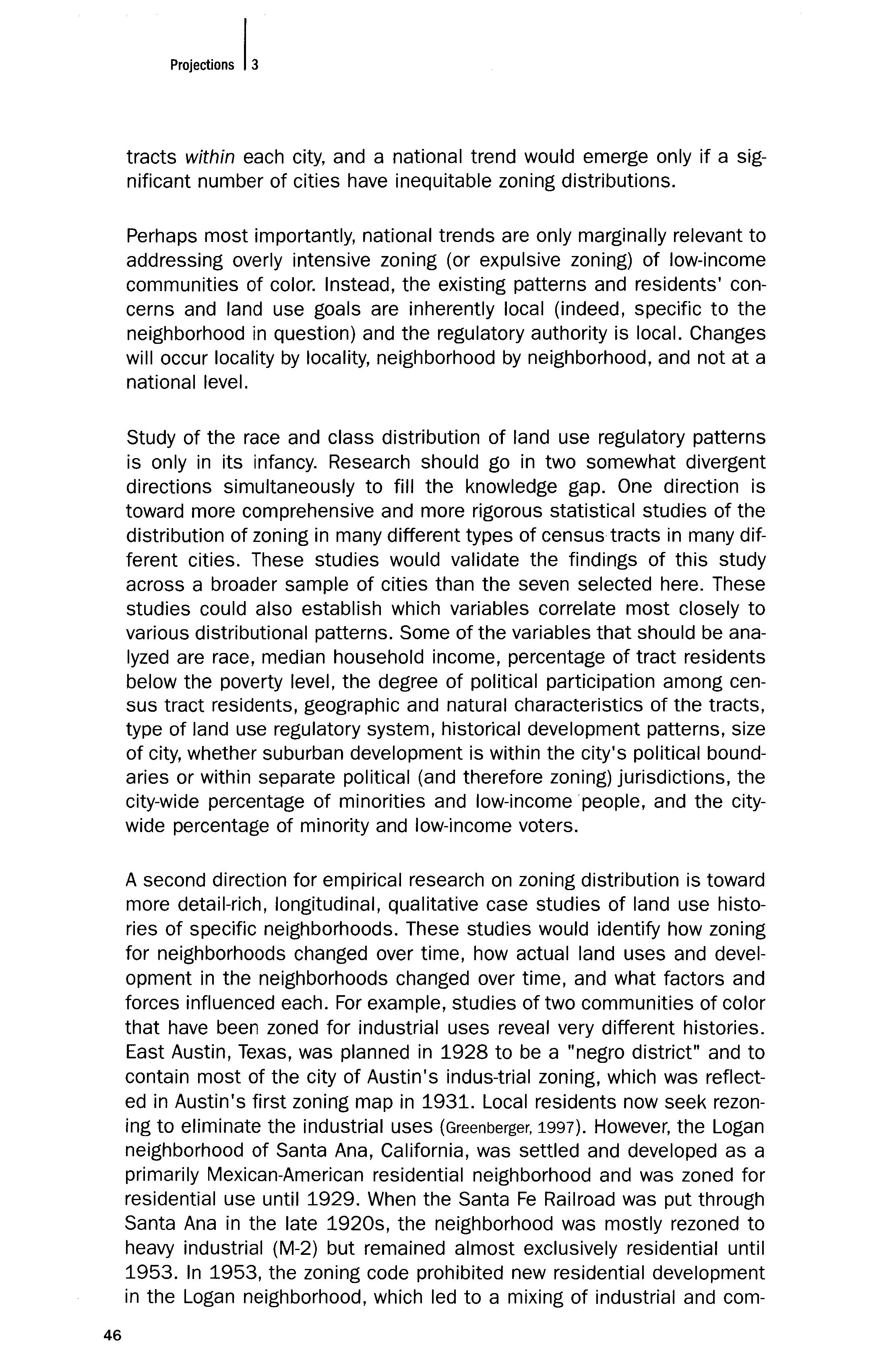
46
mercial uses among the residential uses by the late 1970s. During the 1980s, zoning was determined parcel by parcel through a conditional use permit process until local residents asked for elimination of the zoning uncertainty associated with parcel-by-parcel decisions. Now, 59% of all landowners and 49% of all residential landowners prefer their properties to be zoned industrial (City of Santa Ana, 1998).
The case study method accounts for variations in land use decisions from locality to locality, and should include a synthesis of generalizable theories and the empirical context of specific examples. We are likely to understand the causes of environmental injustice only by engaging in context-specific, detail-rich, longitudinal (i.e., over time) case studies that document all the factors that have gone into the existence of environmental hazards and LULUs in particular neighborhoods. The causes are more complex, interrelated, and perhaps insidious than aggregate data studies can show.22
Nevertheless, this empirical study demonstrates that inequitable land use regulatory patterns exist. The current conceptions of environmental justice do not effectively address these patterns.
LAND USE PLANNING + REGULATION: ANOTHER VISION OF ENVIRONMENTAL JUSTICE
Planning Model vs. Oppositional Model
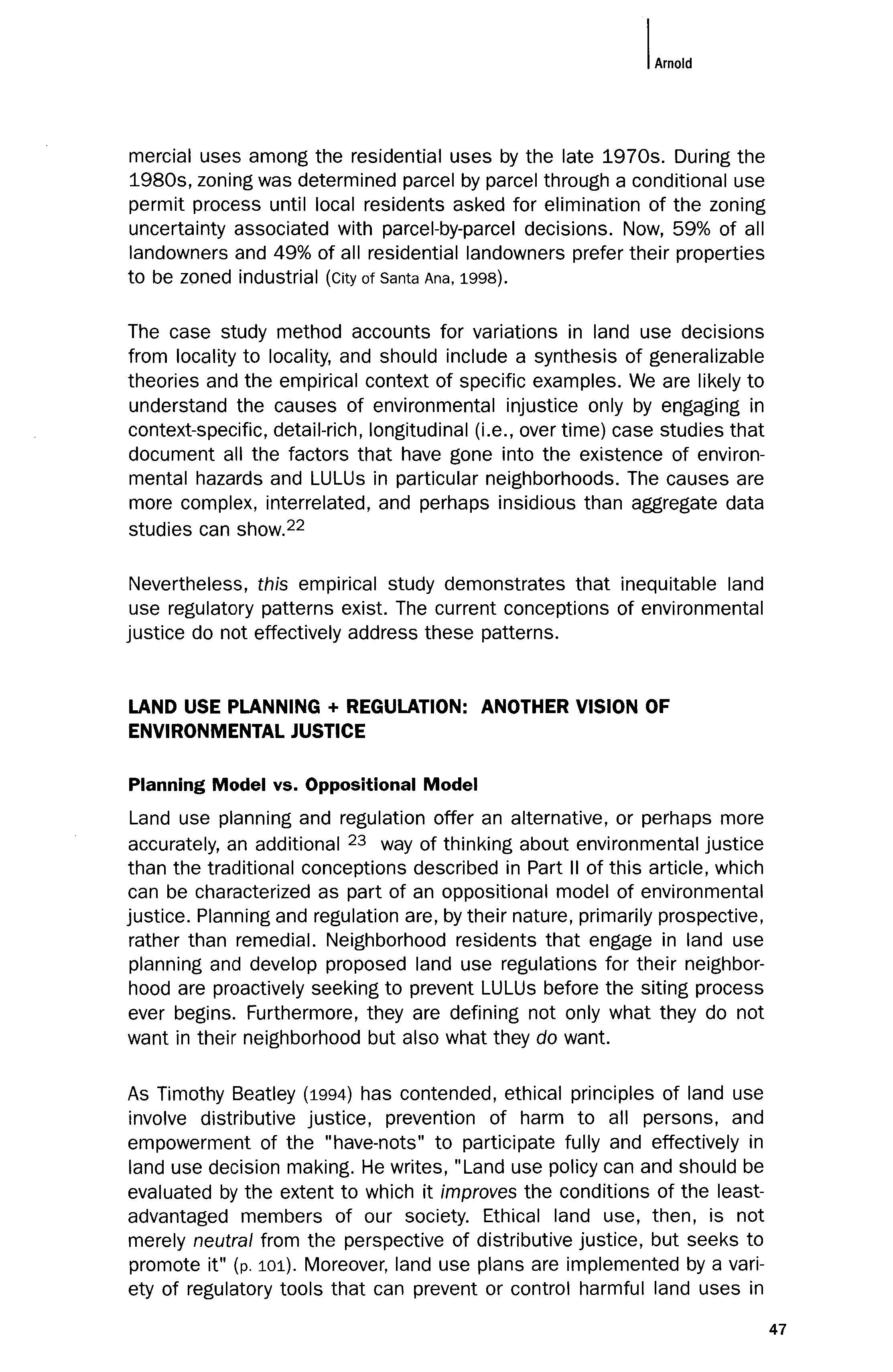
Land use planning and regulation offer an alternative, or perhaps more accurately, an additional 23 way of thinking about environmental justice than the traditional conceptions described in Part II of this article, which can be characterized as part of an oppositional model of environmental justice. Planning and regulation are, by their nature, primarily prospective, rather than remedial. Neighborhood residents that engage in land use planning and develop proposed land use regulations for their neighborhood are proactively seeking to prevent LULUs before the Siting process ever begins. Furthermore, they are defining not only what they do not want in their neighborhood but also what they do want.
As Timothy Beatley (1994) has contended, ethical principles of land use involve distributive justice, prevention of harm to all persons, and empowerment of the "have-nots" to participate fully and effectively in land use decision making. He writes, "Land use policy can and should be evaluated by the extent to which it improves the conditions of the leastadvantaged members of our society. Ethical land use, then, is not merely neutral from the perspective of distributive justice, but seeks to promote it" (p. 101). Moreover, land use plans are implemented by a variety of regulatory tools that can prevent or control harmful land uses in
IArnold
47
CHARACTERISTICS OF TWO MODELS OF ENVIRONMENTAL
Opposition Model Reactive Retrospective Remedial Outsiders Fighting power Subordinated Victims Exclusive
JUSTICE
Planning Model Proactive Prospective Visionary Participants Exercising power Empowered Decision makers Inclusive
low-income neighborhoods of color. In the pursuit of land use justice under a planning model, neighborhood residents, planners, and decision makers can mitigate environmental impacts by using tools like: zoning map amendments (i.e., rezoning or downzoning parcels of land from more intensive uses to less intensive uses); zoning text amendments (i.e., revising the uses permitted in particular zones or adding particular restrictions on permitted uses); regulation of adverse impacts from certain conditionally allowed uses via conditional use permits (which can be denied or heavily conditioned); buffer zones; overlay zones; performance standards; and exactions (Arnold, 1998, pp. 105-124).
The planning and opposition models of environmental justice share some characteristics. Both are largely concerned with questions of fairness (however defined) and goals of achieving safe and healthy communities. Both involve empirical, political, legal, environmental, and economic factors. Both attempt to prevent environmental hazards and LULUs in low-income and minority neighborhoods, albeit in different ways. And both are struggles for grassroots participation in policymaking and in political, economic, and legal decisions that affect these neighborhoods.
The models also differ in some important ways. In the opposition model, grassroots activists react to existing LULUs or proposed sitings. In many cases, they may seek remedies for past or ongoing harms or government and corporate decisions that pose the risk of harm. Thus, the opposition model is largely reactive, retrospective, and remedial, although perhaps necessarily so. In the planning model, local residents develop land use plans and regulations that either address broader problems than a single LULU or reflect goals for future land use patterns in the neighborhood. To some extent, these plans and regulations capture an element of the community's self-identity (e.g., a high-density community of affordable housing; an historic neighborhood of single-family residences and small retail businesses; a neighborhood of single- and multi-family housing with many small parks and playgrounds and few through-streets; an area in which industrial activities remain on the east side of the river). These plans and regulations also are in place to govern future land use decisions, including proposals for LULU sitings. In these ways, the planning model is proactive, prospective, and visionary.
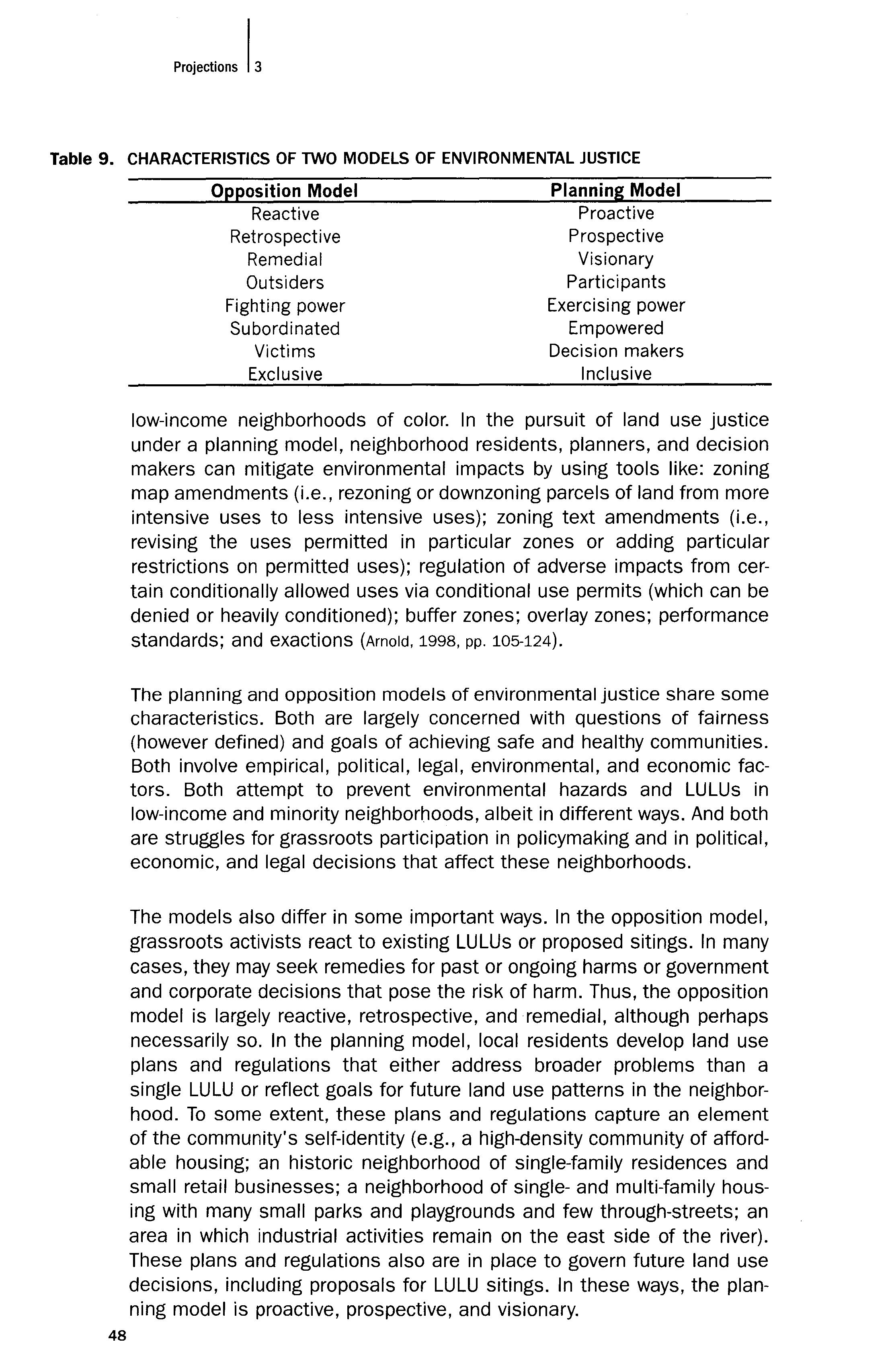
Project'''' I,
Table 9.
48
Opponents of existing or proposed LULUs often are political outsiders, entering the decision making process after relationships have been established between the facility owner or operator and government officials. Theirs is the struggle of people without power who are taking on and fighting established exercises of power. Some environmental justice activists reject government decision making, economic markets, and the legal system as inherently subordinating and victimizing the poor and minorities. In many ways, low-income people and people of color who seek to influence land use planning and regulation start out similarly struggling against the powerful. Their goal, however, is to exercise power within the existing land use regulatory system. They want to participate in the process, empowered by their definition of land use goals and, hopefully, by successful implementation of these goals through zoning and other regulations. They want to be participants at the land use negotiating table in matters that concern them, along with government officials, developers, property owners, environmentalists, and other interested people and groups. They want to serve on advisory boards, zoning commissions and boards of appeal, city councils, and other decision making bodies.
Finally, the opposition model identifies and seeks to exclude harmful activities and LULUs. The planning model identifies and seeks to allow (i.e., include) desirable land uses. The contrasts between these two models are summarized below:
Strategic Advantages, Efficacy + the Public Good
Land use planning and regulation offer, several advantages for achieving environmental justice goals. First, an owner or operator of a prospective LULU would have much more difficulty obtaining approval for siting the LULU in a minority or low-income neighborhood, if the comprehensive plan and zoning ordinances prohibited the LULU in that neighborhood than if they allowed the LULU, either by right or conditionally. Assume that a waste company wants to locate a hazardous waste incinerator in a lowincome Hispanic neighborhood. If the city zoning code prohibits hazardous waste incinerators in every zone except 1-3, and the zoning map does not designate any land in the target neighborhood as 1-3, the waste company will need a zoning amendment, as well as use-specific environmental permits. If the city's comprehensive plan provides for nonindustrial uses only in the neighborhood or explicitly states that waste facilities are not appropriate for that neighborhood, the waste company also will need an amendment to the comprehensive plan. The waste company nonetheless might have enough political and economic power to obtain all the needed approvals, but it will face several obstacles. The zoning code text and map and the comprehensive plan will create a presumption that the hazardous waste incinerator is not appropriate for the neighborhood. This presumption will take on a certain legal and political reality. The waste company will have to expend more political capital to
IArnold
49
overcome the presumption. The neighbors will have more opportunities to defeat the incinerator. Not only might the federal or state environmental agencies deny the permits, but the local land use authority, perhaps more attentive to local neighborhood concerns, might deny the land use approvals. Furthermore, the neighbors will have more government approvals to challenge in litigation. If each approval is necessary to the siting of the project, and a court were to hold any approval to be invalid, the project would fail. The neighbors can bring land use claims, as well as civil rights and environmental law claims, to challenge any objectionable land use approvals. For example, they can argue that rezoning to allow the incinerator is inconsistent with the comprehensive plan, irrationally allows a use that is incompatible with surrounding uses, constitutes spot zoning, and violates procedural requirements. When neighborhoods engage in land use planning and regulation, they create the rules with which prospective LULUs must comply, rather than merely reacting to specific LULU siting proposals that have already surfaced and obtained a certain amount of legitimacy before opposition can arise. These preestablished rules can make LULUs less likely to receive approval and challenges to any such approvals more likely to be successful.
Second, land use planning and regulation create greater certainty about what land uses will or will not be allowed in a neighborhood. When local land use regulations allow LULUs, either by right or conditionally, neighborhood residents face uncertainty about whether or not their neighborhood will be the object of a LULU siting proposal (or a proposal to site another LULU in their neighborhood if they already have one or more). Once a proposal has been made, neighborhood residents face the further uncertainty about whether or not they will be successful in defeating the proposal. Similarly, the owner or operator faces uncertainty about whether local residents will attempt to defeat the project as inappropriate for the neighborhood even though the local land use regulations permit it and the owner or operator has invested significant amounts in that specific site proposal. Both sides have significant economic costs (i.e., inefficiency), psychological costs (i.e., anxiety), and relational costs (i.e., suspicion and animosity) resulting from uncertainty about the propriety of the LULU in the neighborhood. However, if local residents have been involved in land use planning and development of regulations for their neighborhood and have carefully identified what uses are appropriate for different areas of their neighborhood, the level of certainty increases substantially. Proponents of LULUs may nonetheless seek amendments to or relief from applicable land use prohibitions and neighborhood residents may nonetheless oppose LULUs permitted by the regulations. But in most circumstances, the content of the land use plans and regulations, when developed with meaningful neighborhood participation, provide generally reliable information on which both sides can base decisions. This information fosters efficiency, comfort, and trust.
50 Pmi''"'"' 13
Third, land use planning and regulation improve the community's capacity to achieve its goals. Typically, members of neighborhoods have community goals that extend far beyond excluding a particular LULU from the neighborhood. They often have goals about parks and other recreational uses, open space, traffic patterns and safety, availability of grocery stores or medical facilities, maintenance of property and cleanup of nuisances, public infrastructure like streets, sidewalks, and drainage, public areas or commons, social or cultural centers, historic preservation, community identity, economic development, public transportation, and many other matters. Land use plans contain these goals, and land use regulations facilitate efforts to reach the goals by defining the permissible land uses in the neighborhood (so & Getzels, 1988). Although some local neighborhoods may overwhelmingly seek residential zoning, others might lack consensus or might embrace industrial zoning as consistent with their vision of the neighborhood. Empowerment to define and seek land use goals is the objective.
Land use planning and regulation will not always preclude the siting of LULUs or include the need to oppose proposals or existing sites. However, communities that develop a healthy, proactive vision of their neighborhoods and enact that vision in land use regulations will more likely prevent LULUs and other environmental harms than if they had simply waited to react. The empirical evidence presented in this article shows a wide difference in zoning patterns between low-income communities of color and high-income white communities. Whether caused by intentional discrimination, institutional inequities, market forces, or some other factor(s), these disparities indicate that low-income people of color have very little effective input into the land use planning and regulatory process. They also suggest that environmental justice advocates may want to consider additional strategies that focus on community-based planning initiatives and zoning proposals.
Empowerment
As discussed in this article, a significant goal of the environmental justice movement is the empowerment of grassroots communities of low-income people of color. How successful, as a practical matter, will grassroots neighborhood groups be in changing land use patterns in low-income communities of color? There is reason for a mix of sober realism and thoughtful optimism.
At the most practical level, residents of some, or perhaps many, lowincome and minority neighborhoods will encounter apathy, antipathy, or paternalistic cooptation by local planning staff and elected officials. Local government is likely to regard changes to existing industrial or commercial zoning as politically or fiscally inconvenient, especially when these
IArnold
51
uses cannot be relocated to higher-income, lower-minority areas without political conflict. Indeed, many local governments engage in "fiscal zoning," favoring industrial and commercial uses because these uses generate tax revenues without creating expensive demands for local services in the way that single-family residences do, particularly due to public school costs (Ellickson & Tarlock, 1981). However, single-family residential neighborhoods, particularly if occupied by upper-income people, are desirable for other reasons than a pure analysis of marginal costs and revenues would indicate. But cities and counties might offset the costs of these neighborhoods by reducing expenditures on older neighborhoods where industrial and commercial uses have intruded: generally lowincome and minority neighborhoods (p. 740). Therefore, fiscal zoning practices can have a double negative effect on low-income communities of color: 1} the attraction of industrial and commercial uses to those areas, and 2} pressures on local governments to decrease public spending on physical infrastructure, schools, and other public services in those areas.
In addition, owners of industrially or commercially zoned property will often oppose downzoning of those parcels, the imposition of additional controls via overlay districts or performance zoning, and demands of exactions. These landowners are likely to have financial and political capital to spend in seeking to defeat an environmental justice land use plan. The local community may not be united in its goals, and disagreement within the area could undermine strategies to allow only safe and healthy land uses compatible with local residences. In other words, some or all of a low-income minority neighborhood might embrace one or more LULUs or other intensive land uses, and this fact may be a political reality for opponents (Gover & Walker, 1992; Kass, 1997). Furthermore, development of a land use regulatory plan for a low-income neighborhood of color is likely to involve financial costs and volunteer effort, as well as sustained political activity in the form of organization, publicity, education, study, lobbying, electoral campaigning and voting, and perhaps even protest. Finally, the nature of the land use planning and regulatory model requires continual involvement in, and monitoring of, implementation. Developers, landowners, and LULU operators may seek conditional use permits, variances, and rezonings, among other changes or exceptions to whatever regulations the local residents have helped to shape. Failure of grassroots environmental justice groups to participate effectively in these subsequent government decisions could undo all that the initial land use strategy had achieved.
These practical concerns raise questions about the extent to which land use controls are inherently flawed. Some scholars imply that the combination of zoning's exclusionary nature and society's racism leads to segregation of races, exclusion of people of color from desirable areas, and placement of unwanted land uses in neighborhoods of color (i.e., expulsive zoning) (Dubin, 1993, pp. 741-744; Rabin, 1990, p. 101). Other scholars
52
I,
Proj,ello",
argue that zoning promotes balkanization by socioeconomic class and geography, resulting in suburban sprawl and protection of the economic interests of the development community (i.e., business interests, land developers, financial institutions, and the like) and/or suburban homeowners (Briffault, 1990; Davis, 1992; Frug, 1996). Zoning can also be seen as a tool of parochial local interests that want to keep socially necessary land uses out of their communities, in other words, a tool of NIMBY-ism the worst of localism and pluralism, an impediment to the larger public good (Delogu, 1981). According to some, land use controls inappropriately interfere with, or even supplant, the efficient workings of private markets and privately developed norms and agreements about land use (Ellickson, 1973; Kmiec, 1981). Others would argue that land use regulations are means for government capture of public benefits or power at the expense of private property or liberty (Epstein, 1985; Malloy, 1991; Siegan, 1997).
These critiques, in turn, raise questions about how local land use decisions are made. In other words, will low-income and minority neighborhoods have a fair and effective opportunity to influence the land use policies that affect them? The difficulty in answering this question stems from the lack of a single, coherent, comprehensive theory of local policymaking.24
If land use decisions are controlled primarily by local elites, who serve the private economic interests of either the development and business community or upper- and middle-income homeowners in areas zoned primarily single-family residential (i.e., suburban and suburban-like communities) (Davis, 1992; Feagin, 1990; Feagin & Parker, 1990; Judd, 1984), low-income and minority people will likely remain "outsiders" with very little real influence over land use decisions. These decisions will continue to protect high-income, low-minority neighborhoods from non-residential uses, while catering to industrial and commercial interests by placing those activities in the "subordinated" low-income and minority neighborhoods. Similarly, if local land use decisions typically reflect persistent societal racism (Dubin, 1993, p. 741; Ford, 1994, p. 1843; Rabin, 1990, p. 101), minority neighborhoods will continue to suffer a higher proportion of LULUs and intensive zoning patterns. According to this theory, local officials intentionally or unconsciously select these communities for greater burdens or tolerate private and institutional forces that exacerbate inequalities.
If the primary model of land use decision making is interest group plu c ralism (Burke, 1979; Mandelker & Tarlock, 1992), grassroots groups from low-income and minority communities will fare much better than if only elite interests have captured the decision making process. Grassroots success will depend on the groups' abilities to organize, identify goals and strategies, exert pressure, persist in participating in land use decisions, and bargain effectively with other interest groups and government officials to obtain political benefits. There are, however, two normative
IArnold
53
sides to interest group pluralism. One view celebrates the diversity of interests that are represented in a blatantly political process of "demanding, wrangling, and influencing," and asserts that the roar of many groups seeking policies which benefit their members' interests reflects overall citizen preferences and prevents any single group from obtaining too much power (Burke, 1979, p. 27). The other view is aghast at the "capture" of public policy making and policy implementing bodies by well-organized special interest groups (Mandelker & Tarlock, 1992). It observes the vast differences in power and effectiveness among groups and the tendency for policy outcomes that serve private interests to the detriment of the collective good, whether that collective good is defined in terms of equity or efficiency or both (p. 37). Although low-income and minority neighborhood groups seeking their visions of good land use policy will certainly add to the range of interests represented, they could find themselves outmatched in political and economic power by well-organized industrial and commercial interests. Furthermore, to the extent that they buy into pluralism as a dominant model, they may lose their "moral voice": their claims that changes in zoning patterns in their neighborhoods reflect just policy (i.e., are the "right" result), instead of merely the preferences of yet another group.
Civic republican theory suggests that local policymaking is or should be a deliberative public discourse about the common good and a participatory process of developing civic virtue (Elkin, 1987; Michelman, 1988; Viterritti, 1996). Alternatively, local land use policies could be seen as the result of a negotiation "game," either between the developer and government officials, or among a range of interested parties, including the developer, the property owner(s) and possessor(s) (if different from the developer), neighbors of various types, environmental groups, various government agencies (perhaps with competing or coextensive jurisdiction), and even scientific and legal professionals (Karkkainen, 1994).
One possible reason for competing theories about land use politics and decision making is that each explains some portion of a complex and variable reality. The process of land use regulation inevitably involves some type(s) of negotiation. But the identity and number of participants, their relative bargaining strength, their actual influence, whether the negotiation focuses more on positions or interests or principles, the role of external factors, the economic efficiency of the process (transaction costs) and outcomes (Pareto optimality), the fairness of the process (procedural justice) and outcomes (distributive justice), the impact on civic virtue, and other factors will likely vary widely from locality to locality and from decision to decision. Thus, it seems doubtful that the land use regulatory process inherently or inevitably excludes low-income and minority communities from effective participation.
Despite the critiques of land use regulation, the land use model remains
54
a useful approach to addressing environmental injustice and the goals of low-income and minority communities. First, land use controls even if they could be characterized as flawed are here to stay. Zoning and similar regulatory controls over land use are widely used in the United States, and there is little evidence that local governments pay much attention to academic criticisms of the institution of land use regulation (Cappel, 1991; Karkkainen, 1994). As this article demonstrates, however, lowincome neighborhoods of color do not enjoy the same zoning protections and benefits that high-income, non-minority neighborhoods enjoy. Unless courts correct these inequities (Dubin, 1993, pp. 782-800), a process which seems highly unlikely (Arnold, 1998, pp. 50-55), the primary means of change will be political activity attempting to influence land use decisions and zoning patterns.
Second, land use regulation serves several important functions, including protection of neighbors against harmful or noxious activities on nearby land; comprehensive, area-wide, coordinated planning of land uses and development patterns; protection of private property values from the impact of neighboring uses; prevention of development from placing greater burdens on public funds for infrastructure and services than the development generates in tax revenues; and protection of collective rights and interests in the character of the neighborhood (Fischel, 1985; Karkkainen, 1994; Larson, 1995). In addition, political pressures and the options of voice (participation) or exit (relocating to another jurisdiction) are effective constraints on the potential for abuse in the arena of land use regulation (Fischel, 1995). Involvement of low-income and minority neighborhood residents in developing and implementing land use policies enhances these various goals or values of the land use regulatory system.
Third, if, as Cole (1992) has argued, environmental justice is an issue of power, the poor and people of color should be seeking power wherever it is exercised, including in the land use decisions that shape both the quality of their neighborhoods and their exposure to harmful or unwanted activities and pollutants. Furthermore, they will be able to exercise power more effectively with respect to land use decisions than with respect to environmental permitting decisions, because land use decisions are made at the local level where grassroots groups have greater access (Arnold, 1991; Thompson, 1996) and decisions are less scientifically and legally technical. Layperson input tends to shape local land use regulation more than it shapes national environmental regulation.
Most importantly, not only does land use planning and regulation theoretically embrace neighborhood-based citizen participation (Burke, 1979; Clay & Hollister, 1983; Fagence, 1977; Karkkainen, 1994; Mandelker & Tarlock, 1992) but empirical evidence shows that citizen participation can make a difference (Barrette, 1994; Conway, 1985; Gallagher, 1993; Gregory, 1994; Martelle, 1997), including
IArnold
55
in the arena of land use regulation and environmental justice. Earlyexamples of environmental justice groups seeking local land use policies suggest that low-income and minority neighborhood residents can effectively organize, exercise power, make their voices heard, and influence policies about zoning and land use issues that affect them. Despite political and legal limitations, environmental justice groups actively seek and obtain changes to zoning laws to reflect the goals of neighborhood residents and a more equitable distribution of land use patterns.
CONCLUSION
There are no easy answers or quick fixes to environmental injustice. It is a complex problem with empirical, political, legal, environmental, and economic dimensions. One model of environmental justice features opposition to existing or proposed LULUs and environmental hazards in lowincome and minority communities. However, another model, presented in this article, calls for these communities to become involved in land use planning and regulation. Through comprehensive planning, rezoning of inner-city neighborhoods, use of flexible zoning techniques and exactions, and political involvement in the shaping and negotiating of local land use policies, residents of low-income neighborhoods and neighborhoods of color can proactively define their visions for healthy communities. They also can seek to prevent would-be polluters and operators of LULUs and other intensive land uses from selecting sites in their communities initially. In the event that they still have to oppose siting proposals or seek changes to existing facilities, they have a stronger case that public policy supports their position. Local residents also may choose to allow or encourage development that meets their economic, social, and environmental goals. Land use planning and regulation foster choice, self-determination, and self-definition for local neighborhoods, not paternalism that insists that there is a single correct environmental justice goal. 25
Acknowledgments
The author is grateful for the helpful comments of Morton Gitelman, Susanna Kim, Guadalupe Luna, Kenneth Manaster, and Tracy ArnoldChapman; the research assistance of Stephen Cassidy, Scott Burkhalter, Michael Bailey, Darren Stroud, Randy Weichbrodt, Chris Erwin, Shirley Arnold, and Judy Gray; and the resourcefulness of the staffs of the Chapman University Law Library, the Crown Law Library at Stanford Law School, and the Government Documents Library, California State University, Fullerton.
56
REFERENCES
Anderson, A. B., Anderton, D.L., & Oakes, J.M. (1994, July). Environmental equity: Evaluating TSDF siting over the past two decades. Waste Age, p. 83.
Arnold, C. A. (1991). Conserving habitats and building habitats: The emerging impact of the endangered species act on land use development. Stanford Environmental Law Journal, 10, 1-36.
Arnold, C. A. (1998). Planning milagros: Environmental justice and land use regulation. Denver University Law Review, 76, p. 1.
Arnold, C. A. (in press). Environmental justice: Lessons learned. Environmental Law Institute, forthcoming.
Baden, B., & Coursey, D. (1997). The locality of waste sites within the city of Chicago: A demographic, social, and economic analysis. The Irving B. Harris Graduate School of Public Policy Studies, University of Chicago Working Paper Series 97-2.
Barrette, M. (1994, March). City of Anaheim: Avon-Dakota-Eton neighborhood association. Planning, p. 16.
Been, V. (1993). What's fairness got to do with it? Environmental justice and the siting of locally undesirable land uses. Cornell Law Review, 78, 1001.
Been, V. (1994). Locally undesirable land uses in minority neighborhoods: Disproportionate siting or market dynamics? Yale Law Journal, 103, 1383.
Been, V. (1995). Analyzing evidence of environmental justice. Journal of Land Use and Environmental Law, 11, 1.
Been, V., & Gupta, F. (1997). Coming to the nuisance or going to the barrios? A longitudinal analysis of environmental justice claims. Ecology Law Quarterly, 24, 1.
Binder, D. (1995). Index of environmental justice cases. Urban Lawyer, 27, 163.
Briffault, R. (1990). Our localism: Part I The structure.of local government law. Columbia Law Review, 90, 1,3-5.
Bullard, R. D. (1984). Endangered environs: The price of unplanned growth in boomtown Houston. California SOCiologist, 17, 85.
Bullard, R. D. (1987). Invisible Houston: The black experience in boom and bust. College Station: Texas A&M University Press.
Bullard, R. D. (1990). Dumping in Dixie: Race, class, and environmental quality. Boulder: Westview Press.
Bullard, R. D. (Ed.) (1993). Confronting environmental racism: Voices from the grassroots. Boston: South End Press.
Bullard, R. D. (1995). ReSidential segregation and urban quality of life. In B. Bryant (Ed.), Environmental justice: Issues, policies, and solutions. Washington, DC: Island Press.
Burke, E. M. (1979). A participatory approach to urban planning. Human Sciences Press. Cappel, A.J. (1991). A walk along willows: Patterns of land use coordination in pre-zoning New Haven. Yale Law Journal, 101,617.
City of Austin Planning, Environmental and Conservation Services Department (1997). East Austin land use/zoning report. <http://www.ci.austin.tx.us/landuse/ea_text.htm> (accessed October 21, 1998; last modified March 6, 1997).
City of Santa Ana (1998). Logan neighborhood land use and zoning report, pp. 1-2, 5-6.
Clay, P. L., & Hollister, R. M. (Eds.) (1983). Neighborhood policy and planning. Lexington, MA: Lexington Books.
Cole, L. (1992). Empowerment as the key to environmental protection: The need for environmental poverty law. Ecology Law Quarterly, 19, 619.
I Arnold
57
Cole, L. (1994). Environmental justice litigation: Another stone in David's sling. Fordham Urban Law Journal, 21, 523.
Cole, L., & Foster, S. R. (2001). From the ground up: Environmental racism and the rise of the environmental justice movement. New York: New York University Press.
Collin, R. W. (1992). Environmental equity: A law and planning approach to environmental racism. Virginia Environmental Law Journal, 11, 495-538.
Collin, R. W. (1994). Review of the legal literature on environmental racism, environmental equity, and environmental justice. Journal of Environmental Law and Litigation, 9, 121.
Colopy, J. H. (1994). The road less traveled: Pursuing environmental justice through Title VI of the Civil Rights Act of 1964. Stanford Environmental Law Journal, 13, 125.
Conway, M. M. (1985). Political participation in the United States. Washington, DC: CQ Press.
Council on Environmental Quality (1974). Fifth Annual Report. Reprinted in R.R. Wright and M. Gitelman (Eds.), Cases and Materials on Land Use (1997, pp. 776-778). St. Paul, MN: West Publishing Company.
Davis, M. (1992). City of quartz: Excavating the future in Los Angeles. London: Pimlico. Delogu, O. E. (1981). The dilemma of local land use control: Power without responsibility. Maine Law Review, 33, 15, 16-20.
Dubin, J. C. (1993). From junkyards to gentrification: Explicating a right to protective zoning in low-income communities of color. Minnesota Law Review, 77, 739-744.
Elkin, S. L. (1987). City and regime in the American republic. Chicago: University of Chicago Press.
Ellickson, R. C. (1973). Alternatives to zoning: Covenants, nuisance rules, and fines as land use controls. University of Chicago Law Review, 40, 682-687.
Ellickson, R. C. (1991). Order without law. Cambridge, MA: Harvard University Press. Ellickson, R. C., & Tarlock, A. D. (1981). Land use controls: Cases and materials. Gaithersburg: Aspen Law and Business.
Epstein, R. A. (1985). Takings. Cambridge, MA: Harvard University Press.
Fagence, M. (1977). Citizen participation in planning. New York: Pergamon Press.
Fahsbender, J. (1996). An analytical approach to defining the affected neighborhood in the environmental justice context. New York University Environmental Law Journal, 5, 120, 121, 131,138.
Feagin, J. R. (1990). Arenas of conflict: Zoning and land use reform in critical political-economic perspective. In C. M. Haar & J. S. Kayden (Eds.), Zoning and the American dream. Chicago: American Planning Association.
Feagin, J. R., & Parker, R. (1990). Building American cities: The urban real estate game. Englewood Cliffs, NJ: Prentice Hall College Division.
Fischel, W. A. (1985). The economics of zoning laws: A property rights approach to American land use controls. Baltimore: Johns Hopkins University Press.
Ford, R. T. (1994). The boundaries of race: Political geography in legal analysis. Harvard Law Review, 107, 1843.
Frug, J. (1996). The geography of community. Stanford Law Review, 48, 1047.
Gallagher, M. L. (1993, March). Gila River Indian community public participation program. Planning, p. 12.
Garreau, J. (1991). Edge city: Life on the new frontier. New York: Anchor Books.
Gauna, E. (1995). Federal environmental citizen provisions: Obstacles and incentives on the road to environmental justice. Ecology Law Quarterly, 22, 1.
Gauna, E. (1998). The environmental justice misfit: Public participation and the paradigm paradox. Stanford Environmental Law Journal, 17, 3.
58 Pmj.ctlo", 13
Gover, K., & Walker, J. L. (1992). Escaping environmental paternalism: One tribe's approach to developing a commercial waste disposal project in Indian country. University of Colorado Law Review, 63, 933, 936-942.
Greenberger, S. S. (1997, July 20). City's first zoning map plotted neighborhood of minorities' hazards. Austin American Statesman, p. A1.
Gregory, M. (1994, March). Champaign neighborhood wellness action plan. Planning, p. 14.
Haurwitz, R. K. M., Greenberger, S.S., Hiott, D., Moscoso, E., Trower, T., & South, J. (1997, July 20). An industrial chokehold: Toxic hazards abound in East Austin, and it's no coincidence. Austin American Statesman p. A1.
Inner City Press (2000). Environmental Justice Reporter, Report for October 30, 2000. <http://www.innercitypress.orgjejreport> (accessed November 2, 2000).
Inner City Press (2001). Environmental Justice Reporter, Report for June 11, 2001. <http://www.innercitypress.orgjejreport> (accessed March 5, 2002).
Jaffe, S. D. (1995). The market's response to environmental inequity: We have the solution, what's the problem. Virginia Environmental Law Journal, 14, 655.
Judd, D. R. (1984). The politics of American cities: Private power and public policy. Glenview, IL: Scott, Foresman.
Karkkainen, B. C. (1994). Zoning: A reply to the critics. Journal of Land Use and Environmental Litigation, 10, 45-81.
Kass, J. (1997, Sept. 4). Homes and shops at odds. Los Angeles Times, B3.
Kaswan, A. (1997). Environmental justice: Bridging the gap between environmental laws and justice. American University Law Review, 47, 221.
Kennedy, K. M. (1996). Local negotiations in hazardous waste incinerator permitting: A comparison of economic and communication models in four case studies. Ph.D. Dissertation, University of California at Berkeley.
Kmiec, D. W. (1981). Deregulating land use: An alternative free enterprise development system. University of Pennsylvania Law Review, 130, 28, 30-31.
Lambert, T., & Boerner, C. (1997). Environmental inequity; Economic causes, economic solutions. Yale Journal on Regulation, 14, 195.
Larson, J. E. (1995). Free markets deep in the heart of Texas. Georgetown Law Journal, 84, 179-235.
Lazarus, R. J. (1994). Pursuing "environmental justice": The distributional effects of environmental protection. Northwestern University Law Review, 87, 787.
Maantay, J. (2001, July 1). Zoning, equity, and public health. American Journal of Public Health, p. 1033.
Malloy, R. P. (1991). Planning for serfdom: Legal economic discourse and downtown development. Philadelphia: University of Pennsylvania Press.
Manaster, K. A. (1995). Environmental protection and justice: Readings and commentary on environmental law and practice. Cincinnati, OH: Anderson Publishing.
Mandelker, D. R., & Tarlock, A. D. (1992). Shifting the presumption of constitutionality in land-use law. Urban Lawyer, 24, 1-36.
Martelle, S. (1997, May 25). Don't tread on us: Community activists show how democracy works between votes. Los Angeles Times, p. B1.
Mata, R. (1994). Hazardous waste facilities and environmental equity: A proposed siting model. Fordham Urban Law Journal, 4, 375-391.
Maxwell, A., & Immergluck, D. (1997). Liquor/ining: Liquor store concentration and community development in lower-income Cook County neighborhoods. Chicago; Woodstock Institute.
Metzger, E. N. (1994). Driving the environmental justice movement forward: The need for a paternalistic approach. Case Western Reserve Law Review, 45, 379-388.
Michelman, F. (1988). Law's republic. Yale Law Journal, 97, 1503-1505.
IArnold
59
Mohai, P. (1995). The demographics of dumping revisited: Examining the impact of alternate methodologies in environmental justice research. Virginia Environmental Law Journal, 14, 615, 618-619.
Mohai, P., & Bryant, B. (1992). Environmental injustice: Weighing race and class as factors in the distribution of environmental hazards. University of Colorado Law Review, 63, 921.
Moore, R., & Head, L. (1994). Building a net that works. In R. D. Bullard (Ed.), Unequal protection: Environmental justice and communities of color. San Francisco: Sierra Club Books.
Moya, O. (1996). Adopting an environmental justice ethic. Dickerson Journal of Environmental Law and Policy, 5, 215.
Obermayer, N. J. (1989). Bureaucrats, clients, and geography: The Bailly Nuclear Power Plant battle in Northern Indiana. University of Chicago Geography Research Paper No. 216.
Principles of Environmental Justice (1991, Fall 1991jWinter 1992). Race, Poverty, and Environment, pp. 31-32.
Rabin, Y. (1990). Expulsive zoning: The inequitable legacy of Euclid. In C. M. Haar & J. S. Kayden (Eds.), Zoning and the American dream. Chicago: American Planning Association.
Reich, P. K. (1992). Greening the ghetto: A theory of environmental race discrimination. University of Kansas Law Review, 41, 271.
Rohan, P.J. (1998). Zoning and land use controls. New York: M. Bender.
Schwab, J. (1995, July 1995). Land-use planning and environmental justice. Environment and Development, p. 1.
Shanklin, C. (1997). Pathfinder: Environmental justice. Ecology Law Quarterly, 24, 333.
Siegan, B. H. (1997). Property and freedom: The constitution, the courts, and land use regulation. New Brunswick: Transaction Publishers.
Sitkowski, R. (1995). Commercial hazardous waste projects in Indian country: An opportunity for tribal economic development through land use planning. Journal of Land Use and Environmental Litigation, 10, 239-270.
So, F. S., & Getzels, J. (Eds.) (1988). The practice of local government planning. Washington, DC: International City Management Association.
Szasz, A. (1994). Ecopopulism: Toxic waste and the movement for environmental justice. Minneapolis: University of Minnesota Press.
Tarlock, A. D. (1994). City versus countryside: Environmental equity in context. Fordham Urban Law Journal, 21, 461.
Teaford, J. C. (1997). Post-suburbia: Government and politics in the edge cities. Baltimore, MD: Johns Hopkins University Press.
Thompson, B. H. (1996). The search for regulatory alternatives. Stanford Environmental Law Journal, 15, viii-xi.
Torres, G. (1992). Introduction: Understanding environmental racism. University of Colorado Law Review, 63, 839.
Torres, G. (1994). Environmental burdens and democratic justice. Fordham Urban Law Journal, 21, 431-459.
United Church of Christ Commission for Racial Justice (1987). Toxic wastes and race: A national report on the racial and socio-economic characteristics of communities with hazardous waste Sites. New York: United Church of Christ.
United States General Accounting Office (1983). Siting of hazardous waste landfills and their correlation with racial and economic status of surrounding communities.
Viterritti, J. P. (1996). Choosing equality: Religious freedom and educational opportunity under constitutional federalism. Yale Law and Policy Review, 15, 113-124.
Webster's II New Riverside Desk Reference (1992). Boston: Houghton Mifflin.
Young, K. H. (1996). Anderson's American law of zoning (4th Ed.). Deerfield, IL: Clark
Projections 13
60
Boardman Callaghan, Sections 8.01-8.03.
Zimmerman, R. (1994). Issues of classification in environmental equity: How we manage is how we measure. Fordham Urban Law Journal, 21, 633, 652.
ENDNOTES
1 Five initial articles addressed only very limited aspects of the environmental justice/land use intersection. See Collin (1992) (calling for community-based environmental planning); Dubin (1993) (articulating a theory of a litigation-enforced constitutional and statutory right to protective zoning for low-income communities of color); Rabin (1990) (using case studies to show that cities zone low-income communities of color for intensive land uses, i.e., expulsive zoning); Schwab (1995) (describing environmental justice issues and merely identifying the need for local environmental and land use planning); Sitkowski (1995) (describing models of land use planning to address hazardous waste projects in Indian country). Only recently has a more comprehensive understanding of the interrelationship between environmental justice and land use regulation emerged. See generally Arnold (1998).
2 For a more complete discussion of these conceptions, see Arnold (1998, pp. 15-76).
3 888 F.2d 1573 (11th Cir.), opinion amended and superseded on denial of reh'g, 896 F.2d 1264 (11th Cir. 1989).
4 229 Cal. App. 3d 110 (1991).
5 22 ENVTL. L. REP. (Envtl. L. Inst. 20357) (Cal. Super. Ct. Dec. 30, 1991). See also Kennedy (1996) and Cole & Foster (2001, pp. 1-9).
6 See, e.g., Inner City Press (2000) (reporting that the EPA's Office of Civil Rights and Urban Affairs was investigating racially disparate impacts of zoning neighborhoods of color for industrial uses in Freetown, Massachusetts); Inner City Press (2001) (reporting on an environmental justice suit against the City of Phoenix for its zoning practices).
7 But see Maantay (2001). See also City of Austin Planning, Environmental & Conservation Services Department (1998) (releasing study showing that the largely-minority populated East Austin has a significantly higher percentage of industrial zoning than other areas of the city). The zoning report complements an earlier study showing higher usage of hazardous substances in East Austin than in other areas of Austin (Haurwitz et aI., 1997).
8 See, e.g., Bullard (1987) (addressing garbage incinerators and landfills in Houston); United States General Accounting Office (1983) (addressing major hazardous waste landfills in Southeastern United States); Maxwell & Immergluck (1997) (addressing liquor stores in Chicago); United Church of Christ Commission for Racial Justice (1987) (addressing commerCial hazardous waste facilities and uncontrolled toxic waste sites); Anderson et al. (1994) (addressing commercial hazardous waste facilities and uncontrolled toxic waste sites); Baden & Coursey (1997) (addressing Superfund, TSD, hazardous waste generating, and historical hazardous waste sites in Chicago); Been & Gupta (1997) (addressing commerCial hazardous waste treatment storage and disposal facilities nationwide).
9 For rankings of cities by population, the populations of metropolitan areas, and rankings of metropolitan areas by population, see Webster's II New Riverside Desk Reference (1992, pp. 13-15, 77-78).
10 Census tracts are the most appropriate unit of analYSis for environmental justice distributional studies. See Been & Gupta (1997, pp. 10-13); Been (1995, pp. 4-5); Mohai (1995, pp. 618-619); Zimmerman (1994, p. 652); Fahsbender (1996, pp. 121, 131, 138).
11. The population figures for these tracts are: Orange tract # 762.04: 3,413 people (66.7% Hispanic); Pittsburgh tract #2808: 3,072 people (87.8% African-American); San Antonio tract #1105: 2,935 people (96.6% Hispanic); San Antonio tract #1307.85: 2,761 people (70.4% Hispanic and 20.0% African American).
12. See Village of Euclid v. Ambler Realty Co., 272 U.S. 365, 386 (1926).
13. PITIBSURGH, PA., ZONING CODE §§ 967.02,967.05,969.02,969.05 (1996) (uses & use exceptions for M3 and M4 districts).
14. SAN ANTONIO, TEX., UNIFIED DEV. CODE § 35-3606 (1997) (permitted uses in L district).
IAmold
61
15. ORANGE, CAL., MUN. CODE § 17.20.030 (Nov. 1996) (permitted industrial uses).
16. SANTA ANA, CAL., MUN. CODE §§ 41-472, 41-489.5 (1997) (uses permitted & excluded in Ml district).
17. WICHITA & SEDGWICK COUNTY, KAN., UNIFIED ZONING CODE § III-B.16(b) & (c) (Feb. 13, 1997) (permitted and conditional uses in the central business district).
18. SAN ANTONIO, TEX., UNIFIED DEV. CODE § 35-3605 (1997) (permitted uses in I, J, and K districts).
19. SANTA ANA, CAL., MUN. CODE §§ 41-377 & 41-395 (as of right uses in C2 and C3 districts). Nearly 20% of Santa Ana census tract #750.02 is zoned either C2 or C3.
20. These eleven tracts are nearly 60% of the low-income, high-minority tracts studied. No high-income, low-minority tracts had such high percentages of area devoted to commercial and industrial uses.
21 High median household income.
22. For detail-rich, contextualized case studies on environmental justice conflicts (although not individual neighborhood land use patterns), see Arnold (in press). For an excellent argument for the need to synthesize generalizable theories about the impact of law with detailed contextual case studies, see Ellickson (1991, pp. 1-11). Ellickson's book is a particularly illuminating example of this synthesis. Another good example is Nancy Obermeyer's (1989) study of the siting of a nuclear generating facility adjacent to the Indiana Dunes National Lakeshore. She relates empirical case study research to organizational theory (specifically, Max Weber's theory of bureaucracy) to show how a regulatory agency often submits to capture by a powerful client in order to ensure the agency's organizational survival but occasionally reacts to an organized public group to reestablish the agency's public legitimacy.
23. No single conception of environmental justice and injustice is correct, and no single strategy will be completely effective. See Torres (1992, p. 847). Each different model is yet "another stone in David's sling" (Cole, 1994). Furthermore, one commentator argues that it is rarely effective for environmental justice advocates to concentrate political activity in a single zone of politics (e.g., Congress, federal administrative official, media) (Szasz, 1994). Land use regulation is a local, prospective zone of politics for environmental justice activity.
24 For a discussion of three different theories of environmental policymaking and their failure to encompass an environmental justice theory of political participation in environmental decisions, see Gauna (1998) (discussing regulatory expertise, pluralism, and civic republican models).
25 Compare Metzger (1994) (arguing for paternalistic protections of communities of color), with Gover & Walker (1992) (discussing a California Indian tribe's deliberation and ultimate acceptance of the development of a solid waste facility on their land).
62 Pmj,cOo", I,
INDUSTRIAL ZONING CHANGES IN NEW YORK CITY A Case Study of "Expulsive" Zoning
JULIANA MAANTAY City University of New York, Lehman College, Department of Geology + Geography
ABSTRACT
Using New York City as a case study, this paper examines how zoning and the legal mechanism of zoning changes can contribute toward environmental injustice, and offers recommendations for achieving justice through planning. Noxious uses tend to concentrate in poor and minority industrial neighborhoods due to re-zoning more affluent and less minority industrial areas to other uses, and expanding industrial zones in poorer neighborhoods and communities of color. This set of practices has been termed "expulsive" zoning, and is characterized by displacement of poor and minority people (and industry) from gentrifying industrial zones, the intrusion of additional noxious land uses into predominantly poor and minority industrial areas, and the concomitant reduction of environmental quality there. Zoning policy, it will be argued, can have adverse impacts on public health and equity, by disproportionately burdening poorer and more minority populations with noxious or environmentally risky land uses.
LAND USE REGULATIONS AND
ENVIRONMENTAL JUSTICE
That land use regulations directly influence environmental justice outcomes is an idea that is not considered sufficiently in environmental justice or planning research (Arnold, 1998; Rabin, 1989). The major focus of environmental justice research to date has been the uneven spatial distribution of noxious uses, or specific LULUs (locally undesirable land uses), and their potential adverse effects on proximate populations (Been & Gupta, 1996; Boer, Pastor, Sadd, & Synder, 1997; Bowen, Salling, Haynes, & Cyran, 1995; Burke, 1993; Centner, Kriesle, & Keeler, 1996; Glickman & Hersh, 1995; Greenberg, 1993; Maantay, 2002a; Maantay, Timander, Graziosi, & Meyer, 1997; Mohai & Bryant, 1992; Neumann, Forman, & Rothlein, 1998; Perlin, Setzer, Creason, & Sexton, 1995; Pollock & Vittas, 1995; Stretesky & Lynch, 1999; Wernette & Nieves, 1992).
Environmental justice has been defined as "the provision of adequate protection from environmental toxicants for all people, regardless of age, ethnicity, gender, health status, social class, or race" (Nordenstam, 1995, p. 52), and the proximity of noxious land uses to populated areas is believed to jeopardize environmental health and justice. Although many researchers have focused on the disproportionate environmental burdens borne by the poor and communities of color, others have expanded the definition of environmental justice to include other vulnerable populations, such as the very young, the elderly, the infirm and immunecompromised, pregnant women, immigrants, and future generations (Greenberg, 1993). The definitions of environmental justice can also include the words "equity" and/or "equality" (Bryant, 1995). These words are often used interchangeably, but have generally come to denote quite different aspects of justice. Equity and equality often are equated with "process" and "outcome" types of justice, respectively. Equity is said to pertain to fairness in administrative and regulatory procedures, and equal opportunity to participate in decision-making process, while equality connotes evenness of results (or the real potential for equality of results) (Renn, Webler, & Wiedmann, 1995; Glickman & Hersh, 1995). In this paper, I use the word equity in its broadest sense, to encompass both procedural equity and outcome equality, meaning not only "fairness," but also the potential for actually achieving equality of outcomes. 1
Much of environmental justice research deals with the presence of noxious uses within communities, and the resulting disproportionate burden on such communities, which are generally poor neighborhoods and/or communities of color (Bryant, 1995; Bullard, 1994; Camacho, 1998; Goldman, 1993; Johnston, 1994; United Church of Christ's Commission for Racial Justice, 1987). The underlying zoning designations and subsequent zoning changes are rarely factored into the analysis. While zoning tends to act as the "gatekeeper" in terms of where noxious uses can be legally sited within a municipality (Maantay, 2000), the ramifications of zoning for environmental health and equity have been somewhat hidden. Zoning is often overlooked as a root enabling cause of disproportionate environmental
64 Proj"";'"' I,
burdens. Based on criteria of "appropriateness," 2 zoning seemingly reflects the natural order of things.
This study makes use of Geographic Information Systems 3 (GIS) to analyze the distribution of the areas zoned for industrial uses in New York City (the Manufacturing, or "M," zones), in relation to the demographic and socio-economic characteristics of their proximate populations. The zoning changes that altered the geographical extent or land use intensiveness of M zones throughout the City were catalogued and codified so that they could be mapped and analyzed in light of the characteristics of affected populations and how those populations changed over four decades of time. The case study will first be placed in the broader context of zoning's purposes, and of the discriminatory subtext of many zoning ordinances, as captured by both exclusionary and expulsive zoning plans. After a brief description of New York City's industrial zones and zoning, I will discuss the objectives, methodology, and findings of the New York City industrial zone case study, including a detailed examination of the changes within two industrial districts. The New York City planning response to environmental justice concerns is described and evaluated, and other possible planning mechanisms intended to correct and prevent environmental injustice are outlined.
The Racial Aspects of Zoning
The ostensible purpose of zoning is the protection of the public's health, safety, welfare, and morals. (Babcock, 1966; Bassett, 1936; Bressi, 1993; Freund, 1904; Haar & Wolf, 1989; PICltt, 1991; Toll, 1969). One of the means of achieving this goal through zoning has been the segregation of land uses, in particular, the separation of residential from industrial. Segregating land uses that are deemed incompatible is an accepted function of zoning. Many zoning ordinances have also resulted in the segregation of "incompatible" people. Zoning's origins as a means to exclude "undesirable" racial groups are well known, and include the prohibition of laundries from residentially zoned areas in San Francisco intended to keep Chinese people out of white neighborhoods (Toll, 1969, p. 29). New York City's first zoning ordinance was designed to keep immigrant factory workers away from elite commercial and residential areas by "protecting" those areas (through zoning) from manufacturing uses (Willis, 1993; Makielski, 1966). Racial segregation through the use of zoning policy has also occurred in cities such as Richmond, Norfolk, Roanoke, and Portsmouth, Virginia; Winston-Salem, North Carolina; Birmingham, Alabama; Atlanta, Georgia; Louisville, Kentucky; St. Louis, Missouri; Oklahoma City, Oklahoma; Indianapolis, Indiana; New Orleans, Louisiana; and Dallas, Texas (Rabin, 1989, p. 106).
In many municipalities, residential racial segregation occurred as an indirect result of the segregation of land uses types, use intensities, and housing densities, and as a result of the assumptions that were made
65
about what were appropriate uses to commingle. For instance, using poor or minority neighborhoods as buffer zones between industrial uses and single-family home white neighborhoods was common practice in many cities' zoning plans (Rabin, 1989). This was based on the planning principle that multi-family dwellings were more appropriate to site near industry than were single-family homes. Poor and minority people often had little choice (economically and due to other forms of discrimination) but to live in multi-family dwelling units and therefore closer to industrial zones. Additionally, in some cities, industrial areas themselves were used as buffers to separate white and black neighborhoods.
In other places, zoned racial segregation occurred overtly, by design. Early zoning plans, especially in southern U.S. cities, often included zones for "White" neighborhoods and "Negro" districts (Silver, 1997, p. 28). Within these zones, property owners were often prohibited from selling their property to a person of another race, but in practice this mainly prevented blacks from owning property in a "White" neighborhood, and did not prevent whites from owning houses (as absentee landlords) in a "Negro" neighborhood (Silver, 1997).
Baltimore enacted the first comprehensive racial zoning ordinance in the U.S. in 1910, designating residential zones that were majority white, majority black, and mixed. The city's mayor at the time said that "blacks should be quarantined in isolated slums in order to reduce the incidence of civil disturbance, to prevent the spread of communicable disease into the nearby White neighborhoods, and to protect property values among the White majority" (Power, 1983, p. 301). These seemed like reasonable goals to many in local governments (and a reasonable use of zoning), and other cities followed suit.
Although racial zoning per se was struck down by a 1917 U.S. Supreme Court decision finding Louisville, Kentucky's racial zoning regulations invalid, this did not stop other municipalities from enacting racial zoning, including Miami, Florida, and Birmingham, Alabama, where it remained in effect until 1951. The State of Texas racial district law remained on the books until 1969, and a Dade City, Florida, ordinance that prohibited racial intermingling remained in effect until 1975 (Dubin, 1993). Additionally, other cities found ways to ensure residential segregation by race, without resorting to the blatant imposition of "White" and "Negro" designated zones. Restricting the location of black people to certain districts was surprisingly easy to accomplish, even without racial zoning. The incorporation of historic landmark districts into zoning ordinances was done in Charleston, South Carolina, and New Orleans, Louisiana, in the 1920s and 30s, and these were designed to (among other things) stop the growth of black neighborhoods from encroaching on white neighborhoods, or to expel blacks from a given neighborhood. "The testimony of local preservationists indicates that displacement of Blacks from the
66 Projections I,
Historic area was one of the implicit goals of the plan and a desired outcome of neighborhood revitalization" (Silver, 1997, p. 35). Racially restrictive covenants and deeds were widely used by white homeowners, and continued to be enforced in many areas until the 1960s (Abrams, 1971; Massey & Denton, 1993; Vose, 1959).
After World War II, planning policies in many U.S. cities were dictated by urban renewal schemes, often involving slum clearance, public housing construction, and street and highway projects. As has been amply reported elsewhere, these projects had a deleterious impact on lower-income and minority communities, forcing relocation, overcrowding, and often worse housing conditions and higher levels of segregation onto the displaced populations, in addition to (in many cases) the destruction of community life and social networks (Anderson, 1964; Caro, 1971; Jacobs, 1961; O'Connor, 1993; Schwartz, 1993). These urban renewal projects were usually preceded by zoning changes to facilitate the project, which also had the effect of increasing racial segregation and the concentration of poor and minority people in or near industrial zones (Maantay, 2000).
Other land use planning mechanisms, such as exclusionary zoning, reinforced the pattern of racial segregation, and the concomitant environmental burdens were disproportionately borne by minorities and poor people. The history and effects of exclusionary zoning are well documented: by requiring minimum lot sizes, housing types, house sizes, minimum square foot construction costs, or costly construction materials, many zoning ordinances have managed to keep lower-income and minority people out of certain communities, and have successfully maintained community homogeneity (Haar & Wolf, 1989; Branfman, Cohen, & Trubek, 1974; Elias, 1974; Lauber, 1974; Levy, 1974; National Committee Against Discrimination in Housing, 1974; Williams & Norman, 1974). Although exclusionary zoning ordinances have been successfully challenged in the courts as discriminatory (most notably in the Mount Laurel case), they have for many years effectively limited the choices of where poor and minority people can live, often relegating them to the least desirable locations (Southern Burlington County NAACP v. Township of Mount Laurel 67 N.J. 151,336 A2d 713 (1975)).
Expulsive Zoning
In addition to zoning's historic role as an exclusionary device, zoning also can contribute directly to the undesirable nature of the very places where poor and minority people are often restricted (by zoning) to living. Zoning or re-zoning an area to permit heavier (potentially more polluting) or more concentrated industrial uses can adversely impact the people who live there, creating a different and perhaps more pernicious type of inequity than exclusionary zoning alone.
This type of zoning has been called "expulsive" zoning, because it tends to "permit even promote the intrusion into black neighborhoods of dis-
I Maantay
67
ruptive incompatible uses that have diminished the quality and undermined the stability of those neighborhoods" (Rabin, 1989, p. 101).
Although zoning was first advocated in this country by social reformers as a well-meaning and rational method to improve poor living conditions, it was rapidly transformed by real estate and commercial interests and individual property owners as a way of protecting property values and excluding undesirables (Makielski, 1966; Toll, 1969). Expulsive zoning is yet another example of how zoning can be appropriated to serve private interests rather than the public good, negating zoning's promise of "protecting residential communities from the negative by-products of industrialization and commercial development" (Dubin, 1993, p. 798). In other words, zoning's promise of equal protection from noxious land uses has often proven a lie for poor people and communities of color.
Yale Rabin, in his "Expulsive Zoning: The Inequitable Legacy of Euclid," examines the zoning plans of 12 U.S. cities, and finds that
[t]he adverse impacts evident in these 12 cases of expulsive zoning vary widely. They include environmentally blighting nuisances, displacement, and life-threatening hazards ... The blighting and disruptive effects of expulsive zoning grow, rather than diminish, with the passage of time Expulsive zoning is not merely an historical remnant of a racially unenlightened past, but a current practice that continues to threaten, degrade, and destabilize black and other minority neighborhoods (Rabin, 1989, p. 118).
Rabin's study found that expulsive zoning generally takes one of two forms: by higher-grade zoning, it serves to gentrify an area so that the poorer inhabitants are priced out, or by lower-grade zoning, it imposes burdensome uses on areas where poor or minority people live, resulting in either direct displacement of residents by noxious land uses, or an undermining of environmental quality, safety, and stability of the neighborhood.
The type of expulsive zoning occurring in New York City takes both forms, and also differs in some important respects from Rabin's case study cities, as will be discussed below. One of the underlying purposes of New York City's original 1916 zoning plan was the preservation of property values in the more affluent commercial and residential parts of the city, and the protection of these lands and people from the encroachment of industry, immigrants, and blacks (Makielski, 1966; Toll, 1969). Although New York City never participated in outright racial zoning, the city's residential populations are strongly segregated by race and ethnicity - perhaps as much in 2000 as in 1960, especially conSidering that New York City's population is now more than 60 percent minority (see Figure 1). The city's zoning policies and practices and the related urban renewal efforts
68 Pmiocti'''' 13
and transportation projects, as well as the exclusionary zoning practices of many of the city's surrounding suburbs, have concentrated poor and minority people and noxious land uses together in certain areas of the city. Many view racial segregation as the root of the problem: "Segregation in both the residential and labor markets is what enables environmental burdens to be inequitably distributed in the first place" (Higgins, 1993, p. 287).
Industrial Zones in New York City
New York City has 59 major manufacturing districts, according to the New York City Department of City Planning's "Citywide Industry Study: Geographical Atlas of Industrial Areas" (1993). As befits a city greatly expanded and industrialized in the seaport-centric 19th century, most of New York's manufacturing districts are located along its many waterfronts. The rest of the major manufacturing zones are located near more recent forms of transportation infrastructure, such as railroads, airports, and highway interchanges (see Figure 2).
Many of New York City's existing industrial areas were in place by the late 19th century, well before New York's first zoning ordinance in 1916. To a large degree, the 1916 zoning plan reflected the locations of existing industrial areas. However, there was no separate category for "industrial" zones in the 1916 zoning plan. Industrial uses could be sited in an "unrestricted" zone, which was a zone virtually without restriction as to land use (New York City Board of Estimate and Apportionment, 1916). Residential uses could also be sited in an unrestricted zone, and, in fact, it was considered good planning practice, at that time and until relatively recently, to have working-class residences within or nearby manufacturing districts, in support of the "walk-to-work" principle. According to the "Master Plan of Adoption of City-Wide Map Showing Sections Containing Areas for Clearance, Replanning, and Low-Rent Housing," prepared by the Division of Master Plan of the City Planning Commission in 1940, one of the six siting criteria for the proposed low-rent housing was "opportunity to walk to work without detriment to housing project because of too close proximity to nuisance industries." This criterion was waived in areas that were particularly "favorable" as judged by all other listed criteria. At this time it was thought that industrial zones and working-class/poor residential communities could and should co-exist, and that housing designed as "low-rent" to replace housing defined as "substandard" should be in close proximity ("walking distance") to the industrial zones, or "areas of employment opportunity."
The Low-Rent Housing report quoted from an earlier Commission report on the Queensbridge Houses:
In the opinion of this Commission, the building of low-rent housing in new areas in this City has gone as far as it should now be permitted
69
to go. The time has now come for replacing appropriately located obsolescent areas with modern housing for low income groups, particularly where this can be accomplished within walking distance of opportunities for employment (New York City Planning Commission, Division of Master Plan, 1940, p. 3).
In other words, the "new areas" of the city that hadn't been developed yet would be reserved for middle-class housing, while any new "low-rent" housing would be located in existing older areas of the city. In discussing the selection of potential areas for the proposed low-rent housing, the report outlines three density categories, with the highest density housing to be located in Manhattan, the Bronx, and downtown Brooklyn.
This type of housing [the highest density] is also indicated in Red Hook, Greenpoint, and Long Island City, where permanent industrial belts provide especially advantageous opportunities for walking to work. As many people should be able to live nearby such opportunities as can be housed without violating good standards of density and design (New York City Planning CommisSion, Division of Master Plan, 1940, p. 5).
The city's original designation in 1916 of areas as residential, commerCial, or unrestricted zones was carried out by a lengthy political process, and involved public hearings. Most affluent and middle-class residential areas were zoned residential, and many of those neighborhoods that were not zoned residential in the draft plans had the opportunity to petition their elected representatives to revise the zoning before the plan was finalized (Makielski, 1965). Many working-class and lower-income residential neighborhoods were zoned unrestricted, and many of these neighborhoods were already located in or near industrial districts (Maantay, 2000). These residential areas located in or near industrial districts had decidedly less protection from noxious land uses than their more affluent neighbors who lived in areas zoned residential.
In 1961, New York undertook the first major overhaul of its zoning regulations since 1916, although thousands of individual zoning text amendments and map changes had taken place in the intervening years (Makielski, 1965; New York City Department of City Planning, 1985). The 1961 plan resulted from years of study by the city and its consultants (Harrison, Ballard, & Allen, 1950; Voorhees, Walker, Smith, & Smith, 1958) and a series of public hearings. The new zoning separated land into three major categories: Residential (R), Commercial (C), and Manufacturing (M), requiring the land in the "unrestricted" zones to be deSignated as one of the three categories. Since many of the old unrestricted districts had residential uses interspersed with industrial, it was not straightforward which zone to assign. The planners generally deSignated residential areas near industry as "R," residential, if the neighborhood seemed demographically
70 Pmj.ebo"" I,
stable or gentrifying (Maantay, 2000). They generally designated residential areas near industry as "M," manufacturing, if the neighborhood seemed "blighted," or had experienced "white flight," high rates of vacancy, abandonment, tax delinquency, and subsequent influx of minority residents (Maantay, 2000). The residential uses within the newly designated M zones were allowed to remain as non-conforming uses, but were severely limited by law as to expansion, rebuilding, renovation, and even repair. Many were located in areas that were "redlined" by banks and insurance companies, and so residential property owners could not usually get home improvement loans, mortgages, or home insurance (Maantay, 2000).
A number of zoning experts were consulted for this study (see methodology section below). As noted by one of the zoning experts:
There was a blanket policy [in the 1961 Zoning Resolution zone delineation] that anything low-income would become zoned for manufacturing. What they really did, I believe, in 1961, they re-zoned all areas that were manufacturing and all areas that were suitable for demolition, areas with derelict or substandard housing, areas that could be subject to urban renewal, and they re-zoned them manufacturing. So you had a lot of working class communities that were solid residential that were all zoned M from one end to the next. The idea was that the residential uses would just go away they needed to build industrial parks requiring more and more land (z.1. #9).
Another zoning expert said:
Assumptions were made that these places [the formerly unrestricted districts] would go one way or the other, manufacturing or residential. How did they decide? They might have seen a neighborhood as poor, not quite as important, and think it won't last. If the residential portion of the neighborhood was on the upswing, then zone it residential and the industrial uses will atrophy; and if the neighborhood is not on the upswing, zone it industrial and the residential uses will atrophy. Of course, this didn't often happen as planned and it was a kind of na"ive assumption in retrospect it also represents a class bias (z.1. #8).
Another zoning expert pointed out some of the underlying assumptions of the zone designation process:
Mapping was not only governed by existing uses in 1961, but by larger assumptions. There was a feeling that this would be a growth area for manufacturing. So huge stretches of residential communities were zoned M. Now these were nice private houses smaller, older houses reflecting the standards of the teens and twenties. The peo-
I M",tay
71
pie were expected to eventually move out into better housing, but there was no better housing for that income bracket. There were entire blocks of non-conforming residential uses (Z.I. #5).
As I will discuss in the sections below, the initial designation of some residential areas as industrial zones, the expansion of certain industrial areas, and the contraction of other industrial areas, all served to produce expulsive zoning outcomes.
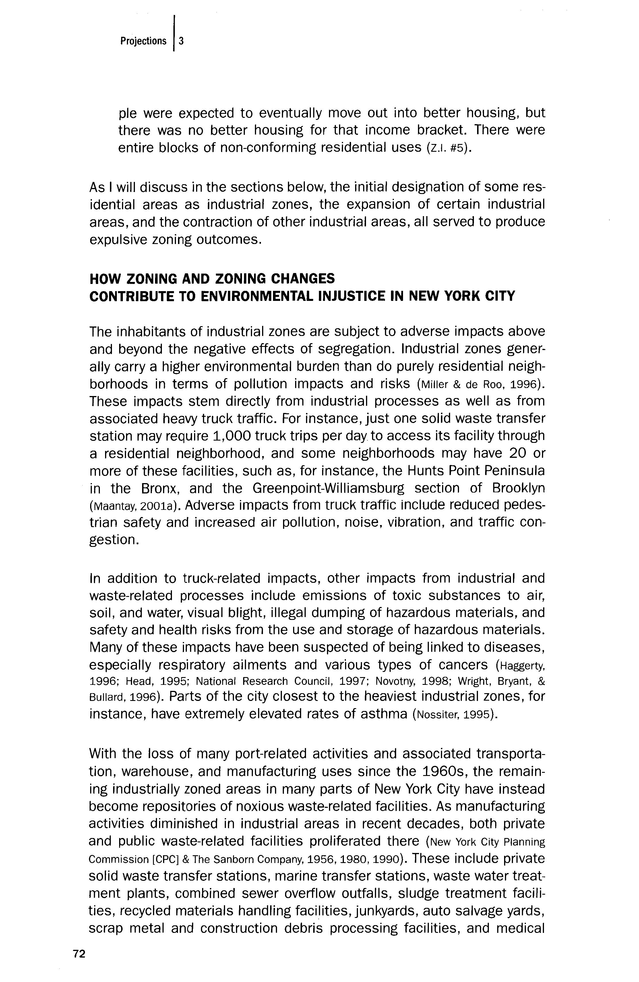
HOW ZONING AND ZONING CHANGES CONTRIBUTE TO ENVIRONMENTAL INJUSTICE IN NEW YORK CITY
The inhabitants of industrial zones are subject to adverse impacts above and beyond the negative effects of segregation. Industrial zones generally carry a higher environmental burden than do purely residential neighborhoods in terms of pollution impacts and risks (Miller & de Roo, 1996). These impacts stem directly from industrial processes as well as from associated heavy truck traffic. For instance, just one solid waste transfer station may require 1,000 truck trips per day to access its facility through a residential neighborhood, and some neighborhoods may have 20 or more of these facilities, such as, for instance, the Hunts Point Peninsula in the Bronx, and the Greenpoint-Williamsburg section of Brooklyn (Maantay, 2001a). Adverse impacts from truck traffic include reduced pedestrian safety and increased air pollution, nOise, vibration, and traffic congestion.
In addition to truck-related impacts, other impacts from industrial and waste-related processes include emissions of toxic substances to air, soil, and water, visual blight, illegal dumping of hazardous materials, and safety and health risks from the use and storage of hazardous materials. Many of these impacts have been suspected of being linked to diseases, especially respiratory ailments and various types of cancers (Haggerty, 1996; Head, 1995; National Research Council, 1997; Novotny, 1998; Wright, Bryant, & Bullard, 1996). Parts of the city closest to the heaviest industrial zones, for instance, have extremely elevated rates of asthma (Nossiter, 1995).
With the loss of many port-related activities and associated transportation, warehouse, and manufacturing uses since the 1960s, the remaining industrially zoned areas in many parts of New York City have instead become repositories of noxious waste-related facilities. As manufacturing activities diminished in industrial areas in recent decades, both private and public waste-related facilities proliferated there (New York City Planning Commission [CPC] & The Sanborn Company, 1956, 1980, 1990). These include private solid waste transfer stations, marine transfer stations, waste water treatment plants, combined sewer overflow outfalls, sludge treatment facilities, recycled materials handling facilities, junkyards, auto salvage yards, scrap metal and construction debris processing facilities, and medical
72 Projections 13
"MINORITY" POPULATION WITHIN MAJOR M ZONES
By
Borough, Per Decade, As Compared with New York City and Borough Averages
Staten Bronx Brooklyn Manhattan Queens Island New York City 1960
Borough 25.4% 21.6% 39.1% 9.6% 5.8% 22.9%
M Zones 38.4% 31.8% 33.1% 11.7% 7.6% 28.2% 1970
Borough 49.2% 38.4% 45.3% 20.2% 8.9% 36.1%
M Zones 68.3% 45.9% 42.5% 21.5% 18.9% 43.6% 1980
Borough 63.7% 49.0% 43.6% 32.2% 13.4% 44.2%
M Zones 75.1% 54.0% 37.9% 32.2% 33.3% 48.4% 1990
Borough 77.1% 59.7% 51.0% 51.7% 19.8% 56.6%
M Zones 87.4% 63.6% 37.9% 51.2% 33.1% 60.7%
waste disposal plants (Bronx Borough President's Solid Waste Management Task Force, 1997). The substitution of waste facilities for viable manufacturing furthers the impression that these communities are being disproportionately "dumped on" (Maantay,2001a).
New York City Industrial Zone Case Study Analytical Methodology and Findings
The scope of the impacts of industrial zones is not trivial: approximately 22 percent of New York City's 1990 census population lives in census tracts that are within these major M zones (Maantay, 2000; Maantay, 2001b). People living in or adjacent to the major M zones are more likely to be poorer than the average New Yorker, and more likely to be a member of a "minority" group (see Figure 2 and Tables 1 and 2). 4 This statement holds true for census data from 1960, 1970, 1980, and 1990 (Maantay, 2000). Although this study was conducted before the 2000 census data were available, subsequent analysis of Bronx 2000 census data reveals that the M zones still contain a higher percentage of minorities than borough- or city-wide averages, despite the fact that the population of the Bronx is greater than 85% minority overall (Maantay,2002b).
Additionally, although the general locations of industrial districts have remained roughly the same over the past century, the geographic extents and boundaries of M zones have not remained static over time, with some M zones being increased and others decreased in area. Individual M zones are reduced or enlarged in extent via the legal mechanism of the zoning change. In order to examine the pattern of industrial zones and zoning changes and to characterize the proximate populations, major M zones and all re-zoning actions occurring between the years 1961-1998 were mapped using GIS. The 1961-1998 time frame was selected for the study because December 1961 marks the date of the last major overhaul
Table
I
1.
Maa'ta,
73
MEAN HOUSEHOLD INCOME WITHIN MAJOR M ZONES
By Borough, Per Decade, As Compared with New York City and Borough Averages ($)
Staten
Bronx Brooklyn Manhattan Queens Island New York City 1970
Borough $ 9,635 $ 10,181 $ 14,242 $ 13,003 $12,934 $ 11,638 M Zones $ 7,889 $ 9,113 $ 10,597 $11,549 $10,921 $ 9,696 1980
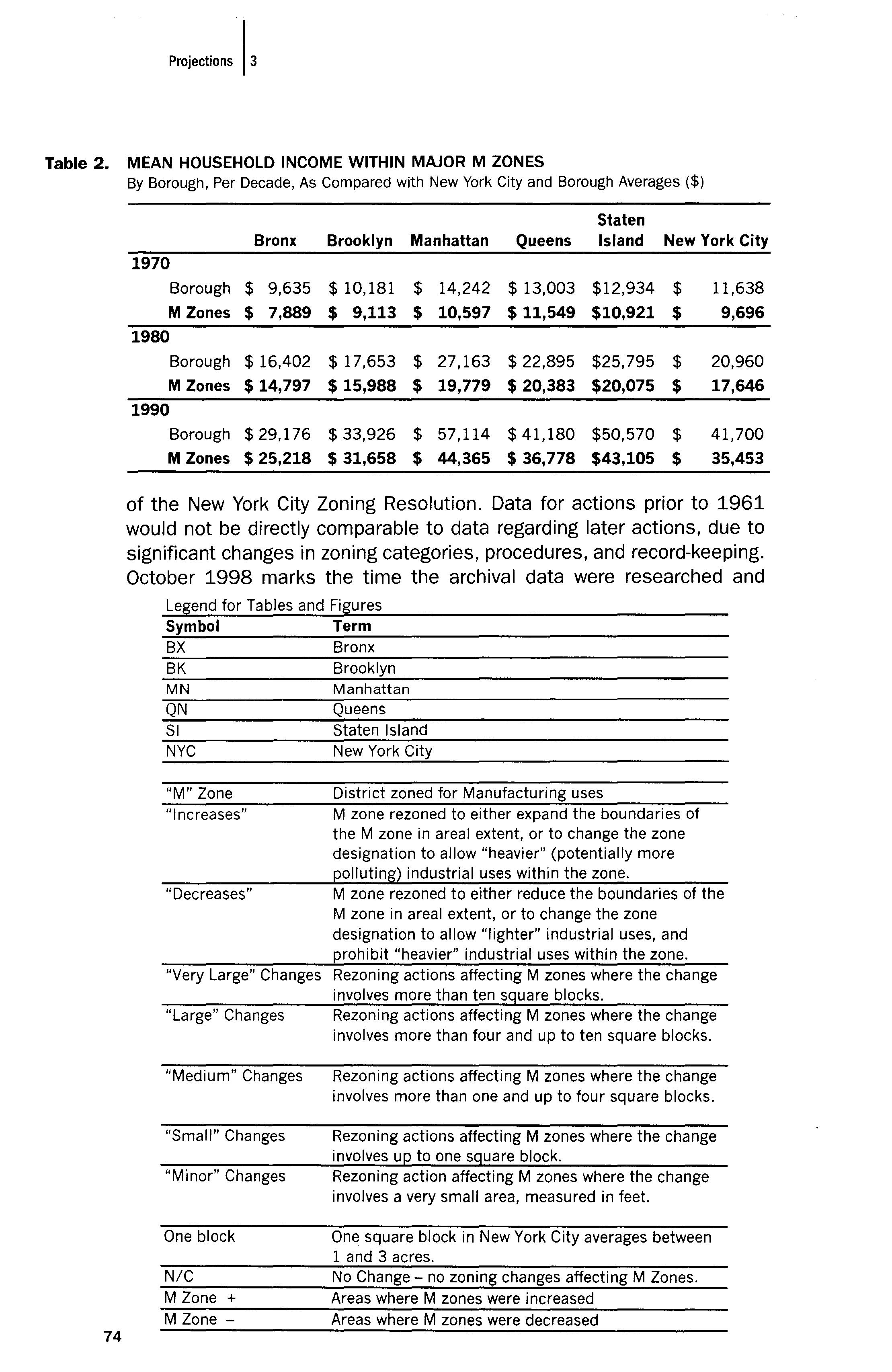
One block N/C M Zone + M Zone
Manhattan Queens Staten Island New York City
District zoned for Manufacturing uses M zone rezoned to either expand the boundaries of the M zone in areal extent, or to change the zone designation to allow "heavier" (potentially more polluting) industrial uses within the zone. M zone rezoned to either reduce the boundaries of the M zone in areal extent, or to change the zone designation to allow "lighter" industrial uses, and prohibit "heavier" industrial uses within the zone.
Rezoning actions affecting M zones where the change involves more than ten square blocks.
Rezoning actions affecting M zones where the change involves more than four and up to ten square blocks.
Rezoning actions affecting M zones where the change involves more than one and up to four square blocks.
Rezoning actions affecting M zones where the change involves up to one square block.
Borough $ 16,402 $ 17,653 $ 27,163 $ 22,895 $25,795 $ 20,960 M Zones $14,797 $ 15,988 $ 19,779 $ 20,383 $20,075 $ 17,646 1990 Borough $ 29,176 $ 33,926 $ 57,114 $ 41,180 $50,570 $ 41,700 M Zones $ 25,218 $ 31,658 $ 44,365 $ 36,778 $43,105 $ 35,453 of the New York City Zoning Resolution. Data for actions prior to 1961 would not be directly comparable to data regarding later actions, due to significant changes in zoning categories, procedures, and record-keeping. October 1998 marks the time the archival data were researched and Legend for Tables and Figures Symbol Term BX Bronx BK Brooklyn MN QN SI NYC "M" Zone "Increases" "Decreases" "Very Large" Changes "Large" Changes "Medium" Changes "Small" Changes "Minor" Changes
Rezoning action affecting M zones where the change involves a very small area, measured in feet.
One square block in New York City averages between 1 and 3 acres.
No Change no zoning changes affecting M Zones. Areas where M zones were increased Areas where M zones were decreased
Table
74
2.
compiled for this study, and thus represents the end point of the time frame.
The "Major M Zones" as used in this study were those defined by the New York City Department of City Planning (DCP) in their "Citywide Industry Study: Geographical Atlas of Industrial Areas," January, 1993. DCP's determination of what constitutes "major" industrial zones was based on an assessment of several factors: the amount of land zoned for industry, the number of people employed in industry for that area, and transportation access. The boundaries for these major industrial districts were based on neighborhood boundaries, major geographic or physical features, historic and present day functions, and census tract boundaries, where feasible.
The determination of where M zone changes had occurred was based on comparison of archival zoning change maps, Map Sections 1-35, New York City DCp, 1961-1998. By comparing thousands of archival zoning change maps, by extracting the changes affecting M zones, and by spatially plotting the changes in industrial zones over time, the pattern of zoning changes affecting industrial zones between 1961-1998 can be shown.
The locations of major M zones and M zone changes were overlain with a spatial database of census tracts, linked to attribute data of population characteristics. Digital data sources were used so that census data could be mapped and analyzed through Geographical Information Systems (GIS) on the computer (Adams, 1980; United States Department of Commerce, Bureau of the Census, 1990; United States Department of Commerce, Bureau of the Census, 1980).
New York City was divided into 2,218 census tracts for the 1990 census. Population characteristics such as race, ethnicity, and income were obtained from census attribute data from 1960, 1970, 1980, and 1990, and these were mapped and compared using a standard deviation classification method in order to allow longitudinal comparison of deviation from the average, since absolute numbers for income and percent minority changed drastically over the four decade period. Population information was aggregated from census tract data for each of the four census periods, at the following geographic levels: city-wide, borough-wide, census tracts within major M zones, census tracts within 1/2 mile of "large" and "very large" M zone increases (see zoning change definitions above), and census tracts within 1/2 mile of "large" and "very large" M zone decreases.
The re-zonings were classified by type and magnitude, and were aggregated both by decade and by borough. Size categories used were: minor boundary adjustments (very small zoning change measured in feet); small (one block or less); medium (more than one block, up to four
1M"""
75
"LARGE" + "VERY LARGE" M ZONE CHANGES, 1961- 1998
By Borough, Per Decade
Staten New York Bronx Brooklyn Manhattan Queens Island City 1960
Increases 2 4 0 2 9 Decreases 1 2 1 2 1 7
Total Changes 3 6 1 4 2 16 1970
Increases 2 0 0 2 2 6 Decreases 1 8 7 4 7 27
Total Changes 3 8 7 6 9 33 1980
Increases 4 0 1 0 6 Decreases 0 2 4 2 3 11
Total Changes 4 2 5 3 3 17 1990
Increases 0 0 0 0 Decreases 2 3 4 5 15
Total Changes 2 3 4 6 1 16 1961·1998
Increases 8 4 1 6 3 22 Decreases 4 15 16 13 12 60 Total Changes 12 19 17 19 15 82
blocks); large (more than four blocks, up to ten blocks); and very large (more than ten blocks). New York City's square block size is not consistent, and typically varies between 1 and 3 acres. Parts of the analysiS focused on "large" and "very large" changes since, based on a review of City Planning Commission (CPC) reports and Public Hearing records available for the study time period, it was seen that many of the minor, small, and medium zoning changes appeared to be tied to the needs of specific property owners, and would seem to be an application of "spot zoning," having little to do with comprehensive planning objectives. Also, the large and very large zoning changes can be thought of as having a larger impact on the surrounding communities as well as on the city as a whole, although the incremental effect of many small changes cannot be discounted.
The re-zoning action categories created reflected combinations of the size classification and either of two types of changes: "increases" or "decreases." "Increases" are M zones that were re-zoned either to expand the boundaries of the M zone in areal extent, or to change the zone designation to allow "heavier" (potentially more polluting) industrial uses within the zone. These latter types have been termed "switches to a heavier M zone." "Decreases" are M zones that were re-zoned either to reduce the boundaries of the M zone in areal extent, or to change the zone deSignation to allow "lighter" industrial uses, and prohibit "heavier" industrial uses within the zone. These latter types have been termed
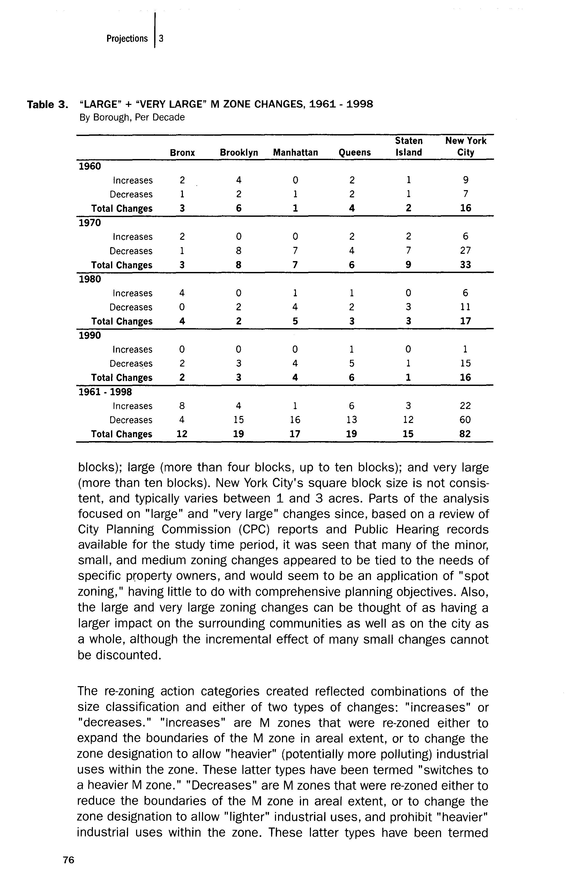
Table 3. 76 Project;ons I,
BRONX "MINORITY" POPULATION IN REZONED M ZONES, BEFORE + AFTER REZONING
Compared with Borough + Major M Zone
Averages
% Minority Population 1960 Census 1970 Census 1980 Census 1990 Census
Bronx Borough 25.4% 49.2% 63.7% 77.1%
Bronx M Zones 38.7% 68.3% 75.1% 87.4%
Increases + Decreases in M Zones
1960 Increase 67.6% 90.1% 97.2% 98.5%
1960 Decrease 22.3% 31.4% 43.1% 63.9%
1970 Increase 6.9% 26.4% 87.2% 77.4%
1970 Decrease 15.1% 31.2% 44.1% 65.9%
1980 Increase 42.7% 84.4% 93.0% 97.5%
1980 Decrease NIC NIC NIC NIC
1990 Increase N/C N/C N/C N/C
1990 Decrease 54.8% 77.2% 91.6% 97.7%
"switches to a lighter M zone."
New York has reduced the overall amount of land zoned for industry by re-zoning a substantial amount of its Manufacturing zones to other uses. There were approximately 409 re-zoning actions (map changes) affecting M zones between 1961 and the present. The city re-zoned land from M to residential (R) or commercial (C) about 50 percent more often than it re-zoned land from other uses to M. Eighty-two of these changes were large or very large in scope, affecting from more than four blocks up to ten blocks, and more than ten blocks, respectively. Not only was there a disparity between the number of M zone decreases versus increases, but there was also a disparity in where these changes occurred. Some boroughs have had virtually no large or very large increases, and some boroughs have had virtually no large or very large decreases (see Table 3).
Industrial areas re-zoned to increase the size or intensity of M zones tended to have populations at the time of the re-zoning that were more heavily minority and poorer than borough and/or city averages, and often more so than the borough M zone average. Areas re-zoned to decrease the size or intensity of M zones tended to have populations at the time of the re-zoning that were not as poor or as heavily minority as the M zone average and/or borough and city averages (see Figure 3).
The analysis also indicates that the areas that are re-zoned to increase M zones are not only more likely to have a higher than average percentage of minority people with lower than average incomes, but that after rezoning to increase M districts these areas increasingly diverge from the borough and city averages they become poorer and more heavily minor-
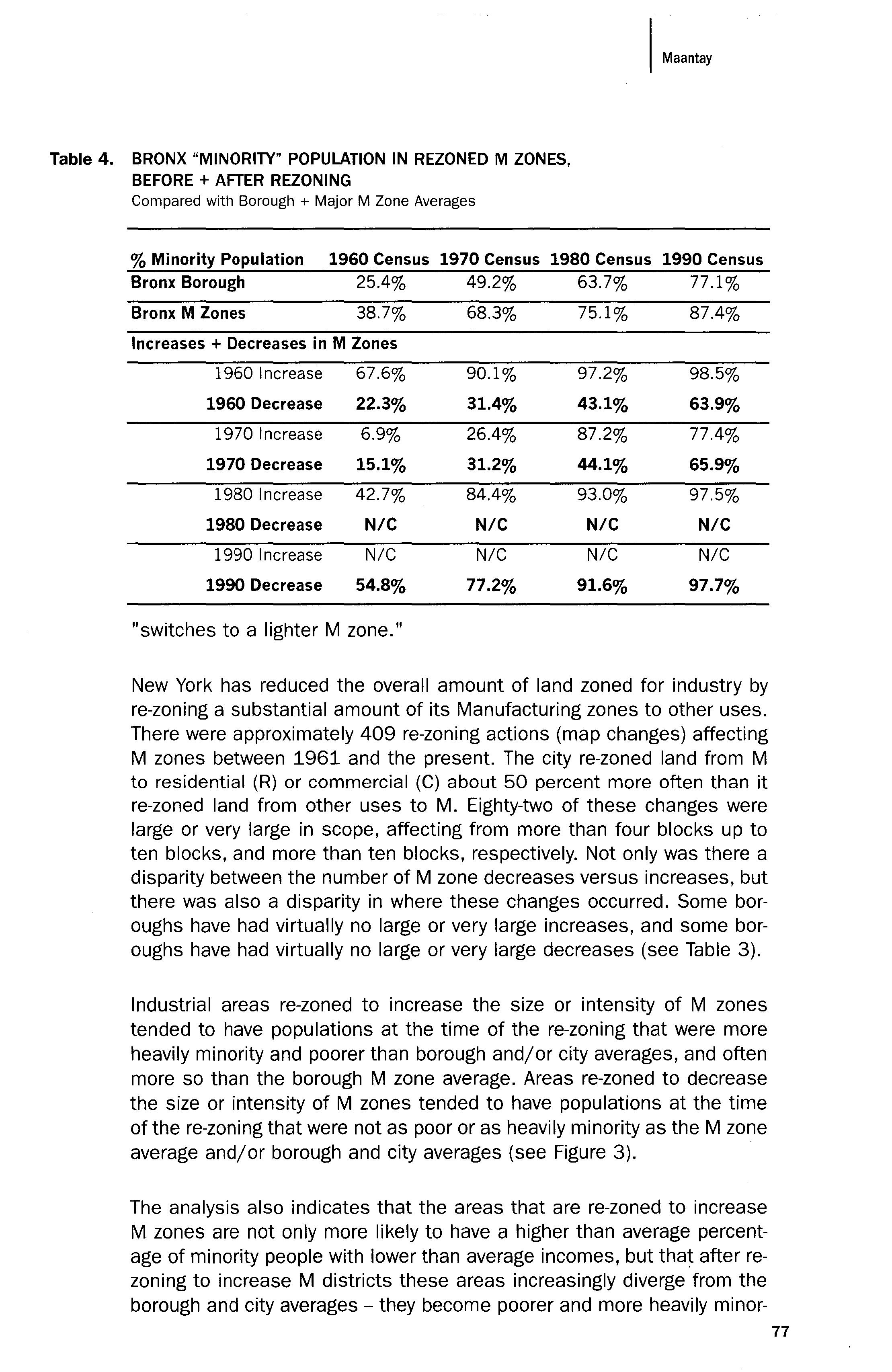
Table 4.
77
BRONX AVERAGE HOUSEHOLD INCOME IN REZONED M ZONES, BEFORE + AFTER REZONING
Compared with Borough + Major M Zone Averages
Mean Income
1970 Census 1980 Census 1990 Census
Bronx Borough 9,635 16,402 29,176
Bronx M Zones 7,889 14,797 25,218
Increases + Decreases in M Zones
1960 Increase 6,190 9,850 16,808
1960 Decrease 12,247 22,872 35,550 1970 Increase 11,378 19,107 32,844
1970 Decrease 12,148 22,805 36,709
1980 Increase 6,869 11,186 20,869 1980 Decrease NIC NIC NIC 1990 Increase N/C N/C N/C 1990 Decrease 8,033 11,800 19,309
ity relative to the rest of the borough and city. Conversely, areas re-zoned to decrease M districts tend to become more similar to (or even surpass) the borough or city averages with regard to mean income, and more similar to (or lower than) borough and city averages with regard to percent minority population, after re-zoning (see Tables 4 and 5).
Official documents outline the planning rationales behind the re-zoning actions. For instance, "marginal" or "deteriorated" residential neighborhoods are considered more appropriate for re-zoning to industrial than "stable" communities that have been "maintained." Sometimes "market forces" or "market pressures" are cited as reasons for re-zoning districts from M to other uses. The rationales for zoning changes were obtained from archival documentation such as Zoning Amendment Applications, City Planning Commission Calendars, Uniform Land Use Review Procedure (ULURP) applications, Urban Renewal Plans, Environmental Impact Assessments, Planning Studies, and letters and other documents obtained through the New York State Freedom of Information Law (FOIL) for the years 1961-1999. Documents from 1916-1961 were also consulted, as available, for context and background of later policy developments. A complete list of archival documents used is given in Maantay (2000), Appendix C.
Several previous studies have focused on whether the noxious land use or the minority population came first (Been, 1994; Been & Gupta, 1996). In other words, was the noxious facility sited before the nearby population
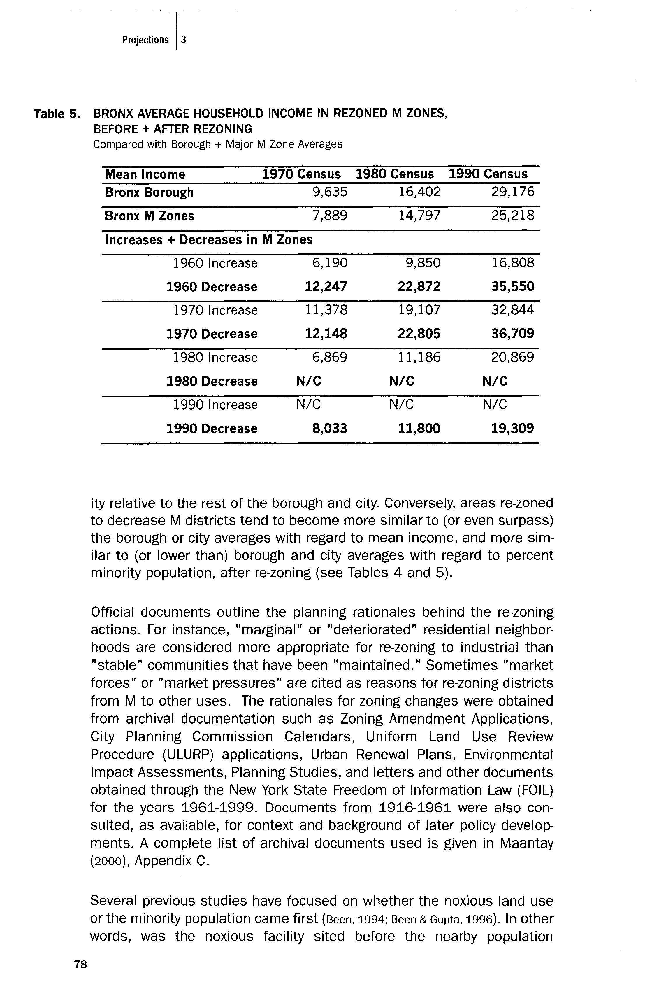
Table 5. 78 P"j''"'"' I,
became predominantly minority and/or poor, or was the neighborhood predominantly minority and/or poor when the facility was sited? I was able to consider this issue, not in terms of particular noxious uses, but in terms of the zoning changes that facilitate the siting of noxious uses. Thus, my research poses a different question: Which came first, the zoning changes or the people? I found that, in many instances, neighborhoods were zoned to increase industrial uses after they had already become poorer and more minority than the city and borough average, and they diverged further from city and borough averages after re-zoning. The issue of "which came first" may be important in establishing intent or racial animus in a legal context, but whether active discrimination or a series of thoughtless decisions and assumptions were behind the zoning changes, the end result remains the same: poor and minority people are disproportionately burdened by industrial zoning changes.
Five Industrially-Zoned Communities
In addition to the city- and borough-wide analyses of demographic and zoning changes, I also looked in detail at five smaller case study industrial areas. The intent of the case studies was to furnish more information about the complexity of the issues involved in the zoning change process than can be obtained by simply looking at the city- or borough-wide patterns and trends of industrial zoning changes. The case study areas were selected to represent a range of industrial areas, and each needed to contain substantial industrial zones as well as contain a residential population. In order to be illustrative of the different types of industrial zoning changes that had taken place. it was desirable to have at least one of each of the following areas represented in the analysis: an area where M zones had been increased; an area where M zones had been decreased; an area where M zones had remained basically the same; and an area where the M zones had been changed to a different kind of M zone. The zoning changes could then be correlated with policy trends, changing demographics, and land use conditions over the four decade study period.
The five case study areas selected were Red Hook, Brooklyn (M zones virtually unchanged); Gowanus Canal, Brooklyn (M zones decreased); Hunts Point, Bronx (M zones "switched" to a heavier M zone); Bathgate, Bronx (large increases in M zones); and the Lower West Side of Manhattan (large decreases in M zones). The last two case study areas will be the focus of this section, and they offer the starkest contrast: the Bathgate area received several large M zone increases, and the Lower West Side received several large and very large M zone decreases.
The data used in the case study area analysis included the census tract population data and the zoning change data used in the city- and borough-wide analysis, as discussed above. In addition, the case study area analysis used land use data obtained from archival land use maps, plan-
79
ning reports, zoning amendment applications, and other zoning change documentation specific to each area. Where applicable, information gleaned from interviews with zoning experts was also incorporated into the case study area analysis. The zoning experts were all people who had been active in New York City zoning issues at some time during the last 40 years, and they included past City Planning Commissioners, former and current DCP staff, planners from community, advocacy, and non-profit planning organizations, and urban planning academics. Because many still work in the New York City planning realm, their comments are presented without attribution. 5
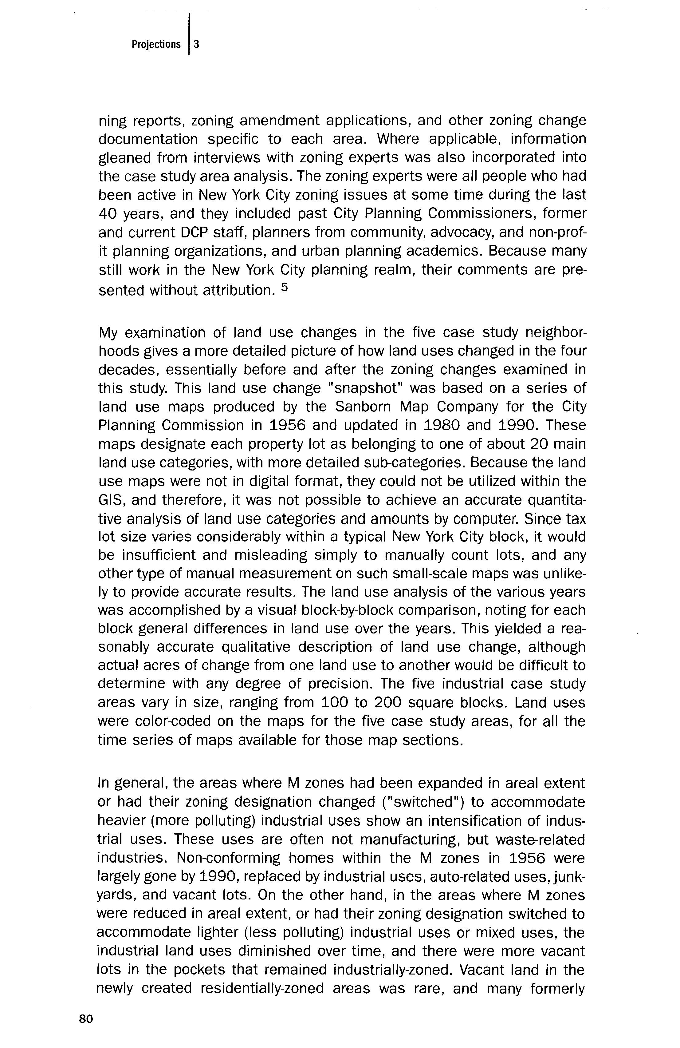
My examination of land use changes in the five case study neighborhoods gives a more detailed picture of how land uses changed in the four decades, essentially before and after the zoning changes examined in this study. This land use change "snapshot" was based on a series of land use maps produced by the Sanborn Map Company for the City Planning Commission in 1956 and updated in 1980 and 1990. These maps designate each property lot as belonging to one of about 20 main land use categories, with more detailed sub-categories. Because the land use maps were not in digital format, they could not be utilized within the GIS, and therefore, it was not possible to achieve an accurate quantitative analysis of land use categories and amounts by computer. Since tax lot size varies considerably within a typical New York City block, it would be insufficient and misleading simply to manually count lots, and any other type of manual measurement on such small-scale maps was unlikely to provide accurate results. The land use analysis of the various years was accomplished by a visual block-by-block comparison, noting for each block general differences in land use over the years. This yielded a reasonably accurate qualitative description of land use change, although actual acres of change from one land use to another would be difficult to determine with any degree of precision. The five industrial case study areas vary in size, ranging from 100 to 200 square blocks. Land uses were color-coded on the maps for the five case study areas, for all the time series of maps available for those map sections.
In general, the areas where M zones had been expanded in areal extent or had their zoning designation changed ("switched") to accommodate heavier (more polluting) industrial uses show an intensification of industrial uses. These uses are often not manufacturing, but waste-related industries. Non-conforming homes within the M zones in 1956 were largely gone by 1990, replaced by industrial uses, auto-related uses, junkyards, and vacant lots. On the other hand, in the areas where M zones were reduced in areal extent, or had their zoning designation switched to accommodate lighter (less polluting) industrial uses or mixed uses, the industrial land uses diminished over time, and there were more vacant lots in the pockets that remained industrially-zoned. Vacant land in the newly created residentially-zoned areas was rare, and many formerly
80
Figure 1. NEW YORK CITY'S " MINORITY" POPULATION BY CENSUS TRACT, 1960 1990
Dat a Source: US Census Bureau , 1960, 1970 , 1980, 1 990
1960 % MINORITY
1 0 Std. Dev D NYC Mean 22 9 %
o 1 Std Dev. _ 1 2 St d Dev. 2 3 Std Dev _ No Data
1970 % MINORITY
1 0 Std Dev. c=J NYC Mean 36 1% o 1 St d Dev. 1 2 Std Dev.
No Data
1980 % MINORITY
1990 % MINORITY .. CJ .. ..
2 1 Std. Dev 1 0 Std Dev 1 0 Std Dev. NYC Mean 44.2% D
2 1 Std. Dev
NYC Mean 56 6 % o - 1 Std. Dev 0 1 Std Dev 1 -2 Std. Dev 1 2 Std Dev No Data
industrial use lots now within R zones had been converted to residential use.
Bathgate, Bronx
Bathgate was chosen for the purposes of this study to represent a com munity that had experienced a major increase in its M zones. About 45 acres of residentially-zoned blocks were re zoned as M zones, including the de-mapping of an "abandoned" playground, according to the MidBronx Industrial Urban Renewal Plan (New York City Department of City Planning , 1982). During the study time period, Bathgate was transformed from a neighborhood of mainly white, lower middle-class and working-class residents to an overwhelmingly minority and poor neighborhood. The 1969
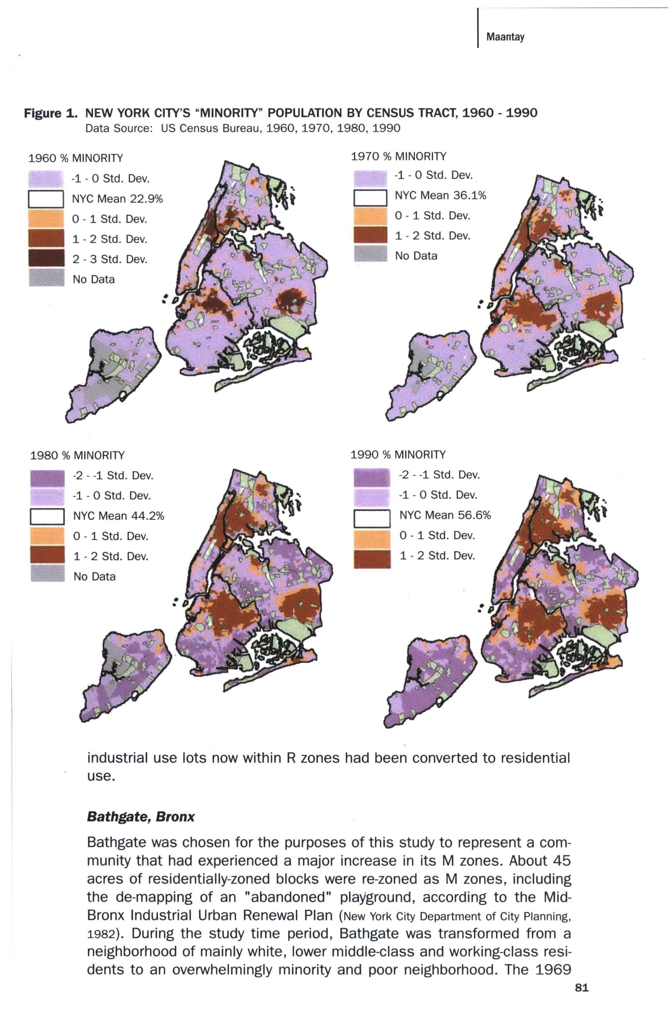
I M".,.y
81
Figure 2. MAJOR MANUFACTURING ZONES + PERCENT "MINORITY" IN NEW YORK
CITY, 1990
Data Sources: US Census Bureau, 1990; New York City Department of City Planning, Citywide Industry Study: Geographical Atlas of Industrial Areas, January, 1993
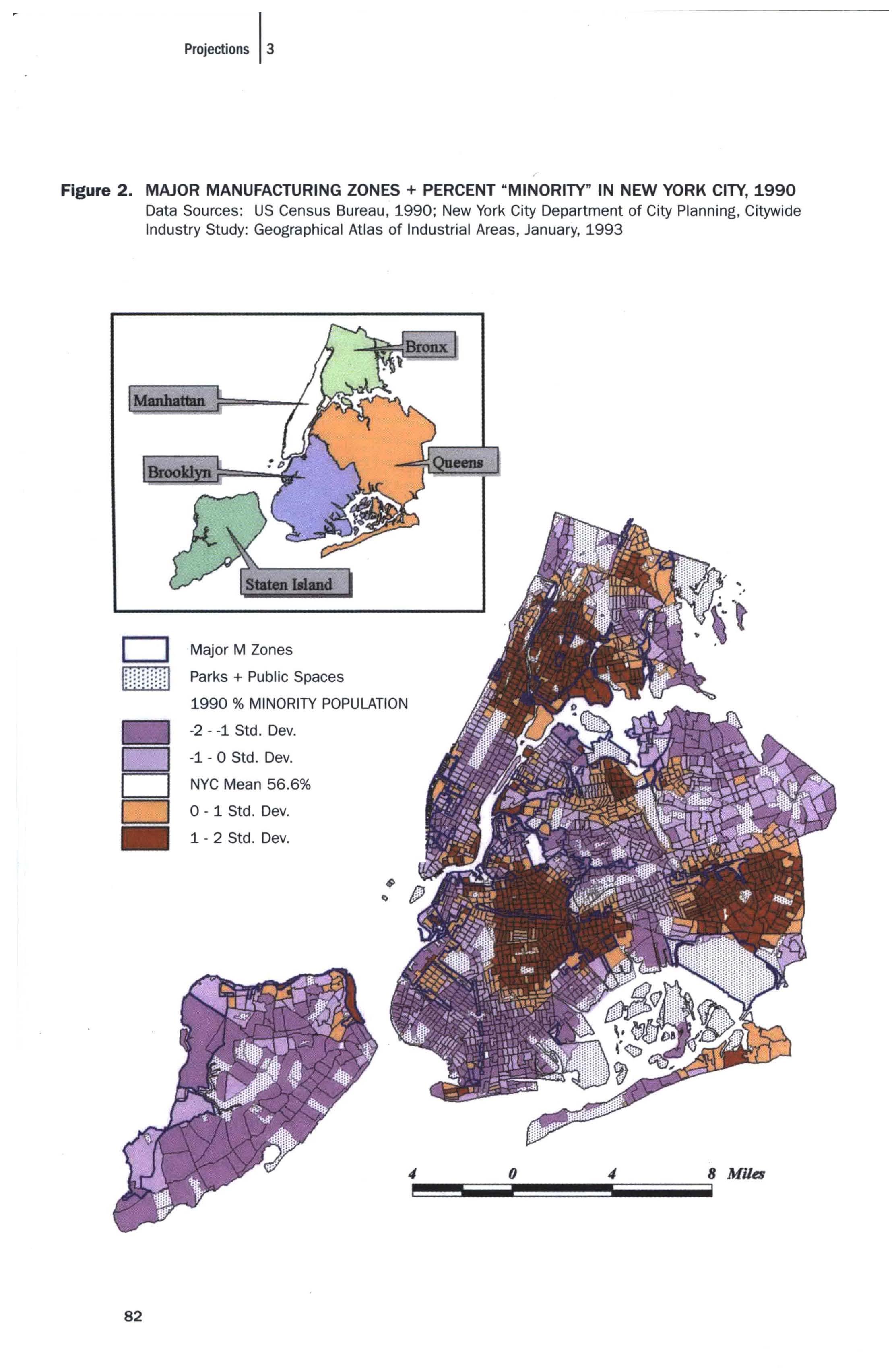
DMajor M Zones Parks + Public Spaces 1990 % MINORITY POPULATION -2 -1 Std. Dev.
-1 0 Std Dev.
NYC Mean 56.6%
Projections 13
o
o
o
82
0-1Std. Dev. _ 1 -2 Std. Dev.
I Maantay Figure 3. MAJOR MANUFACTURING ZONE CHANGES IN THE BRONX, 1961 1998 WITH 1990 MEAN HOUSEHOLD INCOME, WITHIN 1/2 MILE OF ZONING CHANGES Data Sources : US Census Bureau , 1990; New York City Department of City Planning , Map Sections 1 35 , Archival Record of Zoning Map Amendments , 1961 1998 1990 MEAN HOUSEHOLD INCOME 3 2 Std. Dev 2 1 Std. Dev. 1 0 Std. Dev. c=J Bronx Mean $29,200 CJ 0 1 Std. Dev 1 2 Std Dev. 2-3Std. Dev. > 3 Std Dev. No Data o 1/2 Mile from Major M Zone Decrease o 1/2 Mile from Major M Zone Increase o • 1 2 MIlES MAJOR M ZONE INCREASES, 1961- 1998 + Large Increase :x Large Switch to " Heavier" M Zone % Very Large Switch to " Heavier" M Zone MAJOR M ZONE DECREASES , 1961 1998II L..:.:.:J Large Decrease Very Large Decrease Large Switch to " Lighter" M Zone Bron x Parks and Public Spaces 83
Figure 4. BATHGATE, BRONX CASE STUDY AREA POPULATION DENSITY, 1960 + 1990
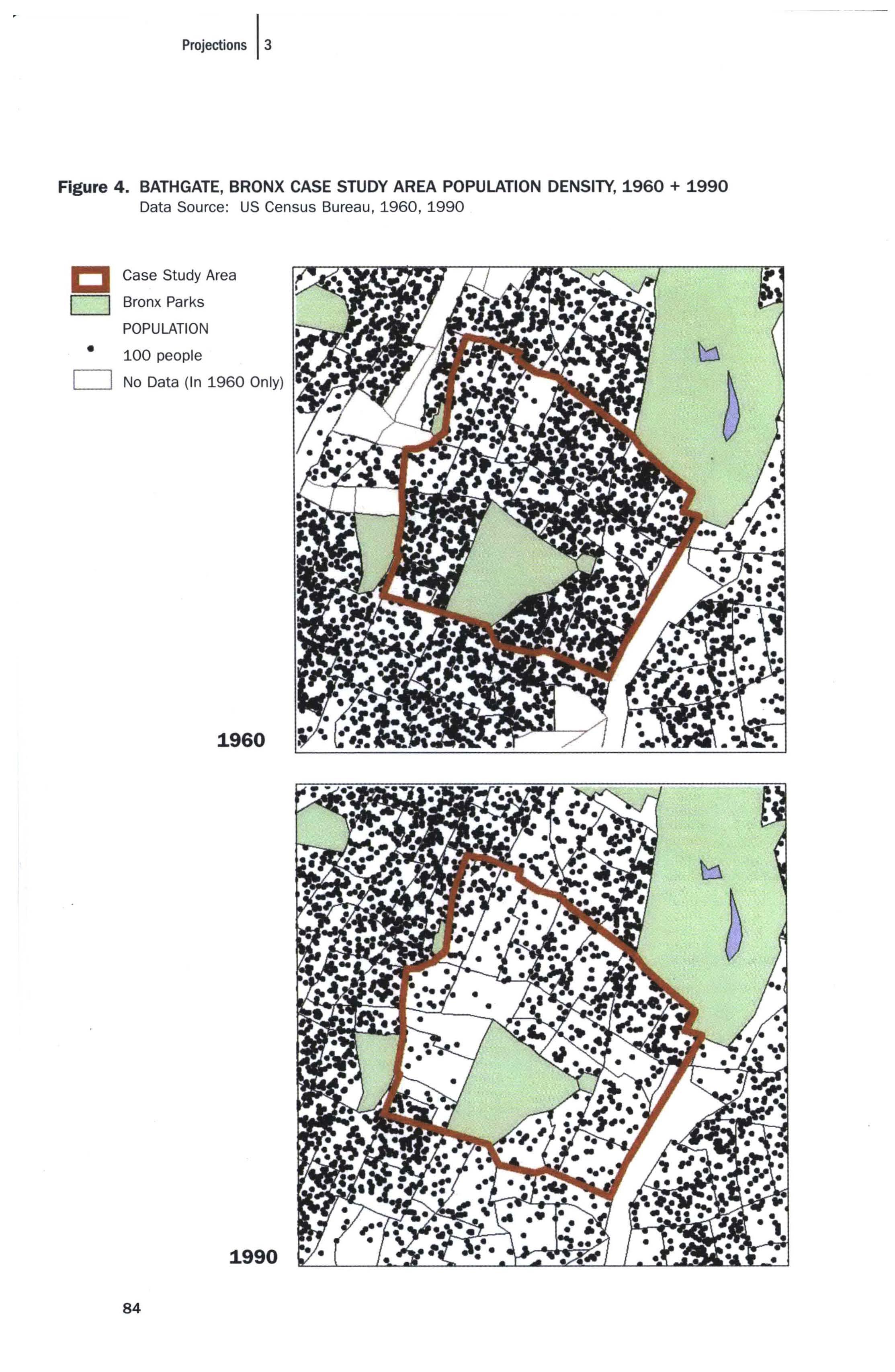
Data Source: US Census Bureau, 1960, 1990
CCase Study Area
c=J Bronx Parks
POPULATION
• 100 people No Data (In 1960 Only)
1960
Projections 13
1990 84
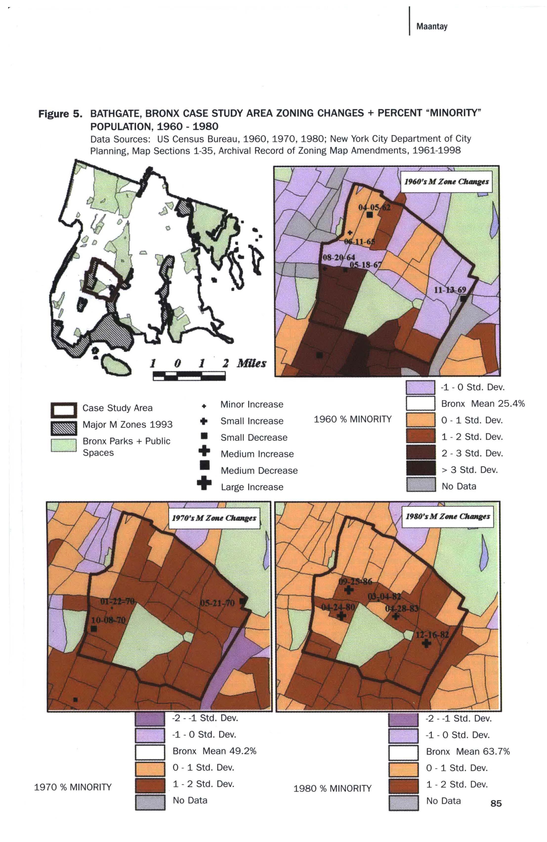
I Maantay Figure 5. BATHGATE, BRONX CASE STUDY AREA ZONING CHANGES + PERCENT "MINORITY" POPULATION, 1.960 1.980 Data Sources: US Census Bureau, 1960, 1970, 1980; New York City Department of City Planning , Map Sections 1-35, Archival Record of Zoning Map Amendments, 1961 1998 I::l Case Study Area _ Major M Zones 1993 c=J Bronx Parks + Public Spaces + • • + Minor Increase Small Increase Small Decrease Medium Increase o -1 0 Std Dev o Bronx Mean 25.4% 1960 % MINORITY 0 0 1 Std. Dev _ 1 2Std. Dev 2 3 Std. Dev. • Medium Decrease > 3 Std Dev. 1970 % MINORITY + Large Increase 1 0 Std. Dev Bronx Mean 49 2% 1 2 Std Dev. No Data o No Data 1 0 Std . Dev. Bronx Mean 63.7 % 0 1 Std. Dev. 1980 % MINORITY _ 1 2 Std. Dev. D No Data 85
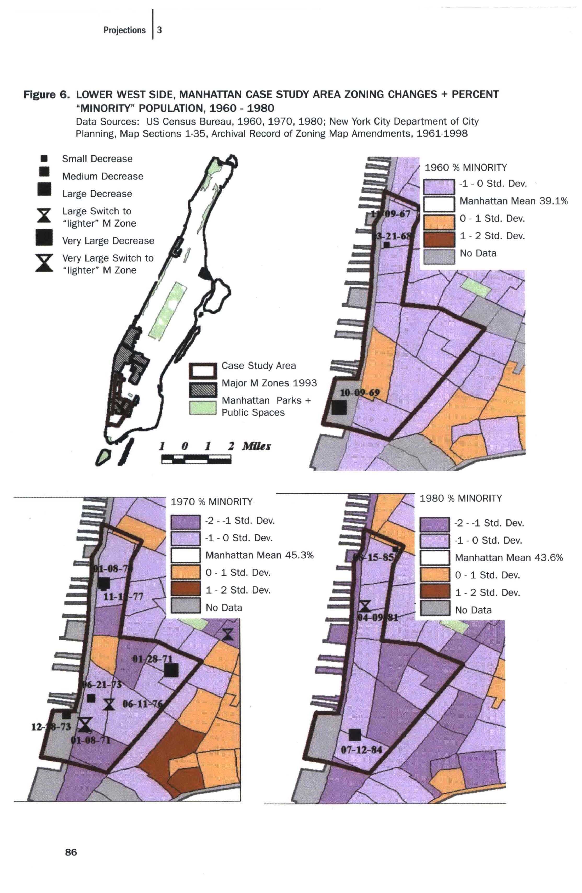
Projections 13 Figure 6. LOWER WEST SIDE, MANHATTAN CASE STUDY AREA ZONING CHANGES + PERCENT "MINORITY" POPULATION, 1960 1980 • • • :x • x: Data Sources : US Census Bureau, 1960, 1970, 1980; New York City Department of City Planning, Map Sections 1-35, Archival Record of Zoning Map Amendments , 1961 1998 Small Decrease Medium Decrease Large Decrease Large Switch to "lighter" M Zone Very Large Decrease Very Large Switch to " lighter" M Zone 86 r---1 Manhattan Parks + L--J Public Spaces 1 0 1 1 Mlhs P""'I 1- 0 Std. Dev. Manhattan Mean 45.3% -1- 0 Std. Dev Manhattan Mean 39 1 % 1 2 Std. Dev 1980 % MINORITY 1 0 Std. Dev. Manhattan Mean 43.6% 1 2 Std. Dev.
New York City Master Plan describes the area as "economically and socially depressed and physically blighted" (New York City Planning Commission, 1969, p. 36). This did not happen overnight, nor was there anyone cause, but the changes were propelled, in large measure, by the construction of the Cross-Bronx Expressway, which tore the neighborhood in two and destroyed the physical fabric of Bathgate, as well as its community cohesiveness (Caro, 1979; New York City Department of City Planning, 1993). As these demographic and socio-economic changes occurred, other broader trends and far-reaching circumstances led to severe private disinvestment in neighborhoods like Bathgate. Wholesale landlord abandonment of its housing stock took place, leading to widespread destruction of property and city take-over of buildings. Although the city inherited much of the property in the community, becoming in effect its biggest landlord, it also declined to invest in the area, and the housing stock deteriorated further.
Many residential buildings [in Bathgate] were vacant and derelict, and we didn't have a housing program [funding opportunities for new housing construction or renovation] at that time [the 1970s-1980s], and the philosophy was to create jobs for people. The only way to create jobs, it was thought, was to create sites with large floor plates so that you could build new manufacturing plants that could accommodate the single story production flow (z.1. #7).
Using the land use maps, one can trace the dramatically increasing numbers of vacant lots, the increase in public housing projects, the reduction in the number of private homes and, often, the change in use of the housing over the study time period. Some of the remaining private houses which previously had been deSignated as #3, #4, or #5 on the land use map, meaning they had been single-family detached, single-family attached, or two-family homes, were now given a deSignation such as "#4-12" on the map, indicating that although it was considered a singlefamily attached structure, it was now being used for (public) social services purposes. The over-saturation of "community facilities," such as drug rehabilitation centers and homeless shelters, also may have contributed to the downward spiral of Bathgate. It obviously had become a convenient dumping ground for the city's most locally undesirable land uses. There had been a building boom in large-scale public housing projects in the Bathgate vicinity starting in the 1960s. Several thousand new dwelling units had been built in the area during the study time period, but despite the large and almost permanent "captive" population in the new public housing, substantial overall depopulation occurred in the area from 1960 to 1990, with a two-thirds reduction of the population from 1970 to 1980 alone. The population of the case study area went from about 144,000 to about 52,000 in that 10-year period (see Figure 4).
Bathgate was one of the poorest and most heavily minority neighbor-
I Maa'..,
87
Table 6.
hoods in the Bronx, and possibly in the entire city, at the time that three of its large residential areas were proposed for re-zoning to industrial districts, as part of an urban renewal plan to establish several industrial parks (see Figure 5).
Bathgate had been burned out it had been one of the first victims of the South Bronx syndrome. It was thought to be an appropriate area to symbolize the phoenix that rises up out of the ashes. [The Bathgate Industrial Park] was meant to be a showcase to address the lack of suitable jobs and the high unemployment at the time among this population. The idea was that the people living in the neighborhood would be the ones benefiting from the jobs. One of the great myths of city planning is the walk-to-work myth Bathgate had so many low-income housing projects that you almost had to do a Bathgate [Industrial Park] to justify the concentration of low-income housing if you were redeveloping the area (z.1. #5).
The neighborhood was viewed by the DCP staff and Commissioners as a "marginal residential neighborhood" and as "attractive for re-zoning to
MINORITY POPULATION IN THE BATHGATE CASE STUDY AREA
Compared with New York City + the Bronx, 1960 1990 (Percent)
Bathgate/Crotona Park Bronx New York 1960 39.10% 25.40% 22.90% 1970 90.80% 49.20% 36.10% 1980. 96.20% 63.70% 44.20% 1990 98.70% 77.10% 56.40%
Table 7.
MEAN HOUSEHOLD INCOME FOR THE BATHGATE CASE STUDY AREA
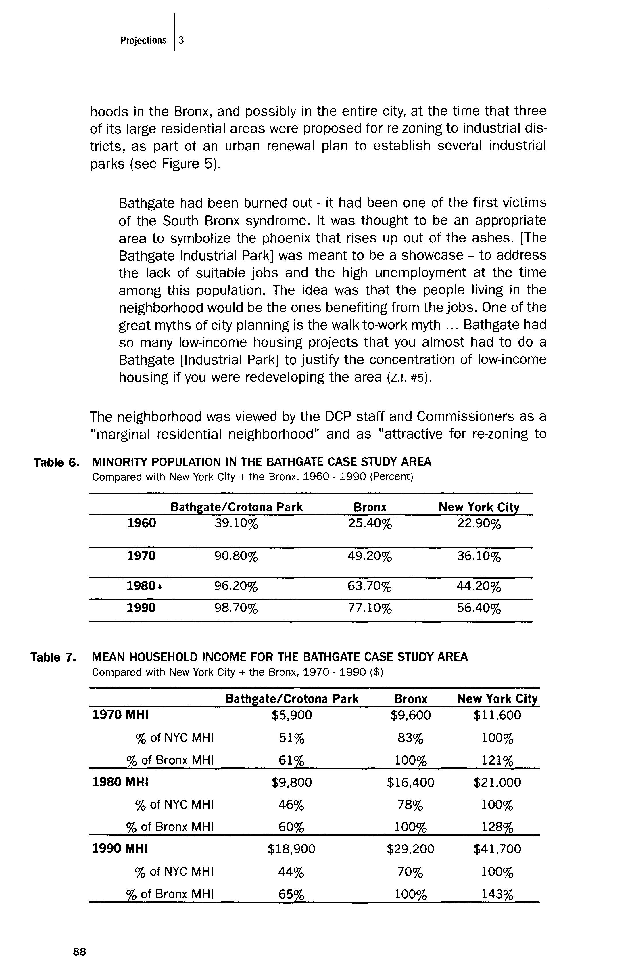
Compared with New York City + the Bronx, 1970 1990 ($)
Bathgate/Crotona Park Bronx New York 1970 MHI $5,900 $9,600 $11,600 % of NYC MHI 51% 83% 100% % of Bronx MHI 61% 100% 121% 1980 MHI $9,800 $16,400 $21,000 % of NYC MHI 46% 78% 100% % of Bronx MHI 60% 100% 128% 1990 MHI $18,900 $29,200 $41,700 % of NYC MHI 44% 70% 100% % of Bronx MHI 65% 100% 143%
88
industrial uses." Following are some excerpts from three different re-zoning documents that outline the planning rationale behind the proposed changes from residential to industrial:
The objectives of the Mid-Bronx Industrial Urban Renewal Plan are ... to remove blight, unsanitary, and hazardous conditions presently within the urban renewal area, to demolish and clear existing substandard and unsanitary structures ... [and to establish] land use patterns consistent with modern planning concepts and conducive to the creation of a superior living and working environment... (A·1358/ 820721ZMX, 1/1981, from the Mid·Bronx Industrial Urban Renewal Plan).
The proposed action is the re-zoning of all or portions of seven blocks of the Bathgate area from residential with commercial overlay to manufacturing. The goals of the proposed actions are to encourage industrial/commercial development in the area, enhance the market potential of unproductive real estate (private and public) and provide employment opportunities for area residents (A-1453 / 860696ZMX, 2/25/86, from ULURP Application form).
Over the past decade, Bathgate North has become a marginal residential neighborhood. The Community experienced the same decline, deterioration, obsolescence and abandonment of residential real property which spread through much of the South Bronx during the 1970s. The area was originally considered a desirable residential neighborhood, adjacent to the Crotona Park extension However, the deteriorating character of many of these buildings, together with the demographic changes of the past two decades, resulted in a declining demand for the housing stock of the area The project area has abandoned residential buildings, an increase in property reverting to city ownership, and a considerable amount of ongoing demolition. Manufacturing uses have replaced residential uses as the predominant land use in the area. Housing conditions suggest that residential use will not recover in the foreseeable future ... The area proposed for re-zoning is attractive for industrial uses ... The commission has therefore concluded that the proposed re-zoning is appropriate (A-2453 / 860696ZMX, 8/6/86, From City Planning Commission Report, Calendar No. 80).
These statements were made at a time when the city was losing large amounts of its manufacturing-zoned areas in Manhattan due to "market pressures" and conversion to residential or mixed-use zones, as discussed below. The Bathgate industrial parks were intended to make a profitable use of the blighted area, in lieu of repairing or replacing housing and promoting community-based development schemes.
The community was opposed to the Bathgate Industrial Park. The
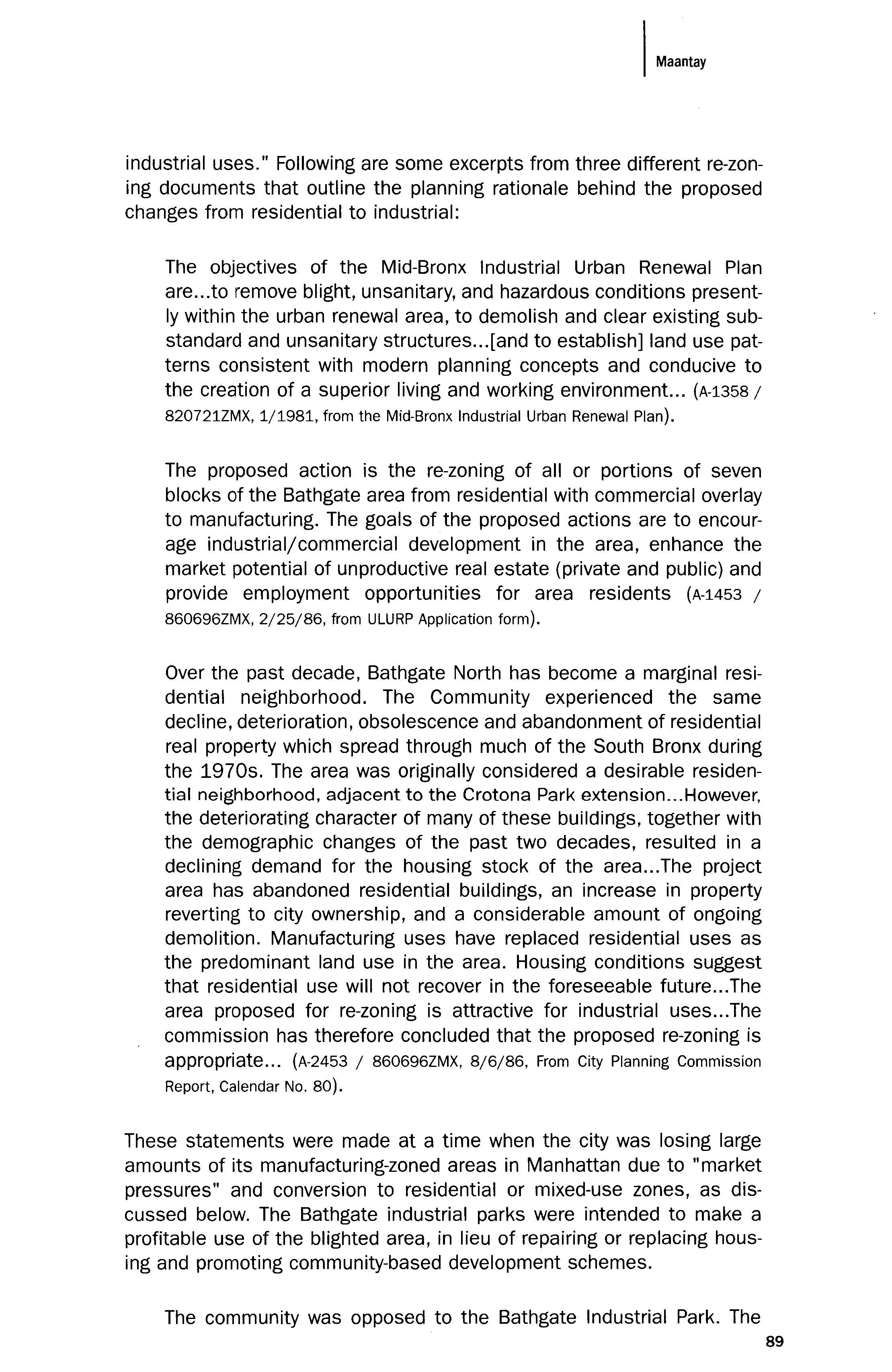
I
Maa"",
89
community would have preferred residential development. The Chairman of the Board in [Community] District 3 was also head of a community association in Bathgate, and he was opposed to the rezoning and the whole industrial park strategy. His argument was that this was an area in between two parks, and that it could have been and should have been redeveloped as a low-rise residential area (z.1. #6).
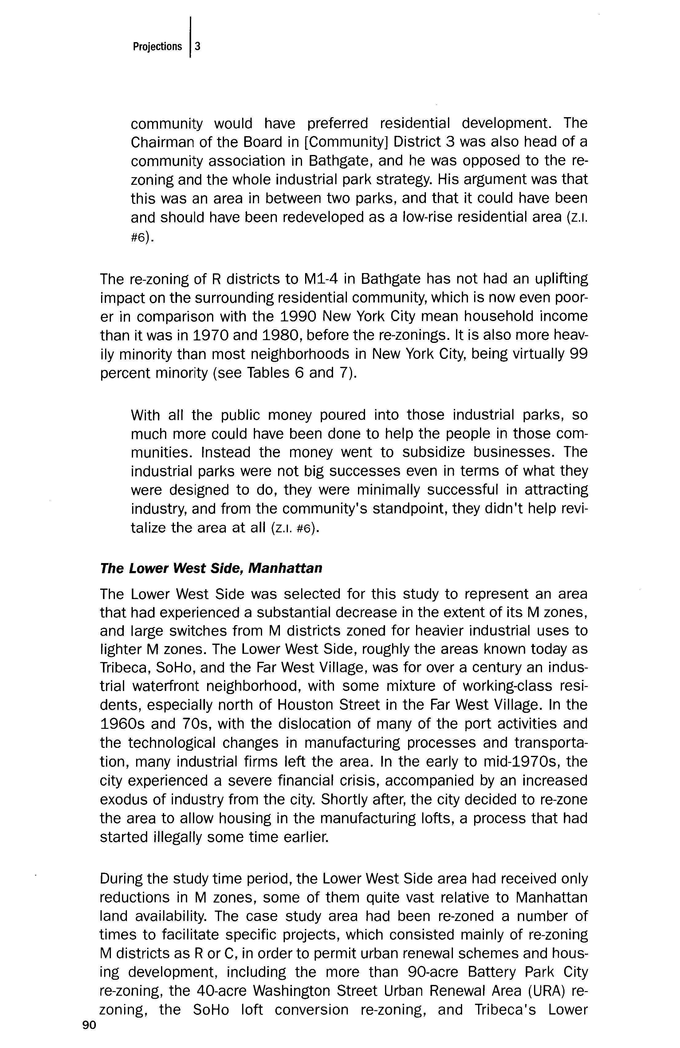
The re-zoning of R districts to M1-4 in Bathgate has not had an uplifting impact on the surrounding residential community, which is now even poorer in comparison with the 1990 New York City mean household income than it was in 1970 and 1980, before the re-zonings. It is also more heavily minority than most neighborhoods in New York City, being virtually 99 percent minority (see Tables 6 and 7).
With all the public money poured into those industrial parks, so much more could have been done to help the people in those communities. Instead the money went to subsidize businesses. The industrial parks were not big successes even in terms of what they were designed to do, they were minimally successful in attracting industry, and from the community's standpoint, they didn't help revitalize the area at all (z.1. #6).
The Lower West Side, Manhattan
The Lower West Side was selected for this study to represent an area that had experienced a substantial decrease in the extent of its M zones, and large switches from M districts zoned for heavier industrial uses to lighter M zones. The Lower West Side, roughly the areas known today as Tribeca, SoHo, and the Far West Village, was for over a century an industrial waterfront neighborhood, with some mixture of working-class residents, especially north of Houston Street in the Far West Village. In the 1960s and 70s, with the dislocation of many of the port activities and the technological changes in manufacturing processes and transportation, many industrial firms left the area. In the early to mid-1970s, the city experienced a severe financial crisis, accompanied by an increased exodus of industry from the city. Shortly after, the city decided to re-lone the area to allow housing in the manufacturing lofts, a process that had started illegally some time earlier.
During the study time period, the Lower West Side area had received only reductions in M zones, some of them quite vast relative to Manhattan land availability. The case study area had been re-zoned a number of times to facilitate specific projects, which consisted mainly of re-zoning M districts as R or C, in order to permit urban renewal schemes and housing development, including the more than 90-acre Battery Park City re-zoning, the 40-acre Washington Street Urban Renewal Area (URA) rezoning, the SoHo loft conversion re-zoning, and Tribeca's Lower
90
Manhattan Mixed-Use District re-zoning.
The New York City 1969 Master Plan described the area now known as the South Houston Industrial Area (SoHo) as follows:
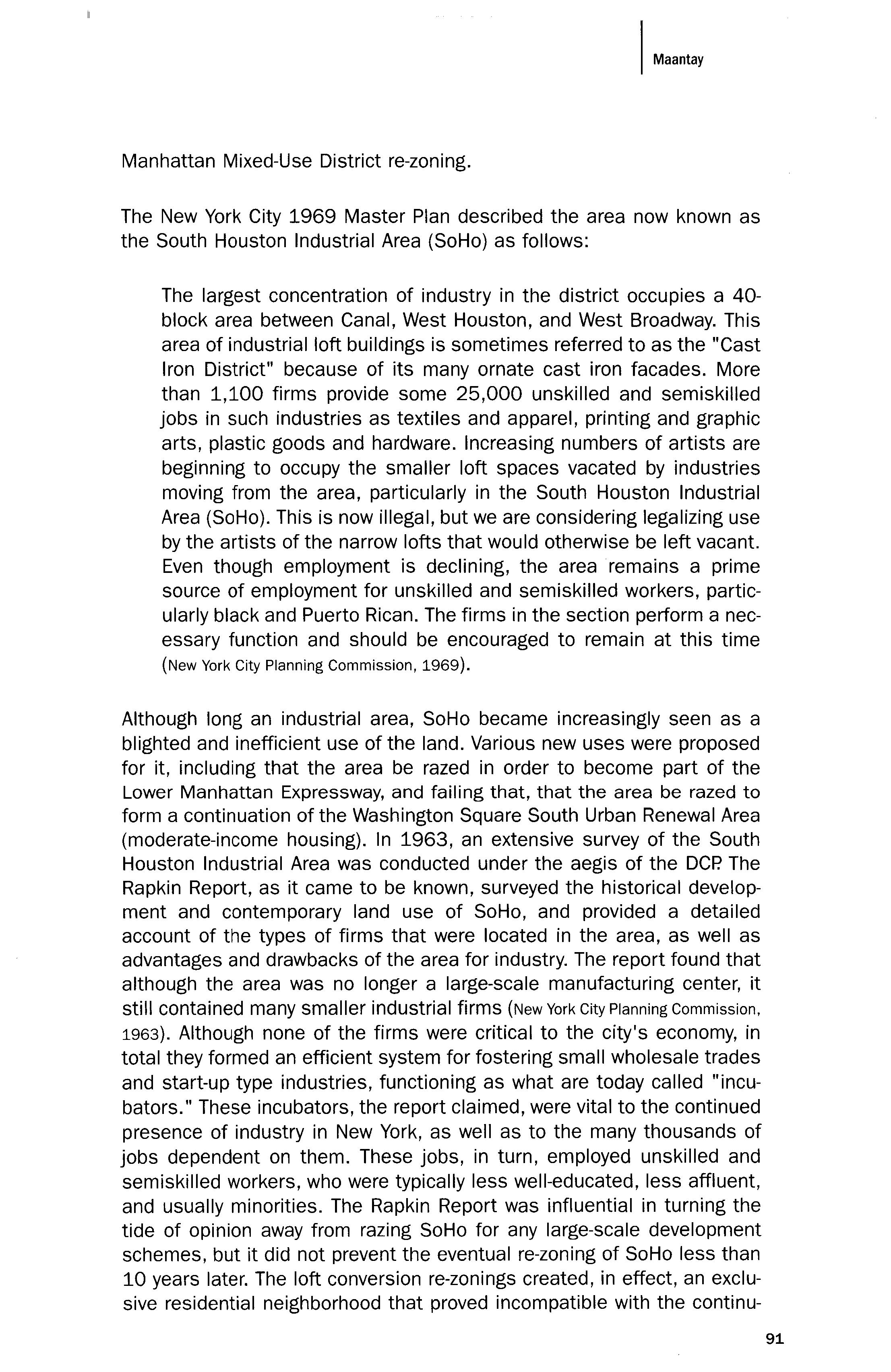
The largest concentration of industry in the district occupies a 40block area between Canal, West Houston, and West Broadway. This area of industrial loft buildings is sometimes referred to as the "Cast Iron District" because of its many ornate cast iron facades. More than 1,100 firms provide some 25,000 unskilled and semiskilled jobs in such industries as textiles and apparel, printing and graphic arts, plastic goods and hardware. Increasing numbers of artists are beginning to occupy the smaller loft spaces vacated by industries moving from the area, particularly in the South Houston Industrial Area (SoHo). This is now illegal, but we are considering legalizing use by the artists of the narrow lofts that would otherwise be left vacant. Even though employment is declining, the area remains a prime source of employment for unskilled and semiskilled workers, particularly black and Puerto Rican. The firms in the section perform a necessary function and should be encouraged to remain at this time (New York City Planning Commission, 1969).
Although long an industrial area, SoHo became increasingly seen as a blighted and inefficient use of the land. Various new uses were proposed for it, including that the area be razed in order to become part of the Lower Manhattan Expressway, and failing that, that the area be razed to form a continuation of the Washington Square South Urban Renewal Area (moderate-income housing). In 1963, an extensive survey of the South Houston Industrial Area was conducted under the aegis of the DCP. The Rapkin Report, as it came to be known, surveyed the historical development and contemporary land use of SoHo, and provided a detailed account of the types of firms that were located in the area, as well as advantages and drawbacks of the area for industry. The report found that although the area was no longer a large-scale manufacturing center, it still contained many smaller industrial firms (New York City Planning Commission, 1963). Although none of the firms were critical to the city's economy, in total they formed an efficient system for fostering small wholesale trades and start-up type industries, functioning as what are today called "incubators." These incubators, the report claimed, were vital to the continued presence of industry in New York, as well as to the many thousands of jobs dependent on them. These jobs, in turn, employed unskilled and semiskilled workers, who were typically less well-educated, less affluent, and usually minorities. The Rapkin Report was influential in turning the tide of opinion away from razing SoHo for any large-scale development schemes, but it did not prevent the eventual re-zoning of SoHo less than 10 years later. The loft conversion re-zonings created, in effect, an exclusive residential neighborhood that proved incompatible with the continu-
91
Table 8.
ation of SoHo as an industrial area.
In the 1960s, this [the SoHo manufacturing district] was considered a blighted area, ripe for urban renewal. SoHo didn't fit into City Planning's vision of modern industrial use. That is why they were considering it for the Lower Manhattan Expressway and then for urban renewal [mainly housing]. The first set of loft conversion changes came in the 70s, and they came largely in response to increasing reports of vacancies in loft buildings primarily in SoHo ... What Rapkin wrote about was the importance of space like that incubator space for industry. By the time of the first [Zoning Resolution] text changes in the early 70s that allowed joint livingwork space, in typical city planning fashion, they did not list the new use in the residential use categories - it was listed under manufacturing, with the emphasis being on the "work," with the "living" part
MINORITY POPULATION IN THE LOWER WEST SIDE CASE STUDY AREA
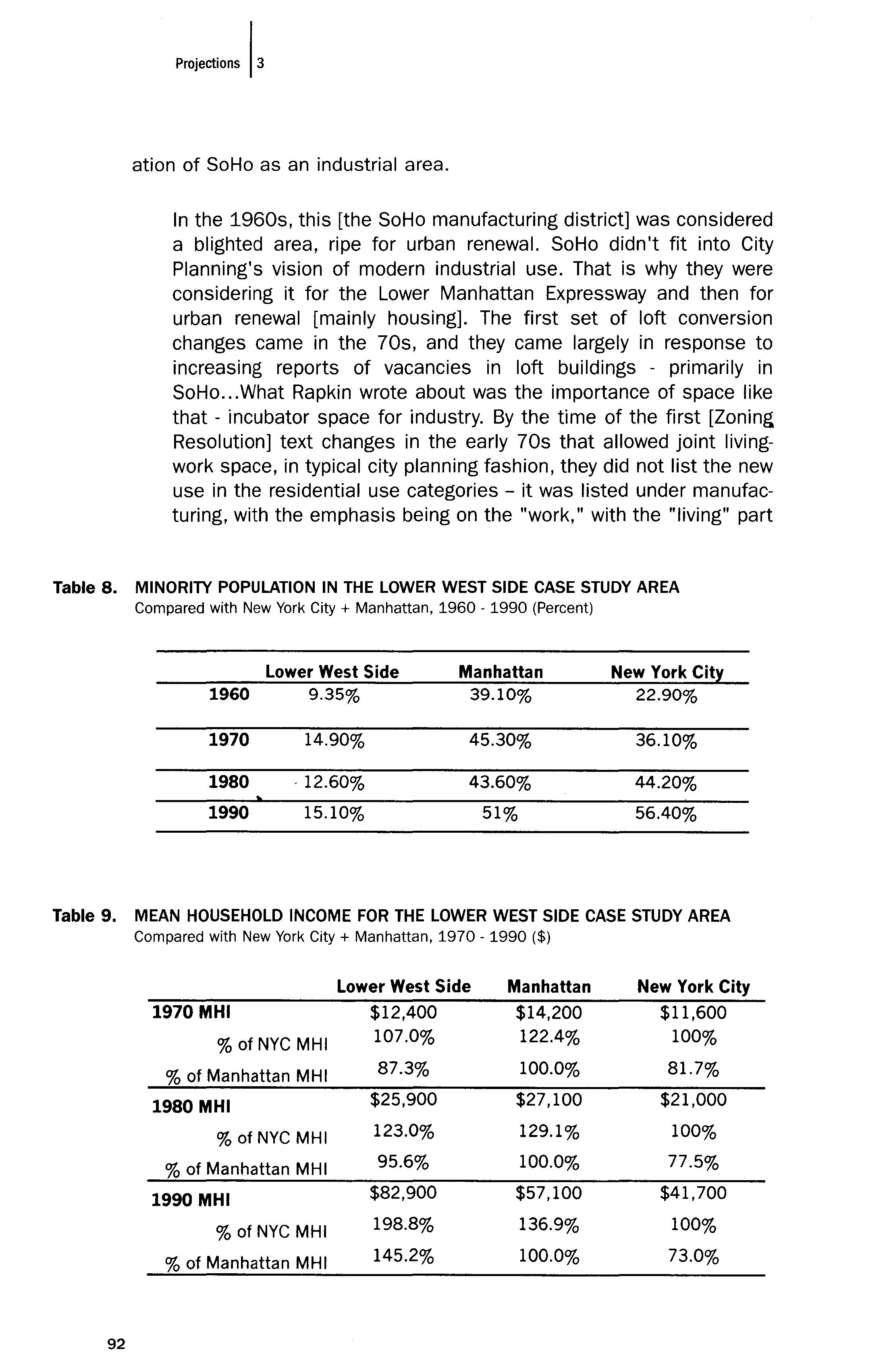
Compared with New York City + Manhattan, 1960 1990 (Percent)
Lower West Side Manhattan New York City 1960 9.35% 39.10% 22.90% 1970 14.90% 45.30% 36.10% 1980 ·12.60% 43.60% 44.20% 1990 15.10% 51% 56.40%
Table
92
9. MEAN HOUSEHOLD INCOME FOR THE LOWER WEST SIDE CASE STUDY AREA Compared with New York City + Manhattan, 1970 1990 ($) Lower West Side Manhattan New York City 1970 MHI $12,400 $14,200 $11,600 % of NYC MHI 107.0% 122.4% 100% % of Manhattan MHI 87.3% 100.0% 81.7% 1980 MHI $25,900 $27,100 $21,000 % of NYC MHI 123.0% 129.1% 100% % of Manhattan MHI 95.6% 100.0% 77.5% 1990 MHI $82,900 $57,100 $41,700 % of NYC MHI 198.8% 136.9% 100% % of Manhattan MHI 145.2% 100.0% 73.0%
incidental. And the image everyone had was of these enormous sculptures that were metal, so it was like a factory. That was the image, and rather naYve of the planners lronically, of course, the zoning that legitimized the loft living drove the prices up so that neither the intended artist residents nor the industrial tenants found the lofts affordable anymore (z.1. #5).
Many of the urban renewal plan documents express "the provision of housing" as a primary objective of their proposals. In practice, this amounted to a certain type of housing, one designed to meet the housing needs of people who already had abundant choices for housing outside the city, but seemingly not so many choices for housing inside the city. A letter from the Department of Housing and Urban Development (HUD) to the Chair of the City Planning Commission reiterated some of the reasons for their proposed Washington Street URA: "To provide a powerful new magnet for housing in the City's core area; to broaden its share of that part of the region's new housing market composed largely of younger households amenable to central city living ... " (October 26,1970 letter).
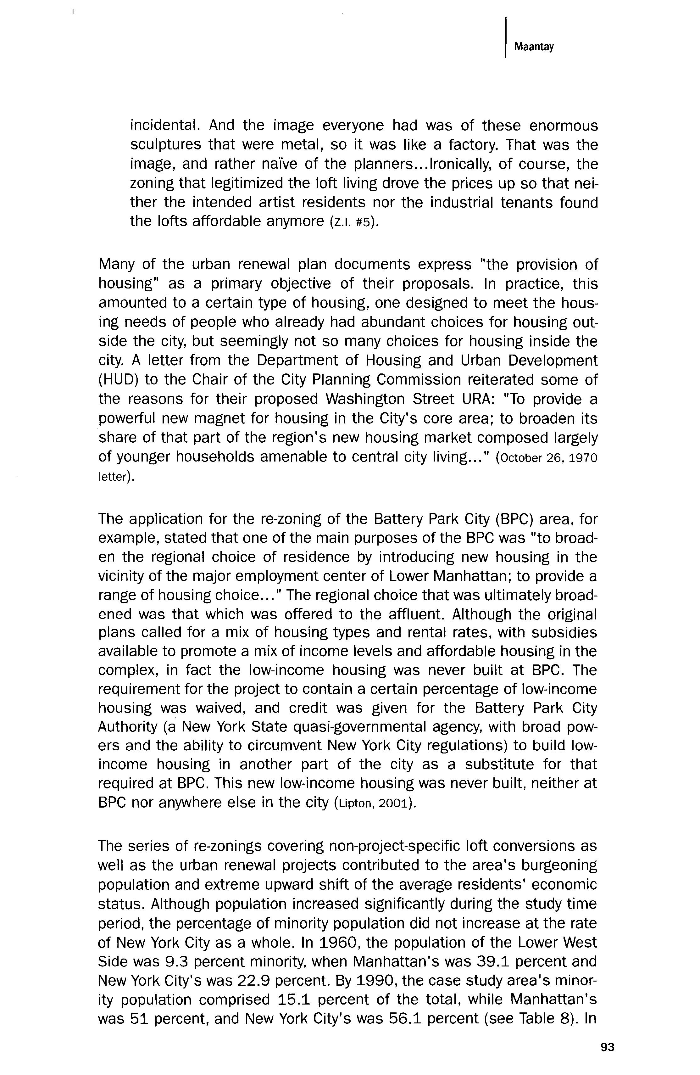
The application for the re-zoning of the Battery Park City (BPC) area, for example, stated that one of the main purposes of the BPC was "to broaden the regional choice of residence by introducing new housing in the vicinity of the major employment center of Lower Manhattan; to provide a range of housing choice " The regional choice that was ultimately broadened was that which was offered to the affluent. Although the original plans called for a mix of housing types and rental rates, with subsidies available to promote a mix of income levels and affordable housing in the complex, in fact the low-income housing was never built at BPC. The requirement for the project to contain a certain percentage of low-income housing was waived, and credit was given for the Battery Park City Authority (a New York State quasi-governmental agency, with broad powers and the ability to circumvent New York City regulations) to build lowincome housing in another part of the city as a substitute for that required at BPC. This new low-income housing was never built, neither at BPC nor anywhere else in the city (Lipton, 2001).
The series of re-zonings covering non-project-specific loft conversions as well as the urban renewal projects contributed to the area's burgeoning population and extreme upward shift of the average residents' economic status. Although population increased significantly during the study time period, the percentage of minority population did not increase at the rate of New York City as a whole. In 1960, the population of the Lower West Side was 9.3 percent minority, when Manhattan's was 39.1 percent and New York City's was 22.9 percent. By 1990, the case study area's minority population comprised 15.1 percent of the total, while Manhattan's was 51 percent, and New York City's was 56.1 percent (see Table 8). In
93
1960, residents' average family income was approximately 87 percent of that of Manhattan. By 1990, the average income was 145 percent of Manhattan's, making it one of the most affluent enclaves in Manhattan (see Table 9).
Land use also changed significantly over the course of the study time period. Industrial uses in the areas re-zoned from manufacturing to districts permitting housing had diminished visibly between 1956 and 1990, but industrial uses also diminished in areas adjacent to those re-zoned, but which remained officially M zones. Formerly industrial buildings were now shown on the Sanborn maps as residential uses for many of the older loft buildings.
The general land use policy trend in effect for virtually the entire study time period seemed to favor the development of housing and shopping amenities for the affluent, commercial office towers, and waterfront recreational uses, designed to appeal primarily to the resident and work-day office populations. The policies were intended to "liberate" the valuable land on the Lower West Side, away from New York City's downward sliding industrial base and towards what was seen as the future: the ascendancy of the consumer society. The underlying subtext of these policies stated the forecast and hope that this strategy would serve to jump start New York's failing economy, and reverse the distressing socio-economic changes that had taken place and continued to take place.
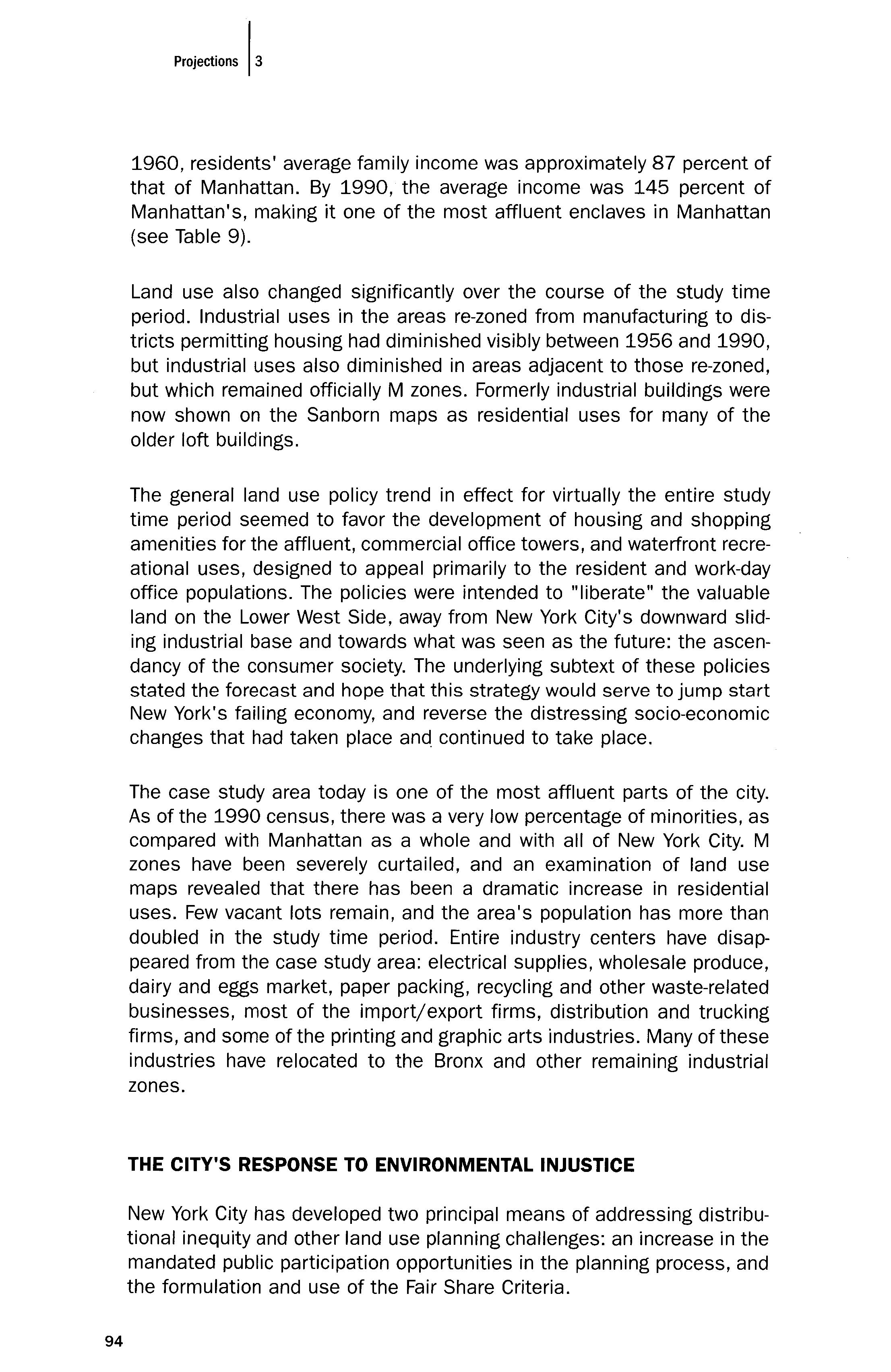
The case study area today is one of the most affluent parts of the city. As of the 1990 census, there was a very low percentage of minorities, as compared with Manhattan as a whole and with all of New York City. M zones have been severely curtailed, and an examination of land use maps revealed that there has been a dramatic increase in residential uses. Few vacant lots remain, and the area's population has more than doubled in the study time period. Entire industry centers have disappeared from the case study area: electrical supplies, wholesale produce, dairy and eggs market, paper packing, recycling and other waste-related businesses, most of the import/export firms, distribution and trucking firms, and some of the printing and graphic arts industries. Many of these industries have relocated to the Bronx and other remaining industrial zones.
THE CITY'S RESPONSE TO ENVIRONMENTAL INJUSTICE
New York City has developed two principal means of addressing distributional inequity and other land use planning challenges: an increase in the mandated public participation opportunities in the planning process, and the formulation and use of the Fair Share Criteria.
94 Pmjectioos I,
Community-based, or participatory, planning has been seen as a necessary, but not sufficient, means of achieving environmental justice. Although some view community-based planning as a way to empower the "underdogs" and alter the balance of power (Renn, Webler, & Wiedemann, 1995), community-based planning has also been thought of as promoting NIMBY-ism rather than promoting environmental justice. If each community has the right to make its own land use decisions, the result may be each community's plan rejecting the siting of all perceived LULUs within their community, based on the Not In My Back Yard philosophy, and in keeping with exclusionary zoning principles. The right to determine the direction of development in their community may translate into an unwillingness to accommodate any objectionable land use, even if it is a land use required to address the community's share of the burdens, such as the solid waste produced by the community. Additionally, a comprehensive plan for a city that is comprised solely of a collection of individual community plans ends up being piecemeal planning, by not addressing regional needs or larger city-wide land use issues.
New York City's 1990 revised Charter, Section 197(a), gave each Community District the opportunity to devise its own comprehensive community-scale plan. But this process is unlikely to result in enhanced environmental justice. The plans are difficult to develop, and are a lengthy and potentially contentious procedure. Therefore, few community districts have opted to make a community plan as yet, and many may never do so. The few community district plans that have been developed so far have been somewhat controversial, with no clear assurance at the end of the process that the plan actually reflects the community's visions. Added to this is the fact that the plans are strictly advisory, imparting no requirement for the Planning Commission or the City Council to abide by or implement them.
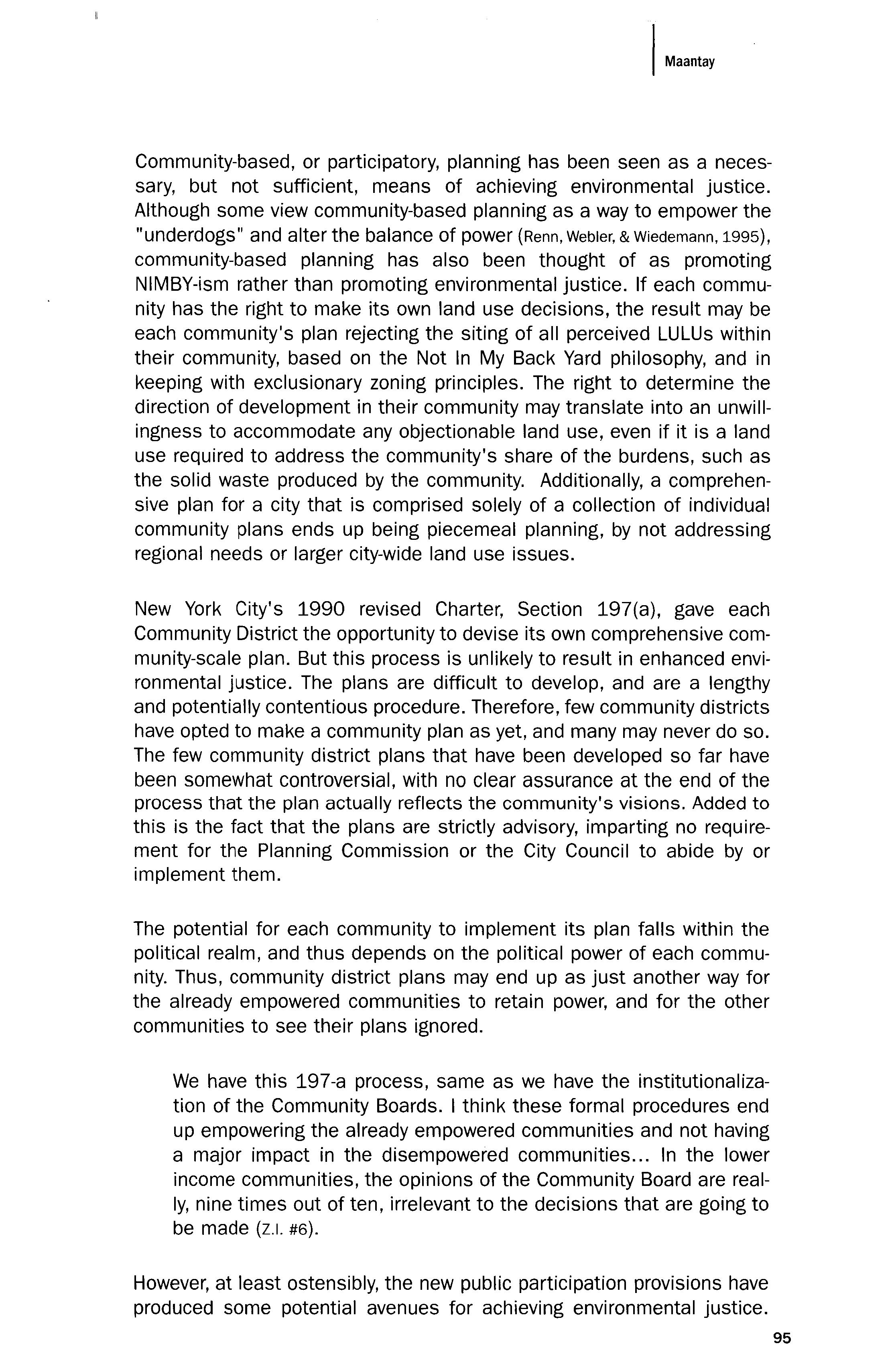
The potential for each community to implement its plan falls within the political realm, and thus depends on the political power of each community. Thus, community district plans may end up as just another way for the already empowered communities to retain power, and for the other communities to see their plans ignored.
We have this 197-a process, same as we have the institutionalization of the Community Boards. I think these formal procedures end up empowering the already empowered communities and not having a major impact in the disempowered communities... In the lower income communities, the opinions of the Community Board are really, nine times out of ten, irrelevant to the decisions that are going to be made (z.1. #6).
However, at least ostensibly, the new public participation provisions have produced some potential avenues for achieving environmental justice.
I Ma"laj
95
There are mandated opportunities for the public to comment on proposed actions, although, again, there is no requirement for the decision-makers to abide by the public's wishes. Nevertheless, they are supposed to take the community's viewpoint into consideration, and are often persuaded to do so by the negative political ramifications of going against the community. This is dependent on the visibility of the community, their political voice, and the media attention given to the issue. Planning decisions are also, however, subject to the shifting allegiances and alliances of the decision-makers in the Planning Commission and City Council, and often party or borough obligations and loyalties override other considerations in the vote.
Fair Share Criteria
The other major mechanism the city has developed to promote equity in the distribution of the benefits and burdens of city facilities is the Fair Share Criteria. The Fair Share Criteria (NYC OCp, 1991) are new procedures and standards for agencies to follow in the siting of city facilities. The new City Charter, Section 203(a), called for the mayor to promulgate rules for such procedures and standards. The Charter revisions were approved by the voters in 1989, and the Fair Share Criteria were created and became effective in 1991. The Criteria were developed in response to an on-going crisis encountered in the City's attempts to site locally-undesirable social service facilities and other types of city-owned or -operated facilities.
When the Fair Share Guidelines were first established, they were much touted in the planning field as being a positive step in the direction of environmental equity and locational conflict resolution. The American Planning Association gave New York City an award for the Fair Share guidelines because they were the best example of how "planning effectively addresses specific community needs" (Rose, 1993, p. 97). How well have the Fair Share Criteria addressed environmental justice issues in New York City?
There are some limitations inherent in the Fair Share Criteria that reduce their effectiveness in producing environmental justice outcomes. First, they only apply to city-owned, -operated, or -contracted facilities and programs, and as the city continues to privatize an increasing number of its functions, Fair Share becomes less of a protection for many communities against over-saturation of objectionable facilities. Many objectionable facilities are not even covered under the Criteria because of this limitation (e.g., solid waste transfer stations, which are predominantly private).
Secondly, the Criteria only require that decision-makers take the criteria "into account" in their deliberations on whether or not to approve a given siting action. There are no formulas, quotas, or prohibitions for siting cityowned facilities, and thus no clear-cut ways of ascertaining what the fair
96 Projections 13
share for a community actually should be or when a community is "oversaturated." "The criteria do not prohibit the siting of facilities in the 'high concentration' districts, but do require closer scrutiny of the effect of facility clustering on neighborhood character" (Weisberg, 1993, p. 95). Therefore, interpretation of the Fair Share Criteria is fairly subjective. How thoroughly Fair Share considerations are evaluated and taken into account in siting decisions varies considerably from agency to agency. DCP subsequently issued guidelines to help agencies interpret the Criteria when proposing sites for their facilities (New York City Department of City Planning, 1998), but each agency adheres to the Criteria in its own way, some more diligently and rigorously than others.
[F]or some agencies, the Criteria fulfill their intended function as a tool for careful analysis and disclosure of the potential impacts of a new facility on a neighborhood. For other agencies, the absence of a prescribed "roadmap" can allow for sloppy analysis and perfunctory consideration of difficult issues (Karnovsky, 2002, p. 43).
Ultimately, the major factor in evaluating the effectiveness of the Fair Share Criteria is what the purpose of Fair Share is perceived to be. Should the Criteria produce equitable outcomes, or merely provide an equitable process? Clearly, some planners and legal experts view the Criteria's purpose as being the provision of an equitable process, and view the Criteria as a success since they fulfill that objective.
The intent of Fair Share is to regularize the process, make it more open, and bring into it previously disenfranchised participants. It rests on the hope that by making more people responsible parties in the deal-making, the public perception of illegitimacy will be lessened. Further, by setting up the process in which participation is to be ensured, parties who fail or refuse to make use of the prescribed administrative channels will lose their legitimacy and, hopefully, their legal standing to bring subsequent challenge against siting decisions (Valletta, 1993, p. 20).
Regardless of how fair the process is, legitimacy will not be conferred if people believe that the outcome is a foregone conclusion and their participation has no impact on the decision. In fact, this may be counterproductive, because people will feel that they are being allowed to participate just to add a veneer of legitimacy to the proceedings, with no hope of influencing the outcome, and they will eventually stop participating (and lending their legitimizing influence). In other words, the goal ought not to be that the public perception of illegitimacy be lessened, but that we strive to lessen actual illegitimacy as well.
According to the City Planning Department's own evaluation of the Fair Share Criteria, (New York City Department of City Planning, 1995), the Criteria have
1M""",
97
not resulted in a more equitable distribution of LULUs; the most successful part of Fair Share has been the "advance warning" system embodied in the Annual Statement of Needs, whereby the public is notified of and has the opportunity to comment on agencies' proposals for facility sitings at an early stage in the site selection process. However valuable this turns out to be in achieving equitable siting solutions, it is reasonable to believe that most people view the purpose of Fair Share as preventing over-saturation of noxious uses in any given community, and not just providing public participation opportunities.
Perhaps including more specific guidelines in the Criteria would lead to greater distributional equity. Some would say that equitable distribution of noxious facilities is beside the point the goal of environmental justice is not to spread pollution and health risks around so that everyone is impacted equally, but to address the root of the problem: by lessening pollution and health risks for everyone, by questioning the need for many of the environmental burdens being generated, and by challenging assumptions about the modes of production and consumption in capitalist societies (Lake, 1993).
Still, the most salient problem with the Fair Share Criteria, especially in light of the discussion on zoning and zoning changes above, is the fact that the location and uneven distribution of M zones precludes many communities in New York City from ever bearing their share of the burden. The underlying zoning for industry is taken as a given in siting analyses. Many types of facilities covered by the Fair Share Criteria can only be sited in an M zone. For those communities and people living in close proximity to an M zone, then, Fair Share does little to alleviate the concentration of noxious facilities.
[T]he zoning map changed in the other boroughs, and the city never related the zoning map changes in the other boroughs to the impact that it would create in Hunts Point [in the Bronx]. If you eliminate manufacturing zoning in Manhattan, how then could that borough take its fair share of the burden? The DCP and the planning commission looked at M zones strictly as areas for manufacturing, rather than also acknowledging that they're the only areas that noxious uses of any sort can locate in. The idea of Fair Share becomes meaningless if a borough has little or no remaining M zones. They will try to stick anything they don't know what else to do with in an M zone. It is very inappropriate and ill-considered planning (z.1. #7).
In his critique of the Fair Share Criteria, Joe Rose says: "a fundamental goal of zoning has always been to isolate noxious uses from the general population. This usually entails concentrating noxious facilities in particular areas, precisely the opposite of what New York's Fair Share guidelines prescribe" (Rose, 1993, p. 100). Unfortunately, siting noxious uses in M
98 P<o)eeb,"s 13
Maao'a,
zones does NOT isolate them from the general population or not, at least, from the 22% of New Yorkers, predominantly poor and minority, who live in a census tract within a major M zone.
In fact, the key difference between Rabin's definition of expulsive zoning and the New York experience is that in New York, poor and minority people have not, by and large, necessarily been expelled by expansions of M zones, but continue to live in or near M zones having high concentrations of noxious uses. There is often no other place for them to move to within the city, especially given the amount of public housing that has been constructed in industrial areas. In this case, the zoning changes that increase noxious uses in a community would be more accurately termed "intensive" zoning rather than expulsive zoning (Arnold, 2000), although expulsive zoning still accurately describes what happens in New York when industrial areas are re-zoned to other uses, and poor and minority residents are forced out by gentrification.
Rose's primary complaint about the Fair Share Criteria is not their lack of specificity in determining "fairness," but the futility of trying to legislate fairness and of attempting to interject ethics into what is a difficult, political, and subjective balancing act of conflicting interests. However, based on my conversations with planners and policy-makers, many generally believe it is possible (and desirable) to legislate fairness (Maantay, 2000). In a way, that is what planning is all about: ensuring a high quality of life for all through the regulatory framework of zoning, environmental impact assessment, and other legal and policy approaches. In "Planning the Equitable City," R. Susan Motley contends that "[A]n equitable city can emerge only through a process that is equitable itself" (Motley, 1993, p. 208). For now, the equitable process must, to a large degree, be legislated.
Some states have woven environmental justice criteria into their environmental laws (Gross, Shafsky, & Brown, 2000), but these typically have to do with creating a more inclusive approval process for permit applications for noxious uses, assisting community members to participate in the regulatory process, or encouraging the equitable clean-up of already contaminated land. They do not get at the heart of the matter the zoning designations and zoning changes that permit a concentration of noxious uses near certain groups of people. Although increased opportunities for public participation, community-based planning, and (to a much lesser degree) the Fair Share Criteria have brought additional political pressure and media attention to bear on the issue of environmental injustice in New York City, other effective ways of dealing with land use inequities are available, and have been used elsewhere.
Craig Anthony (Tony) Arnold discusses some of these methods in "Planning Milagros: Environmental Justice and Land Use Regulation," as well as in this volume's "Land Use Justice." Other cities have tried dif-
I
99
ferent planning and zoning techniques, such as comprehensive re-zoning to include overlays with "conditional uses" for certain use groups (East Austin, Texas); buffer requirements separating industry and residences, and a permitting process for noxious uses where approvals can be denied based solely on a community's over-saturation with hazardous material storage, use, or manufacture (Denver, CO); and zoning text amendments barring certain land uses from the city altogether, such as metal shredders in St. Paul, Minnesota (Arnold, 1998; Arnold, 2000). Arnold advocates changing zoning texts rather than zoning maps, since courts tend to uphold text changes more often than map changes as evidence of comprehensive zoning, and text changes could be used to alter use groups within a type of zone without altering property lot designation or zone boundaries.
These flexible zoning techniques recognize that we must make industrial zones safer. By creating regulations that force industrial neighborhoods to pursue a higher standard of environmental quality and by introducing flexible zoning techniques, improved performance standards for industry, and sensible mixed-use zoning designations, expulsive zoning problems can be addressed through: 1) stemming the tide of extreme racial segregation in industrial zones, which affects industrial areas that have been targeted to be dumping grounds for noxious uses; and 2) discouraging expulsion of minorities and industries from industrial areas that have been targeted by planners and private investors for gentrification.
CONCLUSION
Zoning as practiced in New York City is not a benign or neutral process. Decisions about the best locations for noxious uses have racial and class implications, since M zones are the only places in New York where noxious uses can be sited, and the people living in and near M zones have a much higher than average likelihood of being poor and minority. Areas where M zones are increased in extent are more likely to have a higher than average proportion of minorities and lower-income people, while areas where M zones are decreased often have a lower proportion of minority and lower-income people. As the city has re-zoned many areas from M to other uses, industrial uses have become intensified in the remaining M zones. The re-zoning of vast areas of the Lower West Side from M to other uses is not unrelated to the city's need to re-zone areas of the Bronx from residential to manufacturing.
We cannot say that the city purposely selected poor and minority communities as "appropriate" places to increase industry and noxious uses. Nor can we say that the city purposely selected more affluent and "whiter" industrial areas as "appropriate" places to discourage industry and begin gentrification. But, issues of intentionality aside, we must acknowledge the role of city planning in reducing some people's quality
100 Pmj,,,"o", /'
of life and improving others', while ostensibly promoting equal protection under the law of zoning.
I spoke with many people about my study, both planning professionals and laypeople from a wide variety of backgrounds, and the response, almost invariably, was something along the lines of: "So, what else is new? Poor people live in lousy places. That's the way the world is. There has to be some land allocated for industry and unpleasant things, and those things are definitely not going to be put near rich people!" Unfortunately, expulsive zoning has become so naturalized in our society (even among some of the planners with whom I spoke) that few people think it noteworthy that planning policy and the law of zoning differentially protect communities behind a mask of scientific objectivity and the ideals of justice implied in an equal application of the law.
No question that zoning protects some people better than others. Zoning is responsive to wealth, property, political power, and those areas or communities that are more politically empowered or connected clearly will be able to get done the zoning changes that they desire and to prevent the zoning changes they don't desire. Less politically or economically empowered communities, even though you have a formal structure [for public participation], will be less able to impact on changes that are taking place to them or around them (Z.I. #6).
Of course zoning doesn't protect equally but this is just part and parcel of our negative attitudes towards both industry and poor people Zoning segregates not just land use, but also people. Zoning is best at protecting areas of one- and two-family homes. Zoning protects areas of home ownership. It protects areas of higher land values. These areas need to be protected because, reading between the lines, these are presumably the people who need to be most protected (Z.I. #1).
Zoning is perceived as the law is: scientific-based and justice-oriented. Zoning is supposed to be impartial, even-handed. We assume that zoning, being part of our body of law, affords justice, but the purpose of zoning is not to provide justice, but to protect some more than others, based on the value of land, and by inference, the value of people. Zoning as we have it perpetuates a stratified economy (Z.I. #3).
Everyone does not get equal protection [from zoning]. It simply isn't possible to provide that to everyone (Z.I. #2).
Zoning is the determinant in decisions about where the city continues to site (or allows to be sited) noxious uses. Zoning tends to concentrate
1M."..,
101
noxious uses in poor and minority industrial neighborhoods due to re-zoning of more affluent and less minority industrial neighborhoods to other uses. As long as "market forces" govern zoning and, therefore, planning, in New York, this concentration of noxious uses in poorer and more minority areas will result. When the main purpose of planning is viewed as the facilitation of market trends, the concentration of noxious uses in poor neighborhoods is inevitable. When planning tries to address quality-of-life issues in low-income populations, this concentration is less inevitable. Perhaps the first step in rectifying the inequitable city, and planning a livable city for all, would be to acknowledge the role zoning can play in perpetrating and perpetuating the disproportionate concentration of noxious land uses and the resulting environmental burdens in some locations and for some people.
REFERENCES
Abrams, C. (1971). Forbidden neighbors. Port Washington, NY: Kennikat Press.
Adams, I K. (1992). Census of population and housing, 1960, 1970, and 1980 extract data. Ann Arbor: Inter-University Consortium for Political and Social Research.
Anderson, M. (1964). The federal bulldozer: A critical analysis of urban renewal, 1949-1962. Cambridge, MA: MIT Press.
Arnold, C. A. (1998). Planning milagros: Environmental justice and land use regulation. Denver University Law Review, 76(1), 1-153.
Arnold, C. A. (2000). Land use regulation and environmental justice. Environmental Law Reporter, 6, 10395-10433.
Babcock, R. (1966). The zoning game. Madison: University of Wisconsin Press.
Bassett, E. (1936). Zoning. New York: Russell Sage Foundation.
Been, V. (1994). Locally undesirable land uses in minority neighborhoods: Disproportionate siting or market dynamics? Yale Law Journal, 103, 1383-1422.
Been, V., & Gupta, F. (1996). Coming to the nuisance or going to the barrios? A longitudinal analysis of environmental justice claims. Ecology Law Quarterly, 24(1), 1-35.
Boer, J. I, Pastor, M., Jr., Sadd, J. L., & Synder, L. D. (1997). Is there environmental racism? The demographics of hazardous waste in Los Angeles County. Social Science Quarterly, 78(4), 793-810.
Bowen, W. M., Salling, M. J., Haynes, K. E., & Cyran, E. J. (1995). Towards environmental justice: Spatial equity in Ohio and Cleveland. Annals of the Association of American Geographers, 85(4), 641-663.
Branfman, E., Cohen, B., & Trubek, D. (1974). Measuring the invisible wall: Land use controls and residential patterns of the poor. In D. Listokin (Ed.), Land Use Controls (pp. 57-82). New Brunswick, NJ: Rutgers University Center for Urban Policy Research (CUPR).
Bressi, I (Ed.). (1993). Planning and zoning in New York City. New Brunswick, NJ: Rutgers University Center for Urban Policy Research (CUPR).
102
I,
Pmj.eh,",
Bronx Borough President's Solid Waste Management Task Force. (1997). Solid waste management plan. Bronx, NY: Office of the Bronx Borough President.
Bryant, B. (Ed.). (1995). Environmental justice: Issues, policies, and solutions. Washington, DC: Island Press.
Bullard, R. D. (Ed.). (1994). Unequal protection: Environmental justice and communities of color. San Francisco: Sierra Club Books.
Burke, L. M. (1993). Race and environmental equity: A geographic analysis in Los Angeles. Geo Info Systems, 3, 44-50.
Camacho, D. E. (Ed.). (1998). Environmental injustices, political struggles: Race, class, and the environment. Durham, NC: Duke University Press.
Caro. R. (1974). The power broker: Robert Moses and the fall of New York. New York: Vintage.
Centner, 1, Kriesle, w., & Keeler, A. G. (1996). Environmental justice and toxic releases: Establishing evidence of discriminatory effect based on race and not income. The Wisconsin Environmental Law Journal, 3(2),119-158.
Dubin, J. (1993). From junkyards to gentrification: Explicating a right to protective zoning in low-income communities of color. Minnesota Law Review, 77, 739-801.
Freund, E. (1904). The police power: Public policy and constitutional law. Chicago: Callaghan.
Glickman,l S., & Hersh, R. (1995). Evaluating environmental equity: The impacts of industrial hazards on selected social groups in Allegheny County, Pennsylvania. Discussion Paper 9513. Washington, DC: Resources for the Future.
Goldman, B. A. (1993). Not just prosperity: Achieving sustainability with environmental justice. Washington, DC: National Wildlife Foundation.
Greenberg, M. (1993). Proving environmental inequity in siting locally unwanted land uses. Journal of Risk Issues in Health and Safety, 4(3), 235-252.
Gross, H., Shafsky, H., & Brown, K. (2000, December). Environmental justice: A review of state responses. Report prepared by the Public Law Research Institute, Hastings College of Law. Accessed June 27, 2002 on web site: www.opr.ca.govjejusticejejinformation.shtml.
Haar, C., & Kayden, J. (1989). Zoning and the American dream: Promises still to keep. Chicago: Planners Press, American Planning Association.
Haar, C., & Wolf, M. (1989). Land use planning the use, misuse, and reuse of urban land. Boston: Little, Brown.
Haggerty, M. (1996). Crisis at Indian Creek. In R. Bullard (Ed.). Unequal protection: Environmental justice and communities of color (pp. 23-42). San Francisco: Sierra Club Books.
Harrison, Ballard and Allen. (1950, October). Plan for rezoning the City of New York. New York, NY.
Head, R. A. (1995). Health-based standards: What role in environmental justice? In B. Bryant (Ed.), Environmental justice: Issues, policies, and solutions (pp. 45-56). Washington, DC: Island Press.
Higgins, R. R. (1993). Race and environmental equity: An overview of the environmental justice issue in the policy process. Polity, 26(2), 281-300.
103
Jacobs, J. (1961). The death and life of great American cities. New York: Random House.
Johnston, B. R., (Ed.). (1994). Who pays the price? The sociocultural context of environmental crisis. Washington, DC: Island Press.
Karnovsky, D. (2000a). Fair share: New York City's experiment in equitable siting of city facilities and its relationship to environmental justice, Part I. Environmental Law in New York, 13(3), 37-44.
Karnovsky, D. (2000b). Fair share: New York City's experiment in equitable siting of city facilities and its relationship to environmental justice, Part II. Environmental Law in New York, 13(4), 57-61.
Lake, R. (1993). Rethinking NIMBY. Journal of the American Planning Association, 59(1), 8793.
Lauber, D. (1974). Recent cases in exclusionary zoning. In: D. Listokin (Ed.), Land use controls (pp. 177-178). New Brunswick, NJ: Rutgers University Center for Urban Policy Research.
Levy, J. (1974). Exclusionary zoning: After the walls came down. In: D. Listokin (Ed.), Land use controls (pp. 79-81). New Brunswick, NJ: Rutgers University Center for Urban Policy Research.
Lipton, E. (2001, January 2). Battery Park City is success, except for pledge to the poor. The New York Times, B1.
Maantay, J. A. (2000). Industrial zoning changes and environmental justice in New York City: An historical, geographical, and cultural analysis. Doctoral dissertation. New Brunswick, NJ: Rutgers University.
Maantay, J. A. (2001a). Race and waste: Options for equity planning in New York City. Planners Network, 145(1), 6-10.
Maantay, J. A. (2001b). Zoning, equity, and public health. American Journal of Public Health 91, 1033-1041.
Maantay, J. A. (2002a). Mapping environmental injustices: Pitfalls and potential of Geographic Information Systems (GIS) in assessing environmental health and equity. Environmental Health Perspectives, 110 (suppl. 2), 161-171.
Maantay, J. A. (2002b). Mapping asthma incidence and environmental hazards in the Bronx. Unpublished study.
Maantay, J. A., Timander, L., Graziosi, G. H., & Meyer, L. (1997). The Bronx toxic release Report. New York: The Center for a Sustainable Urban Environment and the United States Environmental Protection Agency, Region 2.
Makielski, S., Jr. (1966). The politics of zoning: The New York experience. New York: Columbia University Press.
Mandelker, D. R. (1971). The zoning dilemma: A legal strategy for urban change. Indianapolis, IN: Bobbs-Merrill.
Massey, D. S., & Denton, N. A. (1993). American apartheid: Segregation and the making of the underclass. Cambridge, MA: Harvard University Press.
Miller, D., & de Roo, G. (1996). Integrated zoning: An innovative Dutch approach to measuring and managing environmental spillovers in urban regions. Journal of the American Planning Association, 62, 373-380.
104
Mohai, P., & Bryant, B. (1992). Environmental injustice: Weighing race and class as factors in the distribution of environmental hazards. University of Colorado Law Review, 63, 921932.
Motley, R. S. (1993). Planning the equitable city. In T. Bressi (Ed.), Planning and zoning in New York City. New Brunswick, NJ: Rutgers University Center for Urban Policy Research.
National Committee Against Discrimination in Housing and the Urban Land Institute. (1974). Fair housing and exclusionary land use. Urban Land Institute Research Report No. 23. Washington, DC: Urban Land Institute.
National Research Council. (1997). Environmental epidemiology: Use of the Gray literature and other data in environmental epidemiology. Washington, DC: National Academy Press.
Neumann, C. M., Forman, D. L., Rothlein, J. E. (1998). Hazard screening of chemical releases and environmental equity analysis of populations proximate to toxic release inventory facilities in Oregon. Environmental Health Perspectives, 106(4}, 217-226.
New York City Board of Estimate and Apportionment. (1916). New York City Zoning Regulations, July 25, 1916.
New York City Department of City Planning. (1961). New York City Zoning Resolution, December 15, 1961, and periodic updates until the present.
New York City Department of City Planning. (1961-1998). Map Sections 1-35, archival zoning change maps. (On file at the Department of City Planning.)
New York City Department of City Planning. (1982). The Mid-Bronx Industrial Park urban renewal plan, January 1982. New York: Department of City Planning.
New York City Department of City Planning. (1985). Plans, programs, and policies 19801985. New York: Department of City Planning.
New York City Department of City Planning. (1985, May). SoHo/NoHo occupancy survey 1983. New York: Department of City Planning.
New York City Department of City Planning. (1991). Locating city facilities: A guide to the "Fair Share" criteria. New York: Department of City Planning.
New York City Department of City Planning. (1992, Fall). Northern Bathgate: Neighborhood land disposition plan. New York: Department of City Planning.
New York City Department of City Planning. (1993). Citywide industry study: Geographical atlas of industrial areas. New York: Department of City Planning.
New York City Department of City Planning. (1993). Crotona Park North/Bronx Park South: Neighborhood land disposition plan. New York: Department of City Planning. Fall 1993.
New York City Department of City Planning. (1993). Citywide industry study: Zoning technical report. New York: Department of City Planning.
New York City Department of City Planning. (1995). Fair Share: An assessment of New York City's facility siting process. New York: Department of City Planning.
New York City Department of City Planning. (1998). Fair Share criteria: A guide for city agencies. New York: Department of City Planning.
New York City Planning Commission, (1940). Master plan of adoption of city-wide map showing sections containing areas for clearance, replanning, and low-rent housing. Prepared by the Division of Master Plan.
I Maantay
105
New York City Planning Commission/Sanborn Map Company. (1956, 1980, 1990). Land use maps of New York City, 1956, 1980, and 1990. New York Public Library, 42nd Street Map Archives.
New York City Planning Commission. (1963). The South Houston industrial area: A study of the economic significance of firms, the physical quality of buildings, and the real estate market in an old loft section of Lower Manhattan. New York: New York City Planning Commission.
New York City Planning Commission. (1969). Master plan for New York City: Critical issues, Volume 1. New York: New York City Planning Commission.
New York City Planning Commission. (1969). Master plan for New York City, Volumes 2-6, Manhattan, Brooklyn, Queens, Staten Island, and the Bronx. New York: New York City Planning Commission.
New York City Planning Commission. (1981, February). Lofts: Balancing the equities. New York: New York City Planning Commission.
New York City Planning Commission. (1990). Criteria for the location of city facilities. December 3, 1990. New York: New York City Planning Commission.
New York City Planning Commission. (1993, Spring). Shaping the city's future: New York City planning and zoning report. New York: New York City Planning Commission.
New York State Freedom of Information Law, Public Officers Law, art. 6,84-90.
Nordenstam, B. J. (1995). Transformation of grassroots environmental justice into federal agency environmental policy. In Environmental Science and Engineering Fellow Program, 1995 Reports (pp. 51-65). Washington, DC: American Association for the Advancement of Science.
Nossiter, A. (1995, March 5). Asthma common and on the rise in crowded South Bronx. The New York Times, Ai.
Novotny, P. (1998). Popular epidemiology and the struggle for community health in the environmental justice movement. In D. Faber, (Ed.), The Struggle for Ecological Democracy (pp. 137-158). New York: The Guilford Press.
O'Connor, T. (1993). Building a new Boston: Politics and urban renewal 1950-1970. Boston: Northeastern University Press.
Perlin, S. A., Setzer, R. W., Creason, J., & Sexton, K. (1995). Distribution of industrial air emissions by income and race in the United States: An approach using the toxic Release Inventory. Environmental Science Technology, 29(1),69-80.
Platt, R. (1991). Land use control: Geography, law, and public policy. Englewood Cliffs, NJ: Prentice Hall.
Pollock, P. H., & Vittas, M. E. (1995). Who bears the burden of environmental pollution? Race, ethnicity, and environmental equity in Florida. Social Science Quarterly, 76(2), 294309.
Power, G. (1983). Apartheid Baltimore style: The residential segregation ordinance of 19101913. Maryland Law Review, 42, 296-301.
Rabin, Y. (1989). Expulsive zoning: The inequitable legacy of Euclid. In C. Haar & J. Kayden (Eds.), Zoning and the American dream: Promises still to keep. Chicago: Planners Press, American Planning Association.
Renn, 0., Webler, T., & Wiedmann, P. (Eds.). (1995). Fairness and competence in citizen partiCipation. Dordrecht, Netherlands: Kluwer Academic.
106 Projections 13
Rose, J. (1993). A critical assessment of New York City's Fair Share Criteria. Journal of the American Planning Association, 59(1), 97-100.
Schwartz, J. (1993). The New York approach: Robert Moses, urban liberals, and redevelopment of the inner city. Columbus, OH: Ohio University Press. '
Silver, C. (1997). The racial origins of zoning in American cities. In J. Thomas and M. Ritzdorf (Eds.), Urban planning and the African American community: In the shadows. Thousand Oaks, CA: Sage Publications.
Stretesky, P., & Lynch, M. J. (1999). Environmental justice and the predictions of distance to accidental chemical releases in Hillsborough County, Florida. Social Science Quarterly, 80(4), 830-846.
Toll, S. (1969). Zoned American. New York: Grossman Publishers.
United Church of Christ's Commission for Racial Justice. (1987). Toxic wastes and race in the United States: A national report on the racial and socio-economic characteristics of communities with hazardous waste sites. New York: United Church of Christ.
United States Department of Commerce, Bureau of the Census. (1990). Census of population and housing, 1990 summary tape file on CD-ROM, technical documentation. Washington, DC: Bureau of the Census, United States Department of Commerce
United States Department of Commerce, Bureau of the Census. (1980). 1980 summary tape file 3a technical documentation. Washington, DC: U.S. Government Printing Office.
Valletta, W. (1993). Siting public facilities on a Fair Share basis in New York City. The Urban Lawyer, 25(1), 1-20.
Voorhees, Walker, Smith and Smith. (1958, August). Zoning New York City: A proposal for a zoning resolution for the City of New York. New York, NY.
Vose, C. E. (1959). Caucasians only: The Supreme Court, the NAACp, and the restrictive covenant cases. Berkeley, CA: University of California Press.
Weisberg, B. (1993). One city's approach to NIMBY: How New York City developed a Fair Share siting process. Journal of the American Planning Association, 59(1), 93-97.
Wernette, D. R., & Nieves, L. A. (1992, Marchi April). Breathing polluted air: Minorities are disproportionately exposed. The EPA Journal, 16-17.
Williams, N., Jr., & Norman, T. (1974). Exclusionary land use controls: The case of North Eastern New Jersey. In D. Listokin (Ed.), Land use controls: Present problems and future reform (pp. 105-130). New Brunswick, NJ: Rutgers University Center for Urban Policy Research.
Willis, C. (1993), How the 1916 zoning law shaped Manhattan's central business districts. In T. Bressi (Ed.), Planning and zoning in New York City (pp. 3-26). New Brunswick, NJ: Rutgers University Center for Urban Policy Research.
Wright, B., Bryant, P., & Bullard, R. (1996). Coping with poisons in Cancer Alley. In: R. Bullard (Ed.), Unequal protection: Environmental justice and communities of color (pp. 110-129). San Francisco: Sierra Club Books.
ENDNOTES
1 The difference between process equity (or procedural fairness) and outcome equality is a very important distinction to make in planning, since the way policy-makers have responded
1M..'..,
107
to accusations of environmental injustice has primarily been to create additional public participatory processes, Fair Share Guidelines, and other mechanisms to ensure "fairness" in siting noxious facilities. However, recent history has shown that process equity has not necessarily resulted in more equitable outcomes.
2 Appropriateness is a rather vague, catch-all term, implying conformance with currently accepted planning standards and goals, compatibility with existing or desired land use patterns, or the city's Master Plan, if there is one in effect. For example, changes to the zoning resolution and zoning maps require the New York City Planning Commission (CPC) to find that proposed re-zoning reflects "appropriate zoning" for the area in question. A substantial amount of subjectivity creeps into this decision-making process regarding what constitutes "appropriate" land use for a given part of the city. While the term "appropriate" is rarely defined, it appears as a justification in virtually every re-zoning application and CPC decision, as well as many planning studies and policy documents (Maantay, 2000).
3 Geographic Information Systems (GIS) refer to the combination of computer hardware, specialized software, spatial and non-spatial attribute databases, and "people power" required to conduct spatial analyses and computerized mapping. By overlaying individual layers of spatial and attribute data (for instance, a layer showing the locations of manufacturing zones and a layer of demographic data by census tracts), the GIS analyst can extract the characteristics of the population within a given distance of the M zones. This analysis would be extremely laborious, if not impossible, to accomplish manually, especially given the large data sets involved and amount of areal and statistical calculations required. The GIS software permits summaries of statistics for various levels of data aggregation, e.g. for the entire city, by borough, by M zones, by census tracts, etc. Unions (the Boolean operator OR) and Intersects (the Boolean operator AND) can be performed on multiple data layers to examine possible spatial correspondence and association between variables, and to select portions of data sets meeting certain criteria. These types of analyses are only practicable with GIS.
4 The term "minority group" refers to the population that is not Non-Hispanic White. Many people consider the term "minority" to be a misnomer, because in many US urban areas, as in New York City, people classified as minorities actually constitute the majority. Based on the census definitions, and the guidelines established in Federal Statistical Directive No. 15 issued by the Office of Management and Budget in 1992, which provides standards on ethnic and racial categories for statistical reporting to be used by all federal agencies, this study used a derived variable of "Minority." This category (for 1990 census data) is a summation of Hispanic, Non-Hispanic Black, Non-Hispanic American Indian, Non-Hispanic Asian or Pacific Islander, Eskimo or Aleut, and Non-Hispanic Other Race. Other federal agencies, such as the US Environmental Protection Agency, construct a similar "Minority" category as above for their research on environmental justice issues. Because this study required a longitudinal analysis, census data from 1960 through 1990 were used. One of the problems with cross-census comparisons is the lack of consistency in many census attribute data categories over the years, especially with data on race and ethnicity. Variables, methods of data aggregation, types of information collected, and census policies on issues such as confidentiality, differ from one census to the next, potentially affecting the validity of cross-census comparisons.
5 Quotations from the zoning experts used throughout this article are attributed to numbered Zoning Interviewees, abbreviated as Z.1. #1, Z.1. #2, etc., in order to preserve the anonymity requested by some of the interviewees. The complete list of interviewees and their affiliations is given in Appendix B, Maantay, 2000.
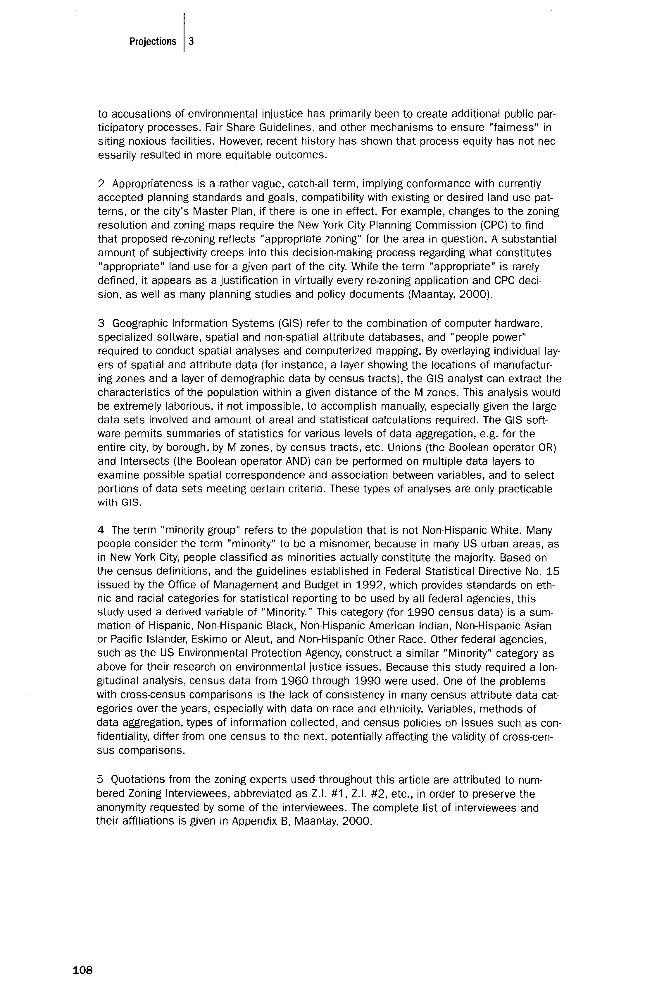
108
SOLVING
ENVIRONMENTAL INJUSTICES IN
MASSACHUSETTS: Forging Greater Community Participation in the Planning Process
DANIEL R. FABER Northeastern University Department of Sociology + Anthropology PENN LOH Alternatives for Community + Environment JAMES JENNINGS Tufts University Department of Urban + Environmental Policy + Planning

ABSTRACT
In the Commonwealth of Massachusetts, ecologically hazardous sites and facilities, ranging from highly polluting power plants to toxic waste dumps, are disproportionately located in communities of color and working-class communities. In fact, 9 of the 15 most environmentally overburdened towns in Massachusetts are low-income communities (where median household income is less than $30,000). Likewise, 9 of the 15 most environmentally overburdened towns in the state are of "higher-minority" status (where 15% or more of the population are people of color). In fact, citizens residing in a community of color in Massachusetts are 19 times more likely to live in one of the 25 most environmentally overburdened communities in the state. Striking inequities in the distribution of these sites and facilities are placing lower-income families and people of color at substantially greater risk of exposure to environmental health hazards. In response to these disparities, a vibrant environmental justice movement has emerged in Massachusetts. Aimed at organizing and mobilizing community residents to "act and speak for themselves," these environmental justice organizations are playing a pivotal role in organizing and mobilizing residents to be active participants in the planning and regulatory process. This article will highlight key lessons for planners around making community participation an effective tool for equity struggles, focusing on the role of Alternatives for Community and Environment (ACE) in the Boston neighborhood of Roxbury.
"The people shall have the right to clean air and water, freedom from excessive and unnecessary noise, and the natural, scenic, historic, and esthetic qualities of their environment; and the protection of the people in their right to the conservation, development, and utilization of the agricultural, mineral, water, air and other natural resources is hereby declared to be a public purpose."
- Constitution of the Commonwealth of Massachusetts
While the quality of life for all citizens in the United States is currently compromised by a number of serious environmental and human health problems, not all segments of the citizenry are impacted equally. As reported by Boone and Modarres (1999) in California, "Environmental hazards, like minority populations, are not distributed evenly in cities. Often, poor and minority communities are burdened with a disproportionate share of environmental· problems" (p. 164). And Greenberg, Lowrie, Solitare, and Duncan (2000) report about the imbalanced environmental quality of life in New Jersey's cities and brownfields: "Strong differences exist with regard to socioeconomic status and race municipalities with the most severe TOADS (Temporarily Obsolete Abandoned-Derelict Sites) have the poorest populations, the least expensive housing, and the lowest proportion of white residents" (p. 726).
One explanation for this situation is that, in order to bolster profits and competitiveness, industries adopt pollution strategies which are not only more economically efficient but that also offer the path of least political resistance. In the United States, it seems the less control capacity (or political power) a community possesses, the fewer resources a community has to defend itself from potential abuses, the lower the level of community awareness and mobilization against potential ecological threats, and the more minimal the processes of genuine citizen participation in community planning and regulatory decision-making processes the more likely they are to experience arduous environmental and human health problems at the hands of government and industry (Gould, 1998; Faber, 1998). A 1984 report prepared by the consulting firm Cerrell Associates for the California Waste Management Board, for instance, openly recommended that industries and the state locate hazardous waste facilities in "lower socio-economic neighborhoods" because those communities had a much lower likelihood of offering political opposition (Cerrell Associates, 1984). As a result, environmentally hazardous sites and facilities ranging from toxic waste dumps to polluting industrial plants, incinerators, power stations, landfills, etc., are disproportionately located in marginalized communities of color and lower-income communities across the nation (Bullard, 1994; Faber, 1998).
Residents of these communities must therefore live each day with substantially greater risk of exposure to environmental health hazards than

110 Proj"'"'" I,
the general citizenry. This is not to say that white and middle-to-upperincome communities have been bypassed by industrial pollution. But in contrast to the types of economic and social constraints confronting people of color and white working-class families, higher-income salaried and professional workers can often afford access to ecological amenities and a cleaner environment in non-industrial urban, suburban, and rural areas. In fact, working-class families and people of color face a "triple unequal exposure effect" to toxic pollution and other environmental hazards in comparison with higher-income residents. For lower-income communities and communities of color, this takes the form of exposure to: (1) greater concentrations of polluting industrial facilities and power plants; (2) greater concentrations of hazardous waste sites and disposal/treatment facilities, including landfills, incinerators, and trash transfer stations; and (3) higher rates of "indoor" exposure to pollutants inside the factory, as well as deteriorating schools and substandard housing (Bullard, 1994; Faber, 1998). Government enforcement and cleanup efforts are also typically uneven (Lavelle & Coyle, 1992). 1 Unequal exposure to environmental hazards is thus experienced by low-income and people of color populations in terms of where they work, live, and play (Alston, 1991).
Environmental disparities are pronounced in the Commonwealth of Massachusetts. For instance, there are over 21,038 hazardous waste sites in Massachusetts, including 3,389 of the more serious Tier I-II sites and 32 Superfund sites, according to March 2000 Department of Environmental Protection (DEP) data (Faber& Krieg, 2002). For residents living near Superfund and other major toxic waste sites, the National Research Council has found a disturbing pattern of elevated health problems, including heart disease, spontaneous abortions and genital malformations, and death rates, while infants and children are found to suffer a higher incidence of cardiac abnormalities, leukemia, kidney-urinary tract infections, seizures, learning disabilities, hyperactivity, skin disorders, reduced weight, central nervous system damage, and Hodgkin's disease (National Research Council, 1991). Elevated rates of leukemia (especially among children) have been linked to the industrial chemical trichloroethylene found in the Massachusetts town of Woburn's drinking water (as portrayed in the film A Civil Action), as well as tetrachloroethylene in drinking water on Upper Cape Cod (Aschengrau et aI., 1993, pp. 284-292).
As documented in Faber and Krieg's recent report Unequal Exposure to Ecological Hazards: Environmental Injustices in the Commonwealth of Massachusetts, communities of color and low-income communities experience a far more profound exposure rate to DEP hazardous waste sites than do higher-income and/or white communities, indicating that race and class appear to be significant factors in determining the location of both serious (Tier I-II) and less serious (Non-Tier) hazardous waste sites (Faber & Krieg, 2002). Low-income communities average nearly 14 hazardous waste sites per square mile. In contrast, higher-income communities,

IF,b et"
111
where the household median income is $30,000 or greater, average 3.1 to 4.1 hazardous waste sites per square mile. "High-minority" communities, where 25% or more of the population are represented by people of color, average 27.2 DEP hazardous waste sites per square mile. "Lowminority" «5% minority) communities average 2.9 hazardous waste sites per square mile. "High-minority" communities average more than nine times the number of hazardous waste sites per square mile than "Iowminority" communities.
Working-class communities and communities of color also bear a significantly greater portion of the pollution emitted by large industrial facilities. According to data collected under the Massachusetts Toxics Use Reduction Act (TURA) Program from 1990-98, some 1,029 distinct TURA facilities statewide produced 164,385,598 pounds of chemical waste byproduct (pollution) that was released on-site directly into the environment (discharged into the air, ground, underground, or adjacent bodies of water in the communities in which they were located). This is an amount equivalent to the weight of the Titanic ocean liner (Faber & Krieg, 2002). Lowincome communities (average household median income of less than $30,000) averaged some 73,061 total pounds of chemical emissions per square mile. This contrasts sharply with higher-income communities (average household median income of $40-49,999 or more), which averaged 10,937 to 12,502 pounds of chemical emissions per square mile.

Communities of color are also overburdened by industrial pollution. Higher-minority status communities (where 25% or more of the population are people of color) averaged 110,718 to 123,770 pounds of chemical emissions per square mile, compared to 22,735 pounds of chemical emissions per square mile for "low-minority" communities (Faber & Krieg, 2002). Thus, in comparison to "low-minority" communities, higher-minority communities average roughly 3 to 3.5 times as many pounds of chemical emissions released into the environment from local TURA facilities; and 4.86 to 5.44 times as many pounds of chemical emissions per square mile. Thus, it would appear that the racial composition of a community is once again a significant factor for level of exposure to pollution.
As documented by Faber and Krieg (2002), places in Massachusetts that have high proportions of working-class people, or Black, Latino, or Asian people, are disproportionately impacted by incinerators, landfills, trash transfer stations, power plants, and other environmentally hazardous sites and facilities. In fact, "high-minority" communities face a cumulative exposure rate to all of these environmentally hazardous facilities and sites which is nearly nine times greater than for "low-minority" communities. There is a consistently sharp increase in the cumulative exposure rate to these hazardous facilities/sites that directly corresponds to increases in the size of the minority population in all communities. Without question, it would appear that communities of color are greatly
112
overburdened in comparison to predominantly white communities, and are unequally exposed to environmental hazards of almost every kind. Likewise, low-income communities face a cumulative exposure rate to environmentally hazardous facilities and sites that is 3.13 to 4.04 times greater than all other communities in the state. Fourteen of the 15 most intensively environmentally overburdened towns in Massachusetts are of lower-income status (median household income of less than $40,000); and 9 of the 15 towns are classified as low-income communities (where median household income is less than $30,000). Likewise, 9 of the 15 most intensively environmentally overburdened towns in the state are of "higher-minority" status (where 15% or more of the population is people of color); and 6 of the 15 towns are "high-minority" (where people of color represent 25% or more of the population).2 This is significant, given that there are only 20 out of 368 communities (towns and Boston-area neighborhoods) in the entire state where 15 percent or more of the population consists of people of color and nearly half are among the fifteen most intensively overburdened communities. Thus, if a person lives in a community of color in Massachusetts, chances are 19 times higher that this person also lives in one of the 25 most environmentally overburdened communities in the state (Faber & Krieg, 2002).
ROOT CAUSES OF ENVIRONMENTAL INJUSTICE IN MASSACHUSETTS CITIES
While disproportionate environmental impacts can be explained universally by the unequal capacity of communities to defend themselves politically, various forms of environmental injustice must be explained by factors historically specific to a particular region. The causes or factors explaining the existence of environmental injustice can be political, economic, or historical, and can be intentional or unintentional. As noted above, the majority of the environmentally overburdened communities in Massachusetts are located in urban centers where one also finds concentrations of lower-income people and people of color. In Massachusetts, cities like Boston, Chelsea, Lowell, Lawrence, and New Bedford do not suffer so much from environmental problems generated by current industrial production facilities or natural resource extraction. Rather, environmental injustices in these areas are a legacy of decades of de-industrialization and disinvestment, especially since World War II, as well as more recent siting of incinerators, trash transfer stations, and waste disposal and other various state-permitted toxic storage and disposal facilities (TSDFs). 3
After World War II, the dramatic growth of the suburbs, driven by federal highway expansion and housing policies, was paralleled by the decline of inner cities. As demonstrated by Kasarda (1985), the accompanying demographic and economic transformations resulted in urban places becoming more populated by people of color. 4 At the same time, there

IF,b". " "
113
was an accompanying decline in blue-collar jobs that in earlier periods represented a key economic venue for achieving middle-class status. As industry and wealth left the inner cities, once-thriving city neighborhoods became riddled with vacant lots, abandoned buildings, and brownfields. Often, this was also a result of government inaction or corporate irresponsibility regarding the potential impact of their decisions on the quality of public health. Those residents who left the city were predominantly white and middle-class. Those who stayed and/or moved in were predominantly low-income and people of color. As a result, the concentration of poverty in the inner cities became more severe. Nationwide, between 1970-1990, the number of neighborhoods where 40% or more of the population were poor (below federal poverty levels) doubled (Jargowsky, 1997, pp. 9-40).
In Greater Boston, explicit racial lending poliCies, known as redlining, further concentrated people of color in the inner city. 5 From a peak population of just over 800,000 in 1950 (when the city was only 5 percent nonwhite), the number of people in the City of Boston declined to approximately 560,000 in 1980, a loss of almost 240,000 people. However, the number of poor people and those representing communities of color who moved into the city greatly offset the exodus of middle-class whites. As a result, the 2000 census shows that, for the first time, people of color have become the majority of Boston's current population of 589,141 residents (United States Bureau of Census, 2000). 6 Today Blacks comprise approximately 25% (149,202 persons) of the population; Latinos comprise 14% (85,089 persons); and Asians comprise 8% (44,284 persons). Non-Latino whites comprise 49% of the population, or 291,561 persons. Accompanying this loss of white middle-class residents and businesses and the influx of poor people of color has been a decline in the city's tax base and public services, from sanitation and schools to transit and housing (Jennings, 2002).
Within this broad context, and over the past four decades, neglected inner city neighborhoods have become the target for unwanted and noxious land uses, such as trash transfer stations, junkyards, truck and bus depots, inCinerators, and auto body shops. Decrepit housing and schools contribute to indoor environmental hazards such as lead paint, asbestos, and mold. The cumulative impact of these relatively smaller and more dispersed sources of pollution contributes to, and further exacerbates, poor health conditions. Residents must also deal daily with hazards from midnight dumping of chemical wastes on vacant lots, toxic air and water pollution from the old "dirty" industries that do remain behind, close proximity to highly polluted roadways and bus terminals, as well as a lack of green space and parks and inadequate mass transportation systems. It is no wonder that many of these neighborhoods have been cited by the Massachusetts Department of Public Health as suffering from the highest asthma rates in the state (Massachusetts Department of Public Health, Division

114 Proi'ctio", 13
of Health Care Finance and Policy [DHCFP], 1997}. Typically, these neighborhoods possess few political-economic resources with which to confront these threats.
CASE STUDY: THE BOSTON NEIGHBORHOOD OF ROXBURY
A dual process of inner city decline and environmental injustice is well illustrated by the case of Roxbury, a low-income neighborhood in Boston comprising 4.2 square miles. 7 Based on the federal census count for 2000, approximately 95% of the 56,349 residents of this neighborhood are people of color. Roxbury is also among the poorest communities in the entire state, with a per capita income of only $13,915 in the year 2000. Based on the 1990 census, about 30 percent of the population lives in poverty, as do 45 percent of all children (including 62 percent of all Latino Children). In 2000 there were 22,134 housing units in this neighborhood and only 21% were owner-occupied. Disinvestment devastated this neighborhood after World War II. In Roxbury, the manufacturing job base declined from more than 20,000 in 1947 to 4,000 by 1981. The number of businesses in the heart of the community around the Dudley Street area declined from 129 in 1950 to only 26 in 1980 (Medoff & Sklar, 1994). Along with the economic decline came the flight of white residents. Redlining denied home loans to people of color, while "block busting" by realtors scared whites into leaving. Arson became an increasingly common means for some residents to "escape" the neighborhood. In 1987, the elevated Orange Line discontinued service, cutting off the heart of Roxbury from the region's rapid transit system and the higher paying jobs in the growth areas of Greater Boston. This helped to create a change where a once predominantly white, economically vibrant immigrant neighborhood quickly transformed into a low-income community of color that was neglected by government and exposed to corporate-based environmental dangers. 8
In 1996, residents found more than 1,000 vacant lots in their 1.5 square mile area. Noxious and polluting land-uses filled the void. In 1999, the Boston Office of Environmental Health found that more than 64% of Boston's 79 trash transfer stations, dumpster storage lots, and junkyards were located in Roxbury and adjoining North Dorchester (Office of Environmental Health, 1998). A 1997 survey by Alternatives for Community and Environment (ACE) found that there were more than 15 bus and truck depots within 1.5 miles of Dudley Square in Roxbury, utilized by more than 1,000 diesel vehicles (including half of the public transit bus fleet). Overall, Roxbury now ranks as the eighth most environmentally overburdened community in the state, with an average of 48 hazardous waste sites per square mile. Roxbury residents have also been exposed to over 37,000 pounds of chemical emissions per square mile (psm) from large industries between 1990-98 (Faber & Krieg, 2002). As suggested above, the

IFaber, et al
115
prevalence of environmental pollutants such as these is largely responsible for asthma hospitalization rates in Roxbury that are more than 5 1/2 times the state average (DHCFP, 1997).
EMERGENCE OF THE ENVIRONMENTAL JUSTICE MOVEMENT

In response to these environmental inequities a growing environmental justice movement has emerged in Massachusetts. Though communities have been fighting against environmental threats such as lead poisoning and highway expansion for many years, it was not until the early 1990s that communities in Massachusetts began to frame their efforts explicitly in terms of environmental justice. The First National People of Color Leadership Summit in 1991 in Washington DC was a pivotal event for the national environmental justice movement. Following this Summit, which adopted 17 Principles of Environmental Justice, more than 500 delegates from across the country returned to their home communities in order to build a grassroots movement. Rather than form a national entity immediately, delegates envisioned building regional networks of community-based, people of color-led organizations (Faber & McCarthy, 2001; Bullard, 1993). Following the 1991 Summit, planning meetings began for the Northeast Environmental Justice Network (NEJN), which sought to bring together groups from Washington DC through New England. Delegates from Massachusetts, including representatives of the Greater Roxbury Neighborhood Authority, not only took part in NEJN planning, but undertook efforts in Boston. Two organizations were established with environmental justice missions: the Environmental Diversity Forum (EDF) and Alternatives for Community & Environment (ACE), based in Roxbury.
Both EDF and ACE sought to fill the gaps left by mainstream environmental organizations in addressing the challenges of low-income communities and communities of color. EDF, founded by James Hoyte, the first African-American Secretary of Environment in Massachusetts, attempted to bring more people of color into environmental groups and government agencies and provide assistance to community groups across Boston. ACE, founded by two lawyers, Charles Lord and William Shutkin, sought to provide direct assistance and capacity building to neighborhood groups through an "empowerment practice." ACE was committed to building local leadership and capacity as well as winning tangible environmental and public health victories. As part of ACE's long-term vision to become of and not just for the community, its co-founders stepped down in 1998 and transitioned the organization to a leadership of color that was grounded in the community.
ACE's "empowerment practice" was explicitly designed to go beyond the corporate-like advocacy models adopted by many mainstream environmental groups. As stated by Shutkin (2000), there is a "tendency for many
116
non-profit environmental organizations to treat members as clients and consumers of services, or volunteers who help the needy, rather than as participants in the evolution of ideas and projects that forge our common life" (pp. 120-126). Furthermore, the mainstream movement in Massachusetts and the U.S. gravitated toward a greater reliance on law and science conducted by professional experts, in an attempt to maintain legitimacy in increasingly hostile neo-liberal policy circles (Faber, 1998). Focusing on technical-rational questions and solutions, at the expense of examining issues of political power and democratic decision-making, contributed to a decline in participation in community planning and environmental politics at the neighborhood level (Dowie, 1995; Gottlieb, 1993). While these dimensions are not, ipso facto, contradictory, the latter issues touch upon race and class in a manner often overlooked by advocates of progressive planning theories and models. 9
In spite of these tensions, a growing body of literature documents the significance of community participation as an important element in strategies for urban development, including neighborhood revitalization (Shutkin, 2000; Dreier, 1996; Friedman, 1998; Grengs, 2002). Community participation is also a key component of innovations in urban planning such as "smart growth" and "new urbanism" (Jennings, 2002). Interestingly, in many instances it is local government that is taking the lead in calls for community participation in decision-making about physical development. For example, the Boston Redevelopment Authority published a pamphlet in May 1997 titled Boston 400: Guide to Community Participation. This guide describes how residents can become more involved in neighborhood issues. But these calls can prove innocuous in terms of influencing corporate and government decisions and actions that might be harmful to neighborhood conditions if not reflective of critical lessons arising from earlier community-based struggles (Shutkin, 2000). One lesson is that residents have important insights that should be respected in the planning process. A second lesson is that "expertise" should not be the only driving force in determining how best to respond to various problems. A third lesson is that planning should be comprehensive in that it approaches the neighborhood holistically by linking policy arenas such as housing, transportation, clean air, economic development and employment, and so forth. And yet a fourth lesson, and one that is most obvious in light of the problem of environmental injustice, is that the mobilization of political power is critical for maintaining neighborhood interests on the public agenda.
Together, ACE, EDF, and dozens of community groups have built an infrastructure for the environmental justice movement in Greater Boston and Massachusetts that reflects these earlier lessons. This movement is premised on community empowerment through grassroots organizing and base building over traditional forms of environmental advocacy. Under the traditional advocacy model, professional activists create organizations

IFab", ,tal
117
that speak and act on behalf of a community. In contrast, the grassroots organizing approach by the environmental justice movement emphasizes the mobilization of community residents to push through the systemic barriers that bar residents from directly participating in identifying problems and developing solutions so that they may, as stated by the late Dana Alston, "speak and act for themselves" in planning and regulatory processes (Alston, 1991). Base-building implies creating accountable, democratic organizational structures and institutional procedures which facilitate inclusion of ordinary residents, especially dispossessed people of color and low-income families, in the public and private decision-making practices affecting their communities. This suggests a model that is actually built on earlier theories of planning, sometimes referred to as "equity" or "advocacy" planning. 10

Many activists and observers who are part of the environmental justice movement propose that decades of job flight, disinvestment, and ecological abuse have depleted the natural resources and environmental amenities that could generate new economic opportunities and livelihoods. These natural assets which include open space, urban greenbelts, and parks, as well as clean air, access to transportation and services, and the nexus of buildings and streets that all come together to help determine the quality of life and the social fabric of neighborhoods along with other assets like financial wealth and social capital can be part of a comprehensive planning strategy to reduce poverty and promote community development. Expanding these kinds of assets requires investing in "natural" capital, ensuring that the poor can expand ownership and obtain a fairer share of the benefits generated by natural assets in the community. This requires the adoption of an asset-building approach that focuses on improving the stock of wealth available to poor residents in many forms, including financial, human, social, and physical capital as part of a broader democratic planning strategy for environmental sustainability, equitable economic development, and community empowerment. In this respect, planning processes should be evaluated for the extent to which they (a) improve the quality and enlarge the quantity of natural assets, (b) democratize rights of access so that poor residents can expand their share of these resources, and (c) provide opportunities to leverage these processes in order to foster and sustain other forms of asset-building (Boyce & Pastor, 2001, pp. 1-7).
One of the most important mechanisms by which the stock of natural assets can be appreciated is by helping communities gain access to land, especially vacant or dilapidated properties. In 1985, Roxbury residents formed the Dudley Street Neighborhood Initiative (DSNI). The Dudley Street area was the center of the Roxbury community (and the current location of ACE), but had come to be plagued by numerous abandoned properties used for the dumping of chemical wastes, trash, and other debris. That year, DSNI was highly successful in mobilizing the com-
118 Projections 13
munity under the "Don't Dump on Us" campaign, to resist further dumping and clean up (with assistance from municipal authorities) the neighborhood's worst sites. Still, vacant properties remained after the cleanups, and continued to serve as a source of blight upon the community. In response, DSNI launched a new campaign in 1987 called "Take a Stand, Own the Land," initiating a community planning process that created a master plan for revitalizing the neighborhood through development of affordable housing, retail shops, and attractive public spaces. The campaign resulted in city officials transferring ownership of many publicly owned properties (acquired after owners defaulted on back taxes) and granting DSNI the power of eminent domain over abandoned private properties. As a result, DSNI became the first community-based organization in the country to achieve the power to compel owners of such properties (who often hold such land as a speculative investment in case of gentrification) to sell land at fair market price. In the ensuing years, DSNI has teamed with ACE to organize the clean-up of many other waste sites and promote their redevelopment for affordable and quality housing (ACE currently has a "Healthy Homes" initiative), playgrounds, parks, and community gardens where residents grow food for themselves and the local farmers' market (Boyce & Pastor, 2001, pp. 16-17; Medoff & Sklar, 1994).
Seven years after the initiation of these campaigns, the first high-profile "environmental justice" struggle in Boston emerged in 1994 with a proposal to build an asphalt plant in the South Bay, an area at the crossroads of four neighborhoods. An historic Coalition Against the Asphalt Plant crossed traditionally rigid racial and ethnic divides to bring together groups from Roxbury, Dorchester, South Boston, and the South End. Though the plant had received a zoning variance and an air pollution permit, residents argued that to bring any additional pollution into an area already termed a "zone of death" by public health experts was unacceptable (Shutkin, 2000, pp. 1-13). One of the largest environmental groups in Boston, the Conservation Law Foundation, was unwilling to pursue litigation against the owners of the proposed plant. Though ACE worked with the Coalition on various legal challenges, the fight was won by the hundreds of residents, including mobilized mothers and children, putting pressure on the Mayor and the Boston Public Health Commission through rallies, petitions, and letter-writing campaigns (Shutkin, 2000, pp. 1-20). The Health Commission finally rejected the siting of the facility in 1996.
The fight against the asphalt plant was only the beginning of a number of long-lasting partnerships among various community and environmental groups. ACE, EDF, DSNI, Bowdoin Street Health Center, and Massachusetts Campaign to Clean Up Hazardous Waste (now known as Toxics Action Center) launched a Neighborhoods Against Urban Pollution (NAUP) initiative in 1995, with backing from the U.S. EPA. NAUP developed a model of resident-led organizing to identify, map, prioritize, and

IFaber, et al
119
clean up environmental hazards that spread to dozens of neighborhood groups. In 1996, NAUP held the first "Environmental Justice in the Hood" conference, designed for residents to share their experiences and learn from each other. As this annual event grew larger, ACE facilitated the planning for a Greater Boston Environmental Justice Network (GBEJN), which was launched in 1999. Today, GBEJN now brings together more than 25 groups from across Boston and Chelsea to share resources, to support mutual interests, and to help in developing regional planning and organizing initiatives.
We are not suggesting that this kind of community participation is a panacea for resolving issues related to environmental injustice, or other kinds of neighborhood inequities. As observed by Dreier, "Community organizations have won many neighborhood-level victories [but for] every group that succeeds, there are many that do not" (Dreier, 1996, p. 125). Even with this caveat, the strong community participation component that is evident in the overall strategies of these groups is now recognized widely as a key for successful and positive community change. This is proposed by a growing number of planners and urban scholars. Recently, Joe Grengs (2002) argued that this was a key dynamic, for example, in successful struggles on behalf of transit equity in Los Angeles. And in a review of successful efforts aimed at a range of neighborhood revitalization initiatives, Keating and Krumholz (1999) observe that "where there are strong community-based organizations, there is hope for the betterment of the neighborhood" (p. 199).

The call for community participation, furthermore, is not simply an abstract urging. In Boston many neighborhood efforts to improve living conditions are founded on the belief in and positive experiences of community participation. In September 1997, with the support of a HUD "Community Partnership and Outreach" grant, numerous communitybased organizations gathered at Roxbury Community College under the auspices of the Trotter Institute, the Gaston Institute, the Asian-American Institute, and the College of Public and Community Service at the University of Massachusetts to discuss "Boston's Urban Revitalization Agenda." Presentations and discussions by participants identified several specific contributions that emerge from broad community participation in the city's urban revitalization strategies. These include the enhancement of collaboration and cooperation across neighborhood boundaries, but also the encouragement of comprehensive designs that incorporate both short- and long-range benefits for the city, including tendencies not to ignore poverty and racial and ethnic divisions. 11
In addition to GBEJN, community mobilization around transportation issues further stimulated the environmental justice movement in Greater Boston. By 1997, high asthma rates had become a leading concern of many community groups, particularly ACE's Roxbury Environmental
120
Empowerment Project (REEP). Youth who were organized by REEP mapped and found a high concentration of diesel bus and truck facilities in Roxbury. Several community health centers in Dorchester were working on the issue of a new commuter rail line bringing more than 80 diesel train trips a day through the neighborhood but providing no service. These groups, along with several other environmental and community organizations, came together in 1997 to form the Clean Buses for Boston coalition. Though the initial focus was on converting the public diesel bus fleet to cleaner alternatives, it quickly expanded to deal with a whole range of transit injustices faced by lower-income communities and communities of color. The coalition, which is facilitated by ACE, launched a T Riders Union (TRU) in 2000, as a direct effort to organize riders and influence state transportation decision-making. The TRU now has more than 450 members.
CURRENT CHALLENGES
The grassroots environmental justice movement in Massachusetts has achieved much over the past decade. However, significant challenges confront the movement, including moving from a reactive, local case-bycase mode of operation to a more proactive and integrated regional approach to planning and environmental problem solving. Another challenge is building the appropriate scale of political power and models of public participation necessary to achieve lasting regional solutions. While facing these challenges means strengthening the base-building capabilities of community groups, it also requires local and grassroots groups to develop effective strategies and an organizational capacity to take part in processes of regional planning and environmental problem solving. These are fundamental challenges, according to some planning theorists and writers. As noted by John Friedman, "the biggest problem we face in theorizing planning is our ambivalence about power" (1998, p. 249). And again Grengs: "If planners do not learn how to take action in political settings, they risk failing to make constructive change" (2002, p. 165). In terms of the importance of developing regional strategies, one need but note that the problems faced by the residents of Roxbury are similarly experienced in other low-income communities across Massachusetts.
Though almost all grassroots community groups are initially mobilized against an imminent threat, greater attention needs to be afforded to promoting development alternatives which are economically and environmentally sustainable. In other words, reactive organizing efforts against planning procedures that result in an unequal distribution of environmental problems (distributional inequity) cannot ultimately succeed unless environmental justice activists and community planners alike are proactive in addressing the procedures by which environmental problems are produced in the first place (procedural inequity) (Faber, 1998, p. 15). Note

IF.be,. _..,
121
an earlier example involving environmental issues: community mobilization to prevent the building of an asphalt plant was successful, but after that reactive win, the land that was proposed for the development remained vacant and unproductive. Even without high-profile threats like an asphalt plant, the existing environmental conditions in lower-income neighborhoods and neighborhoods of color are already unacceptable.
A model for the approach proposed here, and ·one utilized by ACE, is offered by residents involved in the initial plans for developing a "Roxbury Master Plan" between 1999 and 2001. Started as a community-participatory process (but not now considered such by many residents and local activists), the Roxbury Master Plan initially provided a systemic critique of the assumptions associated with a "top-down" economic development vision for the city. The Roxbury Master Plan provided alternative approaches that would result in economic development activities and ensure the social well-being of the residents of Roxbury and other neighborhoods as well. The Roxbury Master Plan generated community-level discussions in its early formulation that showed serious weaknesses in the assumptions and expected benefits of pro-growth economic development in terms of the well-being of local neighborhoods. Specifically, residents wanted assurances that economic and community development would be based on the identification of neighborhood assets, but also that such assets would be utilized holistically and for the benefit of residents and other neighborhoods. Residents identified the following as significant resources that should be incorporated into a master plan: the location of the neighborhood in terms of the city and region; the land and open spaces encompassed in the neighborhood; the housing stock; the youth who live and work in Roxbury; the history and lessons of struggles aimed at improving living conditions in the neighborhood; the community's increasing racial and ethnic diversity; and, perhaps most importantly, the commitment of Roxbury residents and community organizations. But rather than build a plan that utilizes these assets, the city's planning for this neighborhood continues to grow out of "trickle-down" assumptions. In other words, the public subsidization of efforts to attract big business will eventually translate into jobs for residents. Alas, it is precisely this kind of traditional pro-growth model that has encouraged institutional behavior contributing to environmental injustices.
According to observations by one of the authors, who participated in many of the community meetings for the development of a Roxbury Master Plan, long-time residents and community activists believed they were engaged in a process to build a vision and strategy for both economic and community development. The concerns expressed, as well as the ideas for responding to social and economic problems in Roxbury, reflect a broader and more holistic approach compared to the city's narrowly-focused arguments about economic development and the role (and implied benevolence) of big institutions. On one hand, activists are con-

122 Proj,ctioos 13
cerned about ways to increase economic opportunities, but they seek to balance these concerns with the well-being of residents and the youth living in the neighborhood. Another example reflecting a more progressive framework: residents are concerned about the impact of transportation on air quality and inefficiency in moving people and cars; but they also raised questions about the relationship (or lack thereof) between planning for transportation and its impact on housing, employment and training for adults, and the strengthening of small businesses located in the neighborhood through contracts in the areas of construction and professional services. In other words, transportation is not simply a physical process for moving people. It is also a venue for the generation of jobs, the training of youth and adults in apprenticeable trades, the generation of wealth through neighborhood businesses, and an opportunity to socially link youth across the neighborhood.
Based on several GIS maps generated by James Jennings, residents could see how public transportation lines served to segregate youth from each other in terms of the many parks in the neighborhood. This exercise allowed residents to approach transportation in ways that represented circular and connecting patterns, rather than lines that merely transported people from the southern end of Roxbury into the northern end, ignoring the needs of people in other parts of the neighborhood. Residents also expressed concerns about feeling comfortable in public spaces that are clean and healthy, but that are also oriented to youth, families, and all residents, rather than "public spaces" that are associated with biotechnology parks, for instance, that make residents and youth feel unwelcome. The focus of residents involved with the initial phases of the Roxbury Master Plan, in other words, was not on a single issue, or reacting to such, but developing a comprehensive package of community development strategies that reflect a more just and equitable distribution of costs and benefits of urban and environmental development. It is clear in this example that residents are not only reacting to injustices, but also proposing a vision of social justice. This example reminds one of the argument proposed by Agyeman, Bullard, and Evans (2002): that environmental justice, equity, and citizen participation are not contradictory, but represent elements essential to economic sustainability.
The major challenge, then, as suggested from community-based struggles described here, is to build a movement that enables residents to achieve healthy, livable, and sustainable communities. This positive vision of environmental justice includes safe, family-supporting jobs in clean industries; pure air, water, and soil; healthy and affordable homes; quality schools; affordable and efficient public transit; green space and abundant recreational opportunities. Here, we can borrow some lessons from a sector in organized labor that proposes proactive actions in generating jobs that pay decent living wages. But, as stated by Waxman (2000), "physical proximity to jobs does not guarantee that people living

IFab", eta'
123
near jobs will have the skills or the connections to get those jobs" (p. 38). This is why, rather than merely react to the decisions of corporate executives and managers, some labor activists are becoming involved in planning and decision-making that helps to mold the kind of economy that empowers and protects workers, but at the same time, makes good business sense (Goodno, 2001). That means attracting businesses that connect community residents to jobs while improving quality of life within a neighborhood. In turn, that requires affordable housing developments, good social services (such as affordable childcare), and schools that support household stability and make area residents attractive to business, as well as rent controls and home ownership programs to prevent gentrification and stem the migration and displacement of existing community residents (Waxman, 2000, pp. 31·57).

Based on a review of select community-based struggles for neighborhood equity, movement from a reactive to a proactive mode of public participation requires two key strategies. First, the movement must fill the gaps in existing environmental protection regulations and enforcement. One example is the recent effort to pass an environmental justice bill in Massachusetts, which would allow the state to develop regulations to protect environmentally at-risk communities by means similar to those used to protect natural areas deSignated as "Areas of Critical Environmental Concern" (Faber & Krieg, 2002). In Massachusetts, the state's Areas of Critical Environmental Concern (ACEC) program helps protect fragile natural resource areas. It is overdue, however, for this same concept to be applied to urban areas where the critical concern arises out of a legacy of environmental insult and neglect. The environmental justice movement in Massachusetts is advocating for the state to create a new deSignation Areas of Critical Environmental Justice Concern (ACEJC) to protect overburdened areas from further degradation. The proposed legislation Simply amends the duties and responsibilities of the Executive Office of Environmental Affairs (Chapter 21A, Section 2) and calls for development of statewide policies regarding the protection and use of areas of critical environmental justice concern to the Commonwealth. Criteria for determining potential environmental justice concerns contained in the Act include: demographics; disproportionate environmental burden; and disproportionate environmental health impacts in the community. The Act could serve as a powerful tool for community activists, planners, policymakers, and regulators in forging a more sustainable and equitable planning process. Furthermore, if the state were to incorporate environmental justice criteria into other existing regulations, including the environmental reviews conducted under the Massachusetts Environmental Policy Act (MEPA), planners, regulators, and community advocates would be given additional tools to guard against disproportionate impacts on lowincome communities and communities of color.
Another example of this broad approach can be found in the actions of
124 Proj""'""" I,
the Boston Public Health Commission, which passed stricter regulations around solid waste facilities in 1998 (Shutkin, 2000). Groups had been fighting trash transfer facilities one by one and winning, but each fight took one to two years. In the Dudley Street neighborhood alone, there were more than a dozen such facilities, many of which were operating illegally. By 1998 many community groups had come together through GBEJN to support stricter regulations overall, including an environmental justice provision in the siting of these facilities which requires consideration of their cumulative environmental health impacts. This strategy recognizes that changes in the overall rules must supplement political struggles within the current policy framework, which allows and sometimes promotes disproportionate environmental burdens.
Perhaps even more important, planners and regulators could effectively pursue an environmental justice agenda by adopting a "precautionary principle" approach. The Precautionary Principle posits that if there is a strong possibility of harm (instead of a scientifically proven certainty of harm) to human health or the environment from a substance or activity, precautionary measures should be taken (Raffensperger & Tickner, 1999). Given standard approaches to risk assessment, environmental policy is oriented to determining whether the dispersion of pollution from various sources leads to what are considered safe levels of public exposure. However, if pollution is highly concentrated in certain communities, then this approach can be inadequate. Overburdened communities must be granted additional protections as offered by the Precautionary Principle, which includes: promoting additional study of activities of concern; shifting the burden of proof so that a chemical/activity must be proven safe; providing incentives for preventive behavior; and/or enacting measures such as bans or phaseouts of substances suspected of causing harm (Raffensperger & Tickner, 1999; O'Brien, 2001). A statewide coalition of environmental, labor, consumer product safety, women's and public health groups, and environmental justice organizations has only recently joined hands under the umbrella of the Alliance for a Healthy Tomorrow to help forge a Precautionary Principle approach to environmental policy in the Bay State.
The second strategy is to develop a visionary planning process that cultivates the environmental "goods" necessary for a healthy community. To carry out this strategy, community groups need to develop expertise in urban planning and economic development policy. For example, ACE has been working with its partners in Roxbury to engage in the regional "smart growth" debate, recognizing that simply pushing development into urban centers and "enterprise development zones" over the suburban fringe is not enough particularly if this involves attracting dirty industries and facilities. ACE has organized residents in ten public housing developments in Roxbury into a new group known as the Safety Net to develop their vision for development and hold the City of Boston account-

IFab",. eta'
125
able. In fall 2001 they convened a series of meetings among residents to discuss the draft Roxbury Master Plan by the Boston Redevelopment Authority (BRA), and then moved the BRA to incorporate their vision for more affordable housing and light manufacturing in the Melnea Cass Boulevard area. When the Mayor publicly announced intentions to invite area universities to develop biotechnology research facilities in the area, the Safety Net staged protests demanding a moratorium on new development until completion of the Roxbury Master Plan. 12
CONCLUSION
In recent years, the social networks which integrate citizens into environmental organizations and other civic institutions have been weakened in many local communities. The resulting decline in social capital inhibits genuine citizen participation in the affairs of civil society and engagement in the realm of planning and politics, including the ability to tackle environmental problems in an equitable and effective fashion (Borgos & Douglas, 1996). As social interactions and trust erode, more people in local settings become increasingly cynical about their ability to collectively produce meaningful ecological and social change in their communities. Instead, a growing number of people retreat into civil privatism, with an emphasis on personal lifestyle issues such as career advancement, social mobility, escape to the suburbs, and/or conspicuous consumption (Habermas, 1973). When social and environmental problems are confronted, increasingly individualized or "privatized" solutions become the favored response. As a result, the various racial, ethnic, class, and religious divides in American society become accentuated, fomenting a mass social psychology antithetical to social justice and democratic social planning. Sadly, the "haves" disregard the needs of the "have-nots," and attack affirmative action, the social safety net, labor rights, consumer safeguards, and ecological protection in favor of reduced taxes, fiscal conservatism, increasingly harsh punishments for criminal misconduct, and less governmental regulation of industry. And, unfortunately, too many individuals involved with private and public planning initiatives do not resist these developments and instead adopt, without question, corporate-like organizational models which further inhibit broad-based citizen involvement in environmental problem-solving.
In order to overcome this crisis and reinvent more just and sustainable planning processes requires the reinvigoration of an active environmental citizenship dedicated to the principles of ecological democracy, which include: (1) grassroots democracy and inclusiveness a commitment to the vigorous participation of people from all walks of life (especially more disenfranchised communities of color) in the planning and regulatory decision-making processes of business, government, and other social institutions that impact their lives, as well as civic organizations and

126 PmJ,eH,", 13
social movements which represent their interests; (2) social and economic justice meeting all basic human needs and ensuring fundamental human, economic, and civil rights for all members of society; and (3) sustainability and environmental protection ensuring that the integrity of nature is preserved for both present and future generations of all citizens through the promotion of clean industry, the precautionary principle, and sustainable development. These three pillars on which the concept of ecological democracy rests provide a meaningful vision for building a more socially just and ecologically sound planning process for urban America (Faber, 1998).
The environmental justice movement is at the forefront of the effort to democratize community planning in America. No other force within the broader context of grassroots citizen politics in the U.S. currently offers the same potential as the environmental justice movement for: (1) bringing new constituencies into the planning process, particularly in terms of oppressed peoples of color, the working poor, and other populations who bear the greatest ecological burden; (2) broadening and deepening our understanding of ecological impacts of community planning, particularly in terms of linking issues to larger structures of state and corporate power; (3) constructing and implementing new grassroots organizing and base-building strategies over traditional forms of advocacy, as well as developing new organizational models, which rebuild social capital and maximize democratic participation by community residents in decisionmaking processes; (4) connecting local and regional (and national) layers of citizen activism around planning initiatives; (5) creating new pressure pOints for policy change; (6) building alliances, coalitions, and coordinated strategies with other progressive grassroots networks around planning initiatives; and (7) bringing more innovative and comprehensive approaches to community and regional planning and environmental problem-solving, particularly in terms of linking sustainability with issues of social and economic justice.
As suggested earlier, planners and policy makers are beginning to recognize and act upon the importance of community building, promoting more active forms of citizen participation in planning and regulatory decisionmaking processes, and forging stronger partnerships with other community organizations in order to build a more vibrant and democratic civil society. As stated by Gerzon (1995), "strengthening the capacity of communities for self-governance - that is, making the crucial choices and decisions that affect their lives" is the most critical task confronting planners in rebuilding social capital and a vibrant participatory democracy (pp. 190-191). It is becoming increasingly evident that the environmental justice movement in Greater Boston (and throughout the United States) is central to this task. In Boston, because environmental justice advocates emphasize base-building strategies which take a multi-issue approach, they often function as community capacity builders to organize

IFaber, et al
127
campaigns which address the common links between various social and environmental problems (in contrast to isolated single-issue-oriented groups, which treat problems as distinct). In this respect, the movement has enlarged the constituency of the environmental movement as a whole by incorporating poorer communities and oppressed peoples of color into strong, independent organizational structures capable of influencing the planning process. The movement has also created mechanisms for spanning community boundaries by crossing difficult racial, class, genderbased, and ideological divides which weaken and fragment communities, so that more proactive regional approaches to planning and development can be undertaken. Finally, the movement is faCilitating community empowerment by emphasizing grassroots organizing and base-building activities over traditional forms of environmental advocacy which have not proven optimally effective in mobilizing people with low income and communities of color (Faber & McCarthy. 2001).
To effectively move from a locally reactive approach to a regionally proactive approach to community planning, the environmental justice movement needs to build its strength so that it can exercise power with the appropriate scale and scope. Shutting down an illegal trash facility in one neighborhood requires a well-organized neighborhood group. But paSSing new regulations for the entire City requires connecting groups from across neighborhoods. Similarly, developing a regional vision of environmental justice requires uniting groups from diverse racial and ethnic backgrounds. PaSSing an environmental justice bill for the state requires an even broader base of support. Environmental planners and policy scholars can play an instrumental role by providing analytical prescriptions of the types of fundamental social and institutional changes needed to Simultaneously address environmental and social injustices. If planners continue to conceive of the ecological crisis as a collection of unrelated problems, and if the reigning paradigm is defined in technocratic terms, then it is possible that some combination of regulations, incentives, and development schemes can keep pollution and resource destruction at "tolerable" levels for many people of higher socio-economic status. But this means that poorer working-class communities and people of color who lack political and economic resources to defend themselves in the planning process will continue to suffer the worst abuses. On the other hand, if interdependency of issues is emphasized, so that environmental devastation, ecological racism, poverty, crime, and social despair are all seen as aspects of a multi-dimensional web within a larger structural crisis, then a more transformative environmental planning process can be invented (Rodman. 1980).

128 Projections 13
REFERENCES
Agyeman, J., Bullard, R. & Evans, B. (2002). Exploring the Nexus: Bringing Together Sustainability, Environmental Justice and Equity. Space and Polity, 6(1), 70-90.
Alston, D. (1991). We speak for ourselves: Social justice, race, and environment. Washington, DC: Panos Institute.
Aschengrau, A., Ozonoff, D., Paulu, C., Coogan, P., Vezina, R., Heeren, T., & Zhang, Y. (1993). Cancer risk and tetrachloroethylene-contaminated drinking water in Massachusetts. Archives of Environmental Health, 48(5), 284-292.

Bluestone, B., & Stevenson, M. H. (2000). The Boston renaissance: Race, space, and economic change in an American metropolis. New York: Russell Sage Foundation.
Boone, C. G., & Modarres, A. (1999, November). Creating a Toxic Neighborhood in Los Angeles County. Urban Affairs Review, 35(2), 164.
Boston Persistent Poverty Project. (1995, February). A status report on Boston, its families and children. Boston: Boston Foundation.
Boyce, J. K., & Pastor, M. (2001). Building natural assets: New strategies for poverty reduction and environmental protection. Amherst, MA: Political Economy Research Institute.
Bullard, R. (Ed.). (1994). Unequal protection: Environmental justice and communities of color. San Francisco: Sierra Club Books.
Bullard, R. (Ed.). (1993). Confronting environmental racism: Voices from the grassroots. Boston: South End Press.
Cerrell Associates. (1984). Political difficulties facing waste-to-energy conversion plant siting. Los Angeles: California Waste Management Board.
Davidoff, P. (1965, November). Advocacy and pluralism in planning. Journal of the American Institute of Planners, 31, 331-338.
Dowie, M. (1995). Losing ground: American environmentalism at the close of the twentieth century. Cambridge, MA: MIT Press.
Dreier, P. (1996, May). Community empowerment strategies: The limits and potential of community organizing in urban neighborhoods. Cityscape, 2(2), 121-159.
Dudley Street Neighborhood Initiative (DSNI). (1996). Urban village process: Towards a wholesome community. Boston: DSNI.
Eisenberg, P. (1997). A crisis in the nonprofit sector. National Civil Review, 86, 331-341. Faber, D. (Ed.). (1998). The struggle for ecological democracy: Environmental justice movements in the United States. New York: Guilford.
Faber, D., & Krieg, E. J. (2002). Unequal exposure to ecological hazards: Environmental injustices in the commonwealth of Massachusetts, in "Advancing Environmental Justice through Community-Based Participatory Research," a special issue of Environmental Health Perspectives, 11, 277-288.
Faber, D., & McCarthy, D. (2001). Green of another color: Building more effective relationships between foundations and the environmental justice movement. Boston: Philanthropy and Environmental Justice Research Project, Northeastern University.
Friedman, J. (1998, June). Planning theory revisited. European Planning Studies, 6(3), 224253.
Gerzon, M. (1995). Reinventing philanthropy: Foundations and the renewal of civil society. National Civil Review, 84,188-195.
Goodno, J. B. (2001, May). Labor embraces smart growth. Planning, pp. 18-23.
Gottlieb, R. (1993). Forcing the spring: The transformation of the American environmental movement. Washington, D.C: Island Press.
Gould, K. (1998). Response to Eric J. Krieg's "The two faces of toxic waste: Trends in the
IFaber, et al
129
spread of environmental hazards." Sociological Forum, 13, pp. 21-23.

Greenberg, M., Lowrie, K., Solitare, L. & Duncan, L. (2000, May). Brownfields, TOADS, and the struggle for neighborhood redevelopment: A case study of the State of New Jersey. Urban Affairs Review, 35(5), 717-733.
Grengs, J. (2002, spring). Community-based planning as a source of political hange: The transit equity movement of Los Angeles's Bus Riders Union. Journal of the American Planning Association, 68(2), 165-178.
Habermas, J. 1973. Legitimation crisis. Boston: Beacon Press.
Jargowsky, P. A. (1997). Poverty and place: Ghettos, barrios, and the American city. New York: Russell Sage Foundation.
Jennings, J. (2002). Urban planning, community participation, and the case (and lessons) of the Roxbury Master Plan in Boston, Massachusetts. Unpublished paper, Tufts University.
Jennings, J., and King, M. (1985). From access to power: Black politics in Boston. Boston: Schenkman.
Karsada, J. (1985).Urban change and minority opportunities. In P. E. Peterson (Ed.), The new urban reality. Washington, DC: The Brookings Institute.
Katz, M. B. (1992). The underclass debate. Princeton, NJ: Princeton University Press.
Keating, D. W, & Krumholz, N. (1999). Rebuilding urban neighborhoods. Thousand Oaks, CA: Sage.
Lavelle, M., & Coyle, M. (1992, September 21). Unequal protection: The racial divide in environmental law. National Law Journal, pp. 2-12.
Massachusetts Department of Public Health, Division of Health Care Finance and Policy (DHCFP), Executive Office of Health and Human Services. (1997). State of Massachusetts asthma preventable hospitalizations FY1996-1997.
Medoff, P., & Sklar, H. (1994). Streets of hope: The fall and rise of an urban neighborhood. Boston: South End Press.
National Research Council. (1991). Environmental epidemiology: Public health and hazardous wastes. Washington, DC: National Academy Press.
O'Brien, Mary. (2000). Making better environmental decisions: An alternative to risk assessment. Cambridge, MA: MIT Press.
Office of Environmental Health. (1998). Trash transfer stations, dumpster storage lots, and junkyards in Boston neighborhoods. Boston Public Health Commission.
Putnam, R. (2000). Bowling alone: The collapse and revival of American community. New York: Simon & Schuster.
Raffensperger, C., &Tickner, J. (1999). Protecting public health & the environment. Washington, DC: Island Press.
Rodman, J. (1980). Paradigm change in political science: An ecological perspective. American Behavioral Scientist, 24, 49-78.
Roque, J. (1993, June). Review of EPA report: "Environmental equity: Reducing risk for all communities." Environment, 35(5), 25-28.
Shutkin, W (2000). The land that could be: Environmentalism and democracy in the twentyfirst century. Cambridge, MA: MIT Press.
United States Bureau of Census. (2002). 2000 Census of the United States, Summary tape file 1. Washington, DC: United States Department of Commerce.
2000 Census of the United States. 2002. Summary Tape File 1. Washington, D.C.: United States Government.
Waxman, A. (2000, Spring). Why improve neighborhoods?: Shifting the goals of inner city neighborhood commercial revitalization. Projections, 1, 31-57.
130 p"J""o", I,
ENDNOTES
1 Although data on Massachusetts are not available, federal governmental enforcement actions appear to be uneven with regard to the class and racial composition of the impacted community. According to a 1992 nationwide study which was reported in the National Law Journal, Superfund toxic waste sites in communities of color are likely to be cleaned 12 to 42 percent later than sites in white communities. Communities of color also witness government penalties for violations of hazardous waste laws which are on average only one-sixth ($55,318) of the average penalty in predominantly white communities ($335,566). The study also concluded that it takes an average of 20 percent longer for the government to place toxic waste dumps in minority communities on the National Priorities List (NPL), or Superfund list, for cleanup than sites in white areas. See Lavelle & Coyle (1992, pp. 2-12).
2 These nine communities include: Downtown Boston; Chelsea; East Boston; Cambridge; Roxbury; Allston/Brighton; Boston (all neighborhoods combined); Dorchester; and Lawrence.
3 Older cities in Massachusetts have long ago lost much of their traditional industrial base. For example, the percentage of jobs in the manufacturing sector in greater Boston declined from 32% in 1950 to 17% in 1990. See Bluestone & Stevenson (2000).
4 A number of writers and historians have documented this process that occurred throughout the national urban landscape. Several essays in a recent anthology by the historian Michael B. Katz (1992) include case studies that cover various facets of this development.
5 Medoff & Sklar (1994, pp. 24-25); also see Hillel Levine and Lawrence Harmon, The death of an American Jewish community (New York: The Free Press, 1992), as a case study of the Mattapan neighborhood in this city. The authors show how policies and practices of banks directly contributed to racial transition, but also to the economic deterioration of this neighborhood.
6 The proportions reported here include only those persons who chose "One Race" in the census; approximately 96% of all persons counted in Boston chose this category.
7 The Boston Redevelopment Authority has utilized two sets of boundaries for demarcating this neighborhood. One is known as the Roxbury planning district, which incorporates the street boundaries that most city agencies use to describe the neighborhood. But different boundaries were utilized to demarcate Roxbury for purposes of the Roxbury Master Plan initiated in 1999. The figures reported here pertain to the former boundary lines for Roxbury.
8 For a review of the lack of government services and inattention to Black neighborhoods in the 1970s and early 1980s, see the report published by the Trotter Institute at the University of Massachusetts in 1985, and edited by Phillip Clay, The Emerging Black Community; also see the collection of essays by James Jennings and Mel King in their anthology, From Access to Power: Black Politics in Boston (Cambridge, MA: Schenkman Books, 1986).

9 See Alice O'Connor, "Historical Perspectives on Race and Community Revitalization" (Unpublished Paper Commissioned by the Aspen Institute's Roundtable Project on Race and Community Revitalization; the paper can be obtained from www.aspenroundtable.org).
10 See "The Theory and Practice of Equity Planning: An Annotated Bibliography" in Journal of Planning Literature, August 1996, 112-126; and Paul Davidoff, "Advocacy and Pluralism in Planning," Journal of the American Institute of Planners, 31, November 1965: 331-338.
11 One of the participants at this forum, Lydia Lowe from the Chinese Progressive Association, published an op-ed in the Boston Globe (September 14, 1997) titled, "A grassroots group in Chinatown is making the invisible visible," suggesting and illustrating how community participation of neighborhood residents points to greater collaboration across sectors and neighborhoods, but also increases the social capital of the city to meet its economic challenges.
12 One of the Safety Net's chief objections to biotechnology is that few jobs are generated for people without a college degree, or a professional degree, and therefore biotechnology employment would largely exclude community residents. For instance, in June 2002 the Massachusetts Biotechnology Council published a list on its website of job openings available in numerous biotechnology-related companies across the state. A review of this list indicates that the openings overwhelmingly are for people with advanced degrees.
IF,be,. ,I"
131

SEGREGATION, RESTORATION + GENTRIFICATION ON THE
NORTH FORK: Can Participation Prevent Another Injustice?
JAAP VOS Florida Atlantic University Department of Urban + Regional Planning
ABSTRACT
This paper discusses the only remaining natural waterway in Broward County, Florida: the North Fork of the New River. It shows how historic racial segregation had the unintended effect of preserving this natural resource in an African-American neighborhood and that today, because of this natural resource, the same neighborhood is under threat of gentrification. The paper shows that current federal regulations for the prevention of environmental injustice will not be able to prevent gentrification since these regulations only apply if there is a "siting event."
The paper then argues that displacement of residents can be prevented if local government officials and residents work together to formulate a long-term vision for the area. Next, the paper outlines a successful public outreach program that was performed in the neighborhood during the winter of 2001-2002 and discusses some of the ideas that neighborhood residents brought forward during the program. Finally, the paper shows how these ideas are leading to actions by local government agencies and the formulation of a plan for the area.

INTRODUCTION
Most studies on environmental justice investigate the disproportionate negative impacts of environmental regulations on the quality of the environment in low-income and minority communities. This paper reports on a case that is almost the reverse. It shows how a lack of general concern for minorities led to the accidental preservation of a natural resource in a 97 percent African-American area in Broward County, Florida: the North Fork of the New River. In line with most documented cases of environmental injustice, the North Fork is the most polluted waterway in Broward County. However, because of a lack of interest in development of the predominantly African-American neighborhoods around the North Fork, it is also the only waterway in Broward County that has largely remained in its natural state. Unfortunately, the residents now face a new threat. Increasing scarcity of developable land in Broward County, combined with a large-scale clean-up effort of the North Fork, is making the neighborhoods an appealing area for redevelopment. Without active intervention, it is likely that this redevelopment will lead to gentrification and displacement of the current residents.
This article starts with a review of the literature on the federal response to environmental justice concerns. It then briefly discusses the history and current state of the North Fork and the neighborhoods around the North Fork. Next it outlines the efforts to restore the North Fork and shows how these efforts could very well lead to gentrification and displacement of the original residents. The article then argues that it is possible to prevent displacement if planners and residents together formulate a long-range plan for the community. Finally, the article describes a strategy that was used in the community to create a successful partnership between planners and residents which is leading to the formulation of a vision for both the river's and the residents' future.

THE EMERGENCE OF ENVIRONMENTAL JUSTICE CONCERNS IN PUBLIC POLICY
There is a substantial amount of literature about the disproportionate impact of environmentally hazardous activities and the negative side effects of environmental regulation on communities with a high percentage of racial minorities. The most influential studies were a 1983 study by the U.S. General Accounting Office (GAO) and a 1987 study by the United Church of Christ's Commission for Racial Justice. The GAO study looked at the racial and socio-economic makeup of four communities surrounding hazardous waste landfills in the southeastern part of the United States. The study found that three out of the four landfills were located in predominantly poor and black communities (GAO, 1983). The United Church of Christ performed a comprehensive national study of the demo-
134 Pmi'cti,", I,
graphic patterns associated with the sites of hazardous waste facilities. This study found that race was the single best predictor for the presence of a commercial hazardous waste facility in a community (United Church of Christ, 1987). The study also found that it was difficult for minority communities to obtain information about environmental hazards. Finally, the study pointed out that although race is the single best predictor for the occurrence or non-occurrence of a commercial waste facility, there was a link between the economic situation in a community and environmental problems in general. The study concluded that eliminating hazardous wastes in minority communities should be a priority at all levels of government.
Other studies supported the results of the GAO and the Commission for Racial Justice, and showed that racial minorities were not only disproportionately impacted by landfills and hazardous waste facilities, but were in general exposed to higher levels of pollutants (see for instance: Gelobter, 1992; Agency for Toxic Substances and Disease Registry, 1988; Gianessi, Peskin, & Wolff, 1979).
Although there is general consensus about the existence of environmental injustice in most of the literature, there is little agreement over the underlying causes of environmental injustice. Some authors argue that minorities tend to be passive about environmental issues and do not typically get involved in environmental decision making, which in turn makes it more likely that they become the recipients of environmentally undesirable facilities (Mohai, 1985; Hershey & Hill, 1978; Kreeger, 1973). Others argue that minorities are deliberately marginalized, or altogether excluded, from serious deliberations over environmental issues (Bullard, 1990; Vos, Sapat, & Thai, 2002; Bryant & Mohai, 1992). Lazarus (1993, p. 820) found that policymakers seldom solicit racial minorities for environmental planning and decision making boards. Similarly, Vos, Sapat, and Thai (2002) found in a study about solid waste management in northern Illinois that minorities were not involved in the decision making process because they were simply never asked nor informed about the opportunity to get involved. Other researchers found that the domination of whites on environmental planning and decision making bodies formed an invisible color and class barrier to racial minorities getting involved in environmental decision making {Bryant & Mohai, 1992, p. 64; Bullard, 1993, p. 19}. Even where attempts are made to involve minorities in deliberations, the timing, location, and format of such deliberations or outreach programs make the motives suspicious and untrustworthy for minorities. Checkoway {1981} demonstrated that notices in the legal section of newspapers, meetings held in locations away from public transportation opportunities and during daytime/weekday hours, technical language in documents, and procedural rules for public hearings and meetings that constrain two-way communication, all worked against adequate representation of minorities in public participation activities.

135
In 1994, based on the findings of the collective research, the federal government established guidelines for federal agencies to address environmental justice issues in Executive Order 12898. The order directs federal agencies:
to foster non-discrimination in federal programs that affect human health or the environment and
to give minority communities and low-income communities greater opportunities for public participation in, and access to public information on, matters relating to human health and the environment.
Since the influence of the Executive Order extends to any entity that receives federal funds, agencies at all levels of government have tried to prepare strategies to address potential environmental justice issues. The presidential memorandum, which accompanied the executive order, states that the order does not establish new regulations enforceable in court. According to the memorandum:

[T]he executive order is only intended to improve the internal management of the Executive Branch and is not intended to create any right, benefit, or trust responsibility, substantive or procedural, enforceable by law or equity by a party against the United States, its agencies, its officers or any person.
Instead, the Executive Order restates the provisions in Title VI of the Civil Rights Act of 1964, which prohibits discriminatory practices in programs that receive federal funding (Bullard, 2000, p. 1). At the same time, the Executive Order refocuses attention on the 1969 National Environmental Policy Act (NEPA), which states that it is the goal of federal environmental policy "to ensure for all Americans a safe, healthful, productive, and aesthetically and culturally pleasing environment."
To comply with the directives in the order, the EPA issued its environmental justice strategy in April 1995. In this document, the EPA made clear that environmental justice starts and ends in communities. It also stated that the EPA (1995) would "work with communities through communication, partnership, research, and the public participation processes" and "help affected communities have access to information which will enable them to meaningfully participate in activities" (p. 4).
Recent initiatives by the EPA have made citizen participation not only an important component of strategies to prevent environmental injustice, but also the launch pad of environmental decision-making, planning, and remediation. In its 1997 strategiC plan, the EPA (1997) states:
136 P'ojecU", I,
Citizens are also taking a more active role in environmental decisionmaking demanding a seat at the table as local, state and national issues are debated. Recognizing the value and potential of a wellinformed and committed citizenry for effecting positive change, the Agency supports meaningful public involvement in environmental issues (p.13).
In its 2000 strategic plan, the EPA (2000) takes public participation even further by not only explicitly acknowledging that certain people have traditionally been excluded from environmental protection efforts, but also stating that the EPA will increasingly have to rely on local initiatives:
We are committed to encouraging environmental action and stewardship more broadly throughout society and are working to make information widely available so others can understand and help solve environmental problems. Our efforts involve businesses and industry, but they also include individuals and organizations that have often been on the fringes of environmental protection efforts in the past (p 8)
Although the EPA is clearly focusing on communities and citizen participation , the problem with the approach is that much of it uses siting decisions (e.g., a new highway, a new facility) as its point of departure. A siting decision is often required before agencies will begin to consider environmental justice issues. In other words, there has to be some cat
Figure 1. PLACES ALONG THE NORTH FORK OF THE NEW RIVER Places Along the North For( the New River

IVos
eon"", Broward Blvd 0 1 0 0 1 0 2 Miles ............. 8th St Sistrunk Blvd z Downtown Fort Lauderdale - ' 137
alyst that sets the requirements of Executive Order 12898, NEPA, and Title VI into action.
THE NORTH FORK OF THE NEW RIVER
The New River is located in east-central Broward County and stretches for about 25 miles from the Atlantic Ocean inland. The New River is one of the few naturally occurring surface water bodies in Broward County and traditionally moved water from the Everglades to the Atlantic Ocean. Records of the New River date back to the 16th century, when it was first charted by Spanish explorers. In 1824, the area's first manufacturing, processing, and shipping businesses began at the banks of the New River and in 1883 the first store and trading post was established. By 1912, the New River was one of the largest vegetable shipping ports in the state and it became the core of the thriving community of Fort Lauderdale (Gassman, 2000).
Today, the river winds almost completely through the urban area of Fort Lauderdale, while smaller sections are in the Town of Davie and unincorporated Broward County.
The New River consists of three distinct basins, the main New River, the South Fork, and the North Fork. Most of the land along the New River and the South Fork has been developed with luxurious homes, seawalls, boat docks, and manicured lawns. Along these parts of the river are several marinas and boat traffic is heavy, with boats up to 100 feet long traversing the waterways (Broward County Department of Planning and Environmental Protection [DPEP], 2001a, p.336). In contrast, the 3.5-mile-long, shallow, meandering tributary of the New River known as the North Fork cuts through a poor African-American community without marinas and boats (see Figure 1). Divided from the rest of the New River by the Broward Boulevard Bridge (with a clearance of no more than 6 feet during low tide), the North Fork still has a large area of its natural shoreline containing pond apples, leatherferns, and mangroves. While it is the only part of the New River that remains largely in its original, natural state, it is at the same time the most polluted waterway in Broward County (Carter, 2002).
To be able to understand the history of the North Fork area, it is important to realize that until the early 1970s, South Florida was very similar to the rural South: "The typical way of doing things in the South was to put all these things out of town: colored towns, sewage plants, fertilizer plants, landfills" (McPherson, 2002). Northwest Fort Lauderdale was "colored town, "1 and from the 1930s to the 1960s, the North Fork was the center of the African-American community in Broward County. There were events such as the annual Pallbearer's Parade and organizations like the Elks and Eastern Stars strolled down the unpaved roads. Residents

138 Projections 13
shopped at Margaret Ann's, the A&P Grocery store, Pays Furniture, and Benton Clothing Store. There was an employment agency, a taxicab company, and an ice plant. There were several movie theaters and, for black professionals, there was the Windsor Club. The beaches were segregated until the early 1960s, but on holidays big trucks were allowed to take black residents to a strip of segregated beach, first in Fort Lauderdale and later in Dania (Oliver, 2002). According to Kitty Oliver:
It was a time when a black person couldn't go into a white area unless he had a note from his boss. If he had a car he parked it in an empty lot when shopping downtown to avoid an attack by whites. In stores, you couldn't enter an elevator if a white person was on it; you could buy clothes at white stores but you couldn't try them on.
Within the black community, residents shopped at white-owned stores, played basketball and football on courts and fields in the daytime only until they could get lights, and attended school with secondhand material - or not at all when farm workers were needed. Stories about lynchings would start and circulate for decades to come.

Still, longtime residents talk passionately about how life along the North Fork used to be. Although they acknowledge the hardships, they mostly have fond memories about living along the river. In the words of Ruth Thomas, "We had a very good life on the river. We didn't know we were poor until somebody told us" (Lewis, 2001). The water in the North Fork was crystal clear during this time and residents would swim and boat in the river. The river and its shores also provided food in the form of mullets, crabs, birds, rabbits, and fruit. According to Irene Hart (2001), who has lived in the area since 1937: "When I was growing up, my grandmother, she would always go fishing and ... bring these big mullets back." Lillian Martin (2001), who moved to the area in 1952, remembers: "Growing up as kids in that area ... it was like living in the country... there was a field and there were watermelons that grew there and we used to go out on the watermelon patch and just eat watermelons. We ate rabbits and birds and it was just a whole lot of fun to us." Noah Meeks (2001), another longtime resident, stated: "I was a teen at the time. I always loved the water and fishing. That's why we bought the property on the river. I got a lot of pleasure out of the river as I was growing up."
Along the river were several important gathering places for local residents. The best-known place was the Sweeting Estate, a 2.5-acre parcel once owned by Reverend Sweeting. Beside his house and a small place of worship, Reverend Sweeting had a small museum on his property that was open to local school children and civic groups. Once a year there was an Easter sunrise service, complete with an egg hunt for local children (Alexander, 1994). Although the Sweeting Estate still exists today, it is rundown and surrounded by a chain-link fence. In 1994, several investors
139
proposed a residential subdivision on the property, but the plan never materialized (Alexander, 1994). Another well-known place along the river was the Two Spot, an after-hours club where residents could also rent boats. The Two Spot was destroyed by fire and today there is a small park in its place (Lewis, 2001). Finally, there was the Barrel, a shallow lake along the North Fork that was used for baptisms by Evergreen Baptist Church and was also a favorite hangout for young neighborhood boys. London Eggeletion (2001) recalls that "that's where they used to baptize their members, until way back in the '60s." The Barrel does not exist anymore, but according to Walter Hinton (2001), president of the Durrs Homeowners Association and a long-term resident of the North Fork area, "The Barrel was a body of water, maybe 32 feet long, and we could wade that."
THE CURRENT STATE OF THE NORTH FORK
The original North Fork was a fairly wide river that provided a connection between Florida's Everglades and the Atlantic Ocean. The mixture of fresh water from the Everglades with salt water coming in with high tide provided the North Fork with brackish water. After the completion of the S-33 salinity control structure in the 19605, fresh water inflow from the Everglades was limited to the opening of the S-33 structure during flooding emergencies. According to a 2001 report by Broward County, the S33 structure is closed 85 percent of the time and the majority of fresh water flow into the North Fork comes from storm water run-off during rain events (DPEP, 2001b, p. 11). The result is that the North Fork has little exchange of water with the rest of the New River, has much higher salinity levels compared to its historical levels, and has seen an increase in sedimentation. Dumping of debris from construction projects related to the building of 1-95 has further contributed to sedimentation. The sediment in the North Fork is of low quality, especially because, from 1962 until 1983, the City of Fort Lauderdale pumped as much as five million
Franklin 943 0.6% 97.7% 1.3% 43% 9.1% 48% Park St. George 2,450 1.4% 97.3% 1.1% 21% 86.8% 46% Washington 1,257 0.1% 98.2% 0.6% 41% 64.4% 55% Park Broward 1,623,018 60.6% 20.5% 16.7% 12% 69.5% 23% Fort 152,397 64.3% 28.9% 9.5% n.a. 55.4% 22% Lauderdale

140 Projections 13
Table 1.
INFORMATION
NORTH
BROWARD COUNTY, AND CITY
Neighborhood Population White African- Hispanic Below Home No High American Poverty Ownership School
SOCIO-ECONOMIC
ABOUT
FORK AREA,
OF FORT LAUDERDALE
gallons a day of sewage and sludge into the North Fork (DPEP, 2001b, p. 53). The operation of a circus at the SWAP Shop, a 7-day-a-week farmers/flea market located at the northernmost end of the North Fork, added to this the dumping of elephant dung into the river.
Today, the North Fork is one of the most polluted waterways in Broward County. The river has high concentrations of bacteria and nutrients, as well as low levels of dissolved oxygen (Department of Natural Resource Protection, 1994). Surprisingly, a 1994 study by Broward County's Department of Natural Resource Protection (DNRP, now Department of Planning and Environmental Protection) found that contaminant levels in fish are relatively low and that it is safe to eat fish caught in the North Fork (Banker, 1994; Zaneski, 1994). The river is also filled with floating trash such as plastic bags, Styrofoam cups, beer and soda cans, and milk crates. Larger trash such as discarded refrigerators, air conditioning units, auto parts, and furniture have decreased significantly due to a series of trash cleanups in the past two years.
The People
The North Fork is surrounded by four neighborhoods: Dorsey-Riverbend, Franklin Park, St. George, and Washington Park. The Dorsey-Riverbend neighborhood is located within the City of Fort Lauderdale. Franklin Park, St. George, and Washington Park are located in unincorporated Broward County.
Table 1 gives some socio-economic information for the three neighborhoods in unincorporated Broward County as well as Broward County itself.2 The table shows that all three neighborhoods are over 97 percent African-American, and that in all three neighborhoods close to 50 percent of the residents do not have a high school diploma. Poverty rates are high, with over 40 percent of the residents in Franklin Park and Washington Park living below poverty level. In the St. George neighborhood, the poverty rate is significantly lower at 21 percent, but it is still almost twice as high as for Broward County as a whole. St. George also has a home ownership rate of almost 87 percent, which is significantly higher than the County. Washington Park's home ownership rate is slightly below the 69.5 percent County average, while it is clear that home ownership in Franklin Park is very low at less than 10 percent. These data were supported by Kevin Carter from Broward County's Department of Planning and Environmental Protection (DPEP), who stated that the population in the North Fork area typically consists of longtime residents, except for Franklin Park, which has historically been a very transient community (Carter, 2002). Recent data for the Dorsey-Riverbend neighborhood were not available, but the neighborhood is probably a mix of the characteristics of Washington Park and St. George (Carter, 2002).

Iv"
141
The North Fork area is part of what is locally known as Northwest Fort Lauderdale or the Sistrunk Corridor. The residents of the Sistrunk Corridor are predominantly low-income minorities (mostly AfricanAmerican). The area has a high percentage of substandard housing, high crime rates, and continuing problems with drug trafficking. According to 2000 U.S. census data that were used by Broward County for redistricting, the area has a total population of about 11,000 people and is approximately 95 percent African-American.3 The area has a bad reputation: it is seen as "a wasteland, poor, undeveloped with dangerous people" and, among residents in Fort Lauderdale, the typical advice has long been not to go anywhere near the area (Johnson, 2002). John Rude, a longtime resident and director of Broward Urban River Trails (BURT), remembered that back in the 1970s his parents used to tell him to "lock the doors and keep your head below the windows" each time they came home from trips up North and took the Sunrise Boulevard exit from 1-95 to drive home (Rude, 2002). Thirty years later, many students in FAU's planning program are still hesitant to drive into the area and park in a local park when participating in a monthly river clean-up program (personal observation).
Restoration Efforts
After years of neglect, the City of Fort Lauderdale, the Florida Department of Transportation, DPEp, and the South Florida Water Management District (SFWMD) conducted several environmental studies and resource improvement projects along the North Fork throughout the 1990s (DNRP. 1994). The mutual goal of these projects has been "to improve water quality, increase fresh water flow, create a more natural shoreline and return community stewardship to the river" (Works, 2002, p. 10). In 2001, DPEP and the City of Fort Lauderdale both completed dredging programs with a price tag of approximately $1.5 million (DPEP. 2001b). Both DPEP and Fort Lauderdale have made improvements to sidewalks, storm sewer systems, and drainage in the neighborhoods surrounding the North Fork to reduce input of sediments into the North Fork (DPEP. 2001a). DPEP has also performed several studies on improving waterflow in the North Fork and, in cooperation with the South Florida Water Management District, established a pilot program for a more frequent opening of the S-33 salinity structure in 2001 (DPEP. 2002b). During a five-week period in April and May of 2000, a contractor removed 1900 bags of trash and debris from the North Fork. The North Fork then became the first waterway adopted under Broward County's Adopt-a-Waterway Program. Since the end of 2000, volunteers from the Wildlife Research Team and the Florida Atlantic Planning Society have held monthly clean-ups in which trash from the river is collected using canoes.
Aside from the programs that focus on water quality in the North Fork, several of the neighborhood associations have received substantial grants for the improvement of small neighborhood parks along the North

142
Table 2.

REDEVELOPMENT IN DOWNTOWN FORT LAUDERDALE
(based on Downtown Redevelopment Authority, 2002)
Las Olas City Centre
The Water Garden Tower 101 Corporate Center Avenue Lofts Esplanade on the New River
Riverhouse Summit Las Olas Las Olas Grand
Location
Downtown
Western section of downtown Downtown Downtown Northern section of downtown Southern section of downtown Downtown Downtown Downtown
Completed 411,000 square foot, 23 story Office/Retail Spring 2004 31 story, Condominiums (average $300,000L
Completed 177 ,800 square foot, 19 story
Completed 24 story Office ($24·26 per square foot)
Presale started Mixed use, ground floor retail and residences (price range $148,000· 400,000L Summer 2003 16 story, condominium luxury residences (price range $200,000· 400,0002
Under 42 story, luxury condominiums construction (price range $400,000·4,000,000)
Construction to 16 story, luxury apartments start in fall 2002
Construction to 38 story, ground floor retail and start in summer luxury residences (price range 2002 $500,000·3,000,0002
Courtyards at Northern section Unkown ground floor retail and 390 Flagler Village of downtown residential units Jefferson at Fort Northeastern In approval stage mixed use, ground floor retail and Lauderdale
The Waverly New River Village
Symphony House 100 Las Olas
section of downtown Northeastern section of downtown
Approved Southern section Partially of downtown completed
Western section Approved of downtown Downtown Construction to start in spring 2004
Venezia Las Olas Eastern section of Approved downtown
225 residential rental units
14 story, 304 luxury residential units
18 story, mixed use 23,000 square feet retail, 600 residential units (rent $1200·2300 per month)
366 unit luxury residential units (average rent $1900 month L Luxury townhouses and condominiums (prices starting at $1.5 millionL
16 story, 50 residential units (price range $200,000s·1 ,000,000)
Fork. The Audubon Society is trying to acquire a two-acre piece of property along the North Fork, which is currently owned by the Broward County Housing Authority, to build a nature center. In 1997, the City of Fort Lauderdale removed shoreline non-native vegetation from a small area and replaced it with mangroves (DPEP, 2002b). Broward County's Parks and Recreation Division did the same in Delevoe Park in 1998, planting 1,036 native trees to replace nonnative plants that had established themselves in the park (Rassol, 1998). That same division was instrumental in the building of a canoe launch along the river in Delevoe Park.
Interest in the river has spilled over into the communities surrounding the
IVos
143
SALE PRICES OF HOMES IN NORTH FORK AREA FROM 1994 TO 2002

(based on analysis of Broward County property appraisal office records, July 2002)
Number of Average Year Transactions Sale Price
1994 35 $35,000 1995 55 $47,000 1996 52 $47,000 1997 73 $45,000 1998 72 $68,000 1999 46 $71,000 2000 78 $76,000 2001 73 $88,000 2002 (until July 7) 40 $85,000
North Fork, and several neighborhood associations have received money for improvements in their communities. Broward County has invested in some small neighborhood parks and as many as ten parcels along the North Fork were included for possible purchase under Broward County's 2000 Parks and Land Preservation Bond. Broward County has also invested in a new $13 million African-American Cultural Center and Research Library which will be located within one block of the river. Finally, the City of Fort Lauderdale's Community Redevelopment Agency is working on several projects to revitalize the Sistrunk Corridor.
After years of neglect, the problems of both the river and the neighborhoods surrounding the river are being addressed. According to Joseph Eggeletion, who grew up along the North Fork and is now a Broward County commissioner, "There's a synergism that is fueling the restoration of the North Fork and the revitalization of the surrounding community" (Kloor, 2001, p. 35). However, it seems that at the same time the neighborhoods around the North Fork are faCing a new threat: redevelopment and gentrification. Broward County is running out of vacant developable land and developers are increasingly considering land within the existing urban core for redevelopment. Redevelopment in the urban core started in the early 1990s with the revitalization of Las Olas Boulevard and the Victoria Park neighborhood, both just east of downtown Fort Lauderdale. Current redevelopment efforts are focusing on downtown Fort Lauderdale itself.
Table 2 shows current projects in the downtown area and, where possible, information about prices for residences or retail space. The table shows that all developments target middle- and higher-income residents,
Table 3. 144 Pro;,,",,, I,
with sales prices from a low of $150,000 for a one bedroom/one bath apartment in the northern section of downtown, to a high of over $4,000,000 for a penthouse condominium in the center of downtown.
The prices in downtown Fort Lauderdale are in stark contrast to the home prices in the communities surrounding the North Fork. Table 3 shows that the average sale price of homes in the area has increased over the past eight years from well under $50,000 in 1994 to over $80,000 in the past two years. However, the sales prices are much lower than the prices of the new housing that is built in the downtown area.
Even though the North Fork area abuts the northwestern section of downtown, so far, no developer has been willing to take the risk of investing in a predominantly African-American area with substandard streets and high crime rates. The question is, how long will this lack of interest persist? Not only is the North Fork area one of the few areas in Broward County where land is relatively inexpensive, it is now being cleaned up through the efforts of the County. A 2001 request for proposals from the Fort Lauderdale Community Redevelopment Agency for a 50-acre property along the North Fork shows that interest in redevelopment of the area is already increasing:
The CRA is seeking a dynamic project that will provide the City with a high profile business and employment center. The project may include a mixed-use development, office, hotel with supporting retail, research and development facility or other quality, high profile development visible from 1-95 (Fort Lauderdale Community Redevelopment Agency, 2001).

A couple of years before this request for proposals, the property was one of four throughout South Florida considered for a new baseball stadium for the Florida Marlins.
A major issue of contention is the possibility of raising the Broward Boulevard bridge. The existing bridge has a clearance of no more than six feet during low tide. Several people who are interested in redevelopment of the area have proposed to raise the bridge to provide access to the Atlantic Ocean (Fleshier, 2000; Whitby, 1999). The residents in the North Fork area are split on the issue. Some residents want access to the rest of the New River and the associated financial benefits of prime riverfront property. Others are more interested in the ecological value of the river and believe that the ecological integrity of the river is an essential element in revitalization of the surrounding communities (Monchek, 2001; Flesher, 2000).
145
Addressing Potential Threats
Unfortunately, most residents are unaware of the potential risks that urban redevelopment 'and gentrification can bring to the neighborhoods surrounding the North Fork.4 In general, most people are happy with the improvements that have been made. The same can be said for DPEP's natural resource specialists, who have worked to improve the environmental quality of the North Fork but have typically given little thought to the potential consequences for the neighborhoods that immediately surround the river. But in the words of Audrey Peterman, "You can't do ecological restoration without also addressing the concerns of residents" (Kloor, 2001, p. 34).
What is needed in the North Fork area is a clear vision of the future of the North Fork of the New River and the neighborhoods that surround it. The only way to restore the river while improving the situation for the residents is by having residents and planners work together on the formulation of this vision. Unfortunately, based on past experience, residents in the North Fork area have little faith in the intentions of planners. In the words of Walter Hinton (2001), president of the Durrs Homeowners Assocation:
They [the City of Fort Lauderdale] dumped the trash here, they had the junkyard here. Everything that was dumped, was dumped here. All the bad elements, and they didn't really care about us I am concerned about all these environmental changes, and I'm still fighting for it at City Hall.
At the same time, planners believe that residents do not really care since it has been difficult to get them involved. However, a recent project involving the residents of the North Fork shows that constructive resident involvement is possible. The next section gives an outline of the project.
THE PROJECT
In the summer of 2001, Broward Urban River Trails (BURT) held a meeting for those interested in submitting a grant proposal to document the "environmental history" of the North Fork of the New River. The goal of the meeting was to inform potentially interested parties about the goals, objectives, and requirements of the project, which was to document the cultural and environmental history of the North Fork of the New River. The results would be archived in the new African-American Cultural Center and Research Library. Given their familiarity with the area, all attendees realized the project could only be successful with active participation of local residents. In order to maximize resident involvement, the attendees decided not to submit competing proposals but to work together on the

146 Pmj.OIio.. I,
project and take advantage of each other's particular strengths. The team that was awarded the grant consisted of Florida Atlantic University (FAU) professors in architecture and planning, a freelance journalist with extensive experience in the African-American community in Broward County, a resident writer for Florida Atlantic University (who had written several books about growing up as an African-American woman in South Florida), and Earthwise Productions, a minority environmental organization with extensive knowledge about both the community and the river.

As soon as the team was formed, meetings were held with representatives from the Fort Lauderdale Historical Society, the African-American Cultural Center and Research Library, BURT, and the South Florida Water Management District (SFWMD). These meetings revealed that although the history of white settlements on the New River was well documented, there was little or no written information about the history of the "colored town" on the North Fork of the New River. Without written documentation it was important to develop a strategy that would get the community involved so they could share their knowledge about the history of the river. After an evaluation of previous, failed attempts to get the North Fork community involved, the team concluded that past events had not been successful because of poor event notification, poor choice of the location of events, and/or poor timing of events. Therefore the first step was to select a location and times that would make it convenient for residents to attend meetings. After considerable debate it was decided that all events would be held on either Friday nights or Saturdays, in Broward County's Delevoe Park, which is located on the North Fork, is easily accessible, and is centrally located within the North Fork area.
The second step was to develop an outreach strategy that would reach as many and as diverse a group of residents as possible. The team decided to follow a multi-pronged approach that targeted different groups of residents with different methods. The first approach was to contact the schools in the neighborhoods and ask them to get involved in the project. It was anticipated that, by getting the students involved, the team would not only be able to teach the students about the history and environmental quality of the river, but it would also encourage the parents to participate. The second approach was to reach homeowners by contacting all local neighborhood associations, and in the month before each event, attending the meetings of these neighborhood associations to explain and announce them. The third approach was to identify places of worship, personally talk with church leaders, and drop off flyers at each place of worship in the North Fork area. These approaches were supported by an intensive media campaign spearheaded by the journalist on the team. Four weeks before each event, press releases were sent to all local newspapers. Consequently the Sun-Sentinel, City Link, the Waterfront News, the West Side Gazette and the Miami Herald published articles about the project and the North Fork. Finally, the day before each
147
event, two team members went door-to-door in the North Fork area to drop off flyers and talk with residents.
During each event, the names and addresses of those attending were recorded and for each following event, these previous attendees were sent a personal invitation to attend the next event and were asked to bring family and friends that they thought might be interested. Elected officials were also sent personal invitations for each event, as well as the press releases that were sent to local newspapers.
The Events
Four different events were held during the period November 2001 to January 2002. Each event had its own specific focus, which was clearly advertised. The first event was on Saturday, November 2, from 10:00 a.m. to 4:00 p.m. and was named River Talk. The purpose of the event was to introduce the study to residents, discuss current initiatives pertaining to the North Fork, discuss some of the general history of the area, and begin identifying key people in the neighborhood. During the event, drawings of the North Fork by elementary school students were displayed and their involvement in the project was explained. The second event, River Day, was held on Saturday, December 1, from 8:00 a.m. to 4:00 p.m. This event was organized to enable residents to learn more about the natural features of the North Fork and take boat and canoe tours on the river. This event coincided with a river clean-up by students from Florida Atlantic University and members of the Wildlife Research Team. The third event, River Stories, was held on Friday, December 7, from 7:00 p.m. to 9:30 p.m. During this event, excerpts were read from interviews with local residents about their memories of the North Fork. During the final event, River Sites, on Friday, January 25, from 7:00 p.m. to 9:30 p.m., important historical sites in the North Fork area, as well as their links to the African-American heritage, were discussed.

Except for River Day, all events used a similar format. After people came in, they could view several exhibits about the North Fork (its ecology, its history, drawings from elementary school students, current plans), listen to music, and eat food from a local restaurant. The formal portion of the meeting would begin with opening remarks about the focus of the event and short presentations by team members and representatives of local government agencies. The meeting would then proceed with a discussion between the research team, residents, and agency representatives, with a strong emphasis on residents' input. After the formal part of the meeting was finished, most people would stay for another half hour and have informal conversations with each other and team members.
All events were well attended, with a minimum of 41 people during the first event, River Talk, and 98 people during the third event, River Stories. The age of the audience ranged from elementary school students to res-
148
idents well into their 80s who had lived along the North Fork for most of their lives. Although they were sent personal invitations and the events received extensive coverage in the local media, not a single elected official showed any interest either in person, by sending an aide, or through any other kind of possible response.
DISCUSSION
Most cases of environmental injustice concern the disproportionate negative impact of environmentally hazardous facilities and the unanticipated distributive effects of environmental regulations. This paper has described a rather unusual case, not an environmental threat but rather an environmental opportunity, an unintended consequence of the area's history of racial segregation and neglect, but which is now threatened by gentrification. It should be clear that federal regulations to address environmental justice challenges are not applicable in this case since there is no siting decision or similar trigger for additional scrutiny or protection by government agencies. Still, the paper has shown that there is a clear threat to North Fork communities. The threat of displacement, however, is not the consequence of one specific action, but of a series of actions by several different actors. It is important to realize that although residents themselves are interested in cleaning up the North Fork and in small-scale economic development along the river, they have not necessarily recognized that gentrification is a looming threat to the community. This case has only been identified as a potential case of environmental injustice because of the insight of some individuals at the South Florida Water Management District, Broward Urban River Trails, and Broward County's Department of Planning and Environmental Protection.

The project showed that it is possible to organize public participation events that are both successful in attendance and in quality of the conversation. The events were well attended, at least partly because the advertising of the events was intensive, personal, and directed toward the characteristics of the neighborhood. Maybe more important was that, during the events, residents were considered and treated as the experts. Both team members and agency representatives were there to listen and they were genuinely interested in the stories and opinions of residents. Instead of defending their plans against comments from the residents, they both answered and asked questions and treated the residents with respect.
It is most likely that this respect and interest in the residents' opinions led to the return of residents with friends and family at subsequent events. This personal advertising within the community by residents was important and seemed to be supported by the sudden decrease in attendance during the last event. The team's advertising was similar to that
149
for the first three events, but with 47 people attending, attendance was less than half of the previous event. The event was also more then seven weeks after the previous event, while the first three events were all held in a five-week time period.
The mixed composition of the project team was a tremendous asset for the project. The project would. never have succeeded without the availability of the university's expertise and resources (such as computers, graphic software, etc.), Earthwise's extensive knowledge of the North Fork community, the writer's interview and interpersonal skills, and the journalist's ability to attract press coverage.

An important issue that was repeatedly brought forward by Earthwise was the need to compensate residents for their input. The team therefore interviewed residents who were designated as Neighborhood Historians and during the third event, River Stories, these residents were honored with a certificate and $100 in cash. Several of the students who participated in the project through their school were also honored during this event and received gift certificates to one of the local bookstores. Furthermore, food and beverages were provided during all of the events.
Although the project was designed to document the environmental history of the North Fork, according to John Rude, Director of BURT, and Peggy McPherson of the SFWMD's Broward Service Center, there were two underlying goals. The first goal was to explain the environmental issues of the North Fork to residents. The second goal was to tell the real story of the neighborhood and its struggle with segregation to local officials. It seems that the project met both goals. Representatives of the SFWMD and DPEP not only had the opportunity to explain the environmental issues to residents, but were able to take them on the river and show them some of the problems and opportunities. At the same time, residents had the opportunity to tell the story of their community and of their lives along the river. These stories were then documented and archived in the African-American Cultural Center and Research Library. Residents also had the opportunity to voice their concerns about the clean-up and the future of the North Fork.
The events showed that the North Fork truly was the lifeblood of the black community in Fort Lauderdale and that the North Fork still plays an important role in the residents' lives. In contrast to what most local planners and officials believed, residents of the North Fork area care a great deal about what is going on in their community and the attenders were interested not just in cleaning up the North Fork but also in reestablishing the importance of the river as a connecting force in the community.
Unfortunately, the project is finished; but it established a trusting relationship between residents and planners and showed that they can work
150 Proj",,"""' 13
together toward a common goal. What is is a shared vision for the future of the area that can promote redevelopment without the displacement of current residents. The attenders of the events shared a very similar vision of the North Fork, which can be characterized as cleanup of the North Fork, combined with small-scale tourist development. Walter Hinton (2001) said:
I hope we'll do whatever it takes to protect this river. I hope there are no sweeping commercial changes, though. This is the last piece of natural river. It should be preserved. You don't want to tear out, or add the wrong thing. It's so beautiful, we just want it saved.
Another long-term resident, London Eggeletion, (2001) stated:

I want you to know my dream, our dream. We want this river preserved. We do not want to see the bridges widened. Environmentally, boats, with their oil, would destroy this part of the river. Our dream is to clean it up, let it stay. Make it where our kids can enjoy the recreation I used to enjoy: the fishing, the boating, the swimming. Make it where we can have canoeing along the river, paddle boats that can go between downtown and all the way up to Delevoe Park. That way, we can enjoy it, our children can enjoy it, and tourists can, too.
Irene Hart (2001) added:
I'd like to see this river cleaned up so we could have boat tours ... for tourists to come in Why not use this river for beauty, for sanctuary for birds and other animals that live from this river? ... Best of all, the children would have the understanding that they have a valuable river running through their community.
Several representatives from neighborhood associations suggested that a boardwalk be built to not only allow people to enjoy the river but also form a connection between the neighborhoods along the North Fork (Franklin, 2002). John Rude from BURT suggested that instead of a boardwalk, a 50- to 70-foot greenway along the river would better highlight the natural beauty of the river (Rude, 2002). Current initiatives, such as the construction of the African-American Cultural Center and Research Library, the monthly waterway cleanups, Audubon's proposal for a nature center, and the acquisition of open space along the North Fork with money from the Park and Land Preservation Bond, can act as initiators for the restoration of the North Fork with small-scale, tourist-oriented development along the river. However, residents and planners need to continue to work together to develop this vision and translate it into a plan for the North Fork. The plan will have to address the further clean-up of the river, the
151
acquisition and preservation of open space, stewardship, and the potential for community-based economic development. Another series of events, similar to the ones described in this paper but with a different focus, could be organized to create such a plan. The SFWMD has already expressed interest in trying to find funding for a follow-up project (McPherson, 2002).

Regardless of a funding opportunity, if residents and planners do not work together, it seems likely that economic forces will lead to large-scale commercial and luxury residential redevelopment along the North Fork. This has already occurred in the neighborhoods east of downtown Fort Lauderdale and is currently occurring in downtown areas. Given the current value of housing in the North Fork area and its socioeconomic makeup, such redevelopment will lead to displacement of current residents and, ironically enough, probably the destruction of the last remaining natural waterway in Broward County.
EPILOGUE
Coalition Building + Formulation of a Vision
Since the initial drafting of this manuscript, new developments have occurred that underscore the threat of gentrification and suggest a continued commitment by residents and local decision-makers to address this threat. The threat of gentrification became more imminent with the proposal for the redevelopment of a parcel on the North Fork, just south of Broward Boulevard. The proposal, known as the Village at Sailboat Bend, includes the construction of "affordable housing" in the form of 240 town homes and loft apartments. The price of a one bedroom/one bathroom apartment in this development is projected to be around $240,000, while a three bedroom/three bathroom town home with a view of the river is projected to sell for $450,000 (Saunders, 2002). The same developer, Lennar Homes, is now considering developments north of Broward Boulevard (Saunders, 2002). This interest in redevelopment by a large-scale developer is another indication that the threat of gentrification is real and that redevelopment will probably occur sooner rather than later.
At the same time, on Saturday, August 24, 2002, Broward County's Parks and Recreation agency officially opened a new canoe launch, two new pavilions, and a walking trail in Delevoe Park. The ceremony was attended by approximately 50 people, and during the ceremony representatives from state and local government agencies, elected officials, and the Washington Park Neighborhood Association gave short presentations. The ceremony showed that a loosely organized coalition has been formed with the goal of restoring the North Fork and its surrounding communities. The coalition is comprised of the neighborhood associations, two
152
state agencies (the South Florida Water Management District and the Florida Department of Environmental Protection), two Broward County agencies (Parks and Recreation, and Planning and Environmental Protection) and Broward Urban River Trails. The coalition has political support in the County Commission and the State Legislature. This support was demonstrated during the ribbon cutting ceremony, when Broward County commissioner Eggeletion announced that the County Commission is proposing to expand Delevoe Park by acquiring additional property just north of the park along the North Fork. Consequently, on August 27, the County Commission decided to schedule a public hearing about the acquisition of 2.49 acres for a total of over $2 million on October 8,2002 (Broward County Commission, 2002). The property in question is currently privately owned and used for warehouses and outside storage.
The formation of the coalition is an important step toward a solution for the North Fork and its surrounding communities. Aside from the political support in the County Commission and State Legislature, the coalition has a broad base in the North Fork community and local and regional agencies. The coalition has easy access to a variety of resources and is well informed because of the wide variety of organizations and people that are part of it. The coalition that has been formed can play an important role in the formulation of a vision for the North Fork area. The outlines of this vision were sketched earlier in this paper, and in the months after the events, have been developed further by the Washington Park Neighborhood Association. This association formulated a draft conceptual plan for the construction of a boardwalk combined with small-scale economic development along the North Fork. Currently, the association is working with Florida Atlantic University to secure funding to create a three-dimensional computer simulation of the plan. It is envisioned that the simulation will be used to organize another set of events in the community with the specific goal of formulating a community vision for the future of the river and its surrounding communities.
The events in the past months have shown that within the community, there is broad-based desire for clean-up of the North Fork with the ultimate objective of reestablishing the central role of the river for the neighborhoods surrounding it. Furthermore, an informal coalition is in place that has the willingness and resources to help neighborhood residents with the formulation of their vision. It is now important to maintain momentum both within the coalition and the neighborhoods and translate their ideas into a concrete plan that is supported by the residents. The growth of the coalition in a time of increased large-scale, high-end redevelopment pressures suggests that numerous land use conflicts are not far off. The case of the North Fork suggests that the government's framework for ensuring that such conflicts do not result in further acts of environmental injustice should be broadened and nuanced, so that residents of communities that must contend with the burdens of pollution as well as a dwindling share of ecological assets are given the attention that they deserve.

153
REFERENCES
Agency for Toxic Substances and Disease Registry. (1988). The nature and extent of lead poisoning in children in the United States: A report to Congress. Atlanta: U.S. Department of Health and Human Services.
Alexander, A. (1994, December 19). Healing spirit undergirds project. Miami Herald, p. 1BR.
Banker, D. (1994, December 17). Go fish! New River fare found safe to eat. Sun Sentinel, p. 5B.
Broward County Commission. (2002). Agenda Meeting of August 27, 2002. Accessed electronically on August 29, 2002 at http://www.co.broward.fl.us/reag.htm.

Broward County Department of Natural Resource Protection (DNRP). (1994). New River restoration plan. Water Resources Division, Technical Report Series TR: 94-04.
Broward County Department of Planning and Environmental Protection (DPEP). (2001a). Broward County, Florida Historical Water Quality Atlas: 1972-1997. Water Resources Division, Technical Report Series TR: 01-03.
Broward County Department of Planning and Environmental Protection (DPEP). (2001b). New River Restoration Plan Update: Activities and Accomplishments from 1991-2000, Water Resources Division, Technical Report Series TR: 01-01.
Browner, C. (1995). The EPA's Environmental Justice Strategy. Memorandum from the Environmental Protection Agency Administrator.
Bullard, R. D. (1990). Dumping in Dixie: Race, class and environmental quality. Boulder, Colorado: Westview Press.
Bullard, R. D. (Ed.). (1993). Confronting environmental racism: Voices from the grassroots. Boston: South End Press.
Bullard, R. (2000, Spring). Transportation equity in the 21st century. Transportation Equity, 1(1). Environmental Justice Resource Center, Clark Atlanta University.
Bryant, B. & Mohai, P. (Eds.). (1992). Race and the incidence of environmental hazards: A time for discourse. Boulder, Colorado: Westview Press.
Carter, K (2002, March 8). Division of Water Resources, Department of Planning and Environmental Protection. Personal information.
Checkoway, B. (1981). Politics of public hearings. Journal of Applied Behavioral Science, 17, 566-582.
Downtown Redevelopment Authority. (2002). New Developments. Downtown Development Authority Homepage, accessed on July 21, 2002, at: http://www.ddaftlaud.com/development.html.
Eggeletion, L. (2001). Interview with Kitty Oliver.
Fleshier, D. (2000, December 3). Northern stretch of the New River has spawned preservation efforts and debate about its future. Sun-Sentinel, p. 9B.
Fort Lauderdale Community Redevelopment Agency. (2001). Request for Proposals February 26.
Franklin, E. (2002). Personal communication.
154
Gassman, N. (2000). What you should know about the New River. Division of Water Resources, Broward County Department of Planning and Environmental Protection (DPEP).
Gelobter, M. (1992). Toward a model of "environmental discrimination." In B. Bryant & P. Mohai (Eds.), Race and the incidence of environmental hazards: A time for discourse (pp. 6481). Boulder, Colorado: Westview Press.
Gianessi, L., Peskin, H. M., &Wolff, E. (1979, May). The distributional effects of uniform air pollution policy in the U.S. Quarterly Journal of Economics, 281-301.
Hart, I. (2001, December 7). Presentation at River Stories Event, Delevoe Park, Fort Lauderdale.
Hershey, M. R., & Hill, D. B. (1978). Is pollution a white thing? Racial differences in preadults' attitudes. Public Opinion Quarterly, 41, 439-458.
Hinton, W. (2001). Interview with Kitty Oliver.
Johnson, R. (2002, July 22). Personal communication.
Kloor, K. (2001, July-August Special Issue). A fork in the river. Audubon, 28-35.
Kreeger, J. (1973). Ecology and black student opinions. Journal of Environmental Education 4(3), 30-34.
Lazarus, R. J. (1993). Pursuing "environmental justice": The distributional effects of environmental protection. Northwestern University Law Review, 87, 787-857.
LewiS, G. (2001, December 7). Memories flow along North Fork. Sun-Sentinel, p. lA.
McPherson, P. (2002, July 16). Personal communication.
Martin, L. (2001, December 7). Presentation at River Stories Event, Delevoe Park, Fort Lauderdale.
Meeks, N. (2001, December 7). Presentation at River Stories Event, Delevoe Park, Fort Lauderdale.
Mohai, P. (1985). Public concern and elite involvement in environmental-conservation cssues. SOCial Science Quarterly, 66, 821.
Monchek, M. (2001). North Fork Adoption Guide: Care and Feeding Instructions for New Stewards. Fort Lauderdale, Florida: Florida Atlantic University.

Oliver, K. (2001, December 7). Presentation at River Stories Event, Delevoe Park, Fort Lauderdale.
Rassol, J. (1998, May 31). Trees bring new canopy to park. Sun-Sentinel, p. lB.
Rude, J. (2002, July 24). Personal communication.
Saunders, W. (2002, August 28). Personal communication.
United Church of Christ Commission for Racial Justice. (1987). Toxic wastes and race in the United States: A national report on the racial and socio-economic characteristics of communities surrounding hazardous waste sites. New York: United Church of Christ.
United States Environmental Protection Agency. (1997). EPA Strategic Plan 1997-2002. Washington, DC, EPA 190-R-97-002.
155
United States Environmental Protection Agency. (2000). EPA 2000 Strategic Plan. Washington, DC, EPA 190-R-00-002.
United States General Accounting Office [GAO]. (1983). Siting of hazardous waste landfills and their correlation with racial and economic status of surrounding communities, Washington, DC: United States Government Printing Office.
Vos, J., Sapat, A., and Thai, K. (2002). Blaming the victim: The role of decision-makers in the occurrence of environmental injustice. International Journal for Public Administration, 25(2 & 3), 143-168.

Whitby, B. (1999, July 1). New River, old story. New Times, p. 1.
Works, D. (2002). Historic Sketches and Rare Glimpses of the North Fork of the New River: A History of its Natural and Human Environment. Fort Lauderdale: Florida Atlantic University.
Zaneski, C. (1994, December 14). New River fish pass health test. Miami Herald, p. 1BR.
ENDNOTES
1 The usage of "Colored Town" was not uncommon throughout the South and was a recognized way, among both black and white residents, of referring to Fort Lauderdale's black section.
2 U.S. Census 2000 information is not yet available for the area. Since, in contrast to most other areas in Broward County, the area has seen a decline in population over the past decade, and given the transient nature of the population in Franklin Park, the most current available data were used. This data was from a 2001 Broward County Report.
3 The total population is difficult to determine since there is no agreement about the boundaries of the Sistrunk Area.
4 Of course, gentrification in itself is not by definition bad. One can argue that it will allow residents to sell their homes and make a profit. Unfortunately, this does not provide relief for most residents in Franklin Park where over 90 percent of the residents are renters. The picture for most homeowners is also bleak. Many residents have lived in the area most of their lives, have paid off their mortgages, and are living on fixed incomes. With typical properties currently appraised at $40,000 and a $25,000 homestead exemption, residents only pay property taxes on $15,000 of the value of their property. Experience with gentrification in Victoria Park, an area northeast of downtown Fort Lauderdale, has shown that even the price of unimproved housing can easily go to $150,000 or more once an area is being targeted for redevelopment. For residents in the North Fork area this would lead to an annual tax bill that would over several years become 8 times as high as it is now. If residents are forced to sell their homes, it will be almost impossible for them to find affordable housing in Broward County since housing prices have risen dramatically in the past five years. It is therefore likely that gentrification will lead to serious distress for current residents and almost certainly destroy the social fabric of the neighborhood.
156 Pro)",",", I,
GIS METHODS FOR SCREENING POTENTIAL ENVIRONMENTAL JUSTICE AREAS IN NEW ENGLAND CHITRA M. KUMAR 158

DEFINING ENVIRONMENTAL JUSTICE COMMUNITIES EPA Region Five's Approach
DAVID RUBIN, NATALIE DAVILA, SHUHAB KHAN, KELLY TZOUMIS 187
FORUM
GIS METHODS FOR SCREENING POTENTIAL ENVIRONMENTAL JUSTICE AREAS IN NEW ENGLAND
CHITRA M. KUMAR Massachusetts Institute of Technology, Department of Urban Studies + Planning

ABSTRACT
Over the past decade scholars, scientists, and community advocates have argued that minority and low-income communities have been exposed to disproportionate amounts of hazardous pollution as a result of systematic biases in policy-making and discriminatory market forces. Geographic Information Systems (GIS) is an important tool used to assist regulatory agencies in identifying these potentially vulnerable or "potential environmental justice" areas so that programmatic decision-making can incorporate EJ concerns. Yet few studies have documented or evaluated methodologies for EJ-GIS analyses utilized by public agencies. This paper explores various methodologies that approximate the relative position of communities at risk of disproportionate burden with respect to the unique character and composition of a region. Specific variables explored are race/ethnicity, poverty, and population density. For each variable a scale and threshold/reference value is determined; the possibility of establishing a ranking system is also contemplated. Finally, the importance of investigating spatial clustering and integrating variables into combined criteria is discussed. The United States Environmental Protection Agency-New England regional office was chosen as the host for this research because of its particular interest in and mandate for overseeing integration of environmental justice concerns into policy/planning activities. Based on research results, recommendations were made to EPA-New England on how to improve their demographic mapping system.
INTRODUCTION
Over the past decade scholars, scientists, and community advocates have argued that minority and low-income communities have been exposed to disproportionate amounts of hazardous pollution as a result of systematic biases in policy making and discriminatory market forces. Facing activist pressure and seeing greater evidence for "environmental injustice," President Clinton issued Executive Order 12898 in February 1994, requiring all federal agencies to examine the effects of their policy-making, regulatory, and enforcement activities with regard to environmental justice concerns. Consequently, promoting environmental justice (EJ) defined by the Environmental Protection Agency Office of Environmental Justice as the fair treatment and meaningful involvement of all people regardless of race, color, national origin, or income with respect to the development, implementation, and enforcement of environmental laws, regulations, and policies 1 became one of the U.S. Environmental Protection Agency's top priorities.
As EJ was becoming an important concept, in 1993 EPA New England created a methodology for mapping demographic characteristics of the Region using geographic information systems (GIS). GIS allows users to spatially correlate data in order to identify "Potential Environmental Justice Areas." Since the time when the first methodology was conceived, analytic tools, data availability, and geographic mapping capabilities have greatly advanced. In response to these changes and an improved knowledge base about EJ issues, the Region's Office Directors chartered an Environmental Justice Council in 1999 with the goal of institutionalizing EJ philosophy and principles in the Region's daily program activities. The EJ Council's Mapping Workgroup, a subset of the larger Council, was tasked
To develop a computer-based Environmental Justice mapping tool covering all six New England States which is accessible to EPA New England personnel through the desktop PC and provides useful data regarding Environmental Justice issues such that Environmental Justice becomes better incorporated into the day-to-day work of the Region (u.s. EPA, Action Plan, 2001).
The key requirements of the tool were that it allow the Region to prioritize its permitting and inspection resources and that it help the Agency move from a primarily reactive site-specific analysis that responds to complaints to a proactive region-wide programmatic decision-making tool. This paper aids EPA's mandate by exploring various methodologies to identify one that better approximates where communities at risk of disproportionate burden may be. Specifically, I will investigate different statistical methodologies for performing demographic analyses using GIS.

IKumar
159
This research began with the problem being framed. Then, a survey of the literature and public institutions was done to identify relevant practices and state-of-the-art technology in environmental justice analysis. Next, a process was designed to develop and select an appropriate methodology. This process included meeting systematically with members of the U.S. Environmental Protection Agency New England GIS team and Mapping Workgroup of the Environmental Justice Council to discuss and compare various methods of analysis. Based on research results, recommendations were made to the EPA-New England regional office on how to improve their demographic mapping system. These recommendations will, it is hoped, be adopted by EPA-New England and introduced in a desktop GIS tool by the end of 2002.
Current Practice
Environmental Justice Screening in the Federal Government
Most academic studies of environmental justice deal with "proving" or "disproving" the existence of inequities based on race and class and, with the aid of GIS, identifying appropriate indicators that predict such a relationship (Bullard. 1983; Faber & Krieg. 2002; Fricker & Hengartner. 2001; Glickman. 1995; Lejano & Iseki. 2001; Nabalamba & Warriner. 1998; United Church of Christ [UCCl. 1987). In contrast, public agencies attempt to utilize GIS and indicators to guide regulatory decision-making. Few studies examining public agency decision tools for environmental justice concerns have been conducted. In order to fill the gap in information on the practice of incorporating EJ concerns into a government agency, the EPA conducted and released a survey of the ten EPA regional offices and EPA Headquarters in 2001, probing into EJ screening tools used in those offices. This landmark survey was among the first to report on GIS screening methods used in the agency primarily responsible for overseeing environmental justice affairs (Kumar. 2001, p. 14). The 2001 survey found that EPA does not use sophisticated statistical models to identify potential environmental justice areas, but instead simple and easy to understand spatial screens. More advanced environmental models may be used on a program-specific or case-specific basis but are not instituted agency-wide or even regionwide. The most relevant information from the survey is displayed in Table 1.
EPA-New England's Methodology
EPA Region 1 has a regional screening methodology and EJ ranking scheme that ranks and categorizes census block group percentages of minority and low-income people in categories of 25 percent and assigns a point scale with each consecutive category receiving one point higher; values are not compared to those of any other geographic unit (e.g., county or state). Map 1, "Potential Environmental Justice Areas in New England," and Map 2, "Potential Environmental Justice Areas Around Boston, MA," portray the current methodology.

160 Projections 13
The present research seeks to improve on the current methodology by:
building a model using units of analysis smaller than towns which were the basis ofthe original EPA Region 1 model. Although in recent years EPA has adapted the model to use block group data, that it was developed using towns may have resulted in a method that is too coarse to reliably detect potential environmental justice areas, which can vary by neighborhood;

finding an income indicator that accounts for cost-of-living differences better than the current method of calculating the percentage of people in a block group within 200 percent of the census-defined federal poverty level (FPL);
re-examining the ranking system that weights areas with greater percentages of minorities more heavily than areas with the same percentage of poor, possibly obscuring the vulnerability of some lowincome rural areas; and
setting thresholds for each variable by computing reference values and exploring both relative and absolute scales in determining the final thresholds.
This paper also addresses ways to represent areas that have extremely low population density (less than 0.001 person per square mile), prevalent in some northern New England states.
State-of-the-Art Methods
Level of Geographical Unit of Analysis
There is little consistency, even on the level of geographic unit used, among previous environmental justice studies that utilize GIS. Most academic studies use tracts as the smallest unit of analysis (Bowen et aI., 1995, pp. 641-663; Fricker & Hengartner, 2001; Macey et aI., 2001; Oakes, Anderton, & Anderson, 1995, pp. 304-316), while some use zip codes (Lejano & Iseki, 2001) or even towns (Faber & Krieg, 2002). Furthermore, many studies concentrate on a small area in order to flesh out a specific methodology. Studies comparing different units of analysis have corroborated that changing the spatial scales leads to varied conclusions (Cutter, Holm, & Clark,199B; Glickman, Golding, & Hersh, 1994, pp. 60-61). Nonetheless, there is consensus between academe and government that the appropriate spatial unit depends upon the goal of the research and the scale at which data are available for all variables incorporated in the methodology (ICF Consulting, 1999, p. 26; Glickman et aI., 1994, pp. 60-61). Because EJ is such a localized issue, focusing on the smallest unit of area possible can help to isolate areas of concern. However, disaggregating too much can render analysis meaningless from a lack of data pOints available for averaging together. For instance, dis-
161
NATIONWIDE U.S. EPA ENVIRONMENTAL JUSTICE TOOLS SURVEY
Does the tool differentiate levels within variables. either Did you use Basic description of the EJ Screeninr: tool visually or numerically statistical Rer:ion I (Rankinr:)? analysis?
Region One A region·wide EJ ranking scheme available by request from the GIS team.
Yes. Score ranges from O· 7; No Point value increases as percentage of minority or low income exceeds 25%, 50%, and 75% le\lels.
Region A site·specific EJ Screening Yes. In secondary Yes. Cluster Two tool that is available on the enllironmental burden analysis Analysis
desktop for all users but not for preliminary EJ
Region Three Region Four Region Five
A site·specific demographic screening tool that is available on the desktop for all users
The Enllironmental Accountability Division provides maps to users by request.
Two tools. 1 tool prod uces paper maps and is available on request through the GIS center. 2nd tool is on Intranet and available to all Regional users.
Region Six A site·specific numerical
screen No Yes. Shows low income, high minority, and combo each as a different color in same layer.
Yes. Color darker as either income or minority meets higher threshold of state a\lerage and 2x state a\lerage
No No
Yes. 1·5 for income and No ranking system with 2 phases: minority, 1·4 for population an EJ screen and a more density; multiply 3 #s. complex risk analysis. Changes in software haw made the previously Intranet accessible tool available only through the GIS center.
Region A Sitemapper tool available to Yes. Areas that meet> 25% No Seven all users on the Desktop. criteria for both income and minority ha\le darker color.
Region Maps available by request No. No Eight through select people with access to this Unix·based tool.
Region A SiteEval, site·specific tool Nine used by request in the GIS Center.
Region A tool which is available on Ten the Intranet for all Regional users.
HQ Enviro Justice Mapper· IntERnet: A tool with nation· wide cO\lerage available to the PubliC.
HQ 'Enlliro Justice Mapper· IntRAnet: A tool which is available on the Intranet
HQ OTIS· Allows Users to Select % Minority and % PO\lerty Intervals to determine what facilities are in high minority, or densely populated areas
No No
Yes. Color darker as either Used 1998 income or minority meets Peer Review higher threshold of 1.2x and EJ Guidance 1.5x state a\lerage.
Does it identify where Inspections and assistance Main
Does the tool do should be focused Attributes in comparative analyses? I(Jlroactiv@1? EJ Definition No Yes. Prollide maps to PO\lerty. do inspections in high minority scoring areas
Yes. Uses cluster analysis to find statistical reference number for minority & low income in each state. Minority is broken down by urban Yes. Uses state a\lerage as screening cut· off. Can also compare to county and regional a\lerages. Yes. Uses 1.2x the state a\lerage and low income using household income data.
Yes. Uses 2x the state a\lerage as screening cut· off.
Yes. Areas can be identified in preliminary screening. No Yes

Yes. They do use this for targetting areas that fit the EJ definition
Yes. Uses state awrage for the screening cut·off. No
Yes. They do make maps to target areas abo\le a set number. No
income. minority P°\lerty, minority income, minority po\lerty, minority income, minority, population density income, minority
Yes. A report that Yes. Prollide this PO\lerty, accompanies the map information to our minority com pares the statistics inspectors as in the radius on the map requested for yearly to the state statistics. planning purposes. No No Yes Yes? No No No No No
Yes, tool can prollide facilities near high minority areas that ha\le not been inspected, or are in violation
pO\lerty, minority income, minority
pO\lerty, minority, population density, per capita poIIerty, minority, population denSity, per capita minority, population density
Table
1.
162
No No No No No No
Low
Income/Poverty Definition or Threshold
Does the tool include Density Measures? (e.g.
Minority Definition or Threshold Facility or Population) Other Attributes displayed % w/ household % non·white + No. Can do population Schools, regulated facilities inc < 2x Census white·Hispanic density upon request. poverty lellel scored scored from 0·4 from 0·3 points points based on based on 25%, 25%, 50%, 75%
% population % non·white + Yes. Cluster analysis· Air quality, land use, faCility below census white·Hispanic> urban v. rural. Facility density poverty lellel > the cutoff value denSity and population cutoff value calculated from density used in calculated from cluster analysis for environmental profile if cluster analysis urban/rural. area passes initial
% < Census % non·white + poverty lellel white·Hispanic> compared to state to state allerage average
Yes. Population Density. Other criteria may be evaluated upon request.
% < 1.2x state 1.2x state allerage No. Will do population allerage of for % non·white + density upon request; household income white·Hispanic facility locations are too = $15,000 bad to do facility density
Age, female head of household, children, pregnancy, indoor air, age of housing, eduational attainment, etc.
Different data layers can be chosen by user.
> state allerage > state average No. Upon request, can Looking into education and and >= 2x state and >= 2x state do population density sensitille receptors average % w/ average % of non· using an application household income white + white·
< Census pollerty Hispanic level
% w/ household income < $15,000 compared to state average; rank from 1·5 (5 means >2x state average)
% non·white + Yes. Easier to use density 90+ data layers that can be white·Hispanic since doing buffer chosen by user. Do 1·5 ran kings compared to state analysis for: telephone, language, sewer average; rank lrom system, high school education. 1·5 (5 means >2x
Water division uses 1·10 scale. state allerage)
Lead (housing dates, roads, age of children, smelters in the area).
Not all variables are on elleryone's desktops.
Can it show Does the tool where recent include inspections have language(s) been conducted? spoken?
Can upon request
Can upon request
No
No
Not in current form, but custom work can be done.
Yes. Use OTIS to No provide compliance info
Does the tool include Education Level? Can upon request No Yes No
No Yes. Inability to Yes. understand English. Will compare this with the TRI data.
>25%, 50%, 75% > 25%, 50%, 75% No. Can overlay as
Regulated facilities w/ household non·white + white· separate layer though income < $12,500 Hispanic
Yes, in the Yes, in the optional 2nd tier optional 2nd analysiS tier analysis. No No
Yes, in the optional 2nd tier analysis. No
Tribal areas, regulated facilities No. Could No. Can only No probably do so if determine this poverty level state average compared to state average
% w/ household % non·white + No income < Census white·Hispanic>
req uested. by direct contact with community members, if possible.
% < Census poverty lellel displayed in 25% levels. There is no
% non·white + Yes. Population Density white·Hispanic displayed in 25% levels. There is no reference number. reference #.
% w/ household % >1.2 and 1.5x No. Sometimes use income < $15,000 state allerage % of population density to and $25,000 non·whites + white· 'get a handle on where compared to state Hispanic people are located' average
% < Census poverty level
% non·white + white·Hispanic
% < Census poverty lellel
% non·white + white·Hispanic
Low Income based Same as Census upon HUD
Yes Yes
Regulated facilities, Endangered No No No Species, Drinking Water Wells. In Hawaii, there are additional layers about sensitive environments.
# and type of facilities, NAAQS attainment status, health data
Hospitals, schools, Envirofacts facilities
No. Have done this for specific programmatic projects.
No
OSHA compliance data No (Inspections by EPA and OSHA)

Yes. Population DenSity RCRAlnfo, PCS, AFS, Enforcement
and Facility Density Docket, TRI, Hospitals, schools, etc.
No. Currently No. get this Currently information get this info. from US Census from Censu database. database. No No· but maybe later
No but maybe Yes later
Yes No Report shows eduction level definitions being added 163
aggregating to the housing unit level could identify individual household or family characteristics, but would say nothing of neighborhood or community phenomena.
Variables of Interest
Many variables have been identified in the literature and are commonly used by regulatory agencies as indicators of the level of community wellbeing or potential vulnerability to environmental injustice. Two of these demographic variables are racial/ethnic minority and income, which may be measured in different ways (ucc, 1987). These indicators are consistent with the mission of the U.S. Executive Order 12898 and subsequent environmental justice policies.

Another criterion that could be highly correlated with EJ disputes and could play into resource targeting is population density (Gragg et aI., quoted in ICF, 1999, p. 15; Anderton et aI., 1994a, quoted in ICF, 1999, pp. 26-27). Some studies use the census definition of urbanized area (UA) as a proxy for population density because it acknowledges that a minimum concentration of population is necessary to gain economies of scale, which is desirable for industries; it requires a level of infrastructure development (or builtup area) that could facilitate new development; and it represents areas where higher land value and, thus, higher cost of living might be. Moreover, for various socio-political reasons minorities tend to be concentrated in urban areas. EPA Region 2 (New York, New Jersey, Puerto Rico, and the Virgin Islands) incorporates urban and rural criteria into their methodology 2 (see Table 1). Only one other EPA region (Region 6) includes population density in its definition. Most other regions leave population density or urbanized areas as an optional layer.
The literature and EPA have identified other demographic variables that predict the existence of potential EJ areas with varying strength. These variables include: dwelling value, unemployment (Jarret et aI., 2001), rates of home ownership, tribal lands, language(s) spoken, level of education, age of housing, and age of household member.
For each issue of concern, (a) an appropriate measure or indicator and (b) a threshold, dividing the category into groups (i.e., high and low), must be chosen. Defining measures requires an understanding of the various ways to gather those data. For example, one could measure income as per capita income, household income, family income, or by using the federal poverty level (FPL).
Approaches for Setting Thresholds
Setting a threshold involves dividing a scale of variable values into high and low groups. To do this, methodologies that do not use regression or correlation analysis often subscribe to the use of "reference values," or
164 Proj'''"'"' I,
comparison values, computed from larger geographic areas than the study area. Several different levels of geography could be used to set this reference value: town, county, metropolitan area, state, entire New England region, or the nation. Once a level of geography is selected, one must decide whether to use an absolute scale (e.g., mean) or a relative scale (e.g., percentile or ratio) to create a cut-off. Also, the level that determines what an "extreme" value is must be decided upon. The mean or median value represents the ordinary or normal value, while a multiple of the mean or a higher percentile than the 60th would constitute a situation outside of the usual. One must also consider if there should be a minimum number or percentage of people in an area who meet certain criteria in order to be relevant for this type of analysis. For example, an area with only 2% minorities may need a different type of screen to establish a case of disproportionate impact requiring regulatory action.
Ranking System
Establishing a ranking or scoring system can provide another way for regions to prioritize scarce resources by understanding the extent to which potential EJ communities are concentrated in particular areas. Seven of the ten EPA regions have established thresholds (statistical reference numbers) with which to compare low income and minority percentages, usually based on proportions of the state population. Areas that meet the threshold are considered potential EJ areas. Two of ten regions (Regions 1 and 6) go one step further by assigning numerical values, or scores, based on established cut-off levels of low- income and minority population. See Table 1 for other ways in which ranking systems have been used around the nation. Some regions have chosen deliberately not to make this capability explicit in their demographic tool because they feel that scores can be misleading, given data accuracy limitations. In addition, some regions worry that scoring can prompt users to focus solely on demographic criteria at the expense of environmental burden analysis. The most valuable information for decision-makers, however, is the relationship between the two.
METHODOLOGY
My research began with a thorough review of literature about the sociopolitical phenomena that lead to the inequitable distribution of environmental risk. I then researched current practice of measuring environmental justice in academic and agency contexts. I also took into account the general demographic characteristics of New England's states and became acquainted with data that are available for this type of research. As the federal body with a clear mandate to oversee integration of environmental justice in regulation. EPA was the best host for my research. As a result of U.S. EPA New England's interest in my work, I was granted unlimited access to their on-site resources at their office in Boston,

IKumar
165
Massachusetts. I had regular meetings with the EPA New England EJ Council's Mapping Workgroup, which consisted of eight staff members from various EPA New England offices and programs. The Workgroup gave input on several subjects pertinent to developing the methodology.
This research seeks to build on the current practice of EJ screening. Maps were created for one northern and one southern New England state. Of the three sparsely populated, mostly rural northern states Maine, New Hampshire, and Vermont Maine was chosen. Massachusetts was chosen from the three southern states Connecticut, Massachusetts, and Rhode Island to represent the more densely populated and urbanized states. Many combinations of geographic units of analysis and state approaches were tested; and the top few choices were presented to the Mapping Workgroup for input and discussion. Finally, a recommendation for the methodology, guided by the evaluation criteria outlined below and background research, was proposed.
The evaluation criteria used to narrow the list of possible methodology options were:
1. Congruity between variables the method applied to one variable should not conflict with the approach applied to other variables. (This is a greater consideration when applying a ranking system to the model.)
2. Transferability other regions should be able to adopt it.
3. Simplicity it should be fairly easily explained to and comprehended by non-technical staff.
4. Equity among the six New England states it should be politically feasible, not causing contention between state governments.
5. Practicality the analysis has to be restrictive enough to give EPA program staff confidence that the tool identifies communities with a high likelihood of being most impacted.
Criteria 3, 4, and 5 were considered to be of greater importance than 1 and 2. In addition, each methodology considered was assumed to be both a) statistically sound and b) verifiable on the ground, meaning that the predicted results match actual demographic profiles of community members.
Data for this study originally came from the U.S. Bureau of the Census 1990 national survey. Cleaned and projected (Albers Equal-Area, NAD

166 Projections 13
1983, meters) data for the entire region were available on-site at the U.S. EPA New England office.
RESULTS
Level of Geographical Unit of Analysis
Many methods of analysis used by academic studies cannot be replicated for an entire region because of computational intensity or lack of data availability, and thus are not appropriate for EPA New England's use. One of the reasons for variations in level of geography used in the literature is scope of the analysis. Larger area coverage, like national or subnational, is more suited to using larger units of analysis to prevent the number of records the GIS has to handle from becoming unwieldy. Smaller study areas (e.g., region, state, town) can afford to use the smallest unit of analysis available, which is likely to be census block or block groups. Neighborhood analysis can be even further refined. For the purposes of this article, focused on New England, block groups were the smallest units for which data of interest were available and thus were adopted as the unit of analysis. According to the 2001 Survey of EPA GIS tools (Table 1), all EPA regions use block groups as the unit of analysis, supporting this decision.

Spatial Units Used for the Reference Value
There are several considerations when choosing the spatial unit for the reference value. The unit should either represent a relatively homogeneous market or a political area that has political power to effect change in the event that disproportionate burden is found. Of the options considered for developing a reference value county, metropolitan area, state, entire New England region, or nation -a few were ruled out from the start. Counties' lack of political clout to influence well-being or vulnerability issues in New England led the Mapping Workgroup to discount them as a standard unit of analysis. However, counties are often used to characterize cost of living, since neighborhoods are too fine a scale (e.g., conSidering commuting patterns) and states, or even metropolitan areas, can be too coarse. Therefore, a county-based cost of living index would be acceptable.
Metropolitan area was not considered as a unit of analysis because, as explained later in this section, indices of how to adjust thresholds or definitions in metropolitan areas relative to rural areas were not found. Furthermore, just as with counties, metropolitan areas generally do not have political power, except when their municipalities coordinate their authority. An example of when an agency might use metropolitan area boundaries as a reference value is when Metropolitan Planning Organizations, being regional planning entities, limit their analyses to the
IKumar
167
area that they have jurisdiction over (MORPC, <http://www.fhwa.dot.gov/environmentjejustice/case/morpc.pdf>). Based on these factors, the Mapping Workgroup suggests that this be left for future exploration and not be incorporated into this version of the methodology. The remaining three geographic areas state, New England region, and nation were evaluated for each variable included in the screen.
Defining Variables of Interest
In order to maintain data consistency, it is important to gather data for the entire region from one source, namely the federal U.S. Census Bureau. Deciding on a definition for race/ethnicity is relatively straightforward. The racial or ethnic groups that constitute "minority" are stated in the EPA environmental justice guidance documents to be all groups that are of non-white and/or white-Hispanic origin (u.s. EPA, Draft National Guidance for Conducting EJ Analyses, 1998; U.S. EPA, Working Draft: Guide to Assessing and Addressing Allegations of Environmental Injustice, 2001). All EPA regions, Headquarters and most other agencies follow this convention using the 1990 census data. This method is careful not to double-count any groups, which can be a problem if the data are not well understood. 3 Seeing no reason to contradict the EPA definition of "minority," this study adopts that common definition. The census fields used are: African American, Asian and Pacific American, American Indian, Eskimo, Aleut, all those of Hispanic origin, and Other non-white persons. This definition will change with the use of the 2000 Census data, since the latest survey allowed people to identify themselves under multiple race/ethnicity categories. Once 2000 census data are integrated into the GIS, the minority definition should include all people who report themselves as being in at least one of the non-white or Hispanic categories.

Defining "low-income" is a more challenging task, without consistent guidance from other organizations or agencies. There are three primary issues with identifying low-income communities. First, one must choose an indicator that adequately reflects the amount of income to an individual, family, or household. Second, the cut-off value that divides lowincome from non-low-income must be decided. Third, one must choose what concentration, or percentage, of the population in an area must be low-income in order to merit attention from an agency's programmatic standpoint. The first two issues are discussed in this section, and the third in the following section.
The challenge with defining an appropriate measure for wellbeing/income is to account for geographic differentiation in cost of living. To date, there is only one known data set of household income limits that is geographically specific and available for the entire U.S. (Hall, 1997). This special tabulation by HUD and the Census Bureau, Qualified Census Tracts (QCTs), was found to be unacceptably restrictive for EPA's use, identifying far fewer areas than the current system. 4 However, QCTs
168 Projections 13
were overlaid onto the final low-income methodology to verify its accuracy.
Other measures have drawbacks that will have to be compensated for by estimation. For example, the federal poverty level (FPL) accounts for difference in income based on household size, but not geography. Alternatively, whereas median (or percentage of median) household income can be varied by geography, it is not specific to household size due to limitations in the way census data are aggregated and reported. In addition, poverty level, based on an algorithm calculated at the national level, has been criticized for being too low or otherwise inappropriate across the board (Bernstein, 2001; Boushey, 2001). It is even more questionable when dealing with regions (especially ones with many large urban areas) where the cost of living is higher than the national average. Meanwhile, using household income often inflates the percentage of households that qualify as low-income.
Although the FPL is better than other methods at accounting for changing needs based on household size, through this research it has become clear that the FPL is too low to be used on its own, especially for communities in southern New England states. Instead, 200% of the FPL is recommended as the cut-off for income. 5 One study by the Economic Policy Institute (Hardships in America) supports this value as a reasonable proxy for calculating geographically specific low-income indices (Boushey et aI., 2001, p. 4). Moreover, many states use multiples of the FPL as income limits for assistance programs, several using values even greater than 200%.6 Interestingly, EPA New England's EJ methodology uses 200% of the FPL as the low-income definition. In the absence of data indicating differentials in cost of living between urban and rural areas and states, there is no basis for adjusting the multiple of the poverty level to suit state or metropolitan area characteristics. Therefore, this paper recommends that 200% of the FPL be maintained as the lowincome definition and cut-off, applied evenly throughout the region.
Population density is an additional indicator that EPA New England considered for the tool. In environmental justice analyses, population density is generally computed as the number of people per unit area (e.g., people per square mile) (Gragg et aI., 1996; ICF Consulting, 1999). This variable gives a picture of how concentrated or dispersed certain populations are. For targeting purposes, population density can be used to achieve two goals. First, it can draw attention to areas where EPA would garner the "greatest bang for the buck." Second, it can help distinguish areas with extremely low population counts so that users can decide whether or not to exclude them from the analysis.

169
Setting Thresholds for Key Variables
Minority
In choosing a threshold for minority percentage many options were considered. Options included state, regional, or national reference values and whether to incorporate separate urban and rural thresholds. In addition, one could use an absolute scale (e.g., mean) or a relative scale (e.g., percentile). Based on discussions with EPA staff, the following promising methods for dividing the scale into high and low groups were explored:
1. Static Percent: Picking one threshold for the region and applying it consistently (e.g., 30% or 50%). This method indicates an acceptance that there is some minimum concentration of minorities, independent of spatial distribution, that constitutes an area of concern.
2. Regional or National Mean: Apply the national or regional average percentage of minorities to the entire region; acts much like a static percent. The state mean, although used by many sources, including EPA Regions 3 and 6 and Scorecard ("Environmental Justice Report Descriptions"), does not signify an extreme level of minority concentration, but rather the normal situation.
3. Factor of the Mean: Multiplying mean percentage for block groups in state or region by some factor (e.g., 1.5 or 2). This method, used by two EPA regions 7 , attempts to identify areas that are extraordinarily situated, as opposed to the mean, which identifies the norm in a specified area.
4. Percentile: Sets a threshold where it is necessary to have a set percent of block groups above it (e.g., 80th percentile would have 20% of block groups above the threshold). Choosing a percentile cutoff may seem subjective.
5. Dual Criteria: Uses a combination of the above options. This method is useful only in creating state-based thresholds and is helpful in that it relaxes the range of differences between state thresholds, which is a particular concern for New England since northern states' and southern states' demographics greatly differ.
After testing several different methods, the Mapping Subcommittee chose a threshold based on the evaluation criteria laid out earlier (Congruity, Transferability, Simplicity, Equity, and Practicality). Percentile regionally was selected because Workgroup members believed that the regional approach eliminated perceived bias between states and represented the most extreme cases, whereas any method using averages

170 Projections 13

Decide Area 518/ 02
IKumar 171
Figure 1. DECISION TREE FOR SETIING THE MINORITY THRESHOLD
Figure 2 DECISION TREE FOR SETTING THE INCOME THRESHOLD
represented a contrived threshold imposed on an area. Although there is precedent for the use of state-based reference values, the group felt that state socio-political factors were not strong enough determinants of variation in distribution of minority populations to justify separate thresholds for each state. To further support the choice of method, we recalled that EPA is a regional office, interested in servicing areas in need irrespective of geographic distribution - though the office does keep spatial equity in mind - and that funds and resources are distributed accordingly.

In choosing the percentile approach, various levels were examined. For the tool to be practical, it was decided that the percentile level should be sufficiently restrictive. The 85th percentile resulted in a regional break of 18.3% with block groups having higher than the break considered as "potential environmental justice areas." This break is somewhat less restrictive than the current threshold of 25% but is close to other values the Mapping Workgroup was considering, such as the national average (24.6%) and twice the regional average (21.1%). The chosen percentile means that the top 15 percent of block groups with highest minority percentages will be included. It assures that unusually high-percentage minority populations will be identified, which is representative of communities most potentially vulnerable to "double jeopardy" (sociological and environmental health risks compounded) or disproportionate burden. Many of the minority threshold options and the path taken to reach the final recommendation are given in the decision tree diagram above (Figure 1).
Low-Income
As with the low-income definition and minority threshold, there are inadequate data on appropriate ways to adjust the low-income comparison threshold by state or by urban and rural categories. It is not clear that political conditions alone could substantiate using political boundaries as the determinant for different thresholds (as opposed to metropolitan statistical areas, northern states versus southern states, etc.). Thus, this study recommends the use of a regional threshold. Because the regional urban and rural thresholds are within one percentage point of each other, employing the urban/rural distinction would be adding unnecessary complexity to the methodology. It is important to note that Region 2 discontinued use of separate urban and rural thresholds for the low-income variable. This was done because, after mapping the region with the distinct thresholds, certain states appeared to have more low-income areas relative to maps of other states, a result which was politically unpopular.
Finally, in the interest of maintaining congruity with the method applied to minority status, it is recommended that the 85th percentile be used for the low-income percentile as well. The percentage break arrived at from this relative scale is 39.80%. When compared to the HUD QCTs, 185 of the 191 tracts matched with at least one block group identified by the
172 Projections 13
+ MINORITY
< 75% minority population
or more minority population Less than 25% of population income is less than 200% of established Federal Poverty Level (FPL)

< 50% of population income is < 200% FPL
< 75% of population income is < 200% FPL
or more of population income is < 200% FPL
I Kumar
Zero One Two Three Four Five Six Seven Unpopulated \'
Map 1. POTENTIAL ENVIRONMENTAL JUSTICE AREAS IN NEW ENGLAND REGION
Points
2 Points
... o Points 1 Points 2 Points 3 Points 50%
173
MAPPING LOW INCOME
POPULATIONS The areas in this map are ranked relative to each other Each block group is assigned a score based both on minority population and income , which are then added together The scores are assigned according to the fol lowing point system : o
Less than 25% minority population
25% < 50% minority population
75%
25%
50%
75%
MAPPING LOW INCOME + MINORITY POPULATIONS
The areas in this map are ranked relative to each other. Each block group is assigned a score based both on minority population and income, which are then added together. The scores are assigned according to the following point system: 0 Less than 25% minority population 0 Less than 25% of population income is less than 200% of established Federal Poverty Level (FPL) 2 25% < 50% minority population 1 25% < 50% of population income is < 200% FPL 3 50% < 75% minority population 2 50% < 75% of population income is < 200% FPL 4 75% or more minority population 3 75% or more of population income is < 200% FPL

Projections 13
Map 2. ,POTENTIAL ENVIRONMENTAL JUSTICE AREAS AROUND BOSTON, MA I II/on One Two Three Four Five Six Seven Population Area
1.74
Map 3. POTENTIAL ENVIRONMENTAL JUSTICE AREAS (BLOCK GROUPS) IN NEW ENGLAND PROPOSED METHODOLOGY

Neither Low Inco'me Minority Both Unpopulated
To qualify as a potential environmental justice area, a block group must be composed of a percentage low-income or minority population in the top 15% of all block groups in the New England Region.
I Kumar
175
Map 4. POTENTIAL ENVIRONMENTAL JUSTICE AREAS (BLOCK GROUPS) AROUND BOSTON , MA PROPOSED METHODOLOGY

Minority 80th Unpopulated
To qualify as a potential environmental justice area, a block group must be composed of a percentage Iow income or minority population in the top 15% of all block groups in the New England Region.
Projections 13
176
proposed methodology. This nearly 97% congruence rate is seen as a strong indicator of the validity of the new methodology. The six non-conforming tracts were all in Massachusetts or Connecticut and were adjacent to block groups that qualified under the proposed methodology. Four of the six tracts were in metropolitan areas. One possible reason that six tracts did not overlap with the proposed methodology is that high cost of living in those areas caused HUD tracts to qualify but was not accounted for by the non-geographically-specific FPL used in the proposed methodology. Another reason could be that HUD's special tabulation uses annually reported data, and these six areas represent recently developed areas not captured in the 1990 census.
A simplified version of the decision process through which the recommendation for the income threshold was reached is shown in Figure 2.
Population Density
Population density can be incorporated into the tool either as part of the definition of a potential environmental justice area or as an overlay to the preliminary screen. Either method of utilizing population density can help targeting efforts. If it is made part of the definition, EPA implies that population density is an intrinsic part of the decision-making process. On the other hand, keeping population density as a removable overlay gives users the flexibility to decide the importance of density with respect to other layers based on their programmatic functions and goals.

There are two significant reasons not to include population density in the preliminary screen. First, urban areas dominate population density maps and can attract attention away from equally deserving rural areas or show a bias toward the more populous southern states. Second, while race and income are explicitly mentioned in the Regional Environmental Justice Policy, population density (or even population size) is not (u.s. EPA New England, 2001). Therefore, population density should be included in the GIS tool as an overlay, separate from the basic potential environmental justice definition of minority and income status. Since population density was deemed a secondary consideration, the specifics of threshold choice were not explored fully before publication of this research. However, thresholds should be set before the release of the GIS application.
When discussing population density it is important to note that the land area of the unit of analysis, block group, varies drastically throughout the Region based on household concentration. In densely populated areas, a small increase in block group size could easily change an area's potential EJ status. Also, a community could encompass several block groups, making it necessary to investigate the spatial distribution of block groups in relation to neighboring block groups. In other words, block groups can-
IKumar
177
not and should not be treated as isolated individual entities but, rather, the existence of clusters of potential EJ block groups should also be identified. Clustering in low-density areas could also suggest an EJ concern depending on the programmatic issue at hand. Therefore, in defining community vulnerability low-density and high-density areas would have to be considered by distinct criteria that accounted for the role of both the size and density of clusters.

Creating a method that evaluates clustering could satisfy the need to assess population distribution over land area and help evaluate larger units of analysis. Although this concept was not discussed by the EPA Region 1 Mapping Workgroup for incorporation into the 2002 version of the EJ-GIS application, it does merit investigation for future versions of the GIS tool.
In the absence of a separate screening method for exceedingly low population density areas that skew calculations, as in northern New England, some studies exclude such areas from analyses. For instance, in a Logan Airport study, areas with fewer than 10 persons per square mile were displayed as unpopulated (Aguilar & Haracz, 2002). To compensate for this problem, the population density overlay should demarcate areas that have extremely low population densities (i.e., less than 1 person/square mile) as well as the high end of most densely populated block groups.
Ranking
Although a ranking would provide more information for users, allowing them more flexibility in their analysis, the Mapping Workgroup felt that a ranking or scoring system implied a level of precision that is not available. In addition, it was decided that without a ranking system, users would be more likely to critically examine the results of the EJ maps and might look into other overlays that could help prioritize areas, rather than relying too heavily on the low-income and minority factors alone.
As a result, maps will be displayed as "one-other-both" areas that are only minority ("one") will be distinguishable from areas that are Iowincome only ("other"); and areas that are both minority and low-income will be a third variation, distinguishable from the rest. The minority variable is no longer weighted as it was in the previous Region 1 methodology since there is no consensus in the literature as to which of the minority and income variables is a better predictor of environmental justice concerns. This symbolization will be available at the 85th percentile and 95th percentile. Maps 3 and 4 show the final proposed methodology for New England and the Boston area, respectively.
It is crucial to recognize that the variables discussed (minority, income, population density) are intrinsically linked and influence one another so
178 Projections 13
deeply that researchers have had great difficulty parsing them (Maantay, 2002). This interdependence could deserve regulatory attention to aid in counterbalancing the lack of political clout or lack of general community well-being in areas that meet multiple criteria. One way to account for the association between income and race/ethnicity would be to have two thresholds for screening. The higher percentile threshold would be the value necessary to be categorized as a potential EJ community based on a single criterion (either minority or income). The lower percentile threshold would be the cutoff needed if both factors were extreme but neither was extreme enough to meet an individual criterion. For example, the 95th percentile could be the more stringent individual cutoff and the 85th percentile could be used for the lower multi-variable threshold.
DISCUSSION
The methodology recommendations laid out in this research represent extensive research and close interaction with EPA Region 1 staff. In this section, I will describe how the chosen methodology compared to the evaluation criteria and to the current EPA New England method, with regard to the perceived problems of the current system.

The proposed screening methodology meets all five evaluation criteria established by the Mapping Workgroup. Specific features that relate to the criteria are as follows:
1. Congruity between variables - thresholds for both minority and lowincome use the percentile approach at the regional scale and are set at the same levels (85th and 95th percentiles).
2. Transferability - the percentile method could easily be applied in other regions and would be reasonable even in states where the demographic composition is very different from New England. This is true because the percentile approach uses a relative scale that is less sensitive to outlying values. Moreover, the definitions for minority and low-income, race/ethnicity and 200% of the federal poverty limit, respectively, are drawn from federal databases and thus can be used by any region in the U.S. Census data are uniformly collected and computed and more easily available as compared to private or localized information sources.
3. Simplicity the percentile approach used for thresholds is easily explained relative to other statistical techniques that involve interpolation or estimation algorithms. In addition, as explained in 2, the definitions for minority and low-income, based on national sources, are relatively well known and therefore easy to explain or understand.
IKom
179
4. Equitable to states Arguably, regional scale analysis eliminates some bias between states and focuses on the scale of authority of EPA New England, a regional office.
5. Practical The proposed methodology identifies approximately 50% fewer block groups than the current system, which represents a sufficiently restrictive level to prioritize scarce resources based on EJ concerns.
Of the initial goals for improvement upon the current methodology, some of the concerns are better addressed by the proposed approach than others. First, the proposed method uses block groups as the unit of analysis, just as EPA Region 1 has been doing in recent years. However, the recommended approach was developed to be sensitive to the finer-grain analysis of block groups, which is not the case in the original 1993 EPA method that used towns. Block group scale analysis seems to be very important, judging by a survey of areas qualifying under the proposed methodology. One can see that towns are not homogeneous in minority and/or low-income composition. For example, the town of Boston is extremely diverse, and of Boston's many neighborhoods not one is uniformly potential EJ or non-potential EJ. Each neighborhood has pockets of each status area, and conversely, more affluent and predominantly white towns such as Brookline have some block groups that meet the screening criteria.

In addition, the proposed spatial clustering analysis can compensate for the inherent dependence on census-defined units of analysis. From a brief scan of the results, there is no clear, universal pattern of clustering of areas identified by the proposed methodology. Some block group clusters exist in southern New England states' urban areas, especially of minority populations. This could be true because minorities tend to reside in homogeneous communities that often expand over time, attracting more people of the same races/ethnicities. It could also be a sign of "ghettoization" or marginalization of minorities, requiring government attention. Clusters of low-income block groups are in both urban and rural areas and show up most glaringly in northern Vermont and much of Maine. This is most probably indicative of problems of rural poor, or alternatively, of unconventional lifestyles that depend less on cash income. These varied results of block group clustering prompt greater investigation as to the driving forces behind such patterns, the conclusions of which could lead to very different policy implications.
Another improvement goal was to be able to adjust the low-income definition based on cost of living differences across New England. Unfortunately, because of data availability and resource constraints, such a measure was not established for this paper. However, a defensible proxy was found in the 200% of the FPL together with the percentile
180 Projections 13
threshold. Finally, the proposed method replaces the ranking system that weights the minority variable over the income criteria with a simple display that shows which of the variables an area qualifies for, or if both criteria are met. The display will be at both the 85th and 95th percentiles, so that users can choose if and how to weight either individual criterion versus the combination of the two. Nonetheless, it is suggested that areas that qualify by multiple criteria be held to lower percentile levels because the cumulative effects of those combined factors may indicate levels of community vulnerability similar to higher percentile levels of any one criterion.
The proposed method is effective at identifying areas that could most benefit from Agency attention because of their probable lack of internal resources to protect from environmental hazards. EPA can choose to administer its authority by limiting approval of new facility permits, increasing the rate of facility inspections, increasing community outreach on issues of lead abatement, asthma, brownfields redevelopment, and much more.

Future Studies
Further research needs before subsequent versions of the GIS tool are released include a better system to account for cost of living differences across the region; an improved understanding of ways in which population density and urbanization impact environmental justice issues (especially calculating the extent and strength of spatial clusters); and ways to weight areas that meet multiple criteria. One step to assure accuracy is field-testing borderline cases (block groups identified in some tested methodologies, but not others). Doing further research on the ground, rather than solely from census data, would provide a deeper understanding of those borderline communities. The methodology that best locates areas with the greatest potential for facing environmental injustice should be selected.
Finally, to get a true picture of environmental justice, one must be able to characterize both the demographics of an area and the environmental burden. The proposed method includes demographic factors only, leaving environmental impact analysis up to each regulatory program. In the future, EPA may consider ways of standardizing this process through a secondary environmental screen, such as Region 2's Environmental Load Profile.
Conclusion
Although many other systems may be defensible, a year of detailed research suggests that the approach laid out here is the most appropriate for the specific character and composition of New England and the regulatory needs of EPA Region 1. The proposed methodology is believed
181
to be a defensible indicator of areas that are most vulnerable to adverse health effects from environmental pollutants because of pre-existing negative socio-economic conditions. These areas may also have less political power and/or resources to maneuver through a complex capitalist, democratic system that arguably created the need for an environmental justice movement in the first place. Furthermore, communities identified through the screening tool may benefit most from special attention from regulatory bodies that are interested in equitably distributing their resources and reversing harmful trends.
Nevertheless, as with any decision-making tool, the user must exercise good judgment and maintain keen awareness of factors important to addressing EJ concerns, yet omitted from the tool. Explicit guidance on the limitations of GIS analysis is essential. Furthermore, mandatory EJ awareness training, as is being implemented in Region 1, is a key antecedent to institutionalization of a screening tool. Awareness training can elevate staff members' interest in EJ mapping and their ability to view results critically.
It is hoped that these recommendations will be the basis of a GIS tool to be introduced to EPA New England staff by the end of 2002.
REFERENCES
Aguilar, J., & Haracz, J. (2001,9-13 July). Environmental justice: Visualization and analyses with GIS to facilitate informed decisions. ESRI User Conference Proceedings, ESRI Library. Retrieved April 22,2002, from http://www.esri.com/library/userconf/proc01/professional/papers/pap523/p523.htm
Anderton, D. L., Anderson, A.B., Oakes, J.M., & Fraser, M.R. (1994a). Environmental equity: The demographics of dumping. Demography, 31(2), 229-248.
-. (1994b). Issues in metropolitan hazardous waste facilities: "Environmental equity." Evaluation Review, 18(2), 123-140.
Baker, A., & Cruz, G. (1998). A study on environmental equity in Albuquerque, New Mexico: Executive summary. In GIS in Public Health 3rd National Conference Proceedings (pp. 3-7). San Diego. Retrieved from http://www.atsdr.cdc.gov/gis/conference98/proceedings/proceedings.html

Been, V. (1994). Locally undesirable land uses in minority neighborhoods: Disproportionate siting or market dynamics? Yale Law Journal, 103, 1383-1422.
Bernstein, J. (2001, June). Let the war on the poverty line commence (Working Paper Series). New York: The Foundation for Child Development.
Boushey, H. et al. (2001). Hardships in America. Washington, DC: Economic Policy Institute.
Bowen, W. M. et al. (1995). Toward environmental justice: Spatial equity in Ohio and Cleveland. Annals of the Association of American Geographers, 85, 641-663.
Bullard, R. (1983). Solid waste sites and the black community. Sociological Inquiry, 53, 273-
182 ProJ'ct;.", I,
288.
-. (1994). Unequal protection: Environmental justice and communities of color. San Francisco: Sierra Club Books.
Catalog of Federal Domestic Assistance. (2002, February 14). 21:008: Low-income taxpayer clinics. Retrieved March 1, 2002, from http://aspe.hhs.gov/cfda/p21008.htm
Cutter, S. L. (1998). Issues in environmental justice research. GIS in Public Health 3rd National Conference Proceedings (pp. 525-531). San Diego. Retrieved July, 2001, from http://www.atsdr.cdc.gov/gis/conference98/proceedings/proceedings.html
Cutter, S. L., Holm, D., & Clark, L. (1996). The role of geographic scale in monitoring environmental justice. Risk Analysis, 16, 517-526.
Faber, D. R., & Krieg, E. J. (2002, April). Unequal exposure to ecological hazards: Environmental injustices in the Commonwealth of Massachusetts. Environmental Health Perspectives, 110, 277-288.
Foreman, D. L., Wilkins, A. A. C., & West, D. (1998). Potential risk indexing system (P-RISK Model) utilizing GIS to rank geographical areas, industrial sectors, facilities, and other areas of concern. In GIS in Public Health 3rd National Conference Proceedings (pp. 53-62). San Diego. Retrieved July, 2001, from http://www.atsdr.cdc.gov/gis/conference98/proceedings/proceedings.html
Fricker, R. D., & Hengartner, N. W. (2001). Environmental equity and the distribution -of toxic release inventory and other environmentally undesirable sites in metropolitan New York City. Environmental and Ecological Statistics, 8, 33-52.
Glickman, T. S. (1995). Evaluating environmental equity in Allegheny County. In I. K. Wernick (Ed.), Community risk profiles: A tool to improve environment and community health. New York: Rockefeller University Program for the Human Environment.
Glickman, T. S., Golding, D., & Hersh, R. (1994). GIS-based environmental equity analysis: A case study of TRI facilities in the Pittsburgh area. In W. A. Wallace & E. G. Beroggi (Eds.), Computer supported risk management (pp. 95-114). The Netherlands: Kluwer, Dordrecht.
Gragg III, R. D., et al. (1996, Fall). Location and community demographics of targeted environmental hazardous sites in Florida. Journal of Land Use & Environmental Law, 12(1), 1-25.
Hall, L. (1997, January 21). Interim DRAFT EJ issues discussion (draft internal document). Wasington, D.C.: United States Environmental Protection Agency, Office of Civil Rights.

ICF Consulting. (1999). Review of technical applications for assessment of environmental justice Draft report (prepared for Michele Wayland, United States Environmental Protection Agency, Air Quality Trends and Analysis Group, Research Triangle Park, NC).
Jarret, M., et al. (2001). A GIS-environmental justice analysis of particulate air pollution in Hamilton, Canada. Environment and Planning A, 33, 955-973.
Kumar, C. M. (2001). Draft U.S. Environmental Protection Agency regional environmental justice mapping methodologies: Report and recommendations for EPA New England. Boston: Environmental Careers Organization.
Lee, D. (2001, October 15). Examining environmental justice using GIS. Retrieved March 22, 2002, from http://gisweb.athena.bcit.ca/students/class01-02/gisa011/litreview.html
Lejano, R. P., & Iseki, H. (2001). Environmental justice: Spatial distribution of hazardous waste treatment, storage and disposal facilities in Los Angeles. Journal of Urban Planning and Development, 127(2), 51-62. Retrieved October, 2001, from http://www.pubs.asce.org
IKumar
183
Macey, G. P., Her, X., Reibling, E.T., & Ericson, J. (2001). An investigation of environmental racism claims: Testing environmental management approaches with a geographic information system. Environmental Management, 27, 893-907.
Mank, B. C. (2001). Proving an environmental justice case: Determining an appropriate comparison population. Virginia Environmental Law Journal, 365-430.
McMaster, R. B., Leitner, H., Sheppard, E. (1997). GIS-based environmental equity and risk assessment: Methodological problems and prospects. Cartography and Geographic Information Systems, 24(3), 172.
Maantay, J. (2002, April). Mapping environmental injustices: Pitfalls and potential of geographic information systems in assessing environmental health and equity. Environmental Health Perspectives, 110, 161-171.
Martinez, M. (2001, September 11). Statutorily mandated designation of difficult development areas and qualified census tracts for Section 42 of the Internal Revenue Code of 1986. Docket No. FR-4401-N-05. Retrieved April 1, 2002, from http://www.huduser.orgjdatasets/qctjNOTICE2002.htm
Mid-Ohio Regional Planning Commission. (2001). MPO environmental justice report, Columbus, Ohio. In Environmental justice case studies. United States Department of Transportation Federal Highway Administration Federal Transit Administration. Retrieved March 22, 2002, from http://www.fhwa.dot.gov/environmentjejustice/case/morpc.pdf
Morello-Frosch, R., Pastor, M., & Sadd, J. (2001). Environmental justice and Southern California's "riskscape": The distribution of air toxics exposures and health risks among diverse communities. Urban Affairs Review, 36(4), 551-578.
Nabalamba, A., & Warriner, G. K. (1998). Environmental equality: Pollution, race and SOCiOeconomic status in Michigan. Environments, 26(2), 58-75.
New Jersey Department of Human Services. (2001). Regional job access and reverse commute planning: North Jersey Transportation Planning Authority and New Jersey Workfirst Program. In Environmental justice case studies. United States Department of Transportation Federal Highway Administration Federal Transit Administration. Retrieved March 22, 2002, from http://www.fhwa.dot.gov/environmentjejustice/case/case2.htm

Oakes, J. M., Anderton, D. L., & Anderson, A. B. (1995). Environmental inequity, industrial siting, and the structure of American cities. Challenges Facing Environmental Professionals/Public and Stakeholder Involvement, Sessions M4D, M5D, 304-316.
Pittard, S. (1999, August 31). Using a geographic information system to perform environmental justice analyses in the California Energy Commission's power plant licensing process. Sacramento: University of Southern California. Retrieved March 22, 2002, from http://www.usc.edu/deptjgeography/learngis/papers/pittard583b.htm
Public Issues Education, North Carolina State University. (2001, June.) Selected definitions related to environmental justice. Retrieved April 17, 2002, from http://www.ces.ncsu.edu/depts/agecon/PEljenvjust2.html
Scorecard from Environmental Defense. (2002). Environmental justice report descriptions. Retrieved April 21,2002, from http://www.scorecard.orgjenvreleases/ def/ eLreporCdescri ptions. htm I#hotspots
-. (2002). About Scorecard. Retrieved April 21, 2002, from http://www.scorecard.orgjaboutjabout.tcl
State Policy Documentation Project. (2000, July). Child care for low income families: State income eligibility for assistance funded under the Child Care Development Fund as of October 1999. Retrieved February, 2002, from http://www.spdp.org
184
United Church of Christ, Commission for Racial Justice (UCC). (1987). Toxic Wastes and Race in the United States: A National Report on the Racial and Socioeconomic Characteristics of Communities with Hazardous Waste Sites. New York: United Church of Christ.
United States Department of Health and Human Services, Administration for Children and Families, Low Income Home Energy Assistance Program (LiHEAP), Division of Energy Assistance/OCS/ ACF. (2002, 14 February). Eligibility guidelines. Retrieved March 1, 2002, from http://www.acf.dhhs.gov/programs/liheap/eligible.htm

United States Department of Housing and Urban Development. (2001, 11 December). Qualified census tracts and difficult development areas. PD&R Data Sets. Retrieved April 1, 2002, from http://www.huduser.orgfdatasets/qct.html
United States Department of Transportation. (2002,9 April). The facts: Environmental justice. Retrieved April 29, 2002, from http://www.fhwa.dot.gov/environmentjejustice/facts/index.html
United States Environmental Protection Agency. (1993). Equity in environmental health: Research issues and needs. Toxicology and Industrial Health, 9(5).
United States Environmental. Protection Agency. (1998). Draft national guidance for conducting EJ analyses. Washington, DC: Office of Environmental Justice.
United States Environmental Protection Agency. (2001). Working draft: Guide to assessing and addressing allegations of environmental injustice. Washington, DC: Office of Environmental Justice.
United States Environmental Protection Agency New England. (2001, 16 August). EPA New England environmental justice action plan for Fiscal Years 2001 and 2002.
United States Environmental Protection Agency, Office of Enforcement and Compliance Assurance. (2002, 24 January). Environmental justice. Retrieved April 22, 2002, from http://es.epa.gov/oeca/main/ej/index.html
United States Environmental Protection Agency Online Targeting Information Service (OTIS). (2002,11 February). IDEA multimedia web query. Retrieved April 18,2002, from http://www.epa.gov/idea/otis/mm_idea_query.html
United States Environmental Protection Agency. Region 6. (1994). Region 6 computer assisted environmental justice index methodology. Dallas, TX: Policy and AnalysiS Section.
Wang, X., & Auffrey, C. (1998). Analyzing spatial correlation between hazardous waste sites and mortality rates in Cincinnati, Ohio. Environments, 26(2), 39-57.
ENDNOTES
1 U.S. EPA Office of Enforcement and Compliance Assurance (2002, January 24). Environmental Justice, Retrieved April 22, 2002 from http://es.epa.gov/oeca/main/ej/index.html
2 For details on Region l's scoring system, see Figure 1.
3 Because Hispanic is an ethnicity rather than a race, care must be taken to count Hispanics as minorities whether they have identified themselves as racially white, black, or any other. Census fields for calculating minority population: P001000l P0120001 [(all people) (non-hispanic whites) = non-whites and hispanic whites].
4 For a detailed explanation of HUD designation methodology, see: Martinez, M. (2001, September 11). Statutorily mandated deSignation of difficult development areas and quali-
185
fied census tracts for Section 42 of the Internal Revenue Code of 1986. Docket No. FR4401-N-05. Retrieved April 1,2002, from http://www.huduser.orgjdatasets/qctjNOTlCE2002.htm. To download the dataset visit: U.S. Department of Housing and Urban Development (2001, December 11). Qualified census tracts and difficult development areas, PD&R Data Set. Retrieved April 1,2002, from http://www.huduser.orgjdatasets/qct.html.
5 Census fields used to calculate population under 200% of Federal Poverty Level: (P1210001 + P1210002 + P1210003 + P1210004 + P1210005 + P1210006 + P1210007 + P1210008 + P1210009) P1210009[(poverty universe) (2.00x FPL and over) = those with income less than 200% of FPL]
6 From State Policy Documentation Project (2000, July). Child care for low income families: State income eligibility for assistance funded under the Child Care Development Fund as of October 1999. Retrieved February 2002, from http://www.spdp.org Survey of income eligibility guidelines (for a family of three) of 50 states plus D.C. Federal Poverty Equivalent Range: 125% 330%; from Catalog of Federal Domestic Assistance (2002, February 14). 21:008: Low-Income Taxpayer Clinics. Retrieved March 1, 2002, from http://aspe.hhs.gov/cfda/p21008.html Income should not exceed 250% of the poverty level; from U.S. Department of Health and Human Services (2002, February 14). Eligibility Guidelines. Retrieved March 1,2002 from http://www.acf.dhhs.gov/programs/liheap/eligible.html Statute says cutoff for low income can be between 110 150% of the poverty level or 60% of the state median income; From Bernstein (2001, p. 15) Child Health Insurance Program eligibility requirements in 2000: 35 states chose greater than 200% of the poverty level, while the rest chose thresholds between 1-2 times the FPL.
7 Region 10 has a ranking system using 1.2 and 1.5 times the state mean. Region 4 uses only 1.2 times the state mean.

186 Projections 13
DEFINING ENVIRONMENTAL JUSTICE COMMUNITIES EPA Region Five's Approach
DAVID
RUBIN
Roosevelt University, School of Policy Studies
NATALIE DAVILA Roosevelt University, School of Policy Studies
SHUHAB KHAN Idaho State University Department of Geosciences
KELLY TZaUMIS Roosevelt University, School of Policy Studies
ABSTRACT
This paper examines how the determination for being a potential environmental justice community is made by EPA in compliance with Executive Order 12898. Data are used from the Resource Conservation and Recovery Act (RCRA) permitting process in 2000 from EPA Region 5. The sample included all of the RCRA facilities (N=211) that were eligible for a new operating hazardous waste permit. First, we examined the minority ratio (Vm) for each RCRA applicant to test the potential of EPA missing some environmental justice communities that did not reach the 2.0 qualifying criterion but were greater than 1.0. Second, we propose a way that the distribution of Toxics Release Inventory (TRI) facilities could assist in evaluating these sites, which when combined with the Vm ratio might improve policy decision-making. Our conclusions highlight problems with the current system used by EPA, and offer some recommendations for the future.

INTRODUCTION
This study is concerned with how the requirement to identify "potential environmental justice communities," or those that could experience disproportionate impacts from facilities under consideration for operational permits, is being implemented under Executive Order 12898. We examine how the definitions in the planning cycle encouraged by EO 12898 and used by the Environmental Protection Agency (EPA) to identify potential environmental justice communities have serious consequences related to how new operating hazardous waste facilities are sited. This study looks at the definition of a potential environmental justice community as determined by race. As indicated by Bowen's (2001) review of the literature, race is the one consistent variable that appears in most of the literature as a significant predictor of hazardous waste facility location. Therefore, we focus on race rather than income in this inquiry into EPA's process of identifying an environmental justice community.

Many authors, including Downy (1998), have studied the use of race and income as predictors of proximity to undesirable land uses, susceptibility to health effects, and other environmental indicators (Bryant, 1997; Daniels & Friedman, 1999; Mohai, 1996). For some of the most comprehensive studies see Bullard's work (1987,1994,1997,2000). Other authors have focused on the legal tools for dealing with environmental justice in the courts (Geiger, 1998; Hammer, 1996). There is now a burgeoning literature on environmental justice that has helped propel the issue onto the government's agenda and into the realm of national policy discussions. A few of the early studies that helped launch a policy discussion on environmental justice focused on the location of hazardous waste facilities covered by the Resource Conservation and Recovery Act of 1976 (RCRA). These were sites operating either as landfills or generator facilities.
One of the most notable early studies was conducted in Houston by Bullard (1983). He established a link between African-American neighborhoods and location of solid waste disposal sites. That same year, the General Accounting Office (United States General Accounting Office, 1983) found a similar relationship for four large hazardous waste landfills in the southeastern United States. Because of this early growing evidence of disproportionate impact on the African-American community, the United Church of Christ (1987) commissioned a study on operating hazardous waste facilities. Again, the evidence linked race with hazardous waste, although this time the link was nationwide. These studies contributed to mounting data that supported a need for a national policy dealing with environmental injustices. A cascading amount of analysis into other environmental media also began to emerge. For instance, Erickson and Billick (1988), Gianessi et al. (1979), and Asch and Seneca (1978) all reported links between socioeconomic variables, primarily race, and the level of air emissions in a given region.
188 Pmj,,,"o", 1 3
Other significant studies linked Superfund sites to socioeconomic variables. Lavelle and Coyle (1992) found a correlation between race and the length of time for remediation and listing of a site on the National Priority List. They concluded that minority and poor communities do not get the same level of response in cleanup as other nonminority and more affluent communities. Some of the most interesting studies followed implementation of the Emergency Planning and Community Right-to-Know Act associated with the Superfund Amendments of 1986. This created a Toxics Release Inventory (TRI), maintained by EPA, which is accessible to the public and documents emissions of certain toxicants from facilities that meet a number of requirements. Researchers have used this rich information as a source to test for disproportionate exposure. TRI contains information on individual toxic chemical releases annually for both private and federal facilities. Using TRI data along with Geographic Information Systems (GIS) mapping, Burke (1993) found a relationship between minority and low-income populations and the location of TRI sites. Others, including Bowen et al. (1995) and Downey (1998) linked TRI releases to socio-economic status. Likewise, Pollack and Vittas (1998) found statistically significant correlations between race and the location of TRI facilities in Florida. Expanding on these studies, we use TRI information, GIS mapping, and the EPA's own racial criterion for identifying environmental justice communities. We show the current deficiencies in how EPA is implementing the Executive Order. More important, we propose how GIS and TRI information can be better utilized in conjunction with EPA's RCRA permitting process to identify environmental justice communities. Before making that proposal, we explain how environmental justice is being implemented in the RCRA Part B permitting process at EPA.
EPA'S APPROACH TO ENVIRONMENTAL JUSTICE IN RCRA PERMITTING
Partially in response to the mobilization of people concerned about contamination in their communities, the Clinton Administration created an unprecedented environmental justice policy embodied in Executive Order 12898. This simple four-page Executive Order ("Federal Actions to Address Environmental Justice in Minority Populations and Low-Income Populations") attempted to improve coordination and action among federal agencies in regard to pollution impacts to both low-income and underrepresented populations. By signing the Order on February 11, 1994, President Clinton required that "each Federal agency shall make achieving environmental justice part of its mission by identifying and addressing, appropriately, disproportionately high and adverse human health or environmental effects of its programs, policies, and activities on minority populations and low-income populations" (Clinton, 1994, 1). This

189
simple, yet groundbreaking, executive order established an Interagency Working Group on Environmental Justice headed by EPA, with representatives from a wide variety of executive agencies and offices. This Working Group serves as a clearinghouse, coordinates data collection, and reports to the President on environmental justice strategies. The Order provides for comments by minority and low-income populations on potential research strategies, and requires that each federal agency, whenever practicable and appropriate, shall collect, maintain, and analyze information assessing and comparing environmental and human health risks borne by populations identified by race, national origin, or income.

EPA is the lead agency for both permitting a hazardous waste facility and ensuring it does not have a disproportionate impact on environmental justice communities. For each facility subject to EPA's RCRA permitting process, such as a factory, storage location, or other hazardous materials generator, EPA determines whether it is located in a potential environmental justice community. Mohai and Bryant {1992} studied the relationship between race and income and the location of 16 RCRA facilities in Detroit and found race to be a better predictor than income. Our study is concerned with how environmental justice is being implemented as part of the RCRA permitting process across EPA Region 5.
Congress enacted RCRA in 1976 to track hazardous waste in what has been termed a "cradle-to-grave" approach. This means that hazardous waste is tracked from the location where it is created to its final disposal destination, including manifest paperwork that identifies all of the storage locations and shipment routes. Each of the EPA's 10 regional offices is required to write its own guidelines for implementing environmental justice criteria. In this research, we examine EPA Region 5's approach toward planning for hazardous waste permits while integrating requirements for protecting environmental justice communities from disproportionate impacts. The findings show that the planning criteria and process used in identifying potential environmental justice communities are rudimentary at best. We show that because of this inadequate planning process, many communities, unless they clearly express their concerns to the EPA through public meetings or petitions, can be excluded from being considered environmental justice communities. This is an important finding, given the lack of awareness among low-income and minority communities of the bureaucratic process that leads to the issuance of permits, let alone awareness of at what stage their input could make a clear difference in achieving consideration as a potential environmental justice community.
First, the EPA's use of the RCRA permitting process to integrate the requirements of EO 12898 is described. Then, we present an analysis of the empirical standards being used by EPA to determine potential envi-
190
ronmental justice communities. Our results indicate that certain communities are overlooked in the permitting process as potential environmental justice communities because of these standards. Finally, we propose how the EPA could incorporate TRI data into its GIS mapping efforts to focus on a more sophisticated model for identifying environmental justice communities. The conclusions suggest how this identification process can be better handled in future permit planning.
EPA's Planning Process for Environmental Justice in Permitting Hazardous Waste Facilities
This research is primarily concerned with how EPA policymakers are using the hazardous waste permit planning cycle to implement the requirements of EO 12898. Specifically, how are potential environmental justice communities being identified in the planning cycle and what are the consequences of this approach? We are particularly concerned with communities that may have been overlooked due to EPA's implementation guidelines. To investigate these research questions, data were collected under the RCRA permitting process for hazardous waste sites for the six states covered by EPA Region 5 (Illinois, Indiana, Michigan, Minnesota, Ohio, and Wisconsin) in November 2000 (United States Environmental Protection Agency [EPA], 2000).
Minorities under the EO 12898 are defined by EPA as American Indians or Alaska Natives, Asians or Pacific Islanders, African-Americans not of Hispanic origin, or Hispanics. At the early stages of the planning process, EPA calculates a ratio called "Vm" (for "minority population variable") that reflects a comparison of the minority population near a facility to the state's minority population (EPA, 1997, 1998). This is a key indicator used by EPA for comparing communities in the permitting process. It is this ini-

Equation 1. MINORITY VARIABLE (VM) BASED ON CENSUS BLOCK GROUPS
Minority Variable Geographical Measure
(Minority population percentage for the facility's census block group) / (Minority population percentage for the faci Iity' s state)
Equation 2. APPLYING MINORITY VARIABLE (VM) WITHIN 1,2, + 4 MILES OF A HAZARDOUS WASTE FACILITY
Minority Variable within Minority Variable l-mile radius (V M1 ) within 2-mile radius (V M2 )
(Minority population percentage within 1 mile of the faci Iity) / (Minority population percentage for the facility's state).
(Minority population percentage within 2 miles of the facility) / (Minority population percentage for the facility's state).
Minority Variable within 4-mile radius (V M4)
(M i nority popu lation percentage within 4 miles of the facility) / (Minority population percentage for the facility's state).
191
tial screening step that is used to identify potential environmental justice communities and the first means of excluding certain locales from the added scrutiny and protection that is called for when dealing with environmental justice communities. EPA states that these can include "mitigation strategies, monitoring needs and preferences expressed by the affected community" (EPA, 2002a).
EPA Region 5 uses the census block group containing a hazardous waste facility applicant for a RCRA permit as the geographical area for which minority percentage is calculated. This serves as the foundation for its determination of whether a facility is located in an environmental justice community (see Equation 1). Currently, according to EPA Region 5 (EPA, 2002d), there is no proven methodology for conducting a direct, scientific assessment of disproportionately high and adverse human health or environmental effects (disproportionate effects). According to Region 5, whether a community is impacted is a threshold question based on a demographic analysis that needs to be completed before the initial public notices regarding the RCRA permit application are issued. The criterion of having a minority population percentage that is twice the state average in order to be considered a potential environmental justice community is one that has been used by federal agencies in preparation of draft environmental impact statements and is now being implemented by several EPA offices. During 1996-1997, EPA Region 5 developed its interim guidance on the process to identify potential environmental justice communities. Prior to this time, EPA asked a group of environmental justice experts to create profiles of such communities using demographics and GIS mapping. The result for Region 5 was that now both RCRA and Superfund 1 sites are evaluated using a Vm of 2, or a minority population percentage that is twice the state average. This policy continues today (EPA,2002d).

After the minority variable (Vm) is calculated for a community, EPA Region 5 examines this variable at 1-, 2-, and 4-mile radii from the hazardous waste facility using census data (see Equation 2). The highest value for Vm is selected from these three distances. By examining all three distances, and then using the highest ratio for Vm, EPA is including more communities than if an average were taken of the three Vm's. This allows a conservative, or more inclusive, pool of potential candidate communities without hasty exclusion of a site based on mathematical averaging. According to EPA Region 5's planning process (EPA, 1997, 1998), if a RCRA facility seeking a permit is located in an area where minority population percentages of that area are greater than the minority population percentage for that state, the facility is considered by EPA as "needing further action."
This threshold in the permit planning process is critical: it determines the potential for being recognized as an environmental justice community.
192 Projections 13
PLANNING DECISION FOR ENVIRONMENTAL JUSTICE COMMUNITY SURROUNDING A HAZARDOUS WASTE RCRA FACILITY IN EPA REGION 5
Value of (VM I,2,or 4)
Greater than 2.0
Community Concerns Expressed No impact
Less than 2.0 and greater Yes than 1.0
Less than 2.0 and greater None expressed than 1.0
Less than or equal to 1.0 No Impact
Planning Decision
A potential Environmental Justice Community
A potential Environmental Justice Community
Not an Environmental Justice Community Not an Environmental Justice Community
When the Vm is greater than or equal to a factor of 2.0 at the 1-, 2-, or 4-mile radius, the EPA considers the site potentially located in an environmental justice community. When Vm is less than or equal to 1, this is clearly not an environmental justice community, since the minority demographics of the community reflect those of the state. These are considered the two extremes where the decision of being a potential environmental justice community is not based on community concerns, but on the census data using Vm as the indicator variable in the planning process. Based on EPA's guidance (1997,1998), there is no social-scientific justification for using twice the state percentage as the criterion for passing the initial screen.
The difficult decision comes about when Vm is less than 2.0 yet still greater than 1.0. The community can be the decision-maker if they express concerns that they may be disproportionately burdened. If a community has a Vm ratio between 1.0 and 2.0, they can have a significant impact on the decision-making process that has been established to screen for environmental justice communities. The opportunities EPA provides for public involvement in the permit process include public meetings, letters, petitions, and other avenues of communication. If the community does not express concerns through these channels, the EPA generally decides to designate the facility as not located in a potential environmental justice community. Unfortunately, most communities do not realize that expressed community concerns could playa significant role in this determination, when Vm equals less than 2.0 and is greater than 1.0. Table 1 outlines this planning process that EPA has used to show how the initial screening and the decision outcomes take place.
Examples of Three Possible Environmental Justice Determinations
It is helpful to provide examples for each of the three possible determinations using the Vm ratio. For example, Michigan has a minority population of 18%. In the first scenario, assume one of the facilities in Michigan applies for a RCRA permit and has a minority population per-

Table 1.
193
centage within its census block group of 48%. This facility would therefore be classified as a facility located in a potential environmental justice community since its Vm equals 2.67. No further analysis at the 1-,2-, or 4-mile radius is needed because on the first screen the facility has a Vm of greater than 2.0. For facilities designated as being in or near an environmental justice community, EPA then looks at other sources of emissions or contamination and evaluates whether those sources are likely to create a disproportionate impact on the community. However, EPA clearly states that even for those communities that are designated environmental justice sites, the "appropriate response to finding a disproportionate effect will rarely be permit denial and that this should be explained to the public. But in nearly every case where EPA finds a disproportionate impact, the response should include increased public participation and strengthened permit conditions" (EPA. 2002a). The guidance also clearly states that if a community identifies itself as having environmental justice characteristics, and it does not meet the criteria for an environmental justice community, then it is not one. However, according to EPA's guidance, for no reason should a self-identification process by a non-environmental justice community be allowed to cause "undue delay on EPA's permitting decision."
It is important for neighborhoods to be considered as potential environmental justice communities because it affords them the opportunity to negotiate permit conditions with the EPA and the facility applicant (EPA. 2002a). For example, the EPA increases opportunities for community outreach and dialogue, which can include enhanced mitigation alternatives to alleviate some of the disproportionate impacts to the people in the area. What is somewhat discouraging for these communities is that in reality EPA has complete discretion on exactly what mitigation alternatives are implemented, if any.
Under a second scenario, if the Vm variable is less than 2.0, the Vm would be re-calculated at the 1-, 2-, and 4- mile radius with the highest value from those three calculations used to compare to 2.0. If the Vm ratio at all distances is less than 2.0 while still being greater than 1.0, then the EPA needs to include community-expressed concerns in the analysis before making a final determination. For instance, in order to complete the environmental justice determination, more information would be needed. The EPA would rely on comments from public meetings, written comments, and resident feedback before making its determination. This is a point in the process where the public can have a tremendous impact on the decision, because the empirical data are unclear.
For a final example, assume that the minority population percentage within a 4-mile radius is 12% for a Michigan facility (going back to our original example) where the state average is 18%. Also, assume that the minority population percentages for the 2-mile and 1-mile radii and for the

194
census block containing the facility are all less than 12%. Using the highest value of minority population percentage (Vm) at the 4-mile radius of 12%, the facility will not be considered a potential environmental justice community because the Vm is only .67. At this point, it would be difficult for concerns expressed by the community to affect the EPA's determination.
In sum, being designated an environmental justice community does not guarantee any additional protection from RCRA hazardous waste facilities. This is unfortunate, since many resources are utilized in making this determination. However, this designation does provide the community with a venue for negotiating options for neighborhood protection. EPA states that "even an identification of a disproportionately high and adverse human health or environmental effect on a minority population does not preclude a proposed agency action from going forward, nor does it necessarily compel a conclusion that a proposed action is environmentally unsatisfactory. Rather the identification of such an effect should heighten agency attention to alternatives (including site alternatives), mitigation strategies, monitoring needs and preferences expressed by the affected community" (EPA, 2002a). It is the "heighten[ed] agency attention to alternatives" that can be extremely beneficial for environmental justice communities and which can be lost if an area is not properly identified as a potential site under the Vm screening process.
What is the Impact of Using Vm = 2.0 as the Standard in the Planning Process for Qualifying as an Environmental Justice Community?
We suspected that the arbitrary standard of Vm at 2.0 or higher that constituted the empirical criterion of the RCRA permitting process in Region 5 was inadvertently neglecting many communities. Without concerns expressed by the community or awareness of EPA staff, a community could potentially miss any real opportunity to mitigate disproportionate impacts due to the Vm threshold being too high to include the facility in the analysis. If these communities were being excluded, we wondered whether there was another indicator that could be used in conjunction with EPA's Vm threshold policy to better evaluate these sites. To investigate these concerns, we performed a two-step process. First, we investigated whether there was a statistically significant number of sites where Vm is greater than 1.0 but less than 2.0. This simple test was carried out to determine whether the EPA's policy was affecting a large number of sites, indicating that the Vm = 2 threshold policy is not a sensitive indicator for community screening. In other words, it indicates the magnitude of impact that EPA's threshold policy may be having, especially if a large number of sites are being excluded by an arbitrary standard. On the other hand, it could also indicate that the policy is somewhat valid if, indeed, most of the communities are either above 2.0 or below 1.0. Even if the 2.0 policy determination for a threshold were arbitrary, the impact would

195
COMPARISON OF VM USING THE 2.0 AND GREATER THAN 1.0 CRITERIA (N=211 CASES)

Is this a Potential Environmental Justice Community (based on Vm=2.0 or greater)?
Yes No Totals
Is this an Envi ronmental Justice Community (based on Vm>1.0)?
Yes No Totals
3l.80% 16.10% 47.90% (67) (34) (101) 0 52.10% 52.10% (110) (110)
3l.80% 68.20% 100% (67) (144) (211)
Chi·Square = 106.98 (p<O.OOOOl); Phi=.712 (p<O.OOOOl)
be nonexistent. On the other hand, if there were a large number of sites that fell into the middle category, then this policy would need further revision to avoid neglecting a potential community that did not meet the threshold. The likelihood of EPA missing a potential environmental justice community would be higher under this scenario. To perform the initial screen of the distribution of sites, we applied a simple chi-square test with nonparametric measures. For the second step of the process, we looked at the distribution of RCRA permit applicant sites along with TRI facilities across EPA Region 5 and specifically in the Chicago area. The goal was to use TRI facility locations as a dual measure with the Vm ratio for environmental justice communities. Based on previous studies, TRI locations may be an excellent indicator of whether communities that do not necessarily meet the threshold of Vm = 2.0 may still be at risk for disproportionate impact (Burke, 1993; Downy, 1998; Bowen et aI., 1995; Pollack & Vittas, 1998). This approach begins to better evaluate multi-facility and cumulative impacts without the complexity of multivariate analysis that EPA wants to avoid when making information available to both government officials and the public (EPA, 2002b). The total population (N=211) of RCRA facilities that were eligible for a new operating hazardous waste permit in the year 2000 in EPA Region 5 was used as the sample. The breakdown of these facilities is about 85% (177 facilities) with approved controls in place and 16% (34 facilities) without approved controls in place. Using this total population of facilities, we examined the Vm ratio for each RCRA applicant to test the potential of missing some environmental justice communities that did not reach the 2.0 qualifying criterion but were greater than 1.0. In other words, does it matter if 2.0 rather than a number greater than 1.0 is used for the screening of potential environmental justice communities? Are significant numbers of communities being excluded by this policy? Second, can the distribution of TRI facilities assist in evaluating these sites and, when combined with the Vm ratio, improve policy decision-making?
Table 2.
196
RESULTS
As we predicted , there were more facilities that could be classified as potential environmental justice communities when using the greater than 1.0 criterion rather than greater than 2 0 for Vm. Table 2 shows the results of testing how many communities could be potentially excluded based on EPA's planning process. Of the 211 total facilities , there were 144 facilities in areas that were not classified as environmental justice communities under the 2.0 criterion, about 68 2% of the sample. Only 67 (31.8%) were classified as being environmental justice communities under the 2.0 criterion However, when the greater than 1.0 criterion was used, this number increased dramatically to 101 facilities that were potential environmental justice communities. This means that 33 poten tial communities were excluded from added means of affecting the planning process that are afforded to environmental justice communities. Approximately 16% of the total population would have been missed as candidate communities by using the 2.0 criterion instead of the greater than 1.0 criterion.

IRubin , et al
Figure 1. EPA REGION 5 RCRA PERMIT APPLICANTS FOR 2000 • RCRA 0 TRI * Major City Major Highway 0 100 200 miles
197
The results from statistical tests (chi-square = 106.92, p < .00001; phi = .712, p < .00001) shown in Table 2 indicate that while the two pools of potential environmental justice communities are related, these potential sites are not identical and a significant portion are being overlooked. This is not a small difference for this sample of sites. In fact, the tests show that there is a statistically significant difference between the greater than 1.0 and 2.0 pools of communities (t = 6.351, P < .00001). While it is intuitively plausible to think there would be more sites where Vm is greater than 1.0, it does not necessarily mean the difference is statistically significant. In sum, an arbitrary threshold of twice the state average for minority population percentage is excluding a statistically significant number of communities from consideration. Based on these results, we suggest that the EPA consider using a different method for screening sites other than simply a minority ratio.
Use of GIS Mapping with TRI and RCRA Permit Applicant Data

Currently, the EPA does use GIS mapping to determine the minority population calculation for the Vm variable near the applicant site for the RCRA permit. It is not used to assess whether sites that do not meet the Vm = 2.0 threshold may still face cumulative impacts of other proximate land uses. One way to better understand these cumulative impacts is to include the location of TRI sites along with the location of the applicants for a RCRA Part B permit. This will allow us to visually understand if an area that has been discarded as a potential environmental justice site might be impacted by surrounding TRI facilities that could compound their potential for disproportionate impacts. The use of GIS mapping in this approach is especially helpful in lieu of statistical approaches since it can be easily understood by all stakeholders.
Figure 1.0 shows the six-state area of EPA Region 5 with all of the RCRA Part B applicants as of November 2000. This is the distribution of the entire sample used in our study. For Region 5, this map indicates that there are several specific clusters of RCRA permit applicants around major metropolitan areas. These include the Minneapolis-St. Paul, Detroit, Indianapolis, Dayton, Cleveland, and Cincinnati areas along with the Chicago-to-Indiana border region and East St. Louis, Illinois, region. There is some scattering of facilities outside of these major populated areas in all of the five states, but with the majority of sites concentrated in urban areas.
When Figures 2.0 and 3.0 are compared, it becomes apparent at the state and metropolitan levels that many of these RCRA applicant sites which do not qualify as environmental justice communities based on a Vm = 2 threshold are closely co-located with TRI facilities. Because of the heavy clustering of RCRA and TRI facilities, these communities should be reconsidered for designation as potential environmental justice communities regardless of the Vm threshold. These communities are potential-
198 Projections 13
STATE OF ILLINOIS RCRA PERMIT APPLICANTS FOR 2000 Indicating Environmental Justice Communities (Vm = 2) with TRI facilities

Major City
Major Highway
Figure 2.
o *
IRubin , et al 199
Figure 3 STATE OF ILLINOIS RCRA PERMIT APPLICANTS FOR 2000 Indicating Environmental Justice Communities (Vm > 1.0) with TRI facilities

Major City
Major Highway
Projections 13
*
200
Iy exposed to greater human health and environmental risks than other areas of the state when TRI facilities are factored in. This is particularly the case with the Chicago metropolitan region and the Illinois-Indiana border area which is composed of nine counties. These maps raise a new question of the adequacy of the 4-mile radius and Vm = 2 threshold as initial screens when facilities are being excluded that are regionally within the same watershed and air space as other at-risk facilities, as is evident when comparing Figures 2.0 and 3.0 of the Chicago region. Instead of a specific circumference distance around an RCRA facility, policymakers need to look at the clustering of facilities and regional, topographical, and geographical effects before distances used to exclude potential communities can be used with any confidence.
By using the distribution of TRI facilities in conjunction with RCRA applicants, a more defined profile of potential environmental justice communities emerges. The TRI clustering impact around these RCRA sites requires additional inquiry by EPA into cumulative impacts on these areas. We are not suggesting that TRI be the sole indicator for an environmental justice designation. However, when a community has a Vm greater than 1.0, a screen for TRI clusters using GIS mapping should be performed before excluding it as a candidate site. The EPA should also determine whether income, location of schools, urban food gardens, water supplies, and other site-specific criteria should be investigated using GIS.

CONCLUSIONS
The EPA under the Bush Administration has reaffirmed its commitment to environmental justice by stating that "environmental justice is the goal to be achieved by all communities and persons across this nation" (Whitman, 2001). Clearly, agencies have had a difficult time interpreting Executive Order 12898, since it did not give specific guidance on how to determine an environmental justice community, let alone criteria for assessing disproportionate impact. EPA Region 5 has used a simple ratio of percentage minority population in the RCRA permitting process as a means of defining potential environmental justice communities. Using geographical distributions of minority populations in the form of a ratio does not allow for the inclusion of other area facilities in the calculation. Pollutants from these facilities do not follow census block or political boundaries. This is where the tool of GIS mapping could help in the decision-making process for EPA's policy on environmental justice. Multiple impacts from sources outside of a given RCRA facility need to be taken into account before an area can be excluded from consideration. This type of investigation lends itself to multivariate statistics with numerous indicators that could be included such as volume of release, direction of prevailing winds, weather patterns, Superfund site locations, and other risk factors. However,
IRubin, et al
201
EPA has stated its concern, which is a valid one, that they seek a simpler indicator approach towards identifying environmental justice communities that both the EPA staff and the public can understand. While using a simple approach risks being less robust than a multivariate analysis, as is the case here with the simple Vm ratio, it also has the merit of being much more understandable to community members. However, we have found that using the TRI facilities through simple GIS mapping can help EPA and the public visualize the potential for environmental injustices to take place in their communities. From a practitioner's perspective, mapping TRI facilities with RCRA permit applicant facilities and environmental justice variables such as race and income would be an effective way to begin a dialogue about the appropriate definition of environmental injustice with communities themselves, a process which simple ratios of population numbers like Vm do not permit.

At a more general policy discussion level, the policy problem with environmental justice is that we do not adequately understand what constitutes a disproportionate impact on a community. And worse, when we think there might be an impact of some magnitude, the EPA makes no guarantees to the community that the permit will be delayed to incorporate their concerns. Several of the EPA's policy statements ensuring that a facility will not be delayed or denied because of environmental justice concerns do appear troubling. They also raise the question of whether real dialogue can take place with a community when the EPA has already stated its position of support for the applicant. In other words, what incentives do RCRA applicants have for making large or even minor adjustments to their facilities if the only outcome to being deSignated as being located in an environmental justice community is increased public participation?
Based on this research into the EPA's environmental justice process requirements for Region 5's RCRA permitting, two points are important for understanding the impact on environmental justice policy. First, when a community is designated as a potential environmental justice site, the EPA should give more assurances that their concerns will be incorporated into the alternatives. EPA guidance seems to support the avoidance of permit delays while ensuring that the concerns of the community are genuinely considered and incorporated into the permit process. In practice, owners of RCRA facilities and the EPA should want the opportunity to address concerns of community members early in the process, to avoid protests, litigation, or other actions later because community concerns were either ignored or overlooked. A more sophisticated selection process for environmental justice communities promises to encourage and structure such dialogue while maintaining the level of efficiency and simplicity mandated by the EPA and desired by facility owners.
The second point is that, when a facility is proposed for a potential envi-
202 Projections 13
ronmental justice site that does not meet the Vm = 2.0 threshold, the EPA must do a better job of screening such sites. There is no clear guidance on how the public can demonstrate that their site should be reconsidered. EPA mentions that the community can play an active role when this happens; however, how this input will be weighed or incorporated into EPA's permitting process remains unclear. The use of public input does not appear systematic from the standpoint of the EPA's permitting process or guidance. We suggest that public hearings, comment periods, and written comment response documents, all intended to gather public input, are not effectively fed back into the planning cycle, especially for these types of facilities. We found that the use of TRI mapping could be one initial step in examining these sites and adding a layer of protection while avenues for more effective public participation are sought and incorporated into the permitting process.
Finally, in the process of investigating this policy area, one obvious internal organizational barrier was found within EPA's structure to public input into the RCRA permitting process. Public affairs offices are not well integrated as part of the planning team and, in fact, these experts have separate organizational positions very distant from the technical and planning decisions that are taking place. This organizational barrier only yields more difficulties in determining what is an environmental justice community. It would be helpful to have EPA public affairs staff more integrated into the RCRA permitting process on a regular basis for these types of decisions.

We have shown that even the simple use of GIS for mapping TRI sites can protect communities from unnecessary exclusion and add depth to conversations regarding site-specific and cumulative impacts. Related to this, we suggest that EPA build a cumulative siting index that looks at the additive effect of having several polluting facilities within a community. It has to be acknowledged that many environmental justice issues concern communities that lie within blocks or even street intersections, and can be much smaller than any i-mile radius. Thus the neighborhood at a very local level needs to be considered as a unit of analysis, as opposed to an abstract circumference around any particular RCRA site. Another idea is to reform the practice of analysis, such that previously designated communities are relieved of being included in further siting initiatives. This would include a notion of not overburdening a community with multiple polluting facilities. Our study is but a first step toward appreciating the complex interplay of noxious land uses in communities and how limited resources can be better applied to protecting them from further burdens.
Besides being aware of the combined impacts of multiple facilities on a community, environmental justice analysts in state and federal agencies must deepen their understanding of disenfranchised communities. This
IRubin, et al
203
could be accomplished by having an ombudsman who is appointed as an advocate for environmental justice within EPA and other agencies. Simply reducing environmental justice to an empirical test will never completely address the issue, no matter how sophisticated or simplified the indicators used. Our research has hinted at illogical outcomes that can result from the use of EPA Region 5's empirical thresholds, depending on the demographic profile of the area in question. For instance, in states that have large minority populations, one would have to find a very high proportion of minority families in a given area to achieve a ratio over 2.0 to meet such a definition of an environmental justice community. Indeed, use of such a criterion in states outside Region 5, such as California, is already impossible (106% minority would be necessary to exceed a Vm = 2 threshold). Subtler problems arise when one considers how ratios flatten out with increasing population, leading agencies to site facilities where densities are great and minority populations are high, but slightly below a prescribed level. Finding the perfect empirical indicator will most likely prove difficult at best. Generally, environmental justice has to be made a priority concern by federal agencies in siting facilities. It must be more than an exercise in empiricism or mapping, and involve more than additional public hearings and meetings. The use of ratios or empirical tests is never a substitute in public policy for a strong advocate within the agency and commitment by governmental management for effective implementation.
Acknowledgments
David Rubin acknowledges Dr. Harriet Croke, Christopher Lambesis, and Todd Ramaly of EPA Region 5 in Chicago. Kelly Tzoumis thanks David, Kelly Jane, Kara and Kaily Walker for their support. She also would like to acknowledge her co-authors, all of whom were essential to completing this research.
REFERENCES
Asch, P., & Seneca, J. J. (1978). Some evidence on the distribution of air quality. Land Economics, 54(3), 278-297.
Bowen, W. (2001). Environmental justice through research-based decision-making. New York: Garland Publishing.
Bowen, w., Salling, M., Haynes, K., & Cyran, E. (1995). Toward environmental justice: Spatial equity in Ohio and Cleveland. Annals of the Association of American Geographers, 85(4), 641663.

Bryant, B. (1997). Environmental justice, consumption, and hazardous waste within people of color communities in the U.S. and developing countries. International Journal of Contemporary Sociology, 34(2), 159-184.
Bullard, R. D. (1983). Solid waste sites and the black Houston community. Sociological 204 Inquiry, 53, 273-288.
Projections 13
Bullard, R. D. (1987). Environmentalism and the politics of equity: Emergent trends in the black community. Mid-America Review of Sociology, 12, 21-38.
Bullard, R. D. (1994). Environmental racism and 'invisible' communities. West Virginia Law Review, 96,1037.
Bullard, R. D. (2000). Dumping in Dixie: Race, class, and environmental quality (3rded.). Boulder, CO: Westview Press.
Burke, L. (1993). Environmental equity in Los Angeles (Technical Report 93-6, National Center for Geographic Information and Analysis). Master's thesis, Department of Geography, University of California, Santa Barbara.
Chavis, B. F., Jr. (1987). Toxic wastes and race in the United States: A national report on the racial and socio-economic characteristics of communities with hazardous waste sites. New York: United Church of Christ, Commission for Racial Justice.
Clinton, W. J. (1994). Executive Order 12898. Federal actions to address environmental justice in minority populations and low-income populations. Washington, D.C.: The White House (February 11, 1994).
Daniels, G., & Friedman, S. (1999). Spatial inequality and the distribution of industrial toxic releases: Evidence from the 1990 TRI. Social Science Quarterly, 80(2), 244-262.
Downey, L. (1998). Environmental injustice: Is race or income a better predictor? Social Science Quarterly, 79(4), 766-778.
Ericksen, R., & Billick, I. (1988). The aerial association of urban air pollutants and residential characteristics in Louisville and Detroit. Applied Geography, 8(1), 5-23.
Geiger, S. L. (1998). An alternative legal tool for pursuing environmental justice: The takings clause. Columbia Journal of Law and Social Problems, 31(2), 201-246.
Giannessi, L., Peskin, H., & Wolff, E. (1979). The distributional effects of uniform air pollution policy in the United States. Quarterly Journal of Economics, 93(2), 281-301.
Hammer, N. M. (1996). Title VI as a means of achieving environmental justice. Northern Illinois University Law Review, 16(3), 693-715.
LaVelle, M., & Coyle, M. (1992, September). Unequal protection: The racial divide in environmental law. National Law Journal, 21,2-12.
Mohai, P. (1996). Environmental justice or analytiC justice? Reexamining historical waste landfill siting patterns in metropolitan Texas. Social Science Quarterly, 77(3),500-507.
Pollack, P., & Vittas, E. (1995). Who bears the burdens of environmental pollution? Race, ethnicity, and environmental equity in Florida. Social Science Quarterly, 76(2), 294-310.
United States Environmental Protection Agency. (1997). Interim final guidance for incorporating environmental justice concerns in EPA's NEPA compliance analyses [EP1.8; J98/INT. FINAL]. Washington, D.C.: United States Environmental Protection Agency.
United States Environmental Protection Agency. (1998). Revised Region 5 Interim Guidelines for Identifying and Addressing a Potential Environmental Justice Case. June 1998. Chicago: United States Environmental Protection Agency, Region 5.
United States Environmental Protection Agency. (2000). Summary of Accomplishments in the GPRA Baseline Operating Permit Universe. Chicago: United States Environmental Protection Agency, Region 5.

205
United States Environmental Protection Agency. (2002a). Region 5 environmental justice permitting protocol. www.epa.gov/reg50gis/r5ej/Guidelines/GLPermitProtocol.htm (visited 2002, July 30).

United States Environmental Protection Agency. (2002b). Region 5 environmental justice process introduction. www.epa.gov/reg50gis/r5ej/Guidelines/index.htm (visited 2002, July 30).
United States Environmental Protection Agency. (2002c). Region 5 environmental justice responsiveness summary-June 1998. www.epa.gov/reg50gis/r5ej/Guidelines/GLAppendix.htm (visited 2002, July 30).
United States Environmental Protection Agency. (2002d). Region 5 environmental jUstice waste management guidance. www.epa.gov/swerops/ej/html-doc/ejacom97.htm (visited 2002, July 30).
United States General Accounting Office. (1983). Siting of hazardous waste landfills and their correlation with racial and economic status of surrounding communities. Washington, D.C.: U.S. General Accounting Office.
ENDNOTES
1 RCRA deals with operating facilities and Superfund (the common term for the Comprehensive Environmental Response, Compensation and Liability Act of 1980) refers to abandoned sites in need of cleanup and restoration.
206 Proj,,"o", I,
RESEARCH NOTES
THE BOSTON INDUSTRIAL ARCHEOLOGY MAPPING PROJECT KRIS KOLODJIEJ, CHIKAKO SASSA, SUSHILA MAHARJAN 208
FILLING THE METAPHYSICAL LANDSCAPE Aesthetics of Environmental Planning in Val Verde, Los Angeles County CHIKAKO SASSA 224

I'.seareh Notes
THE BOSTON INDUSTRIAL ARCHEOLOGY MAPPING PROJECT
KRIS KOlODJIEJ
Massachusetts Institute of Technology Department of Urban Studies + Planning
CHIKAKO SASSA
Massachusetts Institute of Technology Department of Urban Studies + Planning
SUSHllA MAHARJAN
Massachusetts Institute of Technology Department of Urban Studies + Planning
ABSTRACT
In an ongoing pilot project initiated in September of 2001, the Boston Public Health Commission (BPHC), in collaboration with the Department of Urban Studies and Planning at the Massachusetts Institute of Technology (MIT), has developed a methodology to superimpose historical and present-day industrial land use datalayers with demographic information and public health data to map areas of substantial environmental risk within the city of Boston, Massachusetts. Historic datalayers showing location and type of industries known to emit hazardous substances were interpreted from Sanborn Fire Insurance maps in the years 1888 and 1962. These historic industries, along with current-day industries listed under the Massachusetts Department of Environmental Protection Tier 21 and Major Facility databases, were classified according to the Standard Industrial Classification Manual (SIC) published by the U.S. Department of Labor, and linked to tables of hazardous chemicals associated with each type of industry. Using a Geographic Information System (GIS) (ArcView), the historic datalayers were then overlaid with present-day census and public health data, and a customized "spatial filtering" function was developed to highlight "hot spot" areas of significant industrial activity and combined risk potential accumulated over time. The result is an "archeology" of risk. The intent is to produce a planning tool for strategic environmental health intervention to serve professionals in government and the private sector, such as public health professionals, legislators, city planners, and environmental designers.

BACKGROUND
Despite improvements over the years owing to technological innovations and increased emphasis on multi-stakeholder input, decision-making processes involving land use planning are often conducted with little or no consideration of a site's history. A parcel of land used for residential or commercial building might once have been a leather tannery, lead smelter, or foundry. Add to this historic patchwork of successive industries the current mix of residential, commercial, and industrial zoning and land uses, and the result is a complex tapestry of in situ conditions with potential environmental health problems.
As the use of land changes over time, remnants of prior land use are either demolished or buried beneath new construction and are effectively rendered invisible. It is essential that we penetrate the invisibility of historical land use in terms of the chemical makeup of the land that has resulted from previous uses. This is because some chemicals may remain on the land long after their initial discharge. The threat of chemical contamination from previous land uses presents a critical need for public health intervention to prevent environmental hazards from adversely affecting today's susceptible populations.
Efforts to unmask this chemical invisibility currently lack systematic methodology. In addition, information on exact types and amounts of chemicals used historically in industries of the past, and actual measurements of contamination found on any given parcel of land due to such prior land use, are currently undocumented and unavailable. Formal recording of data by relevant governmental agencies, such as planning departments and assessors offices, supply quantitative information about historical zoning codes, and, to a minimal extent, types of industries previously present. Such information is, however, limited by its decentralized, unsystematic, and generally inaccessible nature, and is not effectively incorporated into land use decision-making processes today.
This paper, then, advocates a systematic methodology for documenting and analyzing the chemical invisibility of past industrial activities, in an effort to better understand present-day environmental risk. This pilot project has been developed jointly by the Department of Urban Studies and Planning at the Massachusetts Institute of Technology (MIT) and by the Boston Public Health Commission (BPHC). The use of GIS was crucial and catalytiC to our project, which not only enabled the visual superimposition of historical and present-day industrial land uses, but also facilitated a time-series analysiS of degrees of "hotness," or possible con-

IKolodj;ej, et "
209
tamination levels, over our study area. Note that our research lies in the realm of qualitative analysis; not enough data were available to give reasonable estimates of chemical use or release in past land uses.
STUDY AREA
Our study area for this pilot project involved the neighborhoods of Roxbury and Jamaica Plain within the city of Boston, Massachusetts. Boston has had a rich and extensive history of varied industries and land 'uses beginning in the 17th century, when initial waves of industrial development traveled from the Shawmut Peninsula frontier toward inland neighborhoods of modern-day Roxbury and Jamaica Plain. Boston's location on the eastern seaboard made it an important transfer pOint for both commerce and technology, and provided a stimulus for innovations by local craftsmen, mechanics, entrepreneurs, and engineers (Stott, 1987). Boston has since spawned numerous industries ranging from shipbuilding, distilling of rum, breweries, cordage, textiles, ice, and granite to pianos and organs, iron foundries, shoes, furniture, and Italian confectionery. Contemporary Boston retains many of its historical artifacts to a degree paralleled by few other American cities. While skyscrapers abound in the business district and along the spine of the Back Bay, they have not yet destroyed the spatial integrity of the nineteenth-century city (Bergen, 1990). This spatial integrity of Boston lends ease, as well as delight, to the industrial archeologist imagining the city at an earlier time.
Our study area is a cluster of census tracts located within the neighborhood boundaries of Roxbury and Jamaica Plain as defined by the Boston Redevelopment Authority. In due consideration of historical discrepancies in jurisdictional definitions, we have considered a few tracts that lie beyond the modern BRA-defined boundaries of Roxbury and Jamaica Plain to reflect their broader geographical implications. The unit area for our analysis is a census tract, which is the smallest unit used by the Census Bureau to aggregate demographic data. We used the 1990 census tract boundaries to map risks of industrial facilities that existed at three different times: 1880, 1960, and 1997. 1880 was the earliest year in which a comprehensive map of Roxbury and Jamaica Plain was documented, and was thus chosen as the starting point in our exploration of Boston's industrial history. The year 1960 very roughly marked the midpoint between 1880 and the current year of 2002, and also reflected a time when Boston's industrial activity rose to great heights.

210 Projections I,

IKolodjiej , et al
Figure 1. OUTLINE OF ROXBURY + JAMAICA PLAIN WITHIN THE CONTEXT OF BOSTON , MA
211
Figure 2. NEIGHBORHOOD BOUNDARY OF ROXBURY + JAMAICA PLAIN OVERLAPPING STUDY AREA
METHODS
This project was composed of three phases: (1) digitizing and data entry of location and type of industrial facility present over three time periods; (2) identifying chemical pollutants that were likely to have been generated by each historical industrial facility, and determining their relative hazard levels; and (3) GIS data analysis.
Sanborn Fire Insurance maps from the years 1888, 1962, and 1968 were used as our primary source of historical data. They provided detailed and comprehensive information on the type of industry present at the time and its inferred land use, building typology, building footprint, and limited physiographical details about the landscape, such as presence of bluffs and streams. The digitizing process began with a careful surveillance of Sanborn sheet maps to identify any industrial facility that was suspected of having relevant effects on public health. Facilities that were considered potentially harmful included metal foundries, breweries, auto-repair shops, sheet metal works, gasoline stations, and hospitals, to name a few. Then, using ArcView, these industrial facilities were each entered as pOint features at geographical orientations that roughly corresponded to the original Sanborn maps. Perfect correspondence between geographical locations on the Sanborn maps and the digital map in ArcView was difficult, given the altered matrix of streets and blocks over time. The 1888 datalayer consisted of facilities found in the 1888 Sanborn map, and the 1962 data layer resulted largely from the 1962 Sanborn map, but also from a nominal portion of the 1968 Sanborn map in the interest of achieving the spatial integrity of our study area. Both the 1888 and 1962 datalayers were comprised of three base themes: 1997 Boston parcels, 1997 TIGER roads, and Ortho-photos. Then, a third datalayer containing information on current (i.e., 1997) .industrial facilities was created using the Massachusetts Department of Environmental Protection (DEP) Tier 21 and Major Facility databases. The attributes of each point included a unique identifier, the name of the facility, and the type of facility, according to the Occupational Safety & Health Administration (OSHA) Standard Industrial Classification (SIC) codes.
After classifying each industrial facility by SIC code, we tabulated types of chemical contamination associated with each SIC code using data from the federal CERCLIS (Superfund) and ARIP (Accidental Release Information Program) databases and the Massachusetts TURA (Toxics Use Reduction Act) database. For the purpose of this research, we used the entire historical CERCLlS, 1999 ARIp, and 1997 TURA datasets. Specifically, look-up tables were prepared in which historically recorded contamination and spills were tabulated by SIC code. Having identified

212
the historical sites in the study area by SIC code, we then linked com monly associated pollutants with each SIC code using the lookup table.
Ranking Hazards of Place
Starting with the mapping of historical facilities and linking them to their associated contaminants using the chemical lookup table, we then proceeded to develop a qualitative ranking methodology. We devised two ranking systems, each tailored to suit different ways of analyzing the resultant panorama of industrial archeology. One ranking system involved applying similar ranking scales to facilities in all three datalayers, regardless of the passage of time since the chemicals were originally discharged. This ranking system is amenable to observing snapshots of the

Figure 3. CUMULATIVE HAZARD RANKING SYSTEM
1888 obsolete obsolete
1962 obsolete active Hazard Rank 1 Hazard Rank 2 Hazard Rank 3 active active obsolete = 0 point ; active = 1 point
Figure 4. CUSTOMIZED GUI SHOWING BUnONS + TOOLS
1997 active active active
Get Orthos tool
industrial landscape in each datalayer from a contemporary perspective, as if taking on the perspective of a surveyor in 1962 when looking at the 1962 datalayer. The second ranking system took into account both the passage of time and the volatility of chemi'cals, thereby allowing for a cumulative view of risk over the three time periods from the perspective of the present. The first method was a relatively simple one in which we grouped contaminants according to three categories:
Hazard Rank 1
Hazard Rank 2
Hazard Rank 3
Volatile Organics
Hydrophobic Organics and Soluble Metal Compounds Heavy Metals
The idea behind this was intuitive: the more likely the contaminants are to stay soil-bound for long periods of time, the higher the ranking (conver sation with Jalal Ghaemghami, BPHC, 2002). Using this ranking scheme, we
IKolodjiej, et al
213
assigned a Hazard Rank to each of the facilities represented on the 1888,1962, and 1997 datalayers, based on the types of chemicals likely to have been discharged as determined from the chemical lookup tables mentioned above. If we were unable to attribute specific chemicals to an SIC code using the chemical lookup tables, it followed that, for lack of information, we were unable to assign a Hazard Rank to facilities classified under that SIC code.
The second method proceeded a step further and considered the passage of time as a determinant factor of chemical potency. That is, we assumed that the effect of volatile organics released in the year 1888 will most likely have expired during the passage of time, and will pose no threat to the contemporary landscape. Following this logic outlined in the table above, we used a binary system of ranking, wherein facilities were assigned a point if they were either I) classified as Hazard Rank 3, II) classified as Hazard Rank 2 and were active sites from the 1960s or later, or III) were classified as Hazard Rank 1 and were or are active sites from the 1990s or later; the rest received no point.
The intention behind both ranking systems was not to be able to quantify the severity of contamination, which is impossible without sampling every parcel within the study area, but rather to discover areas of heightened industrial activity and their spatial patterns over the years, and to provide information by which intervention measures may be planned.

GIS Customization
In addition to the default functionalities of ArcView Version 3.2a, customized features were added to allow for easier navigation and to offer customized tools for user-specific tasks. For example, drop-down menus and buttons allow users to directly add or remove layers and sort them by type (point, line, polygon) for easy display. A customized identity tool allows users to edit individual feature values from a View window without going to the associated datalayer table. It also permits printing out any combination of attribute values for the identified feature. In addition, advanced labeling tools were incorporated into the View and Layout components.
One significant tool that was incorporated is the "spatial filtering" tool, which is used to add up point feature values within a polygon feature. This enables users to add up the hazard rankings of facilities or the number of sites within each Census tract polygon. This new sum field was then used to create thematic maps identifying areas of heightened industrial activities and potential risks to public health.
214 Pmi''"o", I,
Methodological Limitations
Many assumptions were made in the processes described above, which compromised the robustness of our analysis in the following section. First, the problem of consistency was inevitable when much personal speculation went into the process of assigning SIC codes to industrial facilities. Sanborn maps often did not provide enough information about the preCise nature and magnitude of industrial activities at specific sites, thereby requiring the researcher to make her best educated guess. These guesses were invariably biased, and we tried to bridge these differences to the best of our abilities by convening regular meetings to rectify or challenge each other's assignment of SIC codes. The problem of documentation is further complicated by the fact that not all hazardous facilities were documented both by the Sanborn maps and the DEP databases. The Sanborn maps were commercial in purpose, catering to the needs of insurance companies assessing the risk of fire hazards when insuring properties. This meant that Sanborn maps only documented areas where people could and would invest in fire insurance; thus, underpopulated or economically disadvantaged communities were likely not to have been documented for lack of demand. It is precisely in areas of poor socioeconomic status that hazardous facilities are often located, and this proves to be another compromising factor in our analysis. In the future, other sources of historical information such as assessors' data and real estate maps need to be considered in order to more accurately capture the scope of contamination in disadvantaged communities. Finally, we recognize the problem of generalization in all stages of assigning risk to each facility. Not all facilities having the same four-digit SIC denomination are likely to follow identical methods of production and thus emit identical chemicals; also, not all chemicals will behave in the same manner and persist over equal lengths of time. Our project did not take into account probable variations in the fate and transport of chemicals, which require closer inspection in future research.

ANALYSIS AND DISCUSSION
Overview of Time Series Maps and Composite Maps
The methodology described above produced maps showing the magnitude and spatial orientation of industrial activities over three points in time, which translate into environmental risks likely to have accumulated over time on present-day parcels in Roxbury and Jamaica Plain. Our analysis mainly consisted of two parts: Time Series mapping and Composite Overlay mapping. Time Series maps look at the number and spatial orientation of noxious facilities, the extent and spatial orientation of hot spots, and indicate other relevant analyses at different points in the
IKolodjiej, et al
215
industrial history of our study area. In essence, they represent snap shots of past industrial landscapes as seen from a contemporary perspective. Thus, an 1888 data layer showing hot spots is seen from the perspective of an observer situated in 1888, which could then be compared to a 1962 datalayer seen in 1962, and so on, enabling planners and historians to peer into the history of land use and spatial patterns of change. Through the use of Time Series mapping, we can investigate various environmental planning and public health problems. One practical application would be to determine efficient allocation of funds toward brownfield remediation, in a manner that would target only those tracts having Hazard Rankings above a certain threshold.
The Composite Overlay, on the other hand, results from the second ranking method, wherein the passage of time becomes a factor in determining the potency of certain chemicals. This allows all three layers to be superimposed onto one map that suggests the cumulative effect of industrial activities over time and highlights areas of heightened environmental risk in our contemporary landscape. This tool is extremely useful for public health professionals in determining intervention strategies in an efficient, need-based manner. Through these analyses, we addressed some of the most commonly asked planning questions, such as:
Where are the areas that have the highest concentration of hazardous facilities?
Which are the tracts having the highest number of people exposed to environmental risks posed by these facilities?

What spatial patterns are indicated over a period of years? Are the current hot spots located in the same area as in previous years?
How are hot spots distributed over time?
Overlaying Demographic Data
Once having mapped the hot spots, we can further investigate the abovementioned problems by overlaying different present-day environmental and health datalayers. Layers showing blood lead ratio and asthma rates in children are some examples. The overlay of these layers over the hot spot layers can display overlapping areas between these maps and indicate whether these overlapping areas are correlated. However, this is just an informational tool. It is not correct to assume causation between these sites and health problems that occur in and around them, because of the complexities of health data. First, the populations are mobile, and
216 Projections /3
Figure 5. 1888 INDUSTRIES (SQUARES)

IKolodjiej , et al
TIME SERIES MAPS SHOWING SPATIAL ORIENTATION OF INDUSTRIAL FACILITIES AND THEMATIC MAPPING INDICATING HEIGHTENED ENVIRONMENTAL RISK IN ROXBURY AND JAMAICA PLAIN OVER THREE TIME PERIODS.
BY
3 11 11-18 18 26 26 33
3-8 8 -15 15 30 30 63 217
Figure 6. 1962 INDUSTRIES (SQUARES ) CENSUS TRACTS AGGREGATED
HAZARD RAN KINGS
CENSUS TRACTS AGGREGATED BY HAZARD RAN KINGS
CENSUS TRACTS AGGREGATED
BY HAZARD RAN KINGS
the people who were originally affected might no longer represent the sample. Those who represent the sample either may not have been affected, or may have been affected because of exposure unrelated to the nature of the particular areas. Second, they might potentially be exposed to risks other than those resulting from the hazardous facilities that we considered. Yet, the overlay can still present food for thought about whether present-day problems are the result of current siting and market dynamics, past industrial activities, or both. The overlay of other information such as day care centers can help planners to predict the proximity of these centers to hot spots and to relocate if necessary to other sites with less risk potential. Similarly, by overlaying a layer of groundwater aquifer zones, we can determine other areas of overlap that are most vulnerable to groundwater contamination_ Indeed, the flexibility of the mapping system is one of its key strengths, allowing planners and other stakeholders to consider the landscape in a multitude of ways.

Time Series Mapping
To create a Time Series map, we used the first hazard- ranking methodology to produce the maps seen in Figures 5 to 7. These maps show "hot spot" census tracts based on cumulative hazard rankings of industrial facilities contained within each tract. Here the aggregation assigns hot spots to all the tracts having maximum hazard rankings. The darker the shades, the greater are the levels of hazard potential. These figures help
Projections 13 Figure 7. 1997 INDUSTRIES (SQUARES) 218
2-4
2
4-7 7 -19

Figure 8. 1962 HOT SPOTS NORMALIZED BY CENSUS TRACT AREA IKolodjiej , et al AGGREGATED HAZARD RANKINGS PER CENSUS BLOCK NORMALIZED BY AREA 0.000004 0 00002 0.00002 0.000048 0.000048 0 000075 0.000075 0 000132 HAZARD RAN KINGS OF 1962 FACILITIES • 1 • 2 • 3 Figure 9. 1962 HOT SPOTS NORMALIZED BY POPULATION PER CENSUS TRACT CEN SUS BLOCKS AGGREGATED BY CENSUS POPULATION 0 0007 0 0072 0 0072 0 0142 0 0142 0 0264 0.0264 0.0678 HAZARD RAN KINGS OF 1962 FACILITIES • • • 1 2 3 219
COMPOSITE MAP SHOWING ACCUMULATED ENVIRONMENTAL RISK BETWEEN THE YEARS 1888 AND PRESENT
answer questions such as: Where are the "hot spots" located over three different time periods? What is the trend of temporal variation of hazard risks in tract areas? The distribution of hazard potential in terms of population density exposure to industrial hazards shows varying patterns in the three maps. Some of the tracts which used to have some hazard potential in 1888 seem to no longer pose risks in 1962. On the other hand, some tracts which did not house any hazardous facilities in 1888 are the sites of potential risk in 1962. This may be an indication of the changing movement of industrial sites over time. Nevertheless, the hot spots seem to be located in the same tracts in both years. But the hot spots of the later year possess a higher level of risks than the earlier year. This hints that more hazardous facilities were likely established in the same tract areas in later years. Because of the consistency in the level of hazard potential in this site, this tract needs urgent attention from both public health officials and environmental planners. Being most vulnerable to environmental contamination and public health dangers, these sites might ask for maximum allocation of resources in terms of remediation projects and health services to the people living in the areas. Further, more investigation may need to be carried out to determine more precisely the magnitude of the potential risks.
However, determining the level of environmental risk in census tracts

Projections 13
Figure 10.
220
0 6 7 15 16 27 28 57
COMPOSITE HAZARD LEVELS
according to the sum of hazard rankings will not be amenable to comparison between tracts that have differences in area, population density, income levels, and other social indicators. In order to obtain the comparable distribution of hot spots across the study area, we normalized the aggregated hazard ranking by the indicator by which we wanted to measure the hazard potential. For example, for producing risk mapping based on density of hazardous facilities, we normalized the aggregated hazard ranking of the tract by its area. Figure 8 shows the outcome of this normalization and narrows down the hot spots to only those areas having high-density hazard potential, i.e., high concentration of hazard facilities.

Some census tracts have higher population density than others, and as such these areas have different levels of population exposure to the risks. Therefore, we normalized the aggregated hazard rankings by the number of people in each tract, and produced the map shown in Figure 9, which quantified risk in relation to the number of people exposed to the hazardous facilities. Again, the darker the shade, the greater is the degree of population density vulnerable to the unit of risk. This layer can be used as a mapping of areas for designing health related programs, for example building health facilities. By picking the darkest-shaded tracts having the highest degree of risk and the largest population density, we can now efficiently allocate resources to build health facilities that serve the largest affected population. Similarly, by normalizing by other indicators, we can answer other questions, such as: Which tracts have the highest level of child exposure to environmental hazards? Are the most at-risk tracts located in low-income or minority areas? These tools promise to open a new debate regarding disproportionate exposure, providing new evidence that goes beyond cross-sectional analysis of present-day facilities and surrounding populations.
Composite Mapping
Using the second of the two ranking methods described above, a composite map was created. The areas darkest in hue represent those census tracts suffering the highest levels of environmental risk accumulated over the past 200 years; incidentally, the areas highest in risk form a corridor down the middle of our study area, directly overlapping with the railway system. The hot spots contain various modern land uses including residential areas, and may warrant further investigation into the health of residents occupying areas of potential threat to themselves and their children.
IKoI.dj;.j, et"
221
CONCLUSION
This pilot project has succeeded in producing a mapping tool for professionals in government and private industries to use to better gauge environmental risk accumulated over time. The investigators of this project explored various uses of such a tool to conduct research and design health intervention programs in a way that enables them to target the zones of greatest concern. Moreover, communities can utilize this mapping tool as a community information system in an attempt to mobilize around issues of health and potential risk. Developers and communities, in partnership, can use the mapping to make better investment decisions and to allocate funds more aggressively for clean-up.
This pilot project has shown that digital cartography, and the spatial database that goes with it, can greatly aid public health officials in visualizing risk, identifying hot spots, and devising policy interventions accordingly. In addition, this project was an effort to move mapping beyond representations of concrete, immediate spatiality and onto other complementary logics; whereupon we realized, upon reflection, that mapping has always been about more than just representing the physical. Overall, the maps have the potential to enhance the understanding of how many communities find themselves having to bear a history of neglect and, more importantly, to increase the possibility of creating a better and healthier future for the public.
Acknowledgments
The authors express their gratitude to Raul Lejano, who directed the project and provided valuable assistance throughout. We would also like to thank the Boston Public Health Commission (BPHC) for funding this project. Most importantly, the authors wish to thank Thomas Plant, Jalal Ghaemghami, Paul Shoemaker, and John Shea of the BPHC Environmental Health Division for their insight, input, and support. Portions of this article were taken from the text and figures in User's Manual: Boston Industrial Archeology Trial Mapping Interface, Version 1.0 (MIT, 2002), a technical report submitted to the Boston Public Health Commission.
REFERENCES
Bergen, P. (1990). Old Boston in early photographs, 1850-1918: 174 prints from the collection of The Bostonian Society. New York: Dover Publications.
Gustafson, P. (2001). Meaning of place: Everyday experience and theoretical conceptualiza-

222 Prnjectlo", I,
tions. Journal of Environmental Psychology, 21, 5-16.

Stott, P. (1984). A guide to the industrial archeology of Boston proper. Cambridge: MIT Press.
United States Department of Labor, Occupational Safety and Health Administration. (2002). North American industry classification system search. www.osha.govjoshstatsjsicser.html (visited 2002, October 24).
IKoI.djl.j, ".,
223

FILLING THE METAPHYSICAL LANDSCAPE Aesthetics of Environmental Planning in Val Verde, Los Angeles County
CHIKAKO SASSA Massachusetts Institute of Technology Department of Urban Studies + Planning

ABSTRACT
Currently a gap exists between the regulatory approach to managing a municipal landfill, and the unofficial narratives of the people who live near the landfill and face a multitude of unpleasant effects on their everyday lives. This fracture between "official" truth and empirical reality stems from divergent construals of landfills as enclosed compartments, from the perspective of planners, and as dynamic, multidimensional, even threatening, elements in the landscape from the perspective of local residents. Understanding this fracture will provide cues for modifying current planning practice to become more responsive to and inclusive of local voice. Working from a case study of the Chiquita Canyon Landfill and the community of Val Verde in ValenCia, California, this research investigates ways to mend this fracture. By examining cultural and symbolic artifacts indicative of the community's relationship to the landfill, this paper suggests how such qualitative knowledge could be linked to the practice of environmental planning. In addition to the standard practices of environmental impact assessment and cost-benefit analYSiS, I advocate for the incorporation of non-traditional, nontextual, and non-scientific information, such as drawings, site visits, and participant observation, into the environmental planning profession and thereby endorse a more humanistic approach to planning. An in-depth study of cultural artifacts of the people of Val Verde revealed that the residents have suffered from both physical and psychological distress caused by the landfill. Sustainable development concepts such as "sanitary landfills" designed to keep damage to a minimum were found to be retrospective, prescriptive, and ineffectual in mitigating the sense of loss experienced by local residents. Landfill stakeholders such as operators, various citizens groups, and the government must work toward a regenerative and preventive landscape, wherein the power to effect change rests among the children the nascent members of a regenerative future.
INTRODUCTION
Americans produce over 400 million pounds of municipal waste per year (Organization for Economic Cooperation and Development, 1999). Add to this the even larger bulk of industrial waste and a considerable margin of error for underestimation inevitable from the impossibility of quantifying every piece of wayside waste scattered over the American landscape and the result would more than double the official statistics. Nowadays, synthetic materials such as plastic supply humans with a disposable relationship to the material world, and encourage consumers to throw things out rather than to fix them and buy things rather than to make them. Even though modern products offer high durability owing to technological improvements, most are made fashionably obsolete by incessant calls for consumers to throwaway "perfectly good" products and subsequently hoard new markets. Cultural bandwagon tactics in the United States have even elevated trashmaking to a kind of moral superiority, to the degree to which disposability is celebrated as a modern tenet of freedom, convenience, affluence, and class (Strasser, 1999, pp. 266-267). Moreover, some industries are accused of endorsing planned obsolescence as a market strategy in order to maintain high product demand in the long run.

Historically, most Americans produced little trash before the twentieth century. Refuse had been dealt with by individual homemakers, either reused extensively within the household, traded in for goods from itinerant markets or sold to manufacturers as raw material. But mass production and distribution came to generate more stuff, and consequently more trash. Following this new trend of institutional trashmaking, most municipal trash came to be collected and disposed of by public agencies or by private companies overseen by municipalities. At the same time, developments in materials science over the past century have produced various synthetic gasses and solids that boast remarkable resilience to biodegradation, combustion, and other means of eliminating them, some even emitting harmful by-products in the process. These synthetic products eclipsed the viability of domestic recycling and traditional disposal practices, and thus necessitated the institutionalization of trash collection. New technologies were developed in order to deal with trash, including sanitary landfills, which were introduced in the United States during the 1930s and became increaSingly popular after World War II (Strasser, 1999). As the responsibility of eliminating trash came to be twice and thrice removed from the end producers of trash, a free-rider mentality arose. Trash collection came to be seen as a free service, and it became increaSingly effortless for individuals to default on their responsibility for growing mounds of trash.
Landfills present varying degrees of nuisance to people who live near them in terms of odor, air pollution, increased noise levels and dust due
226 Projecti,", I,
to hauling trucks, as well as invisible threats of chemical contamination. The physical presence of garbage creates an eyesore for surrounding neighborhoods, often resulting in deflated property values and less-thanmaximum occupancy. Moreover, landfills have metaphysical implications that impinge on the sense of well-being for nearby communities. If the death of organic matter is called a corpse, then the death of inorganic matter is garbage (Sana, 1997, p. 364): Landfills are, in this respect, cemeteries of the durable and non-durable goods whose deaths seem increasingly inconsequential. Anthropological evidence suggests that death is treated in many cultures around the world as a polluting element both symbolic as well as physical - in the sphere of the living, a token of ill omen that might bring on the same fate to those who tread upon the margins too carelessly. Landfills are thus abhorred by society not solely due to physical discomfort, but also because they violate the psychosocial boundary between the pure and the profane.
The magnitude and prevalence of nuisance caused by landfills are, however, often misrepresented by traditional means of risk assessment, because much of the impact is qualitative and virtually impossible to quantify. The science of environmental risk assessment deals strictly with quantitative information that can be measured, calculated, and compared. Because environmental impact assessments and cost-benefit analyses relate directly to policy, both precision and rationality are required of them in order to ensure that the policymaking reflects a reasonable and non-partisan understanding of reality. Thus, environmental planners tend to disregard the use of qualitative data on the grounds that such data are not objective and thus do not qualify as reliable information. Qualitative evidence that attests to a landfill's impacts on nearby communities - discomfort, depression, the feeling of being wronged, and the nature of protests against the siting and expansion of landfills are currently not factored into the environmental planning framework, for lack of scientific grounding and formalized protocol.

To minimize human contact with polluting elements and dispense with inorganic death in a systematic manner, industrial societies have institutionalized the system of trash collection. In addition, zoning ordinances have been enacted to segregate undesirable land use from vulnerable areas such as residential and open space parts of cities. Facilities that deal with the disposal or treatment of wastewater, sewage, and garbage that is, facilities that deal with the deaths of inorganic matter invariably bring up Not-In-My-Back-Yard (NIMBY) issues and foment much local debate and controversy over their geographical placement. Most are, therefore, located in remote, inconspicuous places where few ever have to confront their pungent threat.
It is desirable for society at large that municipal landfills and incinerators be restricted to areas remote from human habitation and, moreover,
ISassa
227
become centralized to a few locales. From the perspective of a planner, whose job is to mediate and manage NIMBY issues, zoning is a useful tool to quantify, analyze, prioritize, and justify their decisions and consequent impacts they have on people's lives. Zoning ordinances create compartmentalized, patchworked cities with distinct nodes of functionality that are more amenable to statistical sampling, law enforcement, and optimization than Kandinsky-esque landscapes with decentralized infrastructure. Zoning ordinances have not only compartmentalized and aggregated land use; they have also pushed back the boundary between the living and the dead as far as possible so that humans may live untainted by the polluting influences of organic and inorganic death.
However, the way in which planners have institutionalized and centralized the treatment and disposal of municipal waste, and compartmentalized land use so as to minimize negative impacts of trash, points to a fundamental flaw in the human conceptualization of our relationship to "Nature." Inherent in this system of localized garbage collection and landfill operation is the notion that the environment is divisible into distinct compartments of vibrant, prosperous, protected centers of the living versus the distant precincts of the dead, and that by physically separating these two worlds the living would be immune to death's negative impacts. In truth, landscapes are not Cartesian grids but rather mutilayered, textured fabrics of co-existing subsystems, the output of one system feeding into another system so that matter and energy are recycled and shared within the macrosystem. Spatial segregation is only effective in buying time; negative externalities must, in the long run, be accounted for.

Moreover, systematically displacing trash to a centralized landfill exacerbates the cumulative impact of inorganic death, which in turn makes landfills increasingly difficult to site without exposing communities to increased risk. Current systems of municipal garbage collection and sewage and stormwater treatment create spatial disparities in exposure levels to trash and other unwanted byproducts of cities, because exposure risks are no longer equally dispersed among the producers of refuse but are instead concentrated near minority populations living adjacent to a central treatment or disposal site. It is thus inevitable that a few communities out of many should be exposed to an unfairly large amount of undesirable land use and trash in their everyday lives. Empirical research has proven that minority groups and socio-economically disadvantaged peoples bear a significantly higher risk of living near the boundary that demarcates the living and the dead, and are thus exposed to a higher risk of health impairment, discomfort, and psychological distress.
Environmental injustice stems partly from an "impeccable" economic rationale, as immortalized by Lawrence Summers in his infamous memo of 1991: "[T]he economic logic behind dumping a load of toxic waste in
228 Projections 13
the lowest wage country is impeccable and we should face up to that ..
I've always thought that under-populated countries in Africa are vastly UNDER-polluted, their air quality is probably vastly inefficiently low compared to Los Angeles or Mexico City" ("World Bank Dumps," 1992, p. 12). Lack of political representation for people of disadvantaged social standing makes it easier for policy makers and industries to follow the path of least resistance and locate undesirable land uses in the poorest of neighborhoods. It may also be true that poor, debilitated neighborhoods are in need of industries or any form of taxable land use that could generate municipal revenue. Therefore, economically disadvantaged communities are more likely to accept the siting of noxious facilities in their neighborhoods, even though there is a considerable risk of social and environmental deterioration. In addition, Peter Wenz (1988) has observed that environmental injustice results as much from the temporal disconnect between technological advancements and subsequent cultural adjustments to these advancements as from economic and political incentive structures in democratic governance. Wenz draws from Marx in his claim that most principles of justice, and other action-guiding principles, are relative to the state of a society's technological development; a principle that is appropriate for one stage of technological development will not necessarily be appropriate for a future stage. If different principles of justice are appropriate for different stages of technological development, and we do not alter our principles as quickly as we alter our technologies, we will often be operating with inappropriate principles of justice. In short, because culture lags behind technology, there is often conflict between the two (Wenz, 1988, pp. 29-30).
The current trend of environmental injustice that places minority communities near landfills, then, results in part from this lagging gap between technological innovations in trash removal namely, the advent of an institutionalized system of trash collection and sanitary landfill technology and society's inability to adopt appropriate principles of justice that are concomitant with these changes. The problem boils down to the disparity between top-down, regulatory authorities that manage the environment, and the bottom-up, spontaneous systems of local peoples residing on the land. Land use planners and public works officials site landfills according to functionally interrelated criteria, such as efficiency of land use, convenience of managing a centralized system of municipal waste collection, consumer satisfaction, and sustainable resource allocation. They conceptualize landfills as enclosed compartments of isolatable physical impact, inevitably causing harm to a small population but generally providing a necessary public service. On the other hand, to local residents who have had no choice but to live adjacent to a landfill, a "landfill" is more than just a strip of land filled with trash. The landfill becomes populated with the ghosts of inorganic death - ghosts that arise from beyond the cultural and religious boundaries of profanity and haunt the living in unquantitative manners. A "landfill" effectively comes to be perceived by the residents as a dynamic, multidimensional, and alto-

ISassa
229
gether threatening element in the landscape indivisible from their daily lives. The injustice also stems from the cultural blindness of people whose lives are not directly threatened by trash. By believing themselves to be immune to the harmful impacts of landfills that are institutionally, geographically, and politically buffered from their locales, the majority of people who put out trash see no immediate incentive to reduce their ecological footprints. This creates a free rider mentality detrimental not only to the select few communities along the periphery of landfills, but also to the entire system of trash collection when considered in the long term, because nothing deters them from defiling the environment that their children will inherit. Clearly, the current system holds susceptibility toward injustice.
How, then, can planners better incorporate community voice into the siting and management of landfills, and thereby begin to build on an evolving system of environmental justice?
My research aims to tackle this question by first analyzing the multitude of qualitative impacts that residents near a landfill experience from day to day, through a case study of Chiquita Canyon Landfill and the residents of the nearby village of Val Verde in Los Angeles County, California. The qualitative impacts studied included tangible things such as litter, decreased property values, the presence of pests, and traffic congestion; things intangible yet perceptible by the human senses, such as odor, ugliness, and sense of squalor; and things which are both intangible and imperceptible, yet exist in the realm of the human psyche and harbor tangible ill, such as anxiety, hostility, deprivation, and depression. I sought to understand such impacts and how they can inform the environmental planner in ways heretofore unsubstantiated by quantitative data through the use of cultural artifacts. Artifacts, in general, are defined as:
1) Objects produced or shaped by human craft, especially one of archeological historical interest; or 2) structures or substances not normally present but produced by an external agent or action (American Heritage Dictionary, 1995; emphasiS mine).
Cultural artifacts help define specific contexts within which environmental conflicts take place, and are thus vital to the planning practice in exposing the planner to multiple perspectives and levels of analysis. If we conceive planning to be the intellectual as well as practical antithesis to the forces of entropy as architect Kurokawa Kisho (1994) powerfully argues in his autobiography - our jobs as planners entail a struggle against the chaotic tides of time and space, against gentrification and disintegration, against the loss of order and meaning, against the proliferation of the "dynamic tentacles upon the epidermis" (Eiseley, 1970) of our Earth that threaten human survival. Hence, from our understanding of the planner as a vanguard against entropic decay of cultural and environ-

230 Projections /3
mental systems, artifacts serve as valuable inputs to the planner in at least two ways. First, artifacts allow planners to gain tangible evidence of a culture at a given point in time by providing insight into how that object came into being through a particular context. Second, artifacts are byproducts of intervention mechanisms, born of extra prodding by planners whose job is to induce structures or substances not normally present in a society, and thus could be said to be the tangible by-products of the planning profession.
It is my aim to show that qualitative, non-scientific information necessarily augments the inadequacies of current top-down, positivistic modes of environmental planning in practice. The latter part of my research considers ways in which cultural artifacts could be used to inform the practice of environmental planning toward a more humanistic, site-specific, and sustainable orientation. Various forms of artifacts conceived by residents of Val Verde including drawings, historical news items, open ended interviews, names, rituals, symbols, and logos - are examined to extract rich layers of understanding beyond conventional planning practice, that could then be used to contextualize the problem of environmental justice at hand. Getting to know the qualitative experiences of people on the site will, I believe, aid environmental planners in making . site-specific interventions that best resonate with the community.
Figure 1. MAP OF CANCER RISKS FROM CHIQUITA LANDFILL EMISSIONS (risk expressed as chances per million ; adapted from Lejano, 2002)

ISassa
-'"'---" /' y126 231
BACKGROUND
An air quality assessment study of Chiquita Canyon Landfill preceded the current research. The Client for the air quality assessment was Union de Residentes para la Proteccion Ambiental de Val Verde (URPAVV), an environmental justice organization which emerged as a response to the increasing impact of the Chiquita Landfill on the residents of Val Verde, Los Angeles County, California. The air quality assessment study consisted of 1) quantifying risks from air pollutants from the landfill to the surrounding population, and 2) discerning trends in the air quality data. First, concentrations of carcinogenic and noncarcinogenic pollutants in the ambient air from two sampling stations over roughly a two-year period were compiled from biennial landfill monitoring reports submitted by the landfill operator, Republic Services. Overall cancer risk and total noncarcinogenic hazard indexes were calculated from these data, which were compared with Federal and State standards of acceptable risks to public health. Results from this study indicated that "the cancer risks borne by residents in nearby Val Verde are unacceptably high" (Lejano, 2002, p. 16), far exceeding both Federal and State standards. Noncarcinogenic threats to public health were determined to be within acceptable levels.

Next, computer-generated models (ISCST3 and LandGEM) were used to predict how and how much landfill gasses and particulates from diesel hauling trucks dispersed outward from the landfill and into the surrounding areas. The results were used to draw contour lines of estimated cancer risks within the area. The study again found that "cancer risks over much of Val Verde are higher than the Federal standard of one in a million," and "the cumulative risks found at the edge of the landfill property line exceed the State standard of 50 in a million" (Lejano, 2002, p. 14). The report will be used to leverage the Los Angeles Department of Health Services and the South Coast Air Quality Management District to conduct a co.mplete Environmental Health Risk Assessment (HRA) for both air and water emissions from Chiquita Landfill. URPAVV also intends to hold a series of public meetings in Val Verde's Boy Scouts Club House to initiate community dialogues regarding future landfill operations (Jose Vega, personal communication).
Though instrumental in elucidating the carcinogenic risk posed by Chiquita Landfill to the residents of Val Verde, this quantitative investigation was nevertheless limited by its paucity of attention to qualitative issues. I completed the study without once having set foot on site, and sensed that the numbers generated by the study failed to capture numerous aspects of the landfill's impact on surrounding communities. The current research came about as a logical follow-up to the quantitative exercise: namely, I wanted to portray risk by using tools other than computer models and theory, in a way that would inform future environmental practice.
232
METHODS
In order to gain qualitative data through interviews and empirical obser vations of the landscape, site visits were a crucial element of my research. While I visited the site on two different occasions, my first visit was aimed specifically at acquiring input from local residents, especially those with active URPAVV membership. I visited the URPAW office several times to conduct a series of interviews and a meeting with members of URPAVV, through which I gained insight into resident perceptions of the landfill and of the village of Val Verde in a heuristic manner. The interviews and workshop were purposely open-ended in order to elicit as unconstrained a response as possible from participants. Based on my previous experience in anthropological research, I anticipated numerous impediments to interviewing children on abstract matters such as landscape, identity, and environmental justice; I therefore asked them to express their voices through the medium of art. In addition to cultural artifacts (i.e., drawings made by children, URPAVV Vision diagrams), I also obtained relevant planning documents from the Los Angeles County Department of Regional Planning. I also took a guided tour around Chiquita Canyon Landfill and interviewed the General Manager. My sec- . ond visit was shorter in duration than the first, and focused solely on collecting graphic and empirical observations of the landscape.
Having conducted site visits and open-ended interviews, I was left with a kaleidoscope of narratives, drawings, photographs, and my own personal impressions of place, space, and people. An in-depth examination of

ISassa
233
Figure 2. MAP OF THE FIFTH SUPERVISORIAL DISTRICT, LOS ANGELES COUNTY
these artifacts provided a rich layer of insights into the cultural and political context of the prevailing environmental injustice at Val Verde. The manner in which I analyzed these cultural artifacts was essentially rooted in the discipline of cultural anthropology, and depended primarily on participant observation and critical interpretations of quotidian phenomena. I also drew largely from my subjective interpretations when visiting the landfill, talking to community members, and interpreting the surrounding landscape. In order not to mistake mere figments of my imaginative interpretations as empirical truth, I was careful to always refer back to community members for validation and concordance.

THE SITE
Val Verde, a self-proclaimed "village" (pueblo), is located at the western periphery of Los Angeles County, a few miles removed from the border of Ventura County. The Santa Clarita Valley of which Val Verde is a part lies north of the San Fernando Valley and covers approximately 400 square miles; its population is estimated to be around 194,000 people, according to the 2000 Census Data (Valley Care Community Consortium, 2001). Val Verde, which spreads roughly 2 square miles across a valley floor 4 miles westerly of Valencia, houses a little more than 2000 people living in 523 households (Jose Vega, personal communication). It is remote and inconspicuOUS, undesignated by road signage, and remains a place known only to its residents and their acquaintances. It has not been an area of prime concern for planners and developers in the past, given its inaccessibility and predominantly residential character. Whereas nearby communities of Newhall, Valencia, Saugus, and portions of Canyon Country and Sand Canyon were incorporated into the City of Santa Clarita in December of 1987, Val Verde to this day remains an unincorporated area within the greater Los Angeles County area (Los Angeles County Department of Regional Planning, 1990). This means that although Val Verde may share geographical and demographic affinity to the communities of Newhall, Castaic, and Valencia, it does not belong under the same political jurisdiction of the City of Santa Clarita, and therefore does not share the same political and economic agendas. Val Verde belongs under the jurisdiction of the Los Angeles Regional Planning Department, whose seat of governance is far removed from the Santa Clarita Valley. In order for Val Verde residents to touch base with their County representatives, they must travel a considerable distance into the heart of downtown Los Angeles, which takes at least two hours by car. Thus, Val Verde's marginal location could be said to be doubly disadvantaged. First, they are politically and legally marginalized in relation to the City of Santa Clarita, to which Val Verde is near but to which it is denied legal or political adherence. Second, Val Verde is geographically marginalized in relation to the County of Los Angeles to which it belongs politically, but from which it is severed by distance, difficulty of access, and a significantly disparate culture.
234
SUMMARY
AND COMPARISON OF CONDITIONAL USE PERMIT PARAMETERS FOR CHIQUITA
CANYON LANDFILL
Sources: Findings of the Board of Supervisors and Order, Conditional Use Permit Number 89081(5): Conditions for Approval, Conditional Use Permit Number 89-081(5) issued by the County of Los Angeles.
Issuance Date
Expiration Date
Facility Type
Accepted Waste Types
Conditional Use Permit 1809-(5) 24·Nov·82 24·Nov·97
Class III Waste Disposal
Mixed municipal, Industrial, Inert, Construction/ demol ition, Green materials, Nonhazardous sewage sludge
Total Acreage n/a
Max Capacity 18.5 million tons
Max Fill Elevation 1220 feet above sea level
Hours of Operation 24 hours per day, 7 days a week
Max Waste Intake None specified, but pursuant to 5,000 tons per day as specified in the Solid Waste Facility Permit issued by the County Dept. of Health Services
Ancillary Facilities None
Tipping Fee n/a
THE EMOTIONAL LANDSCAPE
Conditional Use Permit 89-081(5) 20·May·97 24·Nov·19
Class III Waste Disposal

Mixed municipal, Industrial, Inert, Construction/ demol ition, Green materials
592 acres 23 million tons 1430 feet above sea level No acceptance of refuse from 5PM Sat. to 4AM Mon. 6,000 tons per day; 30,000 tons per week
Materials recovery facility, Composting operations $36 per ton, $27 for pickup truck: appliances and mattresses $12 each
As I approached Val Verde by car on my first visit, I observed that the chaparral hills alongside Route 5 - also known as the Golden State Highway, which extends north as far as Sacramento were studded with massive specimens of valley oak but were otherwise barren of native plant life. These sparse landscapes contrasted vividly with the ebullience of roadside horticultural strips, brimming with the emeralds and rubies of planned vegetation. Once off Route 5, through Castaic Junction and onto Scenic Highway Route 126 leading toward Val Verde, the highway greenery abruptly faded and chaparral scenery stretched out before me to great horizontal distances. I have seldom encountered a landscape so sparse and starkly naked to the open sky, and felt a kind of elation at its visual freedom. I also noticed the dryness, and harbored a subconscious dread of being stranded in a place so overborne by the sun. Yet subtle but confident signs of life abounded. Scruffy sages and scraggly bushes
Table 1.
235
ESTIMATED EMISSION RATE OF METHANE FROM CHIQUITA CANYON LANDFILL USING LANDGEM

Year
consistently dotted the dusty slopes. Roadside fields of leafy vegetables wove patches of green rectangles; beyond that the waterless Santa Clara River bed lay hidden in a linear clump of trees in the distance. In the background, bronze hills untouched by development undulated in minimalist elegance not unlike Georgia O'Keeffe's renditions of the Arizona deserts. This was a desert with all its literal implications of desolation, severity, and fluidity, yet at the same time strangely uncallous and forgiving.
It was within this idyllic landscape that the Chiquita Canyon Sanitary Landfill suddenly gaped its mouth open toward Route 126 and was swallowing whole an intermittent chain of hauling trucks. Its mouth was obvious and relentless, yet its body retired far back into the protected pockets of an intricate landscape, limiting its exposure to the surrounding openness. At the entrance to the Landfill on Route 126, an inquisitive visitor could barely see past the sentinels of hills that rose to either side of the little wooden plaque that politely proclaimed, "Chiquita Canyon Landfill." Other than the rising dust from hauling trucks and stray trash in the precincts, the Landfill gave no visual cue of the inorganic massacre within. Mounds of garbage lay obstructed from view within pockets of earth mounds that I have only glimpsed by virtue of aerial photographs and geographic information system (GIS) analysis. The landfill clearly confined its operations within the valley, and seemed to enclose upon
Prol"'"o", I,
236 UIM5 m. .AOM5 CI) CI) )AOM5 O· CI) ",....... E lAO"' "--" l.llMJ OAOMO 19'0 2110 lUO 11'0 HSO ))00 J2!0
Figure3.
itself into a self-made compartment. It did not connect with the rest of the chaparral candidness, and stayed aloof with a knowing eye.
THE TECHNICAL LANDSCAPE
Chiquita Canyon Sanitary Landfill is a municipal solid waste landfill that began operation in 1972. It is located about a mile southeast from Val Verde. The filling takes place within a topographically concave area surrounded by hills and ridges, and thus the piles of refuse cannot be seen from either Route 126 or Chiquita Canyon Road. Its activities are also visibly and audibly shielded from Val Verde. The fill area is buffered by a crescent-shaped berm to its northwest, and also by narrow strips of undeveloped land in the west where it abuts Chiquita Canyon Road, and in the north toward the outermost periphery of Val Verde. It spans a total area of 592 acres and is second largest among the other 7 active landfills in Los Angeles County today. It takes in trash from Orange and Los Angeles Counties, in addition to trash from the City of Santa Clarita.
The landfill acquired Conditional Use Permit Case No. 89-081-(5) in May of 1997, approved by the Los Angeles County Board of Supervisors and the Regional Planning Commission, which allowed for a massive expansion that significantly increased its fill capacity.

The effects of the Chiquita Canyon Landfill expansion are yet to be empirically determined. However, the increase in landfill capacity and the daily maximum intake will likely mean an aggravation of nuisance levels, since more refuse will be hauled in on any given day, leading to more traffic congestion and dust accumulation. Also, the more the landfill acquires waste, the more methane and other landfill gasses it will generate, potentially causing significant increases in odor and pest levels. A simple graph generated through use of the Landfill Gas Emissions Model (LandGEM), showing Chiquita Canyon Landfill's air emissions of methane gas over its lifetime, is shown above. It indicates a significant rise in methane production after the expansion, which steadily climbs until the year 2019 when the landfill is scheduled to close. It is even more troubling to note that the methane generation activity of the landfill will not cease completely until almost two centuries later, and nuisance due to odor and pests might not be abated after the scheduled closing.
THE HUMANSCAPE
URPAW short for Residents United for the Environmental Protection of Val Verde (in Spanish) - was formed in 1999 as a union of two peoplebased organizations, the Latino activist group Lucha Ambiental de la Comunidad Hispana (LACH) and another civic group, United Residents for
ISassa
237
LA County Regional Planning Commission California Superior Court
Val Verde (URVV). URPAW's mission is to lead an active role in protecting the health of the environment, as well as the community that resides within it. It is actively supported by the Latino residents of Val Verde through activities such as semi-annual street cleaning events, annual Mexican Independence Day celebrations in September, and both Halloween and "Dia de la Raza" festivals in October. URPAVV's office in Valencia features numerous presentation boards brimming with colorful photos of their successful events and festivities, exemplifying both vertical kinship between parents and children and horizontal kinship among people of the same age group. During an interview meeting on March 8, 2002, the President of URPAW, Mr. Jose Luis Vega, and the Secretary Mr. Vega's wife, Mrs. Maria Elvia Vega stressed the significance of these events in forging community partnership. The street cleaning events are particularly effective in bringing together peoples of diverse ages and races, working toward a common goal of making Val Verde a more beautiful place. The "Dia de la Raza" in October Columbus Day turned "the Day of the Race" is an annual celebration of the mixed racial heritage of Val Verde. Both the trash pick-ups and Dia de la Raza indicate URPAVV's efforts to transcend racial tensions that currently exist as a political undertone in Val Verde. Uniting the current triangular juxta-

P<Oj""",", I, Figure 4.
238
STAKEHOLDER
DIAGRAM OF VAL VERDE/CHIQUITA CANYON LANDFILL
position of the Latinos versus the "Anglos" - i.e., people of Caucasian descent - versus the African-Americans in Val Verde, seems to be one of the major social issues tackled by URPAVV in addition to their efforts in environmental monitoring and lobbying.
Many of the people's organizations in Val Verde were formed in response to the publicizing of Laidlaw Waste's expansion plans in 1995. LACH, in particular, was formed in part by the alarming news that this already unpopular landfill operation was to be extended for 22 more years, but its rise to political activism was inspired in great measure by the Vegas's personal and communal concern over the future of their children. LACH had a strong presence in public hearings and showed vigilant leadership in grassroots activism, leading a group of protestors to the steps of Kenneth Hahn Hall of Administration "in downtown Los Angeles to urge the Supervisors to vote in favor of Val Verde's environmental health in February of 1997. The Board of Supervisors, however, voted 4-0 in support of the landfill expansion.

Figure 5. URPAW VISION ILLUSTRATION
239
URPAW PROBLEMS ILLUSTRATION
Prior to the vote, another citizen's group based in Val Verde the Val Verde Civic Association pursued its own political agenda. It entered into a dialogue with Laidlaw Waste, mediated by a community relations firm called Consensus Planning. Group, Inc., in what the mediators call a "comprehensive community relations program" for Laidlaw J Consensus Planning Group, 2002). Laidlaw aimed to garner support for its expansion plans in time for the vote of the Supervisors on February 25, 1997. According to the Consensus Planning Group website, the Group "conducted more than 50 meetings, 15 site tours, and 20 presentations with individuals and groups from the community over the span of 24 months.

Projections 13
6.
240
Figure
A public workshop was organized in a well-orchestrated but informal gathering to promote dialogue between the project team and community members A community advisory committee was formed that met regularly to discuss specific issues with the landfill. The committee included both project supporters and opponents. Ultimately, the community advisory committee voiced a unified position and endorsed the project at the Los Angeles County Board of Supervisors hearings" (Consensus Planning GrouP 2002). Val Verde Civic Association and Laidlaw Waste signed a document titled Statement of Agreements and Understandings on February 21st and 24th, 1997, a few days prior to the Board of Supervisor hearings. In what URPAW members acrimoniously denounce as a "sellout," the Civic Association agreed to support the expansion of Chiquita Landfill
Figure 7. URPAW PROCESS ILLUSTRATION

ISassa
o E 5 o 241
Figure 8. URPAW IMPLEMENTATION ILLUSTRATION
•. ..1. \ 5".
Figure 9. 8-YEAR-OLD CHILD'S (LEFT) AND 6-YEAR-OLD CHILD'S (RIGHT) DEPICTIONS OF VAL VERDE EIVi Me:"

Projections 13
242
"
in exchange for the creation of a Val Verde Community Benefits Fund that Laidlaw would fund up to $280,000 annually for the next 22 years for area improvements. In addition to this, the approved Conditional Use Permit specified in Condition No. 45 that "The permittee [Laidlaw Waste Systems] shall purchase translation equipment as specified by the Val Verde Civic Association for a one time cost not to exceed $8,000, by or before the first Val Verde Community Benefits Fund payment is made in accordance with the Statement of Agreements and Understandings referenced in Condition No. 44 above."
LACH's subsequent resort to legal action stemmed from a combination of their bitterness toward the Civic Association for "selling out" and the landfill operator for being insensitive to the voices of racial minorities, and their bitterness resulting from a personal loss that seemed ironically to symbolize their forewarnings about the landfill's deadly effects on Val Verde's vulnerable population. An article titled "Landfill litigation finally resolved," published in the Signal (June 17, 1998), elaborates on this personal tragedy:
[Chiquita Canyon Landfill] became the subject of contention the summer of 1997, when Jose and Maria Vega charged that their 18month-old daughter, Minerva, died of meningitis caused by the landfill's proximity to the Vega home. "One day it was very windy, and there was lots of dust," Vega told the Los Angeles County Board of Supervisors at a hearing on the landfill's proposed expansion in July 1997. "My daughter was playing outside and breathing some of this dust, and within 24 hours she died" (Dickerson, 1998).
Following the shocking death of Minerva, LACH and CWA immediately filed suit against the operators Laidlaw Waste and USA Waste, and their landlord, Newhall Land and Farming Company. The plaintiffs claimed that the original environmental impact assessment for Chiquita Landfill the selfsame document the Supervisors referred to when voting for the expansion of the Landfill was outdated because it was intended to cover the 15 years that the previous Permit had been planned for. CWA and LACH contended that a new environmental assessment study should be performed. They also challenged Los Angeles County's approval of the expansion project, by asking the Superior Court of California to enforce environmental and health safety laws before permitting the expansion.
On April 21, 1998, after a drawn-out but chiefly uneventful battle, a settlement agreement was reached between LACH, CWA, and the defendants. According to the aforementioned newspaper article,
The long-standing battle between Lucha Ambiental de la Comunidad Hispana (LACH), Clean Water and Chiquita Canyon Landfill finally drew to a close resolving to end litigation between the parties con-

ISassa
243
cerning the dump site's expansion. The landfill, near the Val Verde community west of Castaic, will operate under the terms of the settlement "in a manner that protects the environment and the local community." The agreement, reached on April 21, stipulated that the Chiquita Canyon Landfill "will provide important landfill monitoring information to CWA and LACH in the future." LACH and CWA pledged in the agreement "to be vigilant in monitoring the landfill" in the future (Dickerson, 1998).
The Interviews
Merely having walked around Val Verde, toured the Landfill, and obtained an Internet-researched understanding of the Val Verde landscape would certainly have fallen short of capturing the qualitative experience of Val Verde residents. A series of interviews and a workshop session with URPAVV members provided the missing link between the assumptive observation of an external researcher and an insider's subjective impressions. The open-ended interviews brought about numerous problems, concerns, and issues regarding the landfill and Val Verde in general, which I never would have surmised or expected had I stayed glued to my books and planning documents at the Institute.
As a result of my open-ended interviews with URPAVV members, numerous issues surfaced that were heretofore unrecognized or unmentioned by any of the planning documents on Val Verde that I had read. It is perhaps inevitable that discussions around the landfill will lead to broader implications of risk that tie in other elements in Val Verde. Risk, as I have argued previously, is Gestalt: it is indivisible, and cannot be understood by discrete temporal or spatial units that comprise its parts. Elements of risk weave intricate webs across one another to become necessarily nebulous and intangible, because risk is dispersed throughout the sphere of human existence as probability. This indivisibility and irreducibility of risk ties in with the Vegas's conception of environmental justice as being an integral whole. To understand this nebulous web of risk that surrounds Val Verde, a planner must rely on quantitative i.e., technocratic and conventional as well as qualitative i.e., humanistic and unconventional modes of planning. In the following paragraphs, I will spell out the issues and concerns that Val Verde residents expressed regarding the operation of the Landfill that were not made apparent to me from my quantitative research.
With regard to the operation and management of Chiquita Landfill, URPAW members expressed dissatisfaction over what they viewed as unfulfilled promises from the settlement agreement. In the settlement agreement with Laidlaw Waste Systems, Laidlaw agreed to the following:

244 Projections 13
Build three wells to protect our potable waters;
Increase the number of gas probes to detect any problem with gas from the landfill;
Provide LACH with a report regarding the quality of the emissions of the landfill so that the residents can monitor and report to the community;
Give $127,000 to LACH for the benefit of the community environment. The community can use the money to analyze and evaluate the operation of the landfill and conduct a health study in our community; and
Translate their emergency plan into Spanish, and help identify the names of the truck owners that, when exiting the landfill, break windshields with falling debris (URPAW, 1999).
URPAVV members regarded all of the above as empty promises. The Vegas specifically mentioned that the landfill gas probes were currently placed 1000 feet apart from each other, while the agreement specified a distance of 500 feet. Annual installments of $127,000 toward community building efforts in Val Verde are still overdue. Spanish translations of the planning documents or the emissions report have never been created. In addition, the Vegas speculated that their informal calculations of daily trash loads amounted to over 29,000 tons per day, but the settlement agreement earmarked 10,000 tons as a daily limit.
URPAW members also emphasized their commitment to creating a better environment for Val Verde, which involved a process of improving air and water quality monitoring and regulations , and also of improving management of the landfill. This would contribute to better health of the community, and to the general well-being of families in Val Verde. But this commitment to creating a better environment equally stressed the neces-

ISassa
245
Figure 10. URPAW EMBLEM
sity of building cooperative social networks within the community that would transcend both racial and linguistic barriers in existence today. Several URPAVV members including Mr. and Mrs. Vega stressed that all races were equal in this communal effort toward a better future for their children and for a more beautiful Val Verde. Latinos, Anglos, and African-Americans had to begin to work together toward a common goal. URPAW members believed that their semi-annual trash pick-up days and other community events encouraged people to help one another in their common effort toward cleaner Val Verde streets. Not only would these social measures maintain and enhance the communal fabric of Val Verde and bolster neighborly relations; they would also provide their children reasons to keep from straying into antisocial activities. Efforts toward creating a communal environment in Val Verde also called for the physical construction of an elementary school, a senior citizens center where the elderly could work and network, and a larger health clinic to more adequately address community needs.
"Better streets" in the physical sense also called for more adequate street lighting on the major throughways in Val Verde. Currently, only some of the streets have adequate, or any, street lamps. Residents wished that all the streets would eventually be installed with street lighting so that they and their children could walk home safely, dodging the coyotes and other creatures that came out at night. By the same token, URPAW members also wished that the bus service would provide accessibility to the entire Val Verde population by extending its service up the entire length of San Martinez Road. Currently, the bus drops all passengers off at the bus depot located near Val Verde Park, and senior citizens who live farther up the Road have no choice but to walk home. The bus depot's excess parking space could be turned to community and recreational use.
A need for installation of a sewage system and a stormwater abatement system was also mentioned several times during the course of the interviews. Long-time Val Verde residents mentioned historical evidence that the low-lying areas within the valley of Val Verde particularly along San Martinez, Sheridan, Del Valle, and Chiquita Canyon Roads and Justamere and Lincoln Avenues were prone to occasional flooding during the rainy seasons. The most recent flooding in 1998 left some houses with up to 20 inches of water. Floods also triggered landslides along the valley walls, and warranted a systematic improvement to the treatment of stormwater runoff to prevent future disasters.
Finally, the lack of a communal gathering place where information could be shared with as many community members as possible has constrained efforts in community awareness building. Signage was an issue in Val Verde because of the paucity of places where flyers and posters could be made accessible to public viewing. The only ways to disperse

246 ."'ie,,","' 13
information to the public were through flyer deliveries to each household and by putting up banners over the more prominent throughways. URPAW organizers hoped that they could come up with the resources to build a better information network in the future.
THE SYMBOLIC LANDSCAPE

In addition to conducting interviews in which current predicaments faced by Val Verde residents were discussed, I analyzed a series of illustrations made by members of URPAW depicting I) the Vision; II) Existing Problems; III) the Process (by which to overcome current problems), and IV) Implementation Strategies. I had initially planned on asking the members of URPAVV to individually create pictorial representations of how they conceptualized themselves in relation to Val Verde and its surrounding environment. However, upon such a request, Mr. and Mrs. Vega kindly offered to share with me a series of artworks by Mr. Vega and members of URPAVV that had been presented at a conference at UCLA earlier this year. I also examined artifacts with potent symbolism, such as the URPAVV emblem described below. What follows is an analysis of the pictorial artifacts and their correlation with the findings from the interviews discussed earlier.
Drawings as artifacts have two significant characteristics that qualify them as ideal "vehicles of meaning" (Yanow, 2000). First, drawings transcend particular languages, and are thereby able to communicate across linguistic and cultural borders. While cultural divergences do exist in the precise ways in which objects are represented, drawings nevertheless are distorted in lesser degrees than the hypostatizations found in language and are ideal for transmitting sentiments, passion, and ethos across many boundaries. Second, drawings transcend age and ability, and encourage individual creativity. Drawings bring out the architect and the designer in every artist, and thereby introduce people of all ages and skills to a wide range of self-expression limited only by their creativity.
In analyzing pictorial artifacts in this study, I focused on six basic criteria: features, their relationships to other artifacts or features, their scale, spatial orientation, color, and texture. A feature represents a holistic unit of graphic representation, either by itself or as a small part of a larger feature. Each child's photograph in the URPAVV emblem, for example, would represent a feature; the collage of photographs as a whole would also represent a feature. Their relationship to other features or artifacts can be explicit, implied, or unconscious. The scale of each feature represents relative significance vis-a-vis other features, which is a detail that would often be missed in conventional planning methodologies such as interviews and surveys. Surveys could be devised to measure relative import among features pre-selected by the interviewer, but do not allow
ISassa
247
enough freedom for the respondents themselves to choose features. Because of this, I consider drawings to be more amenable to freedom of self-expression, a medium that gives characteristic voice to each respondent. Spatial orientation consists of two levels: its physical orientation to other features in the same drawing, and its abstract or mental orientation to other features in or not in the same drawing. The color and texture of sketched features tell us about the subjective attributions of happiness, uneasiness, guilt, hope, or resoluteness in the feelings they evoke.
URPAW sports a logo very much indicative of its organizational purpose and vision. The jagged ridges of hills that cradle Val Verde are greatly magnified and rise up sharply against the sky, symbolizing both their spatial as well as temporal vigor in the Val Verde landscape. At the foot of the hills stand numerous specimens of ancient oak, treasured for their shady solace under the blazing California sun and respected for their wisdom of having lived longer than most human settlers in Santa Clarita Valley. The undulating strips of blue sky and textured air complete the natural framework within which Val Verde thrives, the elements of nature which URPAVV was founded to protect. At the heart of the logo reside the people who imbue meaning into this natural framework. The face of each child, parent, friend, sister, father, or lover is individually small and hard-· Iy recognizable at first. However, the faces as a collective communal entity suggest a new interpretation of the organizational motto: that the Residents are United not only for the Environmental Protection of Val Verde - but they are also safeguarding the rights of human beings over time, so that their children may inherit the land without fear of insidious threats from land and air. The prominent words "Justicia Ambiental (Environmental Justice)" inserted beneath the collage serve to emphasize the humanistic purpose of URPAW. Moreover, in engirdling this emblem with the words "Union de Residentes para la Proteccion Ambiental de Val Verde" in full circle, URPAVV demonstrates that their challenge lies in making the place whole, and filling the place in a way that associates justice with quality of life (Lejano, personal communication).
This wholeness is a fundamental aspect of the symbolic elements of URPAW. The making of a place "whole" - establishing and bolstering the inherent connectivity between subsystems, and upholding the indivisibility of landscape - requires new modes of environmental planning that rely not on zoning and risk analysis alone, but place equal significance on qualitative elements of the landscape that "speak" to you, "grow" on you as you carry yourself over the terrain, and are "codified" into symbols and rituals that depict living in this landscape.

The Vision
The Vision of the future of Val Verde specifies direction neither in time nor in space. All features, whether currently existing or future-perfect,
248
coexist against a prominent backdrop of the hills studded by oak trees and overlooked by a munificent sun. It is significant to note its similarity to the URPAVV emblem as sharing a common vision for Val Verde and the role of the organization toward that endeavor. It is similarly important to note the divergence as well, particularly in the fact that the Vision populates its landscape with physical edifices and infrastructures desired in a more beautiful Val Verde, as opposed to inserting a photographic collage of community members. In this respect, the Vision artifact could be said to be of a more practical nature than the emblem.
The most prominent feature in the Vision is the school (escue/a). Its relative size and prominence within the Vision attest to URPAVV members' commitment to their children's physical as well as mental fitness. The prominence accorded to the school may also be indicative of the view that children are those who will inherit the earth, and therefore their education is of utmost importance in bringing up future generations of responsible stewards of natural resources. The need for public schooling of Val Verde children also points to the possibilities of future generations of English-speaking, culturally assimilated Latinos capable of culturally linking with the Anglos and African-Americans by virtue of a common educational denominator. Many of the features in this artifact reinforce what has already been discussed in the interviews and workshop. The resurrection of the failed church project (ig/esia) reinstates a somewhat dubious rumor, and may attest more to the mending of relationships between the Latinos and Anglos than to the construction of the house of worship itself. The need for public street lighting (a/umbrado publico) along major thoroughfares, and the need for the bus system to extend the entire length of San Martinez Road (parada de bus por toda /a San Martinez) have also been discussed in verbal forums, and are included here. A senior citizen center is also visible in the lower right corner, faithful to previous discussions. The need for drainage systems (drenaje) along streets prone to flooding, and a need for more health services embodied here in the ambulance (transporte medico) and the clinic building (clinica) coincide with the interviews as well.
Some features, on the other hand, represent concepts that had not been brought to the fore during our verbal discussions. One such important feature is the cemetery (panteon) envisioned along the periphery of the village. Relatively small in size and almost hidden by an oak, the cemetery is the only feature that remains uncolored and is translucent. This is significant in its symbolism as an invisible yet necessary connection of residents to their land upon which their ancestors have lived and died, and where their own dead bodies will one day be buried and forever remain. New oaks will spring from the soils of the cemetery. The dead and the decomposing may thereby earn a second life embraced within the oak's limbs. This invisible yet infinitely physical connection with the soil is an indication that URPAVV members wish to remain in Val Verde

249
for as long as they live, and ever after. The hills, after this invisible connection has been established, will rejoice once more as "The Valley of Green" and abound with lovely flowers. The cemetery is in essence a reintroduction of death as something sacred, positive, and benevolent in their lives, as opposed to the image of death as something threatening in the landscape i.e., the landfill.
Another significant detail to note is the URPAVV office building (oficina URPAVV) which, incidentally, is the only feature surrounded by peopleand its direct link to San Martinez Road. Currently, URPAVV rents out a small retail space amid looming biotech giants in the new Industrial Park in Valencia. Though only a few minutes from Val Verde, the URPAVV office in Industrial Park is separated from Val Verde by the Landfill, the hills, and rows and rows of industrial offices that are hardly like the scene back home. Moving the office to Val Verde in the future will give URPAVV a more solid grounding for its operations. Other features that were not mentioned in the interviews include the desire for the roads to be paved (pavimentaci6n en las calles); fire hydrants; an arts and crafts vocational center (programa de manualidades yartes); and the market. One final detail to note is the use of the color green throughout this drawing. True to its name, "the Valley of Green," Val Verde is envisioned here with ample grasses and trees, perhaps symbolizing the residents' thirst for more horticultural elements in their landscape.
Existing Problems
The use of colors and the texture of features in this picture elicits feelings of loathing, suspicion, threat, insecurity, and depression. These feelings are probably what the artists experience in their day-to-day lives as they sense the presence of the landfill in their physical and psychological peripheries. The mixture of tangible, intangible, and abstract features in this vision make it especially powerful. The picture includes various features in the landscape that are real and palpable to the human senses, such as pests, hauler trucks, and gas probes. There are also various elements of an intangible reality that we encounter in our daily lives, and yet cannot quite wrap our fingers around: for example, the putrid odor of rotting trash, the noise of incessant traffic, people's unity toward a common environmental cause, and the "clandestino" trucks hauling hazardous waste. There are also elements in the drawing that are conceptual in nature and can only be expressed as icons: these include "language" (Spanish) and "promise" (the settlement deal of $127,000). Some features are combinations of these three elements, as the Emissions Report written in Spanish. All of the elements, however diverse in their manifestations of reality, can be put together with pen and paper into a powerfully synergistic representation of the woes of living next to the landfill.
The artifact brings together images of all the problems that were brought

250 Pmj"'''''' I,
up and discussed during our interviews. And yet it seems to me that the same concepts are much more grotesque and despicable in their graphic details, and consequently more pOignant. The single row of hauler trucks climbing toward the dumping site expresses the incessant nature of trash inflow at Chiquita Landfill. The overrepresentation of pests in terms of size and number attests to their being a nuisance during the summer months.
Despite the myriad fears their landscape harbors, the artists prove resilient and future-oriented. We know this because of their prominent placement of a symbolism of the peoples united against environmental injustice. The people stand huddled at the edge of the landfill, surrounded by a protective band called Hope. This Hope is what grows into subsequent images of the Process by which to overcome these current problems.
The Process
This drawing follows the previous illustration by depicting ways in which URPAVV could begin to address existing problems. Currently, URPAVV is working with similar community-based organizations and is part of an emerging environmental justice movement in Southern California committed to monitoring environmental quality and health issues in their respective communities. URPAVV is also participating in a three-year statewide initiative sponsored by Partnership for the Public's Health under which it has formed a "local partnership" as part of a united effort in the San Fernando and Santa Clarita Valleys to build healthy, safe, and environmentally just communities and move toward equal access to health services without regard to income, race, sex, age, and/or language. The collaborative involves Pacoima Beautiful, the Valley Care Community Consortium, the Los Angeles County Department of Health, and Neighborhood Legal Services. The image takes the phrase "sitting at the table" as a literary symbolism of formal process. It depicts children and adults alike at the table, alluding to the inclusive process of community making in URPAVV.
Implementation Strategies
This final illustration in the series of four depicts future and ongoing strategies of URPAW to implement its organizational goals. As distinct from the previous drawings, this illustration places particular emphasis on the CarteSian grid-like orientation of roads and houses, skillfully overlaid with strategies of how people are actually going to go about this geography and promote their activities. Its affinity to a map could be read as deconstructing the landscape of Val Verde into discrete streets that could be traveled, discrete housing units that could be contacted, and discrete curbsides where signage could be posted. Formality and practicality are depicted as perpendicular roads with rows of identical houses

ISassa
251
that house residents similarly affected by the environment.
URPAVV has recently filed a grant application to the Office of Environmental Justice of US EPA Region 9 to initiate a Community Hazard Mapping and Surveillance Program. The project:
seeks to enlist residents in a yearlong environmental surveillance program in the town of Val Verde ... aimed at recording and mapping problems with odor, permit compliance, litter, traffic routing, and others. These will be mapped using GIS, which the team sees as a useful tool for advocacy. Lastly, this information and community observations and maps will be used in a series of multi-stakeholder workshops meant to identify possible improvements in landfill operation, traffic, landscaping, drainage, and others (Vega et aI., 2002).

URPAVV is also looking to increase health services in Val Verde by working with the LA County Department of Health to extend clinic hours and hire Spanish-speaking personnel. They are also looking to conduct a health survey of Val Verde, and to possibly train a group of community health workers to safeguard the health of Val Verde families.
The drawing also depicts strategies through which URPAVV will seek to advocate its population-based health promotion and education model in the future. It is a combination of current, ongoing processes mixed with prospective actions for the near future. The model seeks to disseminate information regarding health and environmental risk by way of outreach work done by community health advocates visiting homes door-to-door. This model is currently in development in the City of Springfield, Massachusetts, and is proving to be an effective tool for bringing together a predominantly Latino community to improve public and environmental health. All programmatic elements utilize Latino cultural values, including traditional crafts, music, and art as an outreach tool, and importance of family, community, and church to mobilize the community around health issues and health belief models to encourage acceptance of treatment. The training and implementation process has been advocated by the Surgeon General's Office under the leadership of Antonia Novella. The National Workshop "One Voice, One Vision-Uniting to Improve Hispanic-Latino Health" in September of 1993 recommended "[the integration of] paraprofessionals, informed community leaders, ethnic or folk healers, 'Promotores de Salud' (Health Promotion Workers) and other community health workers in health promotion and disease prevention programming for the Hispanic-Latino community and [provision of] appropriate recognition and incentives for them to participate."
The drawing exudes the sense that much needs to be done before it can connect back to the first Vision and complete the circle. However, the faces of people conversing over the phone and orating to a crowd of
252 Projections 13
intent listeners from the podium seem tense, yet at the same time energetically hopeful, strong-willed, and creative.
CHILDREN'S CONCEPTIONS OF THE LANDSCAPE

URPAVV, as we have learned from the interviews and illustrations, places great emphasis on protecting their children's mental and physical health. URPAVV also places cardinal importance on involving children in community activities such as street clean-ups and Dia de la Raza celebrations, so that the next generation of Val Verde residents can take over the heritage. The URPAVV office was always teeming with children when I visited, and the photographs displayed on walls featured many smiling faces of children from the ages of barely one up to sheepish teenagers. In his brochures Mr. Vega listed the names of juvenile participants in the street clean-up events alongside adults, and bestowed on the children the same amount of honor as on the adults. Children, clearly, were seen as rightful citizens of the Val Verde landscape, and furthermore retained the key to future sustainable developments in the area. It was thus vital to solicit artifacts from the children of Val Verde in order to obtain a complete range of stakeholders. During the meeting held on March 10, 2002, I asked seven children present at the meeting to freely draw their conceptions of where they lived and what they liked/disliked about their environment. Out of five drawings completed before the meeting adjourned, I chose three created by children aged 6, 8, and 10. Here I will include two of the pictures, drawn by an 8- and a 6-year-old.
The first drawing (see Figure 9) depicts a house, a playground, and the mountains as contiguous and supplementary elements in the landscape. The prominence of the mountain, albeit with its image inverted, indicates that nature comprises a necessary counterpart to the human realm in Val Verde. In a 360-degree panoramic view, the mountains become the antithesis of Val Verde, as well as its mirror image. Without either of them, Val Verde would not be whole. Both the village and the mountain bestow upon the child a joy of living, as indicated by the liberating gesture of the person atop the mountains, and equally by the swing set and bicycle that belong to the more human realm. The two worlds are bisected by the corridor of locomotive activity we call the road. The road, however, is what connects this house to its food supplies and playthings, and also what supplies the area with an influx of trash, traffic, and other forms of nuisance.
In contrast, the second drawing presents a more disheartening picture of Val Verde as an unpopulated, littered, and severe desert fringe of a landscape. The road, once again, bisects the world of man and nature; the sun, quite overemphasized and almost malevolent in its intensity, scorches down upon a heap of trash and a dead tree. The garbage receptacle
ISassa
253
we see in the far right is perhaps the only hopeful sign of reversing the overwhelming entropy in this depiction.
DISCUSSION
To catalyze a movement toward adopting appropriate principles of justice for the contemporary mode of living, the First National People of Color Environmental Leadership Summit, held on October 1991 in Washington, D.C., proposed "17 Principles of Environmental Justice" (Committee of the People of Color Environmental Leadership Summit, 1991). Significant in this pioneering endeavor was the recognition that previous attempts to define natureto-humankind relationships had been grossly anthropocentric. A fundamental re-establishment of "the sacredness of Mother Earth, ecological unity and the interdependence of all species" (Principle 1) was necessary to bring about new, and concordant, principles of justice suited to current technological conditions. The Principles urge humankind to reconsider its previous anthropocentric conception of nature as an exploitable resource to a more ecocentric - or, in the words of Ian McHarg (1971), a biocentric - affirmation of "the right to be free from ecological destruction" for all species on earth (Preamble).
The Principles also point to a flaw in existing modes of ecocentric environmentalism, which tend to polarize and thus necessarily antagonize current consumerist practices vis-a-vis environmental conservation efforts. The Principles venture beyond this dichotomy to assert that the integrity of earth's ecological systems and the economic well-being of human beings do not necessarily constitute an either-or situation. In theory, effective stewardship of the earth's natural resources and the pursuit of economic profits is a conflict of choice, not an unavoidable dilemma. The Principles thus proclaim "the right to ethical, balanced and responsible uses of land and renewable resources in the interest of a sustainable planet for humans and other living things" as a first step in planning toward environmental justice (Principle 3). Building on this fundamental right, the Principles "[require] that we, as individuals, make personal and consumer choices to use as little of Earth's resources and to produce as little waste as possible. 11
The Principles call for a shifting of priorities from conserving nature to protecting the "fundamental right to political, economic, cultural and environmental self-determination of all peoples" (Principle 5). Economic profiteering at the cost of environmental degradation has already been shown to be unethical by previous works of environmental ethicists, because negative externalities are currently not accounted for and thus indicate a global tragedy of the commons in the making. The Principles of Environmental Justice go further to denounce practices of conserving nature and protecting our environment at the expense of minority groups as unethical. Only by guaranteeing equal rights to all of humankind can

254
we begin to address environmental predicaments common to all of humanity. Until we have learned to "respect and celebrate each of our cultures, languages and beliefs about the natural world and our roles in healing ourselves; ... to promote economic alternatives which would contribute to the development of environmentally safe livelihoods; and, to secure our political, economic and cultural liberation that has been denied for over 500 years of colonization and oppression, resulting in the poisoning of our communities and land and the genocide of our peoples" (Preamble), we cannot prioritize the sanctity of nature above fellow human beings.
This notion is extremely significant for the planning profession. Efforts to create a more sustainable way to inhabit the earth would first have to "begin to build a national and international movement of all peoples of color to fight the destruction and taking of our lands and communities" (Preamble). In order to achieve this, it is crucial to have "education of present and future generations which emphasizes social and environmental issues, based on our experience and an appreciation of our diverse cultural perspectives" (Principle 16). In essence, the Principles of Environmental Justice urgently call for a decentralized approach to planning that places emphasis on bottom-up consensus building and efforts to increase awareness. This approach points to new imperatives for the planning profession, and new modes of understanding to be incorporated into the traditional planning framework. Whereas planning for the siting and management of hazardous facilities such as landfills has previously involved purely scientific measures to address environmental impacts on the ecosystem, future planning for hazardous or noxious facilities must also incorporate qualitative measures that would address environmental impacts on the people living in that area.
Based on working with both qualitative and quantitative information to gain a deeper understanding of Val Verde and Chiquita Canyon Landfill and the relationships between the two, I conclude that it is vitally important for the environmental planner to rely on as many forms of information as possible in order to gain multiple perspectives and insight. While in the process of collecting various forms of information, ranging from planning documents to aerial photographs - from editorials brimming with local color in regional newspapers to the way Val Verde residents greet one another on the streets I realized that information discovered by one mode of research connects to other sources in an inevitable web of interrelationships. This is indicative of the way our real world is structured: not in the conventionally linear hierarchy of word after word, sentence after sentence and one paragraph obediently following another; but rather in embedded, tangled, overlapped, circular, coexistent, mutually exclusive, and bifurcated narratives. Official planning documents can never express the full implications of the phenomena they seek to portray, because the linear rationality of textual information inhibits creative expression and metaphysical hyperlinks. They need to be complemented by other forms

ISassa
255
of information that may contradict or support their findings, either way deepening our understanding of the context within which these artifacts were created.
Similarly, maps are meaningful only because they represent and iconify empirical truth. They serve as a symbolic tool to capture the essence of what one encounters on the ground, by stripping the landscape bare of superfluous information and then recording only the vital features. The power of the cartographer, therefore, lies in how she conceptualizes the landscape in a way that is most in line with reality. To reproduce reality, however, one must know it, having walked through it and felt its energies surge thrQugh one's bodily senses.
My research in Val Verde informs the importance of the already widespread, yet not formalized, planning practice of site visits: interacting with those who will be "planned," so that the planner may imbue subjective and personal meanings into the otherwise stale landscape encountered through maps and official documents. The subjective experience attributes a special, memorable meaning to that landscape, and in turn encourages a more humanistic approach to planning. Visiting a site and talking to the people whom one plans for could also uncover a wealth of information otherwise unaccounted for or missed in its entirety. Prior to finding out about the flood problem directly from URPAVV members, for example, I admit to not having considered flooding issues a potential problem in a landscape so desiccated and sparse. After talking to Val Verde residents who had suffered flood damage in the past, I learned that elements that we cannot see, and elements that are not so obvious to our preconceptions and stereotyping of landscapes, nevertheless wield significant impacts on the lives of the people who live on those landscapes. The "ghosts" of landfills that haunt residents be they rodents, groundwater contamination, or the putrid stench - must be fully documented and made known to society at large so as to bring heightened awareness and recognition of the problem, and to spur individual trashmakers to "consume as little of Mother Earth's resources and to produce as little waste as possible; and make the conscious decision to challenge and reprioritize our lifestyles to insure the health of the natural world for present and future generations" (Principle 17).
The use of oral, pictorial, emotional, and even sentimental artifacts in this research has shown much about the hidden, unverifiable risks involved in living adjacent to a landfill. The drawings and interviews successfully defined what risk assessment studies alone could not convey: That landfills serve as an interface between inorganic death on one hand and organic life on the other, depicted so clearly by the roads that cut across the children's conceptions of the Val Verde landscape, and the self-evident change of color and mood accompanying images of the community's Vision and Problems. The drawings made by URPAVV members

256 Projections 13
clearly depict hope juxtaposed against the problems they face in their daily lives. These intangible yet potent indicators do much to inform the environmental planner about future policies and the lives of the people that the policies will affect. If nothing more, the cultural artifacts point toward the creation of a regenerative landscape worth striving for through times of increasing trash and impending sickness. Devising policies that aim to retroactively undo the damages already done is facing the wrong direction the past and would do little to prevent future disasters. The vitality of the Val Verde children, and the adults who know of their potentials, indicate to planners that we must strive in the direction of the future toward a regenerative landscape.
Acknowledgments
The author would like to duly thank Professor Raul Lejano and Gregg Macey for their ever-sustainable source of understanding and patience. Invaluable thanks go to the generous members of URPAVV for hosting me and supporting my research efforts at Val Verde.
REFERENCES
The American Heritage Dictionary of the English Language. (1995). Boston, MA: Houghton Mifflin Company.
Dickerson, C. (1998, June 17). Landfill litigation finally resolved. The Signal. Retrieved June 1998 from http://207.178.248.67/main/0698/061798b.html
Committee of the People of Color Environmental Leadership Summit. (1991, October). Principles of environmental justice. Environmental Justice Resource Center, Clark Atlanta University. Retrieved June 10, 2002 from http://www.ejrc.cau.edu/princej.html
Consensus Planning Group. (2002). Case study: Laidlaw Waste Systems, Inc. Retrieved October 24, 2002, from http://www.consensusp.com/clients/laidlaw.html

Eiseley, L. (1970). The invisible pyramid. New York: Charles Scribner's Sons.
Gustafson, P. (2001). Meanings of place: Everyday experience and theoretical conceptualizations. Journal of Environmental Psychology, 21(3), 5-16.
Kurokawa, K. (1994). Kurokawa Kisho Nota: Shisaku to Souzou no Kiseki (Kurokawa Kisho Notes: The Trajectory of Meditation and Creation). Shinjuku-ku, Tokyo: Dobunshoin.
Lejano, R. P. (2002). Air quality assessment study of Chiquita Canyon Landfill. Unpublished manuscript, Department of Urban and Regional Planning, University of California at Irvine.
Los Angeles County Department of Regional Planning. (1990). Santa Clarita Valley Area Plan: A component of the County of Los Angeles General Plan.
Los Angeles County Department of Regional Planning. (1997a). Conditions for approval, Conditional Use Permit Number 89-081(5).
Los Angeles County Department of Regional Planning. (1997b). Minutes of the Board of Supervisors.
Is.=
257
Los Angeles County Department of Regional Planning. (1997c). Monitoring program: Project No. 89-081, The Chiquita Canyon Landfill expansion.
McHarg, I. L. (1971). Design with nature. Garden City, NY: Doubleday/Natural History Press.
Organization for Economic Cooperation and Development (OECD). (1999). Environmental data compendium. Paris: OECD Environment.
Sano, Shin'ichi. (1997). Nippon no Gomi (Japan's garbage). Daito-ku, Tokyo: Chikuma Shoten.
Strasser, S. (1999). Waste and want: A social history of trash. New York: Henry Holt.
Union de Residentes para la Proteccion Ambiental de Val Verde (URPAVV). (1999). URPAW Newsletter, 1(1).
Valley Care Community Consortium. (2001). Assessing the community's needs: A triennial report on the San Fernando and Santa Clarita Valleys.
Wenz, P. S. (1988). Environmental justice. Albany: State University of New York Press.
World Bank dumps on Third World again. (Fall 1991-Winter 1992). Race, Poverty, and Environment, p. 12.
Yanow, D. (2000). Conducting interpretive policy analysis. Thousand Oaks, CA: Sage Publications.

258 Pmjeotions I,

CONTRIBUTORS
CRAIG ANTHONY (TONY) ARNOLD is Professor of Law and Director of the Center for Land Resources at Chapman University School of Law, Orange, California. He received his J.D. with distinction from Stanford Law School and later returned to teach at Stanford as recipient of a prestigious Teaching Fellowship. Professor Arnold is author of the forthcoming book, Environmental Justice: Lessons Learned, and numerous articles on the environmental regulation of land use and property, including "The Reconstitution of Property: Property as a Web of Interests," 26 Harvard Environmental Law Review 281 (2002). He is co-editor of Beyond Litigation: Case Studies in Water Rights Disputes (2002) and editor of the forthcoming book, Wet Growth: Should Water Law Control Land Use? After publishing his seminal study of environmental justice and land use regulation that is reprinted here, Professor Arnold was appointed to the Anaheim Planning Commission, and served a term as its chairman, seeking to bring environmental justice perspectives to land use planning in one of the cities featured in this study.
VICKI BEEN has been a Professor of Law at New York University School of Law since 1990. She teaches courses in Land Use Regulation, Property, and State and Local Government, as well as seminars on The Takings Clause and Empirical Issues in Land Use and Environmental Law, and a Colloquium on the Law, Economics and Politics of Urban Affairs. Professor Been received a B.S. with high honors from Colorado State University in 1978 and a J.D. from New York University School of Law in 1983, where she was a Root-Tilden Scholar. After graduation, Professor Been served as a law clerk to Judge Edward Weinfeld, United States District Court for the Southern District of New York from August 1983 to July 1984 and as a law clerk to Justice Harry Blackmun, United States Supreme Court from August 1984 to August 1985. She was an Associate at the firm of Debevoise & Plimpton in New York City for one year, then served as an Associate Counsel at the Office of Independent Counsel: Iran/Contra in Washington, DC. She joined Rutgers University School of Law in Newark as an Associate Professor in August 1988. Professor Been was a Visiting Professor of Law at Harvard Law School from August 1995 to May 1996. She has written many articles on The Fifth Amendment's Just Compensation Clause, Environmental Justice, "Smart" Growth, and other land use topics, and is a co-author of Land Use Controls: Cases and Materials (with Robert C. Ellickson) (Aspen Law & Business, 2000).

260 Projoctloo, I,
ROBERT D. BULLARD is the Ware Distinguished Professor of Sociology and Director of the Environmental Justice Resource Center at Clark Atlanta University. He is the author of eleven books that address environmental justice, urban land use, housing, transportation, and regional growth. A few of his book titles include Confronting Environmental Racism (South End Press, 1993), Residential Apartheid (UCLA, 1994), Unequal Protection (Sierra Club Books, 1996), Just Transportation (New Society Publishers, 1997), Dumping in Dixie (Westview Press, 2000), Sprawl City (Island Press, 2000), Just Sustainabilities: Development in an Unequal World (Earthscan Winter, 2002), and Transportation Racism (South End Press, forthcoming 2003).

NATALIE A. DAVILA is an assistant professor of economics at Roosevelt University, Chicago. Major research interests include state and local economic development policy adoption, implementation and evaluation. She has conducted research on manufacturing extension, technology policy adoption, and community development lending programs. Before joining Roosevelt University, she worked at the City of Chicago as Director of Economic Research, and as Chief Revenue Analyst. She has also served as the Director of Evaluation and Research. Her consulting work focuses on economic development, research and policy. She has a Ph.D. in Public Policy Analysis from the University of Illinois-Chicago, an M.A. in Applied Economics from the University of Michigan, and a B.S. in Economics, with honors, from Queen's University, Belfast, Northern Ireland.
DANIEL FABER is an Associate Professor of Sociology specializing in political economy, environmental sociology, political sociology, social movements, and the sociology of philanthropy. His most recent work is focused on issues of social inequities and disparate impacts with respect to local, national, and international environmental policy. Dr. Faber is Director of the Philanthropy and Environmental Justice Research Project at Northeastern University, and a founding board member of the Alliance for a Healthy Tomorrow (AHT), a coalition of citizens, scientists, health professionals, and environmentalists working to implement a precautionary and preventive approach to environmental policy in Massachusetts. He was recently awarded a "Certificate of Appreciation" from the Environmental Protection Agency (EPA) in recognition and appreciation of his work on environmental injustices in the Commonwealth of Massachusetts.
I Contributors
261
JAMES JENNINGS is Professor of Urban and Environmental Policy and Plsnning at Tufts University. He has worked extensively with neighborhood-based organizations in the areas of economic and community development, youth, and education. He has also authored numerous reports and evaluations for many government bodies and foundations. Recently, he completed an evaluation of one of the nation's largest housing rehabilitation programs, the Demonstration Disposition Program in Boston, Massachusetts. He also completed an evaluation of a statewide employment and training program in the construction and transportation industries and aimed at the recruitment of people of color and women. Dr. Jennings has published widely in the area of urban politics and policies. His books include, Puerto Rican Politics in Urban America (1984); The Politics of Black Empowerment (Wayne State University Press, 1992); Understanding the Nature of Poverty in Urban America (Praeger, 1994); and the forthcoming book, Welfare Reform and the Revitalization of Inner City Neighborhoods (Michigan State University Press, 2003).
SHUHAB DANISHWAR KHAN received his Ph.D. from the University of Texas at Dallas in 2001. Before finishing the Ph.D., Dr. Khan worked as a consultant for the City of Garland, Texas and as a Lead GIS Analyst for a telecommunications company. He worked as an assistant professor for Environmental Science/Geography in Roosevelt University and a Research Associate at Argonne National Laboratories from 2001-2002. Currently he is working as an assistant professor of GIS at Idaho State University. He uses remote sensing and GIS for solving environmental and geological problems.
KRIS KOLODJIEJ is a dual master student in the Planning Department (in the Planning Support Systems group) and in the Civil and Environmental Engineering Department (in the Information Technology group) at MIT. His research and work focus is GIS applications, web-enabled GIS technology, and GIS system interoperability. His undergraduate education was in geography, urban planning, and environmental geomatics from Rutgers University in NJ. Mr. Kolodziej's involvement in the GIS field has been recognized by various awards from the Geospatial Information Technology Association, International Geographic Information Foundation, and GIScience.

262 Proj,,,"o", I,
CHITRA KUMAR graduated from MIT's Department of Urban Studies and Planning in June 2002 with a Master in City Planning degree and a focus on Environmental Planning and Geographical Information Systems. Ms. Kumar has researched and worked on environmental justice issues through several venues, including US EPA-New England's Environmental Justice Council, the Consensus Building Institute, the Environmental Careers Organization, and MIT studio courses. She has also participated in sustainable development initiatives in Costa Rica, the Philippines, and India. Currently she is a Presidential Management Intern working as an environmental and transportation policy analyst at the US Department of Transportation's National Transportation Systems Center in Cambridge, Massachusetts. In this position, Ms. Kumar's work includes advancing public participation in transportation decision-making and promoting the use of alternative transportation in US National Parks. Prior to attending MIT, Ms. Kumar worked for Student Pugwash USA affiliate of the Nobel Peace Prize recipient, Pugwash Conferences on Science and World Affairs - promoting science and social responsibility. Ms. Kumar has a B.A. from Boston University in International Policy for Environment and Development.

RAUL LEJANO is an assistant professor in the Department of Urban and Regional Planning at the University of California, Irvine. His research seeks to chart new directions in policy analysis, wherein one can aspire to thick descriptions of justice and rationality. He is presently working with groups in Southeast Asia on an institutional assessment of community-based resource management programs. He is also studying the potential for the formation of communities of policy actors converging around new concepts for development in informal settlements.
PENN LOH is the Executive Director of Alternatives for Community and Environment (ACE), a non-profit organization that provides legal and technical support, educational programs, and organizing assistance to communities throughout New England. He holds an M.S. in environmental science and policy from the Energy and Resources Group of the University of California at Berkeley. Penn joined ACE in 1995 and has served as Research and Development Director, and more recently as Associate Director. Before joining ACE, he was Research Associate at the Pacific
263
Institute for Studies in Development, Environment, and Security in Oakland, California and a Research Analyst at the Tellus Institute for Resource and Environmental Strategies in Boston. He has published broadly on environmental and social justice issues. In the Fall of 1996, he was selected to a two-year term on the National Environmental Justice Advisory Council's Health and Research Subcommittee. He currently serves on the boards of the Environmental Support Center and the Environmental Leadership Program.

JULIANA ASTRUD MAANTAY is an Assistant Professor of Urban and Environmental Geography at Lehman College, City University of New York, and Director of Lehman's Geographical Information Science (GISc) Program. She has over 20 years' experience as an urban and environmental planner and policy analyst with governmental agencies, non-profit organizations, and private sector consulting firms, and has been active in environmental justice research and advocacy for the past 10 years. Her recent research on environmental justice has been published in the American Journal of Public Health, Environmental Health Perspectives, and the Journal of Law, Medicine, and Ethics. Her book, GIS for the Urban Environment, is to be published in 2003, and she is also co-authoring a book called The Changing Geography of Hispanic Health. Dr. Maantay has a Ph.D. in Environmental Geography from Rutgers University, an M.U.P. from New York University, an M.A. in Geographic Information Systems from Hunter College/CUNY, and a B.Sc. from Cornell University.
GREGG MACEY has been involved in environmental management and dispute resolution issues for several years. Having graduated magna cum laude from Duke University, his interest in the built environment took him to the School of Social Ecology at the University of California at Irvine where he received a master of urban planning. While in California, he assisted with the drafting of environmental impact statements for redevelopment projects. He managed a California Policy Research Center grant and issued a report on the use of highway finance mechanisms to the State Legislature. He was also a part of several research teams. One was commissioned to investigate the impact of big box retailers on Southern California for the Orange County Business Council. Another involved an assessment of childhood lead exposure that was presented to the Los Angeles County Department of Health. Now a doctoral candi-
264
date at MIT, he focuses on industrial accidents, organizational theory, environmental management, and dispute resolution. As a Senior Associate at the Consensus Building Institute, he has led investigations of multi-party public disputes, organized a negotiation training program that is now sponsored by the EPA's Office of Environmental Justice, provided mediation assistance, and engaged in a number of research projects. Last year, he served as a Research Fellow at Harvard Law School's Program on Negotiation.

SUSHI LA MAHARJAN graduated from the Department of Urban Studies and Planning at MIT in 2002 with a Master's degree in City Planning. She was a Fulbright Scholar from Nepal. Her specialization is environmental policy and she is currently working with the Prototype Carbon Fund in the World Bank. She received her Bachelor of Environmental Engineering from Royal Melbourne Institute of Technology, Australia. She has worked with the Asian Development Bank, Ministry of Population and Environment (Nepal), the World Conservation Union (Nepal), and Chemonics International (U.S) in the areas of environmental management and planning: air and water quality management and planning, environmental impact analysis, and renewable energy technologies. At MIT, she was also involved in two international research projects: Sustainable Assessment of Palawan Province in the Philippines and Planning for the Cardener River Corridor in Barcelona, Spain.
BRADFORD C. MANK, J.D., is James B. Helmer, Jr. Professor of Law at the University of Cincinnati College of Law. He teaches in the areas of environmental law and property. He graduated Summa Cum Laude in history from Harvard University and received his law degree from Yale Law School, where he served as an editor of the Yale Law Journal. After graduating from law school, he was a judicial clerk for Justice David Shea of the Connecticut Supreme Court. He practiced environmental law with a private law firm in Hartford, Connecticut and as an Assistant Attorney General with the State of Connecticut. He has written nearly thirty articles and book chapters on environmental law, environmental justice and statutory construction. His publications can be found in the Tulane Law Review; Washington & Lee Law Review; Ohio State Law Journal; Georgia Law Review; Harvard Environmental Law Review; Ecology Law Quarterly; Columbia Journal of Environmental Law; Stanford Environmental Law
I
265
Review; New York University Environmental Law Journal; Virginia Environmental Law Journal; and Boston College Environmental Affairs Law Review.

RACHEL MORELLO·FROSCH is an assistant professor at the Center for Environmental Studies and the Department of Community Health, School of Medicine at Brown University. Her research examines race and class determinants of the distribution of health risks associated with air pollution among diverse communities in the United States. Her current work focuses on: comparative risk assessment and environmental justice, developing models for community-based environmental health research, science and environmental health policy-making, children's environmental health and the precautionary principle. She is currently working on a community-academic research partnership with colleagues from Occidental College, UC Santa Cruz, Liberty Hill Foundation, and Communities for a Better Environment on "Air Pollution, Toxics and Environmental Justice in Los Angeles." Rachel also co-chairs the board of trustees of the Environmental Leadership Program, a non-profit center for leadership and professional development within the environmental field.
DARA O'ROURKE is an Assistant Professor in the Environmental Policy Group in the Department of Urban Studies and Planning at the Massachusetts Institute of Technology. O'Rourke's research focuses on the environmental, social, and equity impacts of global production systems and new strategies of democratic governance. His research has been featured in the New York Times, the Wall Street Journal, the Boston Globe, the Los Angeles Times, the Economist, Business Week, Newsweek, ESPN, and other media outlets. Recent publications include a book titled Can We Put an End to Sweatshops? (Beacon Press 2001, with Archon Fung and Chuck Sabel), and articles in Environmental Management, International Journal of Environment and Pollution, Boston Review, Dollars and Sense, and the Ecologist. He is currently completing a book titled Community-Driven Regulation: New Strategies for Balancing Development and the Environment. O'Rourke received his Ph.D. from the Energy and Resources Group at the University of California, Berkeley.
266
DR. DAVID N. PELLOW is an activist-scholar who has published widely on environmental justice issues in communities of color. His books include: The Silicon Valley of Dreams: Environmental Injustice, Immigrant Workers, and the High-Tech Global Economy (with Lisa Sun-Hee Park, New York University Press 2003); Garbage Wars: The Struggle for Environmental Justice in Chicago (MIT Press, 2002), and Urban Recycling and the Search For Sustainable Community Development (with Adam Weinberg and Allan Schnaiberg, Princeton University Press, 2000). He is Associate Professor of Ethnic Studies at the University of California, San Diego where he teaches courses on social movements, environmental justice, globalization, and race and ethnicity. Pellow is also the Director of the California Cultures in Comparative Perspective-an international research initiative based at UCSD. He has served on the Boards of Directors of several community-based organizations that are dedicated to improving the living and working environments for people of color, immigrants, and lowincome persons. He also recently served on the President's Council on Sustainable Development. He received his Ph.D. in Sociology from Northwestern University in 1998.
SARAH ROSZLER is a candidate in both the Master of City Planning and Master of Architecture programs at MIT. She is interested in the impact of social policy on the physical environment, particularly in disadvantaged communities. During her undergraduate studies in architecture at McGill University, she received scholarships to study in India and China, where she focused on transportation and housing problems in underprivileged neighborhoods facing rapid modernization. After graduation, she worked as a researcher on a joint urban indicators project between McGill University and Park Extension, one of Montreal's lowest-income neighborhoods, and helped produce a paper on university-community partnerships that was presented at the 2001 ACSP conference. Recent work experiences include an internship at the New York City Department of Health coordinating a project to map and analyze the spread of sexually transmitted disease through space and time, focusing on the city's poorest neighborhoods. This summer, she returned to China to work for the Beijing Municipal Institute of City Planning where she was part of the design team for Feng Tai, a 4 acre development on the edge of Beijing; the project aims to preserve existing social and ecological features while increasing residential density and improving basic infrastructure.

267
DAVID L. RUBIN graduated from Roosevelt University in 2001 with the degree of Master of Public Administration and a concentration in environmental management. While he was an intern at the US Environmental Protection Agency's Region 5 office in Chicago, he gathered the data for his paper which is included in this issue. From 1998 to 2000, he was a research fellow at Roosevelt University's Institute for Metropolitan Affairs. He has also worked for two environmental organizations and volunteered for several others. David also holds a Bachelor of Sciences degree in Industrial Engineering from the University of Illinois at Chicago.

CHIKAKO SASSA was born in Tokyo, Japan, where she pursued an unorthodox bilingual education at the American School in Japan (Tokyo, Japan) in grades 7 to 12. She attended Cornell University from 1995 to 1999, where she majored in cultural anthropology and spent a year abroad in Nepal. After graduating magna cum laude from Cornell, a 6month internship at the Japan International Cooperation Agency (Tokyo, Japan) deepened her interests in international development and environmental policy, which led to her matriculation at the Department of Urban Studies and Planning at MIT. Having graduated from DUSP, Chikako now works as Project Assistant at ArchNet, in the Department of Architecture at MIT. She is also a full-time student at the Boston Architectural Center reading a Certificate in Sustainable Design.
DORCETA E. TAYLOR is an associate professor of environmental sociology at the University of Michigan's School of Natural Resources and Environment. She specializes in environmental history and ideology, environmental justice, social movements, and leisure behavior.
KELLY TZOUMIS is an associate professor of public administration and environmental programs at Roosevelt University. She publishes in the areas of environmental policy and management, agenda setting and issue definition, congressional politics, NEPA, brownfields, wetlands, water rights, and public works. Before coming to Roosevelt University she served as a congressional fellow for Senator Paul Simon, and worked as a program manager in the area of environmental cleanup for the U.S. Department of Energy in Washington, DC and at the Idaho National Environmental and Engineering Laboratory. She was awarded the
268 Prolecti,", 13
Distinguished Chair for Environmental Studies by Fulbright for 20022003. Her Ph.D. is from Texas A&M University in Public Administration and Public Policy, American Government, and Environmental Policy. She has an M.P.A. from Iowa State University in Environmental Policy, and a B.S. in distributed studies in the fields of Chemistry, Microbiology and Zoology from Iowa State University.
JAAP VOS is an assistant professor in the Department of Urban and Regional Planning at Florida Atlantic University. His research interests are sustainable development and its application to the urban fabric, the relationship between the city and its environment, environmental justice and land-use, and environmental outreach and empowerment of minority and low-income residents. Most recently, he has been conducting research on transportation decision-making and environmental justice issues.

269
CALL FOR PAPERS URBAN RESILIENCE + RECOVERY
Projections, the MIT Journal of Planning aims to provide the most in-depth, innovative treatment of cutting-edge ideas in planning. Each volume is devoted to a different topic of interest to planning scholars, students and professionals. Projections is a unique collaboration between graduate students in the Department of Urban Studies and Planning at MIT and an Editorial Board composed of leading scholars in the areas most closely linked to the topic under consideration.

RESILIENCE
Tragedy has forced planning professionals and scholars to develop expertise in human and natural disaster management, from the stabilization of public health to the restoration of civic infrastructure. However, the recovery of a city from trauma extends beyond the challenges of restoring basic urban systems. What does the recovery process reveal about the balance of power in the society seeking to rebuild? Which institutions and policies are resilient and which are not? Whose vision of the future is built, and why? What range of alternative strategies is considered and who develops those strategies? What process of consensus dictates the form of commemoration? What is the involvement of the planning profession?
270
VOLUME 4, URBAN
AND RECOVERY, will investigate the rebuilding processes following sudden urban disasters.
As a peer-reviewed publication, Projections welcomes original, high quality submissions at the vanguard of planning theory and practice. The Editorial Board for Volume 4 will bring together leading academics and practitioners whose work focuses on rebuilding cities after acute trauma; the Board will include speakers from the 2001-2002 MIT Resilient Cities Colloquium (http:;jresilientcity.mit.edu).
Feature article submissions should not exceed 6,000 words. Shorter articles, such as research briefs or student research notes, should not exceed 1,000 words. All submissions should be written according to the standards of the American Psychological Association's Publication Manual. Footnotes should be placed at the end of the document. Please double-space all parts of the manuscript and leave one-inch margins on all sides. Tables should be separated from the text, not exceeding a width of 3.5 inches. Images should be provided in .tif format, not exceeding a width of 5 inches and a resolution of 600 dpi (a width of 3000 pixels).
Manuscripts should be submitted in triplicate to:
Sarah Roszler and Greg Morrow, Editors
Projections, MIT Journal of Planning, 7-346
77 Massachusetts Avenue Cambridge, MA 02139
Manuscripts may also be sent to projections@mit.edu.
THE DEADLINE FOR SUBMISSION IS FEBRUARY 1, 2003.

SUBSCRIPTIONS
pro j e c t ion s is published annually Subscription rates for one / two years are: institutions individuals students
$30/$55 $12/$20 $ 6/$10 Please add $5 / year for international orders.
To subscribe, send the attached form, with check (in U.S. dollars) made out to pro j e c t ion s. Visit us on the web at http://gis.mit.edu/projections subscribe to pro j e c t ion s name:
institution: address: city/state: country: e-mail: pro j e c t ion S The MIT Journal of Planning Department of Urban Studies + Planning, 7-337 Massachusetts Institute of Technology 77 Massachusetts Avenue Cambridge, MA 02139

---------------------------------------
 Defining Environmental Justice Communities The Boston Industrial Archeology Mapping Project
