Living the High Street Life A Plan to Revitalize Holyoke’s South High Street December 2022 MIT 11.439 DUSP | MIT Living the High Street Life: A Plan to Revitalize Holyoke’s South High Street December 2022

Faculty Advisor
Jeff Levine
MIT Department of Urban Studies and Planning (DUSP)
City of Holyoke
Aaron Vega
Director of Planning & Economic Development
Jennifer Keitt
Development Specialist
Community Partners
Kevin Moforte
TDI Fellow, Holyoke
Michael Moriarty
OneHolyoke CDC, Executive Director
Collaborators
Jesse Kanson-Benanav
Abundant Housing MA, Director
Jeffrey Rosenblum
Toole Design Group, Planning Director
Viktorija Abolina
Associate Vice President of Campus Planning & Real Estate, Northeastern University
Team
Emma Bonanno
Harvard Graduate School of Design
Yu Jing Chen
MIT DUSP
Benjamin Cooper
Brandeis University
Jola Idowu
MIT DUSP
Sarah Kalish
MIT DUSP
Megan McGlinchey
Harvard Graduate School of Design
Jasmine Olins
Tufts University
Samantha Page
Harvard Graduate School of Design
Ponpat (Ann) Sahacharoenwat
MIT DUSP
Bailey Siber
Harvard Kennedy School
Ilana Strauss
MIT DUSP
Streets serve many roles in a community, acting as a means for transportation and connection, as well as for individual, community, and cultural expression. Main streets serve as a representation of the city and have the potential to act as a spatial marker of the values and lives of the residents. The opportunity to revitalize High Street in Holyoke, Massachusetts, is an opportunity to think critically about the community’s identity, and to serve the interests of all those who live, work, and visit in Holyoke.
The class Revitalizing Urban Main Streets, from the Massachusetts Institute of Technology (MIT) led by Jeff Levine, has partnered with the City of Holyoke for a study of South High Street. The project has been in close communication with the Office of Planning and Economic Development, One Holyoke, and the Transformative Development Initiative (TDI) representative for the City of Holyoke.
We are graduate students from MIT, Harvard, Tufts, and Brandeis. Collectively, we bring skills in transportation, community economic development, housing, environment and sustainable design, and public engagement.
We hope our new perspective can supplement all of the good work that is already going on in Holyoke. In the creation of this report, we consulted the following plans that were created in and for Holyoke including: Center City Vision Plan; Urban Renewal Plan; A Placemaking Ideabook for Holyoke’s Innovation District; Holyoke Transformative Development Initiative Community Action Plan;
Tourism Strategic Plan; Urban Forest Equity Plan; Rapid Recovery Plan; Appleton High Street Area; and A Spatial Analysis Supporting Holyoke’s Food System.
The framework for the study began with identifying values that we shared as a class. These values include:
• Support of existing community systems and priorities.
• Support of small businesses to build long-term community resilience.
• Right to quality, affordable housing.
• Access to safe, healthy and engaging public outdoor space.
These values informed our aspirations for the project which culminated in our vision statement:
To build a vibrant South High Street that provides diverse economic opportunities, strengthens community ties, and contributes to the long-term success of Holyoke’s residents.
We had the opportunity to visit South High Street in October to gain a deeper understanding of the existing conditions and to have conversations with various stakeholders. During the site visit, we conducted two surveys, a pedestrian intercept survey and a local business survey. Overall, we received 24 total responses. In addition, we had the opportunity to have informal conversations with many other individuals at local community spaces, such as the farmer’s market on Saturday mornings,


and the employees of various businesses in the
The surveys and interviews informed our proposals for Holyoke, and each of the following sections of the report addresses the responses in greater detail.

While northern High Street has experienced some promising reinvestment in recent years, the purpose of this report is to explore strategies for driving revitalization along High Street’s southern section. Our study area is bounded by Appleton Street and I-391, and includes some analysis of adjacent blocks.

How Do You Usually Get to High Street?
How Often Do You Visit High Street?

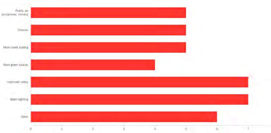
Which of the Following Would Make You Want to Come to High Street More Often?
What Types of Businesses Would Make You Want To Come to High Street More Often?

Much of the development along High Street dates to the late nineteenth century—including Holyoke’s dramatic city hall built in 1870—when the city was experiencing rapid industrial and commercial growth as one of the country’s leading paper producers. Over time, structural economic changes led to disinvestment and relocation of homes, businesses, and activity away from this historic commercial corridor.
Highway 391 was constructed in the late 1960s to connect drivers from Holyoke with the broader Springfield metro area, giving rise to auto body shops and a gas station along South High Street. This history introduces several environmental considerations for future redevelopment efforts: the A&A Gas Station and convenience store at the south end of High Street are active hazardous waste sites. There are also three inactive hazardous waste sites,
located at Aaron’s Furniture Store and two separate auto repair shops (740 and 775 High Street). Perceptions of South High Street in the community suggest different experiences of the neighborhood. In response to an intercept survey conducted during the initial site visit, some participants described the street as “one of the hearts of Holyoke,” “historic,” and “unique,” while others thought of the area as “messy,” “boring,” and “blighted.” Perceptions of safety also varied depending on time of day, with respondents indicating that they felt very safe during the day, and less safe in the evening, which is a common for city streets.
As a centrally located corridor adjacent to Holyoke’s Downtown, South High Street draws on its proximity to a number of community assets, including schools, civic and cultural institutions, and centers for workforce development (see Figure 7). These physical assets are strengthened by the city’s ecosystem of community-based organizations and public entities, which dedicate themselves to fostering a diverse and thriving community in Holyoke.
The public art visible on High Street is one example of community groups’ collaborative impact on the neighborhood. Much of the public art grew out of El Corazón / The Heart of Holyoke art project co-led by Beyond Walls and Nueva Esperanza. Past collaborations between Gateway City Arts, CareerPoint, the City of Holyoke’s Office of Planning and Economic Development, and the Department
Nearby paper mills have also been a historic source of environmental degradation; Parsons Paper Mill (84 Sargeant Street) is currently an EPA superfund site.
As a low-lying city along the Connecticut River, Holyoke is highly susceptible to flooding. On High Street in particular, the high proportion of impervious surfaces can elevate flood risk.

for Public Works have also resulted in unique and lively placemaking projects that contribute to High Street’s cultural significance. As described further in this report, South High Street has immense potential to host thriving business and residential uses, but is currently stymied by lack of foot traffic, low-density, autorelated uses, and vacant or abandoned lots that create large gaps in street activation.
The area around South High Street differs quite dramatically from the rest of the City of Holyoke. Comparing data from the 2020 American Community Survey 5-year estimates for census tract 8116, which includes South High Street, with data for Holyoke overall reveals that the area around South High Street is younger, has lower median incomes, and is more Hispanic than Holyoke in general. Additionally, households in the neighborhood around South High Street tend to
be larger, renter-occupied, and inhabiting older structures. Compared to all households in Holyoke, households in census tract 8116 are about twice
The discourse around designating Main Street as the Puerto Rican Cultural District illustrates ongoing efforts to strengthen Holyoke’s identity and celebrate the city’s Puerto Rican population, which is the largest Puerto Rican community outside of the island itself.
as likely to not have a vehicle available. Together, these demographic differences indicate the unique challenges and needs of existing residents in and around the study area.
Zoning plays a large role in shaping development along South High Street. Holyoke’s last zoning audit was in 2000, and though there have been many revisions since then, reconsidering zoning restrictions in this area could be invaluable for opening up new redevelopment possibilities.

Currently, High Street is primarily covered by two zoning districts: Downtown Business (BC) and Business Highway (BH). In addition, there is the Smart Growth Overlay District, which covers portions of North High Street and other downtown areas. BH districts are widely mapped across the city, but the BC district is predominantly along High Street and on adjacent blocks (one small area of BC zoning also exists in South Holyoke). Both districts generally allow for the same residential and commercial uses; one major difference is that many uses related to motor vehicles (body shops, service stations, garages, etc.) are prohibited in BC districts but allowed by special permit in BH districts. Most of the South High Street study area falls within the Business Highway (BH) district.
In contrast to use requirements, the districts vary widely in their dimensional requirements. Dimensional requirements in the BC district are extremely flexible, which can help incentivize development, as opposed to strict regulations that would add time and additional cost to projects. The
only required dimensional benchmark in the BC district is a minimum site depth of 80 feet, which is the existing depth of all parcels along High Street according to the area’s tax maps. There are no minimum or maximum requirements for parcel area, frontage, yards, building height, number of stories, or lot coverage. Contextually, structures within the BC district typically have ground floor commercial/ retail uses, upper residential or office floors, and are at least 2 and up to 6 stories high.


The BH district has much more stringent dimensional requirements, which limit new development to 2 stories, set specified front, rear, and side yard requirements, and institute large minimum parcel sizes and a low maximum lot coverage ratio. Table 2 compares dimensional requirements of the BH zoning to existing conditions along South High Street, calling attention to how these dimensional requirements are significantly different from what exists currently.
The Smart Growth Zoning District (SGZD) incentivizes the type of mixed-use development present along North High Street but prohibited by current BH district requirements along South High Street. The SGZD was enacted in Holyoke in 2007, following statewide legislation meant to encourage the creation of dense, walkable areas that include transit-oriented development and more affordable housing. This zoning overlay emphasizes residential and mixed-use development, requires that projects with more than 12 residential units be
at least 20% affordable, and lowers required parking minimums for denser development. The SGZD takes advantage of a state Smart Growth Housing Trust Fund to allocate density bonuses to qualifying projects. By incentivizing development, this overlay enables more opportunity within the existing zoning parameters.
Minimum parking requirements are also an impediment to development in the South High Street area, as well as other downtown zones. A 2020 study from WGI found that the median cost of above-ground parking in metro Boston was $25,752 per space, and below-grade parking can cost triple this amount, especially for smaller projects.1 When on-site parking is required, these costs can make development impossible, especially in cities like Holyoke where market rate construction is already difficult to finance. In a census tract where almost half of current households do not own a vehicle and the street grid is already optimized for walking and other alternative forms of transportation,

existing minimum parking requirements are not just cost prohibitive for new development, but wholly unnecessary.
The current zoning code states that for multifamily dwellings, “2 parking spaces for each dwelling unit up to 50 units and 1.5 for each dwelling unit in excess of 50” are required. These on-site requirements can be reduced in downtown zones and transferred to an adjacent or nearby parcel by special permit. However, the process for receiving this special permit, as described in detail in Section 6.1.7, is onerous, and requires submission of a locus plan, utility plan, landscape plan, improvements plan, erosion control plan, stormwater management plan, Development Impact Statement, Traffic Impact Statement, and several other studies and documents. The number and difficulty of these steps, as well as the associated costs and time, are a major barrier to development.

Sign regulations in the Holyoke zoning ordinance are also restrictive. Wayfinding signs currently cannot be higher than 5 ft tall, and the zoning
ordinance only specifies private roadways for wayfinding. Electric signs that change more often than every 24 hours are prohibited. Window signs may only take up 20% of the window. The gross surface area for signs in both the BC and BH zones are 40 sq ft by right and 80 sq ft with a special permit. BH has a building height requirement of 40 ft, but because the BC zone does not have height requirements, the logic of sign restrictions of 40 ft is called into question. In BH for sites of 25,000 sq ft, signs are allowed up to 200 sq ft by right and 300 sq ft with a special permit.
High Street’s existing assets make it well-positioned to be one of Holyoke’s most important and successful commercial corridors. However, the lack of business diversity along South High Street, high cost of rehabilitating buildings, and capacity constraints for local technical assistance providers pose challenges to current and future businesses in the area. Fostering economic development is important for the flourishing of High Street and the
city as a whole. Unemployment in Holyoke—which historically has been higher than in surrounding communities—is currently at 6% in 2022, after peaking at 13% in 2020. In the census tract surrounding South High Street, the employment rate is just 39%.

South High Street is home to at least 48 businesses, from bars and restaurants to auto-related industries. Through the intercept survey, we learned that respondents are most commonly drawn there to access services (such as the laundromat or barbershop), as well as to patronize restaurants. Interest in expanding food and dining options seems to be popular: compared to any other type of businesses, intercept survey respondents indicated that more restaurants and more cafes would attract them to High Street more frequently. Authors of the Wayfinders report actually recommended that the city build on these assets and nurture High Street’s role as an “International Food and Culture Corridor” and a gateway to Holyoke’s downtown. 2
The arrival of the cannabis industry, although prohibited on High Street by zoning, is changing conditions in Holyoke, spurring the rehabilitation of old mill buildings and generating additional revenue for the City through the permitting process.
At the same time, food equity in the city is a recurring concern. Although South High Street has several bodegas and food vendors, there is currently no full-service grocery store in the area, and a prior report on Holyoke’s food system documented residents’ “desire to see a food hub develop in the city” and for “expanded entrepreneurial support for new food businesses.”3
Our research and stakeholder conversations highlighted Holyoke’s rich entrepreneurial spirit. The demand for programs like the business training accelerator at EforAll—whose storefront is on High Street north of Appleton—outpaces capacity.
Eighty-eight participants applied for the most recent cohort, and notably, at least 20 of those applicants were Spanish-speakers. Several stakeholders discussed the prevalence of informal businesses (particularly food businesses) operating out of residents’ homes.
However, the built environment of South High Street can pose challenges to starting and scaling a business. The 2021 Rapid Recovery Plan identified the need for capital for small companies to facilitate both low-lift building improvements as well as larger-scale rehabilitation of abandoned properties to make them suitable for retail and food service.4 However, this is complicated by the fact that most business-owners along High Street rent their space. Through projects like northern High Street’s Artery, city stakeholders are beginning to experiment with more flexible arrangements for enabling entrepreneurs to launch and grow.
The area around South High Street is home to about 10 percent of all households in the city of Holyoke. However, the demographics of the community surrounding South High Street differ from the city overall, indicating a unique set of housing needs for this area (see “Demographics”). Households around the study area tend to be larger than the city’s average and are primarily non-single-family. The Donahue Report indicated that there are not

Key stakeholders in Holyoke’s housing ecosystem include the Holyoke Housing Authority and One Holyoke. Winn Development, though not from Holyoke, is also an active contributor due to its development of new residences near High Street at the old Farr Alpaca Mills Complex. This project indicates the potential for other outside developers to bring their expertise to Holyoke in the coming years.
enough units available for larger families, despite the fact that housing in the relevant census tract is primarily non-single-family.5
Nearly 90 percent of the housing around South High Street is renter-occupied, compared to 60 percent in Holyoke overall. And nearly one-third of renters on High Street are severely cost-burdened, meaning they pay more than half of their income toward housing costs. More than 60 percent of housing in the census tract that includes South High Street was built in 1939 or earlier. This is likely a large factor behind quality issues in existing housing around South High Street, as well as challenges in bringing currently vacant housing up to livable standards.

Two notable efforts by the city to encourage housing development include the Smart Growth Zoning District (SGZD) and the Center City Housing Incentive Program (CCHIP). While the SGZD does not currently include South High Street, the CCHIP does include census tract 8116, as well as three other tracts in and around
downtown Holyoke. The program was established in 2012 (and set to run for 20 years) and utilizes funding from the stateside Massachusetts Housing Development Incentive Program (HDIP). By offering tax abatements on property values that increase due to development, the CCHIP aims to incentivize market-rate residential developments. Unlike the SGZD, this program explicitly focuses on marketrate developments by establishing a floor (rather than ceiling) for median incomes and rents. Cubit Coworks, located across the canals from High Street, took advantage of this program.
Through One Holyoke, the city also offers some financial resources to support owners in bringing buildings up to code: the Neighborhood Improvement Plan provides grants for home improvement of one-to-four unit, owner-occupied properties, while the Rental Neighborhood Improvement Program (RNIP) offers low-interest loans for multi-family property improvements. Not all properties qualify for these loans, however. Priority for RNIP loans is given to properties that are currently occupied and need to be brought up


to sufficient code standards. Owners must also be current on city property taxes and utility payments in order to qualify, and as a federally funded program, the rental units are subject to tenant income limits. In addition to limited amounts of funding, all of the requirements can make utilization and uptake of these loans challenging, especially for smaller property owners. The loans are also unsuitable for renovations leading to market rate apartments.
High Street is a one-way street with two driving lanes, two parking lanes, and relatively wide sidewalks (depending on the part of the street). Past research has suggested modifications to this layout, particularly through the introduction of “bike lanes, safe pedestrian crossings, traffic calming elements, and accessible transit systems,” to adopt a Complete Streets approach to mobility.6 Similarly, Holyoke’s master plan includes a plan to fix up the city’s gateways—roads and streets like I-91 and 391, and especially Route 202—that lead from neighboring communities into the city. This could include building redevelopment or demolition,

While Holyoke doesn’t have many bike lanes, there is support for bikes. Holyoke’s Biking & Pedestrian Committee meets monthly. Valley Bikeshare provides bikeshare throughout the region, from East Longmeadow to Sunderland. Roughly 14 stations are in the Holyoke area, mostly concentrated downtown. None are on High St, but a few are on nearby Maple St.
20-33 percent of Holyoke’s children have pediatric asthma (compared to 10.6 percent nationally). There is a strong association between high traffic arterial roads and asthma. These problems could be eased by encouraging active transportation, as well as by allowing for more trees and other greenery to clean the air.
Regional transit is comprehensive, with buses connecting Holyoke to Springfield, Amherst, Northampton, and other nearby towns. An Amtrak station opened in 2015 with two routes that stop at Holyoke: the Valley Flyer runs between Greenfield and New Haven, and the Vermonter runs from Vermont to Washington.
vacant lot improvements, signage, tree and landscape plantings, street furniture, and lighting. Active transportation on High Street is currently limited. 89 percent of Holyoke Bike Survey respondents said they would like to bike more often but are worried about safety.7 As a small city with mostly quiet streets, the introduction of a few strategic bike lanes on busier roads like High Street could go a long way toward making biking safer citywide.
In terms of public transit, High Street is particularly well-served, as buses operated by the Pioneer Valley Transit Authority go down both High Street and nearby parallel Maple Street. Routes also connect High Street to the east side of the city and the other side of the canals. High Street is particularly well-served by bus stops.
Supported by our overall vision for a vibrant South High Street that provides diverse economic opportunities, strengthens community ties, and contributes to the long-term flourishing of Holyoke’s residents and our analysis of existing conditions, we have identified three major recommendations that support these goals:

These recommendations individually and collectively address the visions and aspirations set forth in our plan.
The following sections will provide detailed descriptions of each recommendation. Then, specific strategies to scale will be discussed.
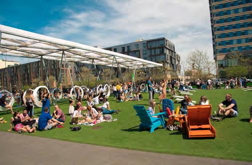
In pursuit of a vibrant and welcoming High Street, we would be remiss not to recognize the importance of an invigorated public realm. Especially with High Street serving as an important entrance point to the city coming off I-391, a person’s first impression can be heavily dictated by their perception of the public realm: does the streetscape make them feel safe and welcome; what sense of the culture can somebody get of a place just by driving by? The public realm of a place has the potential to encourage different communities to interact and gather, to connect hotspots across blocks on a street, and to acquaint those new to a city. To revitalize South High Street, we find it crucial to activate the public realm to spark community engagement and use of the street.
In identifying this goal, we spoke with a number of passersby on High Street. Although responses varied, there were a number of people who commented on High Street feeling deserted and somewhat unsafe. Currently, the way that residents traverse High Street is isolating. People get in their cars, stop where they need to go, and then get back into their cars. This way of transport is often destination-based, with cars as a primary vehicle of transportation. In our field observations, it appeared that even when somebody had multiple destinations along High Street, they tended to get back in their cars to travel to their destinations, even if the next one was only a couple of streets down. There is a missed opportunity in this way of traversing High Street when it comes to social and economic
activity. Activating the public realm for community use can enhance public safety and community connectivity.
Underlying much of the way we thought about activating the public realm on High Street was establishing the connection between nodes and street life along the South High Street. How do we keep people moving along the street and engaging with the street between destinations? How could the public realm encourage that exploration? Our ideas constantly come back to this framework.
Ultimately, we arrived at four main ways to enhance the public realm along South High Street with this framing of connectivity in mind. These include: reforming the street and increasing mobility; revitalizing street life to increase connectivity; reprogramming vacant land; and building in biophilia, green infrastructure, and resilience.
A fundamental factor in how streets are traversed starts with how they are structured and set up. To increase mobility of all people, the streetscape must invite and encourage use of alternative modes of transportation including bicycles, transit, and pedestrians. Use of alternative modes of transportation also encourages greater engagement with street life and conversations with other passerbys and store owners, as it is much easier to stop and engage with something on a bicycle, at a
bus stop, or on foot. Furthermore, the development mechanisms for alternative transportation methods can increase mobility and encourage more meaningful engagement with street life.
High Street currently has exceptionally wide travel lanes of 14.4 ft, which is greater than the standard of 10-12 ft for most travel lanes (see Figure 17). Narrowing each travel lane to 11 ft still enables even large trucks to pass through, while creating new space for the addition of a bike lane. In this way, the addition of a bike lane adds diversity of mobility modes to the street but does not affect the overall capacity of the road for parking and traveling.
Narrowing travel lanes has also been shown to increase pedestrian safety, as cars must drive slower and more cautiously. However, the speed limit of

the road does not need to change. Many design standards cite the speed limit of a typical travel lane and major collector street of 10-12 ft to have a design speed of 30 MPH and posted speed of 35 MPH.
A safe and engaging streetscape includes mechanisms to invite lengthy stays and improve connectivity, which increases economic activity and overall vibrancy of the street. Revitalizing street life along High Street for these purposes requires the addition of more activities to increase the diversity and livability of the street.


Improving street lights will not only make South High Street safer for residents and visitors but will also increase local nighttime economic activity for bars, clubs, and restaurants on High Street. This would revitalize the local economy along the street. The street lights that currently exist on North High Street should be extended along the entirety of High Street for cohesion and consistency in aesthetics.

Street furniture is a great way to activate spaces quickly. They make the outdoor realm much more useful, inviting people to stay rather than just pass through. They also improve the look and feel of the street. Pieces of furniture are inviting to pedestrians and they are an interesting visual addition to the street. They can incorporate engaging forms of artistic and architectural expression with unique structures and colors. They also improve comfort and safety, bring people to local businesses, and can make nearby housing more desirable. Street furniture includes things like benches, tables, parklets, and transit shelters. High Street has

exceptionally wide sidewalks, of over 10 ft, which means there is ample space for street furniture along the sidewalks without changing the curbs.


Additionally, with or without the addition of a bike lane, more bike racks should be installed along High Street to encourage the use of bikes as a form of mobility and offer another form of transportation for people to access High Street. Bike racks also can be thought of more creatively, doubling as both racks for bike storage as well as a form of art and expression of community identity and pride.
One primary way to support the growth of small businesses in a more accessible way is by formalizing informal vending. Street vending requires less fixed costs and upfront physical infrastructure than a
storefront or a food truck. The barrier of entry to start up small businesses can often deter local residents. Community organizations like Nuestras Raices, for example, have recognized physical infrastructure as a barrier of entry for locals and in response, they have started renting out their kitchen space for aspiring caterers through their Food Hub Initiative.

We believe there is a unique opportunity for street vending to stimulate Holyoke’s local economy and enliven the public realm, and the City can play a key role in this initiative.
For revitalizing street life, street vendors can be uniquely placed to connect popular destination points along the street, lined in front of parts of South High Street that may currently be “dead space” to encourage visitors to keep walking along
the road rather than get back into their cars and leave. Strategically placed street vendors can connect nodes along South High Street and bring a vibrancy, as well as produce safety, by bring people back to High Street throughout all times of the day.


Wayfinding methods allow people to find their way around town. This can take the form of signage on the street or on storefronts, storefront indicators,

murals, etc. They give people ideas about new places to visit, and create cohesion. Street signage, for example, points to places that are within walking distance, which encourages walking in town, and brings more people onto the street and into local businesses. Investment in wayfinding makes the city more fun for locals and easier to navigate for people coming from out of town. Downtown Holyoke has an existing dense walkable grid, which is an asset in encouraging wayfinding methods and walking in between nodes.
Art installations in the public realm are a way to encourage interaction with the urban space. A powerful tool for placemaking, art installations can utilize a broad variety of art forms, depending on the unique character of the city and local values and preferences. In Holyoke, some of the unique community characters and identities that could be incorporated and played on are the “birthplace of volleyball” title; the renewable energy history; the history of being a vibrant mill city; and the strong Puerto Rican presence in the city. If Holyoke’s unique identities are strategically leveraged, the City can really set itself apart from others in Western Massachusetts and attract foot traffic.
Installation art can be used to highlight public spaces. There is potential for art installations to be interactive physically, audibly, and visually. The interactive nature of public art can be leveraged


as a tool in building community character and sparking engagement and use. Specifically, audio art is a valuable way to enhance cultural, social, and political communication. Sound can change the way a community views and interacts with a space.
Art installations can also be used as a tool to uplift local artists and businesses. There is a strong arts culture on High Street, including the opening of the Artery, and the El Corazón / The Heart of Holyoke network of wall murals throughout downtown Holyoke. The addition of art installations is a way to connect to existing art infrastructures and local artists. Overall, art installations are a fantastic way to showcase local art and cultivate a sense of identity in a public realm. The addition of art installations would elevate South High Street into a street that is more tangible, engaging, and community-oriented.


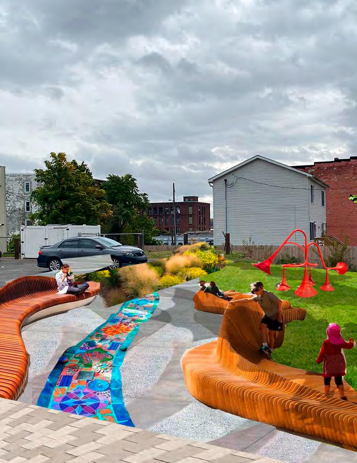
In alignment with this idea of connecting nodes and street life, we identified areas of empty activity and “dead space.” There are a number of vacant lots along South High Street that can be repurposed and reprogrammed. As can be seen from Figure 36, the parcels with empty lots span across High Street, creating many areas of disconnect. To encourage people to traverse down High Street, these lots need to be reimagined to invite people down the street. At the same time, a key component of renovated or beautified space is ensuring that it gets used. Programming an area consistently is critical in engaging the community in the long term. There are a number of community organizations such as Nuestras Raices, the Boys and Girls Club, the Holyoke Library, and others nearby that can

help in programming the space. Below, a number of different ideas in which space can be programmed are described, as well as examples from other cities in which it has happened. We also note potential opportunities to partner with existing organizations for the purpose of sustainable maintenance and implementation of programming.
Primarily, vacant lots can be transformed into be plazas or parks for programming. Programming presents opportunities to bring the local community together, and bring outside communities and added foot traffic to High Street. Being in New England, Holyoke does have to account for the different seasons, although the seasonality presents complementary opportunities. In warmer months, parks or plazas can be programmed with farmers’
markets, classes, outdoor movie nights, and performances. In colder months, parks or plazas can be programmed for winter activities and themed for the holidays. Infrastructure-wise, the lots can be transformed in ways that allow for multiple programming uses. For example, building a stage platform allows for performances and classes to happen easily. In many cities, similar programming exists already, including outdoor yoga led by local yoga studios; open mic or comedy shows; dance classes with local dance studios like Star Dancers’ Unity or Theater Dance Studio; and workout classes ranging from Zumba to cardio fitness. There are also a number of opportunities for performances and shows such as outdoor movie nights, dance shows, and concerts, all of which can be coordinated with local organizations and businesses. For example, the Holyoke Public Library already plans performances and movie nights in their community room. Partnering to organize a performance or movie night in a nearby park or plaza could be very effective. Partnerships are beneficial to the local organization or business in terms of increasing visibility and engagement, and beneficial to the

Outside of programming, there is a lot of opportunity for activating local businesses on vacant lots that are transformed as plazas or pedestrian spaces. Street vendors, a previous recommendation, can be formalized and encouraged to sell in the plaza or park. From setting up art markets to lunchtime food carts to mixed vending, Holyoke can support residents that want to pilot small businesses without such a high barrier to entry. Many cities across the world already use this method to liven up their downtown plazas.


Another way to both revitalize vacant land as well as to bring more healthy fresh produce to High Street is to turn all or part of an existing vacant lot into a community garden. During our conversation with Nuestras Raices, they shared that they likely have the capacity to run another garden, especially as ownership of their current gardens is sometimes in flux as a couple of their gardens are on privately owned land. Nuestras Raices could be a critical partner to maintain a community garden. The garden could also involve youth programming or a youth garden section to bring a more steady flow of users. This would also serve as an educational tool about sustainability and food justice, and presents opportunities to partner with establishments in neighboring blocks such as the Boys and Girls Club or Head Start. Especially on High Street, where fresh produce can be difficult to find, the creation of a new community garden would allow for multiple goals of health, sustainability, and vibrant community activity to be actualized. Currently, Nuestras Raices is operating on a number of lots, ranging in size from 1,500 sq ft to 3,500 sq ft, to as large as 11,400 sq ft. This range of dimensions implies that the vacant lots
along High Street can realistically host a community garden, either on the entire lot or on part of a lot. Figure 45 is a rendering of what the parking lot next to the Congregation Sons of Zion could look like with half of it devoted to a community garden and half of it to a plaza populated with street vendors.
A further way to use vacant lots in a way that enhances local business activity is through specialized markets such as the existing Holyoke Farmers’ Market, flea markets, or holiday markets. The Farmer’s Market already happens weekly in the summer in Downtown Holyoke. Bringing the market to South High Street on one of the currently vacant lots or holding an additional farmers’ market on a different day of the week on the same lot could bring more foot traffic to the area and activate South High Street in a way that promotes fresh and whole food options in the area, especially given the success the existing market is already seeing. During winter months, holiday markets or vending specific to the holidays, such as Christmas trees, prove quite successful in a number of cities and serve as effective uses of previously vacant lots.


Outside of holiday vending and markets, a vacant lot during winter months can be used as an ice rink or as public space to linger and gather in between errands or activities. The COVID-19 pandemic has opened a number of creative ways to encourage outdoor gathering and engagement even in the cold. From temporary heated igloo lounges that shield from the cold, to outdoor heaters or fire pits, private businesses have innovated a number of ways to encourage outdoor dining and gathering that cities can employ for people to be able to enjoy the outdoors publicly and comfortably.


Resilient cities can quickly adapt to changing conditions and recover from shocks, disasters, and the impacts of climate change. Green infrastructure protects communities from the impacts of flooding and stormwater pollution and also plays a role in climate change mitigation and beautifying space naturally. Traditional gray infrastructure (gutters, pipes, and tunnels) have a variety of challenges including degradation with age, and a lack of capacity for large quantities of stormwater. Green infrastructure can be incorporated in the public realm through landscape and streetscape design to enhance water infiltration and absorption, as well as carbon sequestration. Green infrastructure can include the addition of vegetation and soils in the
form of water catchment basins and bioswales, and has the capacity to regulate the microclimate as well as improve air quality and habitat. Additionally, green infrastructure can be used as a tool to enhance community ownership over a public space by the encouragement of interaction and maintenance of a space over time. Investing in green infrastructure means investing in a healthier and happier lifestyle for visitors and residents.
Bioswales are useful for stormwater and urban runoff. Stormwater management standards have regulations for design and performance, including requirements for bioswales per impervious surface area in a city. Bioswales consist of vegetation,

rocks, and soil to filter and absorb stormwater and urban runoff. Bioswales are typically placed along roads and parking lots and can add natural beauty to an urban area largely dominated by impervious surfaces.

Street trees are a critical way to increase green infrastructure on South High Street. Street trees capture carbon dioxide and provide shade and cooling to an urban environment. They also improve air quality and make streets more inviting which can increase property values and beautify urban landscapes. The Holyoke Urban Forest Equity Plan reports that downtown Holyoke currently has 72% impervious surfaces and only 16% land covered by
tree canopy. In the four downtown neighborhoods of Holyoke, 20% of all street trees are in poor or dead condition. In accordance with the Community Based Assessment of Urban Forestry Conditions in 2014, which established a goal of 30% tree canopy cover in Holyoke’s Environmental Justice areas by 2044, replanting empty street trees pits downtown would be a significant addition. A community with excellent maintenance of street trees is Somerville, MA. The Urban Forestry Division in the City of Somerville manages and cares for the street tree program. They make maps each year showing details about the placement and species of each tree planted.
Along with street trees, tree pits are a way to retain and infiltrate stormwater while enhancing ecosystem services of the urban streetscape. Biophilic urbanism or the use of natural elements in streetscapes, is both a useful design and sustainability tool. Tree pits can be decorated with permeable metal grates or other public art forms, or can have vegetation to maximize ecosystem services and water infiltration. In this way, tree pits can act as bioswales of their own. Trees pits can be used for things like ornamental gardens, vegetable gardens, and artistic expression.


Oscar grew up in Holyoke. He loved it. And he had done well in school, too. He had gone to Northeastern on a free ride where he played basketball and studied business, and had spent the last couple years in Boston working for a pharmaceutical company after graduating. But he never forgot Holyoke, or his friends there.
For his 28th birthday he knew a vehicle was a smart investment, and he had bought a Rivian and drove back to Holyoke to catch up with the neighborhood. It’d been a few months since he’d last been, but he liked the development that he saw. The green features like what he saw in Cambridge made him smile knowing the city was keeping resilient. The cannabis shops always made the trip worth it, too. But the food was what he dug the most. Mofungo, Pollo Guisado, Empanadillas, all of it, and High Street had the best comfort food.
He pulled off 391 and was delighted to see solar charging. Without missing a beat he backed his truck into a charging station. New paint reflecting bright in the sun, white-wall tires still clean, pinstripes popping, Oscar put on his sunglasses and exhaled with a smile.
“Hey, look at this tourist!” his friend Ricardo was skateboarding by and he stopped and shouted before coming in for a high-five and a hug, “long time, nice camion!”
“Too long, it’s good to be back. You like? I took the plunge and went electric.”
“You know the shops on the street will want a look at it, I’ve been telling them they need to cater to more electric cars but they don’t listen, man!”
“They’ll come around. Let’s get some food, I’m starving!”
The street was different from the last time Oscar had been in town, slow changes that showed the place was getting with the times. It felt hip, but not gentrified, still Holyoke, by Holyoke. The two walked up High Street, past a bespoke parklet by the laundromat, the smell of herb and the sound of laughter carried through the air. Oscar craned his neck to look around the painted walls, curious.
They kept going, past the old Haberman block, now under construction.
“What is this? It’s huge!”
“Yea it’s supposed to be 6 stories - my sister plans to move in, it’ll be awesome when it’s finished! You really gotta see the rest of the street, O!”
New trees lined the sidewalk, with raised beds and seating by a new restaurant.
“Hey look what the cat dragged in!” Someone shouted from a cushioned enclave, behind a plate of hot food. “Good to see you, Oscar, take a seat!” Oscar’s mouth watered. Nothing compared to the food on High Street, nothing compared to home.
Our recommendation is focused on the city block between the intersections of Essex and Cabot Street. Though located in the middle of Holyoke’s growing downtown, the southern part of High Street has its own particular and complex challenges and assets. While North High Street boasts City Hall and a growing number of restaurants and business initiatives, such as the new Artery store, South High Street has had its own struggles. Walking from North to South High Street, there is a recognizable difference in the level of investment. While the potential of North High Street is evident walking down the corridor, South High Street seems to be lagging behind.
Vacancy is the most visible challenge of South High Street. Much of the retail space along the street sits vacant, in addition to many empty lots and uninhabited upper floors. Due to the industrial downturn and exportation of industry, Holyoke saw a loss of jobs and eventually residents. A byproduct of these changes was a lack of oversight and maintenance of many buildings in downtown Holyoke due to a decrease in the spending capital of customers, resulting in declining businesses. Many of these buildings were abandoned, causing many of the vacant lots now present on South High Street. The block between Cabot and Essex is currently made up of the vacant Haberman Hardware building, the uninhabited HapCo Auto Parts Store building, and an empty lot (see Figure 57 for details). The Haberman buildings are owned by the Haberman trust but they have been uninhabited for
years, most likely due to back taxes. Many buildings in Holyoke suffer from this same problem which serves as a roadblock towards new ownership and revitalization.
Today, the existing businesses on South High Street near the Haberman block are dominated by car repair shops and convenience stores. Across from the Haberman building sits Sam’s Convenience Store. Though Sam’s large parking lot is underutilized and viewed by some as an attractor of crime, these convenience stores are stocked with a variety of goods and sometimes even contain fresh fruit. They are essential in food deserts like South High Street, but only serve as a band-aid to the larger problem of the lack of affordable fresh food. The other dominant business type is car repair shops, which have large footprints compared to the amount of foot traffic they bring to High Street. There is very little on South High Street that brings people and keeps them there, which creates a vicious cycle of low foot traffic that prevents investment.
These abandoned buildings on South High Street serve as static symbols in a changing world, sitting vacant as decades of zoning changes and building codes have evolved past the standards of the late 1800s. Now these buildings are not only outdated but may require millions of dollars to bring them up to livable standards, including replacing windows, piping, floors, insulation, and balconies. Even more money will be required to ensure ADA compliance and standards of sustainability. For larger, higher income cities like Boston that suffer a similar
problem, the expense of making buildings code compliant is a profitable venture, as landlords can expect to make money back on their investment in a short period. However, around South High Street, where a majority of residents are low-income, the overhead costs to repair these buildings and the market-rate rents that can be demanded creates a gap between opportunity and need.
In spite of these challenges, there are many assets that make this block a vital area for redevelopment. Despite the low foot traffic on South High Street, the area benefits from a high residential population due to surrounding housing complexes and historic brownstones one block over on Maple Street.

Therefore, South High Street has potential for foot traffic and access to a customer base within a few blocks, if the street can be repopulated with businesses and programming that keep the surrounding residents on the street. Furthermore, South High Street has vital and important institutions such as the Holyoke Public Library, the Boys and Girls Club, and a growing number of cannabis dispensaries that bring in business from across New England, creating potential for a growing customer base.
Perhaps the greatest asset of South High Street pertains to the greater Holyoke area, as there is a high demand for housing in Holyoke. Similar to the
rest of Massachusetts, there is a housing shortage in the city, and Holyoke serves as one of the most affordable areas in the increasingly expensive Pioneer Valley. Therefore, it serves as a desirable location for people in the area and new immigrants looking for an affordable place to reside. However, with the rising cost of living in larger cities such as Northampton and Springfield, Holyoke has the potential to welcome more residents who are not formally low-income but also don’t earn enough to afford to rent or buy in these more expensive markets. As of now, there is a housing gap for this population. South High Street not only has revitalization potential because of the need for housing, but also its location provides many assets that can support revitalization and the inclusion of other essential businesses and services.
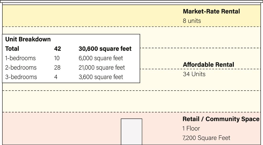
South High Street could benefit from a large-scale redevelopment project that would help catalyze future investment and activity in the area. The 13,400 square foot lot at 510 High Street is a prime opportunity for a six-story, mixed-use development that will supply needed housing at a range of pricepoints and help enliven the area’s streetscape. Six stories would make the project feasible for the cost and keep it within one floor of structures on surrounding blocks and therefore well-suited for the street. Building at this scale is possible under the current Downtown Business (BC) zoning on the Haberman block, making it a prime candidate for an initial redevelopment project. Building to this scale on the rest of South High Street could be better facilitated through changes to the Business

Highway (BH) zoning in other portions of the corridor, as discussed later in this report.
In this example project, the five upper stories would be devoted to rental housing predominantly sized for families and larger households, to meet the needs of the surrounding community. The inclusion of both market- and non-market rate units is intended to address expressed concerns for both maintaining and expanding Holyoke’s affordability while also creating avenues for families to remain in the neighborhood as their earnings increase.
We included five parking spaces along the backside of the building for residents or visitors who need immediate building access. Otherwise, people who need parking can take advantage of the city-owned lot directly across the street, which has space
for at least 50 vehicles as currently marked. High Street also has ample street parking, with 16 spaces currently designated on this block alone (and untapped opportunities for more efficient parking, as described previously in this report). Given the high cost of construction and tight margins for development in this area, requiring parking on-site could easily make a project like this unfeasible. The city simply can’t afford to sacrifice valuable square footage and dollars in a project like this to parking space.
Although this proposal is all rental units, a similar project could include for-sale units, particularly on the upper floor which is dedicated to marketrate housing. While some sources of funding, such as the Low Income Housing Tax Credit (LIHTC), are only available for rental housing, Holyoke is

eligible for MassHousing’s CommonWealth Builder program, which provides up to $250,000 of funding per income-restricted for-sale unit (70-100% AMI) to cover development costs. The program covers both new construction and adaptive reuse projects, and the for-sale units built become restricted for income-eligible first-time homebuyers. Flexible or subsidized financing for market-rate condominiums is more limited, as this type of housing is by definition not income restricted and would not be eligible for most state or federal housing subsidies. However, recognizing the challenges of developing market rate housing faced by Gateway Cities, Massachusetts’ Housing Development Incentive Program (HDIP) is one option that provides subsidies in the form of tax incentives to develop market-rate properties for lease or sale. This program has been successfully used in Holyoke already in the development of the Cubit building. A successful development on this block could bring the foot traffic and activity needed to reduce the risk for similar large-scale redevelopment of the former Hapco Auto Parts and Haberman Hardware Store sites next door.
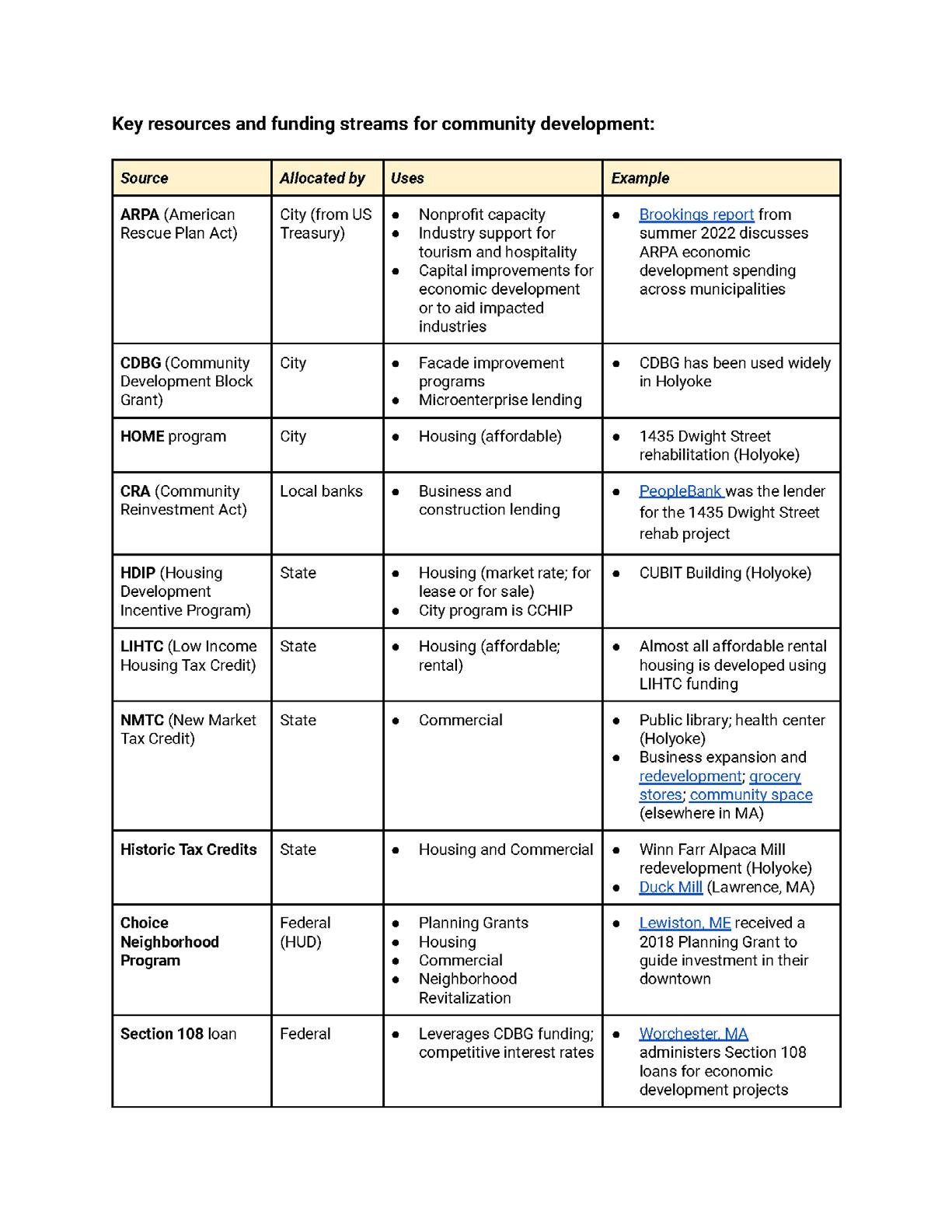
In 2021, a new 48-unit affordable housing development opened in the Gateway City of Brockton, MA. The project was constructed on a formerly vacant lot and includes a beer hall on the first floor. NeighborWorks Housing Solutions served as the developer, and secured financing from MassHousing—including $1.8 million from MassHousing’s Workforce Housing Initiative—as well as $1 million from the Affordable Housing Trust Fund. Other funding sources included federal and state LIHTC equity, local HOME funding, support from the Department of Housing and Community Development, and $750,000 from the Community Economic Development Assistance Corporation.
Created in 1986, the Low Income Housing Tax Credit program is currently the largest federal program for income-restricted rental housing development. Investors in affordable housing projects purchase tax credits that offset their own tax liability, and the funding generated by the tax credit sale is used as equity in the development or rehabilitation of housing. The Department of Housing and Community Development (DHCD) is the allocating agency for tax credits in Massachusetts, and projects must apply to the agency to be awarded credits through a competitive process under the state’s Qualified Allocation Plan (QAP). LIHTC is a useful way to bridge budget gaps in housing development, especially in areas where pooling enough investor equity to finance construction is difficult. However, since the allocation process is competitive, most successful LIHTC projects are 100% affordable housing and/or large in scale.
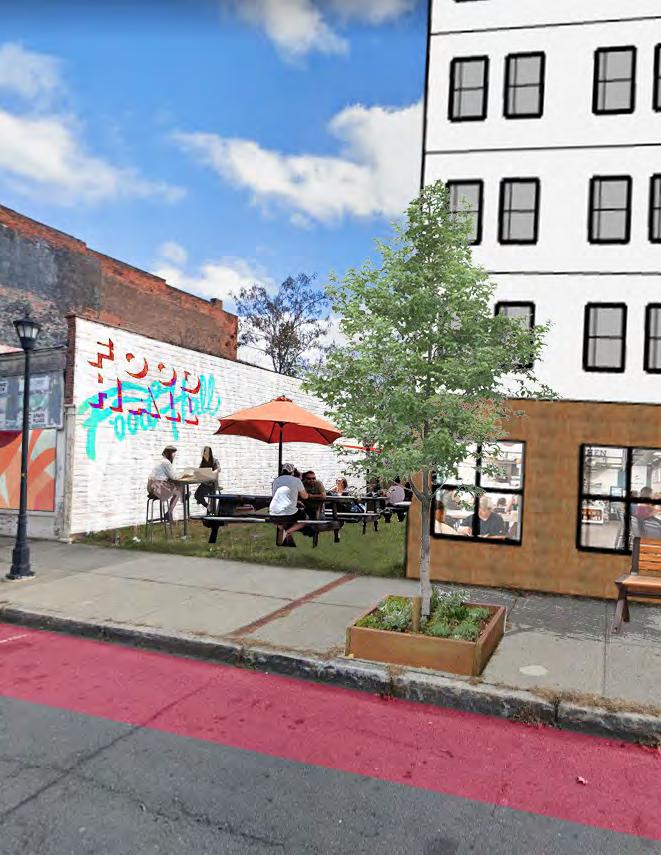
Syracuse’s Salt City Market opened during the pandemic, but the idea for a community food hall was generated much earlier by community organizers. The project was funded in part through the support of a local family foundation, and was envisioned as an incubator space for local residents to build intergenerational wealth through successful entrepreneurship. The market celebrates “regional and international cuisine from entrepreneurs in your neighborhood” and is currently home to 10 vendors and frequent community events. Salt City Market’s vendors also benefit from Syracuse’s Double Up Food Bucks program, which matches federal SNAP dollars $1-to-$1 for customers purchasing fresh fruits and vegetables. Finally, Salt City Market occupies the first floor of a 26-unit apartment building, which includes some affordable units.
On the ground floor, a vibrant food hall would build on High Street’s existing international food and restaurant culture. Our research and interviews highlighted a desire for greater access to fresh food in the South High Street neighborhood, as well as flexible opportunities for entrepreneurs to start and scale. The proposed food hall would provide both, allowing vendors to sell wholesale fruits and vegetables and other food products currently missing in nearby corner and grocery stores. Other stalls would be devoted to prepared foods, and provide a lower-risk option for entrepreneurs looking to experiment and gradually scale their informal businesses or new ventures.
For Holyoke vendors, being part of a food hall reduces risk by creating a bigger draw for residents and visitors, reduces start up and marketing costs, and allows for shorter and more flexible leases. Existing non-profits like EforAll are already providing diverse support to Holyoke’s entrepreneurs, and could be a partner in identifying businesses suited for the opportunity. The food hall would be another piece in Holyoke’s broader entrepreneurial ecosystem, filling the gap between mobile kitchens like food trucks and more costly, long-term commercial leases. It would also supply flexible, indoor community space for Holyoke at large. A public patio would allow activity to spill out onto the street, meeting the need for public gathering space along this stretch of High Street. Enhancing the social life of High Street and bringing much-needed foot traffic is a key goal of this development proposal.
We estimated total development costs for this project to be approximately $10,000,000, which would rely on about $3 million in LIHTC credits based on the proportion of affordable units in the building. The building could generate almost $400,000 annually in apartment rents, with the potential for additional income from the food hall’s standard operations and capacity to be rented out for special events. To meet the gap in development equity, Holyoke could draw on a number of city and state funding sources such as the state Affordable Housing Trust Fund or TDI Equity Investments, and CDBG or HOME funds. Ultimately, we think channeling resources into a major project like this would be a demonstration to investors that such redevelopment is possible, while actively
contributing to the foot traffic that would make those investments less risky for private developers.
Bringing investment to South High Street will create much-needed improvements and upgrades in existing buildings, provide opportunities for businesses to develop and expand, and increase property values over time. However, as investment builds and land prices begin to rise, existing residents of South High Street may be at risk of displacement.

Community-ownership models present a way to address these concerns while also spurring the types of growth that will create a vibrant, safe, and beautiful South High Street. These models include:
• Community Land Trusts (CLTS) – Residential and/or Commercial
• Cooperatives
• Credit Unions
• Real Estate Investment Cooperatives
• Community Investment Trusts
Community-ownership development can include models that increase occupant equity, removing properties from the speculative market and transferring them to a community-based nonprofit or a shared-owner equity model. They can also rely on neighborhood crowdfunding, allowing community members to purchase a share in an income-producing property.
These models can also be combined. A study from LISC on community-ownership models for commercial spaces found that it was important to raise capital for a non-profit to acquire and begin to redevelop properties even in advance of a clear vision for the space, so as not to miss the window for acquisition before area land prices rise.8 Community engagement and co-design around shaping the future of the space can happen concurrently, and non-profits can work to eventually transfer the property to community ownership once the model is structured. The report also found that
it was important for groups to develop partnerships with organizations that have experience in commercial development. Some lenders, such as LEAF, a Boston-based Community Development Financial Institution (CDFI), provide low-cost financing specifically for commercial cooperatives.
Holyoke, and South High Street more specifically, is a perfect place to implement a community ownership model for commercial development. Many small business owners want flexibility in their spaces and can’t afford to take on the risk of being the sole owner/lessee of a brick-and-mortar storefront. Pooling equity allows for businesses to share risk while also building wealth and stability together. As investment in the area begins to drive higher land prices, a community-ownership model can help existing businesses and residents stay in the neighborhood and share in the benefits of a vibrant South High Street. Since land prices are currently low, strategically identifying one or two sites as candidates for community ownership early is critical.
Gloria had seen the development the city had made in the last decade, and it brought her comfort. She knew the city before the changes, and she preferred the tree-lined streets and open air arcades to the parking lots and abandoned structures. She saw the solar and its shade where before there was devoid, hot, concrete. She saw the affordable housing where before there was blight. She saw the full storefronts where there was once condemnation and broken glass. She saw growth.
She lived in one of the new city blocks, one of those beautiful 6 story apartments with the gardens on top. The city worked hard to support the success of the first one, where she rented with her husband. The model was quickly popular and a few private developers built similar buildings throughout town. But they loved their block. Her daughter Imi went to Pre K around the side with her neighbors. Her husband helped manage the bakery up the street. He took classes with a local non-profit and started in their home. Now the smell of their goods would waft down the streets and Imi loved eating her father’s baked goods at the end of the day.
Gloria smiled. Things were nice.
She delivered baked goods and other parcels on her Ebike between Holyoke, Chicopee, and Springfield. It wasn’t easy or glamorous, but she could do it while taking classes at night, and maybe use her brother’s car in the cold months. The margins were good, and she saw their bank account growing slowly.
Every morning she swapped her universal battery for a fresh one at the Sun Station, part of a program the state set up for Ebike users for a small fee. She liked that it kept her going, moving up and down the valley. Sometimes she’d bring a delivery as far as Amherst, and soak in the ride back along the river, past the farms, over the dam and back into town.
Today she was just happy to be moving; to have the sun on her shoulders as she rode, to know her daughter was smiling back at her play group. It was better than she had had it growing up, and it was something to be thankful for.
Holyoke has always been ahead of the curve in terms of sustainable energy independence. In this regard, the Holyoke SunStation and the Great Green Arch are meant to complement one another, both providing shade and utilizing the sun for energy and growth. They beckon travelers into the city from the highway and introduce them immediately to Holyoke as a city that has always relied on its own means for energy independence, from the river to the sun. The two fixtures serve as the key to addressing climate resiliency, complementing Holyoke’s energy infrastructure.
Today, through proper grant management and implementation, the funding (such as, National EV Infrastructure Program or Mass EV Incentive Program) can be found to make this project a reality that benefits the entire community.
The SunStation and Great Green Arch will attract outsiders to High Street for short periods, presumably up to two hours as they charge and stretch from their drive, return to their cars and leave, ultimately providing short stay foot traffic for local businesses, while also providing a sense of security for those who leave their vehicles to charge. In developing this site, the City is also proactively preparing parking and charging infrastructure for a future where High Street will more naturally attract visitors, balancing future demand with an existing supply of parking and services. Furthermore, it can benefit residents who need EV charging now.
Ultimately, the SunStation will allow the city to diversify energy sources, and deepen their energy capacity to be used at their discretion. The public/ private framework of development should allow the City to scale this model, working with property owners to add future solar capacity given an agreed partnership. The goal then is to get property owners with large impervious lots and/or roof space to partner with the city, creating a tapestry of grid systems that benefit property owners, the city, and residents. There is also potential for revenue generation and/or energy credits that can be used for consumers.
With the SunStation and the Great Green Arch, Holyoke announces to Massachusetts and the country that it is capable of planning and managing a 21st-century sustainable energy system, relying on public and private partners to develop resilient infrastructure and energy security.
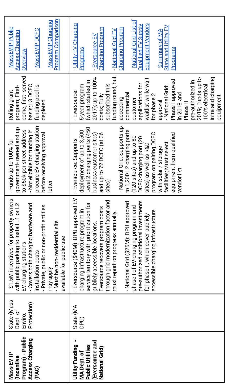
The City of Holyoke has only recently begun to make some nominal investments into electric vehicle charging. According to the U.S. Department of Energy’s Alternative Fuels Data Center database, there are ten electric vehicle charging stations in Holyoke. Three of the stations are downtown: a twoport station at the Holyoke Public Library, a twoport station at Veterans Park on Chestnut Street, and a two-port station at the Holyoke Train Station.9 These stations were installed earlier in 2022 by
Holyoke Gas and Electric after receiving a $64,000 grant under the Massachusetts Electric Vehicle Incentive Program.10
Although there are several existing charging stations right off of I-391 and I-91 in Holyoke, each can only service a maximum of 1 or 2 vehicles at a time. Between Northampton and Springfield, there are no existing charging station “pods,” where more than 2 vehicles could charge simultaneously. Charging station pods are likely to attract more drivers given that there is a higher likelihood that at least one charging station port will be available for immediate use. Especially as gasoline-fueled car sales are to end by 2035 in the state, the demand for charging stations and other green infrastructure is expected to increase substantially over time.11
Charging stations have been installed to date only as ancillary uses. The 2022 Zoning Ordinance does not include electric vehicle charging in its Table of Principal Uses.
According to Holyoke Gas & Electric, seventeen utility scale solar projects have been developed and commissioned in Holyoke, totaling 17.82 MW of installed capacity.12 On average, the total output from these existing facilities can serve approximately 17% of homes in the city. The largest solar facility


site in Holyoke, Mount Tom Solar, is amongst the largest in the entire state. Formerly a coal plant, the site was converted in 2018 following a just transition campaign led by local residents, businesses, and labor unions.13 Smaller solar facilities have also been installed at the Greater Holyoke YMCA and the Holyoke Boys & Girls Club, amongst other sites.

Since 2011, the Holyoke Zoning Ordinance has included solar photovoltaic facilities in its Table of Principal Uses. Solar facilities are currently permitted in the Downtown Business, Entryway Business, and Highway (vehicle-oriented) Business Districts, amongst others.
Design and environmental standards are outlined for large scale ground mounted, small scale ground mounted, and roof mounted facilities. Of note, the current screening requirements mandate that vegetation, fencing, or other screening tools be “maintained above the highest level of solar panels” or “as otherwise determined to be adequate”, per the ordinance.

While there are a number of parcels within the Study Area that could be suitable candidates for investment, we will focus on Lots 9 and 10 as a case study.
Lot 9 is located on the corner of High Street and Resnic Boulevard at address 820 High Street. The parcel is 0.37 acres and was last sold for $700,000 in March of 2021. The parcel was sold to OM Holyoke Real Estate LLC by A & A Shell Inc. The lot is currently used as a service station, which is still operated by A & A Shell Inc. The lot is considered
an active hazardous waste site. That said, there are no reported releases (spills) of oil or hazardous material at this lot.14
The southernmost part of Lot 9 is not cut at a right angle (see Figure 65 on previous page). The corner of High Street that abuts Lot 9 is owned by the City of Holyoke as part of the public right of way.
Lot 10 is located on the corner of High Street and Jackson Street at address 810 High Street. It abuts Lot 9. The parcel is 0.28 acres and was last sold for $74,846 in March of 2022. The parcel was sold to 850 High Street LLC and is currently used as additional private parking for the multi-tenant

professional office at 850 High Street. The lot is considered an active hazardous waste site. That said, there are no reported releases (spills) of oil or hazardous material at this lot.
Two cannabis stores (Dazed Cannabis, Boston Bud Factory), MassHire Holyoke Career Center, Save a Lot grocery store, Holyoke Public Library, Holyoke High School, and the Roberts Field Sports Complex are all less than a 15 minute walk (Figure 67) from

Lots 9 and 10. Much of South Hadley, Chicopee, and Springfield can be reached within a 10 minute drive or less (Figure 66).
The vision of this project is to pair a distinct, welcoming, and eye-catching entryway onto High Street with renewable energy investments that signal Holyoke’s commitment to its emerging “Green City” identity. We outline two iterations of this vision, the first of which could be implemented in the short term (6-12 months), the second of which could be implemented in the long term (3-5 years).
To start, the proposed entryway project is GreenGate, a 10 meter wide, 15 meter high, and 15 meter long trellis tunnel that spans across the entrance of High Street right at Resnic Boulevard. The tunnel would have a metal frame with native climbing plants growing over the structure, providing shade, improving air quality, and most

notably creating a distinct landmark for the area that would attract the attention of passersby. Over time, as new businesses and public realm activations take shape, the GreenGate would ideally provide second-order effects of increased foot traffic and economic activity by enticing visitors to stop and explore High Street’s offerings.
The proposed solar facilities and EV charging station project is the SunStation. Ideally, Lot 10 at 810 High Street would be used for this pilot phase to prove out the concept. The purpose of this project is to (1) create a new renewable energy source in the city via solar capture, (2) provide new charging sites for EVs, (3) offer shade cover and reduce the Urban Heat Island effect, and (4) create an attraction for passersby, with indoor and outdoor gathering spaces for placemaking and community building.

A pod of EV charging stations (2 ports per station) would be installed alongside the back of the lot for ease of “drive in and plug in.” The City should strongly consider subsidizing charging costs as another tool to attract EV drivers to the site.
Alongside the back of the lot, an artistic installation containing small-scale ground- and roof-mounted solar facilities would be exhibited. This could include: ground mounted solar facility sculptures, artistic structures with roof mounted solar facilities, and ground mounted solar facilities with artistic “skins” overlaid (see Figure 70). The installation should spotlight creations by local artists and provide some shade coverage, with small gathering spaces below these areas. There should also be placards describing the solar facilities for educational purposes, as well as wayfinding signage guiding visitors up High Street. (See Public Realm section for ideas and recommendations.) Ideally, the solar panels installed in the short term would generate enough electricity to cover the power required for the EV charging stations. Any surplus would contribute to the renewable energy sources for Holyoke Gas and Electric.
Additionally, near the edge of Lot 10 abutting Lot 9 would be a repurposed shipping container retail space. While its operations could be contracted out on a rotating basis by the city through an RFP
process, the container should have heat and AC to provide refuge from the weather, a small self-serve coffee area, small areas for seating and gathering, and additional art or other installations to bring vibrancy into the space. The outside of the container should be painted vibrantly (perhaps by a local artist or non-profit organization), adorned with green features such as climbing plants, and well lit (string lights, facade lighting, etc). Roof mounted solar facilities should also be installed on the top of the container.
A temporary wall with green features and interactive art space should be installed to create a partition between the Lot 9 service station and Lot 10. For this short term development to be feasible, the City would either need to acquire Lot 10 from the current owner, or enter into a long term lease and operating agreement with the current owner (see Partnership Model). The latter option will likely be more attractive to the current owner, especially if the City offers a revenue share agreement for revenues collected from EV charging. The City will also need to consider the feasibility of plugging new solar facilities into the existing power grid, or otherwise of storing and transporting generated power.

The long run vision of this project expands the SunStation model into Lot 9 at 820 High Street, entirely replacing the current gas and service station for internal combustion engine vehicles.


A full contamination assessment of the site and any resulting environmental remediation, including removal of underground tanks and contaminated soil, should be completed before any remodeling or installation occurs on the site. A number of funding sources should be available to subsidize or entirely cover the costs of these processes (see Funding).
Once remediation is addressed, additional EV charging stations, ground and roof mounted solar panels, and artistic solar panel pieces should be installed. Similar to the short term proposal, the solar panels installed in the long term would generate enough power to cover the power required for the EV charging stations. Any surplus would contribute to the renewable energy sources for Holyoke Gas and Electric.
Additionally, the existing convenience store structure could be remodeled to allow for a more mixed use space, such as a small cafe with convenience store necessities for sale and working space as well. Similar to the container space proposed in the short term, this space would not only allow EV owners to linger while their vehicles charge, but also attract other visitors to High Street as a new gathering spot, increasing foot traffic in the area.
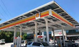
Converting gas stations to solar has been modeled before. In London, Shell upgraded a gas station with nine EV chargers, rated at 175 kW each, capable of recharging EVs to 80% capacity within 10 minutes. The charging station includes a convenience store, where EV owners can wait or buy groceries while their cars recharge.
In Buckhead, Georgia, a private owner of a Shell station replaced their traditional gas station canopy with solar to provide a weatherproof cover for
customers and provide clean, renewable solar energy to help power the station.
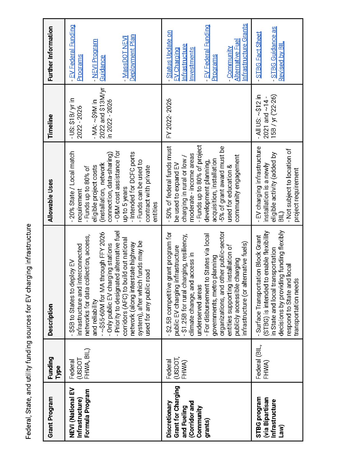
Federal and State agencies as well as utilities have all allocated funding toward deploying, supporting, and investing in EV charging infrastructure.
In November 2021, as part of the Bipartisan Infrastructure Law, the NEVI program was created to provide EV infrastructure and interconnected networks, which requires a state or local funding match. As part of this legislation, there is also a competitive grant program for public EV charging, in which 50% of funds must go to rural or low- or moderate- income communities. Additionally, several changes were made to existing grant programs (such as, the Surface Transportation Block Grant) to designate EV infrastructure an eligible activity. Massachusetts also has incentive programs (Mass EVIP) for property owners that can cover as much as 100% of costs for governmentowned lots, funding up to $50k per street address.
The attached table in the Appendix summarizes primary federal, state, and utility funding sources along with key considerations, such as allowable uses and relevant timelines.
In addition to available funding for EV infrastructure, there are several state and federal programs to incentivize solar facility installations.
The most notable funding source is the Investment Tax Credit Act (ITC), which offers a dollar-for-dollar 26% federal tax credit that can be applied to the total equipment and installation costs of solar panels.15
If a third-party owned partnership model were pursued, the project may also be eligible for the Solar Massachusetts Renewable Target (SMART) Plan, the state-sponsored solar incentive program. The Department of Energy Resources pays $0.06 for each kWh generated for up to 10 years. This could amount to up to around $150,000 total.16

Additionally, sales and property tax exemptions, as well as the Modified Accelerated Cost-Recovery System (MACRS), can help to recover some of the costs associated with commercial solar panel installations.17
Business Transition Capital Funds are a potential funding source of interest to subsidize the container space in the site plan.18
For additional guidance on navigating and securing available funding, see resources from the Electrification Coalition and the World Resources Institute (US EV Charging Infrastructure Funding). An overview of alternative financing options, such as, local loans, state infrastructure banks,
bonds, and other tools are described in the U.S. Department of Transportation federal funding application process .
The primary costs can be broken down into several categories: equipment, installation, and operations and maintenance. Further detail on what comprises each cost category and estimated cost ranges are described in the summary table above (Figure 76).
As a note, EV cost estimates range greatly depending on charging station characteristics. Based on research, the average cost for a Level 2 charging station (equipment and installation) is

around $6,000 and a fully-installed Level 3 DCFC is around $50,000.19
Level 2 charging stations are appropriate for residential, commercial, or public locations. The site plan for SunStation assumes L2 stations for the purposes of this analysis. For reference, Figure 77 is a comparison of the features of L2 v. L3 charging stations.
There are certainly pros and cons to choosing L2 v. L3 DCFC stations. Benefits of L2 include: broad site applications, affordability and cost-effectiveness given charging capacity, and previous precedent for L2 in greater Holyoke. The main drawback is the EV miles of range per charging hour and total time to fully charge, which could potentially diminish

attractiveness to EV drivers deciding where to stop for charging. Depending on the level of grant funding secured and willingness to pursue financing options (loans, etc), L3 DCFC could be an alternate viable path forward (as a note, fully-loaded costs, particularly O&M, for L3 stations can vary greatly).
Estimated EV-Only Capital Costs: Short-Term v. Long-Term

Figure 78 shows estimated total costs for EV charging stations on-site in the short-term (8 stations) and long-term (10 stations) described for both L2 and L3 DCFC charging station types.
EV-Only Capital Costs: Sources and Uses (ShortTerm)
Figure 79 shows illustrative examples of “sources and uses” charts for L2 charging stations and L3
DCFC stations for the entire site in short-term vision (8 stations).
For L2 stations, the MassEVIP grant money, if secured, funds up to $50,000 per street address (100% for government-owned), which covers the full cost. L3 DCFC charging stations would require accessing the NEVI (80% coverage if State / local match) and National Grid / MA Department of Public Utility funding to cover the remaining (20%). As a note, this is an illustrative example and other funding arrangements are possible as well.

Additional Resources: Business Models and Financial Analysis Tools
The following resources may be of interest when considering EV charging business models and conducting financial analyses to inform investment in EV infrastructure.
Business Models:
• Center for Climate and Energy SolutionsBusiness Models For Financially Sustainable EV Charging Networks
• State of Electric Vehicle Charging Station Finance
• Atlas Public Policy - Business Models for Retail Site Hosts
Financial Analysis Tools:
• Atlas Public Policy EV Hub - EV Charging Financial Analysis Tool (linked to by US DOT )
• Atlas Public Policy EV Charging Financial
Analysis User Guide
• NREL Electric Vehicle Infrastructure - Financial Analysis Scenario Tool
• NREL EV Financial Analysis User’s Manual
There are several models that Holyoke could follow to develop the SunStation.
1. Holyoke develops existing city-owned lots, or purchases parcels from private owners.
2. Solar facilities and EV chargers are purchased and installed with city funds, leveraging grants, bonds, and other incentives described earlier (see Funding).
3. The operations and maintenance are managed by the City directly, or contracted out.
4. EV charging revenues are collected by the City.
5. Power generated by the solar facilities can be:
• Stored, transported, and sold to other energy providers.
• Plugged into the existing grid, creating a new renewable energy source for Holyoke Gas and Electric.
• A combination of both.
Pros:
• Viable in all regulatory environments.
• Full control over benefits of solar installations
and EV chargers.
• Revenues per EV charging station are estimated to be about $1500, and are projected to increase to about $4000 per charging station by 2026. 20
• Running rates for solar power are around $0.40 per kWh, and therefore the city could generate up to $88,000 annually in the long term model. 21
Cons:
• High upfront costs.
• The City must assume full risks of construction and operations of the installations.
Long Term Lease
1. The City creates an RFP to identify a third-party developer for the project.
2. The developer finances and installs solar facilities and EV charging stations on a cityowned parcel.
3. The developer and the City enter into a fixed fee lease agreement. The agreement outlines how EV charging station revenues and solargenerated power are split.
4. The developer or the City manage operations and maintenance.
Pros:
• No upfront costs.
• No upfront construction risks, and potential for no operational risks to assume.
• Permitted under local regulations without complication.
Cons:
• Long term costs due to lease agreement.
• Must split the benefits of EV charging stations and solar facilities.
1. A developer finances and installs solar facilities and EV charging stations on a non City-owned parcel.
2. The developer and the City enter into a long term Power Purchase Agreement (PPA). Generally, the cost per kWh is lower than market rate.
3. The developer manages operations and maintenance.
Pros:
• No upfront costs.
• No upfront construction or operational risks to assume.
Cons:
• Long-term costs due to PPA payments, though generally lower than that of Lease Agreement.
• Oftentimes more difficult to establish given regulatory frameworks.
An example partnership model for the High Street SunStation would be as follows:
• The City of Holyoke enters into a long term lease agreement with current owners of Lot 10 (short term) and Lot 9 (long term).
• Holyoke Gas & Electric acquires funds through various channels to cover costs of EV charging station pods and solar facilities.
• Holyoke Gas & Electric completes the installation of charging station pods itself.
• The City of Holyoke creates an RFP to partner with an established Combined Heat and Power (CHP) systems installer for installation and maintenance of small scale solar facilities.
• The City of Holyoke creates an RFP to procure operator entities: one to supervise day-to-day operations of the charging station pods, one to manage the container space (short term), and one to run the coffee shop / convenience store (long term).
• Power generated from solar facilities on the sites plug directly into the existing Holyoke Gas & Electric grid, providing the City with a new carbon-free energy source for its electricity service.
• As Lot 9 transitions entirely from gas to renewable energy in the long run, workers employed by A & A Shell Inc should be provided with reskilling opportunities to ensure job loss is mitigated as much as possible. Workforce development organizations, such as ChargerHelp, could be partnered with to supply EV charging technician training and certification.
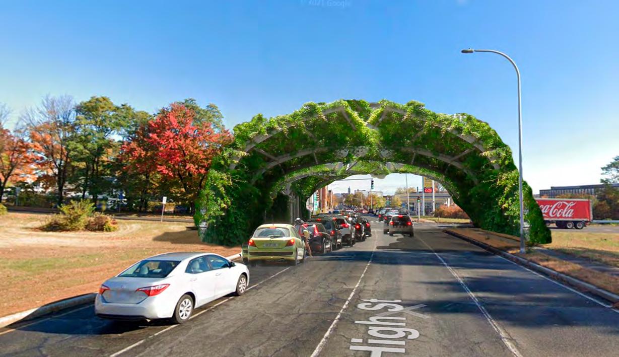
Diane had been driving since 6 am. She left her apartment in New Jersey, crossed into New York on the GW, into Connecticut by 7, through Waterbury and Hartford by 8, heading north along the river, to visit her father in the hospital in Amherst.
She was tired. She got the call late the night before, and realized her car didn’t have enough charge to make the whole trip, but she had to be there.
When she crossed the Massachusetts state line with less than 10% battery, she knew she needed to find somewhere to charge. She could make it past Springfield, but where could she get a charge?
From 391 she took 90 through Chicopee into Holyoke, where she would cross the river again into Granby.
And there, right off 90, was a charging station, gleaming bright in the morning sun!
She drove under a great green arch off the highway, beckoning her onto High Street, and pulled into the station. Below a shining set of solar panels, she plugged her car in.
She walked up to the shop to pay. It was a quiet shipping container repurposed as a shop, humble, but cozy, and painted by a local muralist. The space was warm in the fall morning, and she fixed herself a cup of coffee before stretching her feet.
She walked back to the curious green arch, a simple structure that was supporting climbing plants, virginia creeper and honeysuckle, where they spanned the road and provided shade and their sweet flowering aroma. Their leaves still held dew from the night before, and even though it was on the corner of the highway exit, the plants provided a calm she needed before finishing her drive. She took in the sun as it rose further up, finished her coffee, a few more minutes charging and she would be back on her way, ready for what may come.
Regional market conditions make it difficult for Holyoke to attract and finance market rate developments, and new construction or redevelopment of both housing and commercial space currently requires subsidies to bridge the gap between development costs and generated income. Attracting community development capital— financing designed explicitly to bridge these gaps in historically underinvested and disinvested markets—is critical for projects to be successful and can help achieve other community goals such as job creation, neighborhood stabilization, and wealth building.
This capital is plentiful: community development is a multi-billion dollar industry, and community development financial institutions (CDFIs) manage over $222 billion in assets nationwide. However, smaller municipalities can face difficulties sourcing and effectively utilizing this financing.
Redeveloping the High Street corridor and downtown area at scale requires a coordinated and strategic approach that optimally positions
Holyoke to attract community development capital from a range of investors across geographies and scales.
Building an effective strategy and enabling environment for attracting and deploying this capital requires:
• An audit of the existing community development ecosystem in Holyoke;
• A strong vision of shared community priorities that will inform a development pipeline;
• A transparent system for allocation of resources and identification of redevelopment opportunities; and
• A regulatory environment that supports development in line with these community priorities.
The following sections lay out the key goals, questions to ask, and initial analysis of strategies that Holyoke can employ to most efficiently and effectively attract community development capital and realize a transformative redevelopment vision for South High Street and the broader downtown.

Overall, Holyoke’s community development stakeholders have a range of expertise in affordable housing development and small business financing. Organizations are well positioned to deploy recurring funding sources, such as CDBG funding; develop affordable housing and homeownership models using traditional sources of financing, such as LIHTC and HOME funding; manage relationships with local banks and lenders; and support small businesses and families with nuanced and personal attention. Area stakeholders such as One Holyoke, Wayfinders, and the Housing Housing Authority have well-proven track records of successfully financing and constructing affordable housing
developments that leverage multiple sources of subsidy as well as supporting and developing innovative models, such as scaling the Passive House. EforAll and the Chamber of Commerce have developed proven methods of supporting small businesses and cultivating entrepreneurship across Holyoke’s diverse populations. The City of Holyoke regularly uses CDBG funding to provide small business grants and lending, and local banks provide small business loans as well as lending for smaller property redevelopments through their Community Reinvestment Act (CRA) obligations. Common Capital, the only regional CDFI in the area, focuses on small business investments.
However, a number of gaps exist. Despite the strong focus on small business lending and support, many businesses face challenges applying for
Goals
• Build a comprehensive picture of current community development stakeholders, areas of expertise, and capacities in order to identify strengths and gaps
• Compare the attributes of current and potential resources and funding streams
Questions to Ask
• What are the strengths of existing stakeholders?
• What types of stakeholders are missing?
• What funding sources do we utilize most effectively?
• Where do we typically encounter funding gaps?
Goals
• Create a vision that can inspire change and is grounded in concrete outcomes
• Develop a coordinated plan for allocating limited funding
Questions to Ask
• What are our values as a community?
• What are our shared interests?
• How do we envision the Holyoke of the future?
• What short- and long-term outcomes can we aim for?
• What strategies can help drive those outcomes?
Goals
Goals
• Concentrate and sequence investments in order to maximize impact
• Send clear signals about local priorities to increase confidence and transparency
Questions to Ask
• What parcels are available for redevelopment?
• What are the characteristics of these parcels, and what types of development can they support?
• How can our community priorities drive organization and sequencing of a redevelopment pipeline?
• What types of partners would we need?
• What would those partners need to know, and how can we make that information accessible and transparent?
• Streamline processes to incentivize the type of development desired
• Create a regulatory environment that enables realization of community vision and specified outcomes
Questions to Ask
• How can regulations effectively support community priorities and strategies that drive outcomes?
• Are there institutional practices that are slowing or limiting progress we want to see?
• What procedures could expedite the redevelopment plan?
and accessing state grant funding because of administrative requirements, such as having a certificate of good standing. The changing retail economy has also led to a hesitation with promoting standalone retail stores for entrepreneurs, elevating the importance of and need for more flexible models of space with potentially innovative financing and ownership models. Organizations such as EforAll and the Chamber of Commerce also highlighted the need for coordinated succession planning and capacity building across current non-profits, which could include focusing on attracting and building young, diverse boards of directors and cultivating opportunities for leadership development.
On the development and financing side, larger redevelopments require larger organizations with more institutional capacity. Winn Development, a national affordable housing developer, was selected by the city to redevelop the Farr Alpaca Mill Complex into affordable age-restricted apartments. However, Winn doesn’t specialize in mixed-use redevelopment, the type of redevelopment the city should promote along High Street and other main commercial corridors. In the absence of a strong regional CDFI, Holyoke is also reliant upon national and state CDFIs, such as MassDevelopment, for transformative funding, underpinning the importance of developing local models and guarantees that can help attract this capital. In contrast to other area municipalities, Holyoke also doesn’t have a local foundation or major institutional investors, the types of entities that can typically take on more risk in their investments, leading to a gap in risk-tolerant, equity-like capital such as charitable giving or recoverable grants.
Shared community priorities help determine the most efficient way to deploy limited funding sources in order to attract additional capital, maximizing the funding’s impact. Developing a guiding vision that can inspire change as well as direct focus to specific outcomes is important to help coordinate the allocation of funding and begin to build a development pipeline.
From conversations with stakeholders and a review of past plans, some ideas and themes around
community prioritizes emerge. These include: 1) bringing people to High Street, 2) addressing the downtown food desert and issues of food equity, 3) creating jobs and supporting small businesses, and 4) preserving affordability for existing residents while also building a base for more market-rate housing development. Additionally, over twenty years ago Holyoke’s 1999 Master Plan set an overarching goal to “establish a positive image of Holyoke as lively, attractive, safe, accessible and walkable.”24 As stakeholders articulate a new vision for Holyoke’s future, the city should determine how this objective fits in with other community priorities, and how steps toward this goal over the past twenty years can inform continued progress over the next twenty.
In order to expand on these goals and solicit further input, the city could hold a community visioning and design workshop in order to elevate priorities, identify shared interests, and develop a vision for coordinated future redevelopment. With a strong workshop plan in mind, the city could apply for a HUD Choice Neighborhood Planning Grant in order to fund a transformative visioning process for the downtown as well as access additional funding for implementation. Working through ideas collaboratively can help determine ways to combine varying community interests, envision desired outcomes, and strategize actionable pathways to achieve desired outcomes.
Establishing strong community priorities leads directly into the creation of an effective development pipeline. A transparent development pipeline—with property-level information that’s easily accessible to community members, property owners, potential buyers, developers, and investors—can make the city’s commitment to a coordinated redevelopment vision explicit. Community priorities should be combined with a market analysis and audit of existing vacant and/or underutilized parcels to understand how to prioritize redevelopment projects and allocate limited funding accordingly. For example, if addressing the food desert and supporting small businesses with flexible space are top community priorities and are supported by
“Roundtable participants frequently cited the lack of an investment pipeline as a reason they refrain from investing in small and midsize cities. Such cities can help spur development by providing clear signals about local priorities. They can adopt city plans with sufficiently long horizons. They can do leading work around land assembly, demolition, brownfield remediation, and other predevelopment activities. They can help assemble and package possible projects for investors.”
are selling, can help address affordability and community concerns about being priced out of their neighborhoods as new investments are brought to the area.
Based on this initial analysis, this plan proposes the following three strategies to develop a coordinated community development.
Use limited locally-controlled funding to leverage additional sources of capital and strategically attract larger organizations with the capacity to take on projects outside current community expertise
a market analysis, the city should identify suitable parcels, make this an explicit goal of redevelopment on those parcels, and identify and target funders and lenders with this specific type of expertise.
Regulatory incentives can help enable and spur redevelopment of underutilized parcels on South High Street, providing quality housing, supporting business development and job creation, and creating a vibrant streetscape and neighborhood that drives economic development and nurtures a high quality of life in Holyoke’s historic downtown. Regulations, policies, and laws should help support development in line with the community priorities and should allow the development pipeline to function efficiently. Examples of regulations that can create a successful enabling environment are zoning review and approval processes, while legislation supporting anti-displacement and tenant protections, such as Right-of-First-Refusal for tenant purchase of buildings if current owners
This strategy draws on expertise that the City and local stakeholders already possess and funding sources they frequently utilize in order to catalyze additional interest and investment in projects. Using funding streams that are within the City’s purview to earmark for particular projects, the City can signal their commitment to projects and provide confidence for investors and property owners to make additional investments. Thinking about where this funding is allocated in the capital stack is also important; strategically using grant funding to take the position of first loss or risk as equity within the capital stack can help leverage additional equity investments and/or receive favorable terms for debt financing.
• Community Development Block Grant (CDBG) funding can be used leverage Section 108 loans and bridge specific funding gaps in community development projects that require risk-tolerant capital
• American Rescue Plan Act (ARPA) funding can be allocated to non-profit capacity, industry support, and/or capital improvements to spur economic development
• CCHIP and tax incentives can be used to incentivize market rate housing development on smaller parcels
• Transparent funding commitments earmarked
for particular projects can help attract partners with desired expertise (i.e. mixed-use developers, lenders with a particular expertise/sector focus)
• Identifying new creative sources of risktolerant capital to bridge funding gaps, which could include looking at investors with niche expertise in cooperative lending or food lending, or demonstrating to larger national/regional CDFIs that Holyoke has a plan in place and projects that are investment ready.
based on specified criteria, the City is committed to seeing the development through successfully and has a plan in place for how to do so.
Examples
• Build off HRA map and add other data sources
• Conduct a market analysis to assess community needs and what uses can be absorbed
• Use community priorities to organize and prioritize projects; provide clear guidelines for ordering of priorities in terms of evaluating proposals for projects/sites
Build a searchable redevelopment database aggregating information from Holyoke Redevelopment Authority (HRA) maps and other vacant parcel data that clearly organizes, prioritizes, and demonstrates a transparent system for sequencing redevelopment opportunities
Holyoke already has completed a robust audit of vacant and priority redevelopment parcels through the HRA mapping process completed in 2020. Using these maps as a starting point, the city should aggregate all the parcels across areas and develop a platform that clearly shows prioritization of projects and desired uses, transparent parcel level information (city-/privately-owned, zoning, environmental considerations, market value, etc.), and city processes for submitting proposals for redevelopment.
In addition to providing a platform for redevelopment proposals, the database could also provide information on vacant, city-owned lots that are open to public proposals for temporary uses. By creating a list of pre-approved temporary uses, building off the recommendations described in the public realm section of this report, the City could create a streamlined way for community members and organizations to apply for a permit to temporarily use a priority city-owned vacant lot. Community members could also submit additional ideas for temporary uses through the portal.
Providing upfront, easy to access, and understandable information about city and community priorities for redevelopment and use of vacant parcels can inspire confidence across property owners, community members, investors, and others that once selected
• Make sure that the pipeline is visible, transparent, and accessible
Amendments to the zoning ordinance aim to spur redevelopment of underutilized parcels on South High Street in order to provide quality housing, support business development and job creation, and create a vibrant streetscape and neighborhood that drives economic development and nurtures a high quality of life in Holyoke’s historic downtown. The specific recommendations below are meant to address vacancies, build property values, and help generate development in line with the overall redevelopment vision for South High Street and the broader downtown.
Eliminate BH (Business Highway) zoning on South High Street; change to BC (Downtown Business) zoning
As described in the Existing Conditions section of this report, most of South High Street is already legally nonconforming in terms of allowable building shape and density, including parcel sizes, building heights, and front, side, and rear yard requirements. This change will eliminate restrictive dimensions instead of adding new restrictions in the area, making it easier to develop the type of dense, mixed-use buildings that lead to a vibrant streetscape and making the zoning synonymous with the current North High Street zoning. Allowing for this mixed-use development as-of-right can also lead to increased tax revenues for the city in the future, as tax revenues
from new development at this scale will outweigh the revenue-producing capabilities of properties that are currently vacant or underutilized.
Under this change, existing businesses such as the auto body shops could continue operating as they currently are and would be able to make improvements to their buildings, sell, or transfer to others. Establishing upfront that these uses will still be allowed as legally nonconforming uses is critical to establish broad public support for the change. Giving property owners the option to keep these uses legally non-conforming in perpetuity can also help allay fears that the zoning change won’t allow them to resell or will diminish their property values.
Design standards can be used to regulate desired (and undesired) characteristics of new development in the Downtown area. Holyoke’s zoning ordinance already specifies design standards for dwelling units in accessory structures, special permits for offsite parking, Flexible Development, Planned Unit Development, solar facilities, the Low Density Multifamily District, major site plan review, and the Smart Growth Overlay District.
In order to develop a vibrant, mixed-use commercial corridor on High Street that promotes streetscape activity and the historic character of the area, new design standards can be implemented for Major Site Plan Review in the Downtown Business (BC) zone. These could include:
• “Designs should optimize streetscape activity and pedestrian interaction with ground floor uses along sidewalks;”
• “Designs should conform to the historic character of the district; and”
• “Any on-site parking, when applicable, should be designed and located in a manner consistent with the above criteria”
Eliminate minimum parking requirements for multifamily residential uses in Downtown Zones (DR, IG, or BC zones)
Eliminating parking minimums can be contentious,
but when framed in terms of revenue-generation for the city and future-thinking land use planning that fits into a downtown vision that stakeholders want to see, it becomes both doable and highly beneficial to the city as a whole. In order to prioritize pedestrian interaction with ground floor retail uses, community cohesion, and a vibrant streetscape, downtown Holyoke must not continue to prioritize parking in new developments.
It’s important in the long term to make sure land use is future-thinking and dynamic. As development starts ramping up and people are able to take advantage of the beautiful, dense, walkable streetscape in downtown Holyoke, land that’s committed for parking can detract from the streetscape as well as take up valuable space that could be generating revenue for the city. Generally, it’s easier to just not build parking at all than to build it and then try to take it away in the future when it begins to significantly detract from the downtown landscape. Required parking also quickly drives up costs for developers, particularly of multi-family developments, taking away valuable revenue generating space that could be used for additional housing or other uses. Given the major challenges already present in financing development downtown, the City should be focused on strategies such as this which eliminate unnecessary costs for developers. Finally, eliminating minimum parking requirements doesn’t mean development can’t provide parking, only that it doesn’t legally have to, providing a stop-gap if parking is indeed necessary.
Holyoke is well positioned to become Massachusetts’s renewable energy poster child, and streamlining regulatory processes for renewable energy land uses is a critical component of achieving this goal. Solar facilities already have design standards specified in the zoning code. Adjusting these standards by removing shielding requirements or adding in flexibility to shield requirements can help make solar easier to implement in Holyoke, while still preserving review ability.
Allow electric vehicle (EV) charing infrastructure as a Principle Use as-of-right in all zoning districts with site plan review from the Planning Board Similar to the above recommendation, allowing EV sharing infrastructure as-of-right can help streamline regulatory barriers to EV adoption across Holyoke and Western Massachusetts and promote Holyoke as a renewable energy friendly city. Site plan review for infrastructure can be similar to solar site plan review, and include a location map, site plan, project plan, and operations and maintenance plan. Expanding this Principle Use as-of-right designation to all zoning districts also becomes important if the Business Highway zoning district is eliminated, as recommended above.
Finally, amending signage regulations can activate vacant storefronts in the short term while also helping direct and generate public activity across the streetscape. Changes should include:
• Allowing wayfinding signs in public streets
• Allowing for electronic signs that can change more often than every 24 hours
• Increasing surface area of signs in BC to 84 sq ft by right
• Allowing window signs to take up more than 20% of window space in vacant buildings
Throughout this report, we have included a mix of recommendations that are implementable in the near-term as well as longer-term aspirations. However, there are several action steps that we would encourage city and community leaders to prioritize now, to plant the seeds for more activity along South High Street and create the conditions for future revitalization.
First, we would urge the City to change the zoning code for this area, with particular emphasis on eliminating the Business Highway district designation in the southernmost part of the corridor. As discussed in the report, South High Street’s zoning requirements should indicate what type of development the city would like to see there in the future. Instead, the current provisions limit the density and mix of uses that have made North High Street’s revitalization to date possible. A clear zoning code aligned with the vision of a vibrant South High Street lowers the risks for developers who might bring the exact types of transformative projects Holyoke would like to see in this area. And while there will undoubtedly be political resistance, these changes would not prevent existing business owners from continuing to operate successfully over the long-term. But in short, major change can’t come to South High Street if the rules don’t allow for it.
Secondly, Holyoke can begin to experiment with flexible placemaking strategies. While there has just been substantial investment in street infrastructure through the ongoing MassDOT project, many strategies would complement this work with
improvements to the sidewalk or built environment in ways that don’t impact the street. Artistic bicycle racks, public art installations or street furniture could be piloted in relatively low-cost and low-risk ways to enliven the street, as the city considers more systematic ways of programming currently vacant lots.
Finally, the City should continue its ongoing efforts to talk with and support potential housing developers, while encouraging them to consider South High Street. Our analysis found this area to have great potential for affordable and even marketrate housing. But every site will, of course, pose its own unique challenges to a successful project. Bringing development to this area will likely require every tool in the City’s current robust toolkit–as well as new capacities to leverage capital and support commercial development, as discussed earlier.
Throughout our work on this project, we were struck by elements of South High Street’s beautiful and historic built environment, the vibrant community we encountered on our site visit, and the commitment of civic and city leaders to see this area thrive. It has been a privilege to explore ways that Holyoke might build on these assets and the extensive work done so far to create an economically and socially thriving neighborhood.
We believe that these initial steps– and all of the recommendations contained in this report–can help unlock this potential and ensure that future investors, developers, business owners, and residents in the area are able to see the opportunity along South High Street.
1 Raymond Smith, WGI “Parking Structure Cost Outlook for 2020,” https://wginc.com/wp-content/ uploads/2020/07/Parking-Construction-Cost-Outlook. pdf.
2 Richard Harris, “Appleton-High Street Area Opportunities Assessment,” August 2022, 61.
3 Rapid Recovery Plan: City of Holyoke, 2021. https://www. mass.gov/doc/holyoke-rrp-final/download
4 Finnell, W. Kyle, Sean Hagan, Harrison Takeno Houser, “A Spatial Analysis Supporting Holyoke’s Food System,” Winter 2022, 21.
5 UMass Amherst Donahue Institute, “Springfield and Pioneer Valley Housing Phase II,” January 2022.
6 Carlson, Michele, Willa Caughey, and Nelle Ward, “Green Streets Guidebook for the City of Holyoke, Massachusetts,” 2014, 9.
7 Carlson, Caughey, and Ward, “Conway School Green Streets Guidebook for Holyoke,” 2014, 9.
8 Julia Duranti-Martínez, “Commercial Community Ownership as a Strategy for Just Development,” 2022.
9 “Alternative Fuels Data Center: Electric Vehicle Charging Station Locations.” https://afdc.energy. gov/fuels/electricity locations.html#/find/ nearest?fuel=ELEC&ev levels=all.
10 Dennis Hohenberger. “Holyoke Gas and Electric Plans Downtown Electrical Vehicle Charging Stations.” MassLive, February 25, 2022. https://www.masslive. com/news/2022/02/holyoke-gas-and-electric-plansdowntown-electrical-vehicle-charging-stations.html.
11 Maxine Joselow. “Gasoline Car Sales to End by 2035 in Massachusetts.” Scientific American, January 8, 2022. https://www.scientificamerican.com/article/gasolinecar-sales-to-end-by-2035-in-massachusetts/.
12 Holyoke Gas and Electric. “Solar Energy.” https://www. hged.comsmart-energy/clean-energy/solar-energy/ default.aspx.
13 Peters, Adele. “This Old Coal Plant Is Now a Solar Farm, Thanks to Pressure from Local Activists.” Fast Company, January 3, 2019. https://www.fastcompany. com/90286009/this-old-coal-plant-is-now-a-solarfarm-thanks-to-pressure-from-local-activists.
14 “Energy & Environmental Affairs Data Portal.” https:// eeaonline.eea.state.ma.us/portal#!/search/wastesite/ results?TownName=HOLYOKE.
15 Energy.gov. “Solar Investment Tax Credit: What Changed?” https://www.energy.gov/eere/solar/ articles/solar-investment-tax-credit-what-changed.
16 “225 CMR 20.00: Solar Massachusetts Renewable Target (SMART) Program” https://www.mass.gov/ doc/225-cmr-2000-final-071020-clean/.
17 EcoWatch. “Massachusetts Solar Incentives (Rebates,
Tax Credits & More in 2022).” https://www.ecowatch. com/solar/incentives/ma.
18 “Biz-M-Power Grant Program | Mass Growth Capital Corp.” https://www.empoweringsmallbusiness.org/ what-we-offer/bizmpower.
19 “How Much Do EV Charging Stations Cost? Expect $6,000 On Average.” Property Manager Insider, August 24, 2019. https://propertymanagerinsider.com/howmuch-do-ev-charging-stations-cost/.
20 Statista. “Global: Revenue per Charging Station 20162026.” https://www.statista.com/forecasts/1307503/ worldwide-total-revenue-per-charging-station
21 “Electricity Rates by State Electric Choice.” https:// www.electricchoice.com/electricity-prices-by-state/.
22 Michael Nicholas. “Estimating Electric Vehicle
Charging Infrastructure Costs Across Major U.S. Metropolitan Areas.” The International Council on Clean Transportation. August, 2019. https://theicct.org/ sites/default/files/publications/ICCT EV Charging Cost 20190813.pdf; “Alternative Fuels Data Center: Charging Infrastructure Procurement and Installation.” https://afdc.energy.gov/fuels/electricity infrastructure development.html.; “Costs Associated With NonResidential Electric Vehicle Supply Equipment.”https:// afdc.energy.gov/files/u/publication/evse cost report 2015.pdf
23 Michael Nicholas. “Estimating Electric Vehicle Charging Infrastructure Costs Across Major U.S. Metropolitan Areas.” The International Council on Clean Transportation. August, 2019. https://theicct. org/sites/default/files/publications/ICCT EV Charging Cost 20190813.pdf “How Much Do EV Charging Stations Cost? Expect $6,000 On Average.” Property Manager Insider, August 24, 2019. https:// propertymanagerinsider.com/how-much-do-evcharging-stations-cost/.
24 City of Holyoke. 1999. Masterplan. https://www.holyoke. org/departments/historical-commission/master-plan/
• Federal, State, and Utility Funding Sources for EV Charging Infrastructure
• Key Resources and Funding Streams for Community Development