


OPEN SPACE AND RECREATION PLAN TOWN OF LEXINGTON | DECEMBER 21. 2022 DRAFT

This report was prepared by a Project Team made up of representatives from the Division of Conservation and the Recreation & Community Programs Department alongside private-sector consultants retained by the Town of Lexington. Over the course of the update, the Project Team collaborated with many groups and individuals in Lexington whom the Team wishes to recognize and thank for their work and participation.
The Project Team would like to thank the members of Town staff for providing the assistance and expertise needed to update the materials included in the report. In particular, thank you to the members of the Engineering Division and the Department of Public Works for their assistance in updating the inventories of physical resources; Judy Baldasaro, GIS/Database Administrator for her assistance in updating the open space inventory and creating maps; and Hemali Shah, Chief Equity Officer, and Kate DeAngelis, Therapeutic Recreation Specialist for their assistance in reviewing the contents of the report from a lens of diversity, equity and inclusion.
The Project Team would like to thank the members of a number of Town-sponsored boards and committees for their attendance and feedback at meetings held throughout the update process. In particular, thank you to members of the Commission on Disability, Community Preservation Committee, Conservation Commission, Greenways Corridor Committee, and Recreation Committee for their participation and guidance at small-group stakeholder meetings. The Project Team would also like to thank the community members who participated in the public forum for their comments and feedback.
The Project Team would like to thank all the community members who participated in the statistically valid survey and the online open survey for taking their time to provide their opinions on the open space and recreation offerings in Lexington. The feedback received from the surveys has provided the Town with critical insight into the priorities and values of its residents, which will help to influence improvements and investments over the next seven years.
Finally, the Project Team would like to recognize the Town departments, committees, boards, non-governmental organizations, and community members who have worked over the last seven years on any of the many other published master planning efforts in the Town of Lexington that the Project Team consulted to inform the community priorities and goals set forward in the OSRP.
In return, the Town of Lexington thanks the Project Team for their efforts in updating the 2022 Open Space and Recreation Plan. The input and excitement from all team members shows the dedication the Town of Lexington has to its continued growth, success and service to the people of Lexington. This Open Space and Recreation Plan will continue to provide guidance and accountability towards improving the open space and recreational areas in Town.
Conservation Division
Karen Mullins Conservation Director
Amber Carr Conservation Coordinator
Department of Recreation & Community Programs
Melissa Battite Director of Recreation & Community Programs
Peter Coleman Assistant Director of Recreation
Christine Dean Community Center Director
Town Manager’s Office
James Robinson Management Fellow
ACTIVITAS
Megan Buczynski Principal Civil Engineer
Olivia Messenger Landscape Designer


Ryan Murray Assistant Director of Community Research
Austin Hochstetler Principal

Acknowledgments i
Table of Contents iv 1
Plan Summary 1 2
Introduction 3
• Statement of Purpose 3
• Planning Process and Public Participation 4
• Enhanced Outreach and Public Participation 6 3
Community Setting 7
• Regional Context 7
• Infrastructure 9
• History of the Community 11
• Social and Economic Factors 13
• Demographic Implications 23
• Growth and Development Patterns 25 4
Environmental Inventory and Analysis 29
• Geology, Soils and Topography 29
• Landscape Character 33
• Water Resources 34 • Vegetation 40
• Fisheries and Wildlife 44
• Scenic Resources and Unique Environments 47
• Environmental Challenges 50 5
Open Space and Recreation inventory 55
• Inventory of Open Space and Recreation Resources 57
• Park and Open Space Equity 59
6 | Community Goals 81
• Boards and Committees 81
• Public Meeting 84
• Statistically-Valid Community Survey 89
• Community Synthesis 98
7 | Analysis of Needs 99
• Related Planning Context 99
• Summary of Community Needs 105
• Summary of Resource Protection Needs 106
• Summary of Management Needs 109
8 | Goals and Objectives 113
• Vision Statement 113
• Updating the Goals 114
• 2022 OSRP Goals 120
9 | Seven Year Action Plan 123
• Accomplishments Since 2015 124
• Seven Year Action Plan 132
142
• Glossary of Terms A
• History of Open Space Planning B
• Important Open Space and Recreation Resources C
• Community Survey D
• ADA Study E
• Letters F
Over its long and illustrious history, the Town of Lexington has demonstrated a remarkable commitment to providing to its citizens a wide array of open space and recreational land, opportunities, and other resources. These spaces and programs are a well-loved asset and are deeply integrated into the quality of life enjoyed in Lexington. As such, it is important that the Town provision for their continued protection and preservation through long-term, comprehensive planning efforts. The Open Space and Recreation Plan (OSRP), which updates the Town’s inventory of open space and physical resources and generates guiding principles for their continued management and development, plays a critical role at the center of these undertakings.
The OSRP is a living document built on a framework put in place by the Massachusetts Executive Office of Energy and Environmental Affairs (EEA) Division of Conservation Services (DCS) and updated by each municipality every five to seven years to revisit their individual goals, objectives, and needs. In Lexington, this plan is co-authored by the Conservation Division and the Recreation & Community Programs Department. The overarching objective of the OSRP Update is to continue to expand, maintain, and protect open space and recreational assets within the Town of Lexington while considering equity and stewardship of these assets. The plan as developed has broadened the goals for the OSRP to create an improved framework which the proposed action items descried in Chapter 9: Seven-Year Action Plan can fall within and apply to the actions of both the Conservation Division and the Recreation & Community Programs Department. The main themes under which the goals were developed are:
• To encourage increased coordination between Town departments/divisions, especially the Conservation Division and the Recreation & Community Programs Department and the Conservation Commission and Recreation Committee,
• To consider better alignment of goals and initiatives between departments,
•
To continue to prioritize the protection, maintenance, and appropriate use of open space and recreational areas throughout Town.
Public engagement opportunities conducted over the course of the update identified issues of conflicting interests within Town as a significant threat to progress towards departmental objectives. Since 2015, the Town of Lexington and constituent departments have undertaken a number of comprehensive planning and goalsetting efforts. The authoring groups have each generated their own lists of ambitious and department-specific goals in preceding documents. While these plans were consulted as a source of guidance and inspiration for the OSRP, it was clear to the working group that the OSRP should be written to assist and augment, rather than to supersede or reiterate, their objectives.
In updating this plan, the need to establish new methods of communication and collaboration to mitigate conflict between departmental interests was brought to the forefront. The objectives established in this updated plan are focused on developing critical synergies and connections between the goals of the Conservation Division and the Recreation & Community Programs Department and the goals of other
Town departments and organizations. With this new focus on synergy at the forefront, this 2022 update reflects a departure from the format established in 2009 and 2015. Instead of presenting the plans of the departments as a series of goals to be accomplished, this plan categorizes these objectives into an openended framework anchored by eight concepts building upon and augmenting the nine goals described in the 2015 OSRP in order to remove redundancies and connect to other planning efforts through routes which had not been explored in previous plans. These goals, shown above, are explored in greater detail later in the document in Chapter 8.
The incorporation of the other comprehensive planning efforts into the 2022 update broadens the scope of this work to the Town as a whole. In altering the established format, this plan endeavors to create a reciprocal framework where the work of other departments is considered in the work described in the OSRP, just as paths may be created for open space needs to be considered in the larger scope of comprehensive planning in Lexington.
The OSRP is intended to reflect and advance the missions of the Division of Conservation and the Recreation & Community Programs Department. The mission of the Recreation & Community Programs Department is to provide the community opportunities to engage in quality, inclusive and accessible programs and services, and to be a leader in promoting inclusion, community engagement and a healthy active lifestyle.
The Conservation Division serves three primary purposes: to administer and enforce state and local wetlands protection codes, as well as the state Stormwater Management Policy; to manage over 1,400 acres of Town-owned conservation land and monitor conservation easements and restrictions; and to conduct outreach and education regarding the Town’s natural resources and watersheds.
The purpose of this plan is to provide both a targeted framework and strategy for future growth and management of Lexington’s open space and recreation resources. It is an update of the 2015 Open Space and Recreation Plan and comes following the global COVID-19 pandemic (refer to Appendix B for a summary of past OSRPs dating back to 1976). Municipalities have continued to experience the ongoing effects of the pandemic on community needs. As a result of shelter-in-place and social distancing orders that were in place in 2020 and 2021, towns like Lexington experienced an increased demand for outdoor activities and open space. Though most of the restrictions that caused this increase have been removed by the time this plan was updated in 2022, higher rates of use and participation have remained. The OSRP is intended to reflect these changing community needs and plan for the changes in maintenance and management required to respond appropriately.
The OSRP development process is also used by municipalities to understand changes in community opinions and priorities. Through direct public input, a statistically-valid community survey, and meeting with Town boards/committees, the Project Team learned that the community is looking forward, expressing desires to incorporate climate change mitigation, community agriculture, and universal access into future planning efforts.
An important addition within the Town departments since 2015 is an emphasis on Diversity, Equity, & Inclusion (DEI) with the creation of the Chief Equity Officer position. This position, which operates through the Town Manager’s Office, is tasked with working with senior leadership in Town and engaging the public to incorporate DEI values into Town culture, programs, and policies. The OSRP Project Team underlined the importance of collaborating with the Chief Equity Officer when considering many of the Action Items in Chapter 9: Seven-Year Action Plan, including the addition of a new goal focused on accessibility, equity and inclusion.
This updated plan will assist Lexington in making informed and cooperative decisions about its future open space and recreation policies, connect open space and recreation undertakings to ongoing Town initiatives, and promote ongoing maintenance and support of existing facilities.
The process of updating the plan began in May 2022. The Town retained consultants to prepare the plan and conduct the survey efforts. For a complete list of Working Group participants, please visit the Acknowledgments page at the beginning of this report.
Beginning in May, the Working Group conducted periodic project meetings via Zoom. A full schedule of meetings and presentations, including public forums and stakeholder group meetings, appears below.
Working Group Meeting May 17, 2022 Internal Meeting
Working Group Meeting June 2, 2022 Internal Meeting
Working Group Meeting June 23, 2022 Internal Meeting Working Group Meeting June 30, 2022 Internal Meeting
Public Meeting #1 July 12, 2022 Open Forum
Working Group Meeting July 14, 2022 Internal Meeting
Working Group Meeting July 21, 2022 Internal Meeting
Commission on Disability August 16, 2022 Stakeholder Group Meeting Joint Conservation Commission/Recreation Committee August 23, 2022 Stakeholder Group Meeting
Working Group Meeting
August 25, 2022 Internal Meeting
Working Group Meeting September 1, 2022 Internal Meeting Working Group Meeting September 15, 2022 Internal Meeting
Community Preservation Commission September 15, 2022 Stakeholder Group Meeting Working Group Meeting October 6, 2022 Internal Meeting
Working Group Meeting October 20, 2022 Internal Meeting Working Group Meeting December 1, 2022 Internal Meeting
Working Group Meeting December 15, 2022 Internal Meeting Public Meeting #2 January 10, 2022 Public Forum
Consultants conducted literature reviews and site visits to become acquainted with Lexington’s resources. In June, work on the draft of the Plan was initiated. Throughout the summer, the consultants engaged the public in multiple opportunities for public participation, which will be detailed in the next section. In group meetings, with input from the community survey and public engagement sessions, the Working Group collaborated to update the 2022 OSRP Goals and Action Items. The Division of Conservation and the Recreation & Community Programs Department generated an updated list of accomplishments derived from the 2015 Seven-Year Action Plan. A new Action Plan was created from the updated list of goals. The update of the Lexington Open Space and Recreation Plan was a highly collaborative effort that focused heavily on how to best implement the Plan. Moving forward, residents and visitors will have numerous open space and recreation opportunities to look forward to as this Plan is implemented.
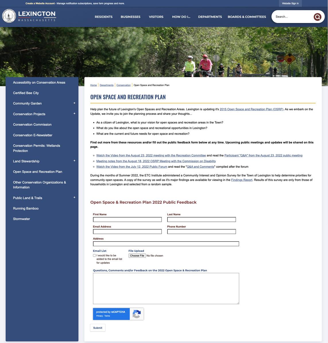
Public input was extensively sought during the planning process through various channels designed to reach the broadest possible audience. The Town created a webpage accessible from the Conservation Division’s section of the official Town of Lexington website to share announcements and updates. Recordings and presentations from the public and stakeholder meetings were uploaded to the site. A contact form was created to request additional feedback. A screenshot of the webpage and contact form is pictured in Figure 1. Additional announcements related to the 2022 OSRP Update were published online on the Town website.
A public forum was held online via Zoom in July, early in the process of updating the Plan. It was intended to inform the public on open space and recreation planning in general, the progress of the Plan, as well as to seek input on how to shape the new Plan. The forum provided valuable insight into what the citizens of Lexington felt the most important areas of the Plan should be and how to successfully fulfill them. Two key exercises were performed at the first public forum to reach these conclusions:
• A Strengths, Weaknesses, Opportunities, Threats (SWOT) exercise;
• A voting exercise designed to validate and update the goals and objectives from the 2015 OSRP. The plan update was also discussed with the Commission on Disability, Recreation Committee, Conservation Commission, and Community Preservation Committee at small-group stakeholder meetings. The format of the presentation was similar to that of the public forum, but targeted questions were developed for each group and were used to guide the discussion towards stakeholder group needs and priorities.
In addition to the meetings held in the update process, there was also a statistically-valid open space and recreation survey distributed by mail to a random selection of households, with the option to complete the survey on paper, over the phone, or online. When the desired threshold of survey responses was reached, a secondary survey was shared online on the project webpage for anyone to complete. While these secondary responses were not included in the statistically-valid survey results, they represented an important opportunity to collect responses from the broader community and to reinforce the information collected from the random households selected.
Chapter 6: Community Goals goes into greater detail regarding the public participation process, and responses collected from the survey, public forums and online contact form are shared in Appendix D
According to MassGIS and U.S. Census data, 9 census block groups out of a total of 22 census block groups in Lexington were identified as environmental justice (EJ) populations. These EJ populations are identified as blocks where either minority or foreign born populations exceed 25 percent of the total block group population. It should be noted that these populations exist throughout Lexington, both within and outside of the neighborhoods identified as EJ blocks. According to American Community Survey estimates, 29.2% of residents in Lexington are foreign-born, almost twice the State average. While English proficiency is high, above 90% in recent estimates, 35.9% of residents also report speaking a language other than English in the home.
The statistically-valid survey was designed to reflect the demographics of the community in areas such as ethnic and racial identity, household makeup, and income levels. In an attempt to reach the broadest possible audience, a cover letter was disseminated with the survey including instructions to complete the survey in another language over the phone.
The 2022 update process also sought to include other marginalized groups in conversation when developing the new goals and objectives. As part of the stakeholder outreach process, the Working Group engaged the Commission on Disability and the Chief Equity Officer to identify priorities for advancing access for people with disabilities and promoting safe and equal access regarding gender and sexuality. The Town has been dedicated to an inclusive and enhanced public outreach process to meaningfully engage all Lexington residents. The various public engagement strategies utilized throughout the planning process were designed to equally reach the broadest possible audience in Town.
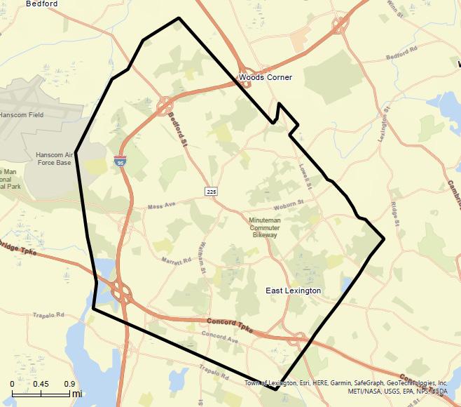
Located 10 miles from downtown Boston, Lexington is a suburban town in Middlesex County, Massachusetts. It is bordered by the municipalities of Winchester, Woburn, Belmont, Waltham, Lincoln, Arlington, Bedford, and Burlington. As described elsewhere in this Plan, there are shared resources among these communities such as the Cambridge Reservoir, a land-locked parcel in Burlington, the Minuteman National Historic Park, the Arlington Great Meadows, and the Busa Farm parcel.
Lexington’s location provides easy access to both Boston and surrounding towns via two major roadways, Routes 95/128 and 2. Because of this, several of Lexington’s roads are used as alternate routes home for those living in surrounding towns and cities. These secondary major roads include: Massachusetts Avenue, Bedford Street, Waltham Street, Woburn Street, Maple Street (Route 2A), and Lowell Street. Although the MBTA Commuter Rail does not connect through Lexington directly, there are local Commuter Rail stations in neighboring municipalities, and the Minuteman Commuter
Figure 1 | Lexington Boundaries
Bikeway passes through the town to connect Lexington to Cambridge, Arlington, and Bedford, terminating at Alewife Station and the MBTA Red Line.
Two MBTA bus lines also make stops in Lexington. The MBTA #62 and #76 pass through Lexington connecting Lexington to Bedford, Arlington and Cambridge and to rail service via Alewife Station. The #78 has one stop in Lexington’s east side. Lexington is also served by the MBTA’s on-demand van service “The Ride”, which provides ADA paratransit for people with physical, mental, or cognitive limitations which inhibits their ability to use public transportation some or all of the time. The Ride operates 365 days/year, from 5AM-1AM and extends to 58 cities and towns.
There are also three Lexpress bus routes in Lexington, connecting Lexington to the MBTA and LRTA in Burlington and to other MBTA buses at Arlington Heights busway. Lexpress is a municipal public shuttle operated in partnership with the MBTA since 1979 to reach placs the MBTA does not travel to.
In addition to major State infrastructure, major Federal infrastructure within Lexington includes the Hanscom Air Force Base and Minuteman National Historic Park, both partially located within the Town. The historic Battle Road Trail that extends through the National Park terminates in Lexington and can be connected to other Town open space areas via ACROSS Lexington (“Accessing Conservation land Recreation areas Open spaces Schools and Streets”) walking paths and marked on-street bike trails.
The Town of Lexington is located in the eastern plateau of Middlesex County at 42.26N Latitude, 71.13W Longitude and contains 10,650.42 acres or 16.64 square miles of land within its bounds. The character of Lexington is formed by its numerous smoothly rounded hills and broad, shallow stream valleys. Some points of topographical importance include: the Town’s highest point at the summit of Whipple Hill, at 374 feet above sea level; the lowest point in Lexington, Tophet Swamp, at 110 feet above sea level; and in the center of Town, Lexington Battle Green, which lies 224 feet above sea level. Geologically, Lexington, like much of surrounding New England, is located on metamorphic bedrock layered with glacial sedimentary deposits that can be traced back to the recession of the last continental ice sheet 12-15 thousand years ago. The Bloody Bluff area represents a unique exposed fault zone where two plates would have collided during the formation of the continent, forming a mountain range which has since worn away. Today, the relief of the underlying bedrock is generally shallow. The hills and ridges of Lexington have no general pattern, and the valleys are drained by small, sluggish streams. One of these streams, Hobbs Brook, supplies a reservoir used by the City of Cambridge for public water supply. Approximately 60 percent of the Town’s area is drained to the Shawsheen River, with the Charles and Mystic Rivers receiving the balance of annual runoff.
The climate of Lexington is marked by four distinct seasons: a long, cold winter; a wet, cool spring; a warm, humid summer; and a wet or dry fall. The warmest month is typically July, and the coolest month is typically January. The Town receives an average of 48 inches of precipitation annually, distributed evenly throughout the year with increases in the spring and summer. On any given day, the average probability of rain ranges from 25-35%. The climate is temperate, with temperatures reaching an average high of 82° F and an average low of 19° F. The growing season lasts for 5.7 months on average, beginning in late April and ending in mid-October.
Today, Lexington is relatively sheltered from extreme weather. Common weather events impacting open space use include occasional heavy rain and snow storms, summer heat waves and winter cold fronts, frost, fog, and high winds. Flood risk in Lexington is low and occurs mostly in preexisting wetland areas, but extreme storms and heavy rains have caused flooding and overloaded storm infrastructure in the past. With climate change, it is predicted that the regularity of extreme weather events will increase, including more frequent extreme storms that may lead to property damage and flooding, extreme temperature events on both ends of the temperature spectrum, and longer periods of drought. An overall increase in the average temperature may worsen the impacts of heat waves on health and natural environment in the coming years and is likely to impact use of open space in Town.
Lexington is crossed by two major highways:
• Route 2, a major connection between Boston and/or the Alewife MBTA terminal/parking facility and western Massachusetts, has three exit/entry points within the Town.
• Route 95/128, the major circumferential highway in eastern Massachusetts since the 1950’s, contains three complete cloverleaf intersections within Lexington; at Route 2, at Route 2A (Marrett Road), and at Routes 4/225 (Bedford Street). The latter ramps are particularly congested during peak commute hours, as they access major office/industrial complexes just outside the Route 95/128 ring as well as Hanscom Field.
The traffic problems associated with these intersection areas have long been recognized and discussed by several task forces including government, neighborhood groups, and area businesses. The Town has required traffic studies for projects where congestion may be a concern and obtained agreements with developers for staggered work schedules and financial contributions to highway improvements and alternate transportation. In 1998, to address increasing traffic congestion and lack of transportation options, the Town developed a progressive Transportation Demand Management policy, still in effect today. To further strengthen TDM efforts an updated TDM policy has been drafted and Transportation Management Overlay District (TMOD) for the Hartwell area has been drafted, as this is a major area of new development.
The Town of Lexington operates Lexpress, a community public bus with three routes that connects Lexington to Burlington and Arlington Heights. The service currently operates 12 hours per day, Monday-Friday, and is open to all. Seniors, youth, people with disabilities and low income people working in hourly wage jobs are the most common riders. Lexpress connects to MBTA bus routes in Lexington, Arlington, and Burlington, and also connects with Lowell Regional Transit Authority (LRTA) service in Burlington.
The Minuteman Bikeway along the old Boston and Maine Railroad right of way from Bedford to Alewife Station was completed in 1993 and is 10.1 miles long. In addition to providing a bicycle commuter route to Cambridge and the Alewife T station, the bikeway provides opportunities for recreational bicycling, walking, jogging, rollerblading, and cross-country skiing, with access to many important areas of historical importance and natural beauty. In 2008, the Minuteman Bikeway was named as the fifth inductee into the Rails-to-Trails Conservancy’s Rail-Trail Hall of Fame.
The Minuteman Bikeway opens up access to existing conservation areas, such as Parker Meadow, Joyce Miller’s Meadows, Arlington’s Great Meadows, and Tophet Swamp, and provides an incentive to protect additional land adjacent to it. In addition, the bikeway provides easy access to the Adams, Muzzey, and Munroe recreation facilities, as well as Bow Street Park and the Community Center.
The Massachusetts Water Resources Authority (MWRA) supplies Lexington with its water and sewer services. Water is supplied to the Town from the Quabbin Reservoir. Most of Lexington is serviced by a public sanitary sewer system and a public water distribution system. The developed portions of town are serviced by a separate stormwater system. For the most part, because nearly all of Lexington has sanitary services available, septic systems are not a major contributing factor in polluting the brooks or groundwater. However, older sanitary sewers, storm sewers, and water lines without modern seals are subject to infiltration/outflow problems.
In 1984, sanitary sewers were improved by the building of the “Millbrook Relief Sewer” along the old Boston and Maine R.R. right of way (Minuteman Bikeway). This link serves sewer needs of Bedford and Hanscom Field, relieving Lexington trunk lines of this burden.
A valuable tool in the management of surface water runoff is the Comprehensive Drainage Study, accomplished over the years 1976 through 1982, by consultants to the Town’s Engineering Division. More

First settled in 1642 and known as Cambridge Farms, town land was used by early inhabitants for agriculture. Farmers were attracted by the availability of hay fields, farming acreage, and the possibilities of land speculation. Early settlers formed their own parish in 1691 to avoid traveling into Cambridge and incorporated Lexington in 1713. Their main emphasis was on clearing and draining the land in the tradition of their European forebears. In fact, they were so successful in execution of this pattern that in 1775 when King George III’s troops were retreating from Concord, they used two field pieces arrayed east of Lexington Center as cover. Because the parcels were so bare with no tree cover at all, they provided a clear line of fire to the British soldiers.
The events of April 1775 inscribed Lexington forever in the pages of American history. Heralded by the midnight rides of Paul Revere and William Dawes, the Lexington Minutemen confronted the British Regulars in the early morning hours on what is now known as the Battle Green. The annual Patriots’ Day celebration and preserved historic sites pay tribute to that fateful time. Lexington remained a quiet farming community until 1846 when the extension of a railroad line from Boston made commuting possible. East Lexington in the mid-19th century had been the scene of debates on such issues as abolition and temperance.
After the Civil War, professionals settled into newly built large Victorian homes on Merriam and Munroe Hills. Railroad access allowed Lexington to flourish as a summer resort, providing a healthy and invigorating atmosphere. Supported by a growing immigrant population, farming would continue to play an important role in the local economy well into the 20th century.
Agriculture is no longer the preeminent land use in Lexington, but it remained unsurpassed until the mid20th century. Following the close of World War II, the increased demand for housing sites accelerated the decline of agriculture and loss of open land. The rising cost of land made farming and holding of large tracts of land increasingly costly and drove many farmers out of business. As a result of the Town’s early zoning bylaws and the construction of Route 95/128, residential growth and the Town’s population accelerated. In 1950, the Town down-zoned the residential districts into what they are today – well after the bulk of the land was subdivided.
Unlike many Massachusetts communities, Lexington experienced little industrial growth during the industrial revolution. The reason for this was the Town’s lack of feasible sites for producing energy via water. So instead of industry springing up in Lexington, it became a vacation spot for well-off Bostonians. In the late 1800’s, several country hotels opened in town to provide fresh air for Bostonians seeking an escape from the city. Today, Lexington is mostly made up of residential neighborhoods. Commercial and industrial research facilities are located along the transportation corridors of Routes 2, 95/128, 225, and Hartwell Avenue. In over 350 years of settlement, the community has mirrored the political times and the changing technology of each era from subsistence farming to a theater for the opening event of the American Revolution; from wilderness to a vibrant community; and from rural to suburban community.
recently, Comprehensive Watershed Management Plans were completed by consultants to the Town’s Engineering Division for each of the three watersheds: Charles, Shawsheen and Mystic, which identified priority projects involving infrastructure improvements and stream and wetland restoration activities. These studies, plus an infiltration/inflow study and program for the Town’s sewer system, has enabled the Town to manage sewers and drainage and to plan needed improvements with sensitivity to the total problem, as well as the possible impacts on wetlands. A new Stormwater Bylaw was adopted in the spring of 2008, as part of the Town’s NPDES permit, which ensures that a wide array of development projects (both by right and by special permit) receive a complete review of their stormwater impacts.
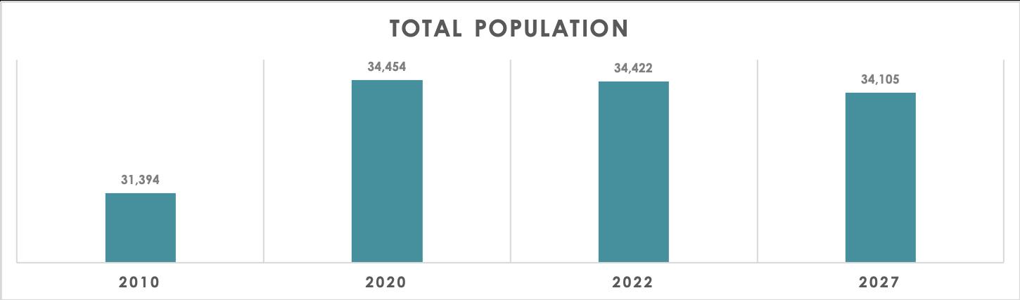
The population of Lexington has increased dramatically since the Town’s inception and is currently home to over 34,000 residents in 2020 (up from 1,893 at the 1850 Census). Demographic information helps Town planners and the like prepare for increased population density, age changeovers (young to old and old to young), and growing/shrinking family sizes (among other characteristics).
All demographic data was obtained from Esri in August 2022. Esri specializes in delivering the world’s most powerful mapping and spatial analytics software available.
Lexington grew by 9.7% between the previous two Census measurements (2010 and 2020). Projecting ahead, the population is expected to hover around the same population for several years, perhaps with a slight decrease. The decrease is most likely projected based upon the last couple years before the 2020 Census in which Lexington’s population decreased slightly by about -.4%.
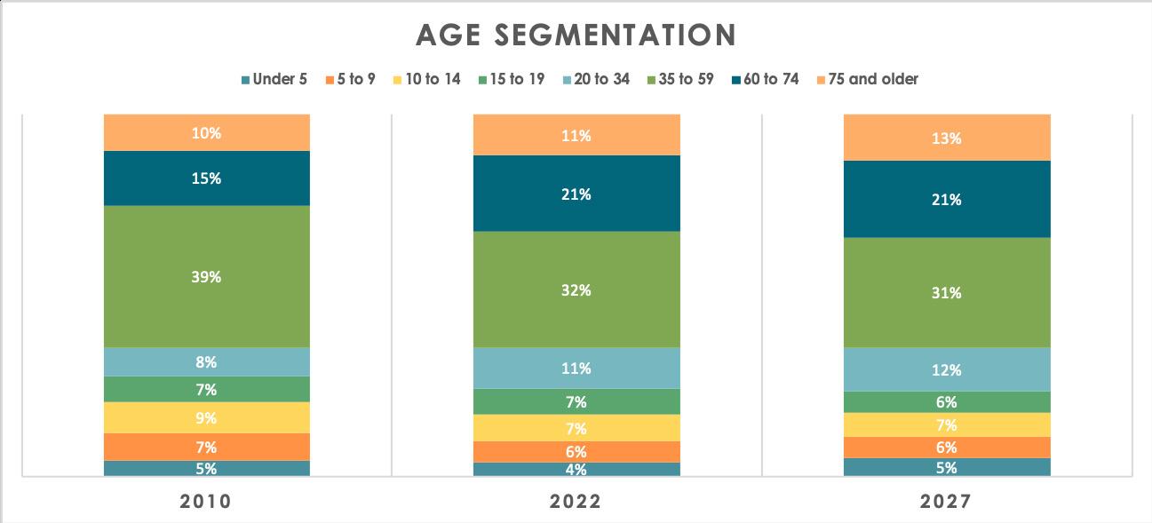
Lexington’s population has been aging since the 2010 Census. In 2010, 39% of the population was between 35-59 years old with 25% being older than 60. Currently, 31% of the population is between 35-59 years old with 32% older than 60. Projecting ahead, an aging trend will continue. Additionally, attention must be paid to younger populations to keep abreast of how those population groups continue to fluctuate over time.
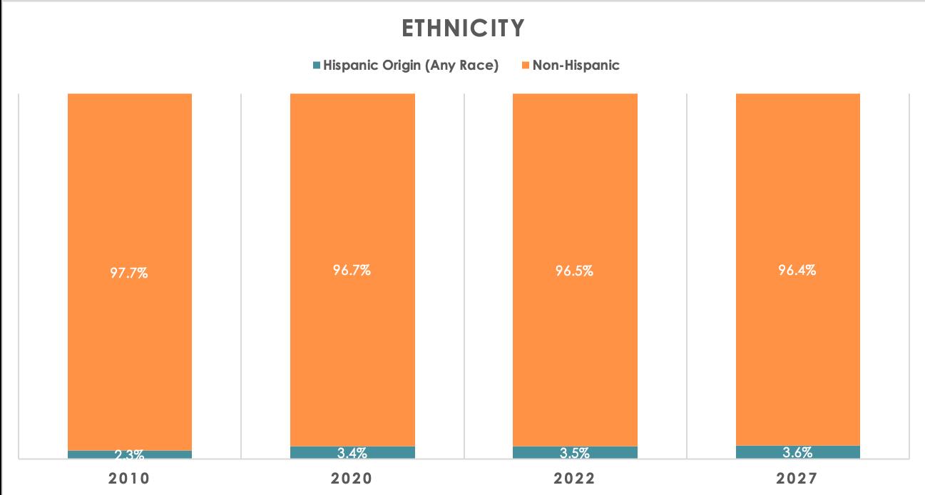
Lexington has experienced a dramatic shift in diversity from the 2010 to 2020 Census. The Asian population has increased by 13%, those identifying as “two or more races” has increased by 4%, and the White population has decreased by 19%. Projections indicate Lexington will continue diversifying over the next Census period. In terms of ethnicity, Lexington has diversified by 1% since 2010. Approximately 3.5% of the total population is recorded as Hispanic or Latino (up from 2.3% in 2010). It should be noted that ethnicity is recorded separately from race as people who identify their origin as Hispanic, Latino, or Spanish may be of any race.
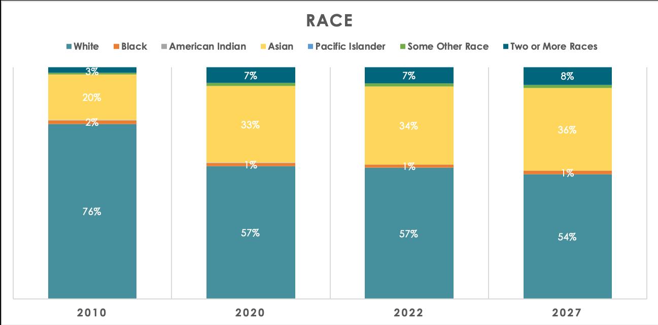
Figure 4 | Race Statistics (2010-2027)
Figure 5 | Ethnicity Statistics (2010-2027)
As community populations change, household compositions change as well. Specifically, the number of households, household sizes, and family sizes all change. Lexington’s number of households increased by approximately 300 the last 10 years. Additionally, average household size has increased. These two correlating trends are important for planning purposes because it is indicative of densification. As more housing units are developed, re-developed, and planned, access to transportation corridors, trails and pathways, green space, and more will become vital proactive quality of life measures to acquire, secure, and preserve.
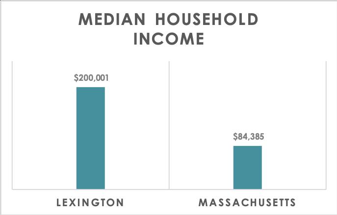
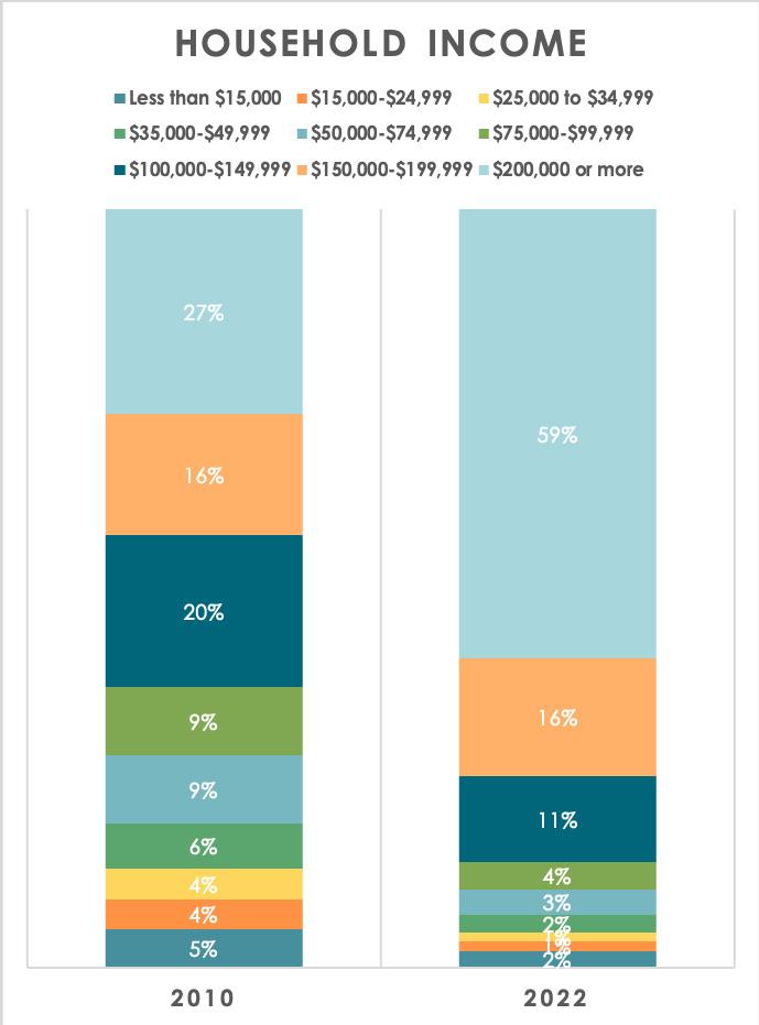
Lexington’s median household income is approximately $200,000, a figure 137% higher than the median household income for the entire state of Massachusetts. This fact is best supported by the change in household income categories between the last two Census years. In 2010, households reporting more than $200,000 income was the largest category with 27% of all Lexington households. Fast forward to 2020 and that figure has more than doubled to 59%. This trend also reinforces the importance of open access for all. As the majority of the population’s wealth increases, there are still residents that report annual household incomes of less than $15,000 (among other income categories). Planning efforts must keep in mind the balance between those residents that have discretionary income and those that do not.
Characteristic 2010 2020 2022 2027
Total Households 11,530 11,849 11,833 11,666
Avg. Household Size 2.68 2.87 2.87 2.89
Figure 6 | Household Statistics (2010-2027)
Figure 7 | Median Household Income (2022)
Figure 8 | Household Income By Category (2010-2022)
Approximately 89% of Lexington’s population (25 years and older) have at least an Associate’s Degree or higher. The next largest educational attainment category a high school degree, followed by those with some college, but no degree.
Level 2022
Less than 9th Grade 0.4% 9th - 12th Grade, No Diploma 0.8%
High School Graduate 5.0%
GED/Alternative Credential 0.7% Some College, No Degree 4.2% Associate Degree 2.3% Bachelor's Degree 27.3% Graduate/Professional Degree 59.3%
Figure 9 | Educational Attainment Statistics (2022)
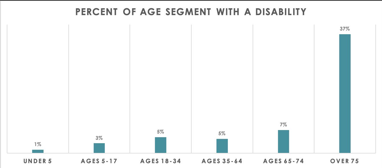
Approximately 7.2% of the Lexington population reports having some sort of disability. Disabilities refer to many different categories including: hearing, vision, cognitive, ambulatory, self-care, and independent living according to the US Census Bureau. Approximately 37% of those over 75 years old report having a disability, a large difference from all other age categories. Still, the breadth and scope of different disabilities and the fact that they are reported for all age segments within Lexington necessitates a closer attention to facility accessibility and providing recreation facilities, amenities and programs with all abilities in mind.
Figure 10 | Disability Statistics (2022)
Lexington experiences relatively modest unemployment rates based on age segments. The largest unemployment rate is for those between the ages of 25 and 54 (7%), but this age segment also has the highest labor force participation rate of all groups (87.4%). The unemployment rate is at or below 4% for the other three age categories.
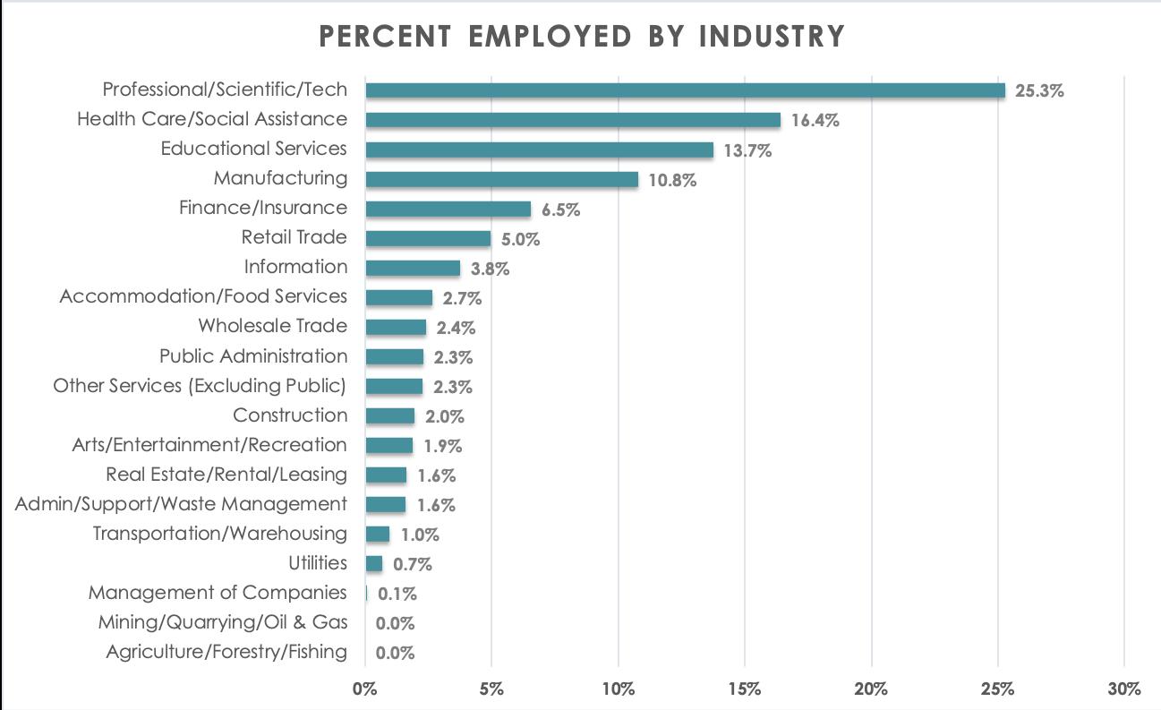
Lexington’s top five leading industries combine to represent approximately 73% of all industries within the town:
• Professional/Scientific/Tech (25.3%)
• Health Care/Social Assistance (16.4%)
• Educational Services (13.7%)
• Manufacturing (10.8%)
• Finance/Insurance (6.5%)
Figure 11 | Employment Statistics (2022)
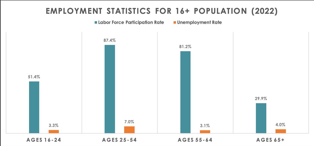
Figure 12 | Industry Composition (2022)
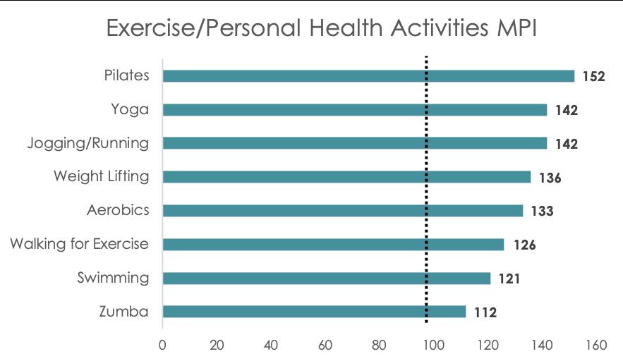
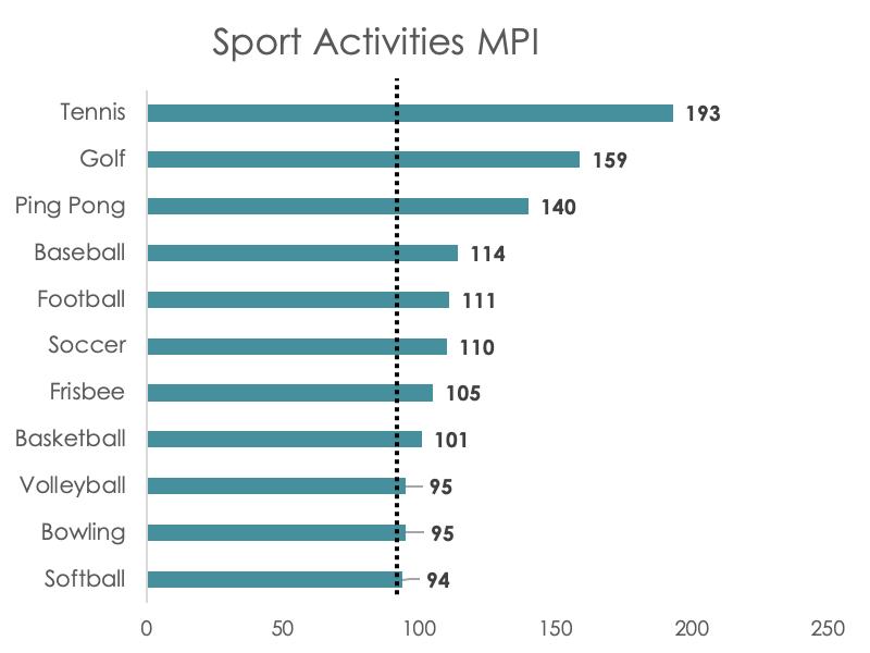
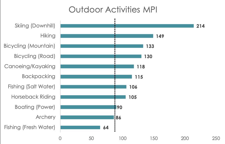
Esri’s Market Potential data measures the likely demand for a product of service in an area. A Market Potential Index (MPI) compares the demand for a specific product or service in an area with the national demand for that product or service. A value of more than 100 represents higher demand, and a value of less than 100 represents lower demand. For example, a service with a score of 125 translates into being 25% higher than the national average.
MPI scores were pulled for three categories:
1. Exercise/Personal Health Activities
2. Sport Activities
3. Outdoor Activities
Exercise/Personal Health Activities: All exercise/personal health activities have higher MPI scores than the national average. More specialized activities such as Pilates and yoga score the highest.
Sport Activities: Only three sport activities score below the national average: softball, bowling, and volleyball; however, these sports are relatively close to the national average scores.
Outdoor Activities: Two prominent factors contribute to high outdoor activities MPI scores: proximity to several outdoor recreation states/ areas and resident household income. Downhill skiing, hiking, and mountain biking are the highest scored activities whereas fresh water fishing, archery and power boating have the lowest scores.
Esri’s U.S. Consumer Spending data is based on the latest Consumer Expenditure Surveys (CEX) from the Bureau of Labor Statistics. The Spending Potential Index (SPI) compares the average amount spent locally for a project to the average amount spent nationally. Like the MPI score, an index of 100 reflects the national average.
SPI scores were pulled for two categories:
1. Entertainment/Recreation Fees and Admissions
2. Sports, Recreation, and Exercise Equipment
Entertainment/Recreation Fees and Admissions: Lexington residents exhibit SPI index scores that far exceed the national average for all recorded activities. Activities that receive the highest average amount spent annually include membership fees for social/recreation/health clubs, fees for recreational lessons, and fees for participant sports (excluding trips).
Sports, Recreation, and Exercise Equipment: Similar to recreation fees, Lexington residents exhibit high SPI index scores for all recorded activities. Purchasing winter sports equipment is approximately 3.5 times more probable for Lexington residents than the average US citizen. Additionally, Lexington residents are more probable to spend over $100 annually on exercise equipment, gear, and related items. Figure 16 |
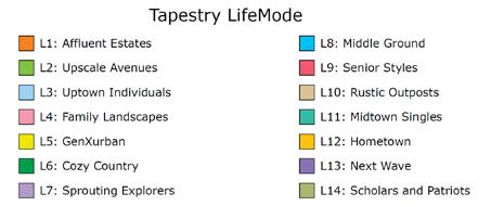

Esri’s Tapestry Segmentation classifies United States neighborhoods into 67 unique segments, based on demographics and socioeconomic characteristics. Tapestry Segmentation allows organizations to understand what makes their customers, or in this case residents, unique. Understanding Lexington’s individual uniqueness can help with planning for programs and services.
Three Tapestry Segments for Lexington account for 100% of the overall population, compared to 3.6% across the U.S. Additionally, the Tapestry Segments can be categorized into three LifeMode groups: Affluent Estates, GenXurban, and Upscale Avenues.
Affluent Estates: This LifeMode’s characteristics include:
• Established wealth – educated, well-traveled married couples.
• Less than 10% of all households, with 20% of household income.
• Homeowners (almost 90%), with mortgages (65.2%).
• Married-couple families with children ranging from grade school to college.
Tapestry Segment (Top Five)
Top Tier
Lexington U.S. LifeMode Group
75.0% 1.6% Affluent Estates
Urban Chic 21.0% 1.3% Upscale Avenues
Pacific Heights 4.0% 0.7% Upscale Avenues
Sum 100.0% 3.6%
• Expect quality; invest in time-saving services.
• Participate actively in their communities.
• Active in sports and enthusiastic travelers.
Upscale Avenues: This LifeMode’s characteristics include:
• Prosperous married couples living in older suburban enclaves.
• Ambitious and hardworking.
• Homeowners (70%); prefer denser, more urban settings with older homes and a large share of town homes.
• Primarily married couples, many with older children.
• Financially responsible.
• Serious shoppers, from Nordstrom to Marshalls or DSW, who appreciate quality and bargains.
• Active in fitness pursuits such as bicycling, jogging, yoga, and hiking.
• Subscribe to premium movie channels such as HBO and Starz.
Top Tier (75%): The residents of the wealthiest Tapestry market, Top Tier, earn more than three times the US household income. They have the purchasing power to indulge any choice, but what do their hearts’ desire? Aside from the obvious expense for the upkeep of their lavish homes, consumers select upscale salons, spas, and fitness centers for their personal well-being and shop at high-end retailers for their personal effects. Whether short or long, domestic or foreign, their frequent vacations spare no expense. Residents fill their weekends and evenings with opera, classical music concerts, charity dinners, and shopping. These highly educated professionals have reached their corporate career goals. With an accumulated average net worth of over $3 million dollars and income from a strong investment portfolio, many of these older residents have moved into consulting roles or operate their own businesses.
Socioeconomic traits include:
• Top Tier is a highly educated, successful consumer market: more than one in three residents has a postgraduate degree.
• Annually, they earn more than three times the US median household income, primarily from wages and salary but also self-employment income and investments.
• These are the nation’s wealthiest consumers. They hire financial advisers to manage their diverse investment portfolios but stay abreast of current financial trends and products.
• Socially responsible consumers who aim for a balanced lifestyle, they are goal oriented and hardworking but make time for their kids or grandkids and maintain a close-knit group of friends.
• These busy consumers seek variety in life. They take an interest in the fine arts; read to expand their knowledge; and consider the internet, radio, and newspapers as key media sources.
• They regularly cook their meals at home, attentive to good nutrition and fresh organic foods.
Urban Chic (21%): Urban Chic residents are professionals that live a sophisticated, exclusive lifestyle. Half of all households are occupied by married-couple families and about 30% are singles. These are busy, wellconnected, and well-educated consumers – avid readers and moviegoers, environmentally active, and financially stable. This market is a bit older, with a median age of 43 years, and growing slowly, but steadily.
Socioeconomic traits include:
• Well educated, more than 65% of residents hold a bachelor’s degree or higher.
• Labor force participation is higher at 68%.
• Residents are employed in white-collar occupations – in managerial, technical, and legal positions.
• Nearly 40% of households receive income from investments.
• Environmentally aware, residents actively recycle and maintain a “green” lifestyle.
• These busy, tech-savvy residents use PCs extensively for an array of activities such as shopping, banking, and staying current – a top market for Apple computers.
Pacific Heights (4%): Pacific Heights is one of the smaller markets (with less than 1% of households), composed of upscale neighborhoods in the urban periphery of metropolitan areas, along the Pacific Coast in California, in Hawaii, and in the Northeast. This market includes the highest percentage of multiracial populations. This is a family market, distinguished by married-couple families, with and without children, some in multigenerational households. They own their homes, mainly high-priced single-family homes, with a higher proportion of town houses. Workers are generally employed in white-collar occupations such as business, computer, architecture, and engineering roles. Median household income and net worth are much higher than the US. These trendy residents buy nice food and clothing, as well as the latest gadgets.
Socioeconomic traits include:
• Education completed: over 67% of residents have some college education; 41% have a bachelor’s degree or higher.
• Labor force participation rate is average at 62%.
• Salaries account for most of the household income among these professionals, but investment income adds to their affluence.
• Financially conservative, these consumers tend to opt for low-risk investments.
• They keep up-to-date with the latest styles and trends, as well as the latest technology.
Block Group Census Tract EJ Criteria Total Population Total Households Median Household Income
Percent Minority Population
Households with Language Isolation
1 3587 Minority 2,243 799 $194,625 45.1% 1.0%
1 3583 Minority 988 369 $219,196 47.1% 0.0%
1 3585 Minority 1,340 435 $250,000 41.3% 0.0%
2 3587 Minority 2,520 863 $191,131 43.7% 4.2%
2 3583 Minority 1,206 390 $148,500 42.3% 8.7%
3 3584 Minority 3,558 1,534 $142,125 42.9% 4.8%
4 3584 Minority 2,264 721 $195,469 53.3% 2.8%
4 3581 Minority 1,664 601 $163,542 44.5% 10.1%
6 3586 Minority 1,063 368 $158,889 46.1% 0.0%
Nine (9) of the 22 census block groups in Lexington are identified as environmental justice (EJ) populations (Figure 20). This is a decrease of two EJ census block groups from 2010. EJ populations are those segments of the population that include high percentages of minority and low-income people that may experience disproportionately high and adverse human health and environmental impacts. Although the number of census blocks has decreased since 2010, they are still up from 2000 when only three EJ block groups were
identified. For Lexington, all existing EJ census block groups are categorized because of high percentages of minority populations (Figure 21). Of note, there are several EJ census block groups that report greater than 4% language isolation, or the term used by the US Census Bureau for limited English speaking households.
Level of service (LOS) refers to the degree in which a community provides services to its residents. LOS metrics typically represent the number of acres/miles/trails/facilities per 1,000 residents. Given the fact that Lexington’s population has densified over the last ten years in particular, the number of and access to open space and recreation amenities, facilities, and services is vitally important. As space redevelops and becomes denser, mixed use spaces and facilities may become more integral in community planning. Therefore, it will be imperative for Lexington to monitor the following:
• Financial investments for existing infrastructure as they will most likely need to keep access available as the community becomes denser.
• Land acquisition and capital development to expand the park system to accommodate new and increased recreation uses.
• Physical access and connectivity points to open space and recreation.
There are two demographic trends that indicate a need to focus on a growing audience: 1) an overall population aging trend and 2) a relatively high percentage of people with a reported disability. First, an aging population necessitates a different portfolio of programs, services, and experiences. More opportunities for gathering and socialization will most likely be required. Second, a population with a relatively high level of reported disabilities necessitates an increased focus on Americans with Disability Act (ADA) facility requirements along with ensuring disabilities beyond physical (sensory, auditory, visual, etc.) are taken into consideration for future system enhancements.
Residents exhibit above average market potential to participate in and spend for various recreational pursuits. Given this information, it is understandable there may be multiple user groups, or special interest groups, that “compete” for space, facilities, and recreation access. Not only will Lexington need to balance active versus passive recreation use, it is probable there will also need to be a balance among active recreation users and passive recreation users themselves.
As indicated by household income statistics and tapestry segmentation, Lexington residents have a large representation of disposable income and wealth. However, there are residents below poverty lines, unemployed, and without close access to quality of life amenities and services. Therefore, open space and recreation planning must have an all-encompassing framework that ensures all residents and abilities are represented and planned for.
1700’s–1900’s
Lexington’s first “open space” property was the Lexington Common, 1.5 acres of land purchased in 1708 from Benjamin Muzzey (another acre of land was purchased in 1772). The Common, today known worldwide as the Lexington Battle Green, was used for ballgames, pasturing cows, cattle shows, picnics, and the like. This was typical of New England’s rural/agricultural communities during the eighteenth and nineteenth centuries, where private property was not as strictly enforced as today. Lexington’s landscape provided residents with spring and summer walks, winter snowshoe tramps, berry-picking, tobogganing, sled rides, and ice-skating, without much concern for whether or not a property was “public.”
Perhaps the earliest effort to create an “open space” after the Common was purchased was in 1835 when Eli Robbins erected a three-story observatory on Mount Independence in East Lexington and built roads and walks intended to increase public access. About fifty years afterward in 1888, James Munroe began to improve his land east of Woburn Street and as a part of this project, built a pond intended for use by the Town’s children for skating. Through the late 1800’s and into the early 1900’s, Lexington continued to depend on private generosities to expand open space and provide recreational opportunities. 1900’s–Present
During the late 1800’s, Lexington’s officials saw the need to improve the Town’s utilities and school system in order to attract residents. Their desire was to keep pace with other towns throughout Massachusetts. These improvements and the rural beauty of the Town caused Lexington’s population to begin to steadily grow during the early 1900’s. With this growth came new streets and homes. Concerned about maintaining the residential quality of the Town while providing services, Lexington citizens established one of the country’s first planning boards in 1918 and adopted its zoning by-laws in 1924. In addition, the first subdivision regulations were established in 1948.
From 1920 to 1940, the Town’s population more than doubled from 6,350 to 13,113. The Town’s most rapid development occurred between 1940 and 1960 when the population reached 28,000. By this time, private property rights were more vigorously enforced and residents depended on the Town to provide them with recreation land and to maintain existing public properties.
In 1947, the Town appointed a temporary Recreation Commission to develop the scope of and establish authority for a recreation program and make recommendations for the establishment of a permanent Recreation Commission. In 1948, the Town voted to appoint a Recreation Committee, and in 1956, the Town voted to establish the Recreation Committee as a by-law committee.
In 1955, the Planning Board proposed and Town Meeting accepted (in 1956) the establishment of a series of Historic Districts in order to preserve the historic aspect of the Town. In 1963, the Lexington Planning Board decided to “take stock” of the Town’s growth. Up to this time, playgrounds and school lots were purchased by the Town one property at a time. Most of the “open land” parcels were taken as tax-title lots. In 1956, total Town-owned recreational acreage represented 1.7 percent of the land within Lexington and by 1962, it represented 5 percent. The Planning Board’s goal was to increase that percentage to 13.7 percent. At the time, the Town was just beginning to make a distinction between those properties designated as “Open Recreational Areas” and those designated as “Conservation Areas.” In November 1963, the Lexington Conservation Commission was formed by Town vote. The Lexington Conservation Commission brought a new perspective to the Town; the Commission members felt that to protect the health of the community, it was vital to protect its woods, brooks, ponds, and fields. The members began to index all the open space available for acquisition. They prioritized each parcel of land and worked toward protecting them, utilizing eminent domain, restrictions, gifts, and purchases. Their primary goal was to protect environmentally important pieces of land, but they also had a secondary goal: to distribute evenly open space land throughout the Town so that each precinct would contain a significant parcel for passive recreation.
Their first purchase was Swenson’s Farm (now included in Dunback Meadow) in 1965. The State reimbursement they received for this purchase was the first to be awarded under the new “Self-Help Plan.” With 90 percent federal funding, this 58 acre parcel cost the Town only $39,550. In 1971, the Commission managed 280 acres of land, while today it manages around 1,400 acres, with properties evenly distributed throughout the Town.
In 2015, the Recreation Department was reorganized and renamed the Department of Recreation and Community Programs with three divisions: Recreation, Pine Meadows Golf Club, and the Community Center. A fourth division, Administration, was added in 2018.
Today, the Conservation Division works closely with the Department of Recreation and Community Programs, although both departments have shifted focus from acquisition to maintenance of existing properties, largely because there is less land available for purchase than in the past.
Until the mid-1990’s, both commercial and residential development in Lexington centered on the use of vacant land. As the supply of vacant, developable land diminishes, new development has increasingly relied on the redevelopment of underdeveloped property, which is land that has not been developed to the maximum allowed by zoning. Since this time, the replacement of underutilized or obsolescent uses by more intensive economic uses has been the predominant development scenario in Lexington, and is likely to remain that way from this point forward.
Lexington’s location in the Boston metropolitan area dictates the process of succession. On the suburban fringe, in the towns near Route 495, development occurs almost exclusively on vacant land. In the substantially built-out central cities and first-tier suburbs of the metropolitan area (e.g., Boston, Cambridge, Arlington, etc.), development occurs almost exclusively through infill redevelopment. Over the last 10 to 15 years Lexington’s development pattern has become more like that of the metropolitan core than the suburban fringe.
Land development and a strong program of land conservation have resulted in a striking reduction in the remaining building capacity of the Town. The Town has largely exhausted its vacant unprotected land supply, with only about 600 acres of the developable land still available in vacant parcels in residential zones, along with some underutilized land within “underdeveloped” areas. Less than 10 percent of these 600 acres is in commercial zones. Vacant land might accommodate an additional 900 dwelling units, and some of that potential capacity is likely to be put to other uses, including open space conservation. Between 2000 and 2012, the Town grew by 638 new dwelling units, the bulk of these (423) were permitted under MGL Ch. 40B. As these projects brought the town into compliance with that law’s 10 percent standard, future growth of new units is expected to slow. In the years since achieving compliance, new residential growth has been less than 20 units per year.
Barring unforeseen regional changes, demand for housing in Lexington will likely grow while housing supply remains stable. Regional housing market forces are likely to continue price escalation, making existing modest homes targets for significant renovations or replacement. It is expected that the trend of land succession is likely to continue as land becomes an ever-growing proportion of the value of residential premises; existing buildings become dispensable to owners under many circumstances. There is much more home building in Lexington than there is net growth, with work supported by tear-down replacement and additions to existing homes, which often eclipse the existing units in size. Population change in Lexington now depends more on the changing demographics of household size and key characteristics such as the age of those who will occupy existing units rather than the small number of constructed new dwelling units.
The mansionization trend will have impacts on the Town’s character, including the loss of relatively modest housing units. On many sites, lot area, frontage, and buildable land allow substantial expansion, even though on many of those sites some development already exists. The rate of building replacement housing is likely to increase. Mansionization is exacerbated by the trend toward a larger residential square footage per capita in the housing market.
L e g e n d T o w n B o u n d a r y S a t e o T o w n A c c e p t e d W a y U n a c c e p e d W a y , P o s S u b d v s o n C o n r o U n a c c e p e d W a y P e S u b d v s o n C o n r o * O h e r F e d e a a n d S a e W a y s M n u e m a n C o m m u e r B k e w a y T r a n s p o r a t i o n M a n a g e m e n t O v e r a y D i s t r c t s D s t r c t F o b e s R o a dM a r e t S e e T M O S o u h L e x n g o n T M O H a r w e A v e n u e A e a T M O N a t o n a l F o o d n s u r a n c e O v e r l a y D i s t r c t F o o d Z o n e D e s i g n a t o n s A 1 % A n n u a C h a n c e o F o o d n g n o B F E A E 1 % A n n u a C h a n c e o F o o d n g w h B F E A E R e g u a o r y F o o d w a y S a n d a r d Z o n i n g D i s t r c t s R E S I D E N T A L D I S T R C T S P D4 P D5 C S X R OO n e F a m y D w e n g R SO n e F a m y D w e n g R TT w o F a m y D w e n g C O M M E R C A L I N D U S T R I A L D I S T R I C T S
o L w U n c c p e W a y m y b s u e c o a a d e u a y d e m a n b h e P a n n n g B o P e s e o n c
a
r m o e n o m a n
c a o n s n o c
h e a s o s e s a s
n
c a c o
p e p e d b h e E g n e n D p a m e n o n o a p p
e d s p a y
m a y c n a n e o o o m s o s W h e a e s o n b b e
s h v e e e n m a d e o a s u e h e
s c h e k n g w h h e P n n g D e p a m e n P e S u bD s o n C o
m a o n r v e d d o n o e y n h
S e e R o d o W a y
M e s
o m a o n w h o u
o n e S e e n d P e n M
o n h e z n n m a b e a u s h e d o o o n o m o e d e n o n
0 8 0 1
0 6
h e Z o n g B yL w D s a m e
0 4
e s w h c h p p e
C BC e n a B u s n e s s C L OL o c a O c e C MM a n u f a c u n g C NN e g h b o r h o o d B u s n e s s C R OR e g o n a O c e C R SR e t a S h o p p n g C SS e r v c e B u s n e s s O T H E R G CG o v e n m e n C v c P L A N N E D D E V E L O P M E N T D I S T R C T S P DP a n n e d D e v e o p m e n C DP a n n e d C o m m e r c a R DP a n n e d R e s d e n a D s t r c t B a t e G r e e n H s o r c D s t c E a s t V a g e H s o c D s c H a n c o c k C a r k H s o r c D s r c M u n r o e T a v e n H s o c D s r c 1 i n c h = 1 , 1 1 9 f e e t 0
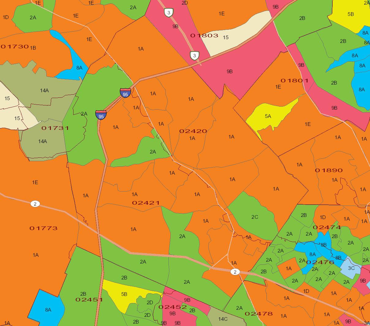
e P a n n D p a m n MAP 3 Zoning Accessed via Official Website of the Town of Lexington at: https://records.lexingtonma.gov/ weblink/0/edoc/2499879/2021%20Zoning%20Map.pdf
0 2
Geology 1
Lexington‘s surficial geology is dominated by very old gravel and sand deposits and glacial till laid down above bedrock during the last ice age. When the Pleistocene Glacier moved down from the north, rocks and soil were scoured from the earth’s surface and mixed together as they were carried forward by the flow of ice. When the glacier retreated, this transported rock and soil was left behind in various types of deposits, such as moraines, eskers, kames, and glacial erratics.
Ground moraines are deposits of unsorted rock and soil that accumulate beneath a glacier or are deposited as the glacier retreats. Ground moraines form many of the low, rolling hills that are characteristic of Lexington. Eskers are narrow ridges of wellsorted sand and gravel that are most often deposited by flowing water within and below glaciers. Examples of eskers in Lexington can be found in the Great Meadow off Maple Street, behind Hancock Street, and beneath Ridge Road (the roadway is an esker top). Kames are irregular short mounds, hills, or ridges of poorly sorted sand and gravel deposited by melt water most often flowing or settling on top of glacial ice. A classic example of a kame is located behind the Adams School. In the past, much of this material was commercially removed, such as along the Lower Vine Brook and Hartwell Avenue. Glacial erratics are large boulders, typically of a different bedrock type than the surrounding bedrock, which glaciers pick up and then drop elsewhere. Glacial erratics are common in Lexington; one example can be found at the corner of Wood Street and Hartwell Avenue.
In addition to depositing moraines, eskers, kames, and erratics throughout Lexington, glacial action also rounded the hilltops that are numerous in town (see Topography in this section for more information on Lexington’s hills). One of the most unusual of these hilltops is that of Granny Hill (also called Merriam Hill), which has a pond on top of it that is thought to be a glacial feature.
Most of Lexington’s bedrock is buried by glacial deposits, but there are a number of bedrock outcrops and exposures scattered throughout town. The town’s bedrock is dominated by igneous rock—pink granite and darker plutonic and volcanic rock—as well as metamorphic gneisses, schists, and greenstones.
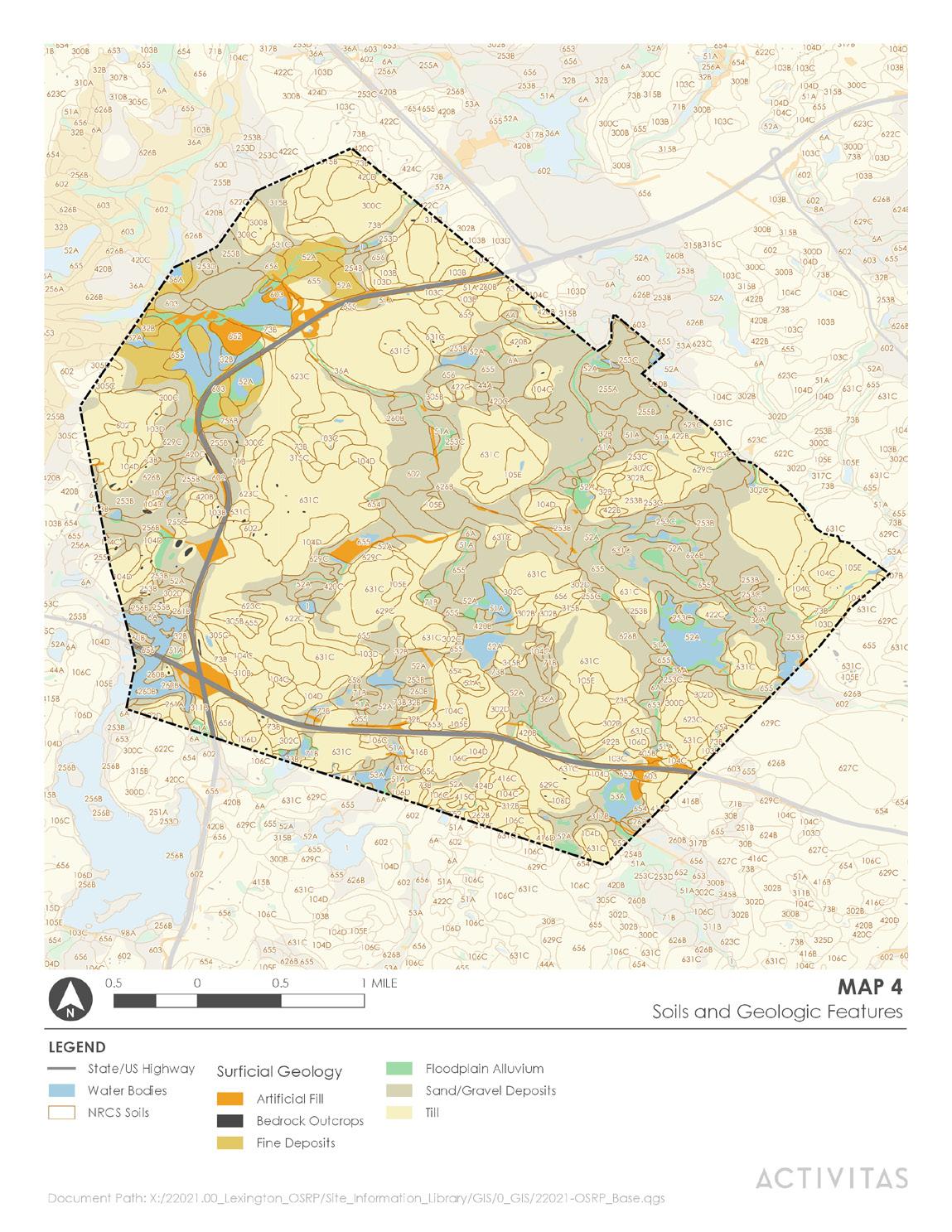
Twenty-nine different kinds of soil in Lexington occupy the landscape in five naturally recurring groups called soil associations, as shown on MAP 4. Depths of soil in town range from two to twenty feet and above. The soil associations are delineated as
1 The following section was drafted upon, The Last Billion Year of the Geological History of the Town of Lexington by Robert Shrock, 1984, Citizens for Lexington Conservation publication # P-9, and Lexington and the Ice Age: A Field Guide by Arthur J Latham and Winston Yelland, date and publisher unknown (located in the Lexington Conservation division office).
general soil areas by the U.S. Department of Agriculture’s Natural Resource Conservation Service (NRCS) as the following:
Hollis-Essex-Paxton-Scituate Association
This association contains shallow to bedrock soils and deep, very stony, well-drained to moderately well-drained soils with hardpans within two feet of the surface. It occupies about 50 percent of the Town. Topography of the area consists of prominent hills, low ridges, and narrow swampy intervals.
Hinckley-Windsor-Au
These are droughty and poorly drained, sandy and gravely soils. This association occupies about 18 percent of the Town. Its topography consists of nearly level to undulating plains with a few low hills. Mining of this association has been extensive in Lexington’s history, with high water tables being the main limiting factor.
Charlton-Hollis-Gloucester Association
These are deep, very stony, well-drained soils with hardpans at depths of three to five feet and shallow to bedrock soils. About 14 percent of the Town is occupied by this association, mostly in the northern section of Town, which is characterized by low hills and narrow intervals.
This association is made up of very poorly drained materials and occupies about 12 percent of the Town.
Deerfield-Muck-Au
This association consists of droughty to poorly drained sandy and gravely soils and very poorly drained organic soils. It occupies about six percent of the Town, with nearly level soil area, a few low knolls and ridges with occasional depressions filled with organic matter.
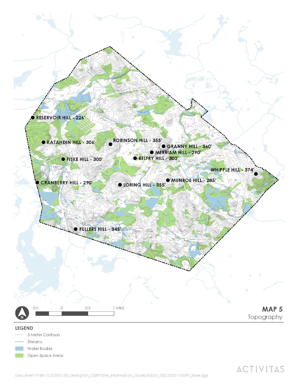
The topography of Lexington bears distinct marks of the glacial period and is characterized by rounded rock hills with an average elevation of 350 feet and flatbottomed valley segments, as illustrated in MAP 5. The highest point in Lexington is Whipple Hill, in the northeast corner of town, which stands at 374 feet above sea level. On the opposite end of the spectrum, the lowest valley in Lexington (Tophet Swamp) is now filled with glacial deposits and is approximately 100 to 125 feet above mean sea level.
Besides Whipple Hill, other prominent hills in town include Brick Hill, Moon Hill, Follen Hill, Munroe Hill, Robinson Hill, Loring Hill, and Cranberry Hill.
Many of Lexington’s valleys were also shaped by various types of glacial activity. Some once held stagnant glacial melt waters and have slowly been filling in since the glacier’s retreat, so that they are now swamps or marshlands. Examples of these include Tophet Swamp and Arlington’s Great Meadow. Others, particularly those sandwiched between the Town’s rocky hills, were carved by rushing glacial melt waters, and they now remain dry except for periods of excessive rainfalls. Many of the flattest areas of town are underlain by sand plains that were deposited by glacial melt water, and they have provided good building sites for the Town’s schools, such as Lexington High School, Diamond Middle School, and Estabrook Elementary School.
The landscape of Lexington is one of immeasurable beauty, much of which has been retained even as the Town has become more densely populated over time. The natural features and protected areas of Lexington’s landscape provide its residents with scenic value, recreation opportunities, and valuable ecosystem services.
Bloody Bluff Fault: The Bloody Bluff, located at the historic Fiske Hill site at the corner of Old Massachusetts Avenue and Marrett Road, is a part of the Minuteman National Historic Park. The Bloody Bluff reveals a section of granite bedrock exposed by the Bloody Bluff fault, which runs through Lexington as it travels approximately 80 miles from Newbury, MA to northern Connecticut.2 The Bloody Bluff fault was first recognized in the early 1960’s by Norm Cupples. This discovery was seen by geologists as an opportunity to examine the theory of plate tectonics, because the Bloody Bluff area hypothesized to be an area of contact between two major continental plates.
Whipple Hill: At 374 feet, Whipple Hill is the highest point in Lexington. Its rounded summit rock and high exposed cliffs that form a shallow ravine are unusual geologic features in town. The top of Whipple Hill is home to plants not otherwise found widely in Lexington, including bear berry and scrub oak. The property features three potential vernal pools and one certified vernal pool. Nearby, a larger secluded woodland pond attracts a variety of wildlife, including American eel, painted turtles, orioles, migrating warblers, dragonflies, and muskrats. Rare wild flowers also grow on this property (see Natural Heritage Program list) as well as two rare plants identified by the New England Plant Conservation Program (see Unusual Vegetation, pg. 4-13). Whipple Hill is owned by the Town as a conservation area.
Poor Farm Conservation Area: In February of 1985, Boston University’s Center for Archaeological Studies, along with several Lexington High School classes, carried out an archaeological dig at a site on the Poor Farm Conservation Area. They found several prehistoric artifacts, including a projectile point of the Late Archaic/Early Woodland smallstem tradition (1,000 B.C.) and a prehistoric stone tool. They also found many 18th and 19th century artifacts, including porcelain earthenware, edge-decorated pearlware, oyster shells, a metal pin button inscribed with “W. Kid McCoy”, milk cans, indications of a small forge, mason jars, stone ware, two plain clay pipes, bowl fragments, two creamware fragments, and hand-wrought nails.
2 Minuteman National Historical Park Geologic Resources Inventory Report, US Department of the Interior: http://npshistory.com/publications/mima/nrr-2017-1523.pdf.
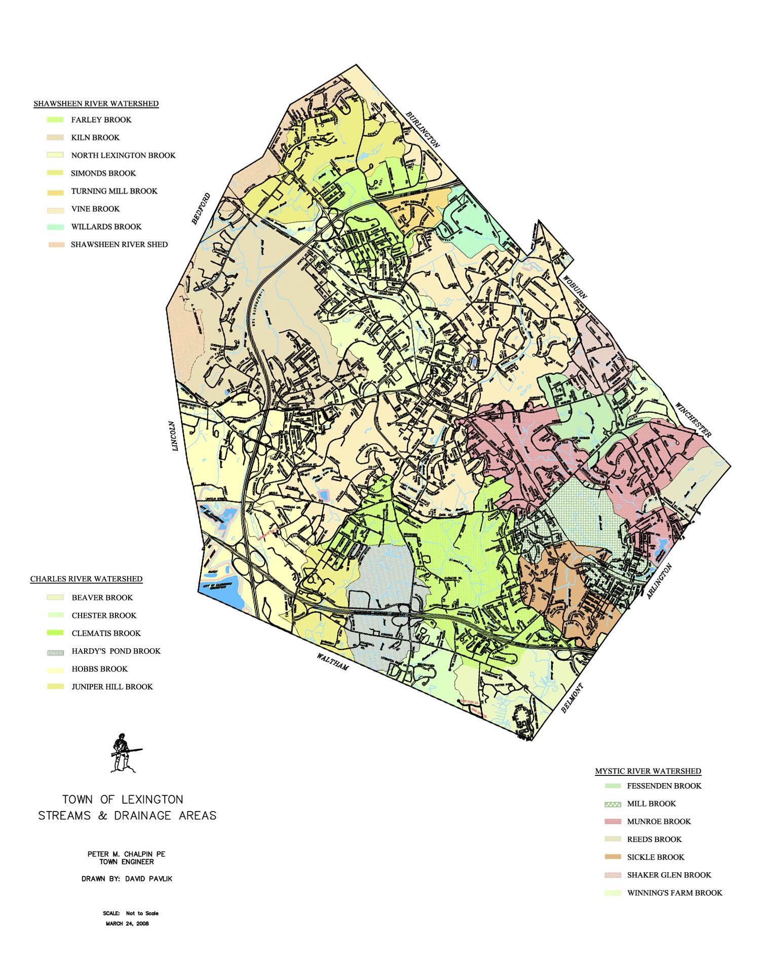
Lexington contains 21 sub-watersheds (also called drainage basins) that drain to three major watersheds, the Shawsheen River Watershed, the Mystic River Watershed, and the Charles River Watershed, which meet on Eliot Road near the Community Center. Major storage basins exist at Tophet Swamp for the Shawsheen River Watershed, Dunback Meadow and the old Metropolitan State Hospital area (and to a lesser degree, parts of Hayden Woods) for the Charles River Watershed, and the Great Meadow and Munroe Meadows for the Mystic River Watershed. The boundaries of major watersheds are shown on MAP 6. Map 6A Subwatersheds depicts the Town’s sub-watersheds and was prepared by David Pavlik of the Town’s Engineering Division in March 2008. Note that the Shawsheen River Watershed is a drainage area without a major stream channel, which accounts for the difference between the Town’s 20 brooks and 21 subwatersheds. Lexington’s sub-watersheds include:
Draining to the Shawsheen River Watershed
• Farley Brook
• Kiln Brook
• North Lexington Brook
• Simonds Brook
• Turning Mill Brook
• Vine Brook
• Willards Brook
• Shawsheen River Shed
Draining to the Mystic River Watershed
• Fessenden Brook
• Mill Brook
• Munroe Brook
• Reeds Brook
• Sickle Brook
• Shaker Glen Brook
• Winning’s Farm Brook
Draining to the Charles River Watershed
• Beaver Brook
• Chester Brook
• Clematis Brook
• Hardy’s Pond Brook
• Hobbs Brook
• Juniper Hill Brook
While Lexington does not have a major river running through its landscape, it does have 20 brooks that play important roles in the infrastructure and character of the town. All of Lexington’s brooks originate within the Town’s boundaries and flow outward to other towns except for a small section of Reeds Brook, making Lexington a headwaters community. Over time, these brooks have been altered by human activity through changes such as channelization, the introduction of culverts, and sedimentation build-up from road sand and other run-off. Furthermore, impervious surfaces such as roads, parking lots, and buildings have caused more stormwater runoff to enter the brooks than would naturally. These impacts have resulted in flooding problems, degradation of water quality, and impacts to habitat in many areas. Lexington’s brooks flow directly into Arlington, Belmont, Waltham, Lincoln, Bedford, Burlington, and Woburn before traveling onward to discharge in the Atlantic Ocean near Boston and Newburyport. The Town’s brooks contribute to water supplies in Burlington via the Vine Brook, Bedford via the Kiln Brook/Shawsheen River, and Woburn via Woburn’s Horn Pond from Shaker Glen Brook, as well as Cambridge via Hobbs Brook and the Cambridge Reservoir. The other two reservoirs in town, the Arlington Reservoir and the Lexington Old Reservoir (or Old Res), are now used for swimming rather than water supply.
In 2007, the Louis Berger Group, Inc. completed a water quality study of the Old Res, which has had problems with high coliform counts after rainstorms. A deepwater well was added in 1982, which serves to maintain the water level but does not guarantee improved water quality. The results of the study show that the major source for bacteria entering the water body is stormwater discharged by the four outfalls along Marrett Road. In addition to providing a popular swimming area in Lexington, the water from the Old Res eventually flows to the Vine Brook and on to the Shawsheen River watershed, so improving water quality is also important to communities downstream. In 2009, Town Meeting appropriated Community Preservation Act (CPA) funding to complete a stormwater management mitigation project at the Old Reservoir which was completed and implemented in 2013.
Other issues with brook health and function in Lexington are being addressed through a Watershed Stewardship Program that started in the fall of 2008. The program, initially coordinated by the Conservation Division, the Engineering Division, and citizen volunteers, including the Lexington Conservation Stewards and students from the Minuteman Career and Technical High School, conducted stream shoreline surveys to identify problems caused by stormwater run-off and impaired outfalls. The data collected in those surveys was processed into map format and used as a planning tool for remediation of identified stream problems. The program is now coordinated solely by the Engineering Division and engages students from the University of Massachusetts Lowell through an internship program.
Efforts to mark storm drains with “Don’t Dump, Drains to Stream” markers began in 2011 and are ongoing, through the Engineering Division in collaboration with the Conservation Stewards.
Lexington’s network of small brooks and the wetlands surrounding them serve as the backbone for the Town’s hydrology, and provide the following functions:
• Brooks provide avenues for stormwater to travel in, acting as efficient conduits for moving water and help to reduce flooding.
• Brooks help maintain a stable groundwater “budget” by transferring excess water during seasonally high groundwater periods, thereby reducing flooding.
• Brooks act to recharge groundwater supplies through infiltration.
• Brooks assist in the maintaining of static water levels in ponds and reservoirs.
Ecologic:
• Brooks assist in filtering out pollutants and sediment, especially by discharging water into surrounding wetlands with filtration capacities.
• Brooks provide prime wildlife habitat, including habitat for several threatened and endangered species.
• Brooks create ecological diversity by helping to maintain the hydric (wet) soil conditions that support important wetland plant communities.
• Brooks provide aesthetic enjoyment for citizens and passive recreation for hikers, fishers, bird watchers, and outdoor enthusiasts.
Brook corridors traverse a large number of Lexington’s conservation areas. Prolific wetland systems surrounded by relatively large tracts of undisturbed land, as well as vegetated areas running along brook channels, provide essential components of wildlife habitat, including: food, cover, water, and nesting and breeding space. Some of the most important brook corridors that currently exist in Lexington include areas along Vine Brook, Simond’s Brook, Munroe Brook, Beaver Brook, and Kiln Brook. Degradation to these natural brook corridors impacts species that travel in them, such as white-tailed deer, coyote, and fisher. For a further discussion of wildlife corridors in Lexington, see the section on Fisheries and Wildlife.

Vernal pools are ephemeral bodies of water that do not support predatory fish and provide essential spring breeding habitat for various amphibian species, including wood frogs and blue-spotted salamanders. Vernal pools are protected by the Massachusetts Wetlands Protection Act, but must be certified as vernal pools before falling under this protection. Twenty-four certified vernal pools are located within the Town of Lexington as of November 2022. The locations of cataloged vernal pools are shown on MAP 7.
The boundaries of the one hundred year floodplain are shown on MAP 6. Floodplain areas in Lexington provide important temporary flood storage capacity when adjacent surface water bodies overflow. These areas frequently contain valuable wildlife habitat including a number of Lexington’s certified vernal pools.
The Commonwealth’s Office of Geographic and Environmental Information (MassGIS) has mapped approximately 519 acres of open marshes/bogs and 750 acres of wooded marshes in Lexington, and more freshwater wetland exist that have not yet been mapped. These freshwater wetlands provide habitat, recharge groundwater, purify water, and store surface runoff, slowing the progress of flood waters. Many of the freshwater marshes in Lexington fall within open space areas, including Tophet Swamp, the Great Meadow, Willard’s Woods, and Dunback Meadow. MassGIS’s mapped wetlands are shown on MAP 6.
The high percentage of impermeable surface in Lexington, both natural and human-made, results in a high rate of precipitation runoff, which reduces the amount of water available for groundwater recharge. Groundwater recharge takes place in wetlands, such as those found in the Upper Vine Brook, Lower Vine Brook, Willard’s Woods, and Dunback Meadow conservation areas. Lexington includes 3,256.7 acres of Kiln Brook photographed in the Meagherville Conservation Area. Department of Environmental Protection Approved Wellhead Protection Areas (Zone II), which are important for protecting the recharge area around public water supply groundwater sources. Most of this acreage falls in the Vine Brook watershed, which provides drinking water for the town of Burlington. These Zone II areas are shown on MAP 6.

Before settlement, Lexington—like much of New England—was almost completely forested. As Lexington’s early settlers cleared land for farming, the Town’s forests were transformed into grassland or cropland, and by the early 1900’s, only 30 percent of the Town was forested. More recently, as farming has given way to other land uses, many of the old fields that remain as open space have transitioned back to forest. Using the Society of American Foresters’ classification system, Lexington’s forests generally fall under the Transition Hardwoods-White Pine-Hemlock and the Central Hardwoods-Hemlock-White Pine forest types.
This zone, which covers much of Worcester and Franklin counties, as well as portions of Berkshire, Hampden, Hampshire and Norfolk counties, is named because both northern hardwoods and central hardwoods such as oaks and hickories mix here. White pine is found on abandoned fields and sandy sites and hemlock/northern hardwood mixtures on lower slopes, with central hardwoods, white birch and white pine on the hilltops.
This zone covers much of eastern Massachusetts, except southern Plymouth County and Cape Cod, as well as lower elevations in southern Worcester and southern Hampden counties. Oaks and hickories dominate, with red maple, chestnut oak, black birch and scarlet oak also common. Hemlock is the most common softwood but white pine predominates on sandy sites.3
It is important to remember that forests are dynamic, changing over time and with varying human and ecological influences, so that these classifications do not necessarily designate the type of forest found now, but rather a classification of forests that would likely have existed, or would be likely to develop, without significant human intervention.
Within these two types, Lexington’s forests vary widely, both due to natural and human influences. Examples of some of the less common forest communities include the patches of scrub oak and pitch pine found at the uplands of the Great Meadow and on top of Whipple Hill, the yellow birch and hemlock forest found at the Paint Mine conservation area, and the stands of American beech found at the Meagherville conservation area and Katahdin Woods.
The age of a forest also plays an important role in determining which plants dominate its canopy and understory. Agricultural land that was abandoned earlier, such as is found in the Sutherland Woods conservation area, supports a more mature forest than agricultural land that was abandoned later, such as is found in the Juniper Hill conservation area. In some places, old agricultural land that was previously drained has reverted back to forested wetland, such as in the lower areas of the Simond’s Brook and Dunback Meadow conservation areas.
Both the older and the younger forests in Lexington provide a scenic quality to the town as well as passive recreation opportunities for walkers, runners, skiers, bird-watches, and other outdoor enthusiasts. Forested areas surrounding the town’s streams help to provide shade cover and soil stabilization to protect stream health. Forested wetlands and uplands provide habitat for a wide variety of plants and wildlife, contributing to the overall biodiversity of the town. Forests also perform a number of other ecosystem services, such as filtering pollutants from air, reducing erosion, and absorbing stormwater runoff.
In addition to Lexington’s forests, open meadows maintained by annual mowing are located on a number of conservation areas (see below—Managed Properties). In other cases, current agricultural activity keeps meadows open, including at Wilson Farms, Waltham Street Farm, and Hayden Woods conservation areas, and Busa Farm. These open meadows provide habitat variety in Lexington and are particularly important for certain butterfly, bird, and small mammal species, as well as hunting coyotes and foxes. Meadows also help to stabilize soil and filter air and water. Without annual mowing, these meadows would revert to forest through the process of succession.
3 Classification of the Natural Communities of Massachusetts, Massachusetts Division of Fisheries and Wildlife: https://www.mass.gov/ doc/classification-of-the-natural-communities-of-massachusetts/download.
Lexington currently has six flora species contained on the National Heritage and Endangered Species Program rare species list. The following table is based on information extracted from the NHESP database.4
Taxonomic Group Scientific Name Common Name MESA Status Most Recent Observation
Vascular Plant Platanthera dilatata Leafy White Orchid T Historic
Vascular Plant Claytonia virginica Narrow-leaved Spring Beauty E 1998
Vascular Plant Mimulus moschatus Muskflower T 1913
Vascular Plant Houstonia longifolia Long-leaved Bluet E 1897
Vascular Plant Doellingeria infirma Cornel-leaved Aster E 1931
Vascular Plant Liatris scariosa var. novae-angliae New England Blazing Star SC 1902
MESA Status Key: E = Endangered T = Threatened SC = Special Concern
As mentioned above, while Lexington’s forests fall into two broad types, on a finer scale, they vary across town depending on topography, age, human impacts, and soils. The town’s meadows show variety as well. Some of the more unusual vegetation features in Lexington are described below.
Whipple Hill is the largest tract of forest in Lexington, with roughly 120 acres of forest. The canopy is dominated by oak, pine, and hickory. The understory includes viburnum, sassafras, and spicebush, with sweet pepperbush growing along Whipple Brook. This woodland and the small pond located within it support abundant wildlife. A small area surrounding the summit has been cleared routinely throughout its history, either from fire or by the ravages of gypsy and brown-tailed moths during the 1890’s. Vegetation found on the top of Whipple Hill, such as scrub oak, pitch pine, and bear-berry, is rare otherwise in town. In 2007, the New England Plant Conservation Program (NEPCoP) conducted rare plant monitoring activities at Whipple Hill and identified 17 plants of Polygonum tenue (Slender Knotweed) and 30 patches of Selanginella rupestris (Rock Spikemoss).
The upland portion of Arlington’s Great Meadow has been repeatedly burned, causing this area to resemble a scrub oak-pitch pine barrens, with lowbush blueberry growing in the poor soils. The wetter portions of Arlington’s Great Meadow contain a wide variety of native wetland plant species, including buttonbush, highbush blueberry, and winterberry, although the invasive purple loosestrife is gaining ground in the wetlands. The vegetation in this area has made it a well-known spot for woodcock breeding.
White pine stand and meadows at Willard’s Woods Conservation Area
The white pine grove at Willard’s Woods is the largest of its kind in Lexington, with some red pines mixed in and young oaks and hickories beginning to fill in the understory. The adjacent meadows are dotted with red cedar and grow high with field annuals by the end of the summer.
Pine plantation and meadow at Dunback Meadow Conservation Area
Dunback Meadow conservation area includes a pine stand that was planted at the turn of the century as a timber source and then later abandoned. During the winter of 1980–1981, 21 long-eared owls roosted within this pine grove, and other owls have been spotted there since. The vegetation in the open meadow attracts a wide variety of bird species and makes Dunback Meadow one of the Town’s most popular birding areas.
Program: https://www.mass.gov/info-details/rare-species-viewer
Within this conservation area is a deep ravine that supports trees that are more commonly found in northern New England, including dense hemlocks and yellow birch. This is also one of the two locations in Lexington where American hop hornbeam is found.
American beech forest at Meagherville Conservation Area
The Meagherville conservation area contains Lexington’s largest forested area dominated by American beech, a tree that is not common as a dominant species in this part of the state. Beech-drops, an uncommon saprophytic plant in Middlesex County, grows on the roots of these Meagherville beeches.
In 2021, Beech Leaf Disease was detected in the Meagherville beech forest. This newly described disease was first identified in 2012 and a means of infection, spread, and symptomatic development has yet to be identified. The disease attacks the leaves, causing damage that first appears as dark stripes on the leaves which later begin to take on a curled, wrinkled, or withered appearance. Infected trees show reduced vigor and can eventually die.5
Lexington manages all of its forested conservation areas for passive recreation and wildlife habitat. No forest in Lexington is currently managed for timber harvesting purposes, due in large part to the relatively small size of forest patches that exist, the lack of nearby sawmills, and the heavy recreational use on the town’s forests.
The Town annually mows the vegetation at some areas of its conservation areas in order to maintain open meadows. Conservation Land with mown areas include Parker Meadow, Wright Farm, Juniper Hill, Cotton Farm/Upper Vine Brook, Paint Mine, Hennessey Field, Poor Farm, West Farm, Chiesa Farm, Daisy Wilson’s Meadow, Idylwilde, Willard’s Woods, and Shaker Glen. In addition, active agricultural practices keep other fields open, both on Town-owned land (Waltham Street Farm, Hayden Woods, and LexFarm/Busa Farm) and privately owned land (Meadow Mist, Wilson Farm). Finally, NSTAR periodically mows the vegetation in its utility easements in order to maintain access, which keeps shrubs, grasses, sedges, and wildflowers dominant in these areas.
The following list describes some of the more prominent open meadows in town.
Poor Farm Conservation Area: A mowed knoll at Poor Farm, bordered by apple and peach trees and with a bench set at the center, provides a lovely open vista from the entrance off Cedar and Hill Streets.
Willard’s Woods Conservation Area: The mowed fields at Willard’s Woods provide habitat for a wide variety of butterfly-attracting wild flowers, including milkweed, goldenrod, sarsaparilla, asters, and thistle, that Lexington schools use as part of their Big Backyard educational program. Several cedars that have grown up in the center of the fields provide cover for birds.
West Farm Conservation Area: The open hillside at West Farm provides what is considered by many to be the loveliest rural view in Lexington.
Daisy Wilson Meadow Conservation Area: The open field at Daisy Wilson Farm, bordered by stonewalls, gives the visitor to this property a sense of the original context for the farmhouse and barn that still stand adjacent to the property.
Idylwilde Conservation Area: The open field that occupies most of Idylwilde conservation area provides an area of open space in an otherwise densely populated neighborhood. Due to slope, position of trees, and rough, rocky landscape, this area is more suited for passive than active recreation. Currently this is the site of the Idylwilde Community Garden.
Chiesa Farm Conservation Area: The hay fields at Chiesa Farm are mowed each year by a hired contractor. This property, seen from Adams Street, competes with West Farm for Lexington’s most attractive rural vista.
5 https://www.mass.gov/guides/beech-leaf-disease-in-massachusetts
Dunback Meadow Conservation Area: Dunback Meadow is the largest conservation property (161 acres) in Lexington and includes an extensive wet meadow, a pine grove, a red maple swamp, Clematis Brook, and a community garden.
Wright Farm: The 12.6 acres Wright Farm was purchased by the Lexington Conservation Commission in 2013, with trail development and land management activities forthcoming. With sweeping historic farm fields and rich forested wetlands, Wright Farm provides key open space and habitat connectivity in the northwest corner of Lexington. The property adjoins the Burlington Landlocked Forest (LLF), a regionally popular 250-acre open space area with a well-developed trail network. Future trail development at Wright Farm will provide access to the Burlington Landlocked Forest. Waltham Street Farm Conservation Area: The field at Waltham Street Farm is utilized for corn crops by the lessee, a long-time Lexington farming family. The field, backed by woods and distant hills, affords a lovely scenic vista during all seasons from Waltham Street.
The Town is looking into applying for the Department of Conservation and Recreation’s (DCR) Forest Stewardship Program. This program provides means to protect woodlands in the Commonwealth through the creation of 10 year forest management plans. These plans are specific to each tract of woodland in an effort to protect soil and water quality, fish and wildlife habitat, timber resources, and continued recreation opportunities.
NSTAR Power Line Easement: NSTAR cuts the vegetation back every five years or so in order to keep the easement open for repair trucks and regular maintenance. NSTAR encourages use of their easements, believing that an actively used property is less prone to vandalism.
The Town of Lexington approved a Tree Bylaw in April of 2001. This bylaw effectively increased the protection of Lexington’s tree canopy. Shortly thereafter, in October of 2001, a Tree Committee was established for the continued protection, care, and planting of trees in Lexington. To that end, the Committee published a Tree Management Manual in 2009. The manual has since been updated periodically, with the 4th and latest edition published in 2020.
The Tree Management Manual is a practical guide to tree planting and care. It is directed toward Town employees, builders, contractors, developers, and private individuals. Topics in the Manual include:
• Tree Planting
• Planting Guidelines
• Maintenance Specifications for Pruning
• Tree Protection During Construction
• Invasive Species—Impact on Public Lands
One of the major goals of the Tree Committee is to replace trees lost during the preceding year on a one to one basis. This is accomplished through on ongoing inventory of trees kept by the Committee and a tree planting program designed to continually replenish the supply of shade trees and to maintain a healthy canopy. In addition to enhancing the aesthetic value of the Town’s streets, schools, parks, open spaces, and private residences, this practice contributes toward mitigating some of the adverse effects of climate change.
In the past, the Department of Public Works in collaboration with the Tree Committee maintained a small tree farm for municipal tree planting within the Lower Vine Brook Conservation Area. This tree farm is no longer active and is currently a native plant nursery overseen by Conservation Stewards.
For many species of wildlife, Lexington represents the easternmost boundary of available habitat in the Greater Boston area. Lexington’s wildlife provides ecological, recreational, educational, and aesthetic benefits to the citizens of an increasingly urbanized section of Massachusetts.
Wildlife corridors connect two or more wildlife habitat areas, allowing animals to travel through otherwise developed areas or un-travelable areas. In densely populated communities such as Lexington, wildlife may use train tracks, rail trails, bike paths, or power lines as corridors as well as streams, rivers, undeveloped wetlands, riparian buffers, and backyards (see MAP 7).
The most significant wildlife corridors that pass through Lexington are: Regional
• The Minuteman Bikeway and Minuteman National Historic Park form the basis for Lexington’s regional habitat links. These links provide access to the west and east toward Concord, Bedford, and Arlington. Local
• The stretch of green space surrounding Munroe Brook, which connects Arlington’s Great Meadow with Arlington Reservoir,
• The stretch of green space from the Old Reservoir to the Lincoln Park wetlands,
• The stretch along a significant portion of Vine Brook from Butterfield’s Pond to Lower Vine Brook Conservation Area,
• Along a significant portion of Simonds Brook and Kiln Brook (in the West Lexington Greenway region, including Meagherville Conservation area and the Pine Meadows Golf Course),
• A significant portion of Clematis Brook from Dunback Meadow Conservation Area to Beaver Brook in Belmont, including the surrounding Hayden Woods and Upper Vine Brook conservation areas.
Land acquisition and protection in strategic locations could create stronger wildlife corridors in certain areas of town, such as along some of Lexington’s brooks, along the West Lexington Greenway project area, and between many conservation areas. For instance, Joyce Miller’s Meadow conservation area, which borders the Minuteman Commuter Bikeway and sits just south of Lower Vine Brook conservation area, was acquired in 1995, increasing the already significant amount of green space along the Bikeway. During the 1970’s and 1980’s, Lexington protected land adjacent to powerline easement through its purchase of the Paint Mine, Simonds Brook, Tophet Swamp, Katahdin Woods, and Cranberry Hill conservation areas. Protecting other areas through similar strategies can build new wildlife corridors and strengthen existing ones.
Efforts toward this end are underway as part of the West Lexington Greenway project, which will link the Minuteman Bikeway with the Battle Road, providing a travel corridor for people and wildlife alike. The addition of Wright Farm has strengthened the connection from the Burlington Landlocked forest.
Migration represents a critical time for the survival of many bird species that pass through Lexington annually. As much as 80-90% of annual mortality may occur during the migratory period.6 “Stop-over” habitats that provide species with food, rest, and a low risk of predation can lower the risk of migration and contribute to the long-term viability of migratory populations.
6 Monitoring Animal Migration in the Greater Acadia Region, Olsen, McCabe et al, University of Maine, 2013
Lexington contains many mammal species that are common to semi-rural areas of eastern Massachusetts. While no formal inventory of mammals has been conducted in Lexington in the recent past, observations as well as information in MassWildlife’s State Mammals List indicate that the following mammals utilize habitat in Lexington: Eastern coyote, red fox, white-tailed deer, beaver, mink, otter, muskrat, ermine, longtailed weasel, fisher, raccoon, skunk, Virginia opossum, gray squirrels, red squirrels, flying squirrels, Eastern chipmunk, woodchuck, Eastern cottontail rabbit, various bats, and various small mammals (shrews, moles, voles, mice, rats). Occasional visitors to Lexington may include porcupine, bobcat, and bear, although no recent sightings have been noted.7
In 1912, Dr. Winsor M. Tyler (contributor to Arthur C. Bent’s Life Histories) compiled a bird list for Lexington that was published as an appendix to Charles Hudson’s History of the Town of Lexington. Tyler’s list included 166 species, 87 of which were breeding in Lexington. A modern list compiled by John Andrews for the Citizens for Lexington Conservation lists 185 species, 69 of which are thought to breed in the Town (See “Checklist of Lexington Birds” by John Andrews). The increase in the total number of species is due primarily to the greater skill and resources of modern birders (armed with excellent field guides, optics, and automobiles) in ferreting out the more rare migrants. The decline in the number of breeding species is probably due to a variety of causes, chief among them being the destruction of wetlands, conversion of farmland to residential use, and the introduction of the European starling and English house sparrow. Lexington contains at least one birding site, Dunback Meadow, that is of statewide significance. It was at this site in 1979 that the first state record of McGillivray’s warbler occurred. Dunback Meadow is also a dependable site for wintering long-eared owls, a rare species in this part of the state. In the winter of 1980–81, a remarkable roost of 22 long-eared owls assembled at Dunback Meadow. Birding groups from three states visited the site to observe the birds and a behavioral study of roosting was conducted. Dunback Meadow is also one of the best sites in the area for observing the courtship displays of the American woodcock, and birders from neighboring towns visit the site yearly to observe this spectacle. Dunback Meadow is the only site in Lexington where the following species are regularly observed: sawwhet owl, northern shrike, bobolink, and the grasshopper sparrow. Each year, several bird walks are held at Dunback Meadow by the Brookline Bird Club and by Citizens for Lexington Conservation. It is also censused yearly as part of the Greater Boston Christmas Bird Count sponsored by the National Audubon Society. Other sites of birding interest are Whipple Hill (spring migration, wood duck, broad-winged hawk), Willard’s Woods (spring migration, breeding broad-winged hawk), Arlington Reservoir (waterfowl, shorebirds, osprey), Hobbs Brook Basin (fall shorebirds), and Arlington’s Great Meadow (ruffed grouse, great horned owl).
While a formal inventory of reptiles and amphibians in Lexington has not been conducted in recent years, observations and MassWildlife’s State Reptiles and Amphibians List indicate that the following species occur or are likely to occur in Lexington.8
Snakes: black racer, common garter, milk, brown, eastern hognose, ribbon, northern water, redbelly, ringneck, and smooth green.
Turtles: snapping, eastern musk, painted, spotted, and box (the last two listed as species of special concern).
Toads: American, Fowler’s.
Frogs: spring peeper, gray tree, bull, green, pickerel, leopard, and wood.
Salamanders: spotted, northern dusky, eastern red-backed, northern two-lined, bluespotted, four-toed, (both species of special concern), marbled (threatened species) and eastern newt.
7 Mammals in Massachusetts, MassWildlife: https://www.mass.gov/service-details/mammals-in-massachusetts
8 Amphibians and Reptiles in Massachusetts, MassWildlife: https://www.mass.gov/service-details/amphibians-and-reptiles-in-massachusetts
The principal site in Lexington frequented by fishers is the Old Reservoir. It is stocked with trout each spring by the Massachusetts Department of Fisheries and Wildlife. Other sites where fishing has occurred, but is not permitted, are Hobbs Brook Basin (Cambridge Water Supply). Fishing at the North Street sand pits is discouraged due to dangerous depths.
The National Heritage and Endangered Species Program, part of the Massachusetts Division of Fisheries and Wildlife, lists observations of 9 endangered, threatened or special concern species in Lexington, as indicated in the table below. As noted in the above inventories, other species may be present but unobserved due to the low level of recent survey efforts.
Taxonomic Group Scientific Name Common Name
MESA Status Most Recent Observation
Amphibian Ambystoma laterale Blue-spotted Salamander SC 2009
Bird Podilymbus podiceps Pied-billed Grebe E 1899 Bird Ixobrychus exilis Least Bittern E Historic Bird Circus cyaneus Northern Harrier T 1879
Bird Tyto alba Barn Owl SC 1956
Crustacean Eubranchipus intricatus Intricate Fairy Shrimp SC 2014
Dragonfly/Damselfly Williamsonia lintneri Ringed Boghaunter T 2013
Reptile Glyptemys insculpta Wood Turtle SC 1994
Reptile Terrapene carolina Eastern Box Turtle SC 1992
MESA Status Key: E = Endangered T = Threatened SC = Special Concern
9 Rare Species Viewer, Massachusetts Natural Heritage & Endangered Species Program: https://www.mass.gov/info-details/rare-species-viewer
The following list presents a brief description of a few of the additional unique landscape features that have not been described elsewhere in this chapter. For a presentation of where these features are in Town, please see MAP 8.
The Lexington Battle Green is the center point of the Town’s historical interpretation efforts. Tourists come by the busload to visit this important historic location, and the nearby Visitors’ Center averages approximately 100,000 visitors each year. Town-sponsored guides give talks on the Battle Green year-round. Guided tours are conducted from April through October by Lexington Historical Society guides at the nearby Buckman Tavern, Hancock-Clarke House (on Hancock Street, about one-third mile away), and at Munroe Tavern (on Massachusetts Avenue, about one mile to the east).
Belfry Hill is an approximately 3 acre site located across the street from Cary Memorial Library, near the Battle Green. During the warmer months, the site provides a venue for the Town Librarian’s story hour, informal exploration, and a wonderful opportunity for employees who work in the Town Center to take a pleasant lunch outside. In winter, it is a popular sledding location and a destination for contemplative strolls. Tourists also ascend the hill throughout the year to see the historic belfry atop.
This Town-owned area is an open, landscaped park along Massachusetts Avenue just outside of the center of town and accessible from the Minuteman Bikeway. Tower Park offers benches, picnic tables, and a pathway for leisure walks, as well as shade trees, rolling lawn, and ornamental shrubs. On fair weather days, dozens of cars are often parked along Massachusetts Avenue along the park with their passengers lounging on the grass, picnicking, or playing informal games. In the winter, children sled from Massachusetts Avenue to the Minuteman Bikeway.
The Minuteman National Historic Park is owned by the United States and administered by the National Park Service. Most of this linear park, stretching along Route 2A from Lexington (west of Route 95/128) to Concord, lies in Lincoln and Concord, but a small portion of the western end of the park lies in Lexington. The Lexington portion of the park contains the Bloody Bluff, the Minute Man Visitor Center, and Fiske Hill. Visitors to this park usually also stop at the Lexington Battle Green and historic houses in Lexington to view the early American Revolutionary Scenes.
In addition to the unique hemlock ravine described in the earlier section on Vegetation and a registered NHESP vernal pool (certification #7259), the Paint Mine area also contains a wetland that was previously flooded to create muskrat breeding habitat and is now slowly reverting back to bog. An open power line easement, pine-oak woods, and adjacent Hennessey field add to the ecological diversity of this area.
Though owned by Arlington, the Great Meadow is located entirely within the bounds of Lexington. Consisting of dry upland areas, extensive wet meadows, and two registered NHESP vernal ponds (certifications #184 and #8220), this 184-acre property makes up one of the largest contiguous open spaces in Lexington. During the late 1800’s, Arlington’s Great Meadow was visited by noted naturalists such as Frank Boles and William Brewster. In his 1893 journal, Brewster described a visit to Great Meadow during which he studied the pied-billed grebes that were common there. Almost 100 years later, pied-billed grebes were spotted at the nearby Arlington Reservoir (which is partly in Lexington). As far back as 1967, the Great Meadow was considered an important link in a greenbelt that connects it with the Mystic Lakes in Arlington. At the conference celebrating the 75th Anniversary of the Metropolitan Park System, Executive Director of the Metropolitan Area Planning Council recommended that “trails could be developed from this center [Mystic Lakes area], around the lakes and along the greenbelt connections to the east of the Middlesex Fells and to the west to Great Meadow in Lexington.”

The Lower Vine Brook property, which contains a former sand pit, displays a dramatic landscape with greatly varied topography. The area includes two registered vernal ponds (certifications #7092 and 8263) where eastern newts, spotted salamanders, northern leopard frogs and fairy shrimp have been known to breed. Vine Brook, which runs along the western side of this property, provides a significant forested wildlife corridors stretching from the Burlington line at Butterfield Pond through the Lower Vine Brook Conservation Area. Lower Vine Brook is also one of the closest conservation areas to the center of Lexington.
The 78.9 acre Hayden Woods Conservation Area features an old Lexington road that was laid out in 1660 and which was, according to local historians, a part of the so called Virginia Path, which led Native Americans to the Shawsheen River where they traded goods with northern tribes.
Most of Cotton Farm/Upper Vine Brook is wetland, but the eastern side of the area is accessible by a trail running from Highland Avenue to a driveway that exits onto Marrett Road. The site has scenic frontage on Marrett Road and hosts a Town-owned apple orchard. There is a small picnic area near the pond at the Marrett Road entrance to Cotton Farm/Upper Vine Brook.
The 12.6 acres Wright Farm, with its sweeping historic farm fields and rich forested wetlands, adds significant value to the Town’s scenic landscape as well as a key wildlife and recreation connection with the Burlington Landlocked Forest.
The community gardens at Idylwilde, which are owned and managed by the Conservation Commission, are considered important resources to the Town; they are extremely popular and highly valued by residents.
The Town acquisition of Busa Farm in 2009 allowed for the preservation of an important agricultural resource in Lexington. Currently the site of Lexington Community Farm, this is one of two Community Supported Agriculture (CSA) programs in Lexington (Wilson Farm also offers a CSA).
The Bloody Bluff, which is located at the historic Fiske Hill site at the corner of Old Massachusetts Avenue and Marrett Road, is considered an unusual geological feature in Town. As described earlier in the landscape characters, it reveals a section of granite bedrock exposed by the Bloody Bluff fault running through Lexington as it travels approximately 80 miles from Newbury, MA to northern Connecticut.10 First discovered in the early 1960’s, the Bloody Bluff fault was seen by geologists as an opportunity to examine the theory of plate tectonics, as hypothetically the Bloody Bluff area was an area of contact between two major continental plates.
The rounded summit rock and high exposed cliffs of Whipple Hill are also considered unusual geological features. As the highest point in Lexington at 374 feet, the top of Whipple Hill is home to plants not otherwise found widely in Lexington. Owned by the Town as a conservation area, Whipple Hill also hosts a variety of wildlife habitats and a diverse plant species.
As of November 14, 2022, the Massachusetts Department of Environmental Protection (DEP) website listed 247 confirmed hazardous waste sites in Lexington.11 Lexington has no Federal Superfund sites. Most of the state-listed sites are relatively minor oil releases that have been or will soon be cleaned up. However, several other sites listed as reportable releases by DEP are currently listed as open sites at various phases of assessment and remediation.
The Town of Lexington owns a 67-acre parcel situated between Hartwell Avenue and Route 128/95. Approximately one-third of this property previously served as the Town’s landfill. A large portion of the remaining site area is wetlands. The landfill has been closed since 1980 and the Town has used the site for various activities since that time including leaf and yard waste composting, material storage for Department of Public Works (DPW) operations and a regional household hazardous waste collection facility. The site is commonly referred to as either the Hartwell Avenue Landfill or the Lexington Compost Facility (hereafter referred to in this report as the Hartwell Avenue Landfill Site or Landfill Site).
The 38.30 acre Lincoln Park, centrally located in the Town on Lincoln Street, is built on the site of a former landfill. The property was first obtained by the Town as part of the water supply works in the late 1800’s. It was abandoned around 1905 when the Town joined the Metropolitan District Commission and in the 1930’s became the town landfill. In 1963, the landfill was abandoned and subsequently capped. Between 1968 and 1989, various improvements had occurred on the capped landfill to create three natural grass multipurpose fields, a Little League field, and a softball field. The multipurpose fields were further upgraded with synthetic turf in 2003. Today, Lincoln Park consists of three multi-purpose synthetic turf fields, which were resurfaced between 2015 and 2016, one Little League baseball field, one softball field, a seasonal restroom facility, a playground, open space, and the Teresa and Roberta Lee Fitness and Nature Path that are frequented by Town residents and many other organized programs throughout the Town.
Lexington’s land use pattern is basically established and land use issues mainly linger on uses involving redevelopment and intensification. Particularly in Lexington Center, intensification of existing uses is possible within the limits of zoning. A limited amount of further commercial development is possible in outlying commercial areas, with potentially more development upon alteration of dimensional rules. Future commercial development will likely bring with them environmental concerns such as trash, litter, and increased stormwater runoff. Additional efforts on managing stormwater runoff pollution, sedimentation, and erosion into surface waters are necessary, and the Town is taking a variety of steps to address this issue.
On the other hand, only a limited amount of undeveloped land remains in the Town where new development, especially residential, may occur in the future. This development trend could potentially threaten parcels the Town prefers to preserve for open space, but could also create new demand for recreation opportunities. While the Town strives to preserve as much of these undeveloped parcels as possible for open space protection, incentives to encourage appropriate developments that incorporate open space and recreational amenities should continue to be addressed in the project review process.
The Town of Lexington manages stormwater through municipal separate storm sewer systems (MS4s) that are responsible for carrying excess rainwater and snowmelt to local water bodies during precipitation events. MS4 discharges are regulated under the Clean Water Act and a permit is required, along with a written municipal Stormwater Management Program (SWMP) Plan. The SWMP Plan in Lexington was last updated in 2022. In addition to cataloging the MS4 outfalls and impaired waters in Town, the Plan also 11 Massachusetts Energy and Environmental Affairs, Waste Sites and Reportable Releases Online Data Viewer: https://eeaonline.eea. state.ma.us/portal#!/search/wastesite/results?TownName=LEXINGTON
includes details about protocols and procedures related to stormwater testing and management, and describes goals related to stormwater including public outreach/education, maintenance, illicit discharge detection, etc.12
Over the years, Lexington has taken a proactive approach to alleviate flooding. Vine Brook was lowered during the 1950’s, and other brooks were lowered during the 1970’s including: Clematis Brook, Hardy’s Pond Brook, and Willard’s Brook.
A flood control project was completed at the Harrington School site in 2021, in collaboration with the Town of Reading and City of Woburn. The project, which focused on reducing flood discharge to the upper Mystic River, affected a drainage area of 33 acres and resulted in a 27.5% reduction in flow and a 44% reduction in floodwater volume. Cobenefits included improvements to the path network, school infrastructure, and the removal of invasive plants.13
Currently, trouble areas related to flooding include the stretch along Hartwell Avenue, where beavers have erected a dam in Tophet Swamp, the Sickle Brook area between the Waldorf School and the Minuteman Bikeway, the Swommon Land area off Barberry Road, and Kiln Brook at Pine Meadows Golf Club.
Over the past thirty years, Lexington has been dealing with the build-up of sedimentation in its brooks, particularly where they pass beneath roads. In the 1970’s, the Conservation Commission purchased the Parker Meadow Conservation Area and built a pond to slow down the waters of North Lexington Brook, which was causing problems where it passed beneath Route 128. Comprehensive Watershed Management Plans were completed by consultants to the Town Engineering Division, in collaboration with the Conservation Division, for each of the three watersheds: Charles, Shawsheen and Mystic with the goal of identifying land addressing sedimentation issues and improving the ecological integrity of the brooks.
In addition to sedimentation, most of the water bodies and brooks in Lexington face the threat of nonpoint pollution from roadway, house, business, and stormwater runoff, as mentioned earlier in the chapter in Water Resources. Nonpoint pollution is not traceable to a specific structure, such as pollution that travels through runoff or sheets of rainwater across the land. There is no perceivable source of pollution to the groundwater. The Town’s Watershed Stewardship program, coordinated by the Town’s Engineering Division, aims to identify where these nonpoint pollution problems are occurring and plan for remediation efforts. The earlier section covering Water Resources discusses in more detail the water resource protection needs in Lexington.
A number of invasive species are widespread in Lexington. These include trees (Norway maple, tree of heaven), shrubs (burning bush, barberry species), vines that kill trees (oriental bittersweet, English ivy), and herbaceous species (purple loosestrife, garlic mustard, common reed). These invasive species can crowd out native plants, overgrow trails, trees, and utility lines, and impact ecosystem functions. A list of prevalent invasive species in Lexington is included below:
• Acer platanoides - Norway Maple
• Acer pseudoplatanus - Sycamore Maple
• Ailanthus altissima - Tree of Heaven
• Alliaria petiolata - Garlic Mustard
• Ampelopsis brevipedunculata - Porcelainberry
• Berberis thunbergii - Japanese Barberry
• Berberis vulgaris - Common or European Barberry
12 2022 Stormwater Management Program Plan, Town of Lexington: https://www.lexingtonma.gov/DocumentCenter/ View/4974/1_2022-Lexington-SWMP
13 Case Study Report on the Upper Mystic River Flood Control Projects: https://www.mass.gov/doc/case-study-48/download
• Celastrus orbiculatus - Oriental Bittersweet
• Cynanchum louiseae - Black Swallow-wort
• Elaeagnus umbellalata - Autumn Olive
• Euonymus alatus - Burning Bush
• Hedera helix* - English Ivy
• Ligustrum obtusifolium - Border Privet
• Lonicera sp. - All shrub species of Honeysuckles
• Lythrum salicaria - Purple Loosestrife
• Phragmites australis - Common Reed
• Pyrus calleryana* - Callery or Bradford Pear
• Fallopia japonica or Polygonum cuspidatum - Japanese Knotweed
• Rhamnus cathartica - Common Buckthorn
• Rhamnus frangula - Glossy Buckthorn
• Rosa multiflora - Multiflora Rose
• Vinca minor - Dwarf Periwinkle
(Species noted with an * are not included on the Massachusetts Prohibited Plant List but are considered to be prevalent and of concern in Lexington by the Invasive Plant Atlas of New England (IPANE).)
Many groups in Lexington have worked to address invasive species, including the Tree Committee, Lexington Conservation Commission, Lexington Conservation Stewards, Citizens for Lexington Conservation, and the Lincoln Park Sub-Committee. Lexington Conservation Stewards serves as a volunteer organization of Lexington’s Conservation Commission, working closely to plan and carry out stewardship activities on Town-owned conservation land. The Stewards work to control invasive species by eliminating them where possible and limiting their expansion where elimination is impractical. Further coordinated, ongoing efforts and strategic planning are needed to best address this problem.
In 2010, representatives of Citizens for Lexington Conservation, the Lexington Tree Committee, and the Lexington Conservation Commission published a comprehensive Plant Materials Guide for Lexington MA. This guide provides a list of native plant species predominantly native to Middlesex County suitable for landscaping purposes as well as a list of the most common invasive plant species found in the Lexington community. The guide can be downloaded from a link on the conservation web page or copies are available in the Conservation Office and the Cary Memorial Library.
With climate change, new environmental challenges may arise or current challenges may be exacerbated. Climate researchers generally agree that climate change will increase the regularity of extreme weather events, including more frequent extreme storms that may lead to flooding, erosion and destabilization, ice storms and high wind events, which can cause severe damage to forests and other natural landscapes. Rain events that cause overtopping of drainage infrastructure and intense runoff may increase pollutant loads in water bodies and impact open space and habitat. Extreme temperature events on both ends of the temperature spectrum, longer periods of drought, and an overall increase in the average temperature may affect the survival capabilities of native species. Similarly, a change in average temperatures may expand the range of other species and introduce new potentially invasive species into Lexington.14
The recreation potential of open space may also be impacted by climate change. Flooding and other extreme weather events could result in damage to recreation areas and infrastructure. Athletic fields are especially impacted by precipitation at both ends of the spectrum: drought and heavy rains, which can both cause loss of grass cover. Climate change and increases in precipitation may negatively impact the use of open spaces for both active and passive recreation.
During the 2022 OSRP Update process, the role of open space areas in climate mitigation efforts was identified as a potential area of interest. The Commonwealth of Massachusetts is preparing an update to the State Hazard Mitigation and Climate Adaptation Plan (SHMCAP), expected to be published in Fall 2023.
14 Massachusetts Integrated State Hazard Mitigation and Climate Adaptation Plan, Massachusetts Executive Office of Energy and Environmental Affairs: https://www.mass.gov/files/documents/2018/10/26/SHMCAP-September2018-Full-Plan-web.pdf
The SHMCAP reviews anticipated challenges due to climate change and informs the development of State climate mitigation strategies for the next five years. The Town will align with the best practices established by the updated SHMCAP regarding the use of open space in climate hazard mitigation.
Over the years, the Conservation Commission has acquired and protected a number of Lexington’s agricultural properties, including Chiesa Farm, West Farm, Poor Farm, Hennessey Field, Cotton Farm, Wright Farm, and Waltham Street Farm. Some of these areas are now maintained as open meadows, while others are actively used for agricultural purposes.
Lexington is advancing community agriculture through community gardening and community supported agriculture (CSA). Community gardens currently sit on Town conservation land at Idylwilde. The Town purchased Busa Farm, one of the last working farms in Lexington, on December 2, 2009. After lengthy public deliberation the Town has elected to lease the property to Lexington Community Farm, a local non-profit organization that has established a community based farm offering locally grown produce through CSA shares and an onsite farm stand, along with various educational programs for the community. LexFarm opened in 2014 and is currently connected to over 400 member households in Town.
The Town is looking for opportunities to expand community agriculture as interest in locally-grown food continues to trend upwards, both within Lexington and statewide.
As mentioned earlier, the Town has completed a stormwater management mitigation project at the Old Reservoir, using CPA funding. Additionally, the Town has had watershed management plans for Lexington’s three major watersheds completed since 2009. As a result of the watershed management planning, restoring the native buffer zone along the pond at Willard’s Woods and daylighting Willard’s Brook were previously identified as priority projects due to severe erosion from collapsed infrastructure. The daylighting of Willard’s Brook was completed in 2015 and involved the removal of 250 feet of culvert and the addition of access over the brook in the form of two steel truss bridges. Other stream daylighting and restoration projects completed since the publication of the 2015 OSRP include daylighting and restoring Reed’s Brook at the Whipple Hill Conservation Area and daylighting the piped Kiln Brook at Constitution Road, upstream of the Pine Meadows Golf Course.
The DPW and Conservation Division also collaborated on the stabilization of a section of embankment along Vine Brook, which had begun to fail due to erosion. The project involved dredging over 60 cubic yards of the unstable material and reconstructing the embankment with stabilized riprap, clean fill, and erosion control material. Native plants were also introduced to further stabilize and re-vegetate the area.
Equal distribution of Town services is vital to the success and health of the community. Ensuring equal access for all Town residents includes not only access to schools, health facilities, and safety services but also access to public lands and natural areas. Proximity to preserved natural spaces has been shown to increase physiological, psychological, and sociological well-being. These are benefits all Lexington residents should enjoy. Further, it is important to ensure that no part of the population is disproportionately exposed to environments with health hazards or concerns. The issue of environmental equity informs Lexington’s decisions on open space planning as is evident by the well-distributed open space and recreation facilities throughout the Town (see MAP 9 in Chapter 5: Open Space and Recreation Inventory).
Particular attention is paid to the Environmental Justice (EJ) populations, which throughout the Commonwealth are often identified to have suffered from environmental inequality. There are nine environmental justice populations in Lexington, identified as census blocks where either minority or foreign born populations exceed 25 percent of the total block group population, as discussed in Chapters 2 and 3. It is evident, as shown in MAP 2 in Chapter 3: Community Setting, that all of Lexington’s EJ populations are well served by abundant open space and recreation areas distributed evenly throughout the community
and within these EJ neighborhoods. There is no major discrepancy in Lexington between open space availability within and outside of these designated EJ neighborhoods. However, in approaching the next seven years of open space and recreation planning from a lens of diversity, equity, and inclusion, the Town needs to consider whether access to opportunities, programming, and amenities are equally available throughout Lexington. Currently, the processes used to locate programming opportunities such as after-school programs and amenities such as universal access trails at existing open space areas are informal and decentralized. The Town is open to exploring options to integrate environmental equity into the planning process for future activities and new amenities, which may include standardization between organizations at the program development stage and maintaining a graphic inventory of past opportunity locations in order to thoughtfully locate future opportunities. In addition, the Town will incorporate enhanced outreach efforts in EJ neighborhoods to encourage public involvement in open space planning process and promote awareness of available open space and recreation opportunities.
This section details information about open space and recreational lands in the Town of Lexington. According to the Massachusetts’ Executive Office of Energy and Environmental Affairs, open space is: “conservation land, recreation land, agricultural land, corridor parks and amenities such as small parks, green buffers along roadways or any open area that is owned by an agency or organization dedicated to conservation.” The inventory provided here includes conservation and recreation land owned by the Town of Lexington, large tracts of private land, land that falls under Chapter 61, large state-owned properties, and National Park Service land. Additionally, land owned by the Town of Arlington (the Great Meadow) and the City of Cambridge (Cambridge Reservoir) has also been included. Determinations of each site’s condition, recreational potential, and public access were made based on observations by Town staff.
Preservation of open space is extremely important to the residents of Lexington, the region, and the Commonwealth from several different perspectives. Locally, Lexington places a great deal of value in its historic and cultural resources, particularly in regards to the Town’s significance in the American Revolution. A number of these historic and cultural sites also serve as important open spaces, including the Battle Green and the National Park Service’s Minuteman National Historic Park.
Additional land is owned and protected in Lexington by abutting communities, including the Town of Arlington (Great Meadow), which was originally preserved as a reservoir site, and the City of Cambridge (Cambridge Reservoir), which owns hundreds of acres of land in Lexington, Lincoln, Waltham, and Weston.
Much of the land listed in this inventory provides extensive passive and active recreational opportunities. There are a number of existing open space and trail networks among the preserved parcels, and with careful planning and additional acquisition, these networks can be further enhanced. The Greenways Corridor Committee oversee the creation and maintenance of the ACROSS Lexington (“Accessing Conservation land Recreation areas Open spaces Schools and Streets”) trail network, which develops and marks pedestrian and bicycle trails connecting open space areas using new and existing trails and on-street sections. Currently, the network is established between most open space areas east of Route 95/128 and north of Route 2. The network is being continually expanded to reach additional neighborhoods and open space areas, and universally accessible sections are being introduced.
Significant environmental challenges will need to be met in establishing portions of this trail network as portions of the area are subject to protection pursuant to the Massachusetts Wetlands Protection Act and Lexington Wetlands Protection Code. Further, a majority of the area between Bedford Street and Wood Street falls within FEMA-mapped Zone A floodplain areas. Note that within this study area, the Town landfill is located between Tophet Swamp and Katahdin Woods. The landfill is now capped and currently serves as a compost facility, solar farm, and recycling transfer station. Although the landfill cannot be considered an open space at
this point in time, it may play an important role in connecting these open spaces at some point in the future. Furthermore, the Town will continue its efforts to determine where conservation restrictions may be appropriate to further protect valued open spaces in the Greenway area.
The Lexington Inventory of Public and Private Open Space presented at the end of this chapter includes public and private recreation and conservation land. The information contained in the inventory is based on information in the 2009-2015 Open Space and Recreation Plans, survey work of open spaces and recreational facilities by staff at the Conservation Division and Recreation & Community Programs Department, and Assessor’s data updated through fiscal year 2022.
The Open Space Matrix can be found at the end of this chapter. The column headings are defined below.
Name/Location/Map/Lot Names the open space site and identifies the map and lot numbers on the Town assessor’s maps.
Acres Gives the site’s acreage or an approximation in cases where specific information was not attainable. One acre is 43,560 square feet or 1/640 of a square mile.
Ownership/Management Indicates the owner of the property and the agency or department responsible for managing and maintaining the parcel. Usually the two are the same.
Current Use Details the main uses for the site.
Condition Identifies the site condition (excellent, good, fair or poor). Town-owned open spaces and parks were surveyed to obtain a general sense of the condition of the property and any facilities located on it (parking, fields, playground equipment, etc.).
Public Access Indicates if the public can access the site. “LIMITED” denotes sites where public access is restricted or controlled. ”FEE” denotes sites that require payment or membership for public access.
ADA Accessible Indicates if people with disabilities can access the site or its amenities.
Recreation Potential For land not used for recreational purposes, potential for recreational activities is identified. Conservation land is generally deemed to have limited recreation potential except for passive recreation such as hiking and walking. Cemeteries and other similar lands are presumed to have no recreational potential.
Zoning Identifies the zoning district in which the parcel is located.
Protection Status/Deed Restrictions
Indicates if the site, either by virtue of its zoning, ownership, existence of deed restrictions, or by the fact that it has received state or federal funding, is protected against conversion to some other use (see below).
Grant Received Where applicable, identifies the source of funding for the acquisition of the parcel, including public grants, private donations, deed restrictions, etc.
The inventory shows approximately 2,112 acres of Town-owned conservation and recreation land. About an additional 148 acres of recreational land is privately held, including the Hayden Recreation Centre, Lexington Golf Club, and Stone Meadow Golf. Additional properties of privately-owned open space represent approximately 204 acres. There are also two privately-owned properties that fall under Chapter 61A, totaling approximately 18 acres. In addition, there are six properties that fall under Chapter 61B recreational land, totaling approximately 188 acres.
All properties identified in the inventory are depicted in MAP 9.
Determining where the open space and recreation land is located in Lexington is the beginning stage of fully understanding what resources the Town has and where they are located. Once this land has been identified, it is important to ensure its protection and maintenance into the future to help guarantee that many more generations of residents can enjoy them. According to the Massachusetts Division of Conservation Services, land within a community is protected in perpetuity if it is owned by the local
Conservation Commission, by Executive Office of Energy and Environmental Affairs (EOEEA) agencies, by a nonprofit land trust, or if the Town received state or federal monies for the improvement or purchase of the land. Private property can also be permanently protected if there is a deed restriction, if the land is listed as having an Agricultural Preservation Restriction, or if the Department of Environmental Protection (DEP) has placed a restriction on the property for wetland conservation. Typically, land owned by other agencies like the Recreation Committee and the local school system should not be presumed to be permanently protected.
The table below defines the different types of protection that either are or could be available to open space and recreation land in Lexington.
Massachusetts Local Acquisitions for Natural Diversity (LAND) program Massachusetts Parkland Acquisitions & Renovations for Communities (PARC) program
Massachusetts Land and Water Fund
Article 97 Protection
Parcels purchased with funding from these three grants (all administered through the State’s Executive Office of Energy and Environmental Affairs), gain protection in perpetuity by automatically falling under Article 97 (see below).
Protection through Ownership (“Fee”)
Article 97 of the Massachusetts Constitution protects all publicly owned lands used for conservation or recreation purposes. This amendment requires action by the Conservation Commission and Recreation Commission, a 2/3 vote of the Town Meeting, as well as a roll-call 2/3 vote of the State House of Representatives and Senate, in order to sell, transfer, or convert Article 97 lands to a different use. Because the chance of this happening is so small, Article 97 lands are considered to be protected in perpetuity.
In some cases, the open space in question has been acquired in its entirety (“in fee”) by a public or private conservation interest or a State or Federal agency (such as the National Park Service). In many cases, such ownership will trigger other forms of protection, such as Article 97. If the owner is a nonprofit organization (such as the Trustees of Reservations), the land could in theory be sold and/or developed, depending on its restriction status, but doing so could contradict the group’s conservation purpose.
Protection through Conservation Restrictions, Easements, or other Deed Instruments
Due to the high costs of acquiring land, it has become increasingly popular to acquire conservation restrictions limiting future development. Similarly, access easements can provide permanent public access to a property. In certain situations, deed restrictions or easements may be granted by a private party as part of a development approval process. As with any matters involving real property, care must be taken in the drafting of the restrictions to ensure that the rights and interests of all parties are represented and clearly documented. Conservation restrictions must be approved by the municipality and the Massachusetts Division of Conservation Services.
Chapter 61
This program, through reduced property tax incentives, can help protect forest (Chapter 61), agricultural (Chapter 61A), and recreation (Chapter 61B) land in Massachusetts if the land is managed for those purposes. Should the owner wish to end the agreement, the municipality has the authority to recover tax benefits given and has first right of refusal for one year on the purchase of the land if it is to be sold for non-Chapter 61 purposes.
During the update process for this Plan, a GIS analysis was conducted to determine the amount of Lexington’s open space that is protected in perpetuity. The data for this analysis was provided by the Commonwealth of Massachusetts via the Office of Geographic and Environmental Information (MassGIS). The analysis results show that approximately 20% of the total acreage in Lexington is protected in perpetuity as open space.
As part of the 2015 OSRP, the Town of Lexington conducted an ADA Self-Assessment and Inventory of sites managed by the Conservation Division. This assessment was released with the 2015 OSRP as an appendix. Concurrently, the Town of Lexington completed a more detailed study of existing conditions and proposed opportunities to enhance accessibility at these sites; this report was released shortly after the completion of the 2015 OSRP. Both of these efforts, as well as additional self-assessments performed during the 2022 OSRP Update process, inform the updated ADA Self-Assessment for Conservation and Recreation parcels included in Appendix A.
In the Commonwealth of Massachusetts, design standards set by both the ADA (Americans with Disabilities Act) and the MAAB (Massachusetts Architectural Access Board) apply to new construction projects and any renovations to public buildings or facilities. In instances where the two standards disagree, the stricter standard applies. In addition, Federal lands or properties developed by Federal agencies are subject to Architectural Barriers Act (ABA) standards. The ABA standards may be stricter than the ADA standards in some areas; most notably, the ABA contains a subsection governing Outdoor Developed Areas which is not present in the ADA. In Lexington, 249 acres of open space are Federally-owned and operated and are subject to ABA review, with the exception of facilities for military usage without public access.
Though any public buildings at open space areas are subject to the full scope of ADA/MAAB standards, unlike the ABA, neither set of standards contains specific requirements for outdoor open space, though particular recreational elements may be subject to specific requirements. Playgrounds, for example, must comply with a set of unique standards and at picnic areas, a minimum number of picnic tables should be designated universally accessible. All public outdoor spaces must comply with standards governing the path of travel, including slope and width, clearance and planarity of constructed pathways, and dimensions of stairs and ramps. At least one accessible public route is required to reach each element from an accessible point of entry. The ADA and MAAB also provide standards for signage and wayfinding. At sites where parking is provided, requirements for handicapped parking capacity and accessibility apply.
Enhancing Universal Access was a goal within the 2015 OSRP and remains a priority for the Conservation Division and Recreation & Community Programs Department, as well as within the Town of Lexington overall. As a component of that year’s plan, an ADA self-assessment was completed at public parks and Town-owned facilities. In 2017, the Recreation & Community Programs Department completed the more extensive ADA Study of Recreation facilities, focusing on developing recommendations for future improvements. As a part of the 2022 update, the ADA self-assessment was updated at all sites with a particular focus on studying Conservation lands with a similar level of detail.
Since the adoption of the 2015 OSRP, the Town has made advancements towards the design, engineering, and/or construction of universal access trails at multiple open space areas and implementation efforts continue through current day capital planning. The following properties have been renovated to meet ADA requirements in connection with OSRP goals and objectives.
Center Recreation Complex: In 2019, the Center Recreation Complex was renovated for accessibility, a process which involved reconstructing pathways throughout the site for connectivity and ADA compliance.
Cotton Farm: The Conservation Division received CPA funding to complete universally accessible parking and trail improvements to Cotton Farm between 2019 and 2020.
Lexington Community Center: Accessible basketball hoops and renovated ADA pathways were installed at the Community Center building and sport courts.
Parker Meadow: In 2015, CPA funds were first approved to develop plans to construct a universally accessible trail system at this area. The trail was completed in 2022 and features accessible parking and an observation platform with an interpretive wayside panel.
Town Pool: An accessible family changing room and zero-entry wading pool have been added to the Town Pool facility. In 2020, two new accessible lifts were installed to provide ADA-compliant access to the pool.
Willard’s Woods: The Conservation Division has received CPA funding for the design and engineering of universally accessible parking and trail improvements to Willard’s Woods. In addition, accessible pathways have been installed at Sutherland Park, Marvin Park, and Adams Park, poured-in-place surfacing was installed for enhanced access at playgrounds at Sutherland Park and Rindge Park, and an ADA bleacher system was an accepted donation for fields at Lincoln Park and the Center Recreation Complex.
The Town of Lexington recognizes that the ADA and MAAB standards are an essential tool in expanding access at public facilities, but also that both standards have limitations. With the 2022 OSRP update, the Town is now seeking to widen the range of disability considered during construction and renovation projects to provide access for individuals identifying with any type of disability, in addition to providing access to people with physical disabilities. This transition comes as part of a broader effort to increase open space equity for all residents, expanding access to areas and facilities regardless of ability, background, age, identity, language and culture, etc.
Identification and consideration of Lexington’s Environmental Justice (EJ) populations is a vital component of the 2022 Plan’s equity and inclusion focus. According to the 2020 Environmental Justice Population data provided by MassGIS, 9 census block groups out of a total of 22 census block groups in Lexington were identified as EJ populations. EJ populations are designated where either minority or foreign born populations make up an excess of 25 percent of the total block group population. The table below describes the census blocks identified as EJ populations. The block group number in the leftmost column correlates to the label shown on MAP 10 on the following page.
Block Group Total Population Total Households Percent Minority Population Percent Limited English Speaking Median Household Income EJ Criteria Met
1 2,243 799 45.1% 1.0% $194,625 Minority 2 988 369 47.1% 0.0% $219,196 Minority 3 1,340 435 41.3% 0.0% $250,000 Minority 4 2,520 863 43.7% 4.2% $191,131 Minority 5 1,206 390 42.3% 8.7% $148,500 Minority 6 3,558 1,534 42.9% 4.8% $142,125 Minority
7 2,264 721 53.3% 2.8% $195,469 Minority 8 1,664 601 44.5% 10.1% $163,542 Minority 9 1,063 368 46.1% 0.0% $158,889 Minority
MAP 2 depicts the EJ populations found in Lexington based upon MassGIS data. The map also shows the proximity of the Town’s open space resources. The EJ populations are both located in areas of Lexington that seem well-served with access to a variety of open space resources. The western EJ population sector is located within the West Lexington Greenway project study area. One of the goals of the West Lexington Greenway Plan is to create a connected network of trails for walking and biking, which will further enhance connectivity to that area and other portions of the Town. As is the case with the Town as a whole, many of the major recreational facilities and opportunities are located closer to the center of Lexington, so in that respect, the EJ populations are not necessarily more disadvantaged than the population as a whole.
Given Lexington’s growth pattern, it does not have vacant lots that can be easily transformed into parks or open spaces. Rather, the Town hopes to be able to purchase lands of significance as they become available and when the funding exists for such purchases. Criteria will be developed to help guide the acquisition strategy for the Town.
Size (acres)
Protected
RO
Protected
RO
Perpetuity
No
Town-Owned (Other Municipality)
Yes
No
Yes
Conservation
Conservation
Town of Arlington
Town of Arlington
183.00
14.37
Public Lands
Arlington Great Meadow Map: 30 | Lot: 114
Arlington Resevoir Map: 20 | Lot: 37
RO
No
No
Yes
No
Yes
Watershed Protection
City of Cambridge/ Water Department
Conservation
Town of Arlington
151.24
2.36
acres 351
RS Total Town-Owned DRAFT
Cambridge Reservoir Map: 26, 27, 35, 43 | Lot: Many
Size (acres)
Research Center No
Historic RO
DRAFT
USA/National Park Service GC
100.12 Yes
Minuteman National Historic Park Map: 51, 52, 60 | Lot: Many GC/RO Perpetuity
US Postal Service Map: 48 | Lot: 168A 0.45 USA/US Postal Service Post Office
Westview Lot Map: 85 | Lot: 7 0.53 USA Unknown No
Total Federally-Owned acres Total Public Open Space acres 2,873 249
Size (acres)
RS
Swimming
Recreation
Peacock Farm Association
6.93
Peacock Farm Association Map: 7 | Lot: 90, 91B, 92A
Limited
Boston Edison/NSTAR Utility
Chapter 61B Powerline (Katahdin Woods) Map: 66 | Lot: 67
RO Scottish Rites Natural Heritage Museum
4.00
RS
Cultural
9.90 SCOTTISH RITE MASONIC MUSEUM & LIBRARY
10.40 Map: 31 | Lot: 63C&F, 64A
Cultural
RS 0.50 TR SUP COUNCIL A A SR
No
RO
No
Agriculture
John Sellars
0.29
Sellars Lot Map: 10 | Lot: 8
Golf
RS
RO
Fee
Recreation
John Carroll
Chapter 61A Stone Meadow Golf Map: 16 | Lot: 9
21.60
Sun Valley Assoc. Inc. Recreation
Chapter 61B Sun Valley OS Map: 37 | Lot: 92
No
No
Limited
5.00
Agriculture
Wilson Farm, Inc.
Boston Edison/NSTAR Utility
34.82
RO Wilson Farm Map: 14, 21, 22 | Lot: Many
5.48
Wood Street Map: 51 | Lot: 84 Map: 59 | Lot: 43, 66
Young St Inholding
Inholding
RO 2
1.33 STACCHI JAMES V & OBRIEN JULIA
4.48 Map: 54 | Lot: 15-17
RO
RO
HOMES DEVELOPMENT CORP Inholding
Inholding
RO 1.15 DESIMONE RAYMOND &
Unknown
178 LOWELL STREET LLC
8.19
Misc. Open Space Map: 37 | Lot: 11A
Unknown
CARROLL R PATRICK &
0.19
Unknown
GOSTANIAN HERBERT A &
RS Misc. Open Space Map: 21 | Lot: 111
0.36
Unknown
HUANG BERNARD L TRUSTEE
RS Misc. Open Space Map: 38 | Lot: 103B
RS
Unknown DRAFT
1.44
Unknown
MCLAUGHLIN FRANK P
RO Misc. Open Space Map: 21 | Lot: 41
KOZIN SIMON THOMPSON JULIA
0.13
0.29
RS Misc. Open Space Map: 21 | Lot: 32
Public opinion is a foundational tenet for community planning. The OSRP update provided multiple community engagement methods to help guide the Lexington community’s overall open space and recreation goals. Specifically, meetings were held with various boards and committees (Commission on Disability, Community Preservation Committee, Conservation Commission, and Recreation Committee), a virtual public meeting was held to gather general community feedback, and a statistically-valid community survey was developed and deployed to gather representative feedback from the Lexington populace.
The Lexington Commission on Disability (COD) provides research on local problems, recommendations regarding Town policies and services, assistance with ensuring legal compliance, information and referral services, and programs. The Commission met with the OSRP planning team on Tuesday, August 16, 2022 via Zoom. After a brief presentation of the OSRP update process, and summary of the 2015 OSRP, COD members were asked to respond to four questions:
1. What does the definition of disability mean to you?
2. Given your definition, what does it mean for parks, trails, facilities, and open space to reduce barriers and promote use for people with disabilities?
3. Goal #3 in the 2015 OSRP stated, “Promote public use of recreational facilities and open space among a wide variety of user types.” Specifically, there was an objective to provide increased access to programs and facilities for residents with disabilities in compliance with ADA standards. How do you feel this objective was met over the last seven years? Where can improvements be made?
4. What are the trends, challenges, and hot topics within the disability community that we need to ensure are incorporated into this OSRP update?
Historically, the word disability has been linked to physical and “seen” disabilities. COD members would like to see the Town of Lexington, and society in general, give greater recognition and consideration to “unseen” disabilities such as, but not limited to, sensory, neuro-divergent, cognitive, and psychiatric disabilities. It is important for all people to have a general/better understanding of the variety of disabilities that have an impact on a person’s ability and quality of life.
In terms of the role parks, trails, facilities, and open space play in reducing barriers, COD members posit eliminating conflicts of accessibility will make all people feel welcome to enjoy a space. Specific examples include using trail materials to help those with visual impairments have better awareness, providing more support amenities (such as benches) along trails, and providing improved signage.
Ultimately, commission members noted there is often a disconnect between inclusion opportunities and perceived aesthetics of a design. These can be achieved together and the mindset that it is possible needs to be facilitated and nourished.
The Community Preservation Committee (CPC) is responsible for reviewing applications for funding under the Community Preservation Act (CPA) and recommending to Town Meeting expenditures of CPA funds on those projects it supports each year. The CPC consults with its appointing bodies, and holds an annual public informational hearing on the needs, possibilities, and resources of the Town regarding community preservation. The committee met with the OSRP planning team on Thursday, September 15, 2022 via Zoom. After a brief presentation of the OSRP update process, and summary of the 2015 OSRP, committee members were asked to respond to three questions:
1. Describe how this committee considers priorities for projects.
2. Given how priorities are set, how do the provision and management of parks, trails, facilities, and open space fit within these priorities?
3. In thinking about how we best balance public use of recreation facilities and open space, are there initiatives the CPC would like to see considered in the future?
CPC members detailed the one instance in recent memory that requested funds had to be reduced due to a shortfall in the CPA fund; however, that particular project was split into two phases with the second half being funded in the following fiscal year. Therefore, eligible project requests are not necessarily competing with each other; rather, eligible projects are largely able to be funded.
In regards to future planning, CPC members desire to see future land acquisitions be considerate of multifunctional uses, not for conservation use alone. In particular, affordable housing was a popular topic mentioned by CPC members.
A joint meeting was held on August 23, 2022 with the Conservation Commission and Recreation Committee. Having a joint meeting allowed conservation and recreation viewpoints to be discussed simultaneously as one larger conversation. In all, over 30 people attended the joint session.
The Conservation Commission is responsible for the preservation of open land and the protection of wetlands through the provisions of the State and Federal Wetlands Protection statutes. The Recreation Committee is responsible for the planning and administration of public playgrounds and recreational centers in Lexington. It is charged with administering, expanding, and promoting recreation, leisure activities, play, sports, and physical education.
The following questions were asked and discussed after a brief presentation by the planning team:
1. What words or phrases best describe the ideal state of Lexington’s open space and recreation?
2. Given your vision for the ideal state, what does it mean for the provision and management of parks, trails, facilities, and open space?
3. How can we best balance the promotion of public use of recreation facilities and open space with the varying competing interests of user groups and conservation?
4. How do you feel the 2015 OSRP goals were met the last seven years? What specific projects are you all most proud of/were the most impactful? What specific objectives do we need to have for the next seven years?
5. What trends, challenges, and hot topics do we need to ensure are incorporated into this OSRP update?
The list on the following page presents the feedback received during the joint Conservation Commission/ Recreation Committee meeting.
• Linkage
• Take care of
• Flexible and maintainable
• Well-maintained
• To reach a harmony of nature and human
• Managed in an environmentally-sound way
• Flexible application
• Vibrant/healthy
• Available to all
• Identifying and balancing multiple needs
• Representative; accessible
• Inclusive for all capabilities
• Managed to preserve trees
• Land cared for in an environmentally-healthy way
• Financially sustainable
• Financially supported by the Town every year
• Acquiring land with maintenance funded in perpetuity
• Invasive species removal
• Regular evaluation/monitoring
• Provide necessary resources, including staff
• Proper future-proofing for the community’s changing needs
• Educate residents on importance of respecting open space and recreation areas
• Collaboration, resources, and clear communication
• Land managed with equipment, processes, and materials that preserves health of land and of people
• Partnerships with neighboring communities; looking beyond our borders
• Develop the right percentage of open/recreational space in relation to other Town land use priorities
• Engage the public to contribute to the care and maintenance of areas; organized management
• Education and clear communication between users and Town departments
• Non-siloed thinking; work together and not in opposition of each other
• Having a conservation focus first and a recreation focus second
• Communicate about less used resources and encourage residents to explore them
• Consider how to mitigate edge effects or light pollution and other aspects of conservation and/or recreation land and other land uses
• Continue to support ACROSS Lexington
• Look for co-benefits
• Explore public-private partnerships
• Continue to build/support joint Conservation-Recreation programs
• ACROSS Lexington successes
• Increased trail markers
• Additional conservation land
• Accessible trail increases
• ADA improvements incorporated into capital projects
• Playground accessibility
• Online information
• Meadow rehabilitations
• Native plantings
• Field lighting
• Increased visitation
• Comprehensive conservation land management planning
• Sustainable Lexington establishment
• Tree maintenance and invasive species removal
• Increasing costs of labor and equipment
• Need to address increased use of conservation lands by bicycles and associated damage done by creation of unauthorized off-road trails
• How open space can help with climate change
• Do we need a municipal bike park?
• Helping community members connect to the natural world and understand their connectedness to it
• Increase access and participation to water sports inside Lexington
• Land acquisition strategies and considering affordable housing
• Encourage that open space includes agricultural land
• Ensuring native plantings are considered along with the species supported by those choices
Twenty-five (25) community members participated in a virtual public meeting (Zoom) held on July 12, 2022. The meeting’s format included a presentation by the planning team, live polling with instantaneous feedback, Q&A discussion (both submittal and real-time), and a discussion of next steps.
Meeting participants were asked to provide feedback through live polling. Three polls, including multiple choice responses and short answers, were utilized. The following sections present the information received during the polling exercise.
Participants were asked to indicate how often they used any Lexington open space, conservation land, active and passive recreation areas, or natural areas. Most participants indicated a high level of use with the majority selecting either weekly or daily use; a couple individuals reported infrequent use (a few times each year).

Participants were then asked to indicate the type of recreation activities they participate in most often. The Zoom webinar feature limits potential answer choices to 10 responses; therefore, “other” was the last option provided. “Other” responses included cross country skiing and seeing friends. Walking and hiking along with fitness and wellness, and sports were the top choices.
Participants were asked to answer questions as part of a Strengths, Weaknesses, Opportunities, and Threats (SWOT) analysis exercise. Key strengths provided include the amount of open space and conservation land along with their distribution. Weaknesses included a need for more accessibility, connectivity, and maintenance (among others). Opportunities provided were diverse and bring forth the ideas of land resiliency, use of agricultural land, trail system expansion, accessibility, and much more. Acknowledged threats to Lexington’s open space over the next seven years include development, overuse, and invasive species.
Figure 1 | Frequency of Use


In your mind, what is the greatest attribute about Lexington’s open space, conservation land, active and passive recreation areas, and natural spaces? (STRENGTHS)
Allotment around town and connection through Across Lexington.
They are appreciated, lots of them, diverse habitats.
The idea that we can use this wonderful resource for both active/passive activities that many other places do not have.
Easy and diverse access to natural lands across town.
The many trails, including across Lex, MM bike, and MM park. Availability.
They touch every section of Town, and some sections connect to other trails.
They are available to so many different groups, all ages, dog walkers, bikers, hikers and we get to interact in community.
That we have it! What a great resource to have so much open space. I feel so grateful to live here and have access to all of these spaces, The forest access is critical.
There are a lot of conservation areas distributed across town, and many good trails.
That the Town has been proactive about purchasing/acquiring open space for Conservation purposes.
Accessibility and connectivity - a variety of conservation lands are available across different parts of town, connected by bike path and ACROSS Lexington.
Nice quantity of options.
Easily accessible.
Accessibility, beauty and nature paths.
There seems to be ample spaces scattered all around the town.
That there is a lot of it! We are so lucky to have so much for a town this close to Boston.
Is there anything you wish could be better about Lexington’s open space, conservation land, active and passive recreation areas, and natural areas? If so, what? (WEAKNESSES)
Clarify role of agriculture in context of open space.
Take care of managing invasive plants and plant more native plants for increasing ecosystem diversity.
More open space.
More defined trails to allow for groups to co-exist - bikers and dog walkers, for example.
Dedicated pickleball open play times, or even dedicated courts.
Dedicated Pickleball courts - as in all surrounding towns.
Better connectivity between areas should be developed.
Better ADA/stroller accessible trails, Larger spaces of woodland/trails, better connections between open spaces, poison ivy control along paths, better signage in Lower Vine Brook, and more “wild” land.
More public investment in trail maintenance and conservation area management.
Better maintain natural state of conservation areas (e.g., more resources to remove invasive species).
It would be great to have funding/staff to have active Land Management Plans for every Conservation parcel.
Open space and conservation land should in 2022 be considered a climate mitigation asset. How can the town manage its land better in terms of urban forest management re: invasives, thinning, and planting.
Better maintenance and upkeep of existing properties.
Dogs running wild - interferes with recreation.
More opportunity for pickleball.
Town seems to lack any open Pickleball courts. Other towns have permanent courts available at any time with apps that let you know who is playing. Tennis reservations should not be the PB model.
Additional staff to enforce encroachments and misuse of conservation areas would be helpful. Development of unauthorized offroad bike trails has been a big problem.
What transformational ideas do you have to improve Lexington’s recreation and open space opportunities over the next seven years? (OPPORTUNITIES)
Support Lexington’s contributions to local food and sustainability through support of agricultural land. Build an educational center on Lexington’s only community farm.
Use agricultural land for growing native plants for restoration.
For each economic development project that the Town approves, there should be an open space give back to Town and community.
Building a bike park in Lexington! More water access without permitting - human powered crafts on the Old Res, for example.
Dedicated pickleball open play times, or even dedicated courts.
Create space on existing roads to allow/encourage walking and biking aside from off roads.
Bigger, more connected forest land. Green corridors across Lexington. More ADA/stroller accessible trails.
Manage conservation areas as in integral part of the natural resources and environment of the town, particularly in the face of climate change and the loss of biodiversity.
Continued growth of the ACROSS Lexington recreational trails system.
Use open spaces as an educational opportunity about what residents can do to support native plants, pollinators, and value of trees.
Opportunity for disabled community.
Pine Meadows club house needs some money spent on it and a minimum level of food should be available. The town is missing an income opportunity.
Adding additional conservation stewards would be helpful as these volunteers keep trails clear and note problems for others to address. Many are older so we need more new people to get engaged.
One opportunity that could be transformational for the town is additional land use opportunities like grooming Pine Meadows for XC skiing in the winter, like I’ve ween in Weston and Williamstown.
More community garden space.
What are the greatest threats to Lexington’s open space, conservation land, active and passive recreation areas, and natural areas over the next seven years? (THREATS)
Development. High cost of land and the temptation to privatize open land. Development on the borders and invasive plants that curb diversity. Traffic.
Too much commercial development space without reserving enough for conservation activities. Climate change. Development.
Development - let’s develop densely so that we can make Lexington accessible while preserving open spaces. Lack of investment in thoughtful management, particularly with the impact of climate change and isolation by development.
Climate change, house construction/development overuse, lack of staff to oversee maintenance/care, and invasive plants.
Invasives and lack of management.
Overuse/abuse of some natural areas.
Dogs off leash.
Invasive species of plants. plant diseases, and overuse are threats for conservation areas.
The 2015 ORSP included nine overarching goals. Participants were asked to rank the nine goals on a scale of 1 to 5 with one being least important/relevant and 5 being most important/relevant. Then, participants were asked to indicate if there are any goals no longer relevant to today and/or if anything is missing from the goal statements. Participants indicated protecting Lexington’s natural environment and water resources are the top two goals for the next seven years. The least important goals (although still considered important), included maintaining and expanding Lexington’s open space and recreational infrastructure along with promoting public use of recreational facilities and open space among a wide variety of user types.
Protect Lexington’s natural environment, both within and beyond the borders of open space and recreational properties. 4.2
Protect and maintain Lexington’s water resources. 4.2
Establish and implement a land management program that will assure optimal maintenance and use of conservation lands. 3.9
Provide a balance of recreational activities for all of Lexington’s citizens. 3.9
Enhance connectivity between open space and recreation areas. 3.7
Expand upon and create new opportunities for bicycling and walking throughout Lexington. 3.6
Acquire and protect parcels that are important from an environmental, recreational, or historical perspective. 3.5
Promote public use of recreational facilities and open space among a wide variety of user types. 3.4
Maintain and expand Lexington’s open space and recreational infrastructure. 3.3
Additional Comments Received:
• Lexington’s population is aging. Recreational use should prioritize this goal.
• Establish an enforcement group to enforce the town rules on all the properties to protect them.
• Going forward, more emphasis on maintenance of existing spaces and less emphasis on acquiring additional space.
• It would be good to explicitly call out a need for All Persons Trails, such as is being built at Parker Meadow.
• No longer needed? There are already a lot of walking and biking opportunities. Missing: Manage open space and conservation land with a focus on carbon sequestration and climate mitigation.
ETC Institute administered a Community Interest and Opinion Survey for the Town of Lexington during the months of summer 2022. The survey goal is to help Lexington determine priorities for community open spaces.
ETC Institute mailed a survey packet to a random sample of households in the Lexington. Each survey packet contained a cover letter, a copy of the survey, and a postage-paid return envelope. Residents who received the survey were given the option of returning the survey by mail or completing it online at LexingtonOSRPSurvey.org.
After the surveys were mailed, ETC Institute followed up by sending text messages and mailing postcards to encourage participation. The text messages and postcards contained a link to the online version of the survey to make it easy for residents to complete the survey. To prevent people who were not residents of Lexington from participating, everyone who completed the survey online was required to enter their home address prior to submitting the survey. ETC Institute then matched the addresses that were entered online with the addresses that were originally selected for the random sample. If the address from a survey completed online did not match one of the addresses selected for the sample, the online survey was not included in the final database for this report.
The goal was to complete a minimum of 400 completed surveys from Town residents. The goal was exceeded with 536 completed surveys collected. The overall results for the sample of 536 households have a precision of at least +/-4.1 at the 95% level of confidence.
The major survey findings are summarized in the following sections. A full survey report can be found in the Appendix.
Respondents were asked to select all the conservation open space areas their household had used or visited in the Town of Lexington. The highest number of respondents indicated they had visited Willard’s Woods (63%) and Whipple Hill (58%).
Respondents who visited the spaces were then asked to rate their level of satisfaction. Respondents were most satisfied (rating either “satisfied” or “very satisfied”) with Dunback Meadow (94%), Chiesa Far m (94%), and Wright Farm (92%). Each of the conservation open space areas received a majority of either satisfied or very satisfied ratings. Respondents were then asked to select the four conservation open areas most important to their household. These areas were selected most often:
• Willard’s Woods (42%)
• Whipple Hill (36%)
• Hayden Woods (21%), Chiesa Farm (21%), Lower Vine Brook (21%), and Cotton Farm & Upper Vine Brook (21%)
Respondents were asked to select all the features of conservation open areas they most enjoyed. Natural, forested, wooded open spaces (82%), peaceful, pleasant attractive areas (65%), and proximity to residence (61%) were the features enjoyed by the highest number of respondents. Respondents were
then asked to select the four features of open space areas they would like more of. These features were selected most often:
• Natural, forested, wooded open spaces (42%)
• Peaceful, pleasant attractive areas (30%)
• Water views and access (21%)
• Trail head parking, access, and signage (19%)
Respondents were asked to select all the areas their household had used or visited in the Town of Lexington. The highest number of respondents indicated they had visited Minuteman Bikeway (91%), Historic Battle Green (86%), and Wilson Farm (77%).
Respondents who visited the spaces were then asked to rate their level of satisfaction. Respondents were most satisfied (rating either “satisfied” or “very satisfied”) with Historic Battle Green (95%), Lincoln Park (94%), and Minuteman Bikeway (92%). Each of the areas received a majority of either satisfied or very satisfied ratings. Respondents were then asked to select the four items most important to their household. These areas were selected most often:
• Minuteman Bikeway (69%)
• Historic Battle Green (43%)
• Center Recreation Complex (37%)
• Lincoln Park (32%) and Arlington Great Meadow & Reservoir (32%)
Respondents were asked to select all the features of the areas they most enjoyed. Natural, wooden open spaces (69%), peaceful, pleasant attractive areas (62%), mixed use areas for walking/playing (54%), and proximity of amenity to residence (54%) were the features enjoyed by the highest number of respondents. Respondents were then asked to select the four features they would like more of. These features were selected most often:
• Natural, wooded open spaces (44%)
• Peaceful, pleasant attractive areas (32%)
• Mixed use areas for walking/playing (25%)
• Accessible multi-use paths (22%)
Respondents were asked to rate their level of support for nine potential actions to improve quality of life in Lexington. Respondents were most supportive (rating “very supportive” or “somewhat supportive”) of enhancing existing conservation areas (84%), increasing maintenance of trails and boardwalks (81%), and increasing connectivity to open spaces with trails/accessible routes (79%). Respondents were then asked to select the three improvements they would be most willing to support with their tax dollars. These items were selected most often:
• Enhance existing conservation areas (52%)
• Acquire land for conservation (45%)
• Increase maintenance of trails and boardwalks (38%)
Respondents were asked to rate their overall level of satisfaction with 22 town services. Respondents were most satisfied (rating either “very satisfied” or “satisfied”) with the number of trails (81%), the maintenance of open space (74%), and open space hours (71%). Respondents were then asked to select the three services
that should receive the most emphasis from the Town of Lexington over the next five years. These services were selected most often:
• Maintenance of open space (41%)
• Availability of information about programs and facilities (34%)
• Number of trails (21%)
Open Space, Conservation Land, Active and Passive Recreation Areas, and Natural Areas use Benefits of Natural Areas
Respondents were asked to rate their level of agreement with 19 statements regarding the benefits of open space, conservation land, active and passive recreation areas, and natural areas to their household. Respondents most often agreed (rating “strongly agree” or “agree”) that natural areas enhance the quality of life in the community (97%), enhance the appeal of living in the community (96%), preserves green space and provides areas of natural beauty (96%), and thinks these areas are a valuable public resource for residents (96%).
Respondents were asked to select the main reason they visit open space, conservation land, active and passive recreation areas, or natural areas. Respondents most often indicated they visited for fitness/wellness (38%), recreation (23%), or dog walking (11%).
Respondents were asked to select all the ways they learned about Lexington’s open space, conservation land, active and passive recreation areas, or natural areas. The highest number of respondents received communication via word of mouth (69%), parks and recreational guide (seasonal) (48%), and printed newspaper (43%). Respondents were then asked to rank their top three preferred communication methods:
1. Town website (36%)
2. Parks and Recreation Guide (seasonal) (35%)
3. Email (31%)
Respondents were asked to identify all the reasons their household does not use open space, conservation land, active and passive recreation areas, or natural areas more often. Respondents most often listed not knowing what was available (32%), busy schedules (26%), and lack of restrooms (20%) as major barriers. The highest number of respondents (35%) said they have no barriers to use of these areas.
Figure 5 | Unmet Amenity Needs
Respondents were asked to identify if their household had a need for 37 parks amenities and to rate how well their needs for each were currently being met. Based on this analysis, ETC Institute was able to estimate the number of households in the community that had the greatest “unmet” need for various amenities.
The three amenities with the highest percentage of households that have an unmet need:
1. Restrooms – 4,393 households
2. Shade trees – 3,456 households
3. Botanical gardens – 3,066 households
The estimated number of households that have unmet needs for each of the 37 amenities assessed is shown in Figure 5.

Figure
In addition to assessing the needs for each amenity, ETC Institute also assessed the importance that residents placed on each item. Based on the sum of respondents’ top four choices, these were the four amenities ranked most important to residents:

1. Hiking trails (50%)
2. Natural areas and wildlife habitats (37%)
3. Shade trees (22%) 4. Restrooms (21%)
Figure 6 shows the percentage of residents who selected each amenity as one of their top four choices.
Figure 7 | Amenity PIR Rating
The Priority Investment Rating (PIR) was developed by ETC Institute to provide organizations with an objective tool for evaluating the priority that should be placed on investments. The Priority Investment Rating (PIR) equally weights (1) the importance that residents place on amenities and (2) how many residents have unmet needs for the amenity.
Based the Priority Investment Rating (PIR), the following amenities were rated as high priorities for investment:
• Restrooms (PIR=141)
• Hiking trails (PIR=134)
• Shade trees (PIR=123)
Figure 7 shows the Priority Investment Rating for each of the 37 amenities assessed on the survey.

Respondents were asked to identify if their household had a need for 17 programs and to rate how well their needs for each were currently being met. Based on this analysis, ETC Institute was able to estimate the number of households in the community that had the greatest “unmet” need for various facilities/amenities.

The three programs with the highest percentage of households that have an unmet need:
1. Natural educational programs – 2,551 households
2. Wildlife educational programs – 2,541 households
3. Biking/trail events –1,832 households
The estimated number of households that have unmet needs for each of the 17 programs assessed is shown in Figure 8.
Figure 9 | Program Importance
In addition to assessing the needs for each program, ETC Institute also assessed the importance that residents placed on each item. Based on the sum of respondents’ top four choices, these are the four most important programs to residents:

1. Biking/trail events (25%)
2. Nature educational programs (25%)
3. Historic educational programs (20%)
4. Wildlife educational programs (18%), Children and youth camps (18%), and open space stewardship programs (18%)
The percentage of residents who selected each program as one of their top four choices is shown in Figure 9.
Figure 10 | Program PIR Rating
The Priority Investment Rating (PIR) was developed by ETC Institute to provide organizations with an objective tool for evaluating the priority that should be placed on recreation and parks investments. The Priority Investment Rating (PIR) equally weights (1) the importance that residents place on each program and (2) how many residents have unmet needs for the program.
Based the Priority Investment Rating (PIR), the following Lexington programs were rated as high priorities for investment:
• Nature educational programs (PIR=197)
• Wildlife educational programs (PIR=172)
• Biking/trail events (PIR=172)
• Historic educational programs (PIR=131)
• Special/community events (PIR=119)
• Children & youth camps (PIR=109)
Figure 10 shows the Priority Investment Rating for each of the 17 programs assessed.

After reviewing the community engagement information, the Project Team concluded that a comprehensive approach to land use is warranted. Stakeholders want to see a broader understanding of accessibility needs, a broader inclusion of conservation land such as agriculture, more support amenities that facilitate both active and passive recreation use, and more public awareness and education about conservation in general (among other areas of interest). The Project Team returned to the goals established by the previous OSRP and reviewed them for areas of overlap or potential conflict with the community priorities identified.
For example, it was clear from the community survey that educational and recreational programming was highly valued and largely unmet in Lexington. Though many of the action items proposed in the 2015 OSRP focused on establishing or continuing specific programs that complimented the objectives laid out in each goal, these items emerged as a priority for the 2022 Update. As such, action items related to programs and events were consolidated and a new area of focus centered entirely around ensuring the availability and diversity of open space programming was created. By establishing Programming as a priority goal rather than a series of disparate action items, the 2022 OSRP aims to better address the goals established by the community.
In total, eight priority areas are identified and will be the basis for strategic actions:
• Communication
• Accessibility, equity, and inclusion
• Programming
• Capital projects
• Land management
• Environmental protection
• Connectivity and transportation
• Land acquisition
For a comprehensive review of how the previous goals were combined and restructured and new goals were identified, please refer to Chapter 8: Goals & Objectives.
This chapter summarizes all the applicable data gathered, analyzed, and synthesized for the OSRP. The chapter’s intent is to highlight the major issues, challenges, constraints, and opportunities for Lexington’s open space and recreation management needs both now and in the future.
In addition to the community context provided in the previous chapters, there are several planning documents that assist with a more holistic understanding of community need. The following sections provide an overview of related planning processes and their outcomes.
The 2015 OSRP stated that Lexington would benefit from overall conservation and recreation facility management plans that would make use of existing Town management structures and resources. As a result of this recommendation, several land management plans have been created since 2015 for various locations such as:
• Cataldo Parcel
• Cotton Farm
• Idylwilde Conservation Area
• Leary Parcel
• Willard’s Woods
• Wright Farm
Overall, the land management plans on file provide short-term and long-term recommendations and action items related to:
• Completing projects that help facilitate recreation
• Facilitating native restoration
• Improving access and circulation
• Managing for climate change resiliency
• Managing for safety
• Marking boundaries
• Maintaining forests and trees
• Modifying mowing schedules
• Reconfiguring trails
• Managing invasive species
• Surveying wildlife species
The 2015 OSRP set updating an existing ADA compliance study of recreation facilities as an action item to be completed within seven years. In 2017, as a result of this recommendation, the Department of Recreation & Community Programs completed the updated study for active recreation facilities and playgrounds in Town. Sites were reviewed for their compliance with ADA and MAAB guidelines for accessibility and
improvements were recommended at non-compliant properties. As a result of this study, priority renovation projects were identified to bring recreation facilities into compliance and many of the recommended projects have been completed.
In 2022, a similar study was performed at Conservation Division sites as part of the 2022 OSRP Update. The study reviewed ADA compliance at conservation area trailheads and parking areas and will inform future renovation priorities, including potential locations for new Universal Access and All Persons trails.
These studies can be found in Appendix E.
Four priorities and 13 corresponding goals help guide implementation strategies for the department. Two of the priorities in particular relate extensively to the OSRP: “Community Engagement & Outreach” and “Preserve, Protect, and Improve Lexington’s Recreational Infrastructure”. It is the OSRP’s intent to provide for a diverse community engagement process and representation while also focusing on understanding and expanding the Town’s recreational infrastructure.
Community Engagement & Outreach
1. Enhance partnerships, collaborations, and alliances
2. Identify the interests and needs of an increasingly diverse community
3. Improve information technology operations
4. Enhance community awareness through intentional communication channels
Financial Stability & Resilience
Preserve, Protect, and Improve Lexington’s Recreational Infrastructure
Organizational Excellence to Exceed Customer Expectations
1. Maintain the health of the Enterprise Fund
2. Explore additional alternative funding opportunities
3. Stay competitive in the marketplace
1. Assess the existing condition of physical infrastructure
2. Prioritize infrastructure needs and demands (including deferred maintenance)
1. Identify departmental roles and responsibilities as it relates to the community center
2. Develop services to meet the needs and interests of a diverse community (identify our niche)
3. Promote staff knowledge and advance competencies in parks and recreation management and leadership
4. Establish an organizational philosophy that drives decision making
The Mass Audubon’s Ecological Extension Service created this document1 in 2015 to act as a guide for longterm land management. The following principles are used to manage Lexington conservation land:
1. Public access to Town-owned conservation lands for passive recreational uses will be encouraged where it would not be detrimental to protection of the property’s natural, historic, and cultural resources.
2. Approved public uses will be expressed through Conservation Commission rules and regulations for conservation lands, property-specific regulations, use-specific regulations, and on-site signage.
3. Alterations to conservation land necessary to accommodate public access, such as vegetation management, trail building, and installation of appropriately-sized parking lots, bridges and boardwalks, will be considered favorably as long as they are:
1 Principles and Policies for Management of Lexington Conservation Land, Prepared for the Lexington Conservation Commission by Mass Audubon’s Ecological Extension Service, January 2015: https://www.lexingtonma.gov/DocumentCenter/View/373/Principlesand-Policies-for-the-Management-of-Lexington-Conservation-Land-PDF
a. Determined to be necessary to accommodate public access; b. Demonstrated to be the best option for achieving public access; and c. Demonstrated to have minimal impact on known natural, cultural, or historic resources.
4. Visitor safety will be a top priority in planning and implementing property management, public access improvement projects, and land use regulations.
5. The Commission, staff, and volunteers will strive to maximize the natural resource values of each conservation parcel. Specifically, they will manage properties to:
a. Protect habitat for rare and sensitive species; b. Enhance habitat for nesting and migrating birds; c. Protect uncommon and exemplary natural communities and maximize habitat value for dependent species; d. Maintain and extend wildlife corridors across conservation land; e. Maintain ecosystem services such as pollination, natural flood control, groundwater recharge, carbon sequestration, and food production; and f. Control invasive species.
6. Cultural and historic resources will be recognized, celebrated, and protected on conservation lands to the extent practicable. Specifically:
a. All identified historic resources will be protected from disturbance; b. Where appropriate, conservation land will accommodate agricultural uses traditional to the site or as identified as a community need (such as community gardens); and c. Sites will be managed to maintain traditional landscapes and vistas, especially those that contribute to community character.
The FY2023-27 Capital Improvement Plan identifies many needed projects and outlines them by estimated year for completion along with an associated funding source(s). Along with Enterprise Fund, cash capital, bonding, and private donations, Community Preservation Act (CPA) monies are also available and utilized for projects. The Department of Recreation and Community Programs has planned the following projects for FY2023-27:
Pine Meadows Improvements
Pine Meadows Equipment
Pine Meadows Clubhouse Renovation
Lincoln Park Field Improvements
Town Pool Water Heater Replacement
Park and Playground Improvements
Park Improvements – Athletic Fields
Park Improvements – Hard Court Surfaces
Park Improvements – Site Amenities
Cricket field construction
Community Park Masterplan - Lincoln Park
Lincoln Park Fitness Stations Equipment
Lincoln Park field improvements
Figure 2: FY2023-27 Recreation & Community Programs Capital Improvement Plan
Recreation Recreation Cash capital, bonding Cash capital, bonding, CPA, private, other Cash capital
CPA CPA CPA CPA CPA CPA CPA Cash capital, bonding, CPA, private, other
The Conservation Division has planned the following projects for FY2023-27:
Improvement
West Farm Meadow Preservation
Wright Farm Stabilization and Preservation
FY2023 2024 2025 2026 2027
CPA, other CPA
CPA, tax levy (if activities deemed not CPA eligible)
Figure 3: FY2023-27 Conservation Capital Improvement Plan
The Town of Lexington conducts a Town-wide survey every five years (previous iterations being 2012 and 2017). At the development of this OSRP, the 2022 Town-wide survey data is available. The data is used by the three elected Boards (Select, School, and Planning) to identify and better understand areas of interest and concern to residents. Overarching key findings related to OSRP strategies and goals include, but are not limited to:
• The most important issues identified by respondents within the broad category of Climate, Environmental Health, and Sustainability were ensuring access to safe drinking water and meeting Town and state goals of net zero emissions in the next 15-30 years. The vast majority of respondents rated performance on the first issue as “excellent” or “very good.” Performance ratings on the second issue were mixed.
• The most important issues identified by respondents within the broad category of Physical Character were preserving the Town’s owned open space, preserving the physical character of residential neighborhoods, and enhancing the physical environment of the Town Center. The vast majority of respondents rated performance on the first issue as “excellent” or “very good.” Performance ratings on the second item were more negative than positive, and ratings on the third item were mixed.
• Overall, satisfaction with Lexington as a place to live is high. The majority of respondents rated the level of satisfaction 1, 2, or 3 (on a 10-point scale ranging from 1=very satisfied to 10=very dissatisfied) and more than half said the quality of life hasn’t changed in the last five years. However, 24% of respondents said the quality of life is worse. Reasons cited for life being worse included: changes in the community climate, introduction of DEI, environmental concerns, housing, infrastructure problems, issues associated with schools, taxes and affordability, the Town Center, Town government, and zoning.
• When given choices among developing affordable housing, creating recreation fields, and preserving available open space, most respondents preferred preserving the open space in any remaining lands available for development.
• More respondents thought it more important to preserve the natural environment than to preserve rights of property owners.
• In the category of Physical Character, priorities shifted from a primary focus on enhancing the environment of the Town Center in 2012 to preserving the physical character of residential neighborhoods in 2017. In 2022, the primary focus was on preserving Town owned open space.
• For issues within the broad category of Climate, Environmental Health, and Sustainability, patterns are similar for each of the issues across all three data points from 2012-2022; however, the importance of maintaining farmlands and access to locally grown foods has increased.
The following sections outline additional key data points related to the OSRP.
Climate, Environmental Health, and Sustainability
Figure 3: 2022 Lexington Town-Wide Survey Results – Climate, Environmental Health, and Sustainability Quality of Life
Figure 4: 2022 Lexington Town-Wide Survey Results – Physical Character
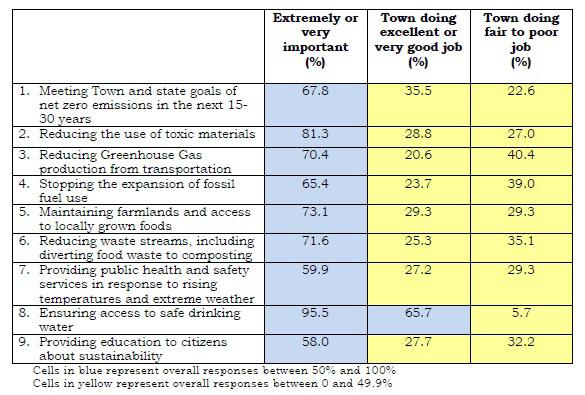
For those that said life is “worse” now than it was five years ago, they were asked to identify what is making quality of life worse. Respondents identified the following items (among other items):
• Environment. Comments from respondents on this issue addressed reduction of open (or green) spaces, loss of trees, and too many restrictions on handling of the environment/open space/private property. Additionally, respondents were concerned both about climate change in general and specific environmental issues. Specific issues included:
• Too much traffic
• Inadequate public transportation
• Too much noise
• Not enough bike and walking trails
• Inadequate infrastructure (e.g., power supplies and power reliability, conditions of roads and sidewalks)
• Failure to properly preserve the history of neighborhoods
• Not enough attention to open space and tree canopies
• Zoning. There were concerns expressed primarily about residential zoning but also about business zoning. A substantial number of respondents commented on what they perceived to be a “lack of planning.”
• Miscellaneous. Almost half of those who commented on this question expressed general negativity and frustration. Many said the Town is failing to take advantage of its history and should focus more on that. Some expressed that senior citizens deserve better treatment than they are getting, and several said bikers were a problem and safety hazard.
When considering what should be done with the remaining land that is still available for development, respondents indicated the following:
• 27.1% preferred creating affordable housing
• 11.9% preferred creating recreation fields
• 61.1% preferred preserving available open space
Respondents were asked about priorities with respect to rights of property owners and preserving the natural environment, indicating the following:
• 33.7% said it is more important to preserve the rights of property owners
• 66.3% said it is more important to preserve the natural environment
Respondents were asked to rank each of the seven broad categories based on importance:
Category Ranking
Ensuring quality public education 36.5%
Ensuring economic development 15.7%
Addressing climate, environmental health, and sustainability issues 14.8%
Delivering Town services 10.7%
Sustaining the physical character of the Town 9.5%
Providing responsible Town government 8.4%
Promoting diversity, equity, and inclusion 4.5%
Figure 5: 2022 Lexington Town-Wide Survey Results – Respondents’ Rankings of the Most Important Category
At the writing of this report, the 2022 Statewide Comprehensive Outdoor Recreation Plan (SCORP) is in the planning and development phase. However, the 2017 SCORP identified four overarching goals with 13 corresponding objectives (Figure 6).
Access for Underserved Populations
1. Support the acquisition of land and development of new open spaces in areas that lack existing or usable open spaces, such as Environmental Justice neighborhoods.
2. Develop parks and open spaces that offer amenities that go above and beyond ADA requirements for people with disabilities.
3. Consider the needs of underserved demographic groups - senior citizens and teenagers - in park and open space designs.
4. Encourage establishment of programming endowments.
Support the Statewide Trails Initiative
Increase the Availability of Water-Based Recreation
1. Support the acquisition of land and development of new open spaces that can provide a trail network.
2. Fill in the gaps of existing trail networks.
3. Ensure that any existing or new trails are fully accessible to people with disabilities.
1. Support the acquisition of land that will provide for water-based recreation.
2. Support the acquisition of land that will increase drinking water supply protection.
3. Develop water-based recreational facilities, including swimming areas, spray parks, boating facilities, fishing areas, etc.
Support the Creation and Renovation of Neighborhood Parks
1. Promote the acquisition and development of neighborhood parks where none currently exist.
2. Develop amenities supported by neighborhood parks, such as playgrounds, off-leash dog parks, and community gardens.
3. Work with community development organizations to improve walking access to local parks.
The SCORP goals and objectives align closely with the community input received during the OSRP development and planning process. Public engagement highlighted the need for more accessibility throughout parks, conservation lands, and green spaces; the importance of ACROSS Lexington and continuing to implement various initiatives; acquiring new lands; and the need for water-based recreation activities (as derived from the 2020 Community Needs Assessment).
The Town continues to address the following general areas of concern. Six were outlined in the 2015 Plan, and a seventh, Climate Resiliency Needs, has been added in the 2022 Update:
• General Open Space and Recreation Needs
• Regional Resource Protection Needs
• Historical Resource Protection Needs
• Water Resource Protection Needs
• Wildlife Resource Protection Needs
• Vegetation Resource Protection Needs
• Climate Resiliency Needs
It is understood that these areas of need have broad overlap; however, the Town presents each specific resource protection need under the area of concern in which it best fits.
The diversity in age, ethnicity, and income in Lexington’s population indicate a need to provide open space and recreation opportunities that appeal to a wide variety of potential users. The fact that Lexington’s population is getting older, as noted in Chapter 3: Population Characteristics, points toward a need for open space and recreation areas that allow access for elderly and disabled residents, entrances that permit access, and trails that are well marked and conducive to heart-healthy walks. In fact, walkable, accessible areas generally ranked very highly in the survey for what people liked about Lexington’s open spaces.
With this in mind, the Town has identified a need to develop more “All-Persons” (also called Universal Access) trails around Lexington. All-Persons Trails are designed to by usable by all people, to the maximum extent possible. While All-Persons Trails have been constructed at two Conservation parcels since 2015, the Town should prioritize identifying opportunities to implement new trails at other properties and incorporating concepts of universal accessibility into future site improvement projects. The Department of Recreation & Community Programs and the Conservation Division have surveyed buildings and open spaces in Lexington to determine which ones meet current ADA guidelines and identified where improvements are needed.
The Town’s Conservation Stewards work to improve the quality of the Town’s conservation lands. In 2015, the Town updated the Stewardship Handbook, which covers general maintenance of the Town’s conservation lands. Further, the Lexington Conservation Commission, through its consultant Massachusetts Audubon, developed and approved in February 2015 an overarching Guiding Principles and Policies Plan for all its conservation areas to address standard management issues, building of trails and bridges, and the management of invasive species.
Successful implementation of a good open space plan for Lexington requires cooperation with nearby communities and resource-oriented organizations in the region. The Town should continue and expand upon efforts to coordinate with neighboring communities regarding the protection and maintenance of open space areas that provide green corridors across town boundaries. Areas in Lexington that are particularly important to consider in the context of regional natural resource planning include Arlington’s Great Meadow (located off the Minuteman Bikeway), the Cambridge Reservoir area, the Beaver Brook North area (connecting with Waltham and Belmont via the Western Greenway), the Lexington-Burlington border along Burlington’s landlocked forest, and the area surrounding Minuteman National Historic Park (connecting with Lincoln and Concord). ACROSS Lexington will connect with trail networks in adjacent communities.
Additionally, many of the historical sites in Lexington (together with their associated open spaces) reveal their full significance only when presented in the context of their relationship to historical sites in other communities. Lexington could best present the significance of its Revolutionary War historical sites if all
the communities along the Revolutionary War battle route from Boston to Concord coordinate their presentations of this historic story, which in part is done through the Minuteman National Historic Park.
Historic preservation has always been a high priority for the Town of Lexington. In June 2006, the Massachusetts Department of Conservation and Recreation and the Freedom’s Way Heritage Association prepared the Freedom’s Way Landscape Inventory, called the Lexington Reconnaissance Report. The Freedom’s Way Heritage Association includes 37 Massachusetts municipalities that “are linked by historic events that helped to shape America’s democratic form of governance and the intellectual traditions that underpin American freedom, democracy, conservation and social justice”.1 Heritage landscapes are defined in the report as “special places created by human interaction with the natural environment that help define the character of a community and reflect its past”.2 The report identifies dozens of heritage landscapes that fall into a variety of different categories, including agriculture, burial grounds, village, industrial, institutional, military, open spaces and parks, residential, transportation, and water bodies.
There were three main areas of concern raised by the report. First, landscape stewardship was cited, although there was a recognition that the Town and private entities have done a good job in developing management plans for many of the properties. However, the loss of some heritage landscapes was seen as a loss. Second, regional landscapes such as the Arlington Reservoir, Battle Road, Arlington’s Great Meadow, and the Minuteman Bikeway were listed, and the report recommends that the Town continue to play a leadership role in communicating with neighboring communities. Third, the report mentioned the lack of a scenic roads bylaw and recommends that such a bylaw be adopted.
The largest pond in Lexington is the Old Reservoir, which serves as the Town’s recreational swimming area with a beach and lifeguards. As mentioned in Chapter 4, a 2007 study identified bacteria contamination for stormwater outfalls along Marrett Road which has since improved through implementation of the stormwater mitigation project. Historically, Vine Brook, which runs through the center of Town, has offered trout fishing, but in recent years this brook runs too low during the summer months. However, fishing is offered at the Old Res and in some of the towns adjacent to Lexington.
Lexington has 20 brooks that all flow out of town, which means that they are of special concern for downstream communities in Arlington, Belmont, Waltham, Lincoln, Bedford, Burlington, and Woburn. All of these brooks face challenges posed by non-point source pollution due to runoff from roadways, houses, parking lots, and other impervious surfaces, as well as from inputs such as pesticides and fertilizers. For instance, the Arlington Reservoir, which lies partially in Arlington and partially in Lexington, faces a major aquatic weed problem (water chestnut) due to nutrient overloading from lawn and farm run-off entering the reservoir via Lexington’s Munroe Brook. More focused efforts are needed to address the degradation that stormwater run-off causes in the Town’s brooks.
At the time of the 2009 update, Lexington’s Conservation Division, Engineering Division, and a group of citizen volunteers worked together through the Watershed Stewardship Program to monitor and tend to the health of the streams. The program conducted observational stream surveys on all of Lexington’s streams to develop a better understanding of the issues that affect their health and function. By the 2015 Update, the program was being coordinated solely by the Engineering Division and engaged students from the University of Massachusetts Lowell through an internship program.3
1 Massachusetts Department of Conservation and Recreation and Freedom’s Way Heritage Association, Lexington Reconnaissance Report, June 2006, p. 1
2 Ibid.
3 Watershed Stewardship Program, Lexington Engineering Department: https://www.lexingtonma.gov/277/Stormwater-Management
Lexington’s open spaces provide important habitat for wildlife in a densely human-populated area of the state. Additionally, a wide diversity of wildlife supports the ecological health of natural areas. Lexington should continue to identify and certify vernal ponds, undertake land management efforts that enhance wildlife habitat, and expand the network of wildlife corridors within town and connect with other towns.
The Conservation Commission should encourage vegetation surveys, particularly in wetland areas, identify threats to plant diversity, monitor invasive species, and ensure the protection of unique plant communities. In addition, there is a need to identify trails that are vulnerable to erosion and loss of vegetation and clearly mark and maintain trails to encourage hikers to stay on them rather than trample vegetation.
As described in Chapter 4: Environmental Inventory, the Town of Lexington faces impacts from climate change including more frequent extreme weather events and an overall increase in temperature. Extreme weather events are likely to result in damage to open space and recreation property, infrastructure, and natural resources. When considering the development or improvement of open space and recreation areas, the Town should consider the projected future impacts of climate change and plan for resiliency during the design and engineering phase. The Town should also consider the protection of open spaces important for conservation, which may be especially at risk of flooding during extreme storms. The Town has made substantial progress on erosion and flood control projects and should continue to plan erosion control and wetland restoration projects with the goal of increasing the climate and flooding resiliency of adjacent conservation areas and habitat, in addition to economy and manmade infrastructure; for example, the flood control improvements installed at the Harrington School have been successful in reducing rates of stormwater flow that had previously been linked to erosion.
There is also potential for open space areas to contribute enhanced resiliency for other Town infrastructure and property. For example, open space areas can be designed to capture runoff from extreme rainfall events and detain or redirect the water above ground, reducing the risk of overloading storm and sewer drainage systems. Furthermore, implementing these vegetated systems of stormwater control at developed properties can also increase the overall amount of open space around Town, creating new opportunities for ecological restoration, potential habitats and wildlife corridors, and carbon sequestration in areas where these resources may not have existed previously.
It is clear that climate resiliency needs will continue to increase in magnitude in the coming decades. The Town of Lexington should plan proactively to protect its natural and manmade resources and infrastructure from extreme weather events following best practices established by the Commonwealth of Massachusetts,
Currently, the Lexington Conservation Office employs three year-round staff (a full-time director, a full-time coordinator, and a part-time ranger). To manage the 1,400+ acres of town-owned conservation land and easements, approximately 1,000 volunteer hours are used annually. According to the Value of Volunteer Time produced by Independent Sector, 1,000 volunteer hours equate to approximately $36,380 in donated time. Given the reliance on volunteerism, a volatile workforce, several potential actions can be taken based on public feedback to continue improving and enhancing Lexington’s conservation areas:
• Increase volunteerism
• Pursue shared services agreements with other departments and organizations
• Hire more dedicated staff
• Pursue contracted maintenance services when appropriate
• Increase dedicated funding for staff training, conservation management, and tools and supplies
At a minimum, more resources are necessary to maintain the existing and future conservation land system. Enhancements are desired today, and any future system expansion will immediately affect level of service if commensurate resources are not provided simultaneously with the acquisition of new spaces.
Additionally, a performance measure should be created that identifies the desired number of full-time equivalents (FTE) per maintained acre of open space. If including average number of volunteer hours donated annually, there are approximately 2.7 FTE maintaining the system. A closer examination is warranted to understand the number of actively maintained acres (acres that require/necessitate active resource management or maintenance activities) and the FTE level that is required to effectively maintain those acres to meet both resource goals and community expectations. Establishing a metric based on required maintenance activities will provide the Town of Lexington with a guide for staff development.
Two of the five recommended potential actions from above are explained further in the following sections.
Many agencies utilize third-party, or contractors, for maintenance services. Typically applied to more “active” recreation areas, the same ideology can be applied to conservation lands. For Lexington, this notion is relevant because of the reliance on volunteer services and the need to create flexibility in the way it manages and oversees conservation lands. The Town of Lexington should adopt and implement a contracted services matrix/guide to assist with decision-making if (and when) contracted services are a potential appropriate source of assistance (Figure 7).
Each criterion in the matrix/guide addresses a different facet of contracting maintenance services that allow for a data-driven decision to occur. Once each criterion is vetted and the score calculated, contracted services receiving a twelve (12) or above should be considered for an agreement. After the review and scoring process, the Town of Lexington should then identify the type and length of the ideal maintenance/service agreement/contract (such as fixed/variable cost or annual).
A Yes = 2 Some = 1 No = 0
B Yes = 2 Some = 1 No = 0
C Yes = 2 Some = 1 No = 0
D More = 2 Same = 1 Less = 0
E Yes = 2 Some = 1 No = 0
F Yes = 2 Some = 1 No = 0
G Yes = 2 Some = 1 No = 0
H Yes = 2 Some = 1 No = 0
Will this allow us to direct (or redirect) resources and attention to our core competencies?
Does contracting this service address an operational issue(s)?
Does contracting this service increase the ability to stay current with technology and maintenance practices?
What is our unit cost compared to a contracted cost?
Do we have the capacity (or can create it) for contract administration, oversight, and management?
Will contracting this service increase the lifespan and/or performance of an asset?
Will contracting this service increase (or at least maintain) our desired level of standard/care?
Is this contracted service something that we cannot do ourselves for whatever reason(s)?*
*If yes, mandated contracted service Score (12 or above should contract)
Figure 7: Contracted Services Matrix/Guide
Based on public engagement, the top three improvements residents would be most willing to support with their tax dollars include:
1) Enhancing existing conservation areas
2) Acquiring land for conservation
3) Increasing maintenance of trails and boardwalks
Given this information, a funding source matrix should be created to help identify federal, state, and local funding sources along with potential project(s) that would most align with the funding source’s goals. Additionally, funds should be identified that can assist with staff training, development, and tools and materials acquisitions as appropriate. The following funding sources and funding methods should be included (at a minimum) in a funding matrix:
• Land and Water Conservation Fund
• Parkland Acquisitions and Renovations for Communities (PARC) Grant Program
• Local Acquisitions for National Diversity (LAND) Grant Program
• Gateway City Parks Grant Program
• Landscape Partnership Grant Program
• Conservation Partnership Grant Program
• Drinking Water Supply Protection (DWSP) Grant Program
• Conservation Land Tax Credit Program (private donations)
• Enterprise Fund
• Cash capital
• Community Preservation Act (CPA)
As a result of the previous OSRP, Lexington has created Open Space and Recreation Facility Management Plans for many areas. The intent of these plans is to outline how to best utilize the existing Town management structures and resources, determine short- and long-term site goals, and create a schedule of maintenance activity. To continue meeting community expectations, it is necessary to continue increasing efforts to combat invasive species, enhance native habitats and wetlands, prevent encroachments, and schedule appropriate maintenance activities. As identified by the statistically-valid community survey, residents believe maintenance of open spaces should receive the most emphasis from the Town of Lexington over the next five years.
Land management plans should be created for those properties that do not have one developed. Additionally, existing land management plans should be reviewed regularly for implementation status and should be placed on a review and update schedule to keep the information responsive to site challenges, best practices, and community expectations.
In the past, the OSRP has approached goals differently. While historically intended to be broad and lofty, most of the objectives laid out in the 2015 plan were also presented as actionable. As the 2015 and 2009 goals were reassessed for 2022, and as it was noted that many of the goals have persisted from 2009 onward with only minor modifications, it became clear that many of the objectives cannot and should not be “accomplished” as such. Rather than restructure these ongoing initiatives into achievable action items for the purpose of creating an action plan, the decision was made to rethink the way the goals, objectives, and action items are to be conceptualized in 2022.
The fundamental role of the OSRP has been to guide the continued maintenance, ongoing development, and future expansion of the open space and recreational assets within the Town of Lexington through the Conservation Division and Recreation & Community Programs Department. At the same time, various departments within the Town have commissioned many different planning and goal-setting efforts which approach the broader issues of land use, capital planning, and community programming needs through different lenses, some of which may conflict. In updating this plan, through public engagement and stakeholder meeting sessions, the need to mitigate conflict between departmental interests was brought to the forefront.
In recent years, the Town of Lexington has made strides to increase communication and collaboration between departments. The OSRP Working Group believes that the next step for the Town is to fit these new planning efforts into a broader roadmap for future planning in Lexington, so that each plan and its goals contribute to a common end without superseding or making redundant the work of another. A decision was made to reformat the OSRP goals into a framework that centers the increasing need for collaboration, conversation and synergy between Town departments and other planning efforts. It is the goal of the Working Group to use the OSRP as a tool to strengthen this connection and communication and create a reciprocal relationship that ensures the work of other departments is considered in the work described in the OSRP, and vice versa.
This updated plan categorizes the objectives and undertakings of the Conservation Division and Recreation & Community Programs Department into an open-ended framework anchored by eight conceptual “goals”. The new goals are designed to streamline and augment the nine goals described in previous iterations of the OSRP, to remove redundancies within the goals, and to connect the work of the authoring departments to Town-wide comprehensive planning efforts. By reframing the updated goals as concepts, the ideas comprised in the 2022 OSRP update will be easy to understand and apply across Town planning efforts, strengthening opportunities to create connections between plans and increase synergy throughout Lexington.
The 2015 Open Space and Recreation Plan was structured around a set of nine goals developed through community surveying, public engagement, and review of existing open space and recreation sites. As part of the update process, these nine goals were reexamined for their continuing relevance in 2022. The goals established by the 2015 OSRP were as follows:
1. Establish and implement a land management program that will assure optimal maintenance and use of conservation lands.
2. Protect Lexington’s natural environment, both within and beyond the borders of open space and recreational properties.
3. Promote public use of recreational facilities and open space among a wide variety of user types.
4. Provide a balance of recreational activities across all demographic groups of Lexington citizens.
5. Enhance access to and connectivity between open space and recreation areas.
6. Acquire and protect parcels that are important from an environmental, recreational, or historical perspective.
7. Protect and maintain Lexington’s water resources.
8. Maintain and expand Lexington’s open space and recreational infrastructure.
9. Expand upon and create new opportunities for bicycling and walking throughout Lexington.
In addition to these nine overarching goals, specific objectives and action items were created as detailed in a 7-Year Action Plan for the Town of Lexington. As part of the 2022 Update, these objectives were revisited to assess their current status of completion and catalog relevant actions taken by the Town. A summary of these actions with status updates is included in Chapter 9 of this report.
Based on this review and update, it seemed that progress over the last seven years was easier to qualify for some than others. Some of these nine goals were presented as potentially achievable through concrete actions, while others were written to be only conceptual. Some contained many objectives, while others contained very few. There were objectives that could only be reviewed by other departments, and it was found that little work had overlapped with that of the authoring departments over the last seven years. In developing new goals for the 2022 OSRP, consistency in these regards was prioritized. The new goals and objectives were written to be broad and conceptual at the level of the goals, easily qualified by the Conservation Division and Recreation & Community Programs Department at the level of the objectives, and connected to the objectives at the level of the action items. Aiming to generate a relatively consistent number of objectives and action items for each goal ensured that none appeared to take precedence over the others. Most importantly, the update reviewed and reorganized objectives that could seem redundant in order to streamline the goals and clarify where progress should be recorded.
Since the adoption of the 2015 Open Space and Recreation Plan, departments and committees within the Town of Lexington have completed a number of comprehensive planning efforts, culminating in the adoption of sets of goals and action items for each. While the goals detailed in the individual plans may pertain to other areas, many are linked with open space and recreation. These goals were cross-referenced with the 2015 OSRP goals with the intent to curate an updated list of goals for open space and recreation that are maximally relevant to the Town’s overarching efforts.
The relevant reports and plans that were cross-referenced are as follows. This list is only a sample of the most comprehensive plans and reports authored by the Working Group. In addition, the Working Group referenced priorities established in plans created by the Greenways Corridor Committee, Historical Commission, and Sustainable Lexington, among others.
Biannual goals set by the Select Board
1. Lexington is a visionary and sustainable community that values and respects all people, history, and community assets.
2. Lexington provides opportunities for all people to participate in community activities and benefit from Town services that are affordable, accessible, and responsive.
3. Lexington delivers quality municipal services, infrastructure, and amenities for all.
4. Lexington is committed to fiscal stewardship.
5. Lexington supports its thriving local economy by partnering with the private sector.
Comprehensive Plan (2022), by Town of Lexington
1. To increase the DIVERSITY and promote the INCLUSION of people visiting, living and working in Lexington.
2. To enable and encourage a wide range of HOUSING OPTIONS that are inclusive for all life stages, incomes, and needs.
3. To promote a VITAL ECONOMIC SYSTEM that is self-sustaining, supports a variety of small and large businesses, contributes to the tax base that support the town, and improves the balance of services to meet the needs of residents, employees, and visitors.
4. To protect the ENVIRONMENT and enhance long-term SUSTAINABILITY and RESILIENCE.
5. To protect OPEN SPACES and NATURAL RESOURCES and enhance connections among these assets.
6. To protect, preserve, and promote awareness and appreciation of Lexington’s HISTORIC RESOURCES from throughout its history.
7. To make TRAVELING into, out of, and within Lexington safe, pleasant, and efficient with sustainable and equitable mobility options for all ages and abilities.
8. To improve and expand facilities for RECREATION AND COMMUNITY GATHERING to support holistic wellbeing, a sense of belonging, enhanced social connections, and opportunities for fun.
9. To provide well maintained, updated, inclusive, and sustainable PUBLIC FACILITIES to serve and meet community needs.
Annual goals set by the Conservation Division Land Management Planning Invasive Plant Management & Native Habitat Restoration Conservation Meadow Preservation Trail Access & Infrastructure Trail Connections Education & Outreach Land Acquisition Historic Landscape Preservation
Community Needs Assessment (2020), by Department of Recreation & Community Programs
Programming Facilities Maintenance Community Marketing System Funding Park Classifications Business Planning
Cross-referencing the Town-wide comprehensive planning goals in the Comprehensive Plan and Select Board goals with the OSRP goals revealed multiple relevant areas of interest that are prioritized in other reports and were not captured in the nine goals established in 2015. The 2022 OSRP update intends to reflect any relevant transitions in the Town’s priorities over the last seven years in the updated goals, in addition to supporting these efforts with updated action items, detailed later in this report in Chapter 9.
The circular chart on the previous page notes connections between the five Select Board goals, nine Comprehensive Plan goals, and eight OSRP goals. The Select Board and Comprehensive Plan goals are reiterated below:
1 Lexington is a visionary and sustainable community that values and respects all people, history, and community assets.
2 Lexington provides opportunities for all people to participate in community activities and benefit from Town services that are affordable, accessible, and responsive.
3 Lexington delivers quality municipal services, infrastructure, and amenities for all.
4 Lexington is committed to fiscal stewardship.
5 Lexington supports its thriving local economy by partnering with the private sector.
DIVERSITY & INCLUSION To increase the diversity and promote the inclusion of people visiting, living and working in Lexington.
HOUSING OPTIONS To enable and encourage a wide range of HOUSING OPTIONS that are inclusive for all life stages, incomes, and needs.
VITAL ECONOMIC SYSTEM To promote a vital economic system that is self-sustaining, supports a variety of small and large businesses, contributes to the tax base that support the town, and improves the balance of services to meet the needs of residents, employees, and visitors.
To protect the environment and enhance long-term sustainability and resilience.
OPEN SPACES To protect open spaces and natural resources and enhance connections among these assets.
HISTORIC RESOURCES To protect, preserve, and promote awareness and appreciation of Lexington’s historic resources from throughout its history.
TRAVELING To make traveling into, out of, and within Lexington safe, pleasant, and efficient with sustainable and equitable mobility options for all ages and abilities.
RECREATION & GATHERING
To improve and expand facilities for recreation and community gathering to support holistic wellbeing, a sense of belonging, enhanced social connections, and opportunities for fun.
PUBLIC FACILITIES To provide well maintained, updated, inclusive, and sustainable public facilities to serve and meet community needs.
When comparing the goals of the Select Board and the Comprehensive Plan, it was clear that the two were designed in lockstep, with each goal in each plan easily connected to another goal in the other. The OSRP Update is designed to mirror this strength of connection. Colored circles corresponding to each of the new OSRP goal categories connect to each of the nine Comprehensive Plan goals, which are laid out as fractions of a ring. Concentric circles within the ring denote which of the Select Board goals can be connected to each of the Comprehensive Plan goals, and transitively to the OSRP goals in the outer circle. It is clear from this exercise that no goal exists by itself; apparent connections can be drawn between the three plans. By positioning the goals of the OSRP in conversation with the overarching goals of the Town of Lexington, this plan hopes to generate or augment communication and synergy between Town departments.
Direct input from the community was also sought during the reexamination process. Two public forums were conducted via Zoom, where community members were introduced to the OSRP including a review of the 2015 goals and feedback was requested through the use of polling questions and Q&A features. Participants were asked to rank and respond to the nine goals established in the 2015 OSRP on a scale of 1 to 5, with one being least important/relevant and 5 being most important/relevant. Then, participants were asked to indicate if any of the established goals are no longer relevant to today and/or if anything is missing from the goal statements.
Through their average ranking, participants indicated that protecting Lexington’s natural environment and water resources are the top two goals for the next seven years, with an average score of 4.2 out of 5. The goals that the community rated least in importance included maintaining and expanding Lexington’s open space and recreational infrastructure and promoting public use of recreational facilities and open space among a wide variety of user types, with an average score of 3.3 out of 5. The very small difference between the highest and lowest scores and the lack of very low scores indicate that overall, open space and recreation is highly valued in the community and all efforts to improve the Town of Lexington’s open space assets remain a high priority.
Drawing from comments gathered from stakeholder and public engagement sessions, a SWOT analysis was generated for the attributes of the Town of Lexington as they relate to open space and recreation. A SWOT analysis asks respondents to list perceived strengths (most positive attributes), weaknesses (negative or absent attributes), opportunities (ideas to transform or expand attributes and offerings to address weaknesses), and threats (external factors that influence weaknesses). The public forums and stakeholder engagement sessions asked participants to provide feedback in each category, and the statistically valid survey provided multiple choice questions about strengths and weaknesses as well as comment boxes where respondents could elaborate on their selections.
A similar SWOT analysis was conducted in 2015 as part of the public engagement process and was published in the 2015 OSRP. The results of the 2015 and 2022 analyses can be directly compared to track changes in public opinion over the last seven years.
Users in 2022 valued the quantity of open space as Lexington’s greatest strength. In 2015, users valued existing community and maintenance/management most highly; both of these values rank low on the list of strengths identified in 2022. By contrast, users in 2022 identified maintenance/management and funding for open space as Lexington’s greatest weakness.
In 2015, the greatest weakness identified by users was a lack of sports and recreational offerings; this high ranking persisted in 2022. As such, in both 2015 and 2022 a majority of users noted that expanding sports and recreational offerings could be the Town’s greatest opportunity and offered their suggestions, such as water sports, winter sports, and pickleball; the latter was highly desirable in 2022. This response correlates with a surge in pickleball interest that has been observed nationwide and has also been reflected in the results of the Community Needs Assessment and the statistically-valid survey.
The threat of development reigned supreme in both 2015 and 2022, though a greater share of respondents in 2022 noted that it was their highest concern. Public perception of threats remained relatively consistent. The threat of invasive species and climate change and the threat of damages from overuse continued to rate highly, just below development, in both years.
Comparing the results of the two SWOT analyses also reveals signs of progress towards achieving some of the goals laid out in the 2015 OSRP. For instance, users in 2015 noted that accessibility was a weakness throughout the Town, and in 2022 a large percentage of users rated accessibility as a strength. Similarly, a drop in users and a change in user interest was considered a significant threat in 2015 and is no longer considered a threat in 2022; meanwhile, users in 2022 identified diversity of users and programming as a strength.
The 2022 Open Space and Recreation Plan Update was spearheaded collaboratively by the Conservation Division and the Department of Recreation & Community Programs. With the consultants, these two organizations formed the core working group for this report. However, noting that connections exist between open space, recreation, and the work of other Town departments, it is pertinent to connect with other organizations to determine how the OSRP fits into the broader objectives of the Town of Lexington and can assist other boards, committees and departments in meeting their goals.
The Town of Lexington conducted multiple small-group stakeholder meetings with other boards, committees, and Town departments. The goal of these sessions was to disseminate information about the OSRP Update, spread awareness about the community engagement sessions, and receive feedback on the successes and shortcomings of the 2015 OSRP and other efforts related to open space and recreation. Stakeholder groups engaged included:
• Commission on Disability
• Community Preservation Committee
• Conservation Commission
• Recreation Committee
In addition to meeting with these groups, the Greenways Corridor Committee and LexPride were consulted via e-mail to provide commentary on the successes and failures of the 2015 OSRP. These meetings and online correspondence were critical in revealing conflicts of interest as well as areas of interest that had been previously overlooked.
During this process, new priorities emerged, as did conflicts between interest groups. Meetings with stakeholder groups highlighted the need for synergy between departmental planning efforts and the desire to develop universal methods for resource allocation and assessment. Strengths and weaknesses gathered from the community showed progress that could not otherwise by easily quantified, and more importantly identified where progress was lacking. Survey results identified areas were public interest and opinion was changing. Based on the cross-examination and the ratings and comments collected from the community, the 2015 OSRP goals were able to be expanded further with additional action items and objectives as detailed in the following 2022 goals and the updated 7-Year Action Plan.
The working group would like to thank everyone who participated in this effort for their comments, questions, and feedback.
The nine 2015 OSRP goals were re-examined, consolidated and expanded upon to generate the following eight goals, which will serve as guidelines for open space and recreation planning efforts through the year 2029. These eight goals will be described in greater detail in the remainder of this chapter, which defines a list of key objectives for each goal, and in Chapter 9, which generates from the goals and objectives an action plan listing specific projects and priorities for the next seven years. In connection with the work of other departments and committees, coordinating public/private partnerships and funding efforts will be prioritized in the objectives and action items that follow from these goals. Each goal will be presented with a simple name, followed by a one-sentence statement of purpose. To the right, a list of keywords will be provided to further simplify and differentiate the goals. In this plan, each goal is also represented by an icon and color. These symbolic representations have been used throughout this chapter, and can be integrated into future OSRP updates and related reports to track progress and easily identify where connections can be drawn. Objectives, which follow in a bulleted list, represent the “why” of each goal and begin to explore desired outcomes.
Increase the efficacy of communication and collaboration with other Town departments, citizen groups and neighboring communities.
• To increase collaboration opportunities between the Conservation Division and Recreation & Community Programs Department, and between all Town departments regarding goals for open space and recreation.
• To simplify and/or unify methods of communication and outreach from the Conservation Division and Recreation & Community Programs Department to the community.
• To increase collaboration with bordering communities that share or abut open space parcels or watersheds.
Improve access to programs and facilities for people of all ages, abilities, identities and backgrounds.
• To provide a balance of facilities and opportunities throughout environmental justice (EJ) neighborhoods.
• To complement LexNext Goal 1: Diversity and Inclusion efforts.
• To create more inclusive outdoor experiences for all.
Provide a balance of activity and educational opportunities for all of Lexington’s citizens.
Cultural Connections Education Community Center
Programming
• To capture the work of other committees and reflect the results of Comprehensive Planning efforts and Community Needs Assessments, including cultural diversity goals, in future programming.
• To continue to be cognizant of the need to diversify year-round recreational opportunities to reflect Lexington’s demographics.
• To utilize connections with volunteer organizations/groups to increase programming opportunities.
• To identify opportunities for collaborative programming between Conservation and Recreation.
Allocate capital efficiently in order to maintain, preserve, and grow open space and recreational infrastructure for many years in the future.
Grant Funding Operational Costs
Long-term Preventative Maintenance Infrastructure Expansion
Transportation & Connectivity Communication
Capital Projects
• To continue to complete 5-year outlooks for projects for the Conservation Division and Recreation & Community Programs Department.
• To coordinate between the Conservation Division and Recreation & Community Programs Department on capital projects within the same open space areas as part of 5-year capital planning.
• To plan for the future maintenance/replacement needs of capital projects and determine effects on other budgetary needs.
• To utilize the goals and objectives within the OSRP to identify potential projects that will help achieve other OSRP goals.
Identify and establish open space management programs that will assure optimal maintenance and use of Townowned lands.
Transportation & Connectivity
Programming Environmental Protection
Accessibility
Short-Term Maintenance Invasive Species Restoration Stewardship
• To create land management plans to inventory resources and identify operation, management, infrastructure and maintenance needs at a property.
• To identify alternative funding sources to support maintenance and management
• To establish typical materials to be used consistently in certain project types to ease maintenance of infrastructure including when items need to be replaced.
Communication Accessibility
Land Management Environmental Protection
Acquisition
Protect Lexington’s natural environment and resources, both within and beyond the borders of open space and recreational properties.
Conservation Restrictions Climate Resilience Stormwater Management Carbon Sequestration Resource Conservation
• To create or promote guidelines for open space projects that emphasize environmental protection, native species protection, and water conservation.
• To consider the role of open space and recreation land in climate mitigation, resiliency, and carbon sequestration.
Enhance connectivity between open space and recreation areas and develop intermodal transportation opportunities throughout Lexington.
• To enhance connectivity between open space areas via pedestrian and bicycle.
• To promote use of open space and recreational facilities while protecting areas and investments.
Assess, acquire, and protect parcels that are important from an environmental, recreational, or historical perspective.
Intermodal Transportation Corridor Projects Complete Streets Access Transportation & Connectivity Programming
• To continue to assess each parcel for best uses in collaboration with Conservation, Recreation, Planning, and the Select Board.
• To continue to identify private land that is useful to meeting open space goals.
The mission of the Seven-Year Action Plan is to categorize and describe attainable action items that strengthen and support the goals of the OSRP. The action items are a blend of conceptual and concrete projects and/or initiatives. Where appropriate, they will reference other departmental planning documents to strengthen connections in overall Town planning efforts.
The action items in the following plan were not conceived in a vacuum, nor can they be implemented in one. These action items are building blocks that have been identified to compliment, support, and respond to other comprehensive planning and goal-setting initiatives underway within the Town of Lexington. As these other initiatives were authored by many different Town departments and committees, with the support and participation of stakeholder groups, surrounding communities, and the general public, to address these objectives through the action items will require organizational collaboration between departments. Enhancing the methods and means of collaboration is a key focus of the OSRP and is featured prominently within the Communication goal.
The Seven-Year Action Plan is also useful in identifying which actions may need to be prioritized in order to make the most progress. In 2015, the OSRP described the need for increased funding, oversight of other departments, and support from other departments as the three most essential priorities for that year’s plan. With the goals re-contextualized as a means to introduce synergy rather than a means to achieving an end, the action items that come to the forefront have begun to shift. For example, there are still competing needs between various interest groups, particularly where land acquisition is concerned. Where the 2015 plan suggested creating a new singular body in the form of an oversight committee to coordinate the actions of various groups towards the goals laid out in the OSRP, the 2022 plan suggests undoing some of the compartmentalization that has been put in place in the past. In this way, the 2022 OSRP is designed to fit into a broader network of planning initiatives; it is not suggested that its goals attempt to take precedence over the goals of any other plan.
At the end of this chapter, the new Seven-Year Action Plan will be introduced. This plan aims to identify a key intention for each departmental undertaking, based around the eight new goals and new priorities of coordination, streamlining, and longterm planning.
The OSRP is a living document that views its list of goals not as a board to be cleared but as lenses through which to organize work. Though the format of the goals has changed with the 2022 update, this basic principle has remained. Since 2015, few objectives from the action plan were left unexamined. The following is a summary of significant accomplishments since the 2015 Plan was adopted.
Goal 1: Establish and implement a land management program that will assure optimal maintenance and use of conservation lands.
• Continue to develop and implement conservation land management plans that address both townwide and site-specific issues, including invasive species (approximately two each year).
The Conservation Division completed a Principles and Policies for Management of Lexington Conservation Land plan and has created targeted land management plans for Cotton Farm, the Leary Property at Lower Vine Brook, Wright Farm, and Willard’s Woods and the Chiesa Farm Field Management Plan using various funding sources including CPA funding.
• Continue to coordinate and build capacity for volunteer organizations that assist Town staff in monitoring and maintaining Town conservation lands.
The Conservation Division continues to engage more than 1,000 hours of volunteer labor annually and has developed partnerships with Grace Chapel, Boy Scout Troops 10, 119, and 160, Girl Scout Troop GS 63054, Lexington High School 9th Grade honors earth science faculty, Minuteman Technical High School environmental science faculty, Boston Cares’ corporate volunteer program, among others.
The Conservation Division has collaborated with Eagle Scout candidates in installing improvements at multiple sites over the last seven years, including new benches and picnic tables, boardwalk and fence repairs, signage improvements, installation of a firepit, improvements at the Idylwilde Community Gardens, and trail maintenance.
• Increase funding to support conservation efforts and projects.
Over the last seven years, the Conservation Division has raised approximately $5,000 annually through annual citizen donations to the Lexington Nature Trust and another $15,000 annually to the Lexington Nature Trust Fund through MOU agreements with various commercial developments in Town. In addition, the Conservation Division received funding through Program Improvement Requests for additional summer field crew staffing in FY20 and for the purchase of land management equipment in FY17 and FY20. Utilizing CPA funding, the Conservation Division has secured approximately $1,537,000 in funding for conservation projects and land acquisitions. An additional $20,900 has been secured through other grants.
• Increase visibility of conservation area through standardized kiosks, entryways and wayfinding signage, and provide visitor amenities such as bike racks and parking. Include ACROSS Lexington as part of this effort.
The Conservation Division installed 12 new informational kiosks using two standardized designs, re-installed new standardized entry-way signage at 16 property entrances and developed a standardized wayfinding signage system that has been installed at Whipple Hill, Lower Vine Brook, and Meagherville. Interpretative educational signage was installed at three sites: Cotton Farm, Hayden Woods, and Parker Meadow.
Conservation Division staff supported the planning and marking of a number of new ACROSS Lexington routes.
Bike racks were installed at 10 conservation entrances through a MAPC grant and in partnership with the Planning Department. The parking areas at Cotton Farm and Parker Meadow have been reconstructed for accessibility with plans to upgrade the parking at Willard’s Woods.
2:
Lexington’s natural environment, both within and beyond the borders of open space and recreational properties:
• Continue to identify, certify, and protect vernal pools in Lexington. Outreach to landowners regarding vernal pool identification and certification.
Since 2015, four vernal pools have been certified in Lexington. Conservation Division staff collaborated with volunteers and Lexington High School Conservation Club members to do a more thorough vernal pool assessment in 2021 and 2022.
The Conservation Division protected two sensitive open space parcels, totaling 4.63 acres and containing two certified vernal pools, through a generous conservation land donation from the Burns Family.
• Coordinate with neighboring municipalities to protect and maintain lands of conservation or wetland significance.
The Conservation Commission has been actively engaged with Arlington Conservation for the Arlington Great Meadows and Reservoir, Burlington Conservation Department and Friends of the Landlocked Forest for trail connections between Wright Farm and the Burlington Landlocked Forest, Cambridge Water Department for their water supply, as well as the Towns of Lincoln and Concord for regional collaboration within surrounding towns.
• Implement land management plans for strategically managing invasive plant and pest species in Lexington, working with the Tree Committee, volunteer citizen groups, non-profit organizations, and schools.
The Conservation Division developed the comprehensive Principles and Policies for Management of Lexington Conservation Land document as well as five site-specific land management plans at Cotton Farm, Wright Farm, the Leary Property at Lower Vine Brook, Willard’s Woods, and Chiesa Farms that address invasive plant management. These land management plans have resulted in annual work to control black swallowwort, garlic mustard, Japanese stiltgrass and Japanese knotweed, among other high priority invasive plants.
In 2016, the Conservation Division formed the Lexington Invasive Plant Task Force with representation from the Conservation Stewards, Citizens for Lexington Conservation, and DPW to help plan and prioritize invasive plant projects in Lexington.
• Improve management of conservation restrictions.
Conservation Division staff and members of the Citizens for Lexington Conservation are in the process of filing conservation restrictions and baseline documentation for four Town-owned conservation properties purchased with CPA funding; the Leary Property at Lower Vine Brook, Cotton Farm, and the two “Goodwin Parcels”. These parcels are monitored on an annual basis by Citizens for Lexington Conservation volunteers in coordination with Conservation staff. Conservation Division staff are currently working on prioritizing vulnerable Town-held conservation restrictions with plans to develop baseline documentation and institute a monitoring program starting in the future.
• Continue to update web-based resources to educate Lexington residents on conservation related information.
Conservation Division Staff supported the new Town website update in 2022 and improved and streamlined volunteer sign up and reporting. Staff have developed several new webpages available on the Conservation Division website: Current Conservation Projects, Invasive Plants in Lexington, and Public Land and Trails. In addition, online forms for registering as a volunteer Steward and for reporting volunteer hours and filing monitoring reports were added and are used frequently.
among a wide variety of user types:
• Increase outreach and education efforts to local and social media sources, and e-mail subscriber lists regarding recreation and conservation resources and programs and events, including new programs at the Community Center.
The Conservation Division publishes between 2-4 articles in the Lexington Minuteman annually to promote its projects and posts to both the Town’s and the Lexington Minuteman’s online events calendars to promote volunteer events. Conservation events and other notices are included in the Town’s overall weekly emails. Conservation staff also publish a monthly E-newsletter for volunteer Conservation Stewards.
The Recreation & Community Programs Department has implemented the use of several marketing/ outreach tools including Facebook, Instagram, a monthly e-newsletter, and an upgraded website. A Capital landing page was added to the website to maintain project updates, presentations and information. In addition, Recreation now places A-frames with capital updates, seasonal registration information and event announcements through the park system. The Recreation & Community Programs Department has also joined the Chamber of Commerce and participates in the Community Coalition Coffee Hours.
In 2021, Recreation & Community Programs Department staff offered a Lexington Park Pop-Up Series. The year-long series rotated through various parks and open spaces in Lexington, a different one each month, offering safe, organized activities that engaged the community and exposed residents to areas that may have been unfamiliar. The goal was to encourage residents to return to the parks in the future, fostering stewardship and continued exercise. The activities promoted heart health, diverse abilities, artistic expression and friendly competition.
Events held by the Conservation Division have included annual fall apple picking events at Cotton Farm, spring celebration events at Wright Farm, and the Nature Speaker Series in 2021 and 2022 in collaboration with Lexington Living Landscapes (LLL). The Conservation Division also collaborated with LLL to establish a native pollinator kit program.
In Fall 2018, the Conservation Division hosted a series of free public programs at Wright Farm in partnership with the Recreation & Community Programs Department and in 2019 hosted a series of free public workshops on home orchard care at Cotton Farm. The Recreation & Community Programs Department is able to register participants in these various events through their online system.
• Offer regular open space education activities throughout the year.
The Conservation Division and Recreation & Community Programs Department have hosted numerous educational activities, including the aforementioned free joint public workshops at Wright Farm and Cotton Farm. In collaboration with UMass hosted a bee ID workshop in summer 2022. The Citizens for Lexington Conservation offer free public bird and nature walks for residents at Conservation areas typically in the spring and fall, beginning in 2015. Conservation Rangers lead dendrology workshops in the winter and hosted a bee identification workshop in the summer of 2022. In addition, the Conservation Division hosts periodic trainings for its Steward volunteers.
Since 2019, the Town of Lexington has participated in the City Nature Challenge, an international event taking place annually in Spring to catalog wildlife in urban areas. In 2022, 50 participants collaborated to identify 339 unique species in Town.
• Plan and construct improvements that will provide access to programs and facilities for residents with disabilities, using ADA and MA AAB standards.
The first universally accessible loop trail in the Lexington trail system was constructed at Parker Meadow in 2022, supported by CPA funding. As a part of the accessibility improvements at the site, parking upgrades were also constructed. Another universal access trail is under construction at Cotton Farm, which will also include accessible parking. The Conservation Division also received CPA funding in FY20 for the design of universally accessible parking and trail improvements to Willard’s Woods. A
1 For more information on the CHNA initiative and programming in Lexington, visit the CHNA15 Homepage: https://www.chna15.org/ home
concept plan for the improvements at Willard’s Woods was completed in 2021, and is expected to be submitted to the CPC for construction funding for FY24.
The Recreation & Community Programs Department completed the ADA Study of Recreation facilities in 2017. Since then, renovations and accessible improvements have been made to a number of facilities, including accessible pathways at Diamond Middle School, Sutherland Park, Marvin Park, the Center Reservation Complex, the Old Reservoir Bathhouse, and the Pine Meadows Golf Course; parking and pathway improvements at Adams Park and the Community Center; ADA bleacher systems at Lincoln Field #2 and the Center Recreation Complex; and an accessible family changing room and new accessible lifts at the Town Pool.
Lexington engages with the Commonwealth’s Community Health Network Area (CHNA) initiative as a part of CHNA15, which supports the development of programming to encourage community members of all ages and abilities to visit and use open space and recreation areas.1
In 2019, a part-time Certified Therapeutic Recreation Specialist (CTRS) was hired to develop and create an inclusion program. The position became full-time in 2020.
• Work with other Town departments and citizen groups to identify how to best increase the use of recreational facilities and programs, including the feasibility for lighting athletic fields.
The Recreation & Community Programs Department completed a Community Needs Assessment to guide future program, service and facility planning based on outcomes and trends. Goals and objectives from the Community Needs Assessment were referenced to create the 8 updated goals for the 2022 OSRP Update. A playground audit of all Town playgrounds was also completed in 2020 to determine the lifespan of existing facilities, in addition to reviewing the sites for accessibility.
• Continue to be cognizant of the need to diversify year-round recreational opportunities to reflect Lexington’s demographics, including specialized events with local cultural organizations.
In 2017, a Community Stakeholders group was created that meets quarterly to discuss best practices, trends and supportive resources. An annual Community Open House highlighting Town-wide summer opportunities for youth and teens was launched in 2018.
• Establish programs for the new Community Center to meet the diverse needs of Lexington’s citizens. New inclusion programs and events are now offered, including accessible raised sensory garden, a Harvest Fest, and the Drums Alive program. The Town has also incorporated inclusion services in adult and youth fitness programs and youth STEM programs. Accessible outdoor fitness equipment has been installed at the Community Center.
The Community Center began offering a Parent Academy sponsored by the Recreation & Community Programs Department, Human Services, and Lexington Public Schools in 2017. In 2018, the financial aid program for Community Center programming was updated to provide more access to community members in need.
• Maximize use of current facilities, including the new Community Center and continue efforts to promote the use of the Pine Meadows Golf Course.
The Community Center has added dozens of new out-of-school-time youth programs and explored introducing an extended day summer program. The Recreation & Community Programs Department began offering an annual end of summer outdoor movie & community celebration at the Community Center in Summer 2016. Recreation & Community Programs also hosts an overnight family camp-out at the Community Center in the summertime.
The Pine Meadows Golf Course joined the Chamber of Commerce in 2018. Since then, the PMGC has replaced and installed new tee signs throughout the course, implemented a new online tee time system and hosted its first full day tournament with the Lexington Education Foundation.
Goal 4: Provide a balance of recreational activities for all of Lexington’s
In addition, the Recreation & Community Programs Department oversaw the development of multiuse tennis courts with the addition of pickleball lines on 11 tennis courts, for a total of 18 pickleball courts and 17 tennis courts in Town. Service days and hours were expanded during the summer sports clinics and tennis programs. The Recreation & Community Programs Department also took over the administration of the Battle Green Tennis League.
• Collaborate with other Town departments and citizens groups to explore options for expanding programs and additional facilities such as ballfields and dog parks.
The Recreation & Community Programs Department created a Community Stakeholders working group to discuss best practices, trends and supportive resources and has refocused the Youth Sports Council to include permitting groups representing sports for all ages. In addition, 2020 saw the launch of an annual Community Forum, connecting committees such as Recreation, Human Services, Council on Aging, Youth Commission, Historical and Library to align goals and efforts in the coming years.
• Continue to develop and enhance the ACROSS Lexington system.
The Greenways Corridor Committee has overseen the development of the ACROSS Lexington trail network with ongoing support from the Conservation Division and the Recreation & Community Programs Department. Since 2015, 10 new routes have added 30 miles to the ACROSS system. The system now totals 47 miles.
The Recreation & Community Programs Department has begun implementing guided walks with collaboration with ACROSS Lexington.
• Work with neighboring communities and citizen groups to formalize trail connections between open space and recreation areas within and outside of Lexington.
The Greenways Corridor Committee (GCC) has spearheaded efforts to connect the ACROSS Lexington trail network to trails in other communities. Connections have been made from Lexington Conservation Land to the Arlington Great Meadows and the Arlington Reservoir. The GCC is currently working on establishing connections with the Land Locked Forest in Burlington and the Western Greenway in Waltham/Belmont.
The Town approved funding in 2021 for a Pedestrian and Bike Master Plan that will kick off in 2023. This Plan will enhance multi-modal connections to open space, recreation areas, and other key locations. Lexington’s Transportation Services developed a program in 2019 called “Lexpress Walks” as a way to help seniors and others who do not drive an opportunity to explore our many conservation areas that are along our Lexpress bus routes.
Goal 6. Acquire and protect parcels that are important from an environmental, recreational, or historical perspective.
• Identify parcels that have one or more of the following attributes: enhances Town character, provides wildlife habitat or connects isolated areas of habitat, protects water quality, contains important natural features and resources, improves public access to open space, has historical or cultural value, provides recreational opportunities, and/or connects existing Town open space parcels to facilitate non-motorized transportation routes and recreation routes.
In 2015, the approximately one-acre Wright Farm house lot was purchased by the Town; the lot was divided in 2020 with a portion turned over to the Conservation Division.
In 2017, Turning Mill Pond Conservation Area was expanded by 2.88 acres through a generous donation by David and Harriet Kaufman.
In 2018, Lower Vine Brook Conservation Area was expanded by 4.63 acres through a generous donation by the Burns Family.
In 2019, the Kendall Road and Sherburne Road lots, totaling 5.3 acres, were purchased/acquired by conservation for permanent protection.
In 2021, a 4.5 acre lot on Highland Avenue adjacent to the Upper Vine Brook Conservation Area was acquired, and the Conservation Division accepted a generous donation of land by the Domings Family, approximately 17,700 square feet, at 359 Lincoln Street (M. P. ).
Goal 7. Protect and maintain Lexington’s water resources.
• Continue to collaborate with Engineering on NPDES MS4 permit to address stormwater run-off pollution and other issues affecting brook health and function
The Conservation Division collaborates with the Engineering Division with compliance and reporting on the MS4 NPDES permit on an annual basis and has completed several culvert upgrade projects and stream restoration projects, including the Willard’s Woods stream daylighting and Whipple Hill stream restoration projects which were identified in Watershed Management Plans established for the Mystic, Charles, and Shawsheen watersheds. The Watershed Stewardship Program developed by the Conservation and Engineering Divisions has evolved into the “Stream Team Water Sampling Program” run by the Engineering Division in partnership with UMass Lowell.
Conservation and Engineering have also been participating members of the Mystic River Stormwater Collaborative since 2018 to target improvements to flooding and water quality in the watershed on a regional level. Through the Collaborative, several key public outreach and educational materials have been developed, including a video regarding stormwater runoff as well as brochures about salt and deicers, leaf litter and proper disposal, low impact development, fertilizer use, grass clippings, dog waste, construction best management practices, dumpster maintenance, parking lot maintenance and street sweepings.
Renovations to address water resources have been completed at multiple recreation sites in Town, including the widespread installation of pervious pathways at sites such as the Old Reservoir, Adams School, the Community Center, and the Pine Meadows Golf Course. A flood control project was completed at the Harrington School site in 2021, in collaboration with the Town of Reading and City of Woburn (for more information, see Chapter 4: Environmental Inventory). Design and engineering work associated with planned drainage improvements at the Pine Meadows Golf Course has been initiated. The DPW has also completed a full renovation of the dam at the Old Reservoir. The “Don’t Dump - Drains to Brook” program has been implemented at storm drains in multiple locations through Town by Eagle Scout candidates and the Town maintains a record of additional drains to be marked by future interested candidates.
Goal 8: Maintain and expand Lexington’s open space and recreational infrastructure.
• Renovate Center Track Complex.
A full renovation of the Center Track Complex was completed in 2020 including a new synthetic turf field, a new lighting system at the track, pool, basketball, and tennis courts, new bleachers, and upgraded pedestrian circulation. Through the Center Recreation Complex, connectivity through the Park was created to reach all amenities from the parking lot. The site was also reorganized to have all track and field events located within the track area.
• Implement improvements to athletic fields.
In addition to the renovations to the Center Track Complex, the Recreation & Community Programs Department has overseen irrigation improvements at 14 parks, athletic field improvements at Adams, Clarke, Diamond, and Estabrook, new athletic lighting at Lincoln Field #2, and the resurfacing of synthetic turf fields #1-3 at Lincoln Fields.
• Encourage the involvement and coordination of youth groups, sports teams, and other user groups in maintaining playing fields.
In 2020, the permit policy through the Recreation & Community Programs Department was updated, with sports organizations participating in the edits and providing feedback on the playability,
maintenance and long term sustainability of the fields. Sports Council meetings occur quarterly. News and updates are broadcast to constituent groups monthly.
The Recreation Committee has accepted scoreboards to be placed at the Center Recreation Complex and scoreboards and storage areas to be placed at Lincoln to improve experience and meet the storage needs of user groups.
• Update and renovate playground facilities to meet safety and ADA and MA AAB requirements.
The Sutherland and Rindge playgrounds have been updated to meet MAAB standards with the transition to poured-in-place surfacing. In addition, the Community Center implemented ADA access from the front to the rear of the building through capital funding for the replacement of the sidewalk and patio, and the patio was expanded to provide six accessible outdoor fitness stations that can accommodate up to 10 users.
• Replace swings at playgrounds. Swings at the Center Recreation Complex, Munroe Park, and Franklin Park were replaced and swings were removed at Bow Street Park in 2018.
• Resurface and tennis courts and neighborhood basketball courts.
The Adams basketball, tennis, and pickleball courts were resurfaced in 2020. The Valley Road Tennis Courts were resurfaced and striped for tennis and pickleball in 2021.
• Improvements at Pine Meadows Golf Course.
Course improvements have included: renovation and reorientation of the green at Hole 4, renovation of the grass hollow at Hole 5, renovation of the bunker and relocation of the tee at Hole 6, renovation of the bunker and drainage work at Hole 7, drainage improvements at fairways, and improvements to golf cart paths.
• Upgrade Lower Vine Brook Path.
The upgraded Lower Vine Brook Path was completed in 2017.
• Improve Parker Meadow accessible trails.
The new universally accessible trail and associated parking improvements at Parker Meadow were completed in 2022.
• Implement the Conservation Meadow Preservation Program.
Since 2015, Daisy Wilson Meadow, Hennessey Field, Joyce Miller’s Meadow, and Wright Farm have been preserved. The Conservation Division has secured CPA funding for the upcoming preservation of West Farm, which began in Fall 2022, and Willard’s Woods.
• Respond to maintenance issues at Town parks, playgrounds, ball fields, trails, and the Minuteman Bikeway.
CPSI-certified staff from the Recreation & Community Programs Department and/or Department of Public Works make monthly playground inspections. Reports and response to maintenance issues are now coordinated between departments using an electronic work order system through the DPW and Department of Public Facilities.
• Install standardized signage at Lexington’s open space, park and recreational facilities.
Conservation staff created template and protocol for interpretative signage in collaboration with Citizen for Lexington Conservation (CLC). The Conservation Division installed 12 new informational kiosks using two standardized designs, re-installed new standardized entry-way signage at 16 property entrances and developed a standardized wayfinding signage system that has been installed at Whipple Hill, Lower Vine Brook, and Meagherville. The Recreation & Community Programs Department has installed improved signage at the Community Center, Town Pool, Center Recreation Complex, and Old Reservoir.
• Establish ongoing bicycle safety and education programs for children and adults.
In 2020, the Town of Lexington assigned a staff person in Transportation Services to be the Safe Routes to School coordinator and further the goals to get more kids walking and biking to school, which also crosses over to getting youth and others to walk/bike more places in general.
In 2020, Transportation Services organized the Town’s first Bike Rodeo. Since 2020, we have hosted a wide array of programming from Smart Cycling for Adults, to group and family rides, to sessions on Winter Cycling and how to fix a flat.
The Recreation & Community Programs Department supports annual Bike Safety events that are held at either the Community Center or a public school.
• Install and upgrade bike racks in Lexington Center and at parks and open spaces. Bike racks were installed at the Community Center and the Pine Meadows Golf Course. Additional racks were installed at 10 conservation entrances through a MAPC grant and in partnership with the Planning Department.
In addition, a bike maintenance station was installed with new bike racks in Depot Square along the Minuteman Commuter Bikeway. The station provides handtools and a tire inflation pump for public use year-round.
• Develop a Town-wide Complete Streets policy. A Complete Streets policy was developed in 2016. Many of the sidewalks that have been built since are a result of that Policy and the related grants.
The remainder of this chapter contains the new Seven-Year Action Plan that has been generated from the anticipated work of the Conservation Division and the Recreation & Community Programs Department, the goal-setting exercises, and continuing projects initiated with the 2015 OSRP and earlier. Action items, like the objectives in Chapter 8: Goals & Objectives, may refer to specific properties or may be intended to encompass all open space in Town regardless of management or ownership. Though the items listed are intended to represent concrete actions, like the goals and objectives before these action items have been made intentionally less specific in line with the conceptual nature of the plan. Actions are listed with limited explanation in order to leave space for needs to change and priorities to shift over the next seven years.
The following action items are presented as a matrix, where each action is assigned to one or more years from 2023 to 2029. The items are presented in this way in order to connect the OSRP directly to the fiveyear capital plans authored by the Conservation Division and the Recreation & Community Programs Department through 2027. Projecting to 2029 requires some assumptions and much flexibility, but is a useful exercise in planning grant applications, annual budgeting, and long-term contracts.
Increase the efficacy of communication and collaboration with other Town departments, citizen groups and neighboring communities.
Action Item 2023 2024 2025 2026 2027 2028 2029 Transportation & Connectivity Communication
To increase collaboration opportunities between the Conservation Division and the Recreation & Community Programs Department, and between all Town departments regarding goals for open space and recreation.
Establish a team of Town stakeholder staff (Recreation, Conservation, Sustainability, DPW, Engineering, Planning, Chief Equity Officer) for this purpose.
Collaborate with the Chief Equity Officer to develop inclusive language to be implemented in Conservation Division and Recreation & Community Programs Department writings and on signage at open space and recreation parcels.
Accessibility Programming
Discuss potential MOUs when parcels of interest are acquired or transferred between Town departments.
To simplify and/or unify methods of communication and outreach from the Conservation Division and the Recreation & Community Programs Department to the community.
Explore standardizing web-based resources to create a consistent user experience between departments.
Action
(cont’d.) To simplify and/or unify methods of communication...
Increase/improve outreach and education efforts for programs and events.
Create opportunities for further education and outreach regarding water quality and stormwater runoff pollution.
To increase collaboration with bordering communities that share or abut open space parcels.
Work with neighboring municipalities to protect and maintain bordering lands of conservation or wetland significance.
Work with neighboring communities to formalize trail connections between open space and recreation areas within and outside of Lexington.
Improve access to programs and facilities for people of all ages, abilities, identities and backgrounds.
Action
To provide a balance of facilities and opportunities throughout environmental justice (EJ) neighborhoods
Identify facilities located in and around EJ neighborhoods and continue to improve and support these facilities. Identify whether existing and future program offerings are balanced within EJ neighborhoods.
Continue to provide natural and environmental education opportunities throughout a variety of open space areas.
To complement LexNext Goal 1: Diversity and Inclusion efforts.
Improve the delivery of resources and programming in languages other than English.
Consider how facilities and programs can serve the needs of users from all age groups.
Ensure that gender and sexuality are not a barrier to access at existing facilities and increase the availability of gender-neutral programs and resources.
To create more inclusive outdoor experiences for all.
Plan and construct improvements that will provide access to programs and facilities for residents with disabilities, using ADA and MAAB standards and consideration of Universal Access.
Update and renovate playground facilities to serve the needs of users from all age groups.
Evaluate the location and quantity of Universal Access trails and develop a collaborative formal approach for selecting open space areas to receive new Universal Access trails.
Remove barriers to access by creating All Persons Trails, following Mass Audubon’s All Persons Trails guidelines, that may include the following elements:
• Audio tours available by cell phone or online;
• Trail information booklet available online, in large print, and in braille;
• Trail map available in printed and tactile formats;
• Post-and-rope guiding system;
• Stops that are designed for sensory-rich audio and tactile exploration;
• Signage along the trail marking the stops with large print and braille;
• Improved trail surfacing and wider boardwalks with safety edging;
• Accessible seating areas;
• Orientation materials and information panels;
• Visitor services staff and volunteers who have been trained in accessibility regulations, customer service, and etiquette
Develop and determine enforcement abilities for public use policies at Universal Access areas within open spaces.
Evaluate the feasibility of improving/expanding Big Back Yard program routes to promote environmental justice area availability and universal accessibility for associated school age populations.
Provide a balance of activity and educational opportunities for all of Lexington’s citizens.
To capture the work of other committees and reflect the results of Comprehensive Planning efforts and Community Needs Assessments, including cultural diversity goals, in future programming.
Continue to offer regular open space education activities throughout the year.
Collaborate with other Town departments and citizen groups to explore options for adding programs and facilities, such as ballfields and dog parks.
To continue to be cognizant of the need to diversify yearround recreational opportunities to reflect Lexington’s demographics.
Collaborate with local cultural organizations to offer and support their ability to offer specialized events and celebrations.
Establish programs for the Community Center to meet the diverse needs of Lexington’s citizens.
Maximize use of current facilities and continue to promote use of facilities that may not be used to extent possible.
• Pine Meadows: support the development and use of walking trails, enhance winter use including crosscountry skiing and snow-shoeing
• Old Reservoir
To utilize connections with volunteer organizations/groups to increase programming opportunities.
Continue to collaborate with Citizens for Lexington Conservation to promote and offer open space programming.
Continue to enforce permitting and use policies for land use permits.
Standardize methods for permitting use of open space for outside groups.
Evaluate the ability and feasibility of the Conservation Division and the Recreation & Community Programs Department to charge fees to outside organized groups using land for programs, or donations/volunteering.
To identify opportunities for collaborative programming between the Conservation Division and the Recreation & Community Programs Department.
Share resources and staff to implement collaborative programs.
Explore the potential to share the costs of a full-time yearround park ranger program.
Allocate capital efficiently in order to maintain, preserve, and grow open space and recreational infrastructure for many years in the future.
To continue to complete 5-year outlooks for projects for the Conservation Division and the Recreation & Community Programs Department.
Refer to Conservation 5-year Capital Improvement Plan.
Refer to Recreation & Community Programs 5-year Capital Improvement Plan.
To coordinate between the Conservation Division and the Recreation & Community Programs Department on capital projects within the same open space areas as part of 5-year capital planning.
Develop methods for cross-referencing between all Departments to identify and catalog the different capital projects planned at a given site.
To plan for the future maintenance/replacement needs of capital projects and determine effects on other budgetary needs.
To utilize the goals and objectives within the OSRP to identify potential projects that will help achieve other OSRP goals.
Implement improvements to athletic fields & courts.
Install standardized signage at Lexington’s open space, park and recreational facilities.
Identify and establish open space management programs that will assure optimal maintenance and use of Town-owned lands.
Item 2023 2024 2025 2026 2027 2028 2029
To create land management plans to inventory resources and identify operation, management, infrastructure and maintenance needs at a facility.
Continue efforts by the Conservation Division to create and update land management plans for each parcel under Conservation control.
Consider implementing similar land management plans through the Department of Recreation & Community Programs.
Consider implementing invasive species management protocols at Town-owned open space areas across Departments.
Consider more teaming opportunities to coordinate maintenance between multiple open space areas.
Continue to implement the Conservation Meadow Preservation Program.
Work with the Department of Public Works to define all maintenance needs of open spaces to better allocate funding and staffing responsibilities and opportunities.
Create a performance measure to identify the necessary FTE per maintained acre as a baseline metric for staff development.
To identify alternative funding sources to support maintenance and management.
Identify and apply for grant funding.
Leverage volunteerism and stewardship interest to support open space maintenance and the implementation of land management efforts.
Encourage the involvement and coordination of youth groups, sports teams, and other user groups in maintaining playing fields.
To establish typical materials to be used consistently in certain project types to ease maintenance of facilities including when items need to be replaced.
Create a material palette for various project types.
Continually review and update the palette of typical materials for availability.
Protect Lexington’s natural environment and resources, both within and beyond the borders of open space and recreational properties.
Action Item 2023 2024 2025 2026 2027 2028 2029
To create or promote guidelines for open space projects that emphasize environmental protection, native species protection, and water conservation.
Continue to identify, certify, and protect vernal pools in Lexington.
Develop methods to improve oversight of conservation restrictions (both Town-owned and privately owned).
Continue to coordinate and build capacity for volunteer organizations that assist Town staff in monitoring and maintaining Town conservation lands.
Continue to collaborate with the Engineering Division on NDES MS4 permits to address stormwater run-off pollution and other issues affecting brook health and function.
Continue to update web-based resources to educate Lexington residents on conservation-related information.
To consider the role of open space and recreation land in climate mitigation, resiliency, and carbon sequestration.
Work to reduce Lexington’s carbon footprint through sustainable maintenance and construction practices. Collaborate with Sustainable Lexington to conduct outreach campaigns at open space areas.
Enhance connectivity between open space and recreation areas and develop intermodal transportation opportunities throughout Lexington.
Action Item 2023 2024 2025 2026 2027 2028 2029
To enhance connectivity between open space areas via pedestrian and bicycle.
Continue to support the Greenways Corridor Committee (GCC) ACROSS Lexington project to create connections between all open spaces (Municipal, State, Federal and private) within and adjacent to Lexington.
Support options for widening the Minuteman Bikeway as recommended in the Toole Design report2
Examine options for north-south bike routes and support the implementation of new bike routes.
Enhance connectivity between the Battle Road Trail, West Lexington Greenway3, and the Minuteman Bikeway.
To promote use of open space and recreational facilities while protecting areas and investments.
Limit off-path bike use that may be detrimental to sensitive/resource areas.
Develop standards for providing bike parking at facilities. Work with the Transportation Division of the Human Services Department to advocate for the availability of bus/Lexpress connections at open space areas.
2 Refer to “Navigating the Minuteman Commuter Bikeway” prepared by Toole Design Group for the Towns of Arlington, Bedford, and Lexington in 2014 for specific recommendations regarding improvements and connections to the Minuteman Bikeway: https:// minutemanbikeway.org/wp-content/uploads/2015/12/Navigating-the-Minuteman-Commuter-Bikeway_July_20141.pdf
3 Refer to the West Lexington Greenway Master Plan prepared by VHB, Inc. for the Town of Lexington in 2009 for more information on the proposed West Lexington Greenway and trail connections: https://www.lexingtonma.gov/DocumentCenter/View/2105/WestLexington-Greenway-Master-Plan-PDF?bidId=
Assess, acquire, and protect parcels that are important from an environmental, recreational, or historical perspective.
To work with the Town to develop a holistic approach for assessing the resources at each parcel in order to determine the best managing department.
Identify open spaces that have historic or cultural significance that would benefit from a detailed and lengthy State historical and archaeological process.
To continue to identify private land that is useful to meeting open space goals.
Identify parcels that have one or more of the following attributes:
• enhances Town character,
• provides wildlife habitat or connects isolated areas of habitat,
• protects water quality,
• contains important natural features and resources,
• improves public access to open space,
• has historical or cultural value,
• provides recreational opportunities,
• expands active recreation,
• connects existing Town open space parcels to facilitate non-motorized transportation routes and recreation routes.
Collaborate between the Conservation Division and Recreation & Community Programs Department to share resources for identifying private parcels of interest.
Work with the Department of Land Use, Health and Development to expand recreational opportunities on private parcels through MOU agreements.
110% LLC for the Town of Lexington Recreation Department, Town of Lexington Recreation Department’s 2014-2016 Strategic Work Plan (2014)
CHNA15: https://www.chna15.org/
Cohen, Marian A.O. and Ruth Remington for the Vision for Lexington Committee, Final Report on Town-Wide Survey (2022)
Commonwealth of Massachusetts, “Amphibians and Reptiles in Massachusetts”: https://www.mass.gov/service-details/amphibians-and-reptiles-in-massachusetts
Commonwealth of Massachusetts, “Beech Leaf Disease in Massachusetts”: https://www.mass.gov/guides/beech-leaf-disease-in-massachusetts
Commonwealth of Massachusetts, Massachusetts State Hazard Mitigation and Climate Adaptation Plan (2018)
Commonwealth of Massachusetts, MassTrails Grants Program: Accessibility and Trails Guide
Commonwealth of Massachusetts, “Rare Species Viewer”: https://www.mass.gov/ info-details/rare-species-viewer
Commonwealth of Massachusetts Department of Energy & Environmental Affairs, “Waste Site & Reportable Releases Results”: https://eeaonline.eea.state.ma.us/ portal#!/search/wastesite/results?TownName=LEXINGTON
Douglas, Ellen and Paul Kirshen for the University of Massachusetts School for the Environment, Climate Change Impacts and Projections for the Greater Boston Area (2022)
Fuss & O’Neill for the Town of Lexington, Community Resilience Building Workshop Summary of Findings (2019)
Latham, Arthur J. and Winston Yelland, The Ice Age: A Field Guide
Lexington Community Farm, 2021 Annual Report (2022)
Lexington Conservation Stewards, Trail Guide to Lexington’s Conservation Land (2013)
Lexington Green Network: https://lexingtongreennetwork.org/ Mass Audubon, All Persons Trails: A Manual of Guidelines and Best Practices for Developing and Operating Universally Designed Interpreted Trail Experiences (2016)
Mass Audubon’s Ecological Extension Service for the Lexington Conservation Commission, Principles and Policies for Management of Lexington Conservation Land (2015)
Municipal Vulnerability Preparedness Program Action Grant Case Study, Upper Mystic River Regional Stormwater Wetlands: https://www.mass.gov/doc/casestudy-48/download
Shrock, Robert, The Last Billion Years of the Geological History of the Town of Lexington (1984)
Skehan, James, Roadside Geology of Massachusetts (2001)
Swain, Patricia C. for the Massachusetts Division of Fisheries & Wildlife, Classification of the Natural Communities of Massachusetts (2020)
Thornberry-Ehrlich, Trista L. for the U.S. Department of the Interior, Minute Man National Historical Park Geologic Resources Inventory Report (2017)
Toole Design Group for the Towns of Arlington, Bedford & Lexington, Navigating the Minuteman Commuter Bikeway (2014)
Town of Lexington, Annual Report (2021)
Town of Lexington, Community Needs Assessment (2020)
Town of Lexington, “Stormwater Management”: https://www.lexingtonma.gov/277/StormwaterManagement
Town of Lexington, “Zoning Map”: https://records.lexingtonma.gov/weblink/0/edoc/2499879/2021%20 Zoning%20Map.pdf
Trust for Public Land, “ParkScore”: https://www.tpl.org/parkscore
U.S. Access Board, “Americans with Disabilities Act Accessibility Standards”: https://www.access-board.gov/ ada/
U.S. Access Board, “Architectural Barriers Act Accessibility Standards”: https://www.access-board.gov/aba/ Vanasse Hangen Brustlin, Inc for the Town of Lexington, West Lexington Greenway Master Plan (2009)
Woodard & Curran for the Town of Lexington, Stormwater Management Program Plan (2022)
Woodard & Curran for the Town of Lexington, Stream Management Plan (2012)
