OCS Study MMS 2009-011
Workshop on Environmental Research Needs in Support of Potential Virginia Offshore Oil and Gas Activities
U.S. Department of the Interior Minerals Management Service
OCS Study MMS 2009-011
Workshop on Environmental Research Needs in Support of Potential Virginia Offshore Oil and Gas Activities
Authors Robert J. DĂaz, Virginia Institute of Marine Science Kenneth W. Able, Rutgers University Larry Atkinson, Old Dominion University Diane Austin, University of Arizona Richard Brill, National Marine Fisheries Service Scott D. Kraus, New England Aquarium Douglas Lipton, University of Maryland Linda C. Schaffner, Virginia Institute of Marine Science
March 2009
Prepared under MMS Contract MMS08HQPA0009 By Virginia Institute of Marine Science College of William and Mary Gloucester Pt., Virginia
Published by U.S. Department of the Interior Minerals Management Service
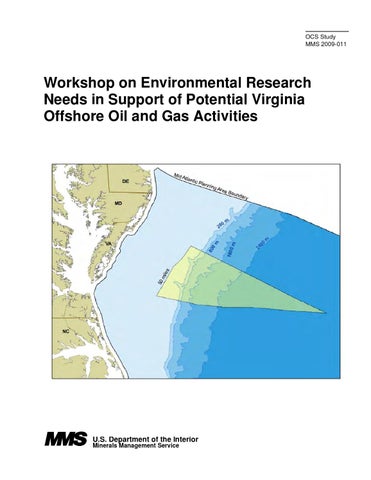
DISCLAIMER This report was prepared under contract between the Minerals Management Service (MMS) and the Virginia Institute of Marine Science. This report has been technically reviewed by the MMS and approved for publication. Approval does not signify that the contents necessarily reflect the views and policies of the Service, nor does mention of trade names or commercial products constitute endorsement or recommendation for use. It is, however, exempt from review and compliance with MMS editorial standards. REPORT AVAILABILITY Extra copies of the report may be obtained from the Public Information Office at the following address: U.S. Department of the Interior Minerals Management Service 381 Elden St. Herndon, VA 20170 Telephone Number: (703) 956-6593 CITATION Suggested citation: DĂaz, R.J., K.W. Able, L. Atkinson, D. Austin, R. Brill, S.D. Kraus, D. Lipton, and L.C. Schaffner. 2009. Workshop on Environmental Research Needs in Support of Potential Virginia Offshore Oil and Gas Activities. Final Report. OCS Study MMS 2009-011. U.S. Dept. of the Interior Minerals Management Service, Herndon, VA. 42 pp., plus Appendices. ABOUT THE COVER The graphic on the cover depicts that location of the potential lease sale area off the coast of Virginia within the Mid-Atlantic outer continental shelf planning area, which extends from Delaware to North Carolina.
ii
Workshop on Environmental Research Needs in Support of Potential Virginia Offshore Oil and Gas Activities List of Figures............................................................................................................................iv List of Tables..............................................................................................................................v Appendices .................................................................................................................................v Executive Summary....................................................................................................................1 Overview ....................................................................................................................................1 Workshop Objectives and Format ...............................................................................................2 Virginia OCS Description ...........................................................................................................3 Environmental Resources............................................................................................................3 Endangered and Protected Species ..........................................................................................4 Summary of Discussion Points ............................................................................................4 Knowledge Gaps for Endangered and Protected Species......................................................7 Pelagic and Demersal Fish and Fisheries.................................................................................8 Summary of Discussion Points ............................................................................................8 Knowledge Gaps for Fish and Fisheries...............................................................................9 Benthic and Biological Issues................................................................................................10 Summary of Discussion Points ..........................................................................................10 Knowledge Gaps for Benthos and Biology ........................................................................12 Physical and Geological Oceanography.................................................................................12 Summary of Discussion Points ..........................................................................................12 Knowledge Gaps for Physical and Geological Oceanography............................................13 Social and Economic Issues ..................................................................................................15 Summary of Discussion Points ..........................................................................................15 Knowledge Gaps for Social and Economic Issues..............................................................17 Workshop Recommendations....................................................................................................18 Physical and Geological Oceanography.................................................................................18 Fish and Fisheries .................................................................................................................19 Benthos and Biology .............................................................................................................20 Endangered and Protected Species ........................................................................................22 Socioeconomics ....................................................................................................................23 General Recommendations:...................................................................................................24 References ................................................................................................................................25
iii
List of Figures Figure 1. Figure 2.
Figure 3. Figure 4. Figure 5. Figure 6.
Figure 7.
Figure 8.
Figure 9. Figure 10. Figure 11. Figure 12. Figure 13. Figure 14. Figure 15.
Figure 16.
Federal outer continental shelf planning areas. General location of proposed Mid-Atlantic Area Lease Sale 220 off the coast of Virginia. Status of leases and other lease sales for the 2007-2011 period are also shown. Mid-Atlantic OCS planning area showing protraction areas and wells drilled from previous lease sales. Detailed location of Virginia OCS lease sale area within the Mid-Atlantic OCS planning area. Details of Lease Sale 220 area off the coast of Virginia. National Geophysical Data Center map encompassing much of the Virginia OCS lease sale area, Norfolk and Washington canyons are the prominent features, from: http://ngdc.noaa.gov/mgg/coastal/grddas02/grdden02.htm Survey effort for marine mammals and sea turtles in the Atlantic waters off of Virginia. Effort is given in kilometers of appropriately surveyed trackline mile per square kilometer of ocean (color code at bottom of image). The light blue shading around the lease site is a 20 mile buffer zone (see text of workshop report). Sightings of Turtles (Green, Leatherback, Loggerhead, Kemp’s Ridley, and Unidentified) in the Atlantic waters off of Virginia and around the proposed lease site. Sightings of North Atlantic Right, Humpback, and Sperm whales in the Atlantic waters off of Virginia and around the proposed lease site. Sightings of Blue, Fin, Minke, Sei, and unidentified Balaenoptera and Rorqual whales in the Atlantic waters off of Virginia and around the proposed lease site. Sightings of dolphins and pilot whales in the Atlantic waters off of Virginia and around the proposed lease site. Sightings of beaked whales in the Atlantic waters off of Virginia and around the proposed lease site. Oil spill cleanup after the Exxon Valdez (NOAA Photo). Shipping traffic density during two months in Hampton Roads, VA. Data courtesy Mark Swingle. Ambient noise levels from 0 to 1000hz in the Bay of Fundy right whale habitat are shown on the right. The intensity of noise from ships passing through the region (7 times) during a single 24 hour period is shown in color (red is loud, blue is quiet). For reference, a right whale upcall is shown at left in black and white, with scale matched to the ambient noise spectrogram. Note the frequency overlap between the call and the shipping noise. Images and data courtesy Chris Clark and Susan Parks. Ambient noise levels in a relatively pristine marine environment (left top) and in a highly urbanized one (right top). The lower graphs show that in the quiet ocean, finback whales provide the dominant low frequency noise, while in the urban one, finback sounds are completely masked by the ambient noise levels from human activities. Images and data courtesy Chris Clark.
iv
List of Tables Table 1.
Table 2. Table 3. Table 4.
Lease sale history of the Atlantic OCS Planning Area, see Figure 2 for area boundaries. Data summarize and rounded from: http://www.gomr.mms.gov/homepg/offshore/atlocs/atlleas.html#ATLOCSSALE Summary of the number Mid-Atlantic reports by major category. See Appendix C for details. Summary of physical and geological data needs for the Virginia OCS lease sale area. Summary of endangered and protected species concerns for the Virginia OCS lease sale area.
Appendices Appendix A. List of Atlantic BLM and MMS studies Appendix B. Workshop Agenda Appendix C. Workshop Attendees Appendix D. Workshop PowerPoint presentations
v
Workshop on Environmental Research Needs in Support of Potential Virginia Offshore Oil and Gas Activities Executive Summary The Minerals Management Service (MMS) has the responsibility for leasing and overseeing oil and gas development on the outer continental shelf. This oversight includes ensuring exploration and production are done in an environmentally responsible manner. In planning for a potential lease sale in the Mid-Atlantic outer continental shelf (OCS) Area offshore Virginia, MMS sponsored a workshop on the environmental research needs in support of potential Virginia offshore oil and gas activities 3 and 4 December 2008, in Williamsburg, Virginia. The focus of the workshop was to assess the existing scientific knowledgebase along the Virginia Coast and the information gaps that need to be addressed should a lease sale for oil and gas activities be held for the Virginia outer continental shelf. This report summarizes the outcome of the workshop. The first lease sales in the Mid-Atlantic region in the 1970s and 1980s lead to a series of environmental studies to collect baseline data on physical and biological conditions. These studies ranged from the Canadian border to Florida. Several were close to or included parts of the Virginia OCS within the planned lease sale. The principle recommendation from all breakout groups was to assess existing data in a thorough and systematic manner. This effort would include all MMS sponsored studies, other Federal and State agency reports and databases, and the peer-reviewed literature. This data assessment needs synthesize all disciplines. The exception may be socioeconomic, where there is little in the way of existing data to synthesis. New studies that focus on socioeconomics or monitoring could be started, but directed studies need to be informed by the results of the existing data synthesis. Given the complexity of the OCS and developing management strategies that focus on ecosystem based views of living and mineral resources, a cross-disciplinary effort between biology, fisheries, and physical studies is needed. It will be essential that synthesis efforts incorporate water column and bottom processes data. Geohazards also need to be integrated with the living resources data. Special attention needs to be given to the possibility of chemosynthetic organisms within the Virginia OCS lease sale area. MMS should develop a comprehensive and integrative plan to assess the cumulative impacts of multiple energy uses on the OCS and adjacent ocean areas. MMS should work with other relevant agencies, states and stakeholders to develop consistent standards to assess the geographic extent of potential impacts and the consequent range of requisite studies.
Overview The MMS, a bureau within the Department of the Interior, sponsored a workshop on the environmental research needs in support of potential Virginia offshore oil and gas activities 3 and 4 December 2008, in Williamsburg, Virginia. The focus of the workshop was to assess the existing scientific knowledgebase along the Virginia Coast and the information gaps that need to 1
be addressed should a lease sale for oil and gas activities be held for the Virginia outer continental shelf. This report summarizes the outcome of the workshop. The MMS has the responsibility for leasing and overseeing oil and gas development on the outer continental shelf (OCS). The OCS comprises the portion of the submerged seabed adjacent to all US coasts whose mineral estate is subject to Federal jurisdiction (Figure 1, MMS 2006). In addition, MMS’s oversight includes ensuring exploration and production are conducted in an environmentally responsible manner. The MMS is planning for a potential lease sale in the Mid-Atlantic OCS Area offshore Virginia (Figure 2). The Mid-Atlantic Planning Area, which extends from Delaware to North Carolina (Figure 3), encompasses approximately 112.83 million acres and has had the most lease sales (5), the largest number of leases awarded (238), and the most wells drilled (32 exploratory, 2 COST) (Table 1). The offshore Virginia lease sale (designated number 220) is scheduled for 2011 under the current OCS leasing Program 2007-2012 and will cover about 2.9 million acres starting 50 miles offshore Virginia (Figures 3, 4, and 5, http://www.mms.gov/5-year/). The Gulf of Mexico (GOM) MMS region will be responsible for administering the Atlantic OCS area. The GOM region is the largest and manages more than 7,000 active leases covering more than 39 million offshore acres, with over 3,850 producing and 200 drilling facilities for some 160 qualified operators. The Atlantic OCS area is divided into four planning areas along the Atlantic seaboard: the North Atlantic, Mid-Atlantic, South Atlantic, and the Straits of Florida (Figure 2). Between 1976 and 1983, nine oil and gas lease sales were held for the Atlantic OCS planning area. Straits of Florida was transferred from the Gulf of Mexico OCS Planning Area to the Atlantic OCS Planning Area in 1985 and has had only one lease sale (Lease Sale #5) in 1959 that resulted in three exploratory wells (Table 1). A total of 433 blocks were leased in all the Atlantic OCS lease sales and 49 exploratory wells and 5 COST wells were drilled. Within the Mid-Atlantic Planning Area 32 exploratory wells and two COST wells were drilled (Table 1, Figure 3). On November 17, 2000, the interests in the last remaining 8 natural gas and oil leases active in the Federal waters offshore North Carolina were relinquished by Conoco, Shell Offshore and OYX USA. The last oil and gas lease sale within the Atlantic Region occurred in 1983. On November 17, 2000, the interests in the last remaining eight natural gas and oil leases active in the Federal waters offshore North Carolina were relinquished. There are now no oil and gas leases in existence off the Atlantic Coast.
Workshop Objectives and Format The objectives of the workshop on environmental research needs in support of potential Virginia OCS oil and gas activities were to: • Review the status of the environmental and socioeconomic information for Virginia’s inner and outer continental shelf. • Develop recommendations for a coordinated plan of environmental and socioeconomic research need prior to oil and gas activities. • Explore for the potential of coordinated interdisciplinary and interagency research programs. 2
Emphasis at the workshop was directed toward assessing what is known and unknown within the area. The workshop format included presentations and breakout groups. Oral presentations by local and regional scientific experts in the areas of physical oceanography, fish and fisheries, marine mammals, socioeconomics and other relevant science topics of concern covered existing data and major environmental concerns. After the plenary presentations, attendees formed into disciplinary breakout groups and focused on identifying the key issues of concern should oil and gas activities occur off the coast of Virginia, and the important scientific information gaps that need to be addressed. The agenda for the workshop is in Appendix A and a list of attendees in Appendix B. Copies of the oral presentations are in Appendix C. The first of four breakout sessions was spent on discussing what is known and brainstorming where information gaps exist. Topics and gaps were discussed and framed in terms of being able to address key issues for future studies. The second session was spent prioritizing the ideas and studies. The third session was spent expanding on the one or two substantive ideas from each disciplinary group to provide background for potential studies, and information about what each study would be about and how it would be executed. The fourth session was spent preparing a brief summary that was presented to the entire workshop by the disciplinary facilitators. Emphasis was placed on MMS environmental information needs in planning for oil and gas activities on the Virginia OCS.
Virginia OCS Description Studies conducted in the Atlantic OCS Region (Figures 1and 2) from 1974 to 1995 have resulted in over 450 published reports. Of these about 200 reports related to the Mid-Atlantic OCS Area (Figure 2, Appendix D). Information on these studies and reports can be obtained from the MMS, Environmental Studies Program Information System (ESPIS): https://www.gomr.mms.gov/homepg/espis/espismaster.asp?appid=1 The majority of the Mid-Atlantic studies were baseline or benchmark studies, with many being the first systematic scientific studies of the inner and outer continental shelf along this area of the US Atlantic coast. Many were large-scale, multidisciplinary investigations designed to characterize the nature, abundance, and diversity of biological communities, the physical characteristics of the seafloor and overlying water column, and concentrations of certain trace metals and hydrocarbons in the water, sediments, and endangered species prior to OCS oil and gas activity (Table 2).
Environmental Resources Each of the disciplinary breakout groups reviewed what is known, identify gaps in our knowledge, and discussed datasets, reports and published works. Topics focused on being manageable and able to address issues in future environmental studies. The main considerations that the breakout groups were asked to consider fell into two categories: • Short term to support the upcoming lease sale. • Long-term, to meet future needs should oil and gas development occur. Possible funding partners identified as having an interest in the OCS included the following Federal agencies: National Science Foundation (NSF), Office of Naval Research (ONR), National Aeronautics and Space Administration (NASA), National Oceanographic Partnership 3
Program (NOPP), United States Geological Survey (USGS), National Oceanic and Atmospheric Administration (NOAA).
Endangered and Protected Species Facilitator: Scott D. Kraus The endangered and protected species group addressed the data gaps and issues pertaining to marine mammals, sea turtles, and sea birds in the waters of and around the potential Virginia OCS lease sale area.
Summary of Discussion Points Although there has been a substantial amount of survey effort, only a limited amount of it has occurred in the lease sale area (Figure 7). Survey effort is particularly low in the offshore portions. Most of the region-wide survey effort dates from the late 1970’s and early 1980’s, for example the Cetacean and Turtle Assessment Program (CeTAP). Subsequent surveys have been focused on areas of specific interest (i.e., Navy training ranges), and have not covered the entire region. The CeTAP surveys collected data on marine mammals and sea turtles (http://gcmd.nasa.gov/records/GCMD_seamap284.html) and most subsequent surveys have done the same. Some NMFS surveys were focused only on sea turtles. No surveys for pelagic birds have been conducted in the region, and data on their distribution and abundance is anecdotal. Most of this survey effort is also aerial. Both the effort data and sighting maps presented are cumulative maps of all data collected from 1979 to 2005. Data was not analyzed for seasonality, which would be required to evaluate the seasonal use patterns of this region by different species. Sightings Data The marine mammal and sea turtle data shows a high use of Atlantic waters of Virginia by multiple species of sea turtles and cetaceans (Figures 8 to 12). The maps show all documented sightings, but they have not been corrected for survey effort, so they do not represent an unbiased view of distribution. The lack of survey effort in most of the offshore region, and in specific areas inshore, means that sightings data shown here is biased according to where people looked. Sea turtle data was not separated by species, partly because species identifications from aircraft are difficult or impossible (except for leatherbacks). Figure 8 shows that sea turtles are found wherever surveys have been conducted. Sightings are reduced offshore, probably due to a lack of survey effort. All sea turtles are classified as endangered under the Endangered Species Act. As a general rule, right whales have been sighted in coastal waters (with a few exceptions at the shelf break), humpbacks have been seen on the shelf from shore to the shelf break, and sperm whale sightings are almost entirely found near the shelf break and in deeper waters (Figure 9). All of these generalizations are weakened by the lack of consistent survey effort throughout the region. Although the seasonality of humpback and sperm whales is not well known here, right whales probably occur from early-November to the end of April, as Virginia is a migratory path for right whales going to and from the winter calving ground off the southern U.S. Atlantic coast. All three of these species are classified as endangered under the Endangered Species Act, and right whales can be considered at risk of extinction due to human activities (Caswell et al., 1999; Fujiwara and Caswell, 2001). 4
Sightings of the balaenopterid whales are shown in Figure 10. With the exception of minke whales, all species are listed as endangered under the Endangered Species Act. Although all species of balaenopterids are included in this map, blue and sei whales are relatively rare in the region. Finback whales are fairly common, and are usually seen along the outer shelf and shelf break, with occasional sightings further offshore. Like the other species, these generalizations are weakened by the lack of consistent survey effort throughout the region. The seasonal distribution patterns for these species is not well known, although records include sightings from the region throughout the year. All dolphins, porpoises, and pilot whales are protected under the Marine Mammal Protection Act, but none are listed under the Endangered Species Act. The coastal assemblage in this region is composed primarily of the coastal bottlenosed dolphin (Tursiops spp), (Figure 11). The near shelf edge assemblage is dominated by pilot whales (Globicephala spp), striped, spotted, and spinner dolphins (Stenella spp.), Rissos dolphins (Grampus griseus), and common dolphins (Delphinus delphis). Like all cetaceans in this region, seasonal distribution and abundance patterns are not well known due to the lack of consistent survey effort throughout the region. Nevertheless, records include dolphin and pilot whale sightings throughout the year. All beaked whales are protected under the Marine Mammal Protection Act, but none are listed under the Endangered Species Act. All beaked whales are primarily deep-water species and their distribution is off the shelf edge in this region (Figure 12). Beaked whales are long divers (up to two hours) so they are frequently missed by surveys. Also, because they occur in the offshore portion of this region where survey effort is sparsest, information on seasonal distribution and abundance patterns is completely lacking. Potential Environmental Issues We classified the consequences of drilling activities into three categories relative to their potential to affect individual animals, localized groups of individuals, and stocks or populations. Three areas of concern included the discharges accidentally or chronically released during the course of drilling activities, increases in vessel traffic associated with both exploration and rig maintenance, and production activities, and underwater noise associated with seismic exploration, drill rig operations, and from associated vessels. Discharges The stereotypical concern of the American public with regard to offshore drilling is the catastrophic large-scale oil spill typified by 1989 Exxon Valdez disaster off the coast of Alaska (Figure 13). However, extensive advances in drilling technology and a lot of historical data from the Gulf of Mexico suggests that the probability of an oil spill from drilling operations is extremely low. There are other drilling related discharges, which require consideration, including drilling muds, rig waste, and air pollution. The direct consequences of these on marine mammals, sea turtles, and seabirds are likely to be low, with potential effects limited to a few individuals or local groups. This is not to say that the probability of damage is non-existent. As Geraci and St. Aubin (1990) have pointed out, “ When oil is drawn from the seabed or transported along oceanic routes, some 5
inevitably escapes.� However, for marine mammals, those at highest risk are fur-bearing animals (pinnipeds, polar bears, and sea otters). Only pinnipeds occur in this part of the Atlantic, and they are rarely found in the region. Manatees occasionally travel this far north, but tend to be coastal and rare, and are therefore unlikely to be at risk form discharges or spills. For cetaceans the data suggests that cutaneous exposure to oil, inhalation, and ingestion, have minor and/or temporary consequences (Geraci, 1990). With regard to the potential for baleen fouling, perhaps the most worrisome of the potential oil spill threats for large whales, the evidence indicates that these species have the potential to clear 95% of all oil within 24 hours of exposure. The final concern, the ingestion of the toxic chemicals associated with oil spills remains in need of further study, although preliminary information indicates some metabolic and de-toxifying capabilities in cetaceans (Geraci, 1990). Vessel Traffic Many scientific studies have been done to assess the role of speed in ship kills of large whales, and five studies have specifically evaluated this for right whales. Various studies (Vanderlaan and Taggart 2007, Pace and Silber 2005, Laist et al. 2001, Kite-Powell et al. 2007, Vanderlaan et al. 2008) used different analytical approaches, but all reached the same conclusion that vessel speed plays a role in the level of severity of a strike. In addition, Knowlton et al. (1998) concluded that in none of their simulations did a slower moving ship increase the risk of collision. A slower ship has lower hydrodynamic forces and is thus safer for a whale trying to take avoidance action. The cumulative results of these multiple studies are conclusive – no matter which technique is applied, increased shipping speed carries increased risk of death and serious injury to all large whales. The entrance to Chesapeake Bay is one of the busiest shipping areas along the East Coast, serving several commercial ports and military facilities (Figure 14). This high level of shipping crosses the migratory routes of right whales and probably humpbacks. All species of baleen whales have been reported killed by ships (Jensen and Silber 2004, Laist et al. 2001), and finbacks, humpbacks, and right whales are most frequently reported. Existing data suggests that vessel traffic out of the Chesapeake Bay area has been responsible for at least five right whale mortalities in the last 15 years (Knowlton and Brown, 2007). Vessel traffic associated with the lease site will be dependent upon the oil and gas activities (seismic, drilling, maintenance, and production) and how the site is eventually developed if oil or gas is found and transported. Nevertheless, all vessels over 65 feet in length will be subject to seasonal speed restrictions implemented by NOAA on December 9, 2008. Under 50 CFR Part 224, NMFS established regulations to implement speed restrictions of no more than 10 knots to reduce the likelihood of deaths and serious injuries to endangered North Atlantic right whales that result from collisions with ships. Noise Cetaceans live in an environment that at best has visibility of 200 ft, and in most ocean regions far less. They have therefore evolved into highly acoustic animals, using sound to find food, communicate, and in some cases to navigate. As human activities in the ocean have increased, noise from commercial and recreational vessels, sonars, seismic exploration, dredging, and construction have all increased dramatically. A large portion of this noise comes from vessel engines and propellers, and those sounds occupy the low frequencies used by most large whales. Acousticians have estimated that the chance of two whales hearing each other today has been 6
reduced to 10% of what it was 100 years ago (Parks and Clark, 2007) due to the masking of communication sounds by the ambient ocean noise created by multiple industrial activities (see Figure 15). Oil and gas development within the lease site will involve seismic exploration (loud, broadband low frequency pulses), hazards surveys sonar (mid-to high frequency pulses), drilling (low frequency broadband noise), and vessel traffic (loud broad spectrum sounds, frequency dependent upon the ship size). While some military sonars have been shown to cause deaths in beaked whales (by mechanisms that are still being studied), within the activities related to oil and gas development, only seismic exploration has the sound source levels that are capable of inflicting serious damage to cetaceans if suddenly exposed. Although there is no uncertainty that these noises are cumulatively affecting the ocean environment for cetaceans, there is some uncertainty about both the behavioral responses of cetaceans to many of these sounds and the population consequences of those sounds (National Research Council, 2005). Almost all animals within a broad region will be exposed to the sounds of seismic exploration. Human technology can detect seismic exploration across ocean basins, and there is ample reason to believe that many whale species can do as well or better. The subsequent activities are more likely to affect local groups of animals, although large shipping (if that proves to be the mode of transport) can create sounds audible from over 100 miles away. The cumulative impacts from all of these activities are adding to the ambient noise levels in the ocean and are steadily eroding marine mammal’s abilities to communicate (See Figure 16). At some point this acoustic smog (Clark et al., 2007) will start to affect the abilities of whales to find food and mates. When that happens (and that point may be near), human noise pollution in the oceans will have significant, long-lasting, population level consequences on the survival of some marine mammals. Because the bulk of human industrial sounds in the oceans are low frequency, it is likely that the large baleen whales will be those that will be affected first. Noise mitigation is possible, and there may be some seasonal restrictions that would minimize impacts on highly endangered species such as right whales. However, because of the potential for large-scale widespread impacts, underwater noise should be the primary consideration in environmental mitigation strategies around any leased sites in this region.
Knowledge Gaps for Endangered and Protected Species Data gaps have been identified throughout the previous sections and are summarized in Table 4. Care needs to be taken in synthesis of existing data as the quality and original sources of data need to be assessed. Thus caution is needed in using previous data synthesis efforts as there may be redundancy in the unpublished and gray data. Age of existing data could be an issue for mammals and turtles, as much of it is 20 to 30 years old. A comprehensive data inventory and synthesis from original sources for marine mammals, sea turtles, coastal and marine birds (pelagic & onshore) is needed. Included in this would be published peer-reviewed literature and various gray literature sources such as MMS reports (Appendix D), NMFS turtle surveys and stock assessment reports, and Navy surveys. Unpublished data held by States, universities-theses and dissertations, and NGOs also needs to 7
be included, for example, the Nature Conservancy, Virginia DEQ, National Marine Sanctuary proposal for Norfolk Canyon, Right Whale Consortium, UNCW, and Virginia Aquarium humpback data, VIMS sea turtle data. Finally, on-going studies that are yielding data of interest and not yet published should be included. Metadata file associated with these studies needs to look at season, geographic extent, etc. Seasonal and annual data are needed that include: • Passive acoustics for broad sounds to get all animals. For lifetime of the project. • Residents vs. migrants, sperm whales may be residents and fin whales migrants. • Joint industry program on noise needs to be integrated into other programs. • Controlled experiment with sonic tags. To see how animals behave when seismic work starts.
Pelagic and Demersal Fish and Fisheries Facilitators: Ken Able and Rich Brill There are several databases and many reports and publications that are relevant for assessing fish and fisheries in the proposed Virginia OCS lease sale area. These sources need to be reviewed and summarized. Efforts to summarize and synthesize these existing sources should be divided into two broad categories: short-term and long-term assessments. For example, fish migration patterns could be analyzed in the short-term with relevant existing National Marine Fisheries Service (NMFS) data. Information available in the NMFS database includes fish species and abundance, physical habitat mapping, seasonality, and vessel trip reports that include gear type, effort, etc. To meet future needs, should oil and gas development occur, longer-term studies of the fish situation at the shelf break, slope, and canyons would be needed as the data density declines further offshore at the shelf break and abyssal plain.
Summary of Discussion Points Synthesis of existing data should be the primary task. A number of fish and fisheries databases include at least part of the Virginia lease sale area. New surveys for canyons and upper slope habitats may be needed as these areas have not received as much sampling effort. The long-term nature of several datasets needs to be explored for patterns in fish populations. This would include examining many of the peer reviewed articles on fish and fisheries of the region. Published syntheses that used these databases, or are currently being conducted, have looked at fish migration and population dynamics, oilrig attraction, acoustic ecology, larval abundance, fisheries timing, location, effort, and landings. For example, the shelf wide Northeast Fisheries Science Center Oceanography Branch (NEFSC) EcoMon plankton survey (http://www.nefsc.noaa.gov/epd/ocean/MainPage/shelfwide.html) conducts six, shelf-wide plankton surveys per year and the ichthyoplankton data from more recent surveys (1999-present) are currently being added to NEFSC databases. Other examples relevant to specific areas of the Virginia area would be NMFS zooplankton database and the Norfolk Canyon shark database of the National Shark Research Consortium and Shark Research Program at the Virginia Institute of Marine Science (http://www.flmnh.ufl.edu/fish/sharks/nsrc/vims.htm). Particular attention needs to be given to analysis of toxic effects and hydrocarbon databases. This will address risks from drilling and also from spills.
8
A portion of the existing information contained in these databases may be outdated and will need to be updated with new focused studies. For example, how will climate change species distributions? Care will need to be taken in comparing fisheries information to ensure that techniques are comparable. Assessment of how differences in gear affect broad regional summaries may need to be done. An assessment of how relevant data collected from the other MMS regions, particularly the Gulf of Mexico for fish and fisheries impacts from oil and gas development needs to be conducted. Specific factors that need to be considered for fishes include population dynamics of various life stages. More data are needed on larval stages and spatial scales of egg distributions. Synthesis of existing data with some additional seasonal sampling linked with physical transport models will be required (cross linked with physical oceanography section). Temporal scales from shortterm to long-term patterns in fish abundance need to be assessed relative to the spatial scales of oil and gas development sites (for example, platform or pipeline) to larger scale effects (for example, circulation patterns). Impacts of seismic surveys on fishes must be specifically assessed, as most of the data on sound effects relates to marine mammals (see Endangered and Protected Species section). For fishes, what are the physiological effects from air guns, for example and are there other impacts that might affect fisheries? Particular attention needs to be given to species that may be most affected by oil and gas development, such as demersal fishes (excludes highly migratory pelagics), shellfish populations (crab, shrimp, scallops, etc.), highly localized species, and sharks. All of these groups include both commercially or recreationally important species.
Knowledge Gaps for Fish and Fisheries Currently there is little to no data on existing body burdens for oil and gas development related pollutants. This information is needed for key indicator species and should be monitored for both population and individual loads. Indicator species would include localized noncommercial species and commercial species (such as, tilefishes, mussels, lobsters, and red crabs). Some habitats within the Virginia lease sale area with limited information will require baseline studies, such as Norfolk and Washington Canyons. The ecosystems of canyons tends to be spatially diverse and complex and difficult to study, thus there is little know about the Middle Atlantic canyons. Similar focused studies would be needed for upper-slope (depth > 200 m) habitats. When and where fisheries occur will be a key factor to determine relative to the timing of seismic surveys and considerations for fishery windows similar to those used to minimize environmental disruption from other activities. Little is known about the acoustic ecology of fishes and what the impacts of sound production from seismic surveys are. Dock surveys for various aspects of recreational and commercial fisheries would be needed to establish baseline data on total value of the Virginia region and as a point for assessing change in fisheries shifts (cross linked with Socioeconomics section). Larval stages will have the most sensitivity to drilling muds and fluids. An assessment of data from the Gulf of Mexico region is needed to determine transferability of knowledge. Is Gulf of 9
Mexico, Pacific, and Alaska Regions information on fish attraction to oil and gas structures applicable in Mid-Atlantic Area? Do oil and gas structures result in more fishes or simply attract existing fishes and do these structures act as vectors for invasive species? Larval stages are also subject to oceanographic processes and interactions with major topographic features. How all these processes and factors influence larval transport needs to be determined. In particular, how the Gulf Steam interacts with other coastal circulations to affect larval transport of both regionally spawning fishes and invertebrates, as well as extra-regional larvae transported into the Virginia area.
Benthic and Biological Issues Facilitator: Linda Schaffner Little nonfisheries benthic and biological data are available for the Virginia OCS lease sale area. This area likely represents a “Transition Zone� between the influences of a colder temperature regime to the north (cold pool) and warmer Gulf Stream dominated North Carolina and Cape Hatteras shelf region to the south. It is well known that bathymetric and latitudinal gradients are important sources of variation over the OCS. The position of the Virginia OCS lease sale area within the broader region means it is subject to significant temperature variations at the shelf break and slope. Canyons intruding into the shelf area and other topographic features along the shelf-edge further increase the variation among shelf habitats. The deep-sea regions in the east of the Virginia OCS lease sale area are likely more constant and typical of other deep-sea regions.
Summary of Discussion Points The proposed lease area is small with the width of the western edge about 50-75 miles and tapers to a point to the east at a depth of 3000 m. The area also contains two canyons beyond the shelf break. The canyons represent unique habitat within the region and should be carefully evaluated and monitored for impacts from oil and gas activities. As with the other disciplines, the further offshore one goes the less information there is. In general, there have been a limited number of benthic and biological studies in the Virginia OCS lease sale area. Benthic information from the area is limited. There are a number of studies that have been conducted near or in part of the Virginia OCS lease sale area such as the BLM-OCS mid-Atlantic studies from the 1970-80s with data on the shallower shelf (Boesch et al., 1977 and Appendix D), MMS Manteo-Cape Hatteras study to the south (Blake and Diaz, 1994), general faunal surveys on the shelf and slope (Wigley and Theroux, 1981, Maciolek et al., 1987), and various NOAA reports. Fauna changes occur at Cape Hatteras and further south for the continental shelf. Changes in the fauna at slope depths also occur between Virginia and Hatteras. There is a large change in topography of the shelf and slope between Virginia and North Carolina. The Virginia OCS is not comparable with shelf fauna further to the north either. The Virginia OCS is more influenced by the warm Gulf Stream water and northern OCS by cold water pools. The outer shelf and shelf break are not well studied and poorly characterized. The Nature Conservancy has attempted to identify benthic habitat by developing a GIS mapping database, which includes USGS grab samples from the 1960s used to classify bottom habitats.
10
Key habitat or bottom types that need to be identified and inventoried include dispersed hard bottom such as clay, rocky shale or shelly outcrops; low and high topographic areas on the outer shelf and slope; and hard bottoms overlain with soft sediments. Habitat types with particularly low or high productivity need to be identified including what is below soft sediment veneers. An important component of locating and determining the aerial extent of various habitat types is detailed bathymetry. Currently NOAA’s National Geophysical Data Center (NGDC) has much of shelf area mapped at very coarse scales (see Figure 6 and http://ngdc.noaa.gov/mgg/coastal/grddas02/grdden02.htm for examples). The data that supports the NGDC maps needs to be assessed to determine the actual resolution and accuracy of the published maps. Any effort directed to new studies needs to be focused in areas of expected oil and gas activity and concentrate on the most important habitats. Inshore of the proposed sale area is a broader region that will need to be assessed for benthic resources. This broader region can be divided into five segments for the purposes of benthic biology: • Outer continental shelf from 3 to 50 miles offshore is about 40% of the total region. • Shelf break about 20%. • Slope about 10%. • Canyon area is <2%. • Deep-sea at eastern tip is about 30% Synthesis of existing data from other deep-sea areas should show the deep-sea is broadly homogeneous along the Atlantic coast and that the deep-sea portion of the proposed sale area should be given low priority for new sampling. Canyons will require special attention as they tend to support high diversity of large epifaunal species related to the spatial and vertical extent of hard bottom. Sampling design would need to consider the limited area that canyons occupy and adjust effort to insure the canyons are adequately sampled. There is a need to describe canyon ecosystems in order to determine their uniqueness and sensitivity to oil and gas activities, as they may be high priority areas for protection. Synthesis of existing data in the peer-reviewed and gray literature should be a primary task undertaken. This needs to include the large number of environmental studies and report supported by MMS (Appendix D). Before any synthesis takes place, MMS should develop scenarios as to how the existing data synthesis will be used. This will help to focus the effort on identification of data needs for future assessments. A workshop format with ecologists to discuss what is known, and how to prioritize and synthesize data is recommended. The flow of tasks would be for MMS to first develop scenarios for data needs and to identify who needs to be part of a synthesis team to attend a workshop. At a minimum, at least one experienced benthic ecologist for each major area segment would be needed (OCS, slope, and deep-sea). In addition, ecologists for benthic-pelagic coupling and physical oceanographers for physical-biological coupling would be needed. Second, the references and data should be compiled and synthesized by scientists who would present the findings at the workshop. The product from this workshop would be written as a peer-reviewed manuscript(s), which would be used to develop management tools for the area relative to oil and gas development.
11
There is a possibility that at the shelf break, rock outcrops and scarps may be present with unique community types. For example from New Jersey to North Carolina there are some deep reefbuilding organisms, and Lophelia spp. (deep water coral) may be present. Tile fish are present on hard substrate and clay bottoms. Geologically, ridge and swale topography is a prominent feature of the shelf in this area with sand waves as high as 10 m and wavelength of 10â&#x20AC;&#x2122;s of meters. These features are known to shape benthic community structure and can be seen at 50 m resolution.
Knowledge Gaps for Benthos and Biology One of the larger unknown questions is what are the latitudinal gradients along bathymetric contours and how does the Virginia OCS lease sale area compare to the rest of the OCS along the Atlantic coast? A first step to address this question would be mapping of benthic habitats to identify the extent and diversity of habitats that are present. This would include the use of broad scale multibeam and swath mapping for classifying sediment type and determining general patterns and distributions of habitat types. This effort would be combined with intermediate scale side scan sonar and Autonomous Underwater Vehicle (AUV) mapping to provide higher resolution of selected areas. Remote ground-truthing would be needed to identify high-priority areas and sentinel sites, e.g. for hard-bottom, high productivity swales. The focus of the groundtruthing effort would be on the outer shelf/shelf break area and use a diversity of approaches. Included would be AUV and sled video (long distances; collect data at regular intervals) methods. Point sampling with cameras and box-cores would be required for collection of sediments and fauna. At a minimum, the baseline sampling would be used to determine details of biotic communities including diversity, abundance and biomass. The sampling would also need to determine if the Virginia OCS is similar to the OCS to the north and south. Interpretation of benthic data would also rely on physical factors that regulate communities and species distributions such as differences in temperature or sediment supply (cross-linked with Physical and Geological section).
Physical and Geological Oceanography Facilitator: Larry Atkinson
Summary of Discussion Points There is a need to balance long- and short-term studies to accommodate the data required prior to the lease sale date. Prior to any lease sale, there needs to be an evaluation of data gaps. For geological issues, factors that need to be assessed included the extent of methane hydrates and bottom resuspension within the Virginia OCS region. Of particular relevance to the shelf topography are the extensive ridge and swale sand wave features. From a physical oceanographic perspective, how physical parameters associated with the Gulf Stream, and other broad regional circulation patterns, will influence and effect exploration needs to be understood. Other factors to assess would be the extent of offshore disposal of military waste (since World War I) as these sites would have to be located and identified as hazardous. Of particular importance would be to understand how the two canyons (Washington and Norfolk Canyons) and deep currents interact with other shelf processes. In addition, proposals for any pipeline route running from offshore to onshore need to be considered in light of the above physical and geological factors. Research and databases developed for alternative energy studies may be of benefit to oil and gas development and vice-versa. 12
Existing Mid-Atlantic MMS studies and data, plus those other agencies and peer-reviewed literature, should be synthesized in such a way that they inform and facilitate the design of additional studies. We recommend the literature review and analyses of existing data be organized around priority topics (for example, deep water boundary currents, permanent moorings; Rossby waves associated with Gulf Stream meanders and eddies). Consideration needs to be given for interests of other agencies who may wish to partner with MMS. For example, would the Commonwealth of Virginia or the Navy have any interest or resources? Also, are there deep current studies of the Gulf Stream or other Navy data that can be “unclassified?” For oil spill risk analysis, current and wind information are needed, is there sufficient data now or do we need more to properly map spills? Modeling is underway, and sea surface height anomaly, drifters, and circulation information are needed. This could be a high priority data gap. Synopsis of physical oceanography projects supported by other agencies and MMS (ESPIS website: https://www.gomr.mms.gov/homepg/espis/espismaster.asp?appid=1 and example peerreviewed citations): • SYNOP project off Cape Hatteras, Office of Naval Research (ONR) program - echo sounder study, look at variability of Gulf Stream and modeling, deeper water (Savidge and Bane, 1999). • High Energy Benthic Boundary Layer Experiment (HEBBLE) – BBL study under Gulf Stream. (Nowell and Hollister, 1985). • Physical Oceanography Program - Manteo Project of North Carolina in 1992, drifters, current, wind, water level data collection (Appendix D). • Study of physical processes in Mid-Atlantic Slope and Rise (MASAR) (Appendix D). • Frontal eddy dynamics (FREDY) study off NC, current meters, drifters, cross-shelf transport. Was prior to Manteo project (Glenn and Ebbesmeyer, 1994; Appendix D). • Data Assimilation and Model Evaluation Experiment (DAME´E), ONR program for ocean modeling Gulf Stream and then entire North Atlantic (Chassignet et al., 2000). • Shelf Edge Exchange Processes (SEEP), DOE program (Biscaye, 1994). • Dumpsite 106 studies for entire Atlantic Margin (Fry and Butman, 1991). • Ship “Oleander” – profiles from New York to Bermuda weekly time series (Rossby et al., 2005). • NOAA Coast Watch – Satellite remote sensing data source (http://coastwatch.noaa.gov/). • MARCOOS (NOAA), coastal ocean, data sets and time series, gliders and codar data (http://www.marcoos.us/). From the 1970s to today the questions addressed by these studies haven’t changed but the technology has. Satellite data is clearly an advancement and should be key to understanding physical and biological processes on the OCS.
Knowledge Gaps for Physical and Geological Oceanography The presence of Norfolk and Washington Canyons within the Virginia OCS complicate the physical and geological setting. How these canyons interact with local currents, general regional flows, and storms will be key to understanding sediment transport dynamics and resuspension. For example there is limited understanding of the effect of internal tides/waves and their 13
propagation/evolution on mixing and currents at the shelf break and canyon heads. Issues that need to be resolved with regard to deep near-bottom currents included their strength and variability and how turbidity is affected (background levels vs. what operations create). Seasonal variability in cross-shelf transport processes is also an important issue. In particular, how is the Benthic Boundary Layer (BBL) affected by hurricanes vs. Nor’easters, and “normal” events vs. larger-scale anomalies? The magnitude and frequency of events within the four defined environments (outer continental shelf, shelf break/slope, abyssal plain, and canyons) relative to bottom considerations, geological characterizations, and geohazards need to be viewed in a holistic way. This includes long-term cycles such as North Atlantic Oscillation (NAO) and other inter-annual variability effects. For many of these issues, satellite data will be a key asset. Nearshore processes, such as coastal currents, fronts and freshwater plums from Chesapeake and Delaware Bays, will also need to be assessed as they will play a large role in spill trajectories and movement of surface water layers. Models and studies relevant to transport of potential spills and what they might encounter and disturb, both environmental (microbes, blue crab larvae, fish spawning, etc.) and human impacts, needs to be cross-referenced to biological and fisheries concerns. Key areas for acquiring data for these models would include wind and other meteorological data in high resolution in time and space, and surface currents. All models need to be validated with recent observations. Ridge and swale topography is a prominent feature of Virginia OCS and how these topographic features interact with and influence transport and biological processes needs to be considered. For example, can ridge and swale topography change pollution transport, and what are the seasonal and storm induced movement implications and concerns for burying pipelines? This will be key to determining the appropriate depth of burial for pipelines to keep them below what could be exposed by movement of these features. Factors relative to the infringement of pipelines on the coastal environment and upland also need to be considered. Geographic Information System (GIS) linked databases need to be developed to improve visualization and data dissemination. GIS could also be the primary means of interfacing the science with management decisions. Geological and geophysical data models are needed for a few locations (2-6 sites/scenarios informed by observations – at least one model for the shelf, slope and abyssal plain) to cover the variability of the shelf/slope environments. These models would inform drilling locations and establish a range of possible scenarios. Datasets needed to combine into the GIS based models would include: • Bathymetry – A good example would be CARUMBA (Central Atlantic Region US Margin Basin Analysis: Central & North Atlantic; USA and Canadian Margin basins) a project to collect existing bathymetry data and put them into GIS format. • Grain size – spatial variability of sand vs. mud – scale of observations cross-shelf distribution. • Chemical/toxins – sediments and pore water. • Sediment/fauna interactions. • Drilling technology. • Thermal distribution related to above
14
Ideas were prioritized for three issues (oil spills, geohazards, and site specific impacts) and four environments of interest (shelf, slope, abyssal plain, and canyons), as summarized in Table 3. One study recommendation would be to set up a range of stations that exemplify two to six site types (including at least one per environment of interest) expected to occur within the lease area that explain the spectrum of sediment transport and bottom characterization. From these stations a range of scenarios can be tested. The variables to measure include, but not limited to, are: currents, sediment transport, and various other geological and physical oceanographic considerations relevant to drilling locations.
Social and Economic Issues Facilitators: Diane Austin and Doug Lipton There are a few socioeconomic studies along the Atlantic coast that pertain to oil and gas activities (Appendix D). Most socioeconomic studies that have been conducted are concentrated in the Gulf of Mexico and Alaska OCS regions.
Summary of Discussion Points The lack of information on the socioeconomic issues resulted in the breakout session focusing on key questions that would need to be addressed. The format of the discussion was therefore based on these questions rather than identification of existing information and future information needs. Will data gaps in social and economic issues have a bearing on permit process? Three-year permit process will provide opportunity to fill data gaps of concern to MMS. Without a pipeline terminating in Virginia, what is the potential economic positive for Virginia? Currently there is no lease-sharing revenue agreement with Virginia. What are the implications for not having a lease-sharing agreement to oil and gas development in the region? Leasing has almost always been an issue in Virginia from the first lease sales in the 1970s (Table 1). Virginia Beach wanted to restrict development to natural gas (not oil) due to tourist industry issues. What will be the regional impacts on Virginia employment and the net effect on Virginia due to oil and gas related infrastructure? Experience from the Gulf of Mexico region with increased traffic to bring in supplies to support oil and gas industries may be useful for decision-making in Virginia. What are the interactions of oil and gas, alternative energy development, and other activities? For example, would it be possible to develope a multiuse framework with other industries, such as offshore aquaculture. What are reasonable development scenarios comparing and contrasting the different energy sources? Incorporation of offshore wind studies and other energy development project might be a way of accommodating multiple users. There is a need to consider the cumulative impacts of all offshore activities. What are the economies of scope and most efficient use of resources on the OCS? There is a need to examine various options from no development to combinations of technologies. Possible interactions with military activity in the Virginia Capes area must be considered. Past and 15
current research on this needs to be summarized for possible hazards from military use, both environmental and economic impacts. What are the impacts of potential energy development on education, academic research, training, and development? Is there potential for new growth and centers of excellence? What are the effects of creating such centers that might draw people from beyond Virginia? How will potential offshore energy development affect existing relationships among local jurisdictions (Dillonâ&#x20AC;&#x2122;s Rule, Payne 2003)? How would tourism be affected by a new energy industry? Are there revenue-sharing models for localities and multi-state levels? Case studies should be developed for key areas. Decision support models that would aid local/state planners need to be identified. Consideration to impacts of growth and development from oil and gas activities on the land use and value need to be assessed along with watershed issues, and indirect effects on Chesapeake Bay and coastal waters. The potential impacts on port traffic and expansion of the Hampton Roads facilities needs to be accessed. How much port capacity do we have in local ports and can the additional vessel tieups be accommodated? What is the existing relevant labor force and what demographic implications will immigration of new workers bring? What is the existing transportation infrastructure and what are the potential impacts on that infrastructure of offshore development at each phase of that development? What are the environmental consequences of transportation expansion? Consequences to individuals and communities need to be considered. For example, what is the existing housing infrastructure and what are the potential impacts on that infrastructure of offshore development at each phase of that development? What are the potential impacts of decommissioning on the communities, workers, institutions, etc? What does the public think? Need independent surveys, risk perception study of coastal residents. A risk perception study prior to and following a revenue sharing model is needed. Need to define what questions are important for such surveys. What will be the impacts of offshore development on the price of natural gas regionally and nationally? What are the consumer benefits? Environmental concerns that have economic impacts (cross linked with Biology and Fisheries sections) would include the monetary value of potential ecosystem services impacts. What is the potential for spatial interactions and conflict with commercial and recreational fishing? What are the potential impacts of the possible importation of invasive species? Linking models of regional economy to appropriate environmental questions and watershed models is needed and would include spatial dimensions, coupled with land use. Hampton Roads Planning District has models that could be utilized in a case study. Fiscal effects should be addressed through a regional model. What are the state level fiscal benefits of the program? What are the benefits other than revenue? Differences in the spatial distribution of the program may affect State level fiscal benefits, the net impact on the State depends on where growth occurs. State level effects should be addressed first, then regional effects. What will the employment benefits be? Need for a baseline economic analysis with sufficient spatial granularity. 16
Knowledge Gaps for Social and Economic Issues What are the onshore socio-economic effects of reasonable estimates of offshore energy development for scenarios of no development, offshore oil and gas, offshore wind or other alternative energy sources, and both offshore oil and gas and wind? Issues of highest priority include potential impacts on transportation infrastructure, ports, housing, and commercial and recreational fishing. A risk perception study at two scales is needed with a case study of Hampton Roads and a broader regional study that would include residents from Cape May to Cape Hatters. Where oil and gas development will be based will be key to planning these studies. Will it be Hampton Roads, or will constraints and costs move it to other areas? Where onshore development is likely to occur in response to offshore development will need to be determined ahead of time to avoid expending effort in the wrong areas. The regional economic model should dovetail with what local planning districts are doing as much as possible. Costs and constraints of infrastructure development should be incorporated into the model. Information on land use changes is also a high priority. What are the threats/benefits to local economies (tourism, recreation, way of life, and fisheries) from onshore development, oil spills, increased ship traffic, and social structure and occupational shifts? Regional models should assess threats/benefits to local economies as well as consideration of existing state policies and interstate relationships. We identified three overarching themes that should apply to any socio-economic study: • Consider oil and gas in context of other offshore energy development. • Consider onshore infrastructure impacts. • Consider cumulative, long-term impacts. We identified four study topics that included: Fiscal effects of offshore development - Regional economic models should dovetail with what local planning districts are doing. Costs and constraints of infrastructure development should be incorporated into the models. Link models of regional economy to appropriate environmental questions and watershed models, couple with land use. Hampton Roads Planning District has models that could be utilized in a case study. Experience from development in Gulf of Mexico may provide data and examples that apply to Virginia decision-making. Spatial distribution of onshore development in response to offshore activities - Where is onshore development likely to occur in response to offshore development? What are the impacts of growth and development on the land itself relative to watershed issues, and what are the indirect effects on Chesapeake Bay and coastal waters? How would the industry impact port traffic and expansion of the Hampton Roads port? What is the existing transportation infrastructure and what are the potential impacts on that infrastructure of offshore development at each phase of that development? What are the environmental consequences of transportation expansion? What is the existing housing infrastructure and what are the potential impacts on that infrastructure of offshore development at each phase of that development?
17
Public perceptions of risks and benefits of offshore development - Include residents from Cape May to Cape Hatters. There is a need for risk perception study prior to and following a revenue sharing model. Need to define what questions are important for such surveys. Threats/Benefits to local communities - What are the impacts of potential energy development on education, academic research, training, and development? What is the existing relevant labor force and what demographic implications will immigration of new workers bring? What is the potential for spatial interactions with commercial and recreational fishing? Other issues to consider would include the possible interactions with military activity in the Virginia Capes area, potential impacts of decommissioning on the communities, workers, and institutions. What will be the impacts of offshore development on the price of natural gas?
Workshop Recommendations Physical and Geological Oceanography Synthesis, mining, and reanalysis of existing data and databases are needed in order to understand the current state of knowledge regarding physical and geological processes within the Virginia OCS lease sale area. The synthesis and interpretation would be central to planning new environmental studies. For the entire water column, transport processes, temperature, salinity, and density (with seasonal considerations) need to be characterized with specific consideration for: • Coastal fronts and estuarine interactions. • Cross and along shelf processes (cold pools, upwelling/downwelling, storm events, tides). • Shelf break processes, including seasonal stratification issues, Ekman transport, eddies and Gulf Stream, internal tides, and wind waves. • Up and down canyon flows and forcing factors. • Upper and lower layer interactions over the slope for the Deep Western Boundary Current (DWBC), topographic Rossby Waves (TRW), and Gulf Stream meanders and eddies. • Climate trends including North Atlantic Oscillations (NAO). For geologic and bottom processes, physical properties and distributions of sediment types on the shelf, slope, rise, and canyon need to be characterized with specific consideration for: • Cross and along shelf transport. • Sediment resuspension and dynamics. • Bottom Boundary Layer (BBL), effects of stratification and instability. • Slope and canyon wall stability and failure history. • Acoustic bottom mapping with multibeam and sidescan. • Methane seeps, gas hydrates, shallow gas deposits, and other geohazards. • Paleochannels, shallow flow zones, past transport pathways (high resolution shallow seismic). • Basin floor fan evolution.
18
Multi-disciplinary synthesis of physical oceanography and biological data to identify areas of high productivity or essential habitat. Integration of data and concerns from other disciplines is necessary with specific consideration for: • Coastal fronts and channels relative to marine mammal feeding, migration, and gathering areas. • Ridge and swale topography influence on physical and biological processes. • Shelf break winter and summer processes. • Canyon head. • Slope sea and eddy Studies that will require new observations and modeling: • Deep current energy – trapped waves and possible sites of energy intensification, currentRossby/topographic wave interactions. • Canyons – unusual currents, upslope/downslope flow, warm ring interaction affecting cross isobath transport. • Sediment dynamics studies – specifically on the slope and fan. • Detailed survey of geohazards - methane venting, shallow gas. • Mapping of seeps with interdisciplinary considerations (chemo-synthetic organisms, etc).
Fish and Fisheries Synthesis, mining, and reanalysis of existing data and databases are needed in order to understand the current state of knowledge regarding fish and fisheries within the Virginia OCS lease sale area. The synthesis and interpretation would be central to planning new environmental studies. For fish and fisheries, the key elements of this synthesis need to specifically consider seasonal distributions of historical and extant finfish and shellfish fisheries. Distributions and reproduction of fishes and shellfishes in the Mid-Atlantic Bight from Cape Lookout to Cape Cod and from the shoreline to abyssal plain needs to be considered. Extant databases include those managed by NMFS, Mid-Atlantic Fishery Management Council, state agencies, and The Nature Conservancy. In particular, Essential Fish Habitat (EFH) characterization including managed species, prey species, and their habitat need to be included. Environmental studies and knowledge from the Gulf of Mexico, Pacific, Alaska, and other oil and gas producing areas, for example Nova Scotia or North Sea, needs to be evaluated for possible application to impacts of oil and gas exploration and drilling and transport of and on the Virginia coast. There are broad areas of overlap between fish and fisheries and other disciplines data needs: • Passive acoustics as sampling methods and cumulative impact of sound pollution on fishes (Endangered and Protected Species). • Linking oceanography and biology with bottom and water column currents, and temperature (physical and geological). • Habitat mapping (Benthic and Biological). • Trophic interactions with birds, marine mammals, benthic and pelagic fishes, and invertebrates (Biological, Endangered Species). • Space-use conflicts with port-space and fishing areas (Socioeconomic). • Techniques for visualizing and managing information (all disciplines). 19
Studies are needed to address knowledge gaps in the finfish and shellfish fauna and fisheries especially for the upper slope and canyon habitats. In particular there is a need to characterization EFH within the Virginia OCS lease sale area for managed species and their prey species, and to determine baseline contaminant loading in key commercial species, such as scallops, tilefish, red crabs, and goosefish. The potential for drilling infrastructure (e.g., pipeline, platform) to facilitate invasive species and adjacent fauna to establish residency also needs to be evaluated. Rationale for and focus of these studies would be to assess changing environmental conditions and management strategies, and their effects on fishing techniques and target populations. Fish and fisheries need to be viewed in an ecological framework that includes both ecological processes and climate change factors. This approach would best inform MMS for EFH and other consultations. Baseline data to evaluate potential impacts over time must be collected prior to any oil and gas activities.
Benthos and Biology Synthesis, mining, and reanalysis of existing data and databases are needed in order to understand the current state of knowledge regarding biological conditions within the Virginia OCS lease sale area. The synthesis and interpretation would be central to planning new environmental studies. Before any synthesis takes place, MMS should develop scenarios as to how the synthesis will be used. Formation of a synthesis team of interdisciplinary scientists with information exchanged in a workshop format is recommended. The synthesis team would review and synthesize existing reports and data. MMS would first provide scenarios to the team as guidance with team members working with existing data in advance of meeting. Areas of focus would include: • Spatial and temporal distributions - effects of bottom type, temperature regimes (latitudinally, bathymetric regimes). • Potential impacts and effects - lessons learned from other regions and stressors. • Information could be used to develop management tools. • Products would be directed to peer-reviewed literature Rationale for this approach is to examine the diverse sources of information as early as possible to provide focus for future investigations and better understanding of environmental risks. This effort could lead to the development of a database management approach that is based on GIS tools which will be essential for visualizing and conveying information to agencies and the public. Studies are needed to address knowledge gaps in the biological and benthic processes especially to identify the location and extent of key high priority or unique habitats, such as those associated with high productivity (swales) or high biodiversity (hard bottom). Sampling effort would be stratified based on biotic zonation and areas of likely exploration impacts and with consideration of any pipeline pathway. Broad scale bathymetric mapping would be necessary for stratifying the area (coarse maps may already be available). Detailed mapping of select high priority habitats using acoustic, video, and photographic techniques will be needed. Groundtruthing and baseline data for megafauna, macrofauna, and other biogenic features need to be 20
collected prior to the start of oil and gas activities. The products should be primarily directed at the peer-reviewed literature and development of management tools such as GIS databases. Following guidelines used in the Gulf of Mexico Region, unique biological communities should be protected areas for drilling. Consideration of buffer zones is needed to lessen the influence of development activities. In addition, improvements in oil development technology have reduced the footprint of impacts, therefore data synthesis efforts as well as new studies need to be informed by more recent environmental studies and technologies. There is little data available for the Virginia OCS lease sale area for benthic resources. This area likely represents a “transition zone” between major biogeographic provinces and thus may contain unique faunal associations. It is situated in an area of significant topographic complexity in the transition from shelf to deep slope, which likely influences the area’s biology. Outline for a Benthic Study A benthic mapping effort would be key to planning any new environmental studies of the bottom. Approximate distribution of effort in each of three major habitat areas would be: • Shelf break (~50%) • Outer shelf (~25%) • Slope (~25%) Canyons would be included in the sampling for the shelf break as this is where canyon heads are located. Study metrics would include indicator species such as sea scallops, which can be surveyed photographically, amphipods, and echinoderms. A metric would need to be developed for offshore and deep-sea habitats specific to oil and gas activities similar to other coastal indices used in assessing benthic habitat conditions (for example see Weisburg et al., 1997 or Diaz et al., 2004). Metrics reflect critical importance of macrobenthos in assessing conditions of biodiversity, structure and sensitivity at the community level, and would function as indicators of sensitivity to environmental change at individual species and major taxa group levels. Abundance and biomass reflect the productivity regime and level of disturbance and would be measured as biomass per individual and depth distribution of biomass. An assessment would need to be made to determine if full community studies versus selected components would be required. As species diversity is high in deep water and slope areas, diversity metrics will be important in assessing benthic conditions including habitat stability and degree of disturbance. Various methods for measuring deep-sea diversity should be explored. Meiofauna and microbes would have a lower priority as they are small and more difficult to work with. But genomics may provide methods to make studies practical as baseline measurements. These groups could provide evidence of significant disturbance. Details of the study plan would include a stratified/random approach with directed sampling of key habitats. Acoustic mapping/backscatter analysis would be needed to identify hard bottom and other OCS features such as sand ridges. For specific habitats (topographic lows, canyons,
21
hard bottom) rapid assessment technique (sled, video) would be used to characterize, but sediment samples would still be needed to adequately characterize habitats. The deep-sea region is a small fraction of the Virginia OCS lease sale area and would require only a few samples. Data from surrounding deep areas will likely be able to characterize the Virginia OCS lease sale area as the deep-sea has the least likelihood of spatial variability and is relatively a small area. Visual surveys (video/photographic) would be used to quantify megafauna (echinoderms, anemone, crustacean, fish), biogenic structures to characterize function of community, and physical characteristics of the bottom would provide crude estimates of fluxes (turbidity, suspended particles). Visual surveys would also be used as ground truthing for multibeam and would require good geo-position data.
Endangered and Protected Species There may be a significant amount of un-synthesized extant and developing data that could provide a foundation from which to develop preliminary assessments and research work plans for the region. It is important that these data sources be synthesized, mined, and reanalyzed in order to understand the current state of knowledge regarding endangered and protected species within the Virginia OCS lease sale area. A data inventory and synthesis would be developed for marine mammals, sea turtles, and coastal and marine birds (pelagic and onshore). Included would be on-going studies that are yielding data of interest (not yet published). Metadata files associated with studies need to be analyzed to look at season, geographic extent, etc. All products should be in a GIS database management system for data visualization and integration of all data streams. New scientific surveys would be needed that are a combination of methods including: • Shipboard - separate protocols for marine mammals, seabirds, and sea turtles, adaptive sampling with line transect approach. • Aerial - restricted to sea turtles and marine mammals, high definition photography as a possibility for birds. • Passive acoustics - broad spectrum (in terms of frequency sensitivity) pop-ups or equivalent, capable of detecting whales, dolphins and specifically beaked whales. • Platforms of opportunity - train and place professional observers on whale watches, shelfedge fishing charters, seismic vessels, rig service vessels, and other opportunities. Studies would have to be multi-year to examine temporal trends and seasonal differences. All seasons and at least three years within the lease triangle plus a buffer area that would extend to shore would be required. Data would need to be collected pre-, during-, and post-seismic and drilling activity. Methods to assess residency in sperm whales, humpbacks, beaked whales, right whales, selected dolphin species, and sea turtles using photoidentification, tagging specifically for turtles, and genetics need to be implemented. Rationale for initiation of new surveys is that most sightings and distribution data is 20-30 years old, and may not be relevant to contemporary patterns. In addition, there is little or no survey effort beyond 50 miles, i.e., most of the lease site. There is an urgent need to identify the seasonal distribution and abundance patterns of most endangered and protected species in the lease region before activities are started. 22
A passive acoustic buoy array should be setup and maintained for the life of the project. In the first year, a baseline would be established with continued monitoring after seismic begins for at least two years. Baseline data on frequency of occurrence of different species and communication signals would also be collected. Species-specific hearing ranges and seasonality of species of concern would be documented to evaluate mitigation options with regard to seasonality of presence and activities for right, humpback, sperm and beaked whales, and sea turtles. Part of the data synthesis would integrate results from the Joint Industry Program (JIP) and determine what activity produces 180-200Db noise. Behavioral responses to seismic noise needs to be documented for the species of interest mentioned above. For the entire Mid-Atlantic Planning Area, there is an opportunity to conduct a study comparing responses of naïve animals in this area with data from Gulf of Mexico Region mammal studies. Rationale for these studies is that effects of noise from seismic and operational activities on marine mammals and seas turtle have only been studied in a few species. Because of the multispecies assemblage that occupies the lease sale area, careful monitoring and planning will be required to mitigate negative impacts on a broad array of endangered species. Species of particular concern include right whales, humpbacks, beaked whales, finback whales, and sperm whales. Data on sea turtle responses to these sounds is sparse as well. A multi-pronged approach is recommended as described above. There is significant overlap between endangered species and physical oceanographic data needs. A study that integrates the oceanography of the region with the presence of endangered species and other key resource species should be considered. In other areas, researchers have been developing such methods to predict the likelihood of a particular species present based upon seasonal oceanographic conditions. Finally, we wanted to acknowledge that in spite of our focus on the lease sale area and the waters between the area and the Virginia coast, there is the potential for larger scale impacts. Those broader impacts are certain to involve noise production related to seismic activity, and however small the potential for oil spills may be, should one occur, it’s effects will probably extend outside of the Virginia region.
Socioeconomics In regard to socioeconomics, it is important that realistic scenarios for what will happen within the Virginia OCS lease sale area be developed. Overall, there is little data to assess specific or broader impacts on the economy and communities of the region. States and local planners need to know what will happen to their communities relative to oil and gas activities. What is the distribution of impacts within region expected to be? Is there a need to consider a synergistic view with other activities like wind power, navy actives? Studies are needed to develop socioeconomic models to assess public perceptions of risk and benefits, developing a baseline of opinions now which tracks into the future. Three overarching themes that should apply to any socioeconomic study include: • Consider oil and gas in context of other offshore energy development. • Consider onshore infrastructure impacts. 23
•
Consider cumulative, long-term impacts.
Recommended socioeconomic studies include: • Fiscal effects of offshore development. • Spatial distribution of onshore development in response to offshore activities. • Public perceptions of risks and benefits of offshore development. • Threats and benefits to local communities.
General Recommendations: The principle recommendation from all breakout groups was to assess existing data in a thorough and systematic manner. The exception was socioeconomic, where there is little in the way of existing data to synthesis. This data assessment needs to incorporate all disciplines. New studies that focus on monitoring could be started immediately, but directed studies need to be informed by the results of the existing data synthesis. A cross-disciplinary effort between biology, fisheries, and physical studies is needed. It will be essential that synthesis efforts incorporate water column and bottom processes data. Evidence for slope failure, methane seeps and other geohazards also needs to be integrated with the living resources data. Special attention needs to be given to the possibility of chemosynthetic organisms within the Virginia OCS lease sale area. Given the complexities of OCS ecosystem, MMS should develop a comprehensive and integrative plan to assess the cumulative impacts of multiple energy uses on the OCS and adjacent ocean areas. MMS should work with other relevant agencies, states and stakeholders to develop consistent standards to assess the geographic extent of potential impacts and the consequent range of requisite studies. In particular, MMS should work with NMFS to identify issues with non-energy uses of the OCS such as offshore aquaculture.
24
References Biscaye, P.E. 1994. Shelf edge exchange processes in the Southern Middle Atlantic Bight: SEEP-II. Deep-Sea Research Part II 41:229-230. Blake, J.A. and R.J. Diaz. 1994. Input, accumulation and cycling of materials on the continental slope off Cape Hatteras: An introduction. Deep-Sea Research II 41:707-710. Boesch, D.F., J.N. Kraeuter, and D.K. Serafy. 1977. Distribution and Structure of Communities of Macrobenthos on the Outer Continental Shelf of the Middle Atlantic Bight: 1975–1976 Investigations. Virginia Institute of Marine Science Special Report in Applied Marine Science and Ocean Engineering, no. 175. Caswell, H., M. Fujiwara, and S. Brault. 1999. Declining survival probability threatens the North Atlantic right whale. Proceedings of the National Academy of Sciences 96:3308–3313. Chassignet, E.P., H. Arango, D. Dietrich, T. Ezer, M. Ghil, D.B. Haidvogel, C.-C. Ma, A. Mehra, A.M. Paiva, and Z. Sirkes. 2000. DAME´E-NAB: the base experiments. Dynamics of Atmospheres and Oceans 32:155–183. Clark, C.W., D. Gillespie, D.P. Nowacek, and S.E. Parks. 2007. Listening to Their World: Acoustics for Monitoring and Protecting Right Whales in the Urbanized Ocean. Pp. 333357 In: Kraus, S.D. and R.M. Rolland (Eds.) 2007. The Urban Whale: North Atlantic Right Whales at the Crossroads. Harvard University Press. Cambridge, Massachusetts. 543 p. Diaz, R.J., M. Solan, and R.M. Valente. 2004. A review of approaches for classifying benthic habitats and evaluating habitat quality. Journal of Environmental Management. 73:165– 181. Fry, V.A. and B. Butman. 1991. Estimates of the seafloor area impacted by sewage sludge dumped at the 106-mile site in the mid-Atlantic bight. Marine Environmental Research 31:145-160. Fujiwara, M. and H. Caswell. 2001. Demography of the endangered North Atlantic right whale. Nature 414:537–541. Geraci, J.R. 1990. Physiologic and Toxic Effects on Cetaceans. Chapt. 6 In: Geraci, J.R. and D.J. St. Aubin (eds). Sea Mammals and Oil: Confronting the Risks. Academic Press. 282 p. Geraci, J.R. and D.J. St. Aubin. 1990. Summary and Conclusions. Chapt. 12 In: Geraci, J.R. and D.J. St. Aubin (eds). Sea Mammals and Oil: Confronting the Risks. Academic Press. 282 p.
25
Glenn, S., and C. Ebbesmeyer. 1994. The structure and propagation of a Gulf Stream frontal eddy along the North Carolina shelf break. Journal of Geophysical Research 99(C3), 5029-5046. Jensen, A.S. and G.K. Silber. 2004. Large Whale Ship Strike Database. NOAA Technical Memorandum NMFS-OPR Kite-Powell, H.L., A.R. Knowlton, and M. Brown. 2007. Modeling the effect of vessel speed on Right Whale ship strike risk Project report for NOAA/NMFS Project NA04NMF47202394. Knowlton, A.R. and M.W. Brown. 2007. Running the Gauntlet: Right Whales and Vessel Strikes. Pp. 409- 435 In: Kraus, S.D., and R.M. Rolland (Eds.) 2007. The Urban Whale: North Atlantic Right Whales at the Crossroads. Harvard University Press. Cambridge, Massachusetts. 543 p. Knowlton, A. R., F.T. Korsmeyer, and B. Hynes. 1998. The hydrodynamic effects of large vessels on right whales: Phase two. NMFS Contract No. 46EANF60004 Kraus, S.D., M.W. Brown, H. Caswell, C.W. Clark, M. Fujiwara, P.K. Hamilton, R.D. Kenney, A.R. Knowlton, S. Landry, C.A. Mayo, W.A. McLellan, M.J. Moore, D.P. Nowacek, D.A. Pabst, A.J. Read, and R.M. Rolland. 2005. North Atlantic right whales in crisis. Science 309:561-562. Laist, D.W. A.R. Knowlton, J.G. Mead, A.S. Collet, and M. Podesta. 2001. Collisions between ships and whales, Marine Mammal Science, 17(1):35-75 Maciolek, N., et al. 1987. Study of the Biological Processes on the U.S. Mid-Atlantic Slope and Rise. Vol. 2, Final Report. (OCS Study MMS 87-0050). U.S. Department of the Interior, Minerals Management Service, Washington, DC. Minerals Management Service. 2006. Assessment of undiscovered technically recoverable oil and gas resources of the nationâ&#x20AC;&#x2122;s outer continental shelf. MMS Fact Sheet RED-200601b. 6 p. National Research Council. 2005. Marine Mammal Populations and Ocean Noise. The National Academies Press. 126 p. Nelson, M., M. Garron, R. L. Merrick, R. M. Pace III, and T.V.N. Cole. 2007. Mortality and Serious Injury Determinations for Baleen Whale Stocks along the United States Eastern Seaboard and Adjacent Canadian Maritimes, 2001-2005. Northeast Fisheries Science Center Reference Document 07-05. Nowell, A.R.M. and C.D. Hollister. 1985. Deep ocean sediment transport â&#x20AC;&#x201D; Preliminary results of the high energy benthic boundary layer experiment. The objectives and rationale of HEBBLE. Marine Geology 66:1-11. 26
Pace, R.M. and G. Silber. 2005. Simple analyses of ship and large whale collisions: Does speed kill? Sixteenth Biennial Conference on the Biology of Marine Mammals, San Diego, CA. Parks, S.E. and C.W. Clark. 2007. Acoustic Communication: Social Sounds and the Potential Impacts of Noise. Pp. 310-332 In: Kraus, S.D. and R.M. Rolland, (Eds.) 2007. The Urban Whale: North Atlantic Right Whales at the Crossroads. Harvard University Press. Cambridge, Massachusetts. 543 p. Payne, K.F. 2003. The entrepreneurial powers of local government: Dillon's Rule revisited. 2003. Electronic Doctoral Dissertations for UMass Amherst. Paper AAI3110542. Rossby, T., C.N. Flagg, and K. Donohue. 2005. Interannual variations in upper-ocean transport by the Gulf Stream and adjacent waters between New Jersey and Bermuda. Journal of Marine Research 63:203-226. Savidge, D. and J. Bane Jr. 1999. Cyclogenesis in the deep ocean beneath the Gulf Stream, 1. Description. Journal of Geophysical Research 104(C8):18111-18126. Vanderlaan, A.S.M and C.T. Taggart. 2007. Vessel collisions with whales: The probability of lethal injury based upon vessel speed. Marine Mammal Science 23:144–156. Vanderlaan, A.S.M., C.T. Taggart, A.R. Serdynska, R.D. Kenney, and M.W. Brown. 2008. Reducing the risk of lethal encounters: vessels and right whales in the Bay of Fundy and on the Scotian Shelf. Endangered Species Research 4:283–297. Weisberg, S.B., J.A. Ranasinghe, D.M. Dauer, L.C. Schaffner, R.J. Diaz and J.B. Frithsen. 1997. An estuarine benthic index of biotic integrity (B-IBI) for Chesapeake Bay. Estuaries 20:149-158. Wigley, R.L. and R.B. Theroux. 1981. Atlantic Continental Shelf and Slope of Faunal Composition and Quantitative Distribution. U.S. Geological Survey Professional Paper 529-N, pp. 1–198.
27
Figure 1.
Federal outer continental shelf planning areas.
28
Figure 2.
General location of proposed Mid-Atlantic Area Lease Sale 220 off the coast of Virginia. Status of leases and other lease sales for the 2007-2011 period are also shown.
29
Figure 3.
Mid-Atlantic OCS planning area showing protraction areas and wells drilled from previous lease sales.
30
Figure 4.
Detailed location of Virginia OCS lease sale area within the Mid-Atlantic OCS planning area.
Figure 5.
Details of Lease Sale 220 area off the coast of Virginia. 31
Figure 6.
National Geophysical Data Center map encompassing much of the Virginia OCS lease sale area, Norfolk and Washington canyons are the prominent features, from: http://ngdc.noaa.gov/mgg/coastal/grddas02/grdden02.htm
32
Figure 7.
Survey effort for marine mammals and sea turtles in the Atlantic waters off of Virginia. Effort is given in kilometers of appropriately surveyed track line mile per square kilometer of ocean (color code at bottom of image). The light blue shading around the lease site is a 20 mile buffer zone (see text of workshop report).
33
Figure 8.
Sightings of Turtles (Green, Leatherback, Loggerhead, Kempâ&#x20AC;&#x2122;s Ridley, and Unidentified) in the Atlantic waters off of Virginia and around the proposed lease site.
Figure 9.
Sightings of North Atlantic Right, Humpback, and Sperm whales in the Atlantic waters off of Virginia and around the proposed lease site.
34
Figure 10.
Sightings of Blue, Fin, Minke, Sei, and unidentified Balaenoptera and Rorqual whales in the Atlantic waters off of Virginia and around the proposed lease site.
Figure 11.
Sightings of dolphins and pilot whales in the Atlantic waters off of Virginia and around the proposed lease site.
35
Figure 12.
Sightings of beaked whales in the Atlantic waters off of Virginia and around the proposed lease site.
Figure 13.
Oil spill cleanup after the Exxon Valdez (NOAA Photo)
36
Figure 14.
Shipping traffic density during two months in Hampton Roads, VA. Data courtesy Mark Swingle.
37
Figure 15.
Ambient noise levels from 0 to 1000hz in the Bay of Fundy right whale habitat are shown on the right. The intensity of noise from ships passing through the region (7 times) during a single 24 hour period is shown in color (red is loud, blue is quiet). For reference, a right whale upcall is shown at left in black and white, with scale matched to the ambient noise spectrogram. Note the frequency overlap between the call and the shipping noise. Images and data courtesy Chris Clark and Susan Parks.
38
Figure 16.
Ambient noise levels in a relatively pristine marine environment (left top) and in a highly urbanized one (right top). The lower graphs show that in the quiet ocean, finback whales provide the dominant low frequency noise, while in the urban one, finback sounds are completely masked by the ambient noise levels from human activities. Images and data courtesy Chris Clark.
39
Table 1.
Lease sale history of the Atlantic OCS Planning Area, see Figure 2 for area boundaries. Data summarize and rounded from: http://www.gomr.mms.gov/homepg/offshore/atlocs/atlleas.html#ATLOCSSALE
Sale Sale Tracts No. Date Offered North Atlantic 42 12/79 116
Acres Offered
Bids
Tracts Leased
Acres Leased
660,000
189
63
359,000
816,000,000
8
154 109 253 155 4,050 4,721
877,000 620,000 1,440,000 882,000 22,665,000 26,485,000
410 74 240 19 53 796
93 39 51 18 37 238
529,000 222,000 290,000 102,000 211,000 1,355,000
1,128,000,000 40,000,000 324,000,000 4,000,000 68,000,000 1,564,000,000
27 1 4 0 0 32
South Atlantic 43 03/78 224 RS-2 08/82 232 78 07/83 3,582 Subtotal 4,323
1,275,000 1,321,000 20,156,000 24,374,000
99 9 12 240
43 8 11 109
245,000 46,000 63,000 621,000
101,000,000 3,000,000 13,000,000 460,000,000
6 0 0 6
80
458,000
23
23
132,000
2,000,000
3
Total All Sales 9,240
52,000,000
1,248
433
2,467,000
2,842,000,000
49
Mid-Atlantic 40 08/76 49 02/79 59 12/81 RS-2 08/82 76 04/83 Subtotal
Straits of Florida 5 05/59
Table 2.
Total Value
Exploratory Wells
Summary of the number Mid-Atlantic reports by major category. See Appendix C for details. Number 43 13 10 14 31 5 19 22 34 16
Category Information and Data Summaries Socioeconomics Onshore Impacts and Industry Information Oil Spill Fates and Effects Marine Mammals and Turtles Marine and Coastal Birds Benthic Biology Fishing and Fisheries Physical Oceanography Geology and Geological Hazards
40
Table 3.
Data Gaps
Shelf
Slope
Rise (Deep)
Canyon
Summary of physical and geological data needs for the Virginia OCS lease sale area. Water Column Processes: Currents and Transport Water column information (X- and Lmargin, current velocities, surface dynamics, currents) Characterize transport processes to and away from coast (with seasonal considerations), fronts. Spill trajectories Deep current characterization MAB
Bottom Processes: Sediments and Pollutants Ridge and swale BBL Sediment transport, accumulation rates Sediment properties
Water column information (X- and Lmargin, current velocities) Characterize transport processes to and away from coast (seasonal; fronts, turbidity currents) Spill trajectories Gulf Stream and eddy processes/interactions and scales Deep current characterization
Sediment transport, accumulation rates Sediment properties
Water column information (X- and Lmargin, current velocities) Characterize transport processes to and away from coast (seasonal) Spill trajectories Gulf Stream and Eddy processes/interactions and scales Deep current characterization DWBC location?
Sediment transport Turbidity currents, accumulation rates Sediment properties
Flow anomalies relative to regional currents Disturbances Flux of material Characterize transport processes (turbidity currents) Trapped/focused current energy?
41
Geohazards Mass movement (creep) Earthquakes/seismic activity, faulting Methane venting Shallow gas pockets Unexploded ordnance and archeological sites Disposal areas Cables Mapping Paleo channels/delta Mass movement (slope failures) Earthquakes/seismic activity, faulting Methane venting Hydrates Unexploded ordnance and archeological sites Cables Mapping Paleo channels/delta Mass movement Slope failures Earthquakes/seismic activity, faulting Unexploded ordnance and archeological sites Cables Methane venting Hydrates Unexploded ordnance Mass movement (slope failures)
Table 4.
Data Gaps Marine Mammals
Sea Turtles
Birds
Summary of endangered and protected species concerns for the Virginia OCS lease sale area. Noise Behavioral Effects Co-occurrence Industry noise Potential cooccurrence Characteristics of hearing in turtles Behavioral effects Distribution and abundance
Vessels
Discharges
Infrastructure
Risk analysis Speed Distribution and abundance Distribution and abundance Not a recognized effect (acute)
Distribution and abundance
Coastal distribution and abundance
Distribution and abundance
Coastal distribution and abundance
Distribution and abundance
Light Distribution and abundance
Coastal distribution and abundance
42
Appendix A. List of Atlantic BLM and MMS studies
Contract #
MMS #
Title
Information and Data Summaries 08850-CT5-47
1976-1
08850-CT5-47
1976-14
08850-CT5-47 08850-CT5-47 08850-CT5-47 08850-CT5-47 AA550-CT6-45 AA550-CT6-45 AA550-CT6-45 AA550-CT6-45 08550-CT-5-42 AA550-CT6-62, MU7-31, 29129 08550-MU5-33 & CT5-42 AA550-CT6-62, MU7-31, 29129 AA550-CT6-62, MU7-31, 29129 AA550-CT6-62, MU7-31, 29129 AA550-CT6-62, MU7-31, 29129 AA550-CT6-62, MU7-31, 29129 AA550-CT6-62, MU7-31, 29129 Open-File Report 82-136 N/A N/A 14-12-000129178 14-12-000129178 14-12-000129178 14-12-000129200 14-12-000129200 N/A 14-35-000130503 14-12-000130337 N/A 14-12-000130337 14-35-000130480 14-12-000130583 N/A N/A N/A N/A N/A 17662 14-12-000130014 & 14-120001-30321 N/A N/A
1976-2 1976-12 1976-3 1976-4 1977-2 1977-3 1977-4 1977-5 1977-6
Summary of Environmental Information on the Continental Slope Canadian/United States Border to Cape Hatteras, N.C. - Volume I, Book I Summary of Environmental Information on the Continental Slope Canadian/United States Border to Cape Hatteras, N.C. - Bibliography and Index, Volume II, Book 2 Summary of Environmental Information on the Continental Slope Canadian/United States Border to Cape Hatteras, N.C. - Chapters 1-6 Summary of Environmental Information on the Continental Slope Canadian/United States Border to Cape Hatteras, N.C. - Chapter 7 Summary of Environmental Information on the Continental Slope Canadian/United States Border to Cape Hatteras, N.C. - Chapters 8-12 Summary of Environmental Information on the Continental Slope Canadian/United States Border to Cape Hatteras, N.C. - Appendices A, B and C A Summary and Analysis of Environmental Information on the Continental Shelf from the Bay of Fundy to Cape Hatteras - Volume I, Book II A Summary and Analysis of Environmental Information on the Continental Shelf from the Bay of Fundy to Cape Hatteras - Volume I, Book III A Summary and Analysis of Environmental Information on the Continental Shelf from the Bay of Fundy to Cape Hatteras - Volume II A Summary and Analysis of Environmental Information on the Continental Shelf from the Bay of Fundy to Cape Hatteras - Volume III Middle Atlantic Outer Continental Shelf Environmental Studies, Volume IIA: Chemical and Biological Benchmark Studies
1977-7
Middle Atlantic Outer Continental Shelf Environmental Studies, Volume IIB: Chemical and Biological Benchmark Studies
1977-9
Middle Atlantic Outer Continental Shelf Environmental Studies - Volume III - Geologic Studies
1979-37
Middle Atlantic Outer Continental Shelf Environmental Studies, Volume I: Executive Summary; Chemical & Biological Benchmark Studies
1979-38
Middle Atlantic Outer Continental Shelf Environmental Studies, Volume IIA: Chemical and Biological Benchmark Studies
1979-39
Middle Atlantic Outer Continental Shelf Environmental Studies, Volume IIB: Chemical and Biological Benchmark Studies
1979-40
Middle Atlantic Outer Continental Shelf Environmental Studies, Volume IIC: Chemical and Biological Benchmark Studies
1979-32
Middle Atlantic Outer Continental Shelf Environmental Studies, Volume IID: Chemical and Biological Benchmark Studies
1979-41
Middle Atlantic Outer Continental Shelf Environmental Studies, Volume III: Geologic Studies
08550-CT3-11 08550-CT3-11 08550-CT3-11
1981-22 1981-23
A Regional Assessement of Potential Environmental Hazards to and Limitations on Petroleum Development of the Southeastern United States Atlantic Continental Shelf, Slope, and Rise, Offshore North Carolina Synopsis of Environmental Reprots from the Environmental Studies Progam and the New York OCS Office A Summary of Environmental Reports form the Environment Studies Program and the New York OCS Office
1983-20
Canyon and Slope Processes Study, Final Report, Volume I: Executive Summary
1983-21
Canyon and Slope Processes Study, Final Report, Volume II: Physical Processes
1983-22
Canyon and Slope Processes Study, Final Report, Volume III: Biological Processes
1984-11
Environmental Summary of the U.S. Atlantic Continental Slope and Rise, 28-42 N, Volume I: Introduction, Meteorology, Physical Oceanography, Geology, Chemistry
1984-12
Environmental Summary of the U.S. Atlantic Continental Slope and Rise, 28-42 N, Volume II: Biology, Human Activities Future Studies, Bibliography
1985-13
Contributions of the Atlantic OCS Region Environmental Studies Program to the Knowledge of Ocean Environments
90-0080
Impacts of Oil and Gas Exploration, Development, and Production on the Atlantic Continental Shelf, Final Report
85-0106
Proceedings of First Atlantic Outer Continental Shelf Region Information Transfer Meeting (ITM), September 4-6, 1985
1987-5
Agenda and Abstracts, Second Atlantic OCS Region, Information Transfer Meeting (ITM), January 28-29, 1987
87-0033
Proceedings of Second Atlantic Outer Continental Shelf Region Information Transfer Meeting (ITM) January 28-29, 1987
89-0099
Proceedings of Third Atlantic Outer Continental Shelf Region Information Transfer Meeting
92-0001
Proceedings of Fourth Atlantic OCS Region Information Transferr Meeting, September 1991
85-0112 86-0020 86-0071 86-0080 88-0005 89-0087
Offshore Environmental Studies Program: Final Reports, Publications, and Presentations Environmental Studies Index: Atlantic Outer Continental Shelf, 1986 Atlantic Summary/Index: January 1985-June 1986, Outer Continental Shelf Oil & Gas Activities Atlantic Outer Continental Shelf Studies Results: 1973-1985, Narrative Summary Oil and Gas Program: Cumulative Effects Environmental Studies Program Bibliography, 1973-1987
90-0036
Technical Summaries of Selected Atlantic Region Final Reports, Volume I
90-0060 92-0057
Atlantic Update: July 1986-June 1990, Outer Continental Shelf Oil and Gas Activties Environmental Studies Results: 1973-1992
1974-2 1974-3 1974-4 1975-1 1975-4 1975-5
A Study of the Socio-Economic Factors Relating to the Outer Continental Shelf of the Mid-Atlantic Coast, Book I, Volumes I, II, and III A Study of the Socio-Economic Factors Relating to the Outer Continental Shelf of the Mid-Atlantic Coast, Book II, Volumes IV and V A Study of the Socio-Economic Factors Relating to the Outer Continental Shelf of the Mid-Atlantic Coast, Book III, Volumes VI, VII, VIII and IX Economic Study of the Possible Impacts of a Potential Baltimore Canyon Sale - Technical Paper Number I Travel Economic Impact Model, Volume I: Final Economic Analysis Methodology Travel Economic Impact Model, Volume II: Final Demonstration Report
1984-3
Federal Outer Continental Shelf Oil and Gas Activities, A Socioeconomic Review, Final Report
1984-4
Federal Outer Continental Shelf Oil and Gas Activities, A Socioeconomic Review, Annotated Bibliography
1982-27
Socioeconomics
08550-CT5-51 08550-CT5-51 14-12-000130051 14-12-000130051
14-35-001-30671 93-0052
Coastal North Carolina Socioeconomic Study, Volume I: Executive Summary
14-35-001-30671 93-0053
Coastal North Carolina Socioeconomic Study, Volume II: Base Case Characterization: County Studies
Contract #
MMS #
Title
14-35-001-30671 93-0054
Coastal North Carolina Socioeconomic Study, Volume III: Base Case Characterization: Community Studies
14-35-001-30671 93-0055
Coastal North Carolina Socioeconomic Study, Volume IV: Pile Sort and Data Analysis
14-35-001-30671 93-0056
Coastal North Carolina Socioeconomic Study, Volume V: Socioeconomic Monitoring Design and Methodology
ENV76-22611 ENV76-22611 ENV76-22611 N/A AA851-CT241/29199 14-12-000129063 14-12-000129195 14-12-000129195 14-35-000130588 14-35-000130588
1978-10 1978-11 1980-5 1982-35
Methodology for Assessing Onshore Impacts for Outer Continental Shelf Oil and Gas Development, Volume II: Methodology Methodology for Assessing Onshore Impacts for Outer Continental Shelf Oil and Gas Development, Volume III: Baltimore Canyon Test Case Methodology for Assessing Onshore Impacts for Outer Continental Shelf Oil and Gas Development, Volume I: Executive Summary Deepwater Technology: Exploration, Production, and Blowout Prevention - Technical Paper 82-01
1983-13
Study of Alternative Modes for Transporting OCS-Produced Oil and Natural Gas
1983-15
Drilling Discharges in the Marine Environment
1983-30
Identification and Assessment of Impacts Associated with the Construction and Operation of Submarine Pipelines on the Mid-Atlantic Outer Continental Shelf - Final Report
1983-5
Indentification and Assessment of Impacts Associated with the Construction and Operation of Submarine Pipelines on the Mid-Atlantic Outer Continental Shelf
93-0005
Synthesis and Analysis of Existing Information Regarding Environmental Effects of Marine Mining, Executive Summary
93-0006
Synthesis and Analysis of Existing Information Regarding Environmental Effects of Marine Mining, Final Report
08550-CT-4-B
1976-11
A Gas Chromatographic-Mass Spectrometric-Computer Analysis of Hydrocarbons Associated with Sediment, Benthic Fauna and Zooplankton (Mid-Atlantic)
Onshore Impacts and Industry Information
Oil Spill Fates and Effects Open File 76-451 1976-5
An Oil Spill Risk Analysis for the Mid-Atlantic Outer Contiental Shelf Lease Area
AA550-CT6-33 AA550-CT6-45 AA550-CT8-1
Sources, Effects and Sinks of Hydrocarbons in the Aquatic Environment A Summary and Analysis of Environmental Information on the Continental Shelf from the Bay of Fundy to Cape Hatteras - Volume I, Book I Design for a Simplified Regional Impact Methodology Using Rims and Seas
1976-8 1977-1 1978-6
14-01-0001-2193 1978-8 Water-Resources Investigations 7856 N/A 14-12-000130222 N/A N/A 14-35-000130500 14-35-000130500 14-35-000130500
An Analysis of U.S. Tanker and Offshore Petroleum Production Oil Spillage Through 1975
1978-9
An Oil Spill Risk Analysis for the Mid-Atlantic (Proposed Sale 49) Outer Contiental Shelf Lease Area
1981-29
Papers on Oil Spreading Dynamics - On A Classical Treatment of a Static Contact Angle Problem
1986-16
Offshore Hydrocarbon Resource Estimation: The Minerals Management Service's Methodology
1989-7 1989-8
Oil Spill Risk Assessment Task Force Report Drilling and Production Discharges and Oil Spills in the Marine Environment
91-0043
Estimating the Environmental Costs of OCS Oil and Gas Development and Marine Oil Spills: A General Purpose Model: Overview and Summary
91-0043
Estimating the Environmental Costs of OCS Oil and Gas Development and Marine Oil Spills: A General Purpose Model, Economic Analysis of Environment Costs
91-0043
Estimating the Environmental Costs of OCS Oil and Gas Development and Marine Oil Spills: A General Purpose Model, Model Methodology, Documentation and Sample Outputs
Marine Mammals and Turtles N00014-74-C0262; NR 083004 AA551-CT8-48 AA551-CT8-48 AA551-CT848/29163 AA551-CT8-48 AA551-CT848/29163 AA851-CT0-23 & N00014-79-C0071 & NR 083004 N/A AA851-IA0-5 N/A 14-16-0009-80946/FWS/OBS82/37 AA551-CT9-29 14-12-000129169 14-12-000129169/CT9-29 14-12-000129169/CT9-29 PE-OGVT 14-12-000130673 13269 N/A 14-12-000130063
1977-10
The Development and Testing of a Radio Whale Tag, Technical Report
1979-34 1979-35
Summary of CETAP'S Data Collection Effort, Second and Third Quarter A Characterization of Marine Mammals and Turtles in the Mid- and North- Atlantic Areas of the U.S. Outer Continental Shelf, Executive Summary for 1979 A Characterization of Marine Mammals and Turtles in the Mid- and North- Atlantic Areas of the U.S. Outer Continental Shelf, Annual Report for 1979 for the Cetacean and Turtle Assessment Program Cetacean and Turtle Assessment Program Report for the Fourth Quarter A Characterization of Marine Mammals and Turtles in the Mid- and North- Atlantic Areas of the U.S. Outer Continental Shelf, Annual Report 1980 for the Cetacean and Turtle Assessment Program
1979-36 1979-42 1980-11
1981-2
Radio Tagging of Finback Whales - Iceland, June-July 1980, Technical Report (WH0I-81-2)
1982-16 1982-17 1982-18
Possible Effects of Noise From Offshore Oil and Gass Drilling Activities on Marine Mammals: A Survey of the Literature (Technical Report 776) Effects of Noise of Offshore Oil and Gas Operations on Marine Mammals - An Introductory Assessment, Volume 1: Technical Report 844 Effects of Noise of Offshore Oil and Gas Operations on Marine Mammals - An Introductory Assessment, Volume 2: Technical Report 844
1982-19
Effects of Petroleum on the Development and Survival of Marine Turtle Embryos
1982-25
Study of the Effects of Oil on Cetaceans, Final Report
1984-15
Study of the Effects of Oil on Marine Mammals, Sixth Interim Report
1985-19
Expanded Studies of the Effects of Oil on Cetaceans, Final Report, Part I
1985-20
Cutaneous Response to Plastic and Metallic Implants of Potential use for Marking Cetaceans, Final Report, Part II
1990-6
Underwater Blast Effects from Explosive Severance of Offshore Platform Legs and Well Conductors
1990-8
Marine Mammals and Noise, Final Manuscript
1991-1 1992-2
Southeast Atlantic Right Whale Behavior and Whale/Boat Interactions Using Coordinated Airship Overflights Right Whales in Coastal Waters of Northeast Florida, January 1992 -- 1. Fine-grain Biological Studies, 2. Survey Methodology, 3. Mitigation of Human Impacts
86-0070
Study of the Effects of Oil on Marine Turtles, Final Report, Volume I: Executive Summary
Contract # MMS # 14-12-000186-0070 30063 14-12-000186-0070 30063 14-12-000187-0029 30369 AA-730-79-412087-0038 0109 14-12-000188-0049 30293 14-35-000190-0079 30486 14-12-000190-0093 30362 14-12-000190-0093A 30362 14-12-000191-0069 30411 14-35-000193-0024 30486 14-12-000193-0049 30411
Title Study of the Effects of Oil on Marine Turtles, Final Report, Volume II: Technical Report Study of the Effects of Oil on Marine Turtles, Final Report, Volume III: Appendices Workshop to Assess Possible Systems for Tracking Large Cetaceans Development of Satellite-Linked Methods of Large Cetacean Tagging and Tracking In OCS Lease Areas, Final Report Synthesis of Effects of Oil on Marine Mammals Endangered Right Whales of the Southern North Atlantic, Volume I Effects of Noise on Marine Mammals Effects of Noise on Marine Mammals, Executive Summary Application of Remote Sensing Methods for Tracking Large Cetaceans: North Atlantic Right Whales: Final Report Endangered Right Whales of the Southwestern North Atlantic Satellite-Monitored Movements and Dive Behavior of the Right Whale, Eubalaena Glacialis, in the Western North Atlantic
Marine and Coastal Birds 14969 93-0001 14969 93-0002 14969 93-0003 14969 93-0004 14969 93-0004
Synthesis of Information on Marine and Coastal Birds of the Atlantic Coast: Abundance, Distribution, and Potential Risks from Oil and Gas Activities, Volume I: Executive Summary Synthesis of Information on Marine and Coastal Birds of the Atlantic Coast: Abundance, Distribution, and Potential Risks from Oil and Gas Activities, Volume II: Species Accounts, Abundance, Distribution and Status Synthesis of Information on Marine and Coastal Birds of the Atlantic Coast: Abundance, Distribution, and Potential Risks from Oil and Gas Activities, Volume III: Potential Effects and Risks from Oil and Gas Activities Synthesis of Information on Marine and Coastal Birds of the Atlantic Coast: Abundance, Distribution, and Potential Risks from Oil and Gas Activities, Volume IV: Bibliography Part 1 of 2 Synthesis of Information on Marine and Coastal Birds of the Atlantic Coast: Abundance, Distribution, and Potential Risks from Oil and Gas Activities, Volume V: Bibliography Part 2 of 2
Benthic Biology AA550-IA7-35 AA551-CT8-49 AA551-CT8-49 AA551-CT8-32 AA551-CT9-5 AA551-CT9-5 14-12-000130197 AA550-IA7-35 AA551-CT118/PO # 10244 14-12-000130064 14-12-000130064 14-12-000130197 14-12-000130197 14-12-000130064 14-12-000130064 14-35-000130672 14-35-000130672 14-35-000130672 14-35-000130487
1978-7 1979-48 1980-13 1981-36 1981-4 1982-30
Benthic Survey of the Baltimore Canyon Through May 1974, Final Report (Report No. SHL 78-8) Historical Coral Report for the Canyon Assessment Study in the Mid- and North-Atlantic Areas of the U.S. OCS Epifaunal Zonation and Community Structure in Three Mid- and North Atlantic Canyons, Final Report for the Canyon Assesment Experimental Colonization of Cruide Oil Contaminated Sediments by Benthos on the Middle Atlantic Continental Shelf Crude Oil Effects to Developmental Stages of the American Lobster, Technical Report Crude Oil Effects to Developmental Stages of the American Lobster, Final Report
1985-11
Analysis of Trace Metals in Bottom Sediments in Support of Deepwater Biological Processes Studies on the U.S. Mid-Atlantic Continental Slope and Rise
1985-25
Distribution and Abundance Trends of 22 Selected Species in the Middle Atlantic Bight from Bottom Trawl Surveys During 1967-1979
85-0055
Effects of a Natural Disturbance on a Continental Shelf Live Bottom Community off North Carolina
85-0095
Study of Biological Processes on the U.S. Mid-Atlantic Slope and Rise, First Interim Report
86-0004
Study of Biological Processes on the U.S. Mid-Atlantic Slope and Rise, Second Interim Report
85-0100
Analysis of Trace Metals in Bottom Sediments in Support of Deepwater Biological Processes Studies on the U.S. Mid-Atlantic Continental Slope and Rise
86-0102
Analysis of Trace Metals in Bottom Sediments in Support of Deepwater Biological Processes Studies on the U.S. Mid-Atlantic Continental Slope and Rise, Final Report
87-0050
Study of Biological Processes on the U.S. Mid-Atlantic Slope and Rise, Volume I: Executive Summary
87-0050
Study of Biological Processes on the U.S. Mid-Atlantic Slope and Rise, Volume II: Final Report
93-0014
Benthic Study of the Continental Slope Off Cape Hatteras, North Carolina, Volume I: Executive Summary
93-0015
Benthic Study of the Continental Slope Off Cape Hatteras, North Carolina, Volume II: Final Report
93-0016
Benthic Study of the Continental Slope Off Cape Hatteras, North Carolina, Volume III: Appendices
90-0070
A Comparison of Marine Productivity Among Outer Continental Shelf Planning Areas
AA550-IA7-35 E(11-1)4047
1979-45 1980-6
The Distribution and Abundance of Ichthyoplankton in the Middle Atlantic Bight as Determined from Coastal Surveys and Site-Specific Studies, 1965-1976 An Oil Spill - Fishery Interaction Model Development & Applications
Fishing and Fisheries
04-8-M01-149 & 1981-3 79AA-D-00102
Small-Scale Commercial Fishing in Southern New England (WH0I-81-72)
CT9-26 & 29167 1981-31
Assessment of Space and Use Conflicts Between the Fishing and Oil Industries, Volume I: Interactions Between Fishing Gear and Oil Structures
CT9-26 & 29167 1981-32
Assessment of Space and Use Conflicts Between the Fishing and Oil Industries, Volume II: Engineering Assessment
CT9-26 & 29167 1981-33
Assessment of Space and Use Conflicts Between the Fishing and Oil Industries, Volume III: Historical Interactions Between the Fishing and Offshore Oil and Gas Industries
CT9-26 & 29167 1981-34
Assessment of Space and Use Conflicts Between the Fishing and Oil Industries, Volume IV: Catch Loss Model
CT9-26 & 29167 1981-35 CT9-26-29167
1981-28
Assessment of Space and Use Conflicts Between the Fishing and Oil Industries, Volume V: Potential Port Impacts on Space, Labor, Marine Facilities, and Other Inputs Assessment of Space and Use Conflicts Between the Fishing and Oil Industries, User's Guide to Computer Models
Contract # AA851-CT0-75 & 29181 AA550-1A7-35 AA851-CT0-75 & 29181 AA550-CT6-62 14-12-000129189/AA851CT1-68 14-12-000129189/AA851CT1-68 14-12-000130336 14-12-000130336 14-12-000130336 14-12-000130336 14-12-000130336 14-12-000130336 14-12-000130336
MMS #
Title
1981-37
Assessing the Impact of Oil Spills on a Commercial Fishery, Final Interim Report
1981-38
Diseases of North American Marinee Fishes, Crustaceans and Mollusks
1982-31
Assessing the Impact of Oil Spills on a Commerical Fishery. Final Report
1979-47
Middle Atlantic Bight Zooplankton: Second Year Results and a Discussion of the Two-Year BLM-VIMS Survey, Chapter 4
1983-24
North Carolina Fisheries and Environmental Data Search and Synthesis Study, Executive Summary
1983-25
North Carolina Fisheries and Environmental Data Search and Synthesis Study, Final Report
89-0029
Potential Impacts of OCS Oil and Gas Activities on Fisheries, Final Report, Executive Summary
89-0029 89-0029 89-0029 89-0029 89-0029
Potential Impacts of OCS Oil and Gas Activities on Fisheries, Final Report, Volume II: Annotated Bibliography for OCS Oil and Gas Impact Studies, Section 1, Part 1 Synthesis of Knowledge of the Potential Impacts of OCS Oil and Gas Activities on Fisheries, Final Report, Volume I: Distribution and Relative Abunance of Selected Target Species Potential Impacts of OCS Oil and Gas Activities on Fisheries, Final Report, Volume I: Annotated Biblography and Database Descriptions for Target Species Distribution and Abunance Studies, Section 1, Part 2 Potential Impacts of OCS Oil and Gas Activities on Fisheries, Final Report, Volume I: Annotated Biblography and Database Descriptions for Target Species Distribution and Abunance Studies, Section 1, Part 1 Potential Impacts of OCS Oil and Gas Activities on Fisheries, Final Report, Volume I: Annotated Biblography and Database Descriptions for Target Species Distribution and Abundance Studies, Section 2
89-0044
Review of Selected Fisheries Issues
AA550-IA6-12 E(40-1)-5163 AA551-CT8-34
1977-13 1977-8 1979-26
AA551-CT9-32
1982-23
29113 14-12-000130152 14-12-000130066 14-12-000130066 14-35-000130599 14-35-000130599 14-35-000130599 14-35-000130599 14-35-000130599 14-35-000130599 14-35-000130599 14-35-000130599 14-35-000130599 14-35-000130599 N/A 14-12-000130066 14-12-000130066 14-12-000130066 14-12-000130340 14-12-000130340 14-12-000130349 14-12-000130349 14-35-000130485 14-35-000103485 14-35-000130485 N/A 14-12-000130350 14-35-000130594
1983-27
Summarization and Interpretation of Historical Physical Oceanographic and Meteorological Information for the Mid-Atlantic Region, Final Report Measurement of Gulf Stream and Wind Induced Shelf Circulation in the South Atlantic Bight Proceedings of the Continental Shelf Physical Oceanographic Model Evaluation Workshop, April 25-26, 1979 A Numerical Model of the Shelf Circulation in the Middle Atlantic Bight Driven by Tides, Transient Storms and the Offshore, Large-Scale Circulation: Formulation of Proper Open Boundary Conditions (Report Number 73) A Description of a Three-Dimensional Coastal Ocean Circulation Model
1984-2
Effects of Wind and Gulf Stream Events on the Currents off the Coast of North Carolina as it Relates to Oil Spill Risk Potential
1985-15
MASAR Special Cruise Report for the Deployment of Two Mooring in Lease Block 510 off Cape Hatteras (Nov 1-5, 1985)
1985-16
Mid-Atlantic Slope and Rise Physical Oceanography Study (MASAR/POS) Semi-Annual Report No. 2
1993-2
A Physical Oceanographic Field Program Offshore North Carolina -- Imagery Data Products, 1992
1993-3
A Physical Oceanographic Field Program Offshore North Carolina -- Current Meter, Surface Wind and Water Level Data Products
1993-4
A Physical Oceanographic Field Program Offshore North Carolina -- Special Event-Near Shore Experiment
1993-5
A Physical Oceanographic Field Program Offshore North Carolina -- Hydrographic Data Products and ARGOS Drifter Tracks
1993-6
A Physical Oceanographic Field Program Offshore North Carolina -- ARGOS Drifter Tracks
1993-7
A Physical Oceanographic Field Program Offshore North Carolina -- Special Event-Near Shore Experiment, Second Experiment
1994-1
A Physical Oceanographic Field Program Offshore North Carolina -- Current Meter, Surface Wind and Water Level Data Products, February-August 1993
1994-2
A Physical Oceanographic Field Program Offshore North Carolina -- Imagery Data Products, January - August, 1993
1994-3
A Physical Oceanographic Field Program Offshore North Carolina -- Hydrographic Data Products
Physical Oceanography
85-0108
A Physical Oceanographic Field Program Offshore North Carolina -- Hydrographic Data Products (November 1993) and ARGOS Drifter Tracks (August/November 1993) Offshore Environmental Studies Program: North Carolina Physical Oceanography Programs
87-0024
Study of Physical Processes on the U.S. Mid-Atlantic Continental Slope and Rise, Final Report, Volume I: Executive Summary
87-0024
Study of Physical Processes on the U.S. Mid-Atlantic Continental Slope and Rise, Final Report, Volume II: Technical
87-0024
Study of Physical Processes on the U.S. Mid-Atlantic Continental Slope and Rise, Final Report, Volume III: Appendix
87-0071
Evaluation of Satellite-Tracked Surface Drifting Buoys for Simulating the Movement of Spilled Oil in the Marine Environment, Volume I: Executive Summary
87-0071
Evaluation of Satellite-Tracked Surface Drifting Buoys for Simulating the Movement of Spilled Oil in the Marine Environment, Volume II: Final Report
89-0028
Frontal Eddy Dynamics Experiment off North Carolina, Volume I: Executive Summary
89-0028
Frontal Eddy Dynamics Experiment off North Carolina, Volume II: Technical Report
90-0050
Field Evaluation of Satellite-Tracked Surface Drifting Buoys in Simulating the Movement of Spilled Oil in the Marine Environment, Technical Report
90-0050
Field Evaluation of Satellite-Tracked Surface Drifting Buoys in Simulating the Movement of Spilled Oil in the Marine Environment, Final Report Appendices
90-0050
Field Evaluation of Satellite-Tracked Surface Drifting Buoys in Simulating the Movement of Spilled Oil in the Marine Environment, Executive Summary
91-0011
North Carolina Physical Oceanography Panel Report
92-0003
The Physical Oceanography of the U.S. Atlantic and Eastern Gulf of Mexico, Final Report
93-0031
A Review of Physical Oceanography of the Cape Hatteras, North Carolina Region, Volume I: Literature Synthesis, Appendix A: Annotated Bibliography
1994-4
Contract # 14-35-000130594 14-35-000130594
MMS #
Title
93-0031
A Review of Physical Oceanography of the Cape Hatteras, North Carolina Region, Volume II: Catalog of Existing Studies
93-0031
A Review of Physical Oceanography of the Cape Hatteras, North Carolina Region, Volume I: Literature Synthesis
1979-44
Probabilistic Estimates of Maximum Seismic Acceleration in Rock on the East Coast and the Adjacent Outer Continental Shelf
Geology and Geological Hazards AA551-MU8-21 & AA551-MU9-4 1981-6 Open-File Report 81-600 AA551-MU9-4 Open-File Report 1981-7 81-733
Geology and Potential Hazards of the Continental Slope Between Lindenkohl and South Toms Canyons, Offshore Mid-Atlantic United States (Open File Reprot 81600)
Geotechnical Properties and Slope Stability Analysis of Surficial Sediments on the Baltimore Canyon Continental Slope (Open File Report 81-733)
AA551-MU8-21 1982-13 & AA551-MU9-4
Summary of Environmental Geologic Studies in the Mid-Atlantic Outer Continental Shelf Area - Results of 1978-1979 Field Seasons
AA551-MU8-21 1982-14 & AA551-MU9-4
Environmental Geologic Studies in the Mid-Atlantic Outer Continental Shelf Area, Results of 1978-1979 Field Seasons, Final Report
AA851-MU018/AA851-IA117/AA851-IA226 AA851-MU018/AA851-IA117/AA851-IA226 AA851-MU018/AA851-IA117/AA851-IA226 14-12-000130296
1983-32
Environmental Geologic Studies on the United States Mid and North Atlantic Outer Continential Shelf Area, 1980-1982 - Volume II: Mid-Atlantic Region
1983-33
Environmental Geologic Studies on the United States Mid and North Atlantic Outer Continential Shelf Area, 1980-1982 - Volume I: Executive Summary
1983-34
Environmental Geologic Studies on the United States Mid and North Atlantic Outer Continential Shelf Area, 1980-1982 - Volume III: North Atlantic Region
1988-6
Geologic Framework and Hydrocarbon Potential Offshore Delaware, Final Technical Report
N/A
1989-5
N/A 14-12-000130432 14-35-000130497 14-35-000130534 14-35-000130643 N/A
1990-7
Summaries of Atlantic Reports Completed by State Geological Surveys Under the American Association of State Geologists - University of Texas COOP Program for the Minerals Management Service Summaries of Atlantic Continental Margin Reports: January 1985 - April 1990
1991-3
Investigations of Isolated Sand Shoals on the Inner Shelf of Southern Virginia
1992-4
Stratigraphic Framework of Upper Cenozoic Sediments and Potential Nonenergy Mineral Resources of Delaware and Offshore Regions
1994-6
Preliminary Textural and Mineralogical Analyses of Cretaceous and Holocene Sediments from the Northern New Jersey Coastal Plain, Final Technical Report, Year 8
1996-2
Investigations of Isolated Sand Shoals and Associated Deposite, Virginia Inner Shelf
86-0118
Humic Substances Isolated from Surface Sediments: Analytical Characteristics, Mid-Atlantic Continental Shelf & Slope
Appendix B. Workshop Agenda
Workshop on Environmental Research Needs in Support of Potential Virginia Offshore Oil and Gas Activities December 3-4, 2008 Williamsburg Woodlands Conference Center Woodlands Hotel and Suites 105 Visitors Center Drive Williamsburg, Virginia Wednesday, December 3 7:45-8:30 a.m.
Breakfast (Continental breakfast provided) and Registration
8:25-8:30 a.m.
Opening Remarks, Robert Diaz, VIMS
8:30-8:40 a.m.
Historical Perspective History of MMS activities along the Atlantic Coast, Jim Cimato, Branch Chief Environmental Studies Program, MMS
8:40-9:00 a.m.
Activities associated with oil and gas development, Kent Satterlee, Shell Exploration and Production Company
9:00-9:20 a.m.
Environmental Resources Physical oceanography of the Virginian Sea, Larry Atkinson, Old Dominion University
9:20-9:40 a.m.
Pelagic fishes, Rich Brill, NOAA
9:40-10:00 a.m.
Demersal fishes, Ken Able, Rutgers University
10:00-10:40 a.m.
Break
10:40-11:00 a.m.
Benthos, Linda Schaffner, VIMS
11:00-11:20 a.m.
Protected and endangered species, Scott Kraus, New England Aquarium
11:20-11:40 a.m.
Economic issues, Doug Lipton, University of Maryland
11:40-12:00
Social issues, Diane Austin, University of Arizona
12:00-1:00 p.m.
Lunch (Box lunch provided, Maple Room)
1:00-1:05 p.m. 1:05-3:00 p.m.
Workshop Breakout Sessions Workshop directions, Diaz Room A, Social/Economic Issues, Lipton/Austin Room B, Fish/Fisheries Issues, Able/Brill Room C, Benthic Issues, Schaffner Room D, Geological/Physical Oceanographic Issues, Atkinson Room E, Endangered Species Issues, Kraus
3:00-3:30 p.m.
Break
3:30-4:20 p.m.
Continuation of breakout groups.
4:20-4:30 p.m.
Breakout group facilitators meet.
5:00-7:00 p.m.
Social with cash bar (Oak Room) Thursday, December 4 Continuation of Working Groups
7:45-8:30 a.m.
Breakfast (Continental breakfast provided) and Registration
8:30-10:00 a.m.
Room A, Social/Economic Issues, Lipton/Austin Room B, Fish/Fisheries Issues, Able/Brill Room C, Benthic Issues, Schaffner Room D, Geological/Physical Oceanographic Issues, Atkinson Room E, Endangered Species Issues, Kraus
10:00-10:30 a.m.
Break
10:30-12:00 p.m.
Continuation of breakout groups.
12:00-1:00 p.m.
Lunch (Box lunch provided, Maple Room)
1:00-2:30 a.m.
Breakout Group Summaries Social/Economic Issues, Lipton/Austin Fish/Fisheries/Endangered Species Issues, Able/Brill Benthic Issues, Schaffner Geological/Physical Oceanographic Issues, Atkinson Endangered Species Issues, Kraus
2:30-3:00 p.m.
Final Discussion and Closing Comments
3:00-3:30 p.m.
Stakeholder Concerns
Appendix C. Workshop Attendees
AFFILIATION Rutgers University Minerals Management Service (MMS) DGIF Old Dominion University University of Arizona Murphy Exploration and Production Minerals Management Service (MMS) Minerals Management Service (MMS) AECOM Environment Old Dominon University Minerals Management Service (MMS) Shell International Exploration & Prod. NMFS, NEFSC/VIMS Minerals Management Service (MMS) TGS-NOPEC Minerals Management Service (MMS) Minerals Management Service (MMS) The Nature Conservancy Virginia Institute of Marine Science William & Mary Research Institute Old Dominion University Ocean, Earth & Atmospheric Sciences Earth Tech AECOM The Nature Conservancy Minerals Management Service (MMS) VA Dept. of Mines, Minerals & Energy Old Dominion University Center Coastal Physical Oceanography Fairfield Industries, Inc. Minerals Management Service (MMS) Argonne National Laboratory Minerals Management Service (MMS) Minerals Management Service (MMS) Environment America Virginia Tech Advance Research Institute Virginia Coastal Energy Research Cons. North Carolina Senate Virginia Institute of Marine Science Ecology and Environment Virginia Sea Grant Minerals Management Service (MMS) Virginia Institute of Marine Science Virginia Institute of Marine Science Minerals Management Service (MMS) Argonne National Laboratory Virginia Institute of Marine Science Petroleum Geo-Services Chesapeake Bay Foundation Geokinetics/IAGC DCR Natural Heritage Sierra Club
NAME Ken Jan Ernie Larry Diane Charles James Tom James Jose Mary Michael Richard Elizabeth Michaele Joseph James Gwynn Robert Jay Fred Robert Judy Holli Ed Tal Allan Norman John Tre Gary Michael George
Able Arbegast Aschenbach Atkinson Austin Bedell Bennett Bjerstedt Blake Blanco Boatman Bourque Brill Burkhard Cerf Christopher Cimato Crichton Diaz Diedzic Dobbs Dover Dunscomb Ensz Erb Ezer Filipov Froomer Gasper Glenn Goeke Gravitz Hagerman
ADDRESS 241 W. Herschel St. 381 Elden St. 4010 West Broad St. CCPO P.O. Box 210030 69 Pinnacle Lane 381 Elden St., Mailstop 4042 1201 Elmwood Park Blvd. 89 Water Street 4111 Monarch Way, 3rd Floor 381 Elden St. 200 North Dairy Ashford P.O. Box 1346 381 Elden St., Mailstop 4041 2500 City West Blvd., Suite 2000 1201 Elmwood Park Blvd. 381 Elden St. 490 Westfield Rd. P.O. Box 1346 424 Duke of Gloucester St., Rm. 203 4600 Elkhorn Ave. 10 Patewood Drive., Bldg. VI, Suite 500 490 Westfield Rd. 1201 Elmwood Park Blvd. 900 Natural Resources Dr., Suite 500 411 Monarch Way 1111 Gillingham Lane 318 Elden ST. Suite 6000, 955 Lâ&#x20AC;&#x2122;Efant Plaza 1201 Elmwood Park Blvd. 1201 Elmwood Park Blvd. 218 D St., SE 4300 Wilson Blvd., Suite 750
Egg Harbor, NJ 08215 Herndon, VA 20170 Richmond, VA 23230 Norfolk, VA 23529 Tucson, AZ 85721-0030 Lexington, VA 24450 Herndon, VA 20170 New Orleans, LA 70123 Woods Hole, MA 02543 Norfolk, VA 23508 Herndon, VA 20170 Houston, TX 77079 Gloucester Point, VA 23062 Herndon, VA 20170 Houston, TX 77077 New Orleans, LA 70123 Herndon, VA 20170 Charlottesville, VA 22901 Gloucester Point, VA 23062 Williamsburg, VA 23185 Norfolk, VA 23529 Greenville, SC 29615 Charlottesville, VA 22901 New Orleans, LA 70123 Charlottesville, VA 22903 Norfolk, VA 23508 Sugar Land, TX 77478 Herndon, VA 20170 Washington, DC 20024 New Orleans, LA 70123 New Orleans, LA 70123 Washington, DC 20003 Arlington, VA 22203
PHONE (609) 296-5260 x230 (703) 787-1227 (804) 367-2733 (757) 683-4926 (520) 626-3879 (504) 289-2130 (703) 787-1660 (504) 736-2759 (508) 457-7900 (757) 683-5556 (703) 956-6593 (281) 544-3220 (804) 684-7875 (703) 787-1749 (713) 860-2124 (504) 736-2759 (703) 787-1721 (434) 951-0571 (804) 684-7364 (757) 784-0447 (757) 683-5329 (864) 918-2892 (434) 951-0573 (504) 736-2356 (434) 951-6350 (757) 683-5631 (713) 818-8466 (703) 787-1644 (202) 488-2420 (504) 736-1749 (504) 736-2759 (202) 683-1250 (703) 387-6030
E-MAIL able@marine.rutgers.edu jan.arbegast@mms.gov Ernie.Aschebach@dgif.virginia.gov latkinso@odu.edu daustin@u.arizona.edu chuck_bedell@murphyoilcorp.com jfbennett@mms.gov thomas.bjerstedt@mms.gov James.Blake@aecom.com jblanco@odu.edu mary.boatman@mms.gov michael.m.bourque@shell.com rbrill@vims.edu Elizabeth.Burkhard@mms.gov
Katie Scott Jennifer Troy Lars Julie Eric Keely Ihor Carl Richard Kristen Kip Rene` Ellis
Hall Hardaway Harris Hartley Herbst Herman Hilton Hite Hlohowskyj Hobbs Horscroft Hughes Humbert Hypes James
16 W Jones St. P.O. Box 1346 1501 Lee Highway., Suite 306 P.O. Box 1346 1201 Elmwood Park Blvd. P.O. Box 1346 P.O. Box 1346 381 Elden St. 9700 S. Cass Ave., EVS Blg. 900 P.O. Box 1346 15150 Memorial Drive 1108 East Main St., Suite 1600 1500 City West Blvd. 217 Governor St. 2021 Kenlake Place
Raleigh, NC 27601 Gloucester Point, VA 23062 Arlington, VA 22209 Gloucester Point, VA 23062 New Orleans, LA 70123 Gloucester Point, VA 23062 Gloucester Point, VA 23062 Herndon, VA 20170 Argonne, IL 60439 Gloucester Point, VA 23062 Houston, TX 77079 Richmond, VA 23223 Houston, TX 77042 Richmond, VA 23219 Norfolk, VA 23518
(919) 601-0616 (804) 684-7277 (703) 522-6065 x3805 (804) 684-7248 (504) 736-2507 (804) 684-7535 (804) 684-7178 (703) 787-1103 (630) 252-3478 (804) 684-7271 (281) 509-8152 (804) 780-1392 (281) 848-6962 (804) 371-2708 (757) 853-2950
katieh@ncleg.net hardaway@vims.edu jharris@ene.com thartley@vims.edu lars.herbst@mms.gov herman@vims.edu ehilton@vims.edu keely.hite@mms.gov ihor@anl.gov hobbs@vims.edu richard.horscroft@pgs.com Khughes@cbf.org kip.humbert@geokinetics.com rene.hypes@dcr.virginia.gov
joseph.christopher@mms.gov james.cimato@mms.gov gcrichton@tnc.org diaz@vims.edu brockmjd@aol.com fdobbs@odu.edu robert.dover@aecom.com jdunscomb@tnc.org holli.ensz@mms.gov ed.erb@dmme.virginia.gov tezer@odu.edu afilipov@fairfield.com norman.froomer@mms.gov jgasper@anl.gov tre.glenn@mms.gov gary.goeke@mms.gov hagerman@vt.edu
AFFILIATION Minerals Management Service (MMS) Minerals Management Service (MMS) Exxon Mobile Expiration New England Aquarium Minerals Management Service (MMS) Minerals Management Service (MMS) Sierra Club Minerals Management Service (MMS) University of Maryland Sea Grant Prog. James Madison University
NAME Jeff Walter Kim Scott Ronald Herb Eileen Jill Douglas Remy
ADDRESS 381 Elden St. 381 Elden St., Mailstop 4041 CORP-GP3-606A, P.O. Box 4778 Central Wharf 381 Elden St. 1201 Elmwood Park Blvd. 1205 White Stone Way 381 Elden St., Mailstop 4042 AREC, Simons Hall 1401 Technology Drive., Suite 120 MSC 4905 Minerals Management Service (MMS) Alexis Lugo-Fernandez 1201 Elmwood Park Blvd. Minerals Management Service (MMS) Harry Luton 1201 Elmwood Park Blvd. WesternGeco Kevin Lyons 10001 Richmond Ave. Virginia Institute of Marine Science Jerome Maa P.O. Box 1346 Virginia Institute of Marine Science David Malmquist P.O. Box 1346 Virginia Institute of Marine Science Roger Mann P.O. Box 1346 Minerals Management Service (MMS) Dave Marin 1201 Elmwood Park Blvd. Old Dominion University Ocean, Earth & Atmospheric Sciences John McConaugha 4600 Elkhorn Ave. City of Virginia Beach Charles McKenna 2405 Courthouse Dr., Bldg. 2, Rm 115 Fugro Atlantic Sally McNeilan 101 West Main St., Suite 350 Minerals Management Service (MMS) Jully McQuilliams 381 Elden St., Mailstop 4010 Minerals Management Service (MMS) Maureen Mulino 1201 Elmwood Park Blvd. Southern Environmental Law Center Deborah Murray 201 West Main St., Suite 14 NOAA/NMFS/DOC David O'Brien P.O. Box 1346, 7580 Spencer Rd. Princeton University Leo Oey AOS Program, Sayre Hall Williamsburg Yorktown Daily Brendan O'Hallarn 5000 New Point Rd., Suite 2201 Minerals Management Service (MMS) Renee Orr 381 Elden St. MS 4010 Minerals Management Service (MMS) James Price 381 Elden St., Mailstop 4041 Evans-Hamilton Inc. Trap Puckette 3319 Maybank Highway BP Terry Rooney 200 West Lake Park Blvd. Winnifred Ryan 1546 Greate Rd. Clean Ocean Action Heather Saffert 18 Hartshorne Ave., Suite 2 Shell E&P Kent Satterlee P.O. Box 61933 Minerals Management Service (MMS) Michael Saucier 1201 Elmwood Park Blvd. Virginia Institute of Marine Science Linda Schaffner P.O. Box 1346 Maryland Dept. of Natural Resources Gwynne Schultz Tawes State Office Bldg., 580 Taylor Ave., E2 Minerals Management Service (MMS) James Sinclair 1201 Elmwood Park Blvd. Minerals Management Service (MMS) Kimberly Skrupky 381 Elden St., Mailstop 4042 Minerals Management Service (MMS) David Smith 1849 C St., NW VA Dept. of Mines, Minerals & Energy David Spears 202 North 9th St. Office of Senator Jim Webb Charles Stanton 222 Central Park Ave., Suite 120 Fugro Jason Sullivan 200 Dulles Dr. Virginia Aquarium & Marine Science Ctr. Mark Swingle 717 General Booth Blvd. Virginia Institute of Marine Science Lyle Varnell P.O. Box 1346 National Ocean Industries Association Jeff Vorberger 1120 G. St., NW, Suite 900 NC DENR Steve Wall 1601 MSC NC Division of Coastal Management Jeff Warren 1638 Mail Service Ctr. Ji Johnson Klitgord Kraus Lai Leedy Levandoski Lewandowski Lipton Luerssen
Herndon, VA 20170 Herndon, VA 20170 Houston, TX 77210 Boston, MA 02110 Herndon, VA 20170 New Orleans, LA 70123 Virginia Beach, VA 23454 Herndon, VA 20170 College Park, MD 20742 Harrisonburg, VA 22807
PHONE (703) 787-1145 (703) 787-1642 (281) 654-5201 (617) 973-5457 (703) 787-1714 (504) 736-2759 (757) 277-537? (703) 787-1703 (301) 405-1280 (540) 568-8768
E-MAIL jeff.ji@mms.gov walter.johnson@mms.gov kim.d.klitgord@exxonmobil.com skraus@neaq.org ronald.lai@mms.gov daniel.leedy@mms.gov Eileen.Levandoski@SierraClub.org jill.lewandowski@mms.gov dlipton@arec.umd.edu luerssrm@jmu.edu
New Orleans, LA 70123 New Orleans, LA 70123 Houston, TX 77042 Gloucester Point, VA 23062 Gloucester Point, VA 23062 Gloucester Point, VA 23062 New Orleans, LA 70123 Norfolk, VA 23529 Virginia Beach, VA 23456 Norfolk, VA 23510 Herndon, VA 20170 New Orleans, LA 70123 Charlottesville, VA 22902 Gloucester Point, VA 23062 Princeton, NJ 08550 Williamsburg, VA 23188 Herndon, VA 20170 Herndon, VA 20170 Charleston, SC 29455 Houston, TX 77079 Gloucester Point, VA 23062 Highlands, NJ 07732 New Orleans, LA 70161 New Orleans, LA 70123 Gloucester Point, VA 23062 Annapolis, MD 21401 New Orleans, LA 70123 Herndon, VA 20170 Washington, DC 20240 Richmond, VA 23219 Virginia Beach, VA 23462 Lafayette, LA 70506 Virginia Beach, VA 23451 Gloucester Point, VA 23062 Washington, DC 20005 Raleigh, NC 27699 Raleigh, NC 27699-1638
(504) 736-2759 (504) 736-2784 (713) 689-5705 (804) 684-7270 (804) 684-7011 (804) 684-7108 (504) 736-2710 (757) 683-4698 (757) 385-8816 (757) 625-3350 (703) 787-1315 (504) 736-2759 (434) 977-4090 (804) 684-7828 (609) 258-5971 (757) 565-1079 (703) 787-1376 (703) 787-1641 (843) 377-0286 (281-366-5703 (804) 642-4628 (732) 872-0111 (713) 992-9634 (504) 736-2503 (804) 684-7366 (410) 260-8735 (504) 736-2759 (703) 787-1807 (202) 208-6184 (804) 692-3212 (757) 518-1674 (337) 268-3135 (757) 385-0326 (804) 684-7764 (202) 347-6900 (919) 715-3060 (919) 733-2293 x241
alex.lugofernandez@mms.gov harry.luton@mms.gov klyons2@houston.westerngeco.slb.com maa@vims.edu davem@vims.edu rmann@vims.edu david.marin@mms.gov JMCCONAU@odu.edu cmckenna@vbgov.com SMCNEILAN@Fugro.com jully.mcquilliams@mms.gov maureen.mulino@mms.gov DMURRAY@SELCVA.ORG David.L.O'Brien@noaa.gov lyo@princeton.edu brendan@wydaily.com renee.orr@mms.gov pricej@mms.gov trap@evanshamilton.com rooneyt@bp.com winnieryan@cox.net kent.satterlee@shell.com michael.saucier@mms.gov linda@vims.edu gschultz@dnr.state.md.us james.sinclair@mms.gov kimberly.skrupky@mms.gov david.smith@mms.gov david.spears@dmme.virginia.gov charles_stanton@webb.senate.gov jsullivan@jchance.com mswingle@virginiaaquarium.com lyle@vims.edu jvorberger@noia.org steve.wall@ncmail.net Jeff.Warren@ncmail.net
Appendix D. Workshop PowerPoint presentations 1 Cimato History 2 Kent Oil&Gas 3 Atkinson Physical 4 Brill Fisheries 5 Able Fish 6 Schaffner Benthos 7 Kraus Proteced Species 8 Lipton Economics 9 Austin Social
U.S. Department of the Interior Minerals Management Service
History of MMS Activities along the Atlantic Coast James M. Cimato Chief, Environmental Sciences Branch December 2008
MMS Mission To manage the energy and mineral resources on the OCS in an environmentally sound and safe manner and to timely collect, verify, and distribute mineral revenues from Federal and Indian lands.
MMS Securing Ocean Energy & Economic Value for America
Four Planning Areas of the MMS Atlantic Region
Lease Activity
Ten oil and gas lease sales between 1976 and 1983 410 leases, last 8 leases relinquished in 2000 Only one Virginia lease, no drilling
Environmental Studies Program Mission To provide the information needed to predict, assess, and manage impacts from offshore energy and marine mineral exploration, development, and production activities on human, marine, and coastal environments.
Environmental Studies Program Yearly Expenditures by Region 60
40 30 20 10
Fiscal Year Alaska
Atlantic
G.O.M.
Pacific
National
Totals
20 05
20 03
20 01
19 99
19 97
19 95
19 93
19 91
19 89
19 87
19 85
19 83
19 81
19 79
19 77
19 75
0 19 73
Dollars (Millions)
50
Environmental Studies Program
Over 120 separate studies funded in the Atlantic Region Spans the years from 1974 to 1998 Over 70 summary documents and workshop proceedings
Environmental Studies Program
Characterization of biological resources Observation and modeling of ocean currents Fates and effects of impact producing agents (oil, muds, noise, emissions)
Social, economic and cultural impacts
Oil spill risk assessment
Research Planning
What is known -- gap analysis:
Gather & Synthesize existing literature Workshops with scientists & stakeholders
Identify the issues of concern
Discharges (oil, muds, emissions) Noise Habitat Disruption Space-use conflicts Effects on Social Systems
Determining Priorities
Mission relevance Technically feasible Scientific merit Timing Applicability Affordable
Program Quality •
Information Needs Reviewed Internally/Externally
•
NAS Reviews
•
OCS Scientific Committee
•
External Participation on Proposal Reviews
•
Scientific/Quality Review Boards
•
Peer Reviewed Literature
Partnering
National Oceanographic Partnership Program (NOPP) National Oceanic and Atmospheric Administration (NOAA)
United States Geological Survey (USGS)
Coastal Marine Institutes –LSU and UAF
Research Web Pages: MMS Environmental Studies: http://www.mms.gov/eppd/sciences/esp/index.htm
Ongoing Studies: http://www.mms.gov/eppd/sciences/esp/profiles/index.htm
Completed Reports: https://www.gomr.mms.gov/homepg/espis/espisfront.asp
MMS Technology: www.mms.gov/tarphome International Committee on Regulatory Research and Development: www.icrard.org
Environmental Studies Program Marine Minerals
Sand: over 40 studies completed or in progress
30 million yd3; 23 sites
5 states; 125 miles of coastline
Shell Exploration & Production
1/20/09
File Title
Copyright: Shell Exploration & Production Ltd.
MMS Workshop - Environmental Research Needs in Support of Potential Virginia Offshore Oil and Gas Activities
Activities Associated with Offshore Oil & Gas Development December 3-4, 2008
Disclaimer statement
This presentation contains forward-looking statements concerning the financial condition, results of operations and businesses of Royal Dutch Shell. All statements other than statements of historical fact are, or may be deemed to be, forward-looking statements. Forward-looking statements are statements of future expectations that are based on management’s current expectations and assumptions and involve known and unknown risks and uncertainties that could cause actual results, performance or events to differ materially from those expressed or implied in these statements. Forward-looking statements include, among other things, statements concerning the potential exposure of Royal Dutch Shell to market risks and statements expressing management’s expectations, beliefs, estimates, forecasts, projections and assumptions. These forward-looking statements are identified by their use of terms and phrases such as ‘‘anticipate’’, ‘‘believe’’, ‘‘could’’, ‘‘estimate’’, ‘‘expect’’, ‘‘intend’’, ‘‘may’’, ‘‘plan’’, ‘‘objectives’’, ‘‘outlook’’, ‘‘probably’’, ‘‘project’’, ‘‘will’’, ‘‘seek’’, ‘‘target’’, ‘‘risks’’, ‘‘goals’’, ‘‘should’’ and similar terms and phrases. There are a number of factors that could affect the future operations of Royal Dutch Shell and could cause those results to differ materially from those expressed in the forward-looking statements included in this Report, including (without limitation): (a) price fluctuations in crude oil and natural gas; (b) changes in demand for the Group’s products; (c) currency fluctuations; (d) drilling and production results; (e) reserve estimates; (f) loss of market and industry competition; (g) environmental and physical risks; (h) risks associated with the identification of suitable potential acquisition properties and targets, and successful negotiation and completion of such transactions; (i) the risk of doing business in developing countries and countries subject to international sanctions; (j) legislative, fiscal and regulatory developments including potential litigation and regulatory effects arising from recategorisation of reserves; (k) economic and financial market conditions in various countries and regions; (l) political risks, project delay or advancement, approvals and cost estimates; and (m) changes in trading conditions. All forward-looking statements contained in this presentation are expressly qualified in their entirety by the cautionary statements contained or referred to in this section. Readers should not place undue reliance on forward-looking statements. Each forward-looking statement speaks only as of the date of this presentation, May 4, 2006. Neither Royal Dutch Shell nor any of its subsidiaries undertake any obligation to publicly update or revise any forward-looking statement as a result of new information, future events or other information. In light of these risks, results could differ materially from those stated, implied or inferred from the forward-looking statements contained in this document.
The United States Securities and Exchange Commission (SEC) permits oil and gas companies, in their filings with the SEC, to disclose only proved reserves that a company has demonstrated by actual production or conclusive formation tests to be economically and legally producible under existing economic and operating conditions. We use certain terms in this presentation, such as “oil in place" that the SEC's guidelines strictly prohibit us from including in filings with the SEC. U.S. Investors are urged to consider closely the disclosure in our Form 20-F, File No 132575 and disclosure in our Forms 6-K file No, 1-32575, available on the SEC website www.sec.gov. You can also obtain these forms from the SEC by calling 1-800-SEC-0330.
Offshore Activities Summary •
Seismic acquisition
•
Lease sale
•
Exploratory drilling and seismic surveys
•
Shallow hazard survey
•
Environmental and engineering baseline surveys
•
Delineation and development drilling
•
Platform/Pipeline Installation
•
Shore base facility construction
•
Production operations
•
Decommissioning
Flowchart of Offshore E&P Regulatory Process Acquire Lease
Shallow Hazards Analysis
CZM Federal Consistency
Drill, Log & Evaluate
Application for Platform
Application for Pipeline ROW
MMS DOCD MMS DWOP
Platform Installation
MMS APD
Drill & Produce
MMS EP EPA NPDES
Platform Design & Construction
Seismic Surveying
•
Seismic surveys provide detailed information about subsurface formations.
•
A special air gun is used to produce sound that is reflected from the rock layers.
•
Detectors pick up the sound reflections.
•
The arrival times of each reflection indicate the depth of the rock layers, which is used to produce a cross section view of the subsurface.
Hydrocarbon Traps •
Earth forces create folding that results in anticlinal traps.
•
Hydrocarbons migrate into a porous and permeable layer where they are trapped by an impervious layer.
•
A fault is a fracture or break in rock layers created by movements in the earth.
•
A fault trap has an impervious layer that moves opposite a porous and permeable layer, which traps the hydrocarbons.
Atlantic Margin Basins
Baltimore Canyon Trough Seismic Stratigraphy
30 KM
Baltimore Canyon Trough Jurassic Platform SW Shell OCS-A 0097
Tenneco OCS-A 0131
Shell Shell OCS-A 0336 OCS-A 0337 0.0
Two-Way 3.0
Travel Time 6.0
Baltimore Canyon Trough Jurassic Carbonate Platform
Exploratory Drilling
Noble Clyde Boudreaux
Water Depth: 10,000 Feet Variable Load: 7,000 ST Drilling Depth: 35,000 Feet Mud Capacity: 10,085 bbls Mud System: 7,500 Psi Delivered : June 2007
Shallow Hazards Surveys
State-of-the-art technology is used to determine the best surface locations to drill
Existing/New Material Oil
Shell in the Gulf of Mexico Deepwater Platforms Non-Operated
Yellowhammer
Shelf Platforms
Developments
Fairway
Ram Powell Cognac
MP-252
Marlin
WD-143 WC-565
BZ A19
Na Kika
Cougar Enchilada
Boxer Bullwinkle
NPI-975
Auger Perdido
Deimos
Mars Ursa Brutus
Holstein
Perdido Development Perdido Regional Host
Silver Tip
Perdido
Tobago Great White
Major JV Partners: Shell, Chevron, BP
Key Features •
Deepest spar at 7817 ft (2382m); 6 slot well bay
•
Deepest subsea production at Tobago 9627 ft (2934m)
•
34 wells (22 DVA subsea, 12 remote subsea)
•
All production commingled, gas and liquid separated and pumped subsea
•
100k bopd, 200 mmscf/d and 80k bwipd topsides processing
•
Light-weight, “single lift” topsides; enhanced safety systems; 150 man quarters
•
Oil (77 miles) and gas (107 miles) export pipelines; deepest producing pipeline cut and tie-in (5000 ft)
Subsea Layout under the Spar Subsea Boosting System Manifold
Subsea Wells Flowline Sled
Offshore Pipelay Operations
Emissions
Platform Wastes/ Discharges are regulated by MMS, EPA, and USCG
D
is
ch
ar
ge
s
WATER DISCHARGE PERMITS Prohibits discharge w/o permit
CWA 1972
Restore and maintain the chemical, physical, and biological integrity of the Nation’s water (Sect. 101(a))
EPA Regulations
Technology-based Effluent Guidelines • BPT • BAT • BCT
New Source Performance Standards (NSPS)
EPA NPDES Permit States • Water Quality Standards • Human health • Environment
001lrh
Platform Discharges •
Produced Water – Oil & Grease…42 mg/l daily max / 29 mg/l mo. avg. – Toxicity…no effects at edge of mixing zone
•
Drilling Fluids – No free oil…by static sheen test – Toxicity…LC50 > 30,000 ppm – Mercury and Cadmium…1 mg/kg / 3 mg/kg in Barite
•
Workover, Treatment, and Completion Fluids – Oil & Grease…42 mg/l daily max / 29 mg/l mo. avg. – No free oil…by static sheen
Platform Discharges •
Sanitary waste…residual chlorine 1 mg/l min.
•
Domestic waste…no floating solids
•
Misc. discharges…no free oil by visual observation
•
Misc. discharges chemically treated –
No free oil by visual observation
–
Toxicity…no effects at edge of mixing zone
Platform Discharges •
Synthetic based drilling fluid (olefin/ester) – No discharge of whole fluids – Stock base fluid limits • Poly-nuclear Aromatic Hydrocarbons (PAH) • Sediment toxicity • Biodegradation Rate
– Discharge limits • Formation oil by RPE/GCMS • Sediment toxicity • Retained fluids on cuttings < 6.9 % or implement BMP
East Coast Refineries Total Refining Capacity = 1.5 MBPD
Delaware Bay
Chesapeake Bay
Major U.S. Natural Gas Transportation Corridors, 2008
1/20/09
File Title
Copyright: Shell Exploration & Production Ltd.
Shell Exploration & Production
Physical oceanography of the southern Mid-Atlantic Bight Larry Atkinson (ODU) with help from Drs. Jose Blanco (ODU), Alan Blumberg (Stevens), Leo Oey (Princeton), Josh Kohut (Rutgers),
12/3/08
MMS Workshop - Virigina Atkinson
Area is outside most coastal processes and extends well into the deep sea
12/3/08
MMS Workshop - Virigina Atkinson
Coastal Current
pe o l S Sea Lease Block
Gulf Stream Eddies 12/3/08
MMS Workshop - Virigina Atkinson
Movie of Sea Surface Temperature
Blue - cold Red - Warm Big blue arrows - wind
12/3/08
By Leo Oey
MMS Workshop - Virigina Atkinson
Sea surface height Strong currents at big Changes in color Note Gulf Stream, Coastal currents, Eddies/rings. See migration of Eddies in Slope Sea.
12/3/08
MMS Workshop - Virigina Atkinson
Occurrence of wave dominant period and height by month (1990-2007) â&#x20AC;&#x201C; Buoy 44014
He (m igh t )
Pe
rio
d
(s
)
12/3/08
MMS Workshop - Virigina Atkinson
Extreme events â&#x20AC;&#x201C; Wind 50 m height wind speed (m/s) at 25, 50 and 100 years return period
Buoy 44014 - 15 yrs of data
Um Ur(25) Ur(50) Ur(100)
Wind speed 19.7 36.2 38.4 40.64
Gust 24.9 46.2 49.1 51.95
ws = hourly wind speed (eight-minute average on each hour) gust= Peak 5 second gust speed (m/s) measured during eight-minute on each hour Um : Mean value of maximum monthly wind speeds (m/s) Ur(r) : Wind speed (m/s) with r year return period (r=25, 50 and 100 years) 12/3/08
MMS Workshop - Virigina Atkinson
Extreme events – Waves Wave Heights predictions (m) from grouped data - (1990 - 2007) Buoy 44014
Peak Over Threshold (POT) model Weimbull distribution dt=14.9 yr
Return Period (yr) POT, Z=4 (m), λ=20, (288 storms) POT, Z=6 (m), λ=6, (2.7 storms)
20
50
100
8.0 8.8
8.6 9.6
9.1 10.3
Ht (m) for 95% interval for return period T (year)
12/3/08
MMS Workshop - Virigina Atkinson
12/3/08
MMS Workshop - Virigina Atkinson
Currents mean profile over the Shelf Data period – 01/2006 U and V max, min and mean profileto
06/2007
Wind
0
u
-5
v ) -10 m ( h t -15 p e D -20
Currents
-25
-30 -100
-80
-60
-40
-20
0
20
40
60
Speed (cm/s)
Maximum current = 116 cm/s 12/3/08
u ± standard deviation v ± standard deviation MMS Workshop - Virigina Atkinson
80
Bottom
An example of transport processes
From â&#x20AC;&#x153;Lagrangian flow patterns north of Cape Hatteras using near-surface driftersâ&#x20AC;? by Glen Gawarkiewicz *, Christopher A. Linder
12/3/08
MMS Workshop - Virigina Atkinson
Drifter tracks show two modes of movement from outer shelf to Gulf Stream
From Gawarkiewicz
12/3/08
MMS Workshop - Virigina Atkinson
2 special cases: Movement in the SAB and Recirculation into the outer shelf and back out
From Gawarkiewicz
12/3/08
MMS Workshop - Virigina Atkinson
Lessons from Literature â&#x20AC;˘ Several modes of transport in the area of interest. â&#x20AC;˘ They can be observed and modeled.
12/3/08
MMS Workshop - Virigina Atkinson
Ocean Observing Assets • NDBC Buoys • Satellite: winds, altimetry (SSH), surface temperature (SST), ocean color. • Coastal: NOAA COOPS systems • MARCOOS: coastal currents with high frequency radar, glider runs and assimilating models. 12/3/08
MMS Workshop - Virigina Atkinson
MARCOOS High Frequency Radar Current coverage of area
Map every two hours. Data going to CG search and rescue 12/3/08
MMS Workshop - Virigina Atkinson
Operational Modeling • NOAA Real-Time Ocean Forecast System (Atlantic) • NOAA/NOS - Operational Forecast System (NOS plans to expand OFS grids offshore in the future) • Navy Coastal Ocean Model (NCOM)
12/3/08
MMS Workshop - Virigina Atkinson
Comments/Thoughts • Will MMS do studies in this area similar to those they did off Cape Hatteras for the Manteo blocks decades ago? • Activity in the Virginia block will affect coastal waters off North Carolina and Maryland and not so much the Virginia coast. • Do we plan for MAB wide impact studies? • Regional associations (MACOORA) now exist and can be part of the solution. 12/3/08
MMS Workshop - Virigina Atkinson
Environmental Research Needs in Support of Potential Virginia Offshore Oil and Gas Activities
Pelagic Fishes Richard W. Brill, National Marine Fisheries Service, Northeast Fisheries Science Center & Virginia Institute of Marine Science
Photo: Kerstin Fritsches, University of Queensland
Atlantic surf clam
â&#x2030;
Atlantic menhaden
Summer - Fall
Winter
Adult bluefin tuna use Virginia â&#x20AC;&#x201C; North Carolina inshore areas as winter feeding grounds.
Juvenile bluefin tuna migrate north in the summer along the continental shelf.
Best guessâ&#x20AC;Ś Of the large pelagic fishes, bluefin tuna are the most likely to be impacted by the proposed offshore oil & gas development
Five specific environmental variables matter: 1. temperature 2. oxygen 3. salinity 4. substrate (bottom type, places of refuge, etc..) 5. effective prey abundance.
5. Effective prey abundance (A) number of prey (B) prey availability prey availability is a function of: (a) visual environment (b) olfactory environment (c) auditory environment
NOAA Technical Memorandum NMFS-NE-209
Impacts to Marine Fisheries Habitat from Nonfishing Activities in the Northeastern United States
Effective prey abundance -- (A) number of prey 1. Disruption of entire pelagic communities (i.e., phytoplankton â&#x2020;&#x2019; zooplankton â&#x2020;&#x2019; tuna prey base) due to oil slicks from spills or wellhead blowouts 2. Alteration of bottom habitat from vessel anchoring, platform or artificial island construction, pipeline laying, dredging, etc. 3. Prey dispersal due to noise from drilling activities, construction, etc.
Bluefin tuna feed on sand eels
Vertical movement patterns of juvenile bluefin tuna off Virginia
Effective prey abundance -- (B) prey availability (a) visual environment (b) olfactory environment (c) auditory environment
Increases in suspended particles (reduce light penetration)
Contaminant discharge, spills, or wellhead blowouts (effect olfactory environment and olfactory function)
Noise (disrupt ability to locate prey, cause hearing impairment)
However… Specific movement patterns and distributions are highly variable and show multi-year, decadal, and longer cycles correlated with oceanographic cycles (e.g., North Atlantic Oscillation)
… equivocal whether the areas off Virginia impacted by proposed oil and gas development are “critical”
Could oil and gas development be problematic for fishers?
U.S. domestic longline vessel.
Equivocal for commercial fishing highly mobile fleet pursuing highly mobile fishes
Not equivocal for recreational fishing because of very limited mobility of the fleet, and â&#x20AC;&#x153;popularityâ&#x20AC;? of bluefin tuna
â&#x20AC;Śnot equivocal for recreational fishing industry problematic for policy makersâ&#x20AC;Ś = People of affluence and influence (in proximity to Washington DC)
Summary Potential Impacts of Virginia Offshore Oil and Gas Activities: Equivocal for pelagic fishes (even bluefin tuna) Equivocal for commercial fishers (longline) Not Equivocal for recreational fishing industry
Popup Satellite Archival Tag
Light-based geolocation, accurate to: ± 1 to 2° in latitude ± 0.5° in longitude
Adult bluefin tuna used Virginia â&#x20AC;&#x201C; North Carolina & New England inshore areas as winter feeding grounds.
BENTHIC FISH/FISHERIES ISSUES Kenneth W. Able Marine field Station Institute of Marine and Coastal Sciences Rutgers University
Figure 1. Middle Atlantic Bight study area with important localities mentioned in the text.
ECOLOGICAL SETTINGS • Continental shelf waters strongly influenced by seasonal variation in temperatures • Outer continental shelf margin influenced by submarine canyons and Gulf Stream • Fish fauna is highly migratory • Larval supply has multiple sources • Diverse assemblages of fishes
Figure 6. Composite distribution of age 1+ juvenile and adult and YOY Alosa pseudoharengus during seasonal cruises of the National Marine Fisheries Service groundfish survey. Details of sampling effort and geographical landmarks indicated in Fig. 1.
Figure 15. Composite distribution of age 1+ and YOY Centropristis striata during seasonal cruises of the National Marine Fisheries Service groundfish survey. Details of sampling effort and geographical landmarks indicated in Fig. 1.
Figure 9. Composite distribution of age 1+ and YOY Anchoa mitchilli during seasonal cruises of the National Marine Fisheries Service groundfish survey. Details of sampling effort and geographical landmarks indicated in Fig. 1.
Figure 19. Composite distribution of age 1+ and YOY Cynoscion regalis during seasonal cruises of the National Marine Fisheries Service groundfish survey. Details of sampling effort and geographical landmarks indicated in Fig. 1.
Figure 14. Composite distribution of age 1+ and YOY Morone saxatilis during seasonal cruises of the National Marine Fisheries Service groundfish survey. Details of sampling effort and geographical landmarks indicated in Fig. 1.
INFORMATION GAPS • Response of fishes to oil and gas platforms • Response of fishes to seasonal variability in thermal regimes • Responses variability due to climate change
Workshop on Environmental Research Needs in Support of Potential Virginia Offshore Oil and Gas Activities
~ Benthos ~ Linda C. Schaffner, Professor Department of Biological Sciences Virginia Institute of Marine Science linda@vims.edu December 3, 2008
Outline • MMS Offshore Program Area • The benthos - a few fundamentals • Benthic habitats, including Essential Fish Habitat (EFH), Habitats of Particular Concern (HAPC), commercial species and more… • Potential effects of exploration, drilling and normal operations on benthic ecosystems • Potential effects of oil spills on benthic ecosystems • Breakout sessions
Virginia Offshore Program Area as presented by MMS • • •
Outer continental shelf to deep sea Region includes Norfolk and Washington Canyons Potential effects of onshore activities and pipelines across the shelf and into nearshore areas must also be considered
image from PhysicalGeology.net
Outline • MMS Offshore Program Area • The benthos - a few fundamentals • Benthic habitats, including Essential Fish Habitat (EFH), Habitats of Particular Concern (HAPC), commercial species and more… • Potential effects of exploration, drilling and normal operations on benthic ecosystems • Potential effects of oil spills on benthic ecosystems • Breakout sessions
The Benthic Effect â&#x20AC;˘ The term benthos is used for habitats, organisms, and the processes they modulate in, on, or very near the bottom. â&#x20AC;˘ The benthic organisms regulate or modify most physical, chemical, geological and biological processes in shallow waters and becomes more dependent on pelagic processes as depth increases.
The benthos serves as the “memory of the ecosystem” • • •
Materials reaching bottom are mostly decomposed, but some remain as part of a permanent record. Benthic organisms “sample and integrate” events As a result, sediments and resident benthic organisms are among the most common monitoring tools used to detect environmental degradation
Healthy
Degraded (figure from Pearson and Rosenberg 1978)
The benthos provides key ecosystem functions â&#x20AC;˘
â&#x20AC;˘
Benthic organisms have major effects on nutrient cycling, carbon transformations and pollutant fate, especially on shelf and in nearshore regions Secondary production by benthic organisms provides essential links to higher trophic levels
20 cm
Particle transport Solute transport
Outline • MMS Offshore Program Area • Benthos - a few fundamentals • Benthic habitats, including Essential Fish Habitat (EFH), Habitats of Particular Concern (HAPC), commercial species and more… • Potential effects of exploration, drilling and normal operations on benthic ecosystems • Potential effects of oil spills on benthic ecosystems • Breakout sessions
Benthic Habitats - some examples, not a comprehensive review • General trends across the shelf/upper slope from VIMS BLM study in late 1970s (mostly off NJ, one transect in Virginia) – Physical environment – Hydrocarbons, metals, bacteria – Benthic assemblages
• Habitats of Particular Concern (HAPC) • “Priority Areas” identified by NRDC • Commercial species - e.g. scallop • Nearshore areas potentially impacted by onshore activities and pipelines
Cross Shelf - Physical Environment ridge and swale topography
near shore
inner shelf
central shelf
outer shelf
shelf break
continental slope
deep sea
Temperature constancy -0.5 - 30°
Fine sand
-0.5 - 17°
Coarse-medium sand
4 - 16°
8 - 11°
11 - 12°
4°
Muddy fine sand Mud
Sediment grain size
> 50 %
Silt and clay < 10 %
Sediment mobility
nearly constant
frequent
seasonal
occasional
quiescent Modified from VIMS (1979)
Cross Shelf - Sediment Associated Metals, Hydrocarbons, Bacteria ridge and swale topography
near shore
inner shelf
central shelf
outer shelf
shelf break
continental slope
deep sea
Trace metals
Hydrocarbons
Heterotrophic bacteria
Modified from VIMS (1979)
Shelf - Benthic Assemblages ridge and swale topography
near shore
inner shelf
central shelf
outer shelf
shelf break
continental slope
deep sea
Foraminifera - Density
Meiobenthos - copepod/nematode ratio
Macrobenthos - Density
Macrobenthos - Species Richness
Modified from VIMS (1979)
Ridge - Swale Topography 1 - 3 km 10 m Surficial sand sheet
Holocene silt and clay
Ridge
Flank
Swale muddy fine sand
med-coarse sand
0-2%
0%
3-6%
severe storms frequent
seasonal
physically controlled
bioturbation
bioturbation biodeposition
species richness density and biomass Modified from VIMS (1979)
Sediment grain size
Silt and clay
Sediment mobility
Important biogenic processes Macrobenthos density, biomass and species richness
Submarine Canyons •
•
•
Fifteen canyons in the North Atlantic were recognized by the New England Fisheries Management Council in June 2007 as Essential Fish Habitat (EFH) and “Habitat Areas of Particular Concern” (HAPC) These include Washington and Norfolk canyons, which are in the Virginia Offshore Program Area In addition to fishing issues, some canyons were selected because of the unique biological communities found there --- for example, deepwater corals, sponges and sea fans --- and because many of these complex structures are vulnerable to disturbance.
New England Fishery Management Council Report http://www.nefmc.org/actions/council_reports/council-reportjun07.pdf
http-//www.oceana.org/fileadmin/oceana/uploads/reports/NewEnglandTrawlReport_low.pdf
Washington Canyon
Norfolk Canyon
0
n mi
Portion of NOS Chart 12280
50
Commercial species: Sea Scallop •
•
• •
Geographic range: In the Northwest Atlantic Ocean, from Newfoundland to North Carolina Habitat : Adult scallops form dense aggregations called "beds" on the ocean floor. Commercially valuable scallop beds are usually found at depths between 59 and 360 feet. Life span: Up to 20 years Other species to consider? Surf clam? http://www.nmfs.noaa.gov/fishwatch/species/atl_sea_scallop.htm
“Priority Ocean Areas” •
Specialized habitat areas identified by experts for attributes: – – – – – –
•
High biodiversity High abundance Migration pathways Nursery or spawning areas Endangered or threatened species Fisheries
Virginia - priority areas include: – Submarine canyons – A 35-kilometer corridor (extending from shore) of nearshore waters, encompassing many subareas of importance. – The continental shelf/slope break area, from the 100-meter to the 400meter isobath http://www.nrdc.org/water/oceans/priority/poainx.asp
Nearshore areas • • • • •
Highly productive Diversity of habitat types Often serve as nursery areas Foraging areas for adult fish, crabs, birds All are relatively sensitive to disturbance
Outline • MMS Offshore Program Area • Benthos - a few fundamentals • Benthic habitats, including Essential Fish Habitat (EFH), Habitats of Particular Concern (HAPC), commercial species and more… • Potential effects of exploration, drilling and normal operations on benthic ecosystems • Potential effects of oil spills on benthic ecosystems • Breakout sessions
Potential Effects in Space and Time • Potential for adverse effects with all activities: – Exploration - effects likely to be temporary and localized – Drilling and Construction - localized to widespread, short to long-term – Normal Operations - relatively localized?, long-term – Influenced by engineering and advanced technologies
• Influenced by level of activity – Accidental release of oil (should drilling for oil occur) – Potential for wide-spread and long-term effects – Heavily influenced by nature, which can not be controlled
Effects of Drilling and Normal Operations on Benthic Habitats, Organisms and Processes • From drilling activities: – direct disruption of benthic habitats (e.g. production activities, deposition of drill cuttings) – toxicity due to drilling muds - OBMs, SBMs, WBMs?? – long term, cumulative impacts on biodiversity and benthic productivity depending on level of activities
• From development of new infrastructure (e.g. onshore processing and pipelines): – direct disruption of benthic habitats (e.g. nursery areas, migration corridors, SAV, wetlands, oysters) – indirect effects via changes in water quality and watershed impacts that change physical environment (e.g. runoff) – long term and cumulative impacts on biodiversity and benthic productivity depending on level of activities
Effects of Oil Spills â&#x20AC;˘ Emerging perspective - effects can be pervasive and long-lasting â&#x20AC;˘ Chronic effects at all levels, including communities and ecosystems
Peterson, C.H. et al. 2003. Long-term ecosystem response to the Exxon Valdez oil spill. Science 302: 20822086
Outline • MMS Offshore Program Area • The benthos - a few fundamentals • Benthic habitats, including Essential Fish Habitat (EFH), Habitats of Particular Concern (HAPC), commercial species and more… • Potential effects of exploration, drilling and normal operations on benthic ecosystems • Potential effects of oil spills on benthic ecosystems • Breakout sessions
Breakout Sessions •
Session 1 - Review existing information and begin identify key datasets, reports, published works. Identify information gaps.
•
Session 2 - What key areas of research are needed? Why?
•
Session 3 - Develop one or two substantive ideas. The group will be asked to provide background for the potential study, objectives and approach. How would MMS use the information? Aspects such as feasibility, opportunities for partnering with other agencies, etc., should also be addressed.
•
Session 4 - Draft a summary presentation.
Protected and Endangered Species Scott D. Kraus, PhD New England Aquarium
Marine Mammals
Vessel Traffic (collisions)
Sea Turtles
Noise (Exploration, operations, vessels) Water and Air Pollution (oil and gas emissions)
Figure 5. Sightings of Turtles (Green, Leatherback, Loggerhead, Kempâ&#x20AC;&#x2122;s Ridley, and Unidentified) in and around the proposed lease site
Figure 1. Sightings of North Atlantic Right, Humpback, and Sperm whales in and around the proposed lease site for oil and gas exploration
Figure 2. Sightings of Blue, Fin, Minke, Sei, and unidentified Balaenoptera and Rorqual whales in and around the proposed lease site for oil and gas exploration
Figure 3. Sightings of Dolphins (Spotted, Whitesided, Bottlenose, Common, Bottlenose, Rissoâ&#x20AC;&#x2122;s, Spotted, Striped, and unidentified) and Pilot Whales in and around the proposed lease site for oil and gas exploration
Figure 4. Sightings of Beaked, Cuvierâ&#x20AC;&#x2122;s, Sowerbyâ&#x20AC;&#x2122;s, and Unidentified Beaked whales in and around the proposed lease site
Š Mark Swingle
Š Mark Swingle
The Problem of Right Whales vs Ships Co-occurrence: Right whale habitat in the western North Atlantic is nearly a perfect overlap with highdensity shipping areas.
Ambient Noise: One Day in the Bay of Fundy A Contact Call – How Right Whales Say “Whats Up”
Sounds from a Courtship Group Focal Female
Š Chris Clark
Š Chris Clark
Š Chris Clark
24-Hour Comparison
Sea of Cortez, Mex. - Rural
Singing Fin Whales
Ligurian Sea, Med. - Urban
Singing Fin Whales â&#x20AC;&#x201C; there but not to be heard
A blue whale’s acoustic space - 50 yrs ago
© Chris Clark
A blue whale’s acoustic space - Now
© Chris Clark
Data, Maps, and Images Courtesy of: Bob Kenney: Univ. of Rhode Island and the Right Whale Consortium Mark Swingle: VIMS Chris Clark: Cornell University, Lab of Ornithology Kerry Lagueux, New England Aquarium NOAA Fisheries (Alaska)
Acoustic Ecology Scenes: lost in the smog of human noise
Š Chris Clark
Doug Lipton Department of Agricultural & Resource Economics University of Maryland College Park December 3-4, 2008 Williamsburg, VA
ECONOMIC PERSPECTIVE ON: ◦ WHAT RESOURCES? ◦ HOW ARE THEY VALUED? ◦ WHAT’S CHANGED FROM EARLIER STUDIES?
0-3 MILES
3-200 MILES
TOTAL
POUNDS
497 million
103 million
600 million
DOLLARS
$155 million
$108 million
$264 million
•Menhaden make up 72% of the landings by weight •Sea Scallops and Blue Crab make up 25% Each, or 50% of the Total Landed Value
OLD ◦ FISHING DISPLACEMENT MODELS BASED ON ENGINEERED APPROACH
NEW ◦ RANDOM UTILITY MODELS - MODEL FISHING LOCATION CHOICE OF INDIVIDUAL FISHERMEN ON A TRIP BY TRIP BASIS LOG BOOKS VESSEL MONITORING SYSTEMS
SHELLFISH – PRIVATE PROPERTY
OFFSHORE CAGES – POTENTIAL ◦ U.S. Pilots New England Puerto Rico Hawaii
◦ Korea Commercial Scale Highly Profitable rock bream production
TRIPS
INSHORE
< 3 MILES
> 3 MILES
UNKNOWN
TOTAL
280,452
49,700
284,615
2,793
617,560
•HOW WILL COSTS AND RETURNS FOR FOR HIRE BUSINESSES CHANGE? •HOW WILL THE NET BENEFITS TO FISHERS ON FOR HIRE TRIPS CHANGE?
TRIPS
INSHORE
< 3 MILES
> 3 MILES
TOTAL
7,195,198
5,806,081
807,892
13,809,171
• SPENDING BY INDIVIDUALS FOR 13.8 MILLION TRIPS PER YEAR HAS SIGNIFICANT IMPACT ON REGIONAL ECONOMY. CHANGE? • HOW WILL NET BENEFITS TO THESE FISHERMEN CHANGE WITH CHANGES IN FISHING OPPORTUNITY AND QUALITY?
MODELING ◦ RANDOM UTILITY MODELS ◦ STATED PREFERENCE SURVEYS ◦ REASONABLE TIME SERIES OF DATA
ABILITY TO VALUE ◦ TRIPS ◦ CHANGE IN CATCH RATES ON A TRIP ◦ LOCATIONS
BENEFITS TRANSFER
NON-CONSUMPTIVE VALUE ◦ WHALE-WATCHING ◦ BIRD WATCHING
EXISTENCE VALUE ◦ WILLINGNESS-TO-PAY FOR CHANGE IN THE STATUS
STATED PREFERENCE SURVEYS
CONJOINT ANALYSIS
U.S. RESIDENTS PARTICIPATING IN VISITS TO BEACHES ADJACENT TO STUDY AREA
9,301,380
NUMBER OF BEACH DAYS
78,258,000 SOURCE: NATIONAL SURVEY ON RECREATION & THE ENVIRONMENT (2000); LEEWORTHY (2001)
RANDOM UTILITY MODELS & SURVEYS IN SOME PLACES – e.g., FLORIDA, CALIFORNIA
NOT MUCH RESEARCH IN MID-ATLANTIC
TYPES ◦ HOMES ◦ BUSINESSES
VIEWSHEDS
HEDONIC ANALYSIS ◦ WATERFRONT ◦ WATERVIEW ◦ WATER QUALITY
HUGE IMPROVEMENT IN VALUATION METHODOLOGIES OVER THE PAST 20 YEARS
DATA SPOTTY – GOOD IN SOME PLACES (RECREATIONAL FISHING), POOR IN OTHERS
FEW EXAMPLES OF REGION-WIDE ECONOMIC ASSESSMENTS
Workshop on Environmental Research Needs in Support of Potential Virginia Offshore Oil and Gas Activities: Social Issues Diane Austin Bureau of Applied Research in Anthropology University of Arizona December 3, 2008
Social Impact Assessment: Historical Context • Co-occurrence of NEPA, 1970s energy crisis, & expansion of federal OCS leasing program • National Academy of Science energy-related research plan and BLM-MMS research agenda: examine project technologies & resource demands related to construction, operations, and accidents • Atlantic Region coastal areas: urbanized, heterogeneous, and complex; OCS development to require new infrastructure and a workforce; goal to characterize the infrastructure and estimate labor demand
BLM/MMS Studies of Mid-Atlantic Region • A Study of the Socio-Economic Factors Relating to the Outer Continental Shelf of the Mid-Atlantic Coast - 1974 • An Oil Spill Risk Analysis for the Mid-Atlantic Outer Continental Shelf Lease Area - 1976 • Methodology for Assessing Onshore Impacts for Outer Continental Shelf Oil and Gas Development – 1978, 1980 • Design for a Simplified Regional Impact Methodology Using Rims and Seas – 1978 • Assessment of Space and Use Conflicts Between the Fishing and Oil Industries – 1981 • Assessing the Impact of Oil Spills on a Commercial Fishery – 1981 • Impacts of Oil and Gas Exploration, Development, and Production on the Atlantic Continental Shelf - 1991
Sample Findings of Prior Studies
A Study of the Socio-Economic Factors Relating to the OCS of the Mid-Atlantic Coast University of Delaware, 1974 • As a result of the absence of any offshore activity along the east coast, there is a dearth of direct supportive capability anywhere in the region of study. • Since the region is a major importer of crude, and the magnitude of a find is unlikely to alter this fact, the impact of offshore crude availability is not expected to differ at the shoreline point of delivery over that associated with [current bulk carrier] operations. • However, it is possible that a different bulk carrier philosophy could prevail that would substantially alter the net impact (offshore port plus OCS development) on the region
An Oil Spill Risk Analysis for the Mid-Atlantic Outer Continental Shelf Lease Area Smith, Slack, and Davis - 1976 â&#x20AC;˘ In summary, the final product of trajectory model runs consisted of a large number of possible oil spill trajectories or pathways... These trajectories represent only hypothetical pathways for the transport of oil slicks... â&#x20AC;˘ Unless additional refinery capacity is developed to handle increased quantities of crude oil, production from Mid-Atlantic fields would tend to merely replace existing sources currently carried by tankers to Mid-Atlantic terminals. Thus some oil spill risk exists independent of decisions on leasing and development of the area.
Assessment of Space and Use Conflicts Between the Fishing and Oil Industries Centaur, 1981 • Labor: (1) there may exist direct competition for labor between the OCS oil support vessel (supply boats, crew boats, utility boats, tug boats) and fishing industries and (2) there may exist indirect competition for labor between the onshore OCS oil support and fishing industries • Port space, and • Other areas of impacts including fuel and repair facilities, equipment, supplies, and financing
Impacts of Oil and Gas Exploration, Development, and Production on the Atlantic Continental Shelf A.T. Kearney, 1991 • Develop and demonstrate a model to identify onshore economic impacts of offshore activity • MMS-Defined Coastal MSAs – – – – –
Jaws City County Chesapeake City Newport News City Portsmouth City Virginia Beach City
-- York County -- Hampton City -- Norfolk City -- Suffolk City
Impacts of Oil and Gas Exploration, Development, and Production on the Atlantic Continental Shelf Use of VA ports as supply bases: – Hampton Roads - likely – Norfolk - likely – Portsmouth - possible – Chesapeake – possible Repair Yards • Limited Repairs – Accomack --Northampton – York -- James City – Surry -- Isle of Wight – Hampton -- Virginia Beach – Chesapeake -- Suffolk • Major Repairs – Newport News – Norfolk • Repairs Available – Portsmouth
Active GOM Leases
October 2001
LOUISIANA FLORIDA TEXAS
Active leases issued Prior to 1999 In 1999 & 2000 In 2001
Expanding the Study of Socioeconomic Impacts • Stakeholders Issues in the Eastern Gulf of Mexico - 1999 • Effect of the Oil and Gas Industry on Commuting and Migration Patterns in Louisiana: 1960-1990 – 2002 • Social and Economic Impacts of OCS Activities on Individuals and Families: Volume 2: Case Studies of Morgan City and New Iberia, Louisiana - 2002 • Environmental Justice Considerations in Lafourche Parish, Louisiana – 2003 • Labor Migration and the Deepwater Oil Industry – 2005 • Examination of the Development of Liquefied Natural Gas on the Gulf of Mexico - 2008
- engineer - machinist
onshore offshore
Trucking Company - dispatcher - owner/operator - driver
Offshore Vessel Company - port captain - captain - mate - engineer - deckhand
Rig - company man - toolpusher - driller -crane operator - derrickman - motorman - rigger - roughneck - roustabout - shaker Other Rig Positions - mud engineer - wireline operator - fishing tool operator - snubber - completion specialist - rig mechanic - electrician - welder
Fabrication - foreman - draftsman - crane operator - welder - rigger - fitter - tacker/helper
- galleyhand - medic - linen hand - cook
Diving/ Underwater Construction Company - divers - ROV//AUV technicians - diver-tenders - tenders
Platform - foreman/field supervisor - lead operator - second level operator - first level operator - roustabout
Other Platform Positions - electrician - mechanic - instrumentation technician - computer technician
Sources of Impacts on Workers/Families
societal expectations
work schedules industry restructuring
cycles
OCS
satisfaction
danger non-OCS opportunities
economic rewards
overall economic picture
Sources of Impacts on Communities local perceptions & practices
emergency social services
housing
local, state, federal government policies
education & training OCS healthcare
demographic & social change
overall economic picture
Topics for Possible Consideration • Perceived Risk • Composition of Labor Force (local to international) and Labor Migration • Impacts on Livelihoods • Environmental Justice • Cumulative Impacts • And more…
U.S. Starts Process of Offshore Oil Drilling Near Virginia Coast by Timothy B. Hurst. 11-17-08. Red, Green, and Blue: Environmental Politics from Across the Spectrum
“By opening the public comment period for drafting an environmental impact statement (EIS) on offshore drilling, the Interior Department has now taken the first concrete action in Washington since Bush and Congress lifted certain bans on offshore drilling in the Outer Continental Shelf. … Needless to say, not everyone is pleased with the lateterm move from the Bush administration…”
Social Impacts Occur and Must be Studied at Multiple Levels • • • •
Local Regional National International Individuals Organize Themselves in Communities
• • • •
Geographic Virtual Professional And more…
Working with Communities • Initial scoping visits to identify issues and interested communities • Ethnographic study • Data synthesis and analysis • Follow up focus group visits • Final report with copies to communities
Sample Methods for Studying Social Impacts on Communities • • • • •
Semi-Structured Interviews Focus Groups Surveys Oral History Interviews News/Media Analysis
The Department of the Interior Mission As the Nation's principal conservation agency, the Department of the Interior has responsibility for most of our nationally owned public lands and natural resources. This includes fostering sound use of our land and water resources; protecting our fish, wildlife, and biological diversity; preserving the environmental and cultural values of our national parks and historical places; and providing for the enjoyment of life through outdoor recreation. The Department assesses our energy and mineral resources and works to ensure that their development is in the best interests of all our people by encouraging stewardship and citizen participation in their care. The Department also has a major responsibility for American Indian reservation communities and for people who live in island territories under U.S. administration.
The Minerals Management Service Mission As a bureau of the Department of the Interior, the Minerals Management Service's (MMS) primary responsibilities are to manage the mineral resources located on the Nation's Outer Continental Shelf (OCS), collect revenue from the Federal OCS and onshore Federal and Indian lands, and distribute those revenues. Moreover, in working to meet its responsibilities, the Offshore Energy and Minerals Management Program administers the OCS competitive leasing program and oversees the safe and environmentally sound exploration and production of our Nation's offshore natural gas, oil and other mineral resources. The MMS Minerals Revenue Management meets its responsibilities by ensuring the efficient, timely and accurate collection and disbursement of revenue from mineral leasing and production due to Indian tribes and allottees, States and the U.S. Treasury. The MMS strives to fulfill its responsibilities through the general guiding principles of: (1) being responsive to the public's concerns and interests by maintaining a dialogue with all potentially affected parties and (2) carrying out its programs with an emphasis on working to enhance the quality of life for all Americans by lending MMS assistance and expertise to economic development and environmental protection.