ATLAS :: being in place
Michel Boucher
ON SITE r e v i e w 42:
2023
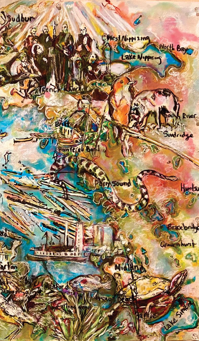
Francesca Vivenza A Painting Remembered, 2006 acrylic, fragments of maps on canvas 105 x 81 cm www.francescavivenza.com
Jordana Dym and Karl Offen, editors
Mapping Latin America: a cartographic reader Chicago: Univerity of Chicago Press, 2011
https://press.uchicago.edu/ucp/books/book/ chicago/M/bo6225459.html
books
Mirella Altic, Encounters in the New World: Jesuit Cartography of the Americas Chicago: University of Chicago Press, 2022
https://press.uchicago.edu/ucp/books/ book/chicago/E/bo95833620.html
Simonetta Moro. Mapping Paradigms in Modern and Contemporary Art: Poetic Cartography. London and New York: Routledge, 2021
https://www.routledge.com/Mapping-Paradigmsin-Modern-and-Contemporary-Art-PoeticCartography/Moro/p/book/9781032052045
Shari Fox Gearheard, Lene Kielsen Holm, Henry Huntington, Joe Mello Leavitt, Andrew R. Mahoney, Margaret Opie, editors
The Meaning of Ice: People and Sea Ice in Three Arctic Communities
International Polar Institute 2017 https://www.nhbs.com
https://www.amazon.ca/Meaning-Ice-People-ArcticCommunities/dp/0982170394
Linda Tuhiwai Smith, Decolonizing Methodologies Bloomsbury Publishing. NY 2021
https://www.bloomsbury. com/ca/decolonizingmethodologies-9781786998132/
Derek Hayes, Historical Atlas of the Arctic Seattle: University of Washington Press / Vancouver: Douglas & McIntyre. 2003
https://uwapress.uw.edu/ book/9780295983585/historical-atlas-of-thearctic/
longing
 joseph heathcott
on site review 42: atlas :: being in place 1
maps and mapping
stephanie white
'...In that Empire, the Art of Cartography attained such Perfection that the map of a single Province occupied an entire City, and the map of the Empire, an entire Province. In time, these Excessive Maps did not satisfy and the Schools of Cartographers built a Map of the Empire, that was of the Size of the Empire, and which coincided point for point with it. Less Addicted to the Study of Cartography, the Following Generations understood that the dilated Map was Useless and, not without Pitilessness, they delivered it to the Inclemencies of the Sun and the Winters. In the Deserts of the West endure broken Ruins of the Map, inhabited by Animals and Beggars; in the whole country there is no other relic of the Disciplines of Geography.
Suárez Miranda: Viajes de varones prudentes, libro cuarto, cap. XLV, Lérida, 1658'1
1 Jorge Luis Borges. 'Del rigor en la ciencia' (1946) Historia universal de la infamia, Argentina: Emecé, 1954
Diego Doval, English translation, 2017
This very short story, in its entirety, is an invented quotation on a theme covered by Lewis Carroll's 1895 Sylvie and Bruno Concluded. It is quoted in Umberto Eco's 'On the Impossibility of Drawing a Map of the Empire on a Scale of 1 to 1' in How to Travel with a Salmon and Other Essays, 1995
On Site review seems to visit maps and mapping frequently, but never as concentratedly as this issue. Maps are essential tools of exploration and conquest: if it can be measured, it can be drawn. If it can be drawn, it can be sold. If it is owned, it can be occupied. Latin Americans have had longer to ponder all this, their period of Spanish and Portuguese colonisation, said to be from 1492 with the arrival of Columbus to 1832 and the onset of the Spanish American wars, left two occupied continents, a postcolonial condition that reverberates from north to south still.
In On Site review 31, Rodrigo Barros, at the time living in Valpairiso, inverted the Mercator projection to position the South as the site of hopes and dreams, not North America, the escalator of power and interference.

The 1913 drawing superimposing European countries on the South American continent, points out just how small and overly-intense Europe was just before WWI. Land mass was not power, influence was. The Mercator projection was never a scientific drawing of the globe, it privileges the North, reducing the two continents of the South to elements smaller than Greenland. Distortions, always distortions.
Many of the essays and projects in this issue of On Site review re-think the recording of land by starting with the foot on the ground, rather than the pen on the paper. Possession becomes presence; occupation becomes belonging. This can be read as both dominion and reclamation. Like the inverted North-South drawing, it depends where one stands.

on site review 42: atlas :: being in place 2
an unused image found on a website now vanished. My notes say it was drawn in 1913.
Rodrigo Barros 2014
ON SITE r e v i e w 42: atlas :: being in place
spring 2023
On Site review is published by Field Notes Press (1986), which promotes field work in matters architectural, cultural and spatial.
contents
introduction
Joseph Heathcott
Stephanie White
Jeff Thomas
Michael Farnan
cartographies: longing maps and mapping
deep roots complex systems
Susan Shantz
Michelle Wilson
Yana Kigel
Dalia Munenzon
mapping Iroquoia mapping the Georgian Bay watershed
Confluence: the Saskatchewan River tracing carefull paths
moral implications: urbanism and wildlife drawing water from arid lands
urban markers
John Barton
Joseph Heathcott
mapped by poetry: The Troubles
cartographies: urban design guidelines 2.0
Always quite liked that for Abbé Laugier, the muse of architecture was female, and there she is, holding her divider, classical architecture in ruins at her feet. For us, it is not the primitive hut that is interesting, it is the water tower.
Lejla Odobašic Novo +Aleksandar Obradovic
Francesca Vivenza
Patrick Mahon+Thomas Mahon
Lisa Rapoport
mysteries emigration
Yvonne Singer
Salah D Hassan
cartographies: decolonising Manhattan (re)mapping: politics in urban space exchange an uncertain proposition
un-mapping: Autoroute10; Thunder Bay
the certificaat uncertain cartographies
colonial processes
David Murray
Peter Kuper
Stephanie White
maps as archives
2018 Trumpworld on some maps; 1929, slippage
calls for articles masthead
43: temporary architecture
44: architecture and play
Joseph Heathcott covers
Francesca Vivenza
Yvonne Singer
cartographies: urban powerpoint
who we are
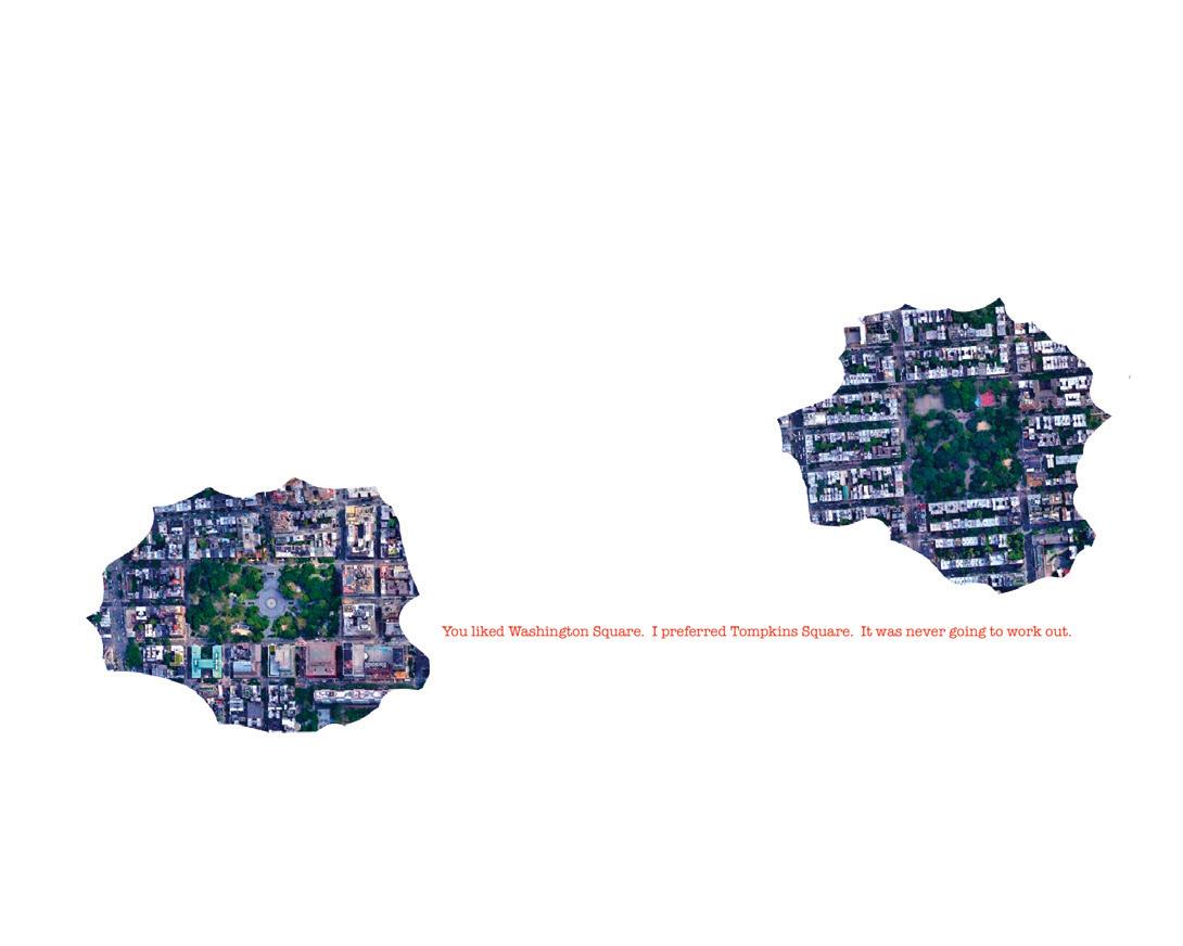
front: A Painting Remembered back: Gone Missing
on site review 42: atlas :: being in place 3
F I E L D N O T E S
1 2 4 8 10 16 20 26 30 31 32 34 38 39 40 46 48 53 60 61 62 6 3 64
´ ´
mapping Iroquoia
jeff thomas
First came the field-work, next the conversation, then seize the space.
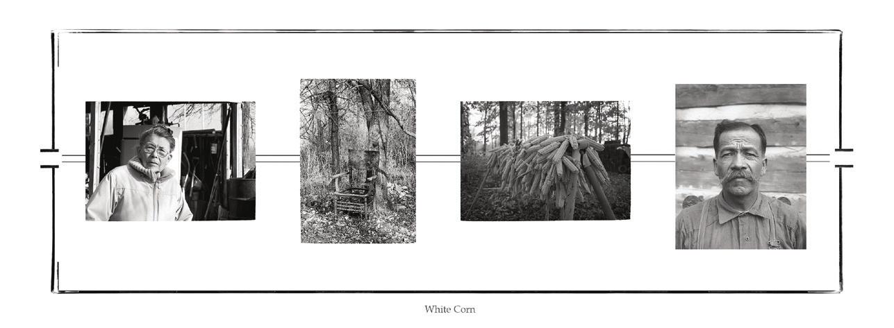
1. Wampum Belt #1 White Corn (2014/2018) pigment print on archival paper
left to right:
Jeff Thomas: Emily General (1985) Smooth Town, Six Nations Reserve. GPS: 43.01945, -80.08303

Emily General is my great-aunt and sister to my step-grandfather Bert General. Emily was instrumental in helping me define my sense of place as an urban Iroquoian. When I entered university in 1975 she gave me her copy of the handwritten story of the Peacemaker and his journey to bring peace to the warring Iroquois tribes in present-day New York State. Emily told me I could not use a photocopy machine, I had to make my own hand-written copy of the 1900 document. I did and it has been instrumental for my development as a visual artist and curator.
Jeff Thomas: Old Chair outside Emily General’s kitchen door (1985) Six Nations Reserve, Ontario. GPS: 43.01945, -80.08303
I photographed the old chair sitting outside of Emily’s kitchen door because it reminded me of the times I sat at the kitchen, listening to my elders tell stories about the old days, gossip, the price of farm animals, etc. I thought that might be my last visit to the farm and I wanted an image to remember my time with Emily.
Jeff Thomas: Drying white corn braided by Bert General (1990) Six Nations Reserve, Ontario. GPS: 43.018067 -80.08955
Francis Knowles: Chief Jacob General (1912) Six Nations of the Grand River, Canadian Museum of History. GPS: 43.018067 -80.08955
Bert and Emily had provided me with enough information to begin my journey of discovery. The Hiawatha wampum belt commemorated the Peacemaker’s journey through ancient Iroquoia and the story Emily gave me became the prototype for this journey and would lead to my self-identification as an urban Iroquois.
2. Wampum Belt #2, Cold City Frieze (1997/2016)
left to right:
pigment print on archival paper
Jeff Thomas: Chief Red Jacket monument (1997) Forest Lawn Cemetery, Buffalo, New York. GPS: 42.92315,-78.8663
Jeff Thomas: Joseph Brant monument (1997) Brantford, Ontario. GPS: 43.14077, -80.26331
Jeff Thomas: Onondaga Chief Big Sky plaque (1997) Buffalo, New York. GPS: 42.829767,-78.773417
Jeff Thomas: IROQUOIS (1998) Place d’ Armes, Montreal, Quebec. GPS: 45.50485,-73.557667
Jeff Thomas: Point of View (2015) Pittsburgh, Pennsylvania. GPS: 40.4391,-80.021367
4
Jeff Thomas, photo-based artist, independent curator, public speaker. https://jeff-thomas.ca

3. Memory Landscape (2015) pigment print on archival paper
While scouting the streets of Buffalo, New York, Toronto, Ontario, Winnipeg, Manitoba, and Ottawa, Ontario, for Indians, I have also questioned the stories the landscape has to tell me. Is there anything Indigenous about this landscape? I am speaking about the Europeanization of Turtle Island and how it inspired my quest to define my place as an urban-based Iroquois.
left to right:
Jeff Thomas: Storefront Window Display (1982) Allen Street, Buffalo, New York. GPS: 42.89918,-78.87084
Jeff Thomas: “This Is The Problem,” jacket by artist Tanya Harnett (2015) Tech Wall site, Slater & Bronson, Ottawa, Ontario. GPS: 45.41572, -75.70726
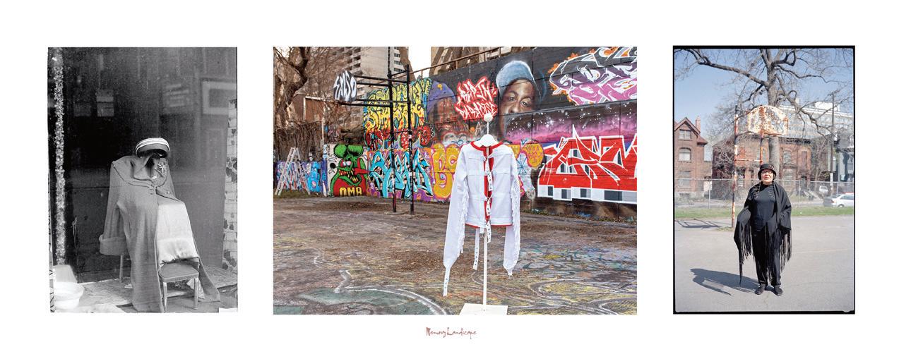
Jeff Thomas: Madeline Dion Stout, Cree (2002) Tech Wall site, Slater & Bronson, Ottawa, Ontario. GPS: 45.4153413 -75.7068984
4. Tailgate Family Portrait (2017) pigment print on archival paper
left to right:
Frank M. Pebbles (American, 1839-1928: Dr. Oronhyatekha (1841-1907), Royal Ontario Museum, ROM2008_10224_1. GPS: 43.6677 -79.39477
ORONHYATEKHA 1841-1907 (Oh-ron-ya-TEK-a) The renowned Mohawk chief, orator and physician is buried in this churchyard. Born on the Grand River Reservation, he attended the Universities of Toronto and Oxford. At the age of twenty he was selected by the Six Nations to present official greetings to the visiting Prince of Wales. In 1871 he was a member of Canada’s first Wimbledon rifle team and in 1874 became President of the Grand Council of Canadian Chiefs. Oronhyatekha was largely responsible for the successful organization of the Independent Order of Foresters.
Jeff Thomas: Clara Thomas (my grandmother), Martin Thomas (my father), Bear (my son) and nephews, Cleve, Levi and Spencer Thomas (1990) Six Nations Reserve, Ontario. GPS: 43.018067 -80.08955
on site review 42: atlas :: being in place 5
5. This Is Not Nostalgia #1 (2006/2016) pigment print on archival paper
A wistful or excessively sentimental yearning for return to or of some past period or irrecoverable condition.
left and right:
Jeff Thomas: Steve Thomas (Onondaga) (1990) Smooth Town, Six Nations Reserve, Ontario, photographed outside his home, GPS: 43.03222, -80.07591
centre:
John (Jan) Verelst: Brant 1710, courtesy Library Archives Canada/C-092419. GPS: 45.42005 -75.70789
Also known as Jan or Johannes (1648-1734), Verelst was a Dutch Golden Age painter, working in England, in the time of Queen Anne’s War.
6. This Is Not Nostalgia #2 (2006/2018) pigment print on archival paper
A wistful or excessively sentimental yearning for return to or of some past period or irrecoverable condition
left to right:
Jeff Thomas: Holland Antiques (1982) Buffalo, New York. GPS: 42.89916, -78.8773
John (Jan) Verelst: Hendrick (Theyanoguin) (1710) courtesy Library Archives Canada/C-092415. GPS: 45.42005, -75.70789
Jeff Thomas (Onondaga): self-portrait 1998, Samuel de Champlain monument, Ottawa, Ontario. GPS: 45.4294,-75.70145


on site review 42: atlas :: being in place 6
:: deep roots
7. This Is Not Nostalgia #3 (2006/2018) pigment print on archival paper
A wistful or excessively sentimental yearning for return to or of some past period or irrecoverable condition.
left to right:
Jeff Thomas: Joseph Tehwehron David (1957–2004), (1997) Mohawk, artist, and veteran of the 1990 Oka Crisis, Kanehsatà:ke, Quebec. GPS: 45.47321, -74.125
John (Jan) Verelst: John of Canajoharie (1710) Courtesy Library Archives Canada/C-092417, LAC, Ottawa, Ontario. GPS: 45.42005, -75.70789
Jeff Thomas: Bear Thomas, Cayuga (1996) Samuel de Champlain Monument, Ottawa, Ontario. GPS: 45.4294, -75.70145
I discovered background information about the three men on my son Bear’s tee-shirt. The original image is a studio portrait (possibly in Omaha, Nebraska) by William Henry Jackson; the men are identified as Pawnee Scouts. The portrait’s date is circa 1868-1871.
(First from right) ‘Man who left his enemy lying in the water’, Raruur tkahaareesaaru ‘His Chiefly Night’, or ‘Night Chief’ Ticteesaaraahki’ ‘One who strikes the chiefs first’ Tirawa t Reesa ru’ ‘Sky Chief’ Standing, Baptiste Bayhylle, Resa ru’ Siriite‚riku “The Heavens See Him as a Chief”, Pawnee/French interpreter. The seated men are identified as brothers. Smithsonian Institution, National Anthropological Archives, 1297.
8. This Is Not Nostalgia #4 (2006/2018) pigment print on archival paper
A wistful or excessively sentimental yearning for return to or of some past period or irrecoverable condition
left to right:

John (Jan) Verelst: Nicholas the Mahican (1710) courtesy Library Archives Canada/C-092421. GPS: 45.42005, -75.70789

Jeff Thomas: Justice (2006) Department of Justice building, Ottawa, Ontario. GPS: 45.42142, -75.70399
Jeff Thomas: Arnold Boyer (Mohawk), (1998) Department of Aboriginal and Northern Affairs, Gatineau, Quebec. GPS: 45.42605, -75.72173
on site review 42: atlas :: being in place 7
map depicting the settlement history and species at risk of the Georgian Bay watershed
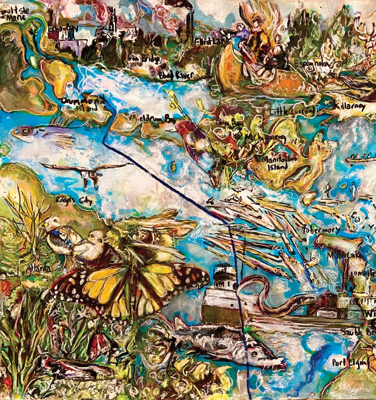 michael fa rnan
on site review 42: atlas :: being in place 8
:: deep roots
Michael Farnan is a multidisciplinary artist and educator, living and working in Victoria Harbour, Ontario. His current research focusses on mapping the settlement history and biosphere of his home community on Georgian Bay. www.michaelfarnan.ca
on site review 42: atlas :: being in place 9
Michael Farnan. Georgian Bay Watershed and Species at Risk. 2022 Ink, chalk and charcoal on paper. 24 x 36"
Confluence
susan shantz
My recent art exhibition, Confluence, uses contemporary cartographic road maps as source material to search for an alternative, watershed map of the Saskatchewan River from source to delta and ocean across three prairie provinces.1 Using drawing, embroidery and large-scale cutwork tarps, I explored my river connection to the place where I live in Saskatoon which is divided and defined by water on the prairie. By tracing the currents of streams and rivers with ink, thread, paint and cut-outs, I followed meandering water lines that interrupt the boundaries of the regulated prairie grid, connecting my point on the river to humans and more-than-humans2 upstream and down.
What if my territory of belonging were defined by the course of water rather than land? Might I discover the point of view of a river with my pencil/pen/needle/knife? Draw, stitch and cut my way through the overlaid network of occupation to the find the undercurrents of water in the watershed territory I inhabit? Confluence contrasts the fragmentation and gridding of the prairie through surveying and mapping with the less visible path of water.
1 The Saskatchewan River delta, the largest inland delta in North America, spans the Saskatchewan-Manitoba border near Cumberland House, Saskatchewan connecting Treaty 5, 6 and 10 territories with many Cree and Metis inhabitants. It is considered the terminus of the Saskatchewan River watershed after which its waters become 15.4% of the water in the Nelson River which flows into Hudson's Bay.
https://www.hydro.mb.ca/assets/img/figurebox/dry-conditions-arent-only-factor-in-mh-water-supply-2.png

Accessed 21 Nov. 2022.
2 'more-than-human' – a term used in some academic disciplines to question the binary of human/nonhuman and culture/nature.
on site review 42: atlas :: being in place 10
figure 1: Streams, rivers, lakes and delta marshland of the Saskatchewan watershed traced in blue ink from a cartographic source map. (figure 5) Water Basin II, coloured pen on paper; 45.7 x 31.8 x 3.2 cm (each panel), 2019
:: complex systems
Gabriela Garcia-Luna
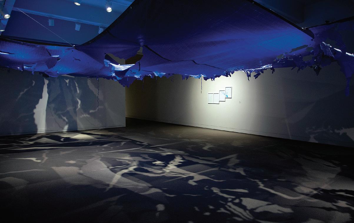
I (Saskatchewan River), installation; 4 tarps, 359 x 1280 x 853 cm, 2018-2019

A watershed dream is shared by contemporary bioregionalists as well as the visionary nineteenth century head of the U.S. Geological Survey, John Wesley Powell, who, in 1890 proposed dividing the arid American west along twenty-three watershed boundaries.3 Now, in a time of climate crisis, this vision is needed to remind us of what has been lost even if it seems only a dream from an unrealized past. What might it mean to live with 'watershed mind'?4 To feel the connection between water in and outside our bodies, upstream and downstream from our point on a map? Might “watershed” itself be too static a term for something so fluid -- given water is an element that erodes edges and consists of multiple “nested and overlapping scales ranging from the interiority of individual bodies to the planetary hydrological cycle.”?5
3 Ross, John F. 'The Visionary John Wesley Powell Had a Plan for Developing the West, But Nobody Listened'. July 3, 2018. https://www.smithsonianmag.com/smithsonian-institution/visionary-johnwesley-powell-had-plan-developing-west-nobody-listened-180969182/ Accessed 8 Nov. 2022.
4 Peter Warshall used this term to describe the shift in thinking needed to better align ourselves with water. Warshall, Peter. 'Watershed Governance'. Writing on Water, edited by Rothenberg and Ulvaeus, MIT Press, 2001. p 47
5 Biro, Andrew. 'River-Adaptiveness in a Globalized World'. Thinking with Water, edited by Chen, MacLeod, and Neimanis, McGill-Queen’s UP, 2013. p 175
on site review 42: atlas :: being in place 11
figure 2: Traced ink drawings from figure 3, upscaled to cover four tarps. The Saskatchewan Watershed --- streams, rivers, lakes and delta marshland – is cut into the tarps to create connected and gaping overhead basins and paths that cast shadow maps on the floor and walls. Water Basin
Gabriela Garcia-Luna
local topographic maps.

Confluence II (Bow/Oldman/Red Deer/Saskatchewan Rivers), bookwork; mixed media on pellon, 312.4 x 426.8 x 782.3 cm, 2020-2021


Confluence I (Bow/Oldman/Red Deer/Saskatchewan Rivers) bookwork; paper, thread, 188.0 x 24.1 x 7.6 cm, 2017

on site review 42: atlas :: being in place 12
figure 3: River canoe route through the badlands traced from pages in a guide book then machine-sewn on paper and accordion-bound into an undulating, overlapping book that opens and spreads, wave-like, across a horizontal plain.
figure 4: The South Saskatchewan River carves its way through badlands seeking the lowest point of gravity; these water currents are represented by long strands of embroidery floss sewn in running stitches across eight panels enlarged from the pages of a book of
:: complex systems
all images this page: Gabriela Garcia-Luna
figure
River Wear (for managers), found objects, embroidery, 137.2 x 35.6 x 94.0 cm (each), 2018-2020


left: detail of River Wear (for managers: glacial source)
River Wear (for managers) with video projection of the artist’s hand embroidering the path of water across the prairie overlaid with the footage of the river’s changing water surface and sounds of geese in migration.


River Wear: Current, video (looped), 2:54 min, 2020 https://vimeo.com/768284162

on site review 42: atlas :: being in place 13
5: Embroidered shirts for water managers with three key areas of the Saskatchewan watershed represented -- glacial streams, prairie meander and delta dispersion – all of which need care and attention in a changing climate.
all images this page: Gabriela Garcia-Luna
A number of pieces in Confluence began as small-scale tracings from conventional maps, as I sought the path of water, using pen, paint and thread. Scaled up, these became large installations: the blue ballpoint ink lines of water lines hidden amidst the roads and towns of three prairie highway maps were increased, inches to feet, and cut into azure-blue tarps hung overhead to cast shadow-maps below (figures 2 and 2a); the accordion-fold bookwork of the river meandering through the soft topography of badlands expanded to eight stitched fabric panels cascading down the wall of the gallery and across the floor (figures 3 and 4). In another series, I embroidered the path of water in three key watershed zones onto the back of white-collar shirts for water managers. If we wore the river, like a ritual garment connected physically and imaginatively to our bodies (figure 5), might we make different decisions about the upstream and downstream waters that connect us -- humans and more-than-human beings – in our watersheds?
After completing and exhibiting the Confluence installation, I returned to my map-source and, with white paint and a fine-pointed brush, covered over the grid-lines and dots of roads and towns to better see the connecting paths of rivers as well as the loose outline of the watershed that holds them. This hydrocommons, beneath the ghostmarks of civilisation (figure 6), is a threshold edge, opening to the white ground of the map itself and revealing a permeable space. Like the water’s shoreline on a river or lake, it is a more complex zone of transition than John Wesley Powell might have imagined with his demarcated governance boundaries.

on site review 42: atlas :: being in place 14
figure 6: Redacted map of three prairie provinces with the connected dots and lines of roads and towns painted white to reveal the Saskatchewan River watershed from the Rocky Mountains to the Saskatchewan River Delta. Finding Watershed (redacted prairie maps), white paint on found paper maps, 129.0 x 89.0 cm (detail), 2022
:: complex systems
Susan Shantz
While mapping conventions were my starting point for the works in Confluence, my materials and methods upended those conventions and dissolved the smooth surface of the map into complex fragments. Those who entered the space of Confluence heard the babble of water6 as my multi-scaled, reconfigured maps expanded the parameters of mapping. From video and audio to embroidered shirts, to tarps and books, Confluence exhibits multi-sensory modes of knowing that come closer to the complexity of land over and under water; of water shifting land and land directing water. p
6 Cecelia Chen uses this term to describe the excess metaphorical 'noise' of water that may go beyond conventions of both mapping and knowing leading to experimental and diverse methods of representation. 'Mapping Waters: Thinking with Watery Places'. Thinking with Water, edited by Chen, MacLeod, and Neimanis, McGill-Queen’s UP, 2013. pp 278 – 298
Those who entered the space of Confluence literally heard the sound of water from three video/audio projections of freezing/melting ice/water from streams and rivers in the watershed.
Confluence was recently exhibited at the Moose Jaw Museum and Art Gallery, February 4-May 1, 2022.
Susan Shantz teaches studio art in the Department of Art and Art History at the University of Saskatchewan. Her multi-media artwork, Confluence, considers the Saskatchewan watershed and was informed by collaborating with environmental scientists.
https://www.susanshantz.com/confluence
on site review 42: atlas :: being in place 15
figure 2a: Traced ink drawings based on figure 2, enlarged to fit on four tarps. Streams, rivers, lakes and delta marshland are cut into the tarps to create connected and gaping overhead basins and paths that cast shadow maps on the floor and walls. Water Basin I (Saskatchewan River), installation; 4 tarps, 359 x 1280 x 853 cm, 2018-2019
Gabriela Garcia-Luna
tracing carefull paths

on site review 42: atlas :: being in place 16
michelle wilson
michelle wilson
:: complex systems
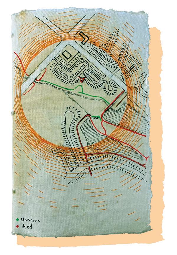
The Coves Collective. Tracing Csrefull Paths (work in progress), 2022-2023. 80cm x 70cm, linen and cotton fabric, merino wool thread, black raspberry, goldenrod and black walnut dyes, time and community.
My storytelling meanders, retraces itself, stays in place and excavates, changing slightly with every narration. These stories trace the contours of movement, for example, migration routes or rivers. And so, I use maps to guide their telling; maps that, like ‘land,’ are formed through relations. They are mnemonic devices that direct my wandering mind.
On this map, we, the Coves Collective, illustrate the land we traced with our bodies during walks and workshops and recorded with GPS apps (see the white-on-white stitches). We create images with threads stained and dyed with plants from this place. Soils with long memories nourished these plant beings. They remember the relationships that played out across their surfaces, the toxins that leached down or were born through groundwater, and the bullets and chemical tanks embedded in their depths.
This island of land, nestled in the crook of a horseshoe of muddy ponds, was formed millennia ago by a meander off the river known to its Anishinaabe stewards as the Deshkan Ziibi or Antler River.1 Settlers had yet to sever this meander from the Deshkan Ziibi when the Deshkan Ziibiing Anishinaabeg signed McKee Treaty No. 2 and London Township Treaty No. 6.2 As deceitful as those treaties were, one thing is clear: the Deshkan Ziibiing Anishinaabeg never ceded title to the bed of the Deshkan Ziibi.3


Following the ponds’ banks today, I have found that only one trickling finger stretches toward the Deshkan Ziibi. This is because the river inflow was blocked over a century ago by railway embankments and later, in the 1950s, by a garbage dump. Still, I understand this place, known as the Coves, as part of the watershed that the Deshkan Ziibiing Anishinaabeg nation never ceded. But what does ownership mean when we understand that this area also falls under the inherent Indigenous rights of the Minisink Lunaape (Munsee-Delaware Nation) and the Onyota’a:ka (Oneida Nation of the Thames)? The waters that wore away the banks that define and protect this place also mark it as a place where I can feel what should be palpable throughout this town, province, and country; I am on Stolen Indigenous Land.
So, who does this land belong to?

1 Later the French called it La Tranchée. Most recently, LieutenantGovernor John Graves Simcoe called it the Thames River.
2 The Deshkan Ziibiing Anishinaabeg are commonly referred to today as the Chippewa of the Thames First Nation.
3 This is a brief and simplified interpretation of the treaty relationships in London, Ontario. For a thorough and more nuanced understanding I urge you to read "London (Ontario) Area Treaties: An Introductory Guide" (2018) by Stephen D'Arcy. It is available at: http://works.bepress.com/sdarcy/19/
on site review 42: atlas :: being in place 17
This answer, again, returns us to the river. In 1937 the Deshkan Zibii crested its banks and swamped much of the city of London, Ontario. In response, the city instituted flood control measures that arrested the seasonal submerging of the lowlands held within the oxbow. Thus, on the eve of the Second World War, the Canadian government offered up this land, which they had used for nearly sixty years as a rifle range and training ground for agriculture.
Simultaneously, the advancing tide of German expansion drove the Wolf family from what was then Czechoslovakia. In 1939 Thomas Wolf purchased nearly all the land we have mapped in this piece. He planted a fruit orchard, built a house, and quietly continued his family trade in the basement, mixing paint.


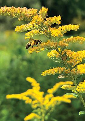
Within a decade, Thomas Wolf and his family established the Almatex Paint company. It expanded quickly, and before anyone could raise alarms about the environmental impact, it became a significant employer in the city. The factory closed in 2001. Its warehouses, laboratory, and factory are gone. However, the chain link fences topped with barbed wire, cement pads, and blocks of concrete threaded with rebar remain, marking where the toxic chemicals were once mixed. This summer, I led walks through a hole in the fence to this site. We poured water gathered from the ponds onto a living artwork: a ring of goldenrod planted by the Coves Collective into a trench we cut into the cement with a circular saw. This goldenrod removes lead in the soil, one of the many invisible presences Almatex left behind. In the center of the ring, we marked our presence by stacking rocks and chunks of concrete to form a cairn. In August, the former factory site is similarly ringed with four-foot-high goldenrod, nourishing swarms of bees, vibrantly declaring that these plant beings are already working to heal this place. The Coves Collective's work humbly draws attention to what these plant beings have already begun.
I told those who accompanied me on my walks about Mrs. Ayshi Hassan, who wrote to the city in 1971 and informed them that all the birds had left the area, driven away by the stench of noxious fumes. I told them about the "paint pit" that children set on fire in 1966, creating a column of smoke that rose hundreds of feet above the land we stood on. I told them about the two towering evergreens that were felled in 1981 when a labour strike turned violent; the Almatex management replaced the trees with a giant pole topped with a CCTV camera. One day as I was telling these stories, two deer raced around the interior perimeter of the fence, circling us before escaping through a gap known only to them. One of the youths with me that day asked, “what is the opposite of traumatized?”

Valspar, a subsidiary of Sherwin Williams, who bought out Almatex, still owns this land. Their contractors only visit the site to test the groundwater through blue test wells that dot the land.
But does the land belong to them?

on site review 42: atlas :: being in place 18
:: complex systems
michelle wilson
We walked the trails made by humans and animals and picked up the small apples that still grow yearly. I heard that decades ago, the caretaker shot salt pellets at the children sneaking into the orchard to eat the fruit. There we found half a ginger cat, consumed by the resident coyotes. A child left behind tobacco and the whispered words, 'rest in peace'.
As recently as the 1920s and 30s, the ponds that circle this land still flowed with water from the Deshkan Ziibi. They were so clear and clean that settlers set up ice-harvesting businesses on their banks. Now the only water that flows into them is runoff from streets and neighbourhoods. This has kicked the natural sedimentation process into overdrive. The water has become nearly opaque in places. In the spring of 1970, almost all the fish in the East Pond died. Today there are thriving populations of turtles and Common Carp. The carp, a non-native giant in these small waterways, stir up the silt, keeping sunlight from penetrating these waters and keeping aquatic vegetation from taking root. These carp are too big to be prey for the herons and egrets who have returned to nest on these banks. So, as the Coves Collective, we have tried to establish better relations with this place by harvesting carp. We honour their lives by eating their flesh (when it is safe) and tanning their hides (which will eventually be incorporated into this map).
We do this work because we attend to this place; as we walk here, harvest clay and plants here, and attempt to enter into reciprocal relations here. Not because this place belongs to us but rather because we, the Indigenous and non-Indigenous members of the Coves Collective, are in the process of belonging to this place. p

The Coves Collective is an ad-hoc group of artists, educators, and activists that have come together to attend to our responsibilities and relationships with the Coves, an environmentally significant area recovering from years of misuse. These actions include Tracing CareFull Paths, a communityproduced textile map facilitated by Michelle Wilson and Reilly Knowles, on the land teachings, including traditional medicine gathering and medicine pouch making led by cultural-justice coordinator Candace Dube, and clay harvesting and vessel making guided by Indigenous ceramicist Shawna Redskye.
Michelle Wilson is an artist and mother currently residing as an uninvited guest on Treaty Six territory in London, Ontario. She earned a PhD in Art and Visual Culture from the University of Western Ontario and is currently a post-doctoral scholar with the Conservation Through Reconciliation Partnership at the University of Guelph. www.michelle-wilson.ca
on site review 42: atlas :: being in place 19
michelle wilson
the moral implications of urban design in proximity to wildlife
 yana kigel
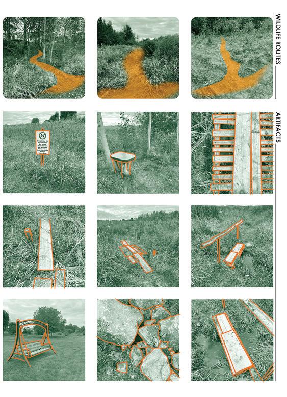
A small pond, a distributary of the Carp River and located within the developing Ottawa suburb of Stittsville sits in what was once an undeveloped buffer zone, separating an established neighbourhood from agricultural land. Recently, the urban sprawl encircling this piece of land has encroached on the undergrowth with the freshly laid-out trail of Abbottsville, a paved addition that overshadows the many organic paths large and small, just as the unnamed pond is dwarfed by the well-known Carp River.
I live in this relatively new neighbourhood. With windows overlooking these pathways, I have had a front-row seat to the intrusive construction that has appeared over the last three years. Suburbanites often rationalise their relocation by denouncing the lack of greenery in the city centre; hence, moving from a busy metropolis to a quiet suburb, I also envisioned the promised closeness to nature. However, upon moving, I began to see that the green suburbs had failed to create a place of harmony with nature. Instead, the streets, victims of land manipulation, were deceptively moulded to appear ‘green’. Traditional suburban landscape works to sterilise natural landscapes rather than promote an ecosystem that connects humans and wildlife. The remaining patches of forest lands are isolated in the existing urban fabric. Wilderness is expelled from our daily routine, visited only through planned excursions.
on site review 42: atlas :: being in place 20
:: complex systems
Yana Kigel
what defines a path?
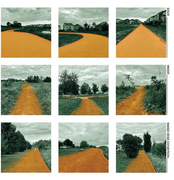
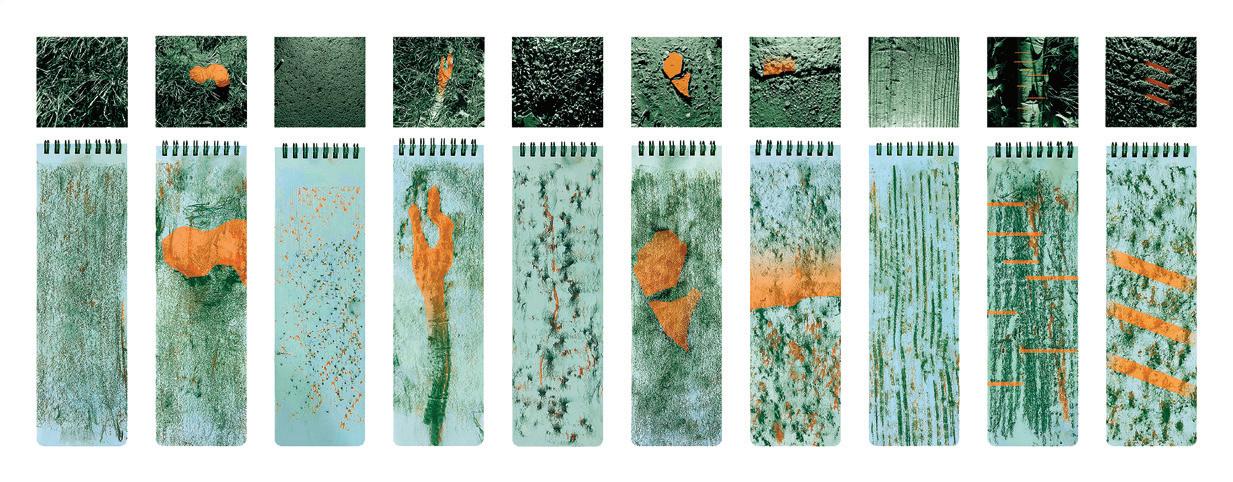
Environment and intent influence how we subconsciously pick which trail is worth travelling along. In small-scale urban parks, designers typically attempt to navigate the traffic by accentuating an abrupt change in materiality along the boundaries - pavement against earth, manicured turf against overgrown plants, the purpose being to make it accessible both visually and physically. As a result, most people stay on the pavement, avoiding extensions that appear uncharted or unstable. These more ambiguous, organic trails are hence less inviting. They have a smaller footprint, a less visible border, and subtle material transition. Only in a less controlled environment, such as a forest, could such pathways be expected to deviate from the established routes. We recognise that we may encounter the unknown - a wild animal, an unexpected puddle, or a dead end. Another alternative, increasingly challenging to locate, is a route that hugs an edge. An existing border, such as of backyards, agricultural fields, or rivers, define these types of boundaries. Unlike spread asphalt or prints left by previous visitors, it is far more challenging to determine if an edge may be intended for travel or if it is part of an off-limits, private property.
In our still semi-underdeveloped site, the Abbotsville trail, the only paved path constructed by the urban planners, is popular among the residents of the streets whose properties border it. The rest of the informal paths are on terrain of natural rocky surfaces, flooding gaps and artificial scrap bridges, all of which are difficult to use. The few paths made by animals are too narrow for human use and typically disappear into dense vegetation. They too are difficult to follow and are rarely explored. The only traces of human activity are artefacts left behind on these overlooked paths, such as a brought-in swing, a worn-out chair, or gardening equipment. With such secrecy and enigma, these routes are held sacred by their select users. Their unpredictability, emptiness and seasonal changes make them feel as though they are constantly ‘discovered’.
This series of photographs was the initial step in documenting the site spatially; it intended to exhibit the trails in a way that offered an environmental backdrop while marking the segment's start and finish through an orange overlay.
on site review 42: atlas :: being in place 21
Yana Kigel
simplify: strip the context
Unsurprisingly, the previous ways of analysis were carried out from a human perspective. The fundamental problem of dissecting a path through photographs of edge states was its overflowing context. Though natural tracks were walked on less frequently than paved ones, traffic's visual contours made them easy to detect. Crucially, breaking free from an analytic human perspective, new paths may be found, or in this case, missed. We built models to reduce and abstract the volume of visual data found on any path. With decreased information, pathways can only be speculated. Paths that are visually obvious become illegible. It was now easy to imagine how an animal, unaware of human courses, might see the area. For aquatic species, it was the waterways that were the primary means of transportation. Land animals used a variety of terrain for travelling, seeing only the water and structures as constraints. Birds used landmarks such as the tops of trees and higher edges of buildings for their orientation. It is fascinating, especially in contrast to humans, how little importance fauna places on sticking to the beaten path.
The fundamental problem with photographic analysis, conducted from a human standpoint, as is customary, is a site's overflowing context.
Breaking this custom by separating oneself was important to gain a new perspective. As a means of documentation, model building decreased the amount of visual data and broadened the perception of the research. The focus has shifted from an individual to a more extensive range of site users. Five paper models each portray a separate area of the routes. Now, with reduced information, the pathways could only be guessed at. Paths that once had clear indicators are now completely incomprehensible.
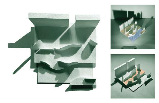
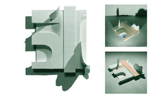
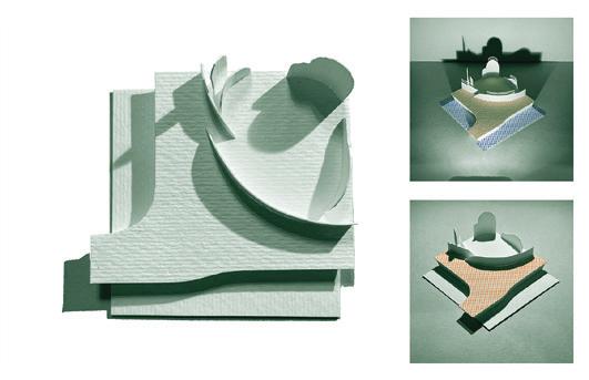
Context is absent from the initial models. The addition of color accentuates the ground, water, and treetops, all used by varied forms of fauna, disregarding any solid route. The previously documented but now concealed manmade route is finally exposed.
on site review 42: atlas :: being in place 22
:: complex systems
Yana Kigel
accentuate: select the context
This fascination led me to explore a different technique that did the opposite of selective omission, which removed textural context and what geometry defines a path. I made a more tactile record, focusing on the surfaces of the trails, and found that one may overcome the need for visual cues and instead follow the path from touch alone – scenery or destination hardly matters compared to the sensation of walking and the feeling of the ground beneath. Organic routes awaken the sense of touch; we become aware of where we step, how we step, and what we step over. We begin to feel more present. The constant variations allow us to appreciate the ground truthfully. A lack of textural variation makes the walking experience less personal and intimate:
Hard, then softer. Wet. A crawling bug? Squished again. Poking root! Paw prints.
The pavement..
It is just hard, then still hard, and hard once again.
It's a shame that natural paths aren't frequently considered throughout the planning phase of parks. To find these, we must go out of our way and visit still-untouched sites or organise a trip to the woods, where the requirement to plan an event takes away any genuine spontaneity. Synthetic walkways are designed to be trusted and so are unnoticed in the process of walking. Our sense of touch is diminished, the environment is sterile, we start to dissociate from nature as the experience becomes artificial. The bleakness of so many modern urban parks suppresses so many of the sensations that make us human. This pushes a human disconnect from wildlife, expelling them from their natural habitats and keeping them from thriving in newly designed ones.
The frottage method captures the ground's texture, first with stiff graphite, followed by softer, warmer-toned chalk, picking up the most prominent elevations. Following the flat representation on paper, clay impressions were taken to preserve the threedimensionality of the different surfaces.
This 'roughness' analysis sheds light on potential preferences among path visitors. Solid and uniform surfaces attracted older residents and children, as well as turtles and larger fowl. Young adults, dog walkers, larger mammals, and rodents, however, preferred the more irregular surfaces.
on site review 42: atlas :: being in place 23
Similarly to selective omission, an inverted method was used to study the segments.
Yana Kigel
determine the focus
Where does this shift in focus from over-designed human ways to ones of wildlife and their organic route-making practices take us? On my study site, I want to preserve a fragment of animal migration corridors before the expansion of human settlement fully eradicates it. My site visits eventually became routine without thought or preparation, promoting detours and a desire to explore. I no longer made it a mission to travel from point A to B, but rather, I began following the sounds of birds, the scents of plants and the movements of weasels.
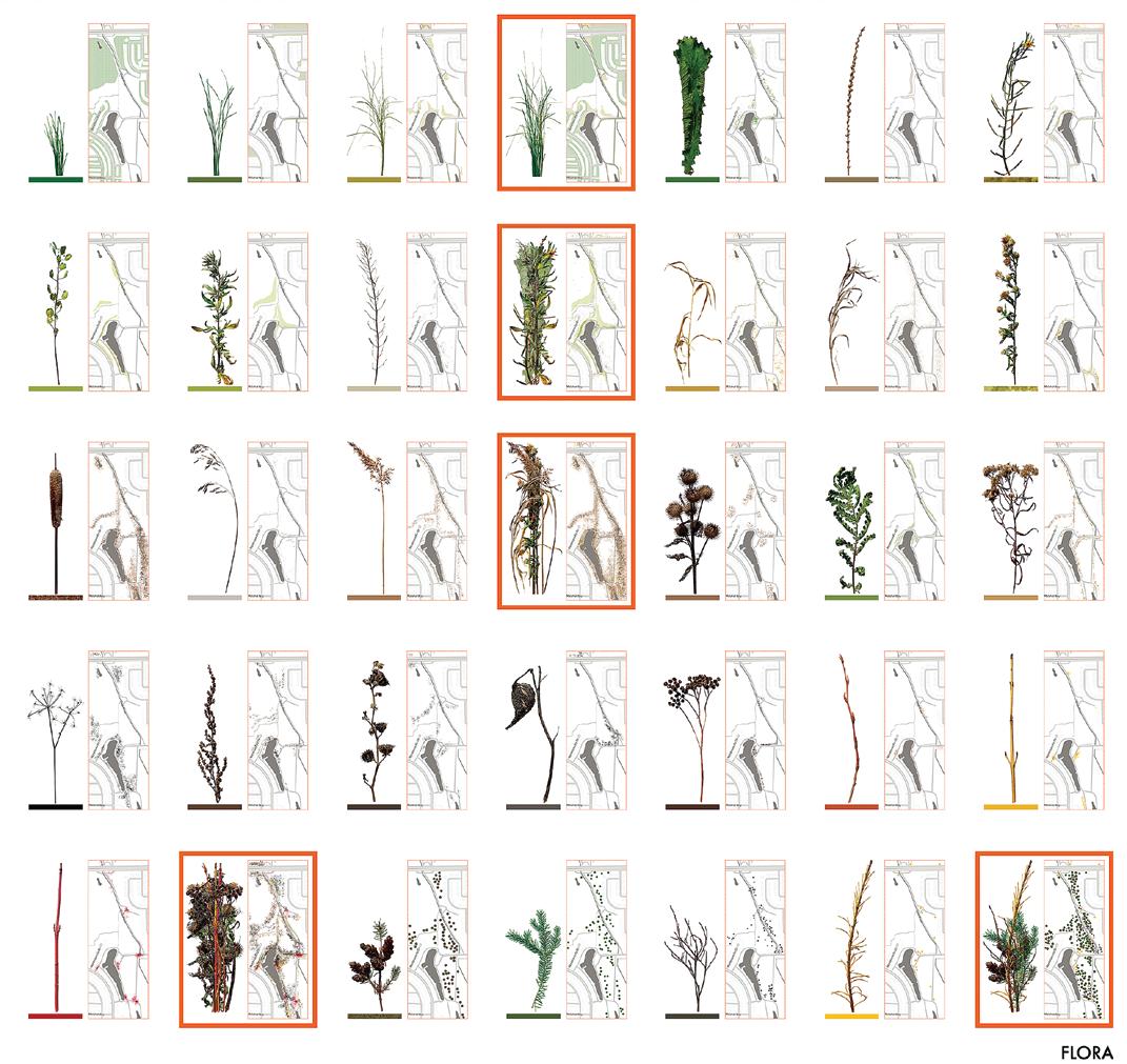
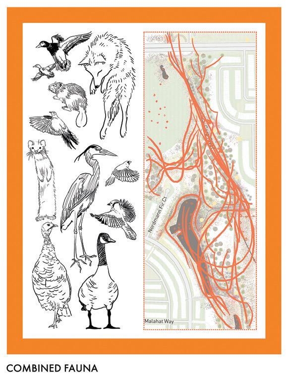
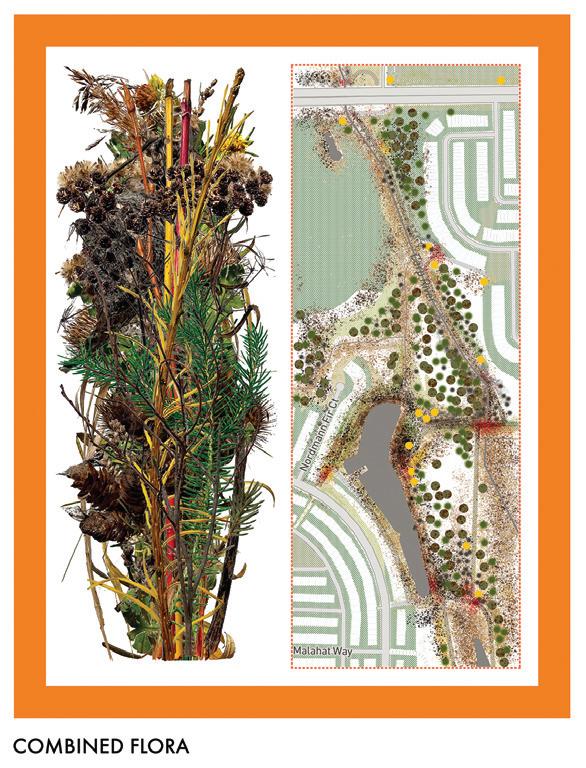
Here the focus shifts from human observation to wildlife and its organic route-making practices. The site's flora: short grasses, weeds, shrubbery, and trees. The fauna: several animals on site. Maps chart their rough trajectories throughout a three-year period.
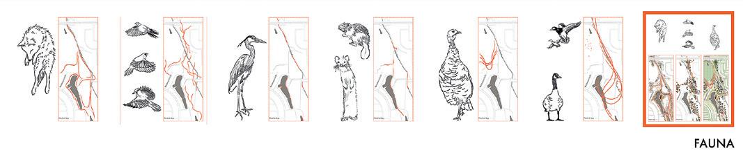
Animal migration routes and their overlaps were revealed. Rodents like crevices and dense shrubbery, while coyotes follow cleared-out ways. Turkeys prefer the transition zone between open grasslands and densely forested areas, and songbirds mostly fly between treetops. Herons, beavers, weasels and ducks share the overgrown streams. Geese congregate in open areas near bodies of water and pastures. This more profound comprehension of animal preferences was possible only once I eliminated my preconceptions about what constituted a route. Without this, I would have stayed oblivious to their habits. So how can we, architects, urban planners and designers, continue to claim that we care to build with nature in mind when we actively work on segregating it through construction, sterilisation, and demolition?
on site review 42: atlas :: being in place 24
:: complex systems
Yana Kigel
the Abbottsville Trail and its sacred extensions
Site analysis is a crucial first step in architectural and urban planning before any design process begins. A study may be carried out in various ways, typically with a particular objective in mind; it is rare for the aim to be uncertain or absent. This research began with neither a framework nor an end in sight but merely with a personal interest in trail usage and prior familiarity with the region's volatile wildlife population.
It proceeded with a lack of specificity, exploring new approaches to understanding and interpreting a site. It established relationships between path-making, humans, fauna, flora and the ground itself. Although the Abbottsville Trail analysis did not lead to a design proposal, the knowledge acquired from this work was reapplied to my thesis, A Golden Green Belt: Integrating Nature in Ottawa's Next Suburbs
Experimental and intensive site analysis techniques enabled the thesis to strive for a more dynamic and environmentally friendly neighbourhood layout, encouraging future projects to invest more thoroughly in the design research stage. p
Yana Kigel has completed her undergraduate and graduate degrees in the architecture program at Carleton University and is presently working at Carleton Immersive Media Studio. The topic of this text expanded into her thesis.
https://curve.carleton.ca/f0f21af2-a73f-4bb4-bec9-ee5260822733
on site review 42: atlas :: being in place 25
Yana Kigel
drawing water from Aridlands
dalia munenzon
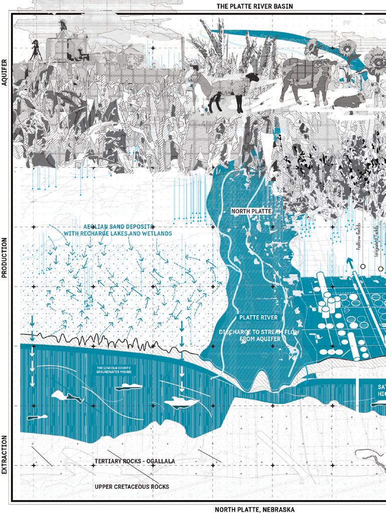
On America's Great Plains, water in all states of wetness shapes both landscape and subterranean strata, bonding and holding down soil and flora. West of the 100th meridian, surface water is limited and annual precipitation on the plains is below 20 inches/ 50cm a year. As groundwater from aquifers is the primary source of life for any territory at the centre of agricultural production, the depletion of the Ogallala – the High Plains Aquifer – through hotter, drier and more unpredictable weather, jeopardises local ecosystems and communities. This invisible relationship between extraction, production, and the flow of natural resources is key to understanding future risks and opportunities for adaptation. Watershed-based readings of the landscape make these processes visible.
t he High Plains Aquifer
Water from the saturated limestone sponge, the geological terminology for the aquifer, contributes to the annual production of $35 billion worth of crops, a quarter of national crop production. This remnant of an ancient ocean stretches from Texas to South Dakota and provides water to 112 million acres/4.6 million ha of farmland and grazing. Despite being deep underground, stationary groundwater and moving surface water are fundamentally intertwined as the aquifer discharges into streams and rivers. A decline in the aquifer's water level directly affects local streams that are drying at the rate of 6 miles per year.1
Pumping for agriculture, industry, and residential use from the High Plains Aquifer started in the early 1900s, accelerating in the mid-century with technological developments in gas pumps. Since the 1950s, high-volume pumping has led to a water level drop of 325 billion gallons every year, between 9% and 30% of its volume, and is projected to lose 40% by 2070. With 90% of the water drawn being used for agriculture, the sustainability of long-term use is rooted in regional water management and use policies.
re ading the landscape
In 1878, the geologist John Wesley Powell released his study on the farming and settlement capacity of territories west of the 100th meridian. In 'On the Arid Lands of the Western United States'2 he stated that there is insufficient surface water or precipitation to sustain European farming practices and that any farming will require irrigation. He proposed managing and dividing the territory based on watersheds, creating administrative structures based on the natural formation of the landscape to allow rational water distribution. His proposal was rejected. However, the projected climate changes and the rapid depletion of the High Plains Aquifer points to a concept worth revisiting.

cross-boundary recharging
The composition of sand and gravel in the High Plains Aquifer makes recharging complex and lengthy. Climate variability across the Great Plains, land cover changes and rate of water seepage result in recharge rates ranging from less than 1mm/year in parts of Texas to more than 150mm/year in the Nebraska Sandhills. This implies that the aquifer will take 6,000 years to recharge fully.
1 Ralls, Eric. 'The High Plains Aquifer Is in Danger of Drying Up' Earth.com, 15 Nov. 2017, https://www.earth.com/news/high-plains-aquifer-drying/.
2 Powell John Wesley et al. Report on the Lands of the Arid Region of the United States : With a More Detailed Account of the Lands of Utah. Belknap Press of Harvard University Press 1962.
on site review 42: atlas :: being in place 26
:: complex systems
Each of the states across the HPA has different regulations for groundwater and surface water use. Some states view surface water as a public resource and groundwater as private property. There is an understanding between the neighboring state of shared ownership and responsibility over surface water resources. However, when one state is geographically located at the top of a watershed, its water use might dramatically reduce the access for the state at the lower basin of that river. Therefore, agreements are used to ensure the fair use of water between these states.

In an ironic twist, agreements are met by seeping HPA groundwater from one state and pumping it into river tributaries in another state. For example, Nebraska's
Cooperative Republican Platte Enhancement project involves purchasing retired farms and installing highcapacity wells to pump water from the HPA and pipe it to Medicine Creek.3 Despite regulations and policies that usually make a distinction between surface water and groundwater, this process causes an absurd situation in which a manufactured process increases the flow between the two – therefore introducing groundwater back into the 'regulatory' commons.

on site review 42: atlas :: being in place 27
3 N-CORPE. (n.d.). N-CORPE, the Nebraska Cooperative Republican Platte Enhancement project. N-CORPE. Retrieved December 19, 2022, from https://www.ncorpe.org/
Dalia Munenzon
the commons as a commodity
Reducing the amount of water extracted for irrigation is connected to state and federal law, water rights, tax incentives, insurance mechanisms, and crop needs. Each state among the eight sharing the aquifer has rules and frameworks that allow (and unintentionally encourage) depletion. Water rights across each state both enable and limit use and distribution in various ways according to the flexibly defined 'beneficial use'.
In Nebraska, surface and groundwater are subject to public management and oversight. Groundwater is subjected to Correlative Water Rights, and Water First-inTime Rule limits surface water. An annual water assessment study evaluates comprehensive water conditions - ground and surface - per watershed. Kansas holds the jurisdiction of all water rights in its territory and allocates permits for use. In Oklahoma, groundwater use permits are issued per the land acreage held.
Texas differentiates between ground and surface water through rights given to landowners. Surface water is owned by the state and allocated by permits. According to the Rule of Capture, groundwater belongs entirely to the landowner overlying it - sometimes called the 'law of the biggest pump'– in a shared aquifer, over-pumping one property can impact neighbouring wells.
crops and stewardship
The Great Plains region has a strong connection to water and oil extraction. Post-WW2 industrialisation led to the development of technologies for these extractions, illustrated in the maps. They show the site, county, and extraction section on a large scale. The reliance on oil prices in agricultural production requires farmers to develop strategies for reducing their water demand when oil prices rise.

The crop type grown and how it is cultivated affects water demand. In the past, rising oil prices motivated farmers to explore new crops and diversify by combining perennial grasses to steer away from monocultures. Indigenous landscape management strategies and the integration of crops and livestock are rooted in the relationship between flora species and their support systems. Now, with the aquifer depletion, these practices should be re-examined. The main crops grown in each state are different in their water demand. From the 'thirsty' corn in Nebraska, consuming 22 to 30 inches of water per acre, cotton in Texas requiring 12 to 24 inches of water per acre, to grains such as sorghum, which only requires 15.5 inches of water per acre. As aquifer levels drop and droughts become more frequent, farmers adapt by reducing consumption and switching to drought-tolerant crops. Kansas farmers have reduced water consumption by a quarter without sacrificing profits, while West Texans are
transitioning from water-intensive to drought-tolerant crops and grazing. Ultimately, decisions regarding planting and management are based on acreage and well capacity. Thus, removing the misguided notion of water abundance strengthens our understanding of ecological systems and relationships. And a closer relationship between the farmer, the soil, and the occupiers of his property.
on site review 42: atlas :: being in place 28
:: complex systems
Har vesting rainfall is becoming increasingly necessary in areas where recharge is nearly impossible and the water table is shallow. To effectively manage this deluge, it is essential to consider topography, large-scale watershed systems, and minor historical traces of water flow, such as draws. This vision requires collaborative management of resources between neighbours at a scale beyond just a single property. Reading the High Plains Aquifer environment through a watershed-geological lens is only complete by considering the final component of precipitation. p

Dalia Munenzon is an assistant professor of urban design in sustainable communities and infrastructure at the University of Houston Gerald D Hines College of Architecture and Design. www.daliamunenzon.com

on site review 42: atlas :: being in place 29
mapped by poetry
THE TROUBLES JOHN BARTON
until what centres no longer holds us, we compose pictures along the Falls Road, our car stopped shoppers window-gazing and unaware of the feints of shadow and light we insinuate among pyramids of fruit or trail across headlines in the newsstand tabloids as we jump quickly in and out, frame time with our viewfinders, the countless murals we snap drafted by sympathizers on the long overexposed exterior walls of the steep-roofed, red-brick, soot tarred houses, grocers, haberdashers, and hardware shops, murals about strikers who, two decades ago in Armagh, starved to death by choice, the English prison not far from the seat of my mother’s family who left the North years before the Famine, later Loyalists settled in Upper Canada west of Kingston the first house standing still in the plentiful winds gusting over the lake and Amherst Island, its crawl space scooped from shale damp with the panic felt hiding with the family silver carried with care all the way from Markethill, Johnson’s Yankee gang of sympathizers tacking across water, staging raids during what at school we labelled the Rebellion the unsettling climates trailed behind my ancestors becalmed into what is now a quaint four-poster bed and-breakfast where I would’ve taken you, another adventure in the Boys’ Own story of Ireland we had hoped one day to expatriate, the history of two men who through their troubles unite as one, despite what might hold them apart, checkpoints and pipe bombs this uncentred and sudden widening maze of streets turning us away from where we thought to go, visiting from elsewhere, driven by a friend who has lost any faith she knows where to take us so keeps us lost, hers an entire life of roadblocks and Guinness, having learned she is who she is where she is – the best and the worst – and, hoping to drive us clear of danger, turns us into the centre of a riot, the car dividing perspectives while rocks
skid across a fragmenting windscreen, this woman at the wheel living in an eternal present that is not Belfast, her vision of this intensely passionate city a long-fallen capital where, despite every wrong turn, couples meet and love, where despite herself she drops us off so we can shoot murals to the dead mothers and their missed children – they shame her far more than they trouble us – these commissioned vigilante works of art vitalizing the Easter Rising and Civil War two storeys high in green and orange or blacks and sombre greys in contrast to the coat of arms painted by paramilitaries at every corner of the Shankhill Road, the Red Hand of Ulster held religiously palm-flat and forwards, complex URLs of the UDA, the UUF, the UVF, and the UYM blazoned in scrolls beneath crossed machine guns and mute black-masked men who through torn slits look at us while we block our shots, you filling up your throwaway until it consumes itself, my hands shaking, my Minolta unable to track however few exposures my film still can make accommodations for, both of us cropping similar photos of the same wayside towns as we are later driven cross-country on the grand tour, sheep-crazed and whiskey-wise the kamikaze switchback roads along the jagged coastline turning and turning us into unexpected vistas, promontories sharpening against the azure our separate records overlapping, as if something untoward will drive us apart, a gesture or veering look at a stranger, cognizant already of the troubles we might import and give anxious voice to at home love’s terrorism, his sweet erasure so annihilating it undoes the existence first of one of us and then the other, the briefest of excursions across the most faint of lines there is never any coming back from the Republic a haven where the North goes to relax the air on either side of the border acrid with turf smoldering as it has for centuries in village hearths
Polari, We Are
on site review 42: atlas :: being in place 30
:: urban matters
John Barton’s books include
Not Avatars and The Essential Douglas LePan, winner of a 2020 eLit Award. Lost Family, his twelfth poetry book, was nominated for the 2021 Derek Walcott Prize. He lives in Victoria.
cartographies: urban design guidelines 2.0
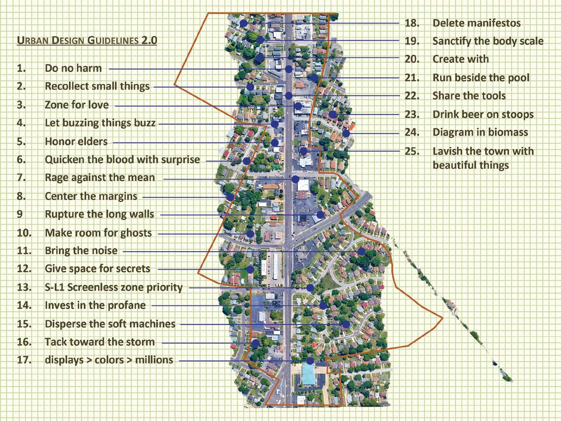 joseph heathcott
Joseph Heathcott is Associate Professor and Chair of Urban and Environmental Studies at The New School in New York. He studies the metropolis and its diverse cultures, institutions and environments within a comparative and global perspective. www.heathcott.nyc
on site review 42: atlas :: being in place 31
Joseph Heathcott
cartographies: decolonised manhattan
 joseph heathcott
COLONIAL ARCHITECTURE
Settler colonial architecture comes in many forms, from the British farm houses of East Africa to the Spanish churches of the 'New World'. In all cases, such architecture takes hold within the process of land enclosure and expropriation on a global scale. Over the past 400 years, this process has been drilled in the notion of property – land and 'improvements' that can be owned in sovereign fee simple. When the Dutch 'purchased' Manahatta from the Lenape for 60 guilders, they imagined it as a property transaction. However, for the semimigratory Lenape, land was part of a radically different episteme, a fundament no more 'ownable' than air or water. For them, the purchase was a gift from the Dutch in exchange for the use of the land for hunting, fishing and gathering. Today, the notion of property, owned and transacted through markets, underpins settler colonial architecture within the capitalist world system.
DECOLONIAL ARCHITECTURE
The shift to a decolonized architecure cannot be realized through form. Architecture is not buildings, but rather a system of relations that pivot around the habitation of land. Thus, architecture after colonialism will necessarily be situated within a reconceptualization of land itself. While new designs might emerge from this shift, decolonized architecture is unthinkable in the context of property markets and the spatial fix of capital. In the case of Manahatta, we propose the re-expropriation of the land to be held in trust by a council of indigenous people. The buildings (once called 'improvements', now called 'allowances') will remain with their owners, subject to comprehensive rent controls. Owners will pay ground rent to the trust for the right to use the land. Proceeds from ground rent will be dedicated to free housing, education and health care for native peoples. The trust retains right of first refusal over the sale of any building, which will be dedicated either to a 'right of return' for Lenape people or to subtraction to restore the land to nature.
on site review 42: atlas :: being in place 32
DECOLONIZED ARCHITECTURE LAND ALLOWANCE PROPERTY
PROGRAM FOR A
:: urban matters
on site review 42: atlas :: being in place 33
LABORATORY FOR URBAN SPATIAL + LANDSCAPE RESEARCH, NEW YORK, NY
PG 1 OF 1
CONCEPT SKETCH
(re)mapping: tracing politics in urban space
lejla odobašic novo and aleksandar obradovic
Street names play a powerful role in the formation of collective and national identities, and in the legitimisation of political ideologies. With a radical formation of a new ruling elite, the renaming of streets, public spaces and public institutions becomes a reflection of the new ideologies. New maps become testaments to a historical narrative always under reconstruction by those in power.
The deliberate renaming of streets in post-communist power shifts are a reconfiguration of space and history, a fundamental and essential element of post-communist transformation, creating new public iconographic landscapes in accord with the principles of the new regimes.
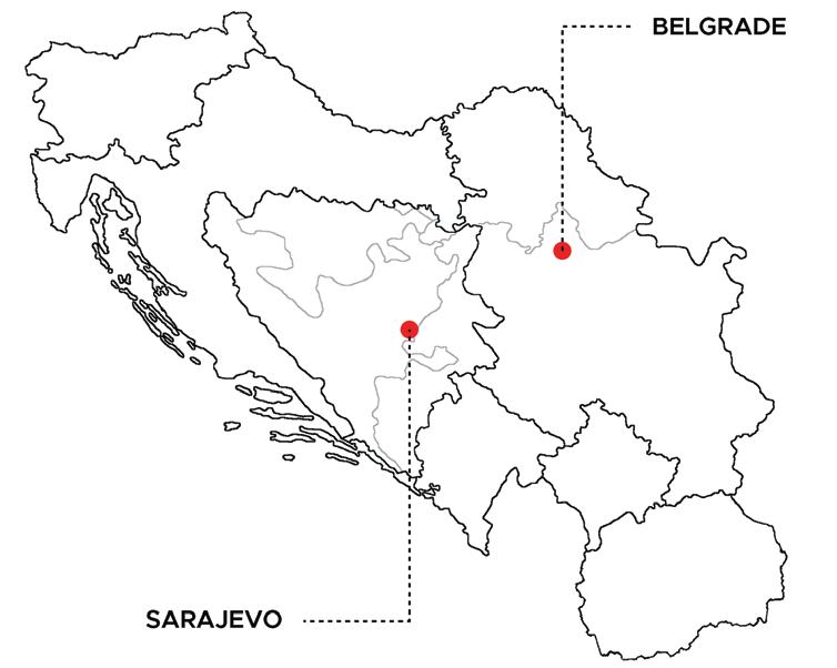
In the former Yugoslavia where street names often celebrated socialist ideals, a series of ethno-national conflicts within its different republics resulted in the fragmentation of geographies and the resurrection of former nationalisms. We looked at two cities, Belgrade (the former capital of Yugoslavia and the seat of Yugoslav power during the 1990’s conflict) and Sarajevo (the capital of Bosnia and Herzegovina, one of the former Yugoslav republics and now an independent country).

Sarajevo was the most heterogeneous in terms of its population and the most reflective of the Yugoslav notion of ‘brotherhood and unity’ in the way its population coexisted; it is the city that suffered the longest siege in modern history at the hands of the Serb forces. After the last war in the 1990’s, East Sarajevo was built under the territory of Republika Srpska almost as an alternate Sarajevo with its own historical narrative that glorifies the Serbian nation.
We analysed the historical undercurrents that defined the name changes in the historic cores of the two cities, and the ways in which the same tools were most successfully used in creating and defining new national identities in both.
The limitation of a study based on the political significance of historic cores is their chronological longevity that withstands political changes. However, these areas play a significant role in the mental map of citizens and thus the formation of collective identity. It is most common that historic centres, buildings, squares, streets, and urban scenes of the capital cities become the image of that nation.
We examined the names of 52 streets and public spaces in Belgrade and 112 in Sarajevo in 1990, just before the fall of Yugoslavia, and then in 2020. In Belgrade, the names of certain streets have changed multiple times in this thirty-year period and some are still in the process of changing. In Sarajevo on the other hand, most changes of street names in the study area occurred between 1992-1995, as the new independent Bosnia and Herzegovina was being formed. The new ideals of autonomous Bosnian identity were rooted in the old historical patterns that attest to that autonomy.
on site review 42: atlas :: being in place 34
´ ´ :: urban matters
Belgrade

When we look at the last 30 years, we see an almost complete de-commemoration of the National Liberation War, the Labour Movement, international co-operation and toponyms from the former Yugoslavia. Political opportunism and waves of revisionism have removed any cosmopolitan spirit from the streets of Belgrade’s core. Changing the names of squares and streets was a tool to silence ideological opponents and establish the value-ideological system of those with power in public space and discourse.

Belgrade’s central streets were filled with old and new heroes, chosen to reflect what was useful for power holders in that historical and political moment. The monarchy, the church, and other ‘verified values of the Serbian people’ got their streets and boulevards. Controversial personalities of both older and newer Serbian history were given their place of remembrance in public space, including the formerly prominent, recently deceased, members of the party.
The constant of the Serbian political elite in dealing with the culture of memory in the last three decades has been mono-ethnic nationalism, a policy diligently pursued by both Miloševic and opposition leaders. The cosmopolitan Belgrade that existed until the end of the 1980s, when it was the capital not only of a multi-ethnic and multicultural Yugoslavia, but also the political centre of the Non-Aligned Movement which gathered a diverse circle of African, Asian and Latin American states, is now completely absent. Central Belgrade now commemorates Serbian ethno-nationalism provincialising the city. The capital of a multi-ethnic Yugoslavia has become the centre of the so-called Serbian world. On the symbolic battlefields of the central city streets, the International Labour and Liberation Movement are lost in the onslaught of revisionist heroes. Belgrade has turned the circle of history. New enemies of the Serbian people are being found again, and this time it’s not just people, but cities.
on site review 42: atlas :: being in place 35
Sarajevo

With the breakup of Yugoslavia and the establishment of Bosnian and Herzegovinian sovereignty in 1992, the renaming of the streets in Sarajevo was part of the deliberate strategy to break away from Socialist ideals and heritage, thus creating a specifically Bosnian history. All the old, ‘negative’ associations were replaced by names deemed to be more acceptable as part of a deliberate reshaping of this particular aspect of place. Through a selective reconstruction of Bosnian history to appease contemporary nationalist aspirations, there was a conscious invoking of a collective memory of both distant and recent events to enhance group identity.
The nationalistic renaming of streets in Sarajevo reflects the Commission’s strong desire, on behalf of the city’s inhabitants, to establish an identity that can contribute to development of a more secure basis for self-government and territorial integrity. Building a new national narrative that highlights the differences between Bosnia and its neighbouring states has emphasised the nation as specifically consisting of Bosnian Muslims, whose awareness of their own distinctive heritage is differentiated from Bosnian Croats and Bosnian Serbs. The same is true in East Sarajevo, where the Serbian national narrative has been hardened. The inevitable inconsistencies in historical narratives and political ideologies between the two parts of Bosnia and Herzegovina makes one question the relationships between ‘state’ and ‘nation’, especially within the context of the former Yugoslavia.

on site review 42: atlas :: being in place 36
:: urban matters
Street names, sensitive pointers to the link between political processes and the urban landscape, are tied inevitably to nation building and state formation. Political ownership of the urbanscape through urban nomenclature is especially susceptible to revision, especially in the wake of major power shifts and regime changes. Toponyms are powerful cultural signifiers and vehicles of memory to which political authorities resort to in their bid to symbolically appropriate space by inscribing into the landscape a self-legitimising iconography of power. The large shift from the common Socialist narrative to localised and national ones, is reflected in the new names of the toponyms of both cities.
Sarajevo’s 1,425 days under seige between 1992 and1996 coincided with its main wave of street name changes. As the Bosnian Serb army shelled the city, the determinants that had connected it to Yugoslavia disappeared from Sarajevo. Belgrade, on the other hand, was not directly affected by the war and changes to its streets came in stages – during the period of the Yugoslav wars (1991-1996), only a small number of streets were changed because Miloševic insisted on prolonging the illusion of Belgrade as the Yugoslav capital.
What is similar in both Sarajevo and Belgrade is how the streets were renamed as a return to a ‘better past’. The meaning of that past differs as much as the history of these two cities, but the principles by which its ‘goodness’ is determined are much the same. Both cities have been flooded with toponyms that refer to personalities and historical determinants important for the construction of the Bosniak and Serb ethnic identity, respectively. Socialism, the labour movement, and the industrialisation which brought economic progress to both Bosnia and Serbia are ultimately rejected, replaced by a mythical golden age of kings and ancient monasteries for Belgrade and traditional Ottoman names for Sarajevo.
The return to a mono-ethnic past has reduced the profile of multi-ethnicity in the narratives of public spaces in both cities. As the national territory shrank, the toponyms in the capitals became more and more exclusive. Ethnic minorities were not desirable bearers of public narrative; their discourse and memories needed to be removed. Other minorities did not fare any better. Insisting on ethnicity and creating a single, narrow identity has closed these cities. They both symbolically and spiritually rejected their cosmopolitan settlement and voluntarily turned into a province.
We are going to extend this study to the remainder of capital cities of former Yugoslavia and to see how the revisionist patterns occurred in Ljubljana and Zagreb (both cities now in the EU) as well as Podgorica (once Titograd) and Skopje. p
Toponyms are divided and subdivided into categories.
pe ople
1 Influential persons in four subgroups: names linked to statehood – presidents, influential politicians, army leaders, kings and nobility, mayors
2 culture-creators and artists – poets, writers, painters, sculptors, architects, persons who have had significant cultural impact, scientists and academics
3 religion – saints, religious orders, priests, bishops, and popes; buildings named after any religious affiliation
4 entrepreneurs
g eographical features
1 rivers, towns, regions, countries, mountains
2 landmarks – railways stations, markets, river-banks
3 traits or attributes such as narrow, steep, wide, long, hill history
1 historical events, institutions, and historical dates (e.g. May 1st International Labour Day),
2 social movements, armies. There is a separate subgroup for streets named after historical events and intuitions within Federal Yugoslavia (SFRJ), as this period played a crucial role in the creation of the names within the 1990 analysis, and the common political narrative of these two cities.
crafts and trades
1 butchers, blacksmiths, millers, weavers
S ome of the street names could be placed into more than one group. If a writer or culturally important person was also a participant in an important political movement the decision had to be made as to the most important role of the person involved: either in the cultural- artistic field, or in the sphere of statehood.
for more information
Interactive maps of the two cities are available at http://remakinghistory.philopolitics.org/ You can also download the full version of the publication in PDF format at the same link.
acknowledgements
This research was generously funded by Tandem for Culture - Western Balkan in cooperation with MitOSt and European Cultural Foundation.

references
Robinson, G.M., Engelstoft, S. & Pobric, A. ‘Re- making Sarajevo: Bosnian Nationalism after the Dayton Accord’. Political Geography 20: 2001. pp 957-980
Light, D. ‘Street names in Bucharest, 1990-1997: exploring the modern historical geographies of post- socialist change’. Journal of Historical Geography 30, 2004. pp154-172.
Đordevic, N. ‘Serbian World — a dangerous idea?, Emerging Europe’2021. (accessed 6th September 2022), https://emerging-europe.com/news/serbian-world-a-dangerousidea/
Lejla Odobašic Novo is a Bosnian-Canadian architect licenced by the OAA. She is currently teaching as an Associate Professor at the International Burch University, Department of Architecture in Sarajevo. Her research lies at the intersection of culture and politics, exploring how this junction manifests itself through architecture in contested spaces.
Aleksandar Obradovic is a cultural anthropologist and founder of the Philopolitics think tank. He is a non-academic researcher in areas of urban space and political anthropology. His research is focused on the relationship between public space and power, as well as minority narratives that contest mainstream narratives and appropriation of public spaces.
on site review 42: atlas :: being in place 37
´ ´´
e xchange
francesca vivenza
Michel Boucher
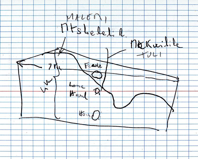
I found this small sketch in one of my husband’s field books labelled N ONTARIO – DIMENSION STONE/KENORA CAMP/15 – 21 SEPT 1986
It is a rough field draft drawn as base map for some geological work on a piece of land 7 x 4 km wide.

Fascinated, I asked him to confirm the location. I was stunned to find the little map is actually a piece of Zimbabwe. I interpreted it as a funny mishap, Zimbabwe in the Kenora region. At the same time, this has given me a sense of geographic, ecological disorder and instability: a connection to the North-South exploitation on our planet.
My husband has inadvertently created a space of exchanges between Kenora and Zimbabwe, two exploitable territories for their mineral resources, one on the North and the other on the South of the globe, both with a colonial history.
This new place, if disturbing, I find quite disarming. That which is not possible in geography, might be possible with art.
Francesca Vivenza is a Toronto based mixed-media artist whose works on paper, exhibited internationally, include maps. Focusing on the transformation of the old into the new, her works address themes of travel, migration and displacement. www.francescavivenza.com
on site review 42: atlas of belonging 38
:: mysteries
an uncertain proposition
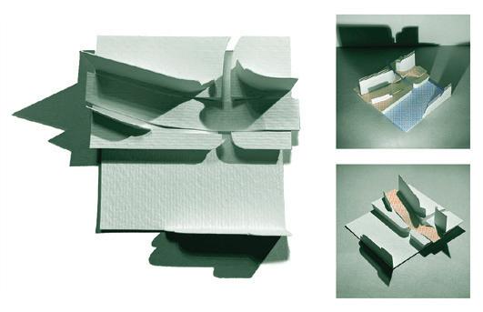
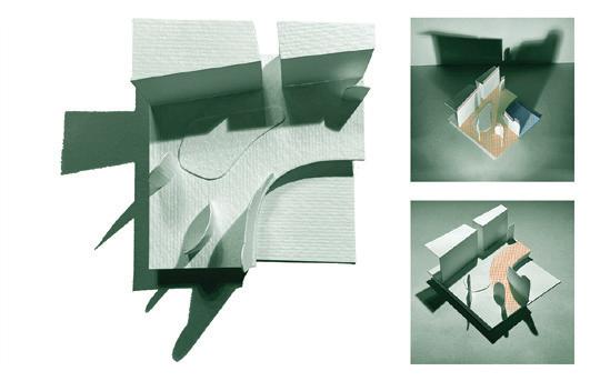
patrick mahon , thomas mahon
Mazes are contexts where to be momentarily lost can be both pleasurably distracting and troubling; a predicament to be negotiated, where location involves much speculation.
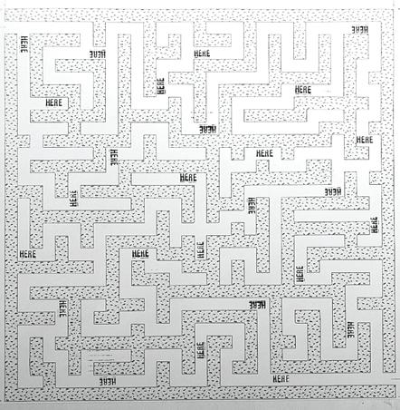
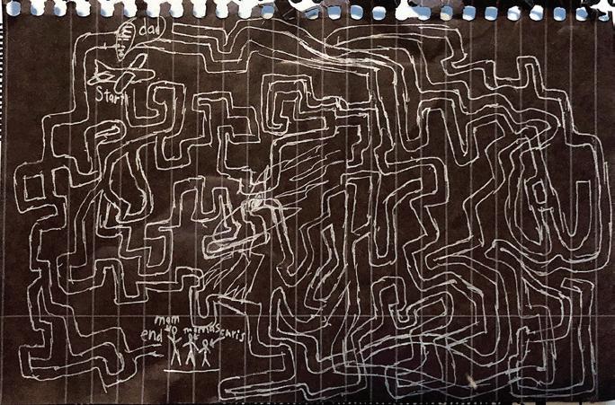
David Wagoner's 1971 poem 'Lost'1 shows how we might locate ourselves:
Stand still. The trees ahead and bushes beside you Are not lost. Wherever you are is called Here, And you must treat it as a powerful stranger, Must ask permission to know it and be known. The forest breathes. Listen. It answers, I have made this place around you. If you leave it, you may come back again, saying Here. No two trees are the same to Raven. No two branches are the same to Wren. If what a tree or a bush does is lost on you, You are surely lost. Stand still. The forest knows Where you are. You must let it find you.
The tiny 4 x 6" drawing by Thomas when he was eight years old shows an airplane flight that Patrick took in 2000. No negotiation, just departure and arrival and confusion in between.
B oth the poem and the drawing were made when our planetary environmental crisis did not loom so large. We are adding another piece, an imaginary leafy maze. Its walls are endangered plants and trees. To stop in this ordered but existentially fragile maze is a moment of incommensurability: one is neither here nor there.
and fosters hopefulness. www.patrickmahon.ca
Thomas Mahon, a designer and architect based in Brooklyn, has worked across a wide range of projects and media, from graphic design to urban scale initiatives and master plans, with an interest in ecology and environmental equity.
on site review 42: atlas of belonging 39
Patrick Mahon, artist, curator and professor of Visual Arts at Western University, is committed to art as a vehicle of contemporary expression that helps imagine transformation
1 Wagoner, David. 'Lost' (1971) Poetry Magazine. Chicago: Poetry Foundation, 2022. p 219
p
Flight Maze
Here Maze
Leafy Maze
unmapping maps
 lisa rapoport
Mapping is an act of curation, a sorting out of actual lived experience into a series of assembled components that combine into a systematic narrative that we learn to understand and assume is the organisation of the experience. As an architect, urban designer and teacher, I have come to trust this desire for organizing principles, the results being so easily analysed. But my experience of moving through space is much the opposite – haphazard, coincidental, haptic, with many narratives colliding, unconscious, and dominated by time. A map implies time only by distance, without the mess of wandering, pondering or traffic.
Though a city may be organised on a grid, my movement across it may include cutting corners, making diagonal paths, hopping into and through buildings that join streets – anything but linear. My mental map is made of these ingrained routes and shortcuts along with personal markers (where so-and-so lived, where I fell off my bike…); so much more than the organised structure of a street map. This extends to all spatial experience: though I know that the sun is an object at the centre of a series of orbiting planets including earth, and therefore I
am the one moving, I still say the sun rises in the east and sets in the west. Astronomical knowledge simply does not match up to my actual experience of the sun.
In previous articles for this magazine1 I discussed PLANT’s work that focused, in defiance of distillation of place for easy mapping, on the slow revelation of a place by walking, the sense of discovery, savouring the recitative of the spaces in-between more consumable high points more easily mapped. More recently I have started to look more deeply into the facts and physicality of the map itself, trying to understand exactly how a common map fails to capture actual experience of place. A map doesn’t even acknowledge whether you are coming or going – such a fundamental part of our experience of a place. The two projects here map driving experiences to show this. I think of these as unmapping projects – pulling the map and our experience apart, but not really trying to put it back together again. These unmappings unravel experience and revel in the undoing.
1 'Every Walk is Unreproducible' in On Site review 31: mapping | photography, 2014 and 'Material Memory' in On Site review 36: our material future, 2020.
blink and you miss it
In 2016, La Maison de l’architecture du Québec (MAQ) commissioned six teams to create solutions to explore and improve the experience of Québec’s Autoroutes for the exhibit S.O.S. Paysages Autoroutiers
Together with poet Ronna Bloom, PLANT explored Highway 10 in a project we called Blink and you miss it. Ronna and I had grown up in Montreal with cottages in the Eastern Townships, and along with my partner Chris Pommer, have had decades of driving this route. This was an opportunity to understand the highway in retrospect. We started just looking at the road map – something I had never done as this was a habitual family drive; we never needed a map. The route had so many inexplicable zig zags – a logic we assumed came from property lines, but even more curious was a regular pattern of bumps in this otherwise flat landscape.
No. 10 is the Highway to the Eastern Townships –the highway to the mountains – the Appalachian Mountains. No. 10 is the highway that passes by and between a set of mountains – not a chain like the Appalachians or the Laurentians, but a sequence – each a singular and bold eruption from the St. Lawrence lowland plain, a totemic sequence –mountain, space, mountain, space….
Blink and you miss it was our proposal to bring the driver and passengers’ attention to the sequence of mountains, both factual and poetic, at high speed and at rest. The project places the driver precisely in a 140km narrative in relation to the passage of these mountains, in three distinct interventions shaped by speed. These are each a way to bring the order of the map to the real space and time.
on site review 42: atlas :: being in place 40
:: mysteries
There are mountains; there is a sequence (East)
Head east toward the weekend on Highway 10. You have driven this route so many times you barely notice the turnoffs marking miles, kilometres towards getting there. Towards sleep or rest or walk, or build or ski. Air or mountain.


You get a note from the architects of the universe saying: you are passing history on your left, on your right quicker than you register, faster than the signs for exits, casse croutes. There are hills older than a hundred million years the magma rose and cooled and displaced crustal rock.
Mont Oka, Mont Royal. With their hidden plumes of light, intrusions in the plain, mouths of earth pressed up against the sky. Mont Saint-Bruno, Mont Saint-Hilaire and space for air and road and farm. These hills –– you've heard their names before ––or live there –– or walked them as a child –– Mont-Saint Gregoire, Mont Rougement, found leaves or apple orchards, uprisings, forests. Mont Yamaska, Mont Shefford, and a car speeds by, a truck. Mont Brome, beyond the belted Appalaches Mont Megantic. The line, the lineage of mountains aligns you to and from the ville, There before the city and after, still there waiting, their language plumes up in whispers saying, attend, attendre, even as you pass.
— Ronna Bloom, 2016
the experience
Driving this highway at 120 km/h with its distinct angular changes of direction zig-zagging between seigneuries, we can’t tell how many mountains there really are, or which mountain we are looking at. We assume singular mountains are just foothills, eventually gathering boldly together to be the Appalachians, or, returning home to Montréal, that the mountains are slowly petering out like splatters from the real mountains – as if mountains do that. But the real narrative is much better: No. 10 follows the route of seven of the nine Montérégian mountains – Mount Royal, Mount St. Bruno, Mount St. Hilaire, Mount Rougemont, Mount Yamaska, Mount Bromont, and Mount Shefford – each linked by heat on the Great Meteor Hotspot Track. Every school kid is taught (incorrectly) that Montréal is a dead volcano, and although each of these mountains do follow the same fault line, each were created by magma pushing up to create an almost-volcano – its structure made not of horizontal strata, but distorted vertical strata. The whole St. Lawrence plain was volatile. The mountains are linked below the ground to the centre of the earth, but we see them as separate, singular, and enigmatic – holding their own against the erosion of the plain. They are not the Appalachians –they are distinct.
At 120km/h the mountains present themselves in three to thirty-second glimpses. They are like ships on the vast horizon of the plain, but at 120 km/h, with only a fleeting flash in the driver’s peripheral vision, blink and you miss it. The passengers can point – look over there, and there is another one! Which one did I just pass?
120km/h mountain identification Montréal to Sherbrooke: At km 1, the driver is both informed and warned – There are mountains. There is a sequence. Blink and you miss it. Each mountain is identified with a sign made of individual letters pre-warning the driver of the view to come, calling to the depth of the plain: kilometres before, the letters seem scattered between the roads, in the field – near and far, a jumble calling for the attention of the driver – all of a sudden, they coalesce moments before the mountain is seen. Like the bronze pointers at Mount Royal’s Scenic Belvedere lookout (the first mountain in the sequence), they point to and identify these key markers in the landscape.
on site review 42: atlas :: being in place 41
1
PLANT
2 An ode to the mountains: There are mountains; there is a sequence (East)2 is embedded in the roadbed to be read one word at a time at 120 km/h – in English Montréal to Sherbrooke, and in French Il y a des montagnes, il y a une séquence (ouest))3 de Sherbrooke à Montréal. Each word, 642 metres apart, is painted in road paint as an anamorphic illusion to render it readable from the driver’s one point or view, and appears to float in front of the driver.


3 0 km/h mountain encounter Sherbrooke to Montreal: Look-outs with view stations combine a bench and identification panel that aligns with the mountain and its geology below grade. The view station positions the viewer precisely in relation to the mountain and embeds the viewer with the geology of the mountain form in the plain.

on site review 42: atlas :: being in place 42
1 2 3 :: mysteries
PLANT
Il y a des montagnes, il y a une séquence (ouest)
Prenez la 10 vers l’ouest vers la ville Puisque ce chemin vous est si familier vous apercevez à peine les tournants où l’on voit combien loin est l’arrivée. La maison familiale, les lumières des bureaux, le boulot, la semaine vous attendent là-bas.
Vous obtenez une note des architectes de l’univers indiquant que vous traversez l’histoire sur votre droite, plus rapidement sur votre gauche, plus rapidement que ce que vous percevez, plus rapidement que les indicateurs de sortie, les casse-croûtes. Certaines collines font plus de cent millions d’années le magma rose et refroidi et la mouvance sédimentaire de la croûte.
Mont Mégantic s’offre à vous, puis Brome. Avec leurs plumes de lumières cachées, les intrusions dans la plaine, bouches de terre accolées au ciel. Et puis mont Shefford, mont Yamaska, et une étendue pour l’air et le chemin et la ferme. Ces collines – leurs noms vous sont familiers – peut-être même vous y habitez – ou, jeunes, vous les avez parcourues – mont Rougemont, mont Saint-Grégoire feuilles ramassées ou vergers de pommes, soulèvements, forêts. mont Saint-Hilaire, mont Saint-Bruno. Et un camion passe à grande vitesse, une voiture. mont Royal suivi du mont Oka. La ligne, la lignée des montagnes vous enlignent vers la ville, vous y éloignent, là, avant la ville puis après elle, toujours en attente, leurs langages foisonnent en chuchotements attendez, attendre, murmurent-elles, au moment-même de votre passage.
 — Ronna Bloom, 2016
unmaps
We explored alternate ways to map this experience: Our installation included large scale maps (each mountain in 3d) trying to describe the sequential mountains seemingly shifting constantly in view because of the zig zagging of the highway, but the maps seem to show an order and clarity not easily perceived in real experience. How else could we map this experience – these visual flashes, the geology, the sense of escape from, and the return to, the city?
Our attempt was poetic and cinematic: Ronna wrote two poems – There are mountains; there is a sequence (East)1 and (ouest) 2 – one coming and one going, which conflate all aspects of the experience – a poetic narrative that maps the journey. And, we made a three hour documentary film (the time it takes to drive there and back) showing four simultaneous views of the highway seen while driving, as if you were rubbernecking in all directions at the same time. Here we could see each mountain coming into the view on the left, disappearing, and then after a long pause, appearing on the right (or was that a different one?) as we turned. We could also see that even in film with time stretched out, it was confounding – the mountains seemingly never staying still and knowable.
 p PLANT
Chris Pommer, Lisa Rapoport and Mary Tremain founded PLANT in 1994. Now a team of architects, landscape architects and designers, we make personal and public spaces committed to building communities – one living space, one workplace, one public space at a time. https://branchplant.com
on site review 42: atlas :: being in place 43
ahead
behind out the driver's side out the passenger side
unmapping thunder bay
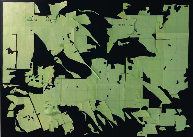
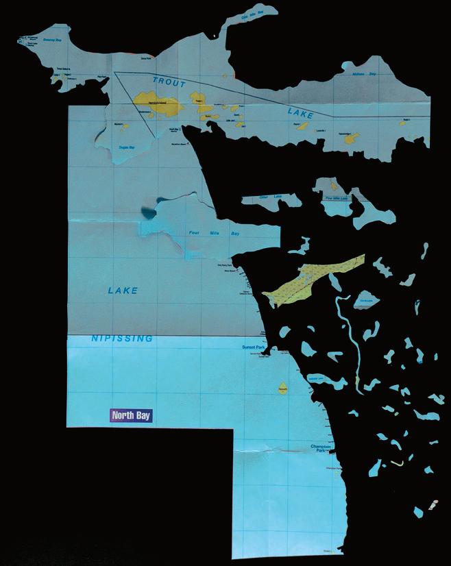 lisa rapoport
For the last six months I have been undoing a Canadian Automobile Association map of Thunder Bay. I have driven through Thunder Bay many times driving from Toronto across Canada and back, and had a vague mental map of it, but more as a way-station on very long drives across a quintessential Canadian landscape.
Until GPS and Siri narrated our journeys, CAA and other touring maps were the foundation of travel organisation with their clear symbols and colour legends neatly breaking down each place into fixed components. I decided to make a project of manually cutting out every landscape claimed by use in the map – parks, parking, golf courses, open mines and cemeteries – and organised them by taxonomy into new mappings where I could contemplate their curious shapes and sizes, literally detached from their adjacencies, and their reason for being.
The vast majority of the area remaining was built form, undifferentiated areas of green – textureless areas of landscape which appear to be unoccupied because they have no function to name in the map, and blue –named and unnamed waterways. Lacking in named functions, these areas are portrayed as uninhabited/ useless – though experience here would show these have been inhabited/useful for millennia and continue to be occupied.
The built form of the city (pink) remains as a sinuous contextless experience on paper, its road and internal logic completely disengaged from the landscape – the woods, hills, stone outcrops and patterns of ownership that define, restrict or direct movement, views, or city growth. Perhaps this is closest to how we might understand a city in a map as we are planning a driving route – detached, completely devoid of real experience.
Cutting the map out by hand was laborious, precise, and slow, in defiance of the apparent efficiency of the map. For me, it created an armchair trip to Thunder Bay that wandered haphazardly and slowly, unconsciously lacking a fixed route, and yet was a rich experience filled with curiosity and exploration of this place. This process brought time into the map, creating an analogue of wandering around a landscape and discovering odd corners and details, beginning the process of building a map of this place in my mind. p
on site review 42: atlas :: being in place 44
:: mysteries PLANT
far left, top: green – undifferentiated landscape bottom: blue – water
this page, top: clockwise from upper left: parking lots, parks and cemeteries, golf courses, open mines below: pink – built form
Lisa Rapoport is a founding member of PLANT, an architecture and landscape architecture studio in Toronto, working across Canada and internationally. https://branchplant.com
on site review 42: atlas :: being in place 45
PLANT
the certificaat
yvonne singer
A red line. I stare at the map. It looks so simple; a flat outline of water and land, fragments of western Europe, Africa, North America in light beige and shapes of blue grey waters in between designating the Atlantic ocean, the Mediterranean and the Great Lakes. Words are grey blue like the water. Key ports are in black, with touches of orange for the Orange Line. There are no co-ordinates the ship can use to navigate on this certificaat. I guess this is not its purpose.
On the cover of the certificaat is a line drawing in blue grey of Neptune’s bearded face, semi-hooded eyes looking in the distance, his muscular torso in the water, holding his three pronged trident in the left hand and with the other hand, pointing to the line drawing of a ship on the horizon. He looks like a middle-aged patriarch with his long beard. Neptune’s mascot, another line drawing of a cod, a fish common in the North Atlantic, is in the lower right hand corner beside the logo of the shipping company, the Orange Line in ornate orange script.

Using google translate’s awkward translation, I translate the document to discover that Neptune is taking me across the ocean.
It has pleased Neptune, God of the Sea, Ruler of the Oceans, etc.etc, to issue this certificate to Yvonne M.E. Vandor (carefully handwritten) on the occasion of crossing the North Atlantic from Rotterdam to Montreal in the month of July 1949 with the m.s. Prince Johann William Friso. It has further pleased Neptune, after meeting with his counselors, to award the sea-fastness rating the figure 8. Thus done in the year of our honor, 1949, July, at Gulf of St. Lawrence.

Neptune and his Counselors
Below are three different indecipherable signatures with no titles. Neptune’s counselors, perhaps?
On the back in blue: a list. Degrees of Seamanship
According to this chart, Neptune is awarding me an ‘8 = good sailor’. What an honour to be personally escorted by Neptune and to be awarded an 8 for being a ‘good sailor’. How do I thank you Neptune? Mr. Neptune or is it Sir or maybe King Neptune. What is the proper way to address a god? This is like getting a letter from Santa.
below, clockwise: the front cover of the certificaat: Neptune; the back cover with the degrees of seamanship; the inside of the certificaat

on site review 42: atlas :: being in place 46
:: emigration
I was five years old when we arrived to Montreal in 1949. A memento of the trip, the certificate, tells us that the ship was called the Prins Johann Willem Frisco, part of the Orange Line. What it does not tell us is that the ship was a freighter with only 12 passengers and my family were four of the 12 passengers. It also doesn’t tell us that we were emigrating to Canada, leaving post-Holocaust, war-torn Budapest, Hungary, our Jewish identity, our past. I have no memory of the trip or the arrival and I did not know about my Jewish identity for many years. But I have this certificaat my mother kept and gave to me. For years, it languished in a filing cabinet, a curiosity that I just filed. By the time I re-discovered it about two years ago, my mother had died.
There is no one to ask…no one left of the handful of family and relatives to ask… how/why did you choose to travel on a freighter? Why that freighter? Why depart from Rotterdam? Who were the other passengers? Who took the photo of our family at the railing as the ship left port? How much luggage did you have? How much money did you have? What did you bring with you besides clothes for you and the two young children? How was the voyage ? Did you get seasick? Was there a doctor on board? What did you eat? Where did you eat? What was the food? So many questions…so few answers.
I look at the map and I see my name and I feel very distant from it…like it is someone else’s story.
I search the internet and to my surprise I find a photo of the ship, MS. Prince Johann William Friso from the Orange Line. It is not a very large ship as freighters or oceanliners go. The photo seems to make it more real to me than the certificaat. It is evidence the certificaat belongs to the ship.

I remember my first English words, standing on the small balcony of our second floor duplex, I call to the girl I see next door. “What is your name?”
Walking to school; ‘step on a crack, break your mother’s back’. They call me names and taunt me by insisting I stepped on a crack and then running away.
What did that certificaat bring about? That fateful trip, the choices made.
Fresh start, new life, new country, new language, new identity…who will know anyway; a decision is made, a choice is made. A choice that will haunt them and boomerang….I am their nemesis. In my innocence I converted to Judaism to marry my Jewish husband, then discover I am Jewish by birth, my rightful birthright as established through my Jewish parents and grandparents. I find proof in the Budapest synagogue records…but this fact is never acknowledged. I am trying to map my past, to navigate my history. What are my co-ordinates? How do I navigate? Who is my guide and protector?
There are so many stories; people fleeing, escaping, hoping, fearing, searching. p
https://www.shipspotting.com/photos/1543705
Yvonne Singer, born in Budapest, Hungary, is interested in everyday language and the intersection of public and private histories. Her installations employ multi-media techniques, often with cryptic texts using everyday language to articulate issues of disjuncture and perception. www.yvonnesinger.com a disturbance of memory, http://artmetropole.com
on site review 42: atlas :: being in place 47
MS Prince Johann William Friso, Orange Line, Rotterdam
uncertain cartographies of belonging
A rabic-speaking immigrants in early twentieth-century U nited S tates
salah d hassan
Descendants of turn-of-the-century Arabic-speaking emigrants from the former Ottoman Empire inhabit an ambiguous space of cultural belonging in the United States. Contemporary Arab-American presence is troubled by erasures and hostility. At the same time, Arabs lay claim to a 150-year history of immigration and the achievements of the so-called pioneers. Philip K. Hitti noted in his 1924 Syrians of America, that 89,971 Arabic-speaking immigrants entered the United States between 1899 and 1919 and settled in communities across the continent. In the introduction to the first edition of Hitti’s book, Talcott Williams, an American journalist born in 1849 in Ottoman Syria, claimed that ‘I know no American city where I have not spoken Arabic and no port on the Gulf or the Caribbean where the Syrian is absent’. In the early twentieth century, Syrian immigrants left their towns and villages in the provinces of the Ottoman Empire and travelled, often in steerage, across the Atlantic. The majority arrived at Ellis Island for immigration handling and then entered the country through New York Harbour. By 1890, they had established a Manhattan ethnic neighbourhood known as Little Syria on Washington Street between Battery Place and Rector Street.
The history of Little Syria is a testament to the presence of Arabicspeaking immigrants at the centre of modern metropolitan American cultural and commercial life. In 2013, the Arab American National Museum in Dearborn prepared a special exhibit titled Little Syria, NY: An Immigrant Community's Life and Legacy that was later installed in 2016 at the Ellis Island Museum. The exhibit emphasises the largely erased Arab past in lower Manhattan, and also looks beyond the metropolitan gateway. Included is a 100-year-old Arabic-language map of the United States; labelled the Peddler’s Route Map, it represents the dispersal of Little Syria peddlers in their journeys to far-flung rural locations. Hitti historicised this view of Syrian settlement across the United States:
Between 1885 and the [1893] Chicago exposition, the flow of emigration was augmented to such an extent that it spread itself all over the country east of the Mississippi and north of the Ohio River, and found its way into the Pacific coast without intermediate stay. But the movement did not assume large proportions until the early nineties...Once started the wave was never checked. The Lebanon furnished the pioneer migrants and the bulk of later emigration, but all portions of Syria and Palestine contributed to the westwardflowing stream.
Indee d, the legacies of other Little Syrias can be found in provincial cities and towns across the country often in unexpected places. For example, a 'Little Syria on the Wabash' historic marker in Terre Haute, Indiana reads: ‘Arabic-speaking Christian Syrians…began their lives in this city as poor pack peddlers and with their savings many bought houses and became grocers’. The marker concludes: ‘Many original families are here today’, reclaiming an Arab presence in the United States that was otherwise forgotten. It also offers a development narrative for a community that transitioned from foreign (Arabicspeaking pack peddler) to familiar (Christian homeowner and grocer). That the first Terre Haute Syrians were Christian, that they saved money, shed their peddler past, bought homes and started businesses are central elements to Arab-American belonging in that midwestern town on the Wabash River.

on site review 42: atlas :: being in place 48
:: emigration
Little Syria, in the Lower end of Manhattan, in Rider's New York City, Henry Holt and Company, 1916.
University of Texas Libraries
The Peddler's Route Map, in Arabic, 1920. Sallum Mukarzil, Tarikh as-Tijara al-Suriyya fi-lMuhajara al-Amrikiyya. New York: al-Matha'a al-Suriyya al-Amrikiyya, 1921.
Salloum Mokarzel and the Peddler’s Route Map
The Peddler's Route Map was first published in Salloum Mokarzel’s 1920 The History of Syrian Trade in the American Migration. It provides an entry into the complexity of Arab-American belonging and raises questions about the changing cartographies of the United States and Syria: What did the Peddler's Route Map signify in 1920 and what does it represent 100 years later? We can read the map in relation to Arab presence and also in terms of un-belonging, as the Peddler’s Route Map calls forth the maps of the United States and Syria in the period between 1890 and 1920.

Salloum Mokarzel (1881-1952) contributed to the development of the Syrian American press through several Arabic-language newspapers in the early twentieth century. His publications included the 1909 Syrian Business Directory and the Syrian-American Commercial Magazine (1918-26). He ran the Syrian American Press, publishing newspapers, magazines and Arabic-language books, including History of Syrian Trade in the American Migration He patented an Arabic-language linotype machine in 1910, which produced a notable increase in newspapers and magazines in Arabic printed throughout the Americas, playing a crucial role in connecting Arabic-speaking immigrant communities across borders and sustaining bonds to their homelands, especially in the 1910s-20s.
Mokarzel, a modern publicist for Syrian American entrepreneurial and commercial activities, was situated at the intersection of early twentieth-century Syrian-American intellectual culture and commercial ventures, advancing a particular modernist sensibility committed to innovation, productivity, profit and progress. From this perspective one can see the influence on Syrian immigrant formations in the Americas of the nineteenth century Arab nahda, variously translated as Arab awakening or Arab renaissance. The nahda emerged in opposition to a reforming Turkish nationalism imposed on Arab subjects of the Ottoman Empire. Nineteenth-century Arab intellectuals, publishers and journalists, writers and poets were the primary advocates of a
cultural revival associated with the nahda and its modernising impulse, transforming Arabic language and generating a previously nonexistent sense of Arab national feeling in the decades prior to WWI. Immigration from the declining Ottoman Empire to an ascendant United States in the late nineteenth century can also be understood as a postnahda effect. For immigrants like Mokarzel, America was the locus of cultural becoming in opposition to repressive Ottoman rule. For other immigrants, the United States was a place of estrangement. In 1908, Khalil Sakakini, a Palestinian intellectual, wrote in a letter home during his year-long sojourn in the US, ‘that America is worth seeing but is not fit to be a homeland [la taslah an takun watanan] for us, for it is a nation of toil, and there is no joy in it.’ In contrast to Sakakani, who returned to Palestine in 1909, Mokarzel embraced the opportunities of modern US business and promoted commercial pursuits as the pathway to belonging.
The History of Syrian Trade in the American Migration focuses on Syrian-owned businesses in cities on the east coast of the US and includes dozens of photos of factories, mills, offices and shops in New York, New Jersey and Connecticut. Images of fashionable men and women in modern well-appointed places of work contrast with the folkish and often racist representations of Syrian peddlers in early twentieth-century American magazines. There are no photos of peddlers in the book, only the Peddler’s Route Map in one of the last sections. Its title reads: ‘Syrian migrants in the United States. Map showing details of the history of Syrian peddlers in the American migration [mahjar]’. State names are transliterated into Arabic; major cities are noted; dots represent smaller centres. Three arrows point beyond the United States: north to Canada from New York, south to Mexico from Texas, and to the Caribbean and Latin America from New Orleans. There is no date or attribution to a source on the map itself. Trajectories of travel depicted by the arrows suggest that peddler’s routes most certainly correspond to existing rail or roads traced on maps of the United States.
on site review 42: atlas :: being in place 49
James Ansara Papers, IHRC208, Immigration History Research Centre Archives, University of Minnesota
Cartographic representations of the continental United States proliferated, especially with increased automobile travel and the continual expansion of roadways based upon the old trails of a westward expansion fuelled by the ideology of Manifest Destiny. In the early twentieth century, American automobile organisations lobbied the government to build a continental highway system. In 1911, the International Good Roads Congress met in Chicago and endorsed a transcontinental route from New York City through Chicago to Kansas City, then along the historic Santa Fe Trail to Phoenix and Los Angeles. The National Highway Association printed a map in 1914 that proposed 50,000 miles of national highways to facilitate coast-to-coast travel as an alternative to the Panama Canal route. In 1916, President Woodrow Wilson signed the Good Roads Act, making federal funds available for building highways. A L Westgard, a surveyor for the railroads in the nineteenth century, was considered ‘the premier ‘pathfinder’ of the early automobile days’; he was later appointed a Special Agent of the Office of Public Roads. The American Automobile Association published booklets and maps based on the notes that Westgard made during his transcontinental travels along the Old Trail Roads – his ‘Motor Trails from Atlantic to Pacific’ in a June 1919 issue of The Independent shows a close approximation of the four major routes from east to west on the Peddler’s Route Map. A national highway network would facilitate touring the country and visiting historic sites. Although the railroad played a crucial role in the colonial settlement of the western frontier, the building of a federal highway system was the basis for consolidating the nation.

Emerging from WWI as a rising world power, the territory of the United States came together through the national network of road and rail; conversely the homeland of Syrians was dismembered after the war. The geo-cultural and ethno-national significance of the term Syrian and the political geography of Syria were dramatically altered in the decades following the war. The 1906 Lippincott’s New Gazetteer gives the following detailed description (paraphrased) of pre-war Syria: ‘a country … forming part of the Turkish Empire. It extends eastward from the Mediterranean Sea to the river Euphrates and the Syrian Desert, … southward from the Alma-Dagh … to the frontiers of Egypt (Isthmus of Suez). ... It comprises the vilayet of Syria, … Damascus, the vilayet of Beirut, the SW. part of the vilayet of Aleppo, and the mutessarrifliks of Jerusalem and the Lebanon. Palestine is included in Syria ...The designation Syria is sometimes used in a wider sense ... The country embraces nearly the entire E. coast of the great eastern arm of the Mediterranean Sea’. These lands in Arabic were called Bilad ash-Sham; in English, Syria, as in Hitti’s book, The Syrians in America, or in Mokarzel’s The History of Syrian Trade in the American Migration. The postwar remapping of Syria was based on the 1916 Sykes-Picot Agreement between the British and French who set the international borders of the contemporary nation-state of Syria, separating it from the territories that would become Lebanon, Palestine, and Transjordan. Lebanon, a narrow coastal strip along the Eastern Mediterranean (blue on the map) was detached from Syria (reduced to Area A on the map), which were subject to separate French colonial administrations. Ultimately, Palestine (brown on the map) and Transjordan (Area B) were also cut off from Syria and placed under British colonial administration.

Although turn-of-the-century Arabic-speaking immigrants to the United States self-identified as Syrians, Hitti noted that, ‘Before 1899 the Syrians, as such, did not exist for the United States immigration authorities, having been hitherto classified with Armenians, Greeks, Arabs and Turks under Turkey in Asia.’ Subsequently, the term Syrian was reserved specifically for those people living in Area A, the future borders of the Syrian Arab Republic. In early twentieth-century USA,
'Arab' referred specifically to the people residing in the Arabian Peninsula. It is only in the 1940s that the ethnic category of Arab American came into use, and more widely claimed in the post-1960s era through participation in the civil rights movement and post-WWII Pan-Arab anti-colonial politics.

on site review 42: atlas :: being in place 50
:: emigration
Ottoman Syria: the land from the Taurus Mountains to the Sinai Peninsula to the Euphrates, not including Upper Mesopotamia. The Atlas of Ancient and Classical Geography by Samuel Butler, 1907.
AAA Road Map, used to illustrate 'Motor Trails from Atlantic to Pacific' by A L Westgarde, in The Independent, June 19, 1919.
League of Nations Mandate Territories: French Lebanon and Syria (1923-45), British Palestine (1923-48 and TransJordan (1923-25).
The Treaties of Peace 1919-23. NY:Carnegie Endowment for International Peace, 1924
Sykes-Picot Agreement, 1916. This map was a proposal that influenced the border settlements of 1921. In the context of ongoing post-WWI disputes, Syrians resisted partition, the Repulic of Turkey asserted itself, and the newly established Soviet Union refused to cooperate with Imperial powers. The border of the British and French Mandate territories have now solidified, the colonial carve-up of historic Syria conditioning politics in the region since the 1920s.

Historical accounts of Arabic-speaking immigrants emphasise peddling as their primary occupation – a common-sense explanation for the dispersal of Syrians across the United States, the peddler thesis.
The peddler was such a pervasive figure of the Arab other that he appears in literary works as a pseudo-exotic persona. Glenn Ward Dresbach’s 1924 poem 'The Syrian Peddler' is thoroughly orientalist in its structuring of the tension between the stealth peddler and the men hard at work in the fields, and its reliance on romance between the peddler and a farm girl. The peddler is an illusionist, who 'Quickly spread his wares upon the floor,/Peddler-wise'. 'Brightcolored silks and laces billowed out/in airy grace and skillful hands', which mesmerise the naïve girl. The cunning Syrian peddler is the seducer, and the lonely farm girl is his potential victim. Here is not just the pernicious othering, but reductive over-emphasis on peddling, neglecting the greater number of Syrians employed in other occupations, notably the many women in the textile mills of the US northeast. In the 1960s, Arab American folklorists proposed the peddler thesis, the pursuit of untapped markets in the interior of the USA to explain the spread of Syrians beyond urban centres and more importantly to recover the peddler. The peddler thesis asserted belonging in the wider country redefining as an origin story a stigmatised aspect of Arab American history. Rather than presenting the Syrian peddler as a beggar, a huckster, or a cheat, Arab Americans have reclaimed the peddler as a tireless worker who courageously ventured into the heartland of America with little more than a pack of wares and dogged determination, laying the foundation for all the Little Syrias of twentieth-century American cities.

For twenty-first century Arab Americans the Peddler’s Route Map is a visual representation of Arab migration contemporaneous with the spread and settlement of Arabic-speaking immigrants across the United States. The map is a confident cultural self-representation of Arabness at
time when Syrian immigrants had achieved public presence throughout the territorial expanse of the nation. The map indicates the extent of early twentieth-century Arabic language across the country transforming the United States into a place where Arabness fits within the borders of the nation, a testament to cultural belonging, communicated from the past to the present. This proof of historic presence translates across time into a certificate of contemporary Arab-American belonging.
However, presence does not necessarily produce a sense of belonging—that seamless correspondence between the self and a place, or an unquestioned relationship between cultural identity and social space. Implicit in the notion of belonging is an ethics of possession – a place belongs to people, and these specific people belong in that place. Immigrant narratives are always about unbelonging: dislocation from a place of belonging and dispossession of one's belongings.
on site review 42: atlas :: being in place 51
Syrian pack peddler from Birmingham, Alabama, circa 1890.
Faris and Yamna Naff Arab-American Collection, National Museum of American History
postscript
Sam Hallick was my maternal grandfather; his Arabic given name was Hussein Shousher. The family knew that he had lived in South Dakota, that he had married twice during his twenty-year stay in the US, that his second wife in the US was Ayshi Jabbara from the town of Joub Jannine, and that Sam Hallick and Ayshi Jabbara had an American-born son, named Mahamed S. Hallick (aka Mike). An online image of a gravestone in Sioux Falls, South Dakota discovered by one of my brothers displays an epitaph reading ‘Ashey, Wife of Sam Hallick, June 1886-Jan 21, 1919’ with Quranic inscriptions in Arabic. This photo of the gravestone has great significance for our extended family and calls forth our not-so-distant immigrant past. The Sam Hallick of Sioux Falls narrative is both a sentimental retelling of family folklore and a snapshot of a significant modern Arab Muslim immigrant presence in early twentieth-century South Dakota. Sam Hallick spent the first two decades of the twentieth century in the United States. Mostly lost to history, available information speaks only to his years in South Dakota from roughly 1909 to 1920. He was literate in Arabic and English, successful in business, and had a modern sense of fashion and technology, but he left no written account of his experiences in the United States.
If he kept a journal or sent letters home, they have yet to be found. There is no record of his port of entry and there is some uncertainty in the public record about his year of entry: 1901 or 1902. His naturalization papers have not been located, and the public record is silent on his first eight or nine years in the United States. Before settling in South Dakota in 1909 at the age of 24 or 25, there is no confirmed documentation of his existence in the United States, an unnarrated life that cannot be fully assembled. Fragments include two photos of Sam Hallick in his Sioux Falls stores, several professional portraits of him alone and with family members, a small portrait photo of his first wife, Jessie Wayne, commercial ads and personal announcements in the Sioux Fall’s Argus Leader, a Security National Bank account book showing substantial deposits in 1920, a watch fob and chain, and a handful of official records, attesting to his residency in South Dakota from 1909 to 1920. There is also documentation of his two marriages, the death of his first wife in 1910, the birth of a son in 1917, the death of his second wife in 1919, and his ultimate departure from the US in 1920.
For the 1910 Census, Sam Hallick lived in Clark, South Dakota; the record indicates that he was born in 1886 in Turkey Asia/Syria and arrived in the US in 1901. He was a naturalised US citizen, a widower, the head of household and a grocer living in a boarding house in Clark with 'two brothers' and a brother-in-law. Sam Hallick married Jessie Wayne in Coddington, South Dakota in 1909; both were 25 years old. Only a few months after they married, Jessie died, most likely from tuberculosis. Sometime, probably not long after Jessie’s death, Sam and his brothers moved to Sioux Falls, parting company with the Waynes. The first appearance of Sam Hallick in Sioux Falls is in the 1913 city directory, which lists his business as the Hallick & Ramaden confectionary on Main Street. He was associated with other retail ventures in Sioux Falls and neighbouring Canton: the Snow Ball Fruit Store (1916), the Temple Grocery (1916), and the Basket Grocery (1919), all in the centre of Sioux Falls’ prime business district.
He was doing very well in the summer of 1920, just before his departure from the United States. In June 1920, he made a deposit of $12,197 (equal to $382,229.59 in 2022 values) in the Security National Bank of Sioux Falls. Sam Hallick appears to have remade himself in the mould of the modern American man, transcending the markers of cultural difference that distinguish the Arabic-speaking immigrant from the English-speaking native-born Euro-American. His situation in South Dakota is in many respects representative of the numerous Arabic-speaking immigrants who settled in the United States, whose legacies can still be felt in cities such as Sioux Falls, the name of which remains a reminder of the colonisation of Indigenous Peoples. Ottoman Syrians entered the scene of US colonialism at the turn of the century as an alien third party and despite non-European foreign origins, as part of the merchant class in a booming provincial city, Sam Hallick and other Syrian immigrants became circumstantial participants in modern American settler colonialism.
Upon his return to Lebanon in 1921, as Hussein Shousher carrying a laissez-passer from the French Embassy in New York, he entered his homeland as a colonial subject of a European power. In the post-WWI era, his ancestral village of Qaraoun in the Beqa’a Valley was assigned to the French as part of the newly created Mandate of Lebanon. As a 1901 immigrant to the United States, Sam Hallick achieved full citizenship, but on both sides of his twenty-year residency in the United States – before he left Qaraoun and after he returned, he was subject to Ottoman imperial rule and later to the French mandate authorities: Turkey (Asia) Syrian, US citizen and French colonial subject, he died in 1932, fourteen years before Lebanon achieved national independence from France. My family is in North America – belonging to Little Syria communities in Toledo, Ohio and London, Ontario—not because Sam Hallick immigrated to the United States, but because he returned to his home village in the Beqa’a Valley.
Salah D Hassan's areas of research are modern imperialism, anticolonial movements and Arab American history. He has produced two films: Death of an Imam (2010) and Migrations of Islam. He teaches at Michigan State University.

on site review 42: atlas :: being in place 52
p
Sam Hallick, circa 1915, at his confectionery counter, Sioux Falls, South Dakota.
:: emigration
Salah Hassan files
maps as archives: mapping western canada
 david murray
Edmonton, Alberta in the 1850s, was a destination for gold panning in the Peace Country rivers of the North West Territories, and by the 1890s a departure centre for the Klondike gold rush via the Klondike Trail, overland to the Yukon. To accommodate the influx of immigrants and visitors, many hotels were constructed. In 2007, we were working on the renovation on the 1911 Pendennis Hotel on Jasper Avenue, turning it into the Ukrainian Canadian Museum and Archives of Alberta. As we stripped out much of the shabby interior we found that a much older wood-frame hotel had been incorporated, intact, into the 1911 building. It was the California Rooming House, re-named the Pendennis Hotel in 1904. Hidden in the building we discovered a trove of historic artefacts left behind by all sorts of visitors to the then North West Territories where (Fort) Edmonton was located, including surveyors, prospectors, settlers, Californian miners, land agents and entrepreneurial chancers.
Among the artefacts hidden in the walls were several maps, including a map of the Peace River Country dated 1879-80 and a 1904 map of the Peace and Athabasca Rivers, both produced by the Geological Survey of Canada. We also found a 1903 map of the Dominion of Canada, published by the Ministry of the Interior before Alberta and Saskatchewan became provinces in 1905.
The Peace River Country map documented an extensive field trip in 1879-80 to assess the geological structures of western Canada, its mineral wealth and its agricultural potential. This was undertaken by George Mercer Dawson who had joined the Geological Survey of Canada in 1875. The exploratory field trip also provided advice for the construction of a transcontinental Railway to Vancouver on the Pacific Ocean, which, as the Canadian Pacific Railway, was completed in 1886 and is depicted on the 1903 map we found in the hotel. Clearly the Geological Survey of Canada was paving the way for mass European immigration, settlement and the commerce that would soon follow.
Ge orge Mercer Dawson was a geologist, author, teacher, civil servant, geographer, anthropologist, and paleontologist. In 1869 he enrolled at the Royal School of Mines in London which was organised and staffed by the Geological Survey of Great Britain to promote, along scientific lines, the development of the mineral wealth of Britain and its colonies. Dawson returned to Canada in 1872 to a position with the Geological Survey of Canada as a naturalist and geologist on the international boundary survey from Lake of the Woods to the Rocky Mountains. In 1879 he undertook his monumental exploration of the North West Territories, now western Canada, from the west coast to the prairies.1
http://www.biographi.ca/en/bio/dawson_george_mercer_13E.html
from the top: The Pendennis Hotel on Jasper Avenue, 1911

This 1903 brochure unfolds to be a large scale Map of Canada, found in the Pendennis exterior wall cavity in 2007. The unfolded map is on page 58.
Detail of the annotated map of Northern British Columbia and the Peace River Country, G.M. Dawson Geological Survey of Canada 1879-80, Sheet III, also found in the walls of the Pendennis in 2007. This particular detail shows the Indigenous name for the Athabasca River, soon to be eliminated on later maps. The full map is on page 56.

on site review 42: atlas :: being in place 53
City of Edmonton Archives
David Murray. Pendennis Archive
1 Suzanne Zeller and Gale Avrith-Wakeam, “DAWSON, GEORGE MERCER,” in Dictionary of Canadian Biography, vol. 13, University of Toronto/Université Laval, 2003; accessed November 23, 2022
David Murray
the earliest maps of the west
Earlier maps prepared the ground work for Dawson’s 1879-80 survey. Peter Fidler, a fur trader, surveyor, explorer and cartographer, born in 1769 in Bolsever England, joined the Hudson’s Bay Company in 1788 as a labourer. He reached York Factory on Hudson’s Bay by ship and was given intensive instruction in surveying and astronomy during the winter of 1789-90 by cartographer Philip Turnor, who was the first surveyor engaged by the Hudson’s Bay Company to work in the northwestern interior of the continent. In early 1791 Fidler spent several months living with the Chipewyans in what was to become northern Saskatchewan, and spent the following winter with them in the area of Great Slave Lake (in today’s North West Territories), learning their language. The ability to transact business with Indigenous Peoples in their own language was a significant step if traders at the time were to successfully complete their work.
The cooperative arrangement between Peter Fidler and the indigenous people he encountered greatly assisted his ability to survey and map the western territories. An example of this are the 'Indian maps' he drafted between 1801 and 1810, now preserved in the Hudson’s Bay Company archives in Winnipeg. His 1801 map, one of many, was first drawn in the snow by Ac Ko Mok Ki, a Blackfoot leader, in February 1801, and copied onto paper by Fidler. This map describes a very large region of the western North American territories. West is at the top. The double line crossing from left to right represents the Rocky Mountains. Two rivers run west from the Rockies and seventeen rivers flow eastward. The line down the centre of the map is the Missouri River. Fidler added many details of the Indigenous tribal populations in the region.2
2 Judith Hudson Beattie. 'Indian maps in the Hudson’s Bay Company Archives: A Comparison of Five Area Maps Recorded by Peter Fidler, 1801-1802' Archivaria 21 (January 1985-6) pp 166-75 https://archivaria.ca/index.pp/archivaria/article/view/11246

on site review 42: atlas :: being in place 54
:: colonial processes
Hudson's Bay Archives HBCA-G1-25-001
facing page: Fidler's drawing of February 1801 copying Ac Ko Mok Ki's drawing in the snow. Fidler has described 31 Indigenous groupings. He refers to them as Indians with both Indigenous and English names, and the number of tents for each group that he encountered. He locates them individually on the map. Fidler travelled all over the west and his various maps depict large areas. What I like about this map is that on the right hand side, which is north, are the Bow River and the Red Deer River in present-day Alberta.
This detail of Arrowsmith’s map, above, notes geographical features and Indigenous territories near the Arctic Ocean. It shows the Indigenous groupings Fidler encountered along the Copermine River close to the Arctic Ocean. This portion also contains some landscape features. Other parts of the full map contain reports on wildlife, moose, deer, fishing, and the location of early trading posts. Mineral deposits and agricultural prospects begin to occur on later maps.

Peter Fidler’s diaries, notes, surveys and maps were sent to the Hudson’s Bay Company headquarters in London where, along with other surveys, they were drafted into the official maps of the Hudson’s Bay Company by Aaron Arrowsmith, the reputed British geographer and cartographer who engraved and published many world maps as a record of the geography of the expanding British Empire.
A large map of North America was produced in 1793 with Fidler’s assistance, illustrating Canada’s west as understood at the time, and updated in 1811. Fidler’s surveys and comments about the geography and geology of the West contained extensive information about the numerous extant Indigenous tribes and their territories. Major rivers have both Indigenous and European names. There was no possibility that the coming European occupation could succeed without a knowledge of the geography, the river trading routes, the natural resources and a cooperative relationship with the indigenous people.3

3 Robert S. Allen, “FIDLER, PETER,” in Dictionary of Canadian Biography, vol. 6, University of Toronto/Université Laval, 2003–; accessed November 23, 2022
http://www.biographi.ca/en/bio/fidler_peter_6E.html.
George Dawson would have had access to, and knowledge of, these Hudson’s Bay Company maps in 1875 when he began his work for the Geological Survey of Canada.
Dawson’s 1879-80 map provides more detailed information about the Peace District from the prospect of farming, mining and commerce than the earlier maps. The best soils for agriculture are identified, as are sources of lignite coal deposits along the rivers. He reported that 'Gold occurs in paying quantities on some of the bars about this part of the Athabasca River' and 'Fine gold found on this stream' in numerous locations. Every major river and lake on this map has an Indigenous name, but differs from the 1812 map in that there is almost no reference to the territories of the Indigenous Peoples. Dawson was accompanied by Henry Augustine Fitzgerald Macleod, civil engineer and land surveyor, and in his journal he mentions Antoine, a Cree guide, and his son as they spent three days together at a location he called Drift-Pile Camp. As with Peter Fidler 70 years before, Dawson’s journey depended upon the assistance of the Indigenous Peoples. In his diary he mentions two additional Indigenous scouts who assisted with the remaining trip to Fort Edmonton, where they arrived before winter 1879.
on site review 42: atlas :: being in place 55
Aaron Arrowsmith's Map of North America, published in London in 1793 and updated in 1811.
Hudson's Bay Company Archives HBCA-G-3-87-Portion2-T16895
Dawson included systematic ethnological inventories in his geological surveys, intending his reports on Native peoples to advise government in the formulation of policy. His Sketches of the Past and Present Condition of the Indians of Canada (1879) surveyed the distribution and declining numbers of aboriginal peoples in the light of the apparent inevitability of political dominion in the west by European Canadians. Dawson’s 1879-80 survey map makes little mention of Indigenous Peoples despite all the information on earlier maps, an omission perhaps influenced by what the United States called 'The Indian Question'. Dawson's erasure of Indigenous Peoples as equal nations followed the American example, ascribing to a program of education and assimilation into white society. Influenced by American ethnologists who followed John Wesley Powell on 'the Indian Question' – the wish to promote social evolution to prevent what was seen as the inevitable extinction of Indigenous Peoples – Dawson was against segregation on reserves, which was Dominion government policy at the time, instead subscribing to education and assimilation.4

4 Suzanne Zeller and Gale Avrith-Wakeam, “DAWSON, GEORGE MERCER,” in Dictionary of Canadian Biography, vol. 13, University of Toronto/Université Laval, 2003–; accessed November 23, 2022 http://www.biographi.ca/en/bio/dawson_george_mercer_13E.html
A compact explanation of how this ideology of education and assimilation led to the Indian residential school system (IRS), can be found in Gregory Younging, Elements of Indigenous Style. Edmonton: Brush Education, 2018. p 131. www.brusheducation.ca/books/elements-of-indigenous-style
on site review 42: atlas :: being in place 56
The George Dawson map of 1879-80, found in the Pendennis Hotel. It contains extensive details of gold and coal deposits, agricultural potential, important geological and landscape features, cart trails, tree species and river navigation information.
:: colonial processes
David Murray. Pendennis Archives
Western
The two 1903 and 1904 maps found in the Pendennis Hotel are very detailed in their geographical mapping of western Canada. The 1903 fold-out brochure and map (above) is titled Where and How and All about it – Information and Facts for the Prospective Settler and was printed in Norwegian, Swedish, German and English, intended for settlement, not exploration. Neither of these maps provide any of the information about Indigenous Peoples that had been so carefully referenced on the earliest maps. Rivers and lakes no longer have their Indigenous names.
The 1904 map (next page) had a complete report attached to it, also prepared for the prospective settler. It starts off with 'Practically all the glowing reports on the Peace River region have been based on crops grown in the Peace River valley between Peace River Landing and a point about 15 miles upstream on the north side of the river ...'

on site review 42: atlas :: being in place 57
David Murray
half of the 1903 map of the Dominion of Canada from the brochure Where and How and All about it – Information and Facts for the Prospective Settler. It shows all the stops on all the railway lines, indicating the density envisioned by the Dominion government.
https://recherche-collection-search.baclac.gc.ca/eng/home/record?app+indreswescan&IdNumber=936&qTreaty%208%20map
above: The 1904 Peace and Athabaska River map that accompanies a report by James Macoun.
left: Department of Indian Affairs, 1900. Map showing the territory ceded under Treaty 8. Dawson's maps and diaries were readily available and would have been source information for the establishment of the Treaties.


on site review 42: atlas :: being in place 58
David Murray. Pendennis Archives
:: colonial processes
clockwise from top left:
The Athabasca River from Drift-Pile Camp. Photos taken by George M. Dawson on September 25, 1879.
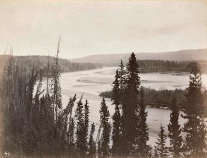
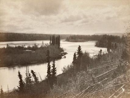
Dawson's survey team camp, dated September 20, 1879, four days before they arrived at Drift-Pile Camp. It gives an impression of what life was like for the Dawson entourage on their travels.
A portion of G.M. Dawson’s 1879-80 map showing the dates and duration he spent at his camps, including Drift-pile Camp inside the red circle.

locating the Drift-pile Camp
Drift-pile Cree Nation is a Treaty 8 First Nation with Reserve lands on the south shore of Lesser Slave Lake and is one of five contemporary First Nations with reserve land bordering the lake. Dawson’s diaries and maps have been used by current members of the Drift-pile Cree Nation to search for and potentially locate the 1879 Drift-pile Camp, which Dawson described and noted its coordinates in his notes.
In 2010 and again in 2020, Drift-pile Elders and staff from the Archaeological Survey of Alberta set out to find Dawson's Drift-Pile Camp. Their search was not conclusive in determining the exact location, but the effort was critical to the understanding the area as a significant cultural landscape in the context of Canada’s search for reconciliation. Drift-Pile Camp has now been afforded protections under the Alberta Historical Resources Act. 5
the maps and the Pendennis Hotel
It is not known who left these maps in the Pendennis Hotel, or how they were intended to be used. They tell an evolving story of the European occupation of western Canada. What they do not contain, from today’s perspective of today's post-Truth and Reconciliation Commission era, is perhaps more telling than what they do contain. The strong cooperative relationship with Indigenous Peoples gradually became less important as the west was colonised and settled. But the treaty maps, such as Treaty 8 territory in which the Drift-pile Camp is located, provide ongoing identification and documentation of historical Indigenous populations in western Canada.
The story of searching for the location of the Drift-Pile Camp brings together the reclaiming of this land by Indigenous Peoples in the twenty-first century with the colonising efforts of the nineteen century, depicted in the early maps. Dawson’s 1879-80 map, as a historic document, has a value that could not have been predicted at the time of its making. p
Drift-Pile Camp, Retroactive, Historic Resources Management Branch of Alberta, Culture and Status of Women. https://albertashistoricplaces.com/2020/08/26/reverting-colonial-cartography-searching-for-drift-pile-camp/
5
David Murray is an architect in Edmonton, Alberta, who specialises in the evaluation, protection and conservation of historic building resources. He has a keen interest in the human stories that are embedded in his projects.
on site review 42: atlas :: being in place 59
Reverting Colonial Cartography: Searching for
Library and Archives Canada
David Murray
Library and Archives Canada
Donald Trump's 20/24 vision sees the world through orange-coloured glasses; bent on serving himself, undermining democracy and laserfocussed on power, money and golf. You can map out where he hopes to see us in the future: deaf, dumb, blind and in his pocket. p
on some maps
stephanie white
What is the project behind any map – the imperial project? the anti-colonial project of the surrealists? the destabilisation project of Trumpism? The exact project is revealed by the relationship of the map to land.
There are times for accuracy, the 1:1 measure, and times for hyperbole, distortion, the polished narrative.
Trumpworld Map was drawn by Kuper from a series of verbal proclamations and performances meant to destabilise power relations – there is no geography, only potential transactions, and it is to T’s advantage to discredit the target before buying it. This is not geography. As shown in Kuper’s map there is a miasma of weakness, poverty, illness and underdevelopment, ripe for the picking.

Classic colonial theory, from Spivak to Said – the very things one fears are projected onto the other to justify annexation; i.e. other races are conniving because you fear being connived. Sexual appetite is exaggerated in the other, rape of women, sodomy, incest, precisely because these things are both suppressed in, and feared by, the coloniser. It is through a failure of imagination that the worst of one’s own culture is projected onto whole societies, cultures, peoples who have no relationship at all to such fevered imagining.
This particular denigration of the other, so close to the coloniser’s dark self is what allows colonisation: You are weak, vice-ridden; We are strong, therefore it is natural that we will take over your underused land.
What were the most egregious qualities that would justify a new American Empire destabilising the global world order? They are T’s personal fears and preoccupations:
meddlers
ingrates
Puerto Ricans
Jews
Arabs
commies
hoaxers
little men
security threats (that’s us)
foes
and the ultimate scatological preoccupation, shitholes
on site review 42: atlas :: being in place 60
p 2018
peter kuper
Peter Kuper
Peter Kuper is a New York City-based cartoonist and illustrator whose work appears all over the map. https://www.peterkuper.com
:: colonial processes
Anon. 'Le Monde au Temps des Surrealistes'. Brussels: Variétés, 1929
le monde au temps des surrealistes
And why, between 2016 and early 2022 when it all got uglier than one could believe possible, did everyone keep saying 'wow, this is, like, surreal'. Surrealists were at least witty. And knew what a map was.

But, but. When André Breton wrote Surrealist manifesto in Paris in 1924, he was part of a fractious group of postwar artists and poets, surrealists all. Breton demanded notice, shocking with such phrases as ‘The simplest surrealist act consists, with revolvers in hand, of descending into the street and shooting at random, as much as possible, into the crowd.‘1
Seeing this enacted over 600 times in the United States in 2022, one might think of Breton as a disruptor, chaos the goal as surrealist actions purposely have no reason or logic. When Louis Aragon protested, Breton added, in 1925, ‘Surrealism is … a cry of the mind turning back on itself, and it is determined to break apart its fetters, even if it must be by material hammers!’2
Almost all the surrealists of early 1920s’ Paris had been conscripted for World War I; Breton worked with the shell-shocked, at the front Paul Éluard wrote 220 letters to families of men who had been killed. In the face of such useless destruction and futile loss of life, the state machinery that had caused such stupidity was to be destroyed, as Breton proposed, by a psychic automatism – ‘dictated by thought, in the absence of any control exercised by reason, exempt from any aesthetic or moral concern.’ 3
Melancholic, tubercular Paul Éluard, surrealist war poet, abruptly left Paris in 1924, circuitously travelling to Indo-China using the 1922 map Les cinq parties du monde: planisphère comprenant toutes les possessions coloniales, chemins de fer, lignes de navigation, principales lines télégraphiqes, câbles. On his return to Paris, he drew the map above, which appeared in a special surrealist issue of Variétés, published in Brussels in 1929.
Conventional maps attempt veracity; Éluard, witnessing the simultaneous wealth and brutality of colonialism, dispenses with scale in favour of distortions that loom large, or very small, in the mind. This is a map of a world blighted by the machinery of possession. The parts that loom large are largely authocthonous, un-colonised, unconsidered. The parts that are so diminished are the hopelessly corrupted capitalist empires, which used their colonised indigenous troops as cannon fodder in the Great War. p
1 Marguerite Bonnet, André Breton, naissance du surréalisme. Paris: Librairie José Corti, 1975
2 B ureaus de Recherches Surréalistes,15, Rue de Grenelle. In Maurice Nadeau, The History of Surrealism, Cambridge: Belknap Press, 1989
3 A ndré Breton. Surrealist manifesto. Paris: Editions du Sagittaire, 1924
on site review 42: atlas :: being in place 61 1929 s white
Stephanie White is the editor of On Site review
slippage
calls for articles
43: temporary architecture
What is the acceptable durée for architecture? Is it found in construction, or form, or program? Is the temporary a material issue, or is it about occupation? Can a rental suite be considered temporary architecture, no matter how long the physical space has existed? The use of space might be temporary, or the construction of the space itself, such as a Oxfam tent, might be designed to be short-lived.
How can we extend the limits of a temporary architecture so that it becomes a fluid, nimble, responsive typology not just a reactive condition to disaster, or crisis; not just a condition of poverty or charity. Can a temporary architecture be intentionally demountable and moveable, rather than thrown up for quick occupation and then bulldozed, as happens at every informal refugee camp, even in our own first-world cities? Well, of course it can, but is this actually happening?
Sometimes a shoddy building stands on into its second century, beyond all reasonable expectations. How does this happen? Is its use, its symbolic function, part of its material persistence? Sometimes a solidly-built building runs out of programmatic functionality and is let go, a ruin before its time.
So, what is the acceptable, or the probable, or the unfair durée for architecture?
Send proposals for this issue any time up to April 30 2023, final submissions will be due July 1 2023
https://onsitereview.ca/callforarts
44: architecture and play
There are several ways to think about play, the most obvious one being the one which children, with great imagination and entertainment, do, learning as they go. Then there is organised play, sports and such, games involving opposing players of great prowess, skill and combativeness. And somewhere in-between is play that involves messing around for the sake of meaningless joy: play for the sake of play.
There is another use of the word play, which is the looseness in a system. Mechanical parts that have some play are not highly machined, or if they once were are now worn, introducing a play between parts. This is very interesting, that play describes this sloppiness, where exactitude is not a factor.
The architecture of play is linked indubitably to Aldo van Eyck’s schools and playgrounds, and from there all the theories of education, learning and play that so dominated the twentieth century. Increasingly, either through psychology, ideology or health and safety regulations, play has become channelled, scheduled – something closer to a machined part in a busy life than poking about a ditch with a stick. for hours. till dinner time.
Somewhere in all of this is the sense that joy is for children, that eventually one puts aside childish things and gets on with some other form of life, usually something more grim, less joyous. Something we see in the tragic children of war who have been forced to put aside childish things almost from birth.
In the practice of architecture do we have works conceived, designed and built with joy throughout the whole process? Where the sense of play is there from the start, an architecture of simple pleasures, of ridiculous time-wasting that is vastly pleasurable? This transcends program and looks squarely at the process of making architecture.
Examples please, from history, from contemporary practice, from buildings you know, playgrounds you loved, or love. What is the relationship between architecture and play?
Send proposals for this issue any time up to August 31 2023, final submissions will be due December 1 2023
https://onsitereview.onsitereview.ca/callforarts
on site review 42: atlas :: being in place 62
cartographies: urban powerpoint
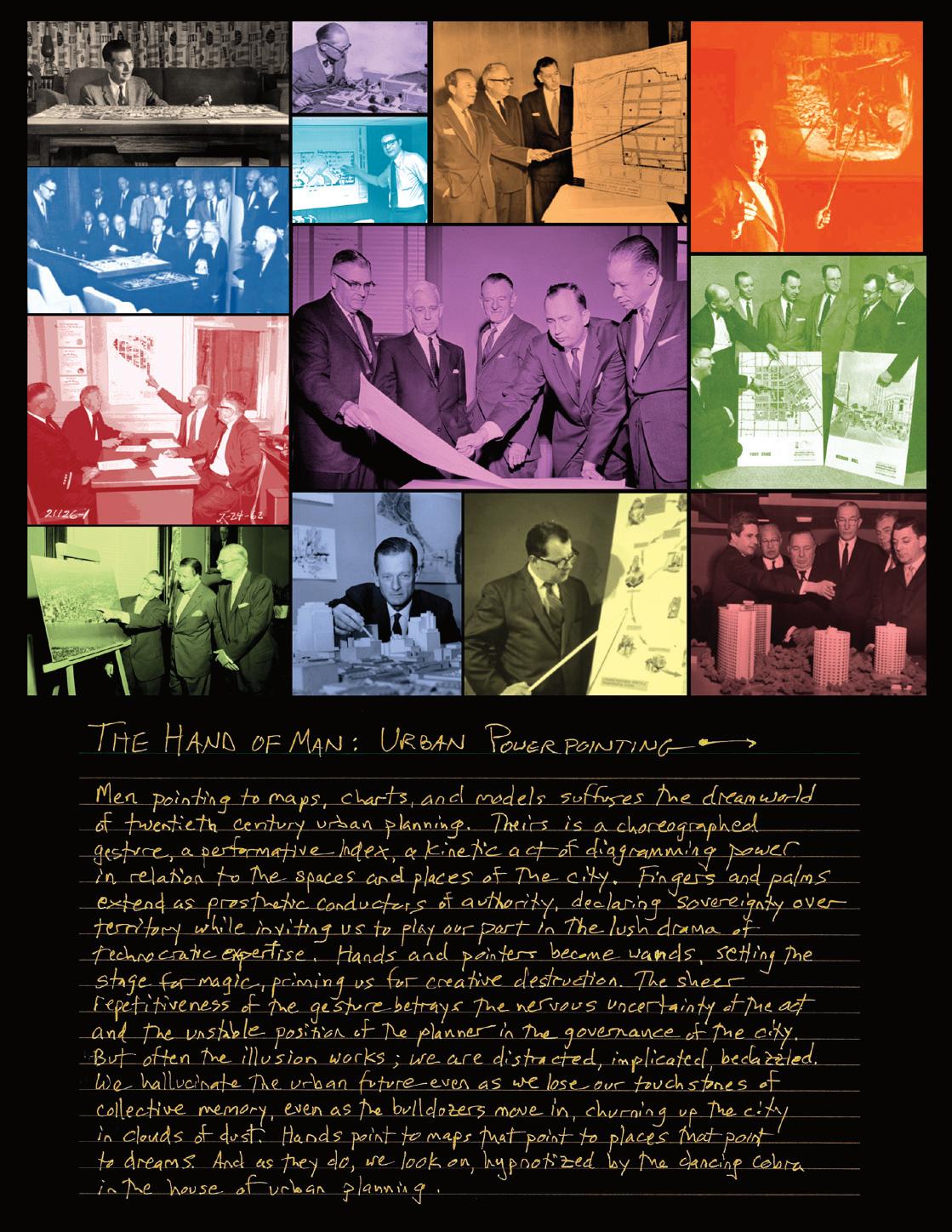
on site review 42: atlas :: being in place 63
joseph heathcott
ON SITE r e v i e w
42 : atlas :: being in place
spring 2023
On Site review is published by Field Notes Press, which promotes field work in matters architectural, cultural and spatial.
On Site review 42: Atlas :: being in place is a collaboration between On Site review, Embassy Cultural House and GardenShip and State – a SSHRC-funded artistic research project. Together we have assembled this project on mapping, decolonisation, migration and belonging.
GardenShip and State, curated by Patrick Mahon and Jeff Thomas, sits at the intersection of environmental critique, de-colonial theory and artistic practice. It has outlined its broad themes: belonging and settler colonialism, migration in times of conflict, inscriptions of land as property, pre-colonial understanding of land, spirit and culture. https://www.gardenship.ca
Embassy Cultural House is an artist-run centre that celebrates the diverse arts and culture community in London, Ontario. It was founded in 1983 by Jamelie Hassan, Ron Benner and jazz musician Eric Stach, and operated until 1990. ECH was re-launched with a digital archive by Tariq Hassan Gordon in 2020 at the height of the pandemic. https://www.embassyculturalhouse.ca
For any and all inquiries, please use the contact form at https://onsitereview.ca/contact-us
Canada Post agreement 40042630
ISSN 1481-8280
copyright: On Site review. All rights reserved. The use of any part of this publication reproduced, transmitted in any form or by any means, electronic, mechanical, photocopied, recorded or otherwise stored in a retrieval system without the prior consent of the publisher is an infringement of Copyright Law Chapter C-30, RSC1988.
back issues:
www.onsitereview.ca
these are listed in the website menu in three groupings: issues 5-16, 17-34 and 35-39
editor: Stephanie White
design:
Black Dog Running
subscriptions: libraries: EBSCO On-Site review #3371594 at www ebsco.com
individual: www onsitereview.ca/subscribe
The forthcoming collaborative programs of Embassy Cultural House and GardenShip and State include a Symposium and Community Gathering at Museum London, March 10 and 11, 2023, at which On Site review 42: Atlas :: being in place will be highlighted in a public presentation.
We acknowledge the funding support for the contributors from GardenShip and State and Embassy Cultural House.

This issue of On Site review was put together in Nanaimo on unceded Coast Salish territory, specifically the traditional territory of the Snuneymuxw Peoples, and in Calgary under Treaty 7 comprised of the Kainai, Siksika, Piikani, Tsuut’ina and Stoney Nakoda First Nations, in place on this land.
on site review 42: atlas :: being in place 64
F I E L D N O T E S
Lize
editors. An atlas of Radical Cartography Los Angeles: the Journal of Aesthetic Protest, 2007-10
https://halfletterpress.com/an-atlas-of-radical-cartography/
2016
https://journals.openedition.org/remi/8803
Peter Jackson, Maps of Meaning London: Unwin Hyman, 1989
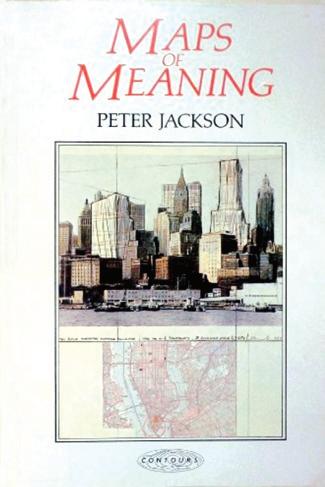
https://www.routledge.com/Maps-of-Meaning/ Jackson/p/book/9780415090889
Dionne Brand, A
to the Door of No Return Toronto: Vintage Canada, 2002
https://www.penguinrandomhouse.ca/ books/17464/a-map-to-the-door-of-no-return-bydionne-brand/9780385258920
& more books
bell hooks, belonging: a culture of place New York, Routledge, 2008
https://bellhooksbooks.com/product/belonging
 Mogel & Alexis Bhagat,
Lucie Bacon, Olivier Clochard, Thomas Honoré, Nicolas Lambert, Sarah Mekdjian et Philippe Rekacewicz, Mapping Migratory Movements.
Map
Mogel & Alexis Bhagat,
Lucie Bacon, Olivier Clochard, Thomas Honoré, Nicolas Lambert, Sarah Mekdjian et Philippe Rekacewicz, Mapping Migratory Movements.
Map
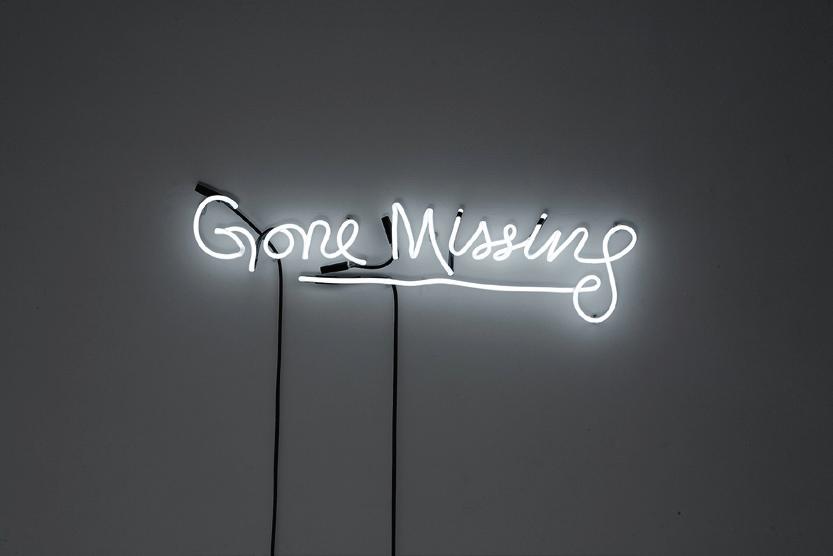
ON SITE r e v i e w 42: 2023 ATLAS :: being in place perhaps belonging but… Yvonne Singer Gone Missing, 2010 neon, one of a series of fragments of a short story www.yvonnesinger.com/gone-missing
Thomas Blanchard