
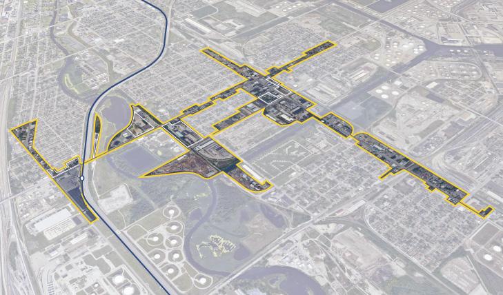
INDIANA INDIANA MICHIGAN ILLINOIS 94 94 80 65 Lake Michigan Hammond Gateway East Chicago Gary Metro Center Miller Portage/ Ogden Dunes 11th Street South Bend Dune Park Beverly Shores Ridge Road Main Street East Chicago 2023 NORTHWEST INDIANA TDD TOD Strategic Implementation Plan
Acknowledgments
This project was completed with Federal Transit Administration TOD Pilot Planning Funds applied for and with a grant match from the Northwest Indiana Regional Development Authority and the Northern Indiana Commuter Transit District.
Throughout this process, the team worked closely with the City of East Chicago to identify and collaboratively advance planning for the community to be proactive about future TOD.
Project Leadership
Northwest Indiana Regional Development Authority


Sherri Ziller, President and CEO
Northern Indiana Commuter Transit District
Michael Noland, President
East Chicago • East Chicago Station i
Northwest Indiana TDD • TOD Strategic Implementation Plan ii Table of Contents 01 02 03 Introduction TOD Strategy Appendix Introduction 1 Transit-Oriented Development 3 Northwest Indiana TOD Strategy 5 Overview 12 Land Use Planning 21 Development Planning 27 Infrastructure 37 Zoning 59 Implementation 64
01
Introduction 01
Overview
The Northwest Indiana Regional Development Authority (Northwest Indiana RDA) and Northern Indiana Commuter Transit District (NICTD) collaborated in 2020 to pursue a Federal Transit Administration Pilot Grant to provide planning assistance to Northwest Indiana communities impacted by the modernization and double tracking of the NICTD South Shore Line and the construction of the NICTD West Lake Line. With support from the State of Indiana and Northwest Indiana cities and towns, the two organizations successfully obtained this grant and, through a competitive RFP process, selected MKSK as the lead planning consultant to prepare this Northwest Indiana Transit-Oriented Development Strategic Implementation Plan. MKSK brought a team of experts to supplement their planning expertise including: Shrewsberry Associates, focused on Civil, Utility, and Transportation Engineering; Metric Environmental, focused on Environmental Conditions and Brownfields; and Town Planning and Urban Design Collaborative (TPUDC), focused on Zoning.
Project Background
Prior to this planning process, the Northwest Indiana RDA was authorized by the Indiana State Legislature to create economic development boundaries, called Transit Development Districts (TDDs), which function similarly to a Tax-Increment Financing District, with the purpose of enabling Transit-Oriented Development (TOD) in Northwest Indiana. TOD in Northwest Indiana will leverage these rail capital investments to provide the opportunity for additional economic development as part of the TDDs established under HEA 1144-2017. As part of this legislation, the RDA is tasked with “incentivizing, guiding and promoting economic development around the stations along the South Shore commuter line and future West Lake Corridor line.” These boundaries are no more than 320 acres (1/2 square mile) in area; capture the incremental growth in local income and property tax revenue for
use in public investment related to the station area; and are calibrated specifically for each community based on analysis, areas of opportunity, and the goals and visions of the community. The first group of eight TDDs was established in September of 2022.
This planning process harnessed the momentum generated by the capital improvements to the NICTD commuter rail system and the creation of TDDs. The team, in close collaboration with the RDA and NICTD, then commenced a process focused on how each community impacted with the rail projects and TDDs can be proactive in attracting economic development in accordance with its own growth path. This planning process commenced in September 2021 and was finalized in March 2023.
The communities along the NICTD South Shore and West Lake Lines are diverse and unique. The history, people, natural environment, and built character of each community differentiates it from another; those qualities create an unmistakable identity. In each city and town, there is a deep pride and a sense of individual spirit. Because of this, it is of the highest importance that the growth of these communities be carefully considered against what makes them special today and what their aspirations may be for tomorrow.
The planning process is built upon a deep knowledge of work and a close collaborative relationship with local cities and towns and the RDA’s long-standing commitment to supporting capital investments and economic development in Northwest Indiana. This process also built upon work completed as part of the West Lake Transit-Oriented Development Plan for Hammond, Munster, and Dyer in 2017, completed by the Northwest Indiana Regional Plan Commission (NIRPC), and recent plans completed by local cities and towns.
2 Northwest Indiana TDD • TOD Strategic Implementation Plan
01 Introduction
Transit-Oriented Development
Transit-Oriented Development Primer
Transit-Oriented Development will look different in each Northwest Indiana community, tied to each community’s individual growth path.
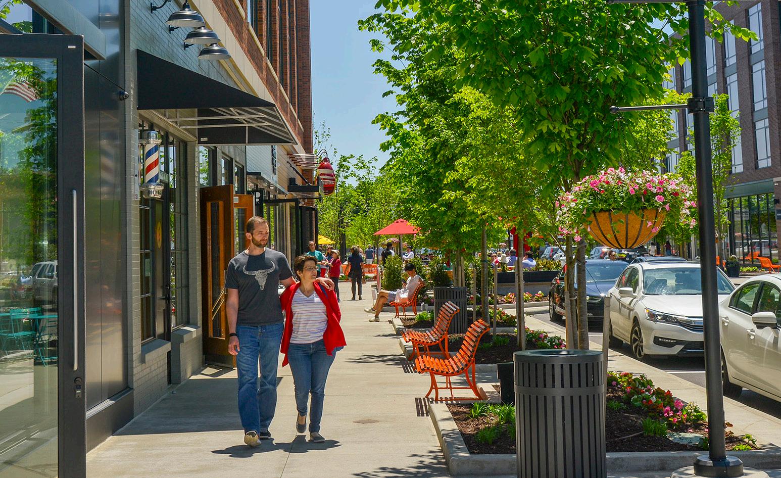
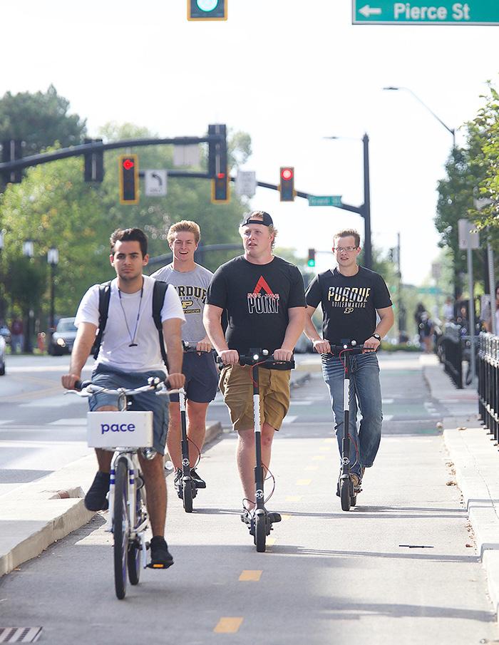
The Federal Transit Administration defines Transit-Oriented Development (TOD) as a dense, walkable, mixed-use area centered around or located near a transit station. This concentration of development fosters a vibrant, connected community because of increased access to jobs, amenities, businesses, and housing. TOD also emphasizes non-motorized infrastructure with less reliance on automobiles, resulting in improved safety, congestion mitigation, environmental resiliency, and better quality of life for all.
Benefits of TOD:
• Provides transportation choices and reduces dependence on driving
• Reduces vehicular travel times, congestion, and emissions
• Encourages more walkable cities and towns
• Reduces land consumption for development
• Reduces parking and increases the opportunity for higher/better uses of land
• Provides residents with choices to live, work, and play in the same area
• Expands equitable access to jobs and housing
• Links urban and suburban areas to people and jobs
• Increases housing choices by including a variety of housing types (such as homes on smaller lots, condominiums, townhomes, apartments, etc.)
• Fosters lively community nodes with co-located mix of uses (including all housing types, retail/ shops, restaurants, office, institutional, and commercial)
• Stimulates the revitalization of economically challenged areas
• Increases the potential for community growth and economic activity, stimulates the local economy
• Results in higher state and local tax revenues from increased development opportunity and activity
• Increases a community’s resiliency through a more dynamic mix of uses that makes it less subject to economic volatility
Equitable Transit-Oriented Development
Furthermore, TOD brings equity to the conversation. Equitable Transit-Oriented Development (ETOD) is an important and emerging lens through which economic, environmental, and social sustainability is at the forefront. ETOD focuses on representing the community in decision-making to realize communityfocused benefits. ETOD has the potential to uplift historically disadvantaged communities by providing tailored planning support. Planning grounded in equity should produce policies and programs that improve transit access to economic and social opportunities such as workforce housing, jobs, education, healthy food, recreation, and healthcare, particularly in underserved areas.
Information through this process will help communities plan proactively for development; attract the private market to invest based on assets and opportunities; and apply for funding through local, state, federal, and philanthropic sources. Cities and towns can easily advance planning recommendations produced as part of this process into adopted plans and ordinances that support community building and economic development pursuant to their growth path.
Why is TOD Important for Northwest Indiana?
The historical investment in the NICTD South Shore and West Lake Lines, paired with the ability for TDDs to catalyze development in Northwest Indiana, will be transformative in the communities along the lines. This is a once-in-a-generation opportunity to build upon the public investments (including the $646 million in the Double Track and $852 million in the West Lake capital improvements) to attract economic development to the region through TOD tethered to the country’s third-largest city, Chicago.
Introduction 3
TOD will boost the economy of Northwest Indiana and offer new, healthier lifestyle choices for residents of the region’s cities and towns. The modernization of the NICTD commuter rail line will allow for enhanced rail competition with vehicular commuters into the Chicago Loop, bringing the rail commute time equal to, if not faster than, vehicular drive times, and much cheaper than driving and parking in Chicago.
The RDA’s Comprehensive Strategic Plan estimates $2.7 billion in projected TOD investments in Northwest Indiana due to these rail projects. Many communities are receiving upgraded stations as part of the rail capital improvements. New stations are being constructed in Hammond, Miller (Gary), Michigan City, and Munster; existing stations are being upgraded in Portage/Ogden Dunes and Dune Park. Due to these improvements, TOD projects are already occurring in Michigan City and Hammond, with others to follow. This type of investment has also been happening in the Chicagoland suburbs for decades.
Orland Park Metra Station - SWS Line (2007)
+17% 1.2M +37%
Square Feet of New Construction
Elmhurst Metra Station - UP-W Line (2006)
+11% 640k +40%
Square Feet of New Construction
Highland Park Metra Station - UP-N Line (2009)
0% 640k +43%
Square Feet of New Construction
Romeoville Metra Station - HC Line (2018) 0% 316k +3%
Square Feet of New Construction
Example metrics illustrating the levels and types of investment and impacts occurring in TOD areas in Chicagoland suburbs.
$2.7 Billion in Projected TOD Investments Due to Rail Projects
4 Northwest Indiana TDD • TOD Strategic Implementation Plan 2022 Billions $0.0 $1.0 $2.0 $3.0 2023 2024 2025 2026 2027 2028 2029 2030 2031 2032 2033 2034 2035 2036 2037 2038 2039 2040 2041 South Bend East Chicago Michigan City Munster Dyer Gary Miller Hammond South Gary Metro Hammond Gateway Portage Ogden Dunes Munster Ridge Road
Population Growth Population Growth Population Growth Population Growth Change in Real Estate Value Change in Real Estate Value Change in Real Estate Value Change in Real Estate Value
Northwest Indiana TOD Strategy
Planning Process
This process commenced by bringing the same level of planning assistance to each community impacted by the NICTD South Shore and West Lake Lines, focusing on communities with a TDD boundary in place or with significant economic development opportunities tied to the station area. To accomplish this, a three-step process planning process was employed. This process began with work sessions with each city or town to understand the level of interest and goals for TOD in each community in alignment with their individual growth path.
Through the previous TDD boundary process, the consultant team understood that various factors, such as local political and staff changes, potential catalytic private development, and ongoing planning or infrastructure projects, would impact project work and schedules on a community-by-community basis. To account for these variables, we employed a schedule that begins with a first step of identifying planning needs for each station area.
Based on planning needs and community readiness, we proposed to group station areas to accommodate varying situations and stagger planning activities.
Generally, each community process took approximately 12 months. All of this work was completed between October 2021 and March 2023. During this time, Northwest Indiana RDA and the consultant team met directly with local staff, stakeholders, elected and appointed officials, and the public to solicit feedback and direction for each TOD-focused plan. As a result, individualized community plans have been developed for each study area with supporting appendix materials from technical sub-consultants.
Step 1
Present Previous Findings, Confirm Direction & Establish Priorities
Timeframe: 6-8 weeks
Step 2
Conduct In-Depth Analysis, Advance Development/ Infrastructure Planning & Evaluate Regulating Resources
Timeframe: varies
Step 3
Conduct Individualized Planning Activities & Provide Recommendations and Documentation
Timeframe: varies
CONCURRENT: Public Engagement, Client, Local Officials & Team Meetings
Planning Process Introduction 5
West Lake Line & South Shore Double Track Projects
West Lake Line Project
9 MILES South Shore Line Double Track Project
25 MILES
16 MILES
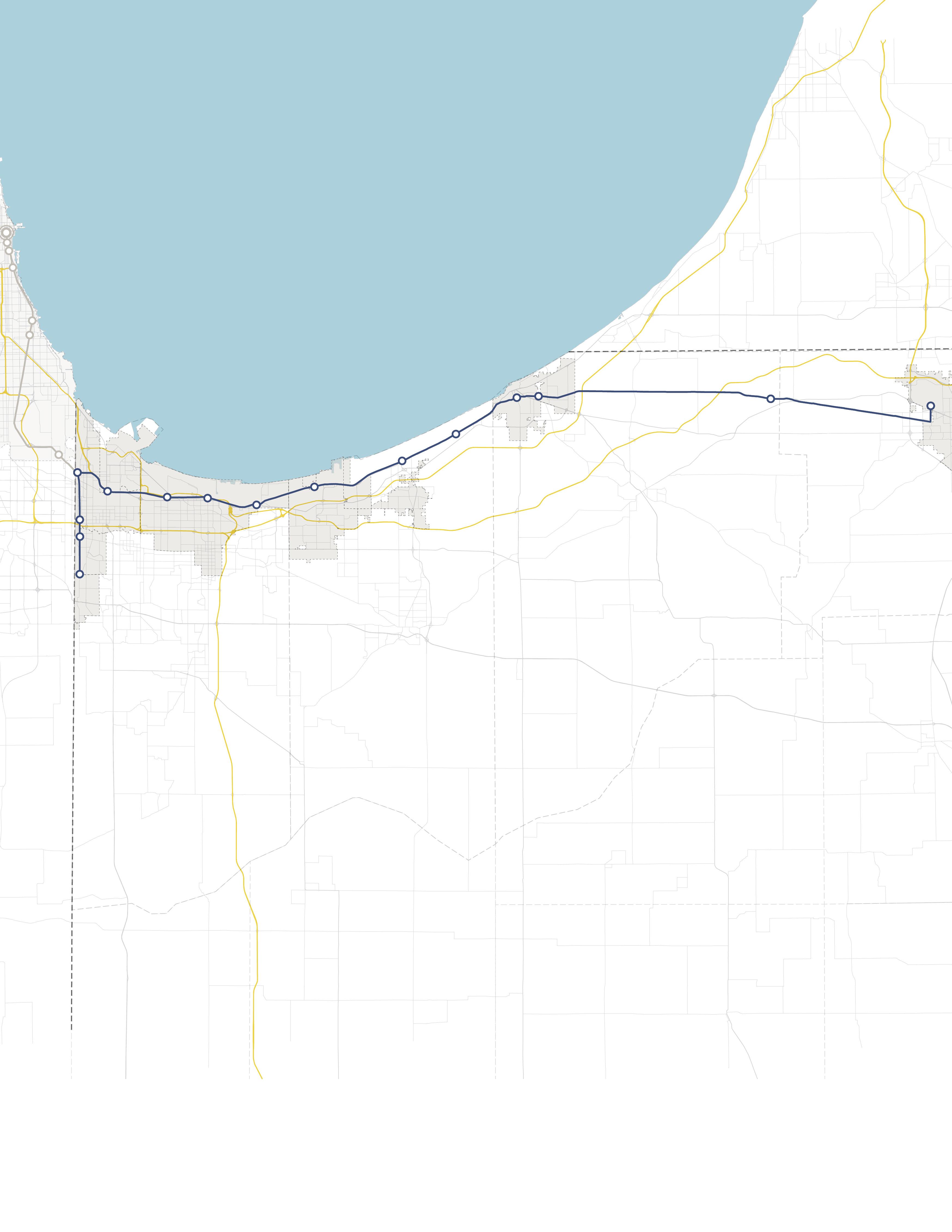
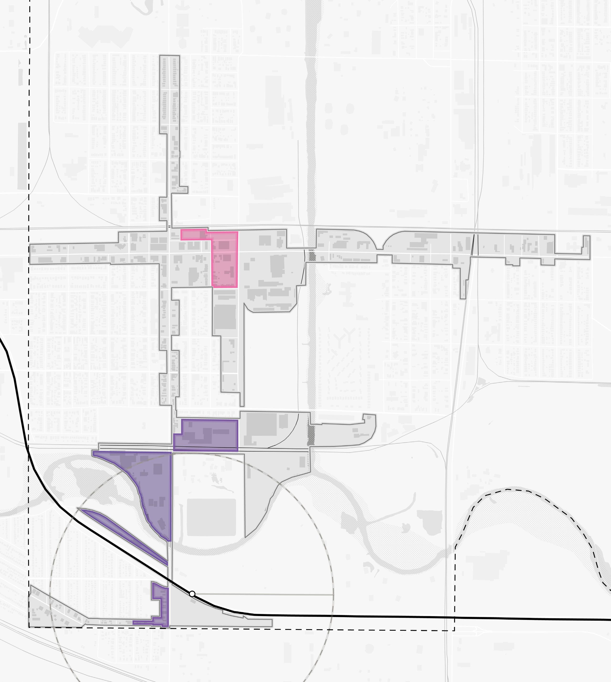
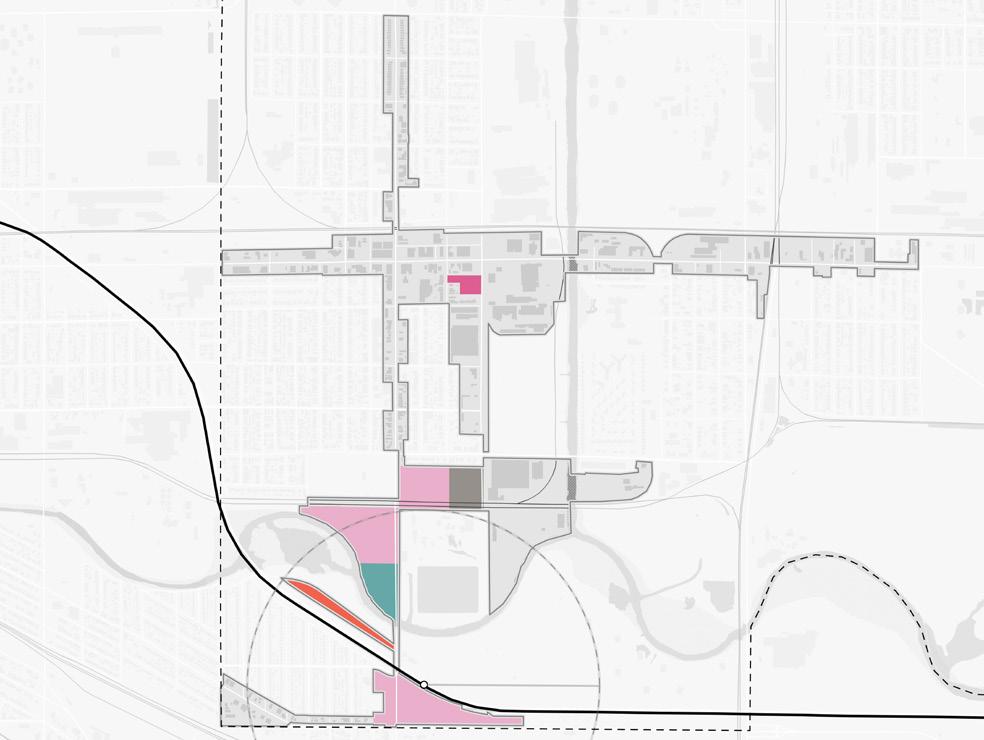
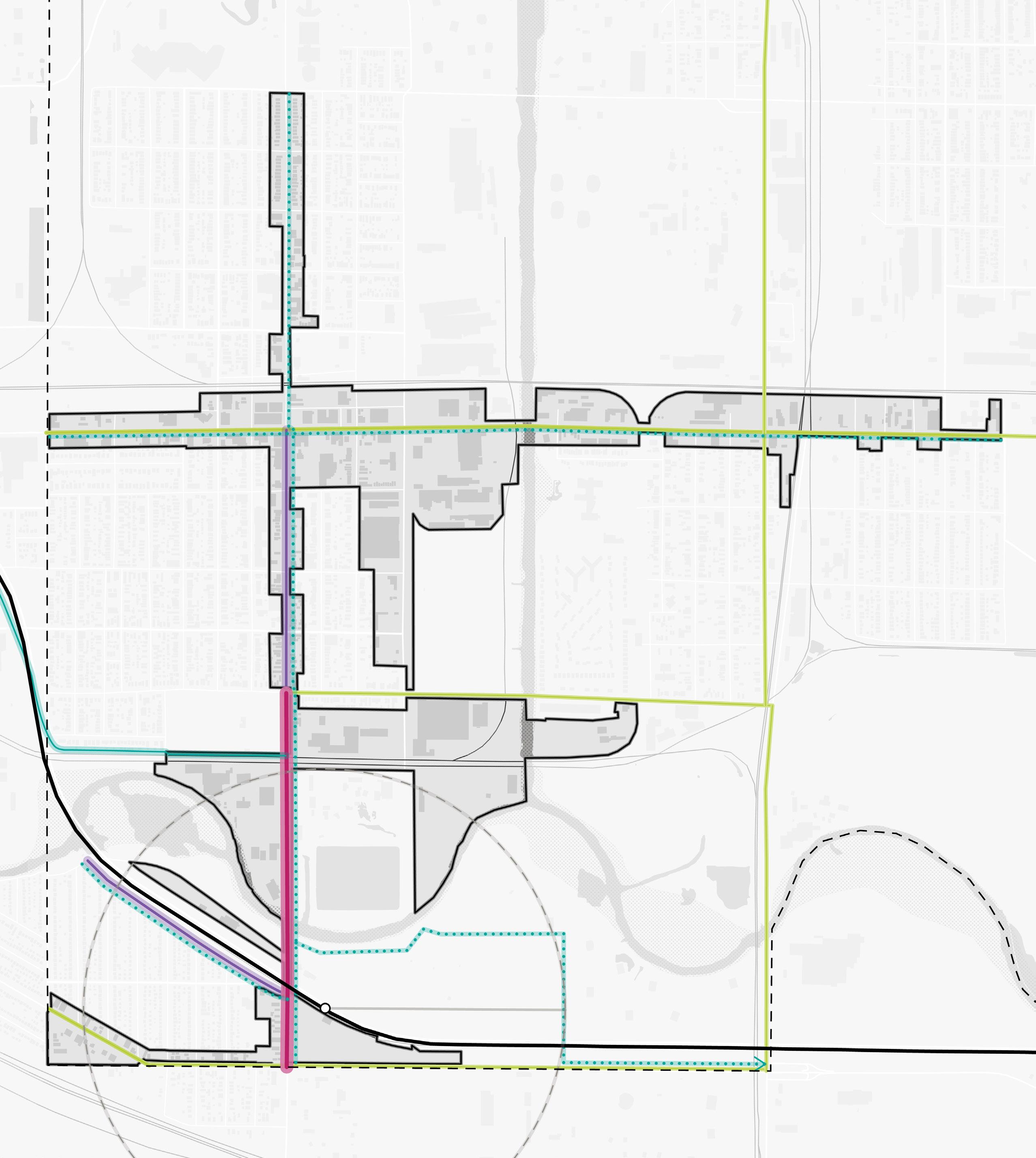
Communities Studied
The project focused primarily on communities with an established TDD boundary or with a TOD study area. However, high-level assessments were also conducted for communities with stations along the South Shore Line who are eligible for future TDD boundaries. Several stations along the lines were not studied at the request of local leadership in consultation with the Northwest Indiana RDA and NICTD.
South Shore Line
• East Chicago (TDD Boundary)
• Metro Center, Gary (TOD Study Area)
• Miller, Gary (TDD Boundary)
• Portage/Ogden Dunes (Two-Community TDD Boundary)
• Dune Park (High-Level Study)
• Beverly Shores (High-Level Study)
• Michigan City (TDD Boundary)
• South Bend (High-Level Study)
West Lake Line
• Hammond Gateway/Downtown, Hammond (TDD Boundary)
• Ridge Road, Munster (TDD Boundary)
• Main Street, Munster & Dyer (Two-Community TDD Boundary)
NORTH INDIANA INDIANA MICHIGAN ILLINOIS 94 94 80 65 Lake Michigan Lake County Porter County LaPorte County St. Joseph County GARY PORTAGE BURNS HARBOR PORTER CHESTERTON MICHIGAN CITY EAST CHICAGO HAMMOND MUNSTER DYER SOUTH BEND Hammond Gateway East Chicago Gary Metro Center Miller Portage/ Ogden Dunes 11th Street South Bend Dune Park Beverly Shores Ridge Road Main Street 6 Northwest Indiana TDD • TOD Strategic Implementation Plan
Rail Extension
Project Area New Second Track
Scope of Work
To further develop an individualized approach for each community, work plans were created, incorporating specific information desired by the FTA to be included in the planning process and other planning processes at the request of the communities, if any. The Scope of Work Breakdown on the following pages detail the work plan and planning activities in this process.
The following task list organized the work plans:
• Individualized engagement approach
• TOD readiness evaluation
• Previous planning gaps and opportunities
• TOD types and community priorities
• Potential areas of impact (TOD areas and other areas of anticipated significant change)
• Future land use projections (5-, 10- , 20-year time horizons)
• Development feasibility testing and potential community impacts
• Development character renderings
• Thoroughfare typology assignments
• Conceptual corridor designs
• Brownfield assessments
• Infrastructure assessments
• Zoning code/ordinance analysis and recommendations
• Order of magnitude infrastructure and corridor cost estimates
• Additional tasks as requested by individual communities, which may consist of corridor/ connectivity planning, neighborhood/subarea planning, additional engagement activities, additional site concept designs and/or renderings, development pitch kits, open space and trail planning, case study research, additional conceptual street design, capacity building, action planning, and one-year follow-up summaries
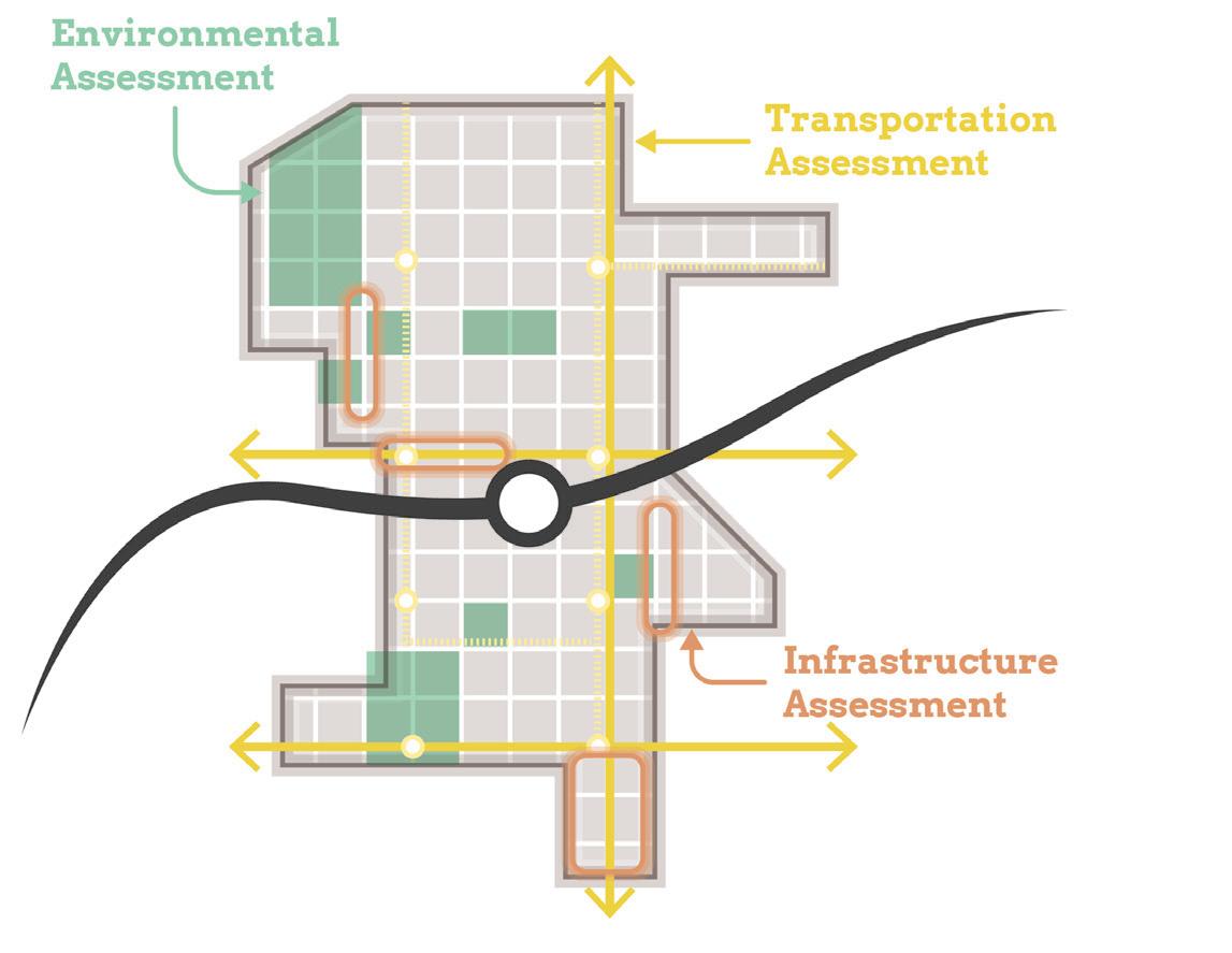
Scope Items
Planning Needs and Gaps Analysis
Land Use & Zoning Review and Recommendations
Environmental Assessment and Recommendations
Transportation Assessment and Recommendations
Infrastructure Assessment and Recommendations
Development Testing
Capital Improvements Plan
On-Going Efforts
Coordination with NICTD
Stakeholder and Public Engagement
Introduction 7
Planning Needs and Gaps Analysis
• Confirm framework plan direction by correlating objectives from previously completed plans with the community’s current future vision
• Identify gaps and opportunities not addressed in local planning based on previously completed plans
• Determine and prioritize planning needs for future development and recommendations
Land Use & Zoning Review and Recommendations
• Record and analyze current land use and zoning ordinances
• Identify potential changes in land use and zoning ordinances to achieve desired future development
• Coordinate zoning with planning concepts and planned land uses
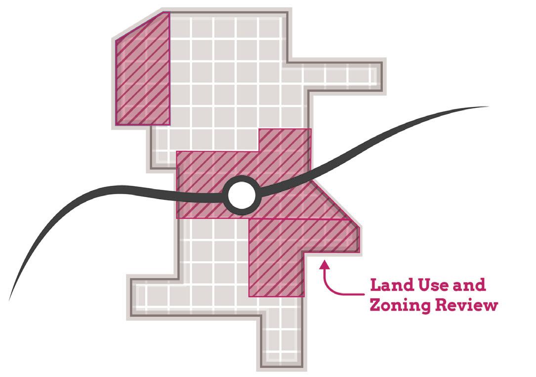
• Draft zoning code revisions and/or design guidelines to promote future TOD
• Draft regulating plan/zoning map
• RDA consultants will take zoning through process for adoption by local entities
Environmental Assessment and Recommendations
• Limited assessment of sites with potential or known environmental/brownfield concerns
Transportation Assessment and Recommendations
• Corridor and connectivity planning that improves access and walkability to the station area
Infrastructure Assessment and Recommendations
• Evaluating stormwater, utility, road, and pedestrian facilities at site and district scales
Scope of Work Breakdown
8 Northwest Indiana TDD • TOD Strategic Implementation Plan
Development Testing
• Identify up to eight priority development sites per station area (each “site” up to 10 acres)
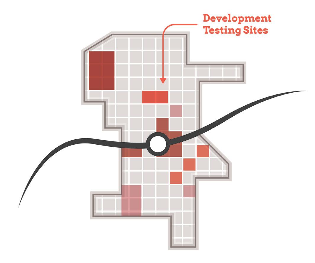
• Test development scenarios for priority sites
• Assess potential site uses based on land use projections and market understanding
• Develop conceptual site plans and three dimensional massing illustrations showing potential infill and redevelopment
Capital Improvements Plan
• Order of magnitude cost estimates for infrastructure improvements and projects to effectuate development (with close collaboration with local units)
Scope of Work Breakdown
Introduction 9
TOD Readiness
At the onset of the process, the team acknowledged that each community differed in its potential for TOD as a result of existing policies and infrastructure in place that are necessary to enable TOD, referred to as TOD readiness. To diagnose each community’s TOD readiness, a matrix was developed to evaluate factors of TOD readiness and was completed in collaboration with local officials. In addition, NICTD completed TOD assessments, which were consulted as these evaluations were completed.
TOD Readiness Criteria
• NICTD Station currently operational or under construction
• TDD Boundary is adopted or the community is eligible for a TDD Boundary
• Adopted policy documents that address or plan for TOD (i.e. comprehensive plan, neighborhood plan)
• Adopted zoning ordinances (or overlays) that address or plan for TOD
• Existing walkable grid as part of a downtown or mixed-use neighborhood that connects or can connect to the station
• Currently operational/planned trail or multi-modal infrastructure
• Existing urban amenities that are walkable and/ or within 1/2 mile of the station (i.e. restaurants, grocery, drug stores, office, parks/plazas)
• Existing dense and quality housing stock (more than eight dwelling units/acre), including rowhouses/townhomes, apartments, condos, and ADUs
• Vacant developable sites within TDD Boundary
• Local unit has demonstrated additional initiatives to support TOD
• Current infrastructure has the capacity to support additional development or TOD
Anticipated Results
At the conclusion of this process, control of local land use and zoning remains with the cities and towns. This process aims to provide proactive guidance and recommendations that the local units can use to advance their planning processes, resulting in updated comprehensive plans, area plans, and zoning ordinances complete with locally-controlled public input. In addition, components of this study are designed in a highly-graphic format to inform development discussions, potential RFP’s, and grant applications. The following sections reflect recommendations particular to each TOD study area with key considerations, immediate next steps (next year), short-term recommendations (next five years), and long-term recommendations (beyond five years).
Each community-specific section will function as a standalone plan that is meant to be pulled out of the overall regional plan and referenced by officials of local cities and towns, public members, and the development community. This information is supplemented by more technical information in the respective appendices.
10 Northwest Indiana TDD • TOD Strategic Implementation Plan
02 TOD Strategy 02
East Chicago East Chicago
Overview
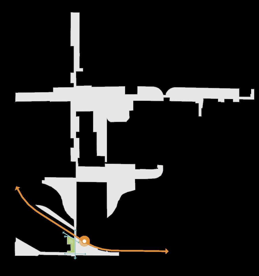
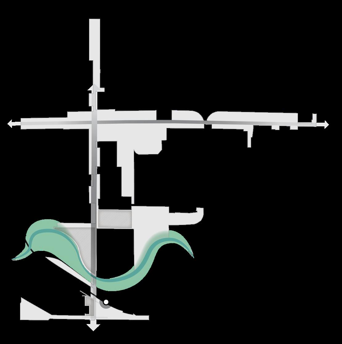
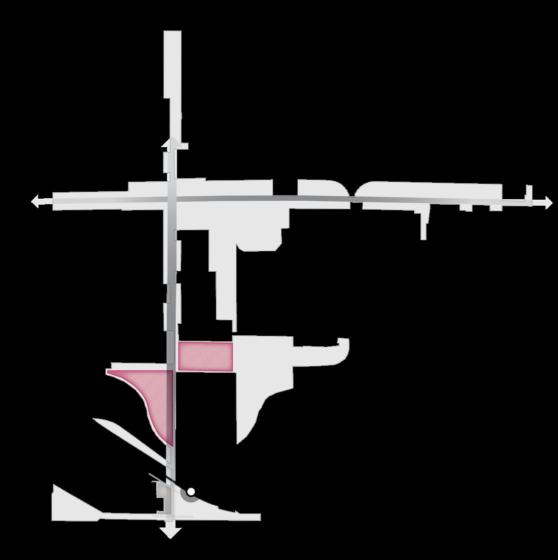
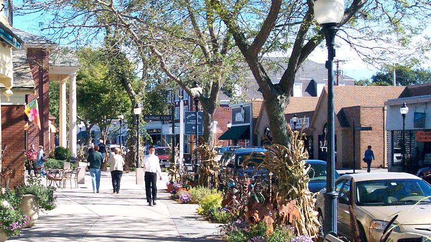
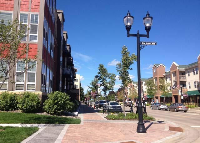
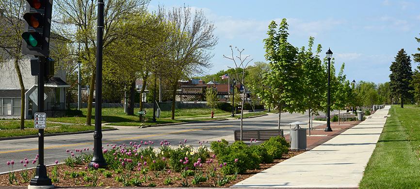
The East Chicago Station has the highest number of park-and-ride commuters along the Northern Indiana Commuter Transportation District (NICTD) South Shore Line. While this station is already double-tracked and is not seeing capital improvements as part of the NICTD modernization effort, it will benefit from improved commute times (50 minutes) to Downtown Chicago. This location will likely remain a significant commuter/park-and-ride site for the foreseeable future due to its location, surrounded by the I-90/Indiana Toll Road, industrial and utility land uses, and the established Roxana Neighborhood. The transit-oriented development (TOD) opportunities in East Chicago are located on the south side of East Chicago along Indianapolis Boulevard.
This TOD area aims to build upon the vibrancy of the Roxana Neighborhood’s presence as a naturally-occurring TOD and expand potential development along Indianapolis Boulevard. A key tenet of the TOD strategy is to create a better gateway to the station area along Indianapolis Boulevard (also US 20, under INDOT jurisdiction) by first focusing on a Complete Streets strategy for the corridor with high-quality connections to the funded and partially constructed Marquette Greenway (½ mile from the station) with trail-oriented development along north of I-90. This section focuses on materials and recommendations that will prepare the City of East Chicago to update its plans and ordinances, open up conversations between the City and INDOT to improve Indianapolis Boulevard, and advance its pursuit of TOD as a community gateway for the modernized NICTD South Shore Line.
02 Northwest Indiana TDD • TOD Strategic Implementation Plan 12
TOD Readiness
The City of East Chicago has supported TOD at the East Chicago Station and the nearby Roxana Neighborhood by engaging in a TOD plan for the Roxana Neighborhood in 2016. The City has been actively supporting the extension of the Marquette Greenway to the East Chicago Station to better support connectivity from neighborhoods to the station. The City also supports Complete Streets improvements on Indianapolis Boulevard/US 20. The City understands that the positioning of the station surrounded by rail, highways, and industry is not optimal for TOD; however scaling TOD appropriately along Indianapolis Boulevard and providing meaningful pedestrian linkages to the north can increase the development’s impact along this corridor to include more diverse housing options.
There is also an opportunity with the Grand Calumet River and Roxana Marsh that can provide greenspace amenities for residents in the area if properly connected via trails.
This document serves as a roadmap for TOD implementation by providing recommendations for land use, development, zoning, and infrastructure investments.
Evaluation Criteria
NICTD Station currently operational or under construction
TDD Boundary is adopted or the community is eligible for a TDD Boundary
Adopted zoning ordinances (or overlays) that address or plan for TOD
Adopted policy documents that address or plan for TOD (i.e. comprehensive plan, neighborhood plan)
Existing walkable grid as part of a downtown or mixed-use neighborhood that connects or can connect to the station
Currently operational/planned trail or multi-modal infrastructure
Existing urban amenities that are walkable/within 1/2 mile of the station (i.e. restaurants, grocery, drug stores, office, parks/plazas)
Existing dense and quality housing stock (more than 8 dwelling units/acre), including rowhouses/ townhomes, apartments, condos, and ADUs
Vacant developable sites within TDD Boundary
Local unit has demonstrated additional initiatives to support TOD
Current infrastructure has the capacity to support TOD/additional development
East Chicago • East Chicago Station 13
Community Priorities
Community priorities were developed by working closely with City officials to confirm economic development goals, identify key sites of interest, and understand recent and ongoing municipal and development projects. These priorities form a future vision for the TDD boundary area specific to East Chicago, which include the following:
• Clean up and restoration of the Grand Calumet River to transform the river corridor and Roxana Marsh into an environmental and recreational amenity
• Mixed-use transit-oriented development around the station area
• Enhancing connectivity to the station and between neighborhoods and creating a gateway into the community
• Public and private investments of major corridors: Chicago Avenue, Indianapolis Boulevard, and Carrol Street/Michigan Street in collaboration with INDOT and the City of Hammond
• Establish a variety of housing options through TOD, reinvestment, and infill development, including mixed-income housing
Big Moves
“Big Moves” are defined as enabling steps to signal to the market that conditions are right for transit-oriented development to occur. Opportunities around the East Chicago Station consist of a mix of uses at low- to medium-densities within the Roxana Neighborhood west of the station. North of the Grand Calumet River, several industrial sites have the potential for redevelopment to support high-quality, dense housing. Streetscape and traffic improvements along Indianapolis Boulevard can enhance connectivity and walkability to the station from neighborhoods north of the river. Improvements in the Roxana Neighborhood should focus on strengthening commercial opportunities along Indianapolis Boulevard and creating safe connections to the station across Indianapolis Boulevard. Continued cleanup of the Grand Calumet River has the potential to transform the riverfront into a tremendous community asset.
Northwest Indiana TDD • TOD Strategic Implementation Plan 14
Station Area TOD Corridor Improvements
This area has the potential to attract economic development by investing in Indianapolis Boulevard as a vital gateway into the community. The frontage on the west side of Indianapolis Boulevard between Michigan and Carrol Streets and the South Shore Line could redevelop as TOD to support station activity and enhance the adjacent Roxana Neighborhood. Ensuring safe connections to the station from existing neighborhoods is crucial to activating this area.
Indianapolis Boulevard, particularly the segment south of 151st Street, would benefit greatly from design enhancements to increase walkability, connect to the Marquette Greenway, improve traffic flow, and increase safety for all. Chicago Avenue is also an important commercial corridor that would benefit from infrastructure investments. The intersection of Indianapolis Boulevard and Carrol Street/Michigan Street is also in need of improvements in collaboration with both East Chicago and Hammond.
South Shore Line South Shore Line Indianapolis Blvd Chicago Ave 151st St Carrol St Indianapolis Blvd Chicago Ave 151st St Carrol St
East Chicago • East Chicago Station 15
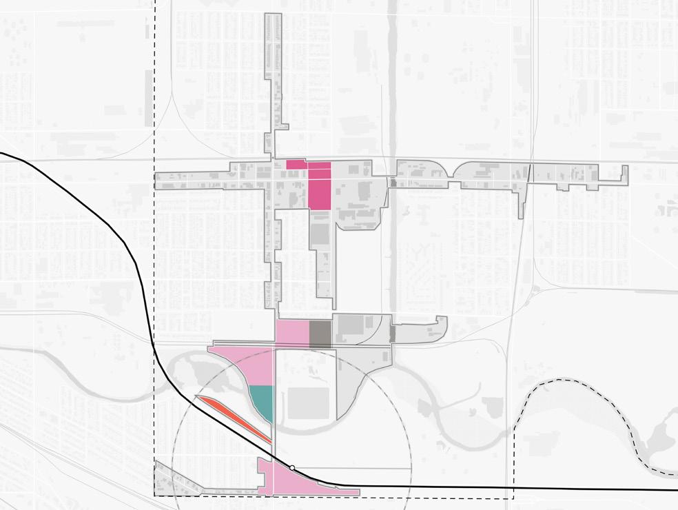
NORTH Big Moves
Industrial Repositioning
Industrial sites north of the Grand Calumet River have potential to be rethought as residential neighborhoods with a mix of housing types. Commercial and employment uses as well as green space should act as buffers from nearby industrial uses.
Re-Envision the River
Cleanup efforts are already underway for the Grand Calumet River in East Chicago, and there lies a special opportunity in the Roxana Marsh to activate the river corridor as a natural community amenity. The riverfront and marsh can provide park space and be linked via trails to the rest of the community and the Marquette Greenway.
South Shore Line South Shore Line Indianapolis Blvd Chicago Ave 151st St Carrol St Indianapolis Blvd Chicago Ave 151st St Carrol St
Northwest Indiana TDD • TOD Strategic Implementation Plan 16
NORTH Big Moves
TOD Opportunity
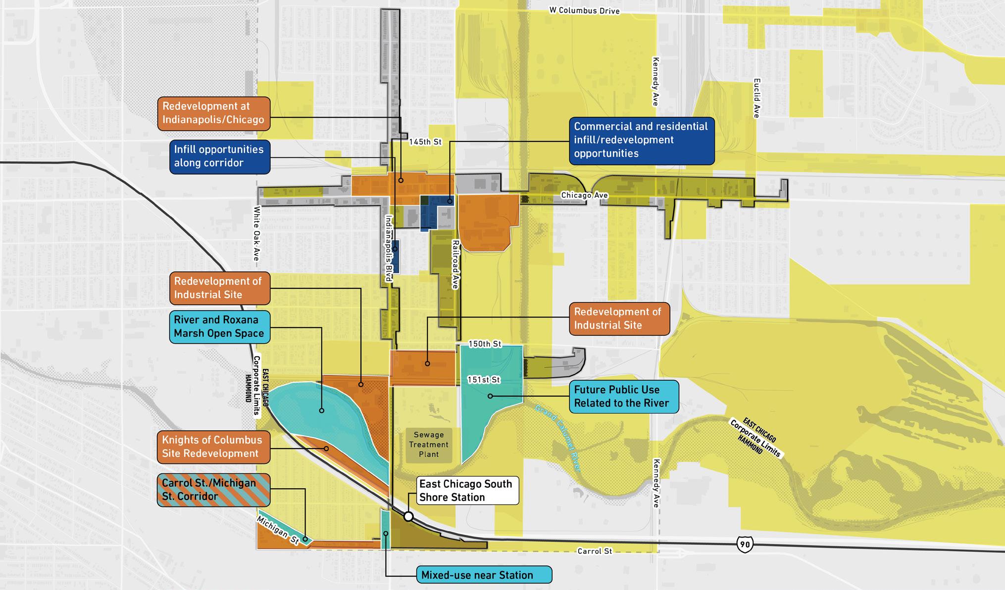
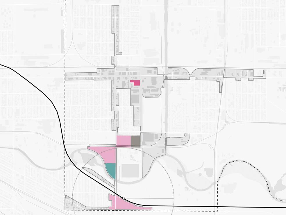
An overall TOD Opportunity vision was developed with the City of East Chicago outlining the development and investment potential within the TDD boundary area. Opportunity sites were identified as Areas of Impact within each TDD boundary that have the greatest development potential. Characteristics such as cleared sites, underutilized land or surface parking lots, buildings suitable for adaptive reuse, or consolidated or municipal land ownership were important factors determining certain sites’ development potential.
Future development aims to create walkable linkages to the East Chicago Station with denser, community-focused mixed-use development that complements the vibrant Roxana Neighborhood and connects to the Marquette Greenway and Kosciuszko Park. The development directly adjacent to the station is envisioned as small-scale mixed-use that is complementary to residential uses, providing commercial uses such as restaurants, childcare, and community services on the ground floor along Indianapolis Boulevard. Further north along Indianapolis Boulevard, industrial uses outside the 100-year floodplain along the Grand Calumet River could transition to residential uses backing up to park and trail frontage. This opportunity leverages both transit-oriented development and trail-oriented development potential.
Areas of Impact
Areas of Impact were established to distinguish between major (re)development areas, both TOD and non-TOD, and areas to be maintained, preserved, and enhanced. These designations begin to direct development activity and other targeted investments based on proximity and relationship to the station area.
For purposes of this study, individual sites may have been grouped to demonstrate synergy among sites for development potential.
TOD Opportunity Sites
These areas are prime sites for transit-oriented development due to their proximity and connectivity to the station area. Development of these sites should be dense and urban in form, promote walkability and multi-modal access, and emphasize a quality public realm and sense of place. Access to the station area is crucial in these areas. Development
should be mixed-use, integrating a variety of active ground-floor commercial uses and upper-floor uses within a building and integrating a variety of uses in a collection of buildings on a site.
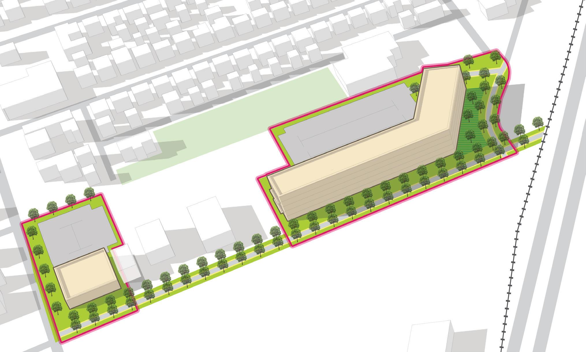
Site A
Site A is the closest development opportunity to the station, directly across Indianapolis Boulevard, in the Roxana Neighborhood. This site is 5.4 acres with primary frontage and high visibility along Indianapolis Boulevard and additional frontage at the Michigan Street and Carrol Street intersection. Existing structures on this site include single-family housing, a restaurant, a gas station, an auto repair business and the East Chicago Public Library. Challenges of this site include ownership and safety concerns of Indianapolis Boulevard for both vehicular traffic circulation and pedestrians, especially regarding access to the station. The development opportunities on this site could benefit from, and therefore should be complementary to, Roxana Park, which has recently been improved. There is also opportunity for future development to incorporate the public library into a new mixed-use building. In addition, redevelopment here would have a significant impact on the character and activity of the station area and serve as a gateway into East Chicago.
Site B
This site is a 29.7-acre primarily industrial site, including warehouse structures and vacant land, with significant frontage along Indianapolis Boulevard. Site B is isolated from the station area by the elevated South Shore Line and I-90/Indiana Toll Road, Roxana Marsh, and the Grand Calumet River; yet this site is walkable to the station and highly accessible via Indianapolis Boulevard and North Roxana Drive. Portions of this site in the floodplain are limited in terms of development, but these areas could be designated as open space or parking areas. Despite these factors, Site B could still support transit-oriented development with upgrades to Indianapolis Boulevard that enhance safety and walkability. This site is adjacent to major natural and recreation amenities of East Chicago: Kosciuszko Park and the Marquette Greenway to the north and the Grand Calumet River and Roxana Marsh in between the two developable portions of the site. Once the cleanup of the river and the proposed extension of the Marquette Greenway is completed, this site’s location will be even more advantageous and attractive.
East Chicago • East Chicago Station 17
Areas of Impact
Several sites along the west side of Indianapolis Boulevard near the East Chicago Station have the potential to be redeveloped into walkable TOD complementary to the existing Roxana Neighborhood and Roxana Park. Additional sites are situated along the existing and proposed Marquette Greenway alignment, which would become an attractive amenity for residents and visitors. To the north, Chicago Avenue presents an opportunity to redevelop a former senior housing site and activate a key intersection to bring more life to the Chicago Avenue corridor.
Site E 10.7 Total Acres E Site C 17.4 Total Acres Site B 29.7 Total Acres Site A 5.3 Total Acres B B A C City Hall and Veterans Park SouthShoreLine EAST CHICAGO HAMMOND Corporate Limits TOD Opportunity Site Area of Significant Change NORTH Northwest Indiana TDD • TOD Strategic Implementation Plan 18 90 East Chicago Station Kennedy Ave Euclid Ave 145th St 148th St Kennedy Ave Carrol St Kosciuszko Park
Riley Park Roxana Marsh Roxana Park and Recreation Center 1/2 Mile EAST CHICAGO HAMMOND Corporate Limits GrandCalumet River 151st St 150th St W Columbus Dr White Oak Ave Railroad Ave Indianapolis Blvd Chicago Ave
Marino/
WARE Manufacturing Facility
Site C
Site C is an industrial site, which is 17.4 acres, consisting of one vacant site, an industrial building and an outdoor storage yard. The site has minimal frontage and access from Indianapolis Boulevard, but the site can also be accessed via Railroad Avenue to the west or 151st Street. Because the site is to the rear of residential properties on two sides, future development should be sensitive to existing housing in both use and scale.
Areas of Significant Change (Non-TOD)
These areas have been identified for their potential for redevelopment and a major change in use and/ or form. These areas are outside the walkable area surrounding the station – therefore not TOD – but high-quality development of these sites is possible and will significantly impact the community. These areas may be identified for several reasons: they have been included in development planning in this plan but are not proximate to the station; they may have development planning efforts ongoing outside of this plan; or there may be a high potential for future development in the long term that has not been studied yet. Development of these sites may require changes in land use, updates to zoning designation and/or regulations, infrastructure upgrades, or environmental review.
Site E
Site E totals 10.3 acres and includes developable areas on either side of Chicago Avenue between Railroad Avenue and Tod Avenue. A large portion of this site is vacant land, in addition to the senior housing building that is slated to be demolished. Other existing structures on this site include single-family housing, a Salvation Army facility, some small commercial buildings, and an auto repair shop This site is highly connected to the street grid and can be accessed from Chicago Avenue, Railroad Avenue, Tod Avenue, Exchange Avenue, Short Street, and existing internal alleyways. Because of its frontage along Chicago Avenue, future development of this site has the potential to reactivate the commercial corridor and provide a gateway in the community after crossing the canal.
Areas to Maintain and Invest
All other areas within the TDD boundary not identified for future development investment opportunities should be targeted for enhancement and preservation efforts that protect the existing character and build upon the strengths or existing assets. These areas may look like stable and established neighborhoods or active commercial nodes. Opportunities for small infill development or rehabilitation of structures may be present in these areas but should occur with a focus on compatibility with the surrounding context and land uses.
TOD Types
Transit-Oriented Development (TOD) Types are not prescriptive of future land use or zoning but instead describe the vision for creating a vibrant, ecosystem with walkability, transit access, and a diverse range of businesses, destinations, and housing. These descriptions have an overarching intent statement and describe typical uses and goals for how development or redevelopment could occur in each of these areas. Short statements are paired with character imagery from other similar places to help visualize these places.
Future TOD in East Chicago is envisioned as Transitional TOD. The following description explains the key considerations of this TOD Type.
East Chicago • East Chicago Station 19
Transitional TOD
Walkable development that transitions between multiple densities and provides a range of commercial, housing types, and services integrated vertically or horizontally
TOD Types
Typical Land Uses
Multi-Family Housing; Attached Housing; Detached Housing; Cultural/Civic; Religious, Education, and Assembly Facilities; Retail/Offices/Services; Medical Offices/Services; Government/Public Facilities; Hospitality; Entertainment; Mixed-Use (vertically and horizontally integrated)
Secondary Land Uses
Supportive Housing; Pocket Parks/Plazas; Greenways/Trails; Recreation Facilities; Floodplain/ Floodway; Preservation/Conservation Area; Surface and Structured Parking; Artisan Manufacturing/Food Production; Office/Flex/Light Industrial
Parking
On-street parking; off-street parking with shared public or private parking lots; bike parking
Transportation
Typical Building Heights/ Density
Interconnected street grid with sidewalks, some bike facilities, and connections to bus/transit
Medium to low density expected to be less than 15 dwelling units per acre; anticipated average height of 2+ stories
Infill/ Redevelopment
Infill should continue the existing visual pattern, rhythm or orientation of surrounding context, when possible. Historically significant or contributing buildings should preserved or adaptively reused when possible. Infill should be of a scale that appropriately visually transitions between two areas.
Other Considerations
Any redevelopment should occur in a sustainable manner that minimizes impacts on natural areas, incorporates proper stormwater management, and mitigates any potential hazards to air or water quality
Northwest Indiana TDD
Land Use Planning
Documentation and Analysis
Previous Planning
Relevant recommendations from the 2016 Roxana TOD Plan, the 2014 Vision for East Chicago, and the 2008 Comprehensive Plan were documented and incorporated into the recommendations for this process.
Gaps & Opportunities
A review of previous land use planning from relevant completed plans for each community was conducted to understand where common themes lie across years of land planning and where ideas of land use have evolved over time or may conflict with each other. The review resulted in identifying opportunities that were consistent across many plans and in line with current community goals. Gaps were identified as areas within the TDD boundaries that have not been studied in great detail in the past but may have future development potential and should be considered to be studied. Gaps and Opportunities were reviewed by each community to determine which land planning thoughts should be carried forward into this land use planning process.
Land use planning in East Chicago has placed importance on the riverfront, industrial properties, and the South Shore Station area. The riverfront has been envisioned with recreation and river access, education, and environmental amenities. Several industrial sites have been identified for redevelopment into other uses; however, future uses for these sites have differed across multiple plans. The Knights of Columbus site has been included in some past plans with various ideas of reuse. Mixed-use transit-oriented development and connectivity have been considered around the South Shore Station area. Improvements to the Indianapolis Boulevard corridor have been planned through both public and private investment. Some infill sites along the Chicago Avenue and Indianapolis Boulevard corridors may present additional opportunities for commercial or mixed-use redevelopment if studied.
Gaps and Opportunities Analysis of previous plans affecting the TDD boundary
Sites Studied
Areas with Similar Future Uses in 2+ Plans
Areas with Varied Future Uses in 2+ Plans
Opportunity Sites Not Previously Studied in Detail
East Chicago • East Chicago Station 21 NORTH
Northwest Indiana TDD • TOD Strategic Implementation Plan 22 NORTH Existing Land Use Single-family Residential Multi-Family Residential Commercial Public Utility and ROW Park District Industrial Vacant Residential Vacant Commercial Vacant Industrial 90 South Shore Line East Chicago Station Kennedy Ave Euclid Ave 145th St 148th St Kennedy Ave Carrol St Kosciuszko
City Hall and Veterans Park Marino/
Riley
Roxana
Roxana Park and Recreation Center 1/2 Mile EAST CHICAGO HAMMOND Corporate Limits EAST CHICAGO HAMMOND Corporate Limits GrandCalumet River 151st St 150th St W Columbus Dr White Oak Ave Railroad Ave Indianapolis Blvd Chicago Ave
Park
WARE Manufacturing Facility
Park
Marsh
Roxana TOD Plan (2016)
The 2016 Roxana TOD Plan was completed by the City of East Chicago to promote urban revitalization through the development and expansion of transit connections to the NICTD Station, buses, and trails throughout the city. This process included recommendations for land use, revitalization, placemaking, and quality of life.
Relevant recommendations include:
• Improve Indianapolis Boulevard physically through Complete Streets and landscape improvements connecting to the Marquette Greenway and creating an environment for economic development
• Manage land uses to emphasize transitioning industrial property along Indianapolis Boulevard between the Marquette Greenway and the station to mixed-use and residential development
• Begin to assemble property outside of the 100-year floodplain along the Grand Calumet River and Roxana Marsh
• Prioritize areas around the South Shore Station for redevelopment with community-oriented and commuter-serving retail, non-profits, and housing
• Collaborate with INDOT to improve the intersection of Carrol Street and Michigan Street at Indianapolis Boulevard
• Build a vibrant entry gateway along Indianapolis Boulevard at the NICTD bridge
• Embrace the Grand Calumet River and Roxana Marsh as park amenities and invest in trail connections/moments in these spaces
• Reinforce East Chicago Transit Center through reinvestment and residential infill
• Establish Revitalization Area to allow the construction of mixed-income housing
• Preserve industrial uses and increase the availability of reuse-ready structures and shovel-ready sites
• Design blocks around Kosciusko Park to complement park/park activities
• Adopt TOD Overlay Zoning District
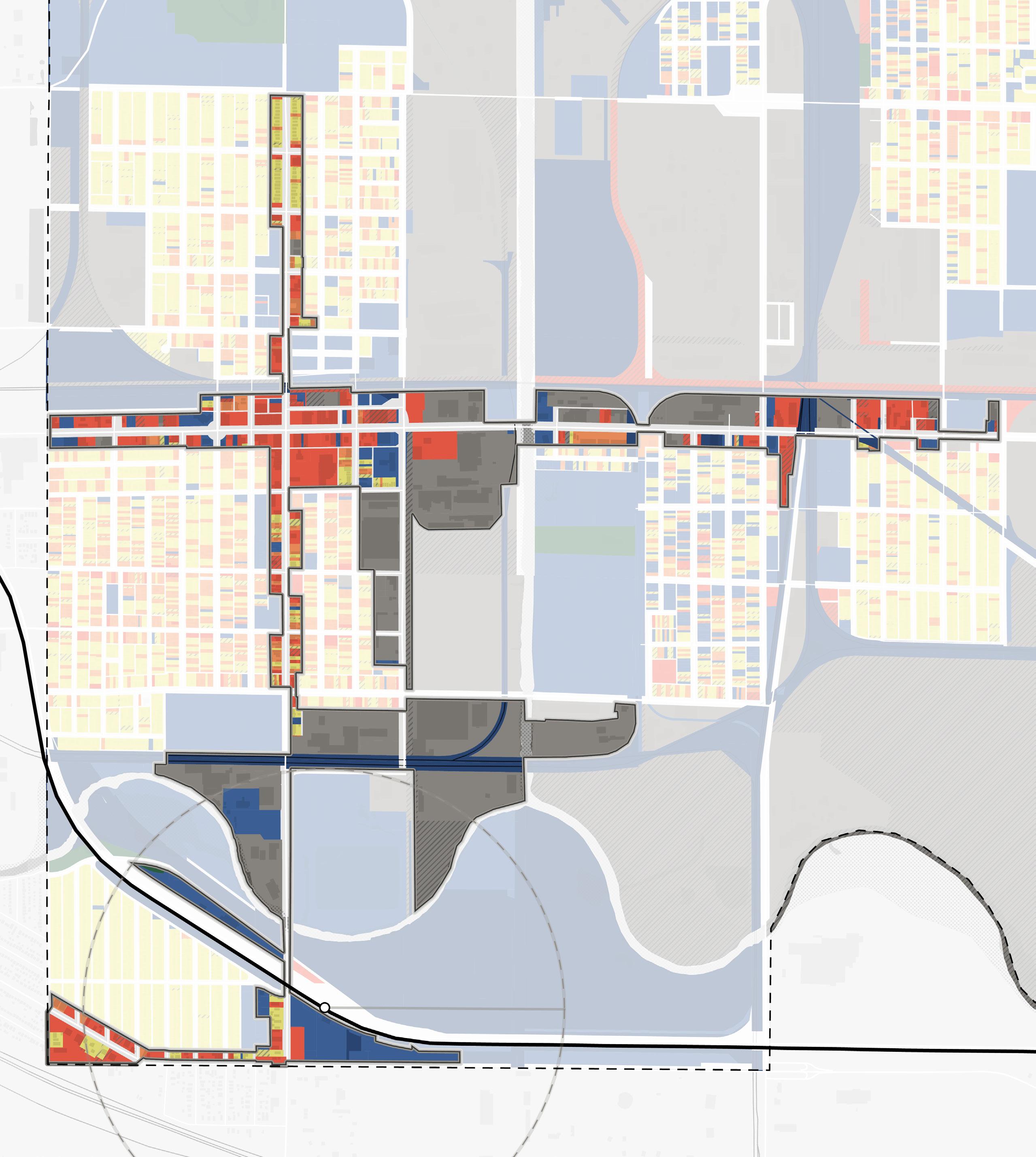
Existing Land Use
This area is a historic mix of industrial and residential development in a close area. There is a legacy of industry around the Grand Calumet River, the Indiana Harbor Canal, and the many railroad lines through this area. The Chicago Avenue corridor within the TDD boundary is primarily commercial use, with industrial uses straddling the canal. Indianapolis Boulevard is a mix of commercial and residential uses with the expectation of large industrial and publicly-owned properties surrounding the river. The area immediately around the South Shore Station consists of the Carrol Street commercial corridor, a tight block of single-family residential as the Roxana Neighborhood, and a large parking area for commuter parking.
East Chicago • East Chicago Station 23
Northwest Indiana TDD • TOD Strategic Implementation Plan 24
2016 Roxana TOD Plan - Highlighting Opportunities for TOD at the East Chicago Station
Future Land Use
The approach to future land use planning in this plan focuses on areas that are anticipated to change. Future land use is shown in general categories of land use to guide future land use and development decisions while allowing for flexibility in densities and building types. These land use descriptions also illustrate a general character and scale of the built environment recommended as most appropriate.
Other areas within the TDD boundaries that are not anticipated to change are not included in future land use planning. More detailed projections over 5-, 10-, and 20-year time horizons are mapped out for specific development sites included in this plan to represent a phased approach to development and land use.
Station Area
The Station Area use applies to the immediate land surrounding the NICTD Rail Station. This area includes the station platform, transit centers or amenities, parking lots or structures for transit riders, and maintenance yards. In the long term, some station areas may have the ability for Mixed-Use Joint Development to occur.
Mixed-Use Neighborhood
Mixed-Use Neighborhood land uses are medium-scale mixed-use areas that are often called town or village centers. They typically have compact development emphasizing connectivity and walkability with an accommodating public realm and storefronts that engage the street/pedestrians. The development pattern should be of appropriate scale in relation to the street and may include vertically integrated uses and horizontally integrated uses. Plazas, pocket parks, sidewalks, or activated alleys should serve as public spaces for residents, employees, and visitors. This typology provides retail and services to surrounding neighborhoods in a pedestrian-friendly environment, making it possible to accomplish several errands in a single trip.
Mixed-Use Node
Low-density mixed-use creates small activity nodes with a wide range of small businesses, housing types, and public facilities. These places are typically lower in building density, with larger lots that may accommodate off-street parking more than other land use types. Buildings can range from one to four stories in height as they relate to adjacent contexts and typically step down between areas with higher density to lower density. Businesses in this
typology typically serve adjacent neighborhoods and commuters. Uses may be mixed vertically in the same building in denser patterns or single-use standalone buildings integrating uses horizontally along a corridor in less dense patterns. These areas should promote walkability with pedestrian-scale amenities where possible, but these areas may also transition to more auto-oriented design because of its low density.
Neighborhood Commercial
Contains primarily single-story commercial, retail, and service businesses that are either in freestanding buildings or small, integrated centers. Development patterns tend to be more auto-oriented than mixed-use districts and are characterized by large parking areas, usually in front of or to the side of buildings, that may or may not be shared by adjacent uses. Along a corridor, there is typically a lack of adequate pedestrian facilities, bike facilities, and green space.
Industrial/Warehousing
Long-term light and heavy industrial uses that are characterized by operations for production, warehousing, distribution, etc. Heavier industrial uses may be more intense and should be concentrated in areas separated and buffered from other land uses. Where possible, industrial or truck traffic should be separated from local/residential traffic. In the case of lighter industrial, such as artisan manufacturing or small tech centers, these uses may be located adjacent to other uses, such as office/employment or retail/services, without causing compatibility or nuisance issues.
Conservation Area
Parks and natural areas are integral to the quality of life for residents, employees, and visitors. Green spaces vary in size depending on their character area context, and their appearance or purpose for the community. Conservation Areas include naturally occurring existing natural, undeveloped land such as National and State Park properties, river corridors, forests, or wetlands and intentionally-designed green spaces such as large-scale parks, greenway corridors, or recreation parks.
East Chicago • East Chicago Station 25
Future Land Use NORTH Station Area Mixed-Use Neighborhood Mixed-Use Node Neighborhood Commercial Industrial/Warehousing Conservation Area Northwest Indiana TDD • TOD Strategic Implementation Plan 26 90 South Shore Line East Chicago Station Kennedy Ave Euclid Ave 145th St 148th St Kennedy Ave Carrol St Kosciuszko Park City Hall and Veterans Park Marino/ WARE
Riley Park Roxana Marsh Roxana Park and Recreation Center 1/2 Mile EAST CHICAGO HAMMOND Corporate Limits EAST CHICAGO HAMMOND Corporate Limits GrandCalumet River 151st St 150th St W Columbus Dr White Oak Ave Railroad Ave Indianapolis Blvd Chicago Ave
Manufacturing Facility
Development Planning
Development Concepts
Within this TOD study area, two distinct strategies informed development opportunities that were tested more thoroughly. The primary strategy employed was to focus on sites with catalytic development potential that could spur investment by the private market in the short term. A secondary strategy was employed for long-term opportunities for which development potential is anticipated to increase with continued public and private investments as well as enabling infrastructure improvements. Specific development concepts were envisioned and analyzed by a range of development impacts that define an arc of development that supports East Chicago’s economic development path.
Four development opportunities were studied in this planning process were chosen to illustrate the potential of TOD in more detail with scenario planning and renderings.
East Chicago • East Chicago Station 27 RailroadAve
IndianapolisBlvd ChicagoAve CarrolSt 151stSt
Site C
Site A Site B
South Shore Line NORTH
Site E
Development Character
• Mixed-Use Node land use characterized by walkable development directly west of the East Chicago Station
• Redevelopment improves a key corridor into East Chicago, has the potential to provide amenities for the community, and build upon the adjacent park, library, and senior center.
• This development could contain ground-floor uses that are community-centered and complementary to Roxana Park, such as an updated library and senior center within the mixed-use building. This development could park with tuck-under parking and shared or leased parking with the park or NICTD parking lot.
• This site has the potential to attract market-rate or senior tax credit development
• A public plaza space is located on South Roxana Drive that activates this corner and the ground-floor commercial of the building
IndianapolisBlvd I-90 NORTH
Site A
Development Program 5.3 Acres Commercial 7,300 SF Mixed-Use 57 Residential Units 8,000 SF Commercial Northwest Indiana TDD • TOD Strategic Implementation Plan 28
Roxana Recreation Center
Development Character
• Neighborhood Commercial, Conservation Area, and Mixed-Use Node land uses characterized by trail-oriented development adjacent to the Marquette Greenway, Roxana Marsh, and the Grand Calumet River
• The southernmost portion of the site where the Knights of Columbus operate the Columbian Club could include some commercial and/or parks and recreation uses to activate the Roxana Marsh and Grand Calumet River
• Opportunity to redevelop industrial property and situate housing near the Marquette Greenway and Kosciuszko Park
• Development of these sites is restricted by the 100-year floodplain. Areas within the 100-year floodplain could function as sensitively-designed park spaces or parking areas serving the development.
• Frontage along Indianapolis Boulevard is created as much as possible, while navigating floodplain restrictions, with commercial frontage to the south, but development to the north is setback to avoid the floodplain
IndianapolisBlvd MarquetteGreenway
I-90
Columbian Club of East Chicago
NORTH Development Program 29.7Acres Commercial 6,500 SF Multi-Family Residential 195 Units East Chicago • East Chicago Station 29
Kosciuszko Park
Site B
Development Character
• Mixed-Use Node characterized by trail-oriented development linking to Marquette Greenway and Kosciuszko Park, inclusive of green space that serves residents and trail users
• Redevelopment transitions from industrial uses to create a critical mass of housing complementary to the scale of the existing residential area to the north
• Indianapolis Boulevard frontage is activated by small-scale commercial, and the eastern edge of the site is an opportunity for light industrial/ flex uses that are more appropriate adjacent to existing industrial properties near Railroad Avenue
IndianapolisBlvd
151stSt Kosciuszko Park East Chicago Sanitary District Site C NORTH Development Program 17.4 Acres Commercial 9,000 SF Townhomes 118 Units Employment Flex/Light Industrial 37,000 SF Northwest Indiana TDD • TOD Strategic Implementation Plan 30
RailroadAve 152ndSt
Development Character
• Mixed-Use Neighborhood land use along Chicago Avenue (IN 312), infilling vacant and underperforming properties to create walkable, mixed-use development
• While this development site is not considered TOD due to its distance from the station, it is an important opportunity within the TDD boundary
• This site includes a mix of townhomes, preservation of existing buildings along Chicago Avenue, and mixed-use market-rate development on the corner of Chicago and Railroad Avenues
WChicagoAve
148th St East Chicago • East Chicago Station 31
TodAve RailroadAve
W
Strack & Van Til
E NORTH Development Program 10.7Acres Townhomes 79 Units Multi-Family Residential 79 Units Mixed-Use 162 Residential Units 8,000 SF Commercial
Salvation Army
Site
Northwest Indiana TDD • TOD Strategic Implementation Plan 32
This page is intentionally blank.
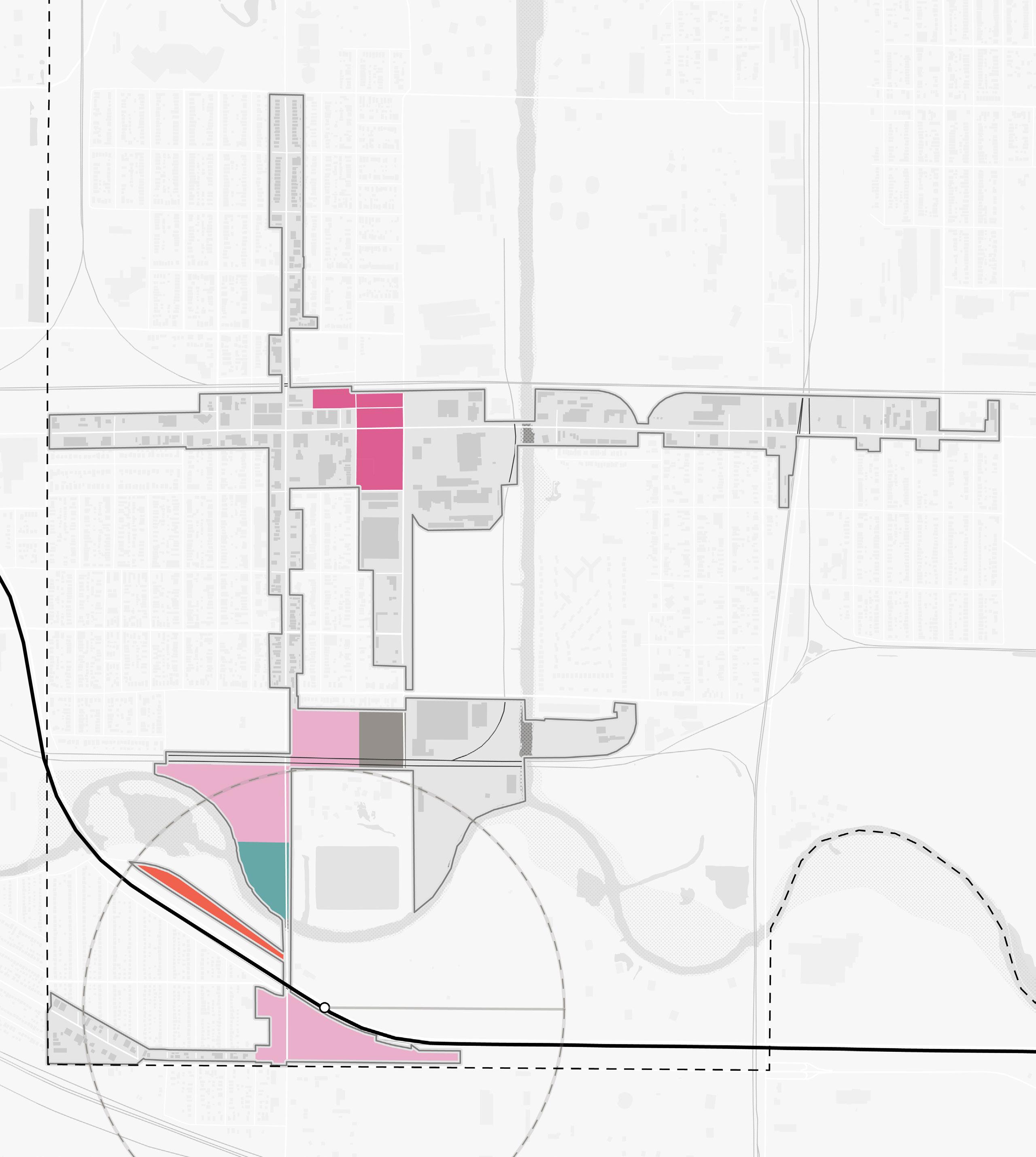
Arc of Development
At this level of study, it is difficult to assign exact timeframes to development, but this plan demonstrates a range of development and illustrates a potential arc of development over time that could be possible with the right set of incentives and conditions supported by the market.
To understand the full range of potential of these sites, high-level capacity tests were conducted using various densities and types of development possible for each community. Estimations of several metrics of community impacts, including population changes, jobs created, and generated vehicle trips, were calculated based on future potential development. These impacts were informed by market analysis conducted by KPMG and Policy Analytics, ownership status, local guidance and interest, and quantitative and qualitative planning analysis.
The arc of development for each community was defined collectively for selected development opportunities within the TDD boundary that projects future development potential over 5-, 10-, and 20-year time horizons. Quantitative and qualitative factors such as local/public property control, developer engagement or interest, site conditions, current regulations or future regulatory changes, among others were considered in determining the arc of development over time. This study is confident, however, that investments outlined herein can change the outlook and perception of this area and thus induce the private development market over time.
Projected Land Use & Development: 5-Year Horizon
Projected Land Use & Development: 10-Year Horizon
Projected Land Use & Development: 20-Year Horizon
Station Area
Mixed-Use Neighborhood
Mixed-Use Node
Neighborhood Commercial Conservation Area
South Shore Line South Shore Line South Shore Line Chicago Ave Carrol St Indianapolis Blvd Chicago Ave Carrol St Indianapolis Blvd Chicago Ave Carrol St Indianapolis Blvd East Chicago • East Chicago Station 35
Impact Projections
* Vehicle trips generated include projected commuters in 2022 and in 2040 at full build out
** Source: NICTD
Land Use Total Development in Acres 14.38 - 46.97 Acres Total Development in Sq. Ft. 626,300 - 2,046,000 SF Retail Development 18,000 - 150,000 SF Industrial Development ± 190,000 SF Office Development 88,300 - 453,100 SF Multi-Family Residential Development 330,000 - 1,252,900 SF Residential Housing Units Total Housing Units 220 - 1,055 Rental Units 115 - 860 Owner-Occupied Units 105 - 195 Projected Impacts Residential Population Increase 595 - 2,220 Households with School-Aged Children 110 - 405 Employees 75 - 350 Vehicle Trips Generated* 3,500 - 10,690 (2022)** 3,500
10,690 (2040)**
-
Northwest Indiana TDD • TOD Strategic Implementation Plan 36
Documentation and Analysis
Functional Classifications
Functional Classifications, determined by INDOT, were documented and used in analysis to understand the hierarchy of corridors in each community. These classifications also helped inform street design and public realm character typologies.
The East Chicago TOD study area is well-connected by several major regional and local corridors. Indianapolis Boulevard (US 20) and Michigan/Carrol Streets and are the Primary Arterial corridors that lead into this portion of East Chicago. Other major routes include Chicago Avenue (IN 312), Kennedy Avenue, and Railroad Avenue. There is also a network of neighborhood streets in a regular grid. Barriers in this area are the elevated South Shore Line and I-90/ Indiana Toll Road, the Grand Calumet River, and the Roxana Marsh separating the area near the station from walkable portions of the city further north.
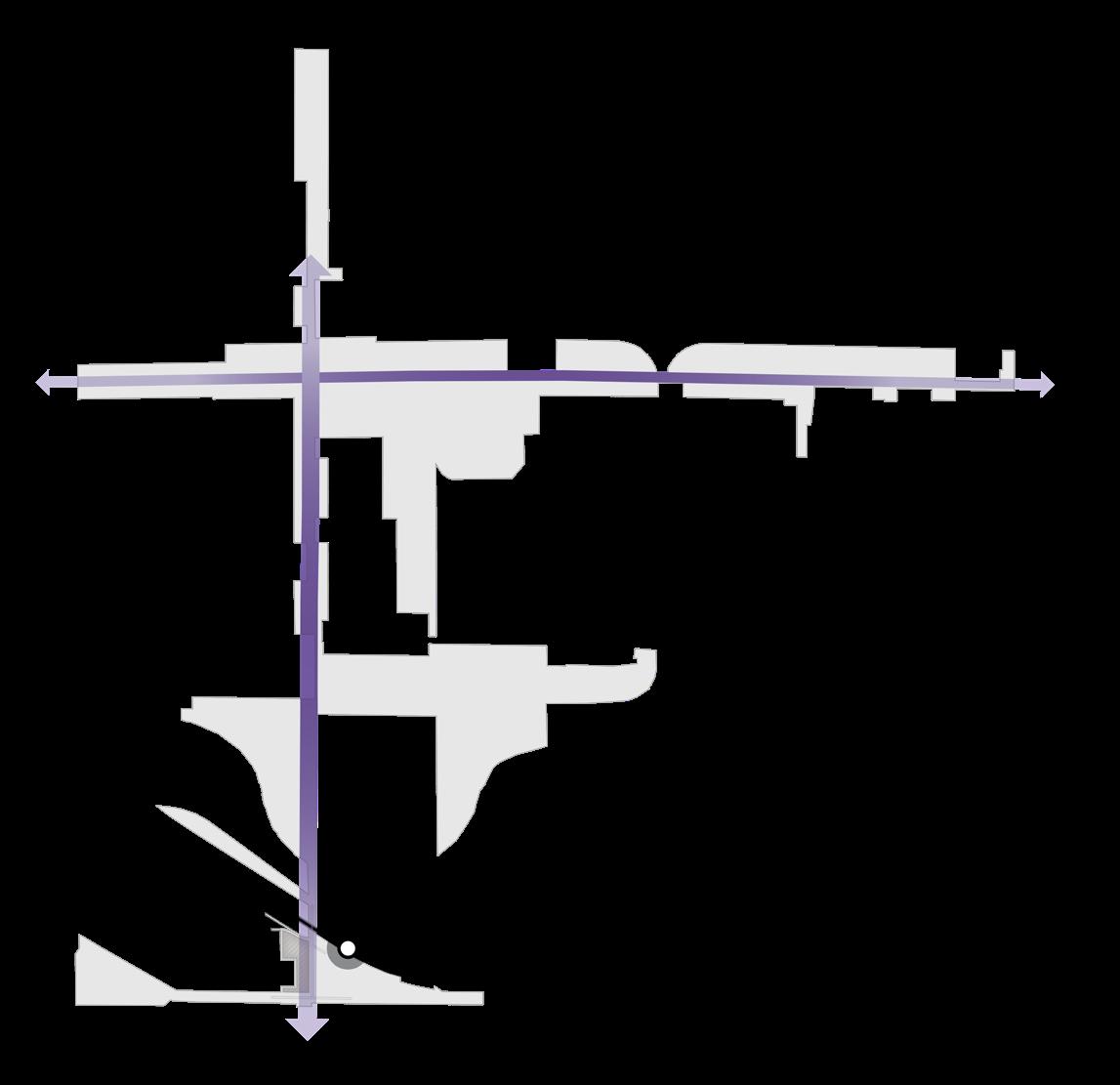
Connectivity
The East Chicago TDD boundary is linear, following Indianapolis Boulevard and Chicago Avenue. As a result, much of the area north of the East Chicago Station and I-90 is unwalkable. The Marquette Greenway alignment is planned to connect from approximately 151st Street south down Indianapolis Boulevard to the station. There is potential to provide high-quality pedestrian connectivity from the station along this corridor, leveraging the funded Marquette Greenway to link to nearby neighborhoods.
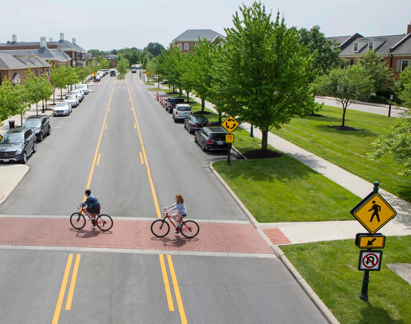
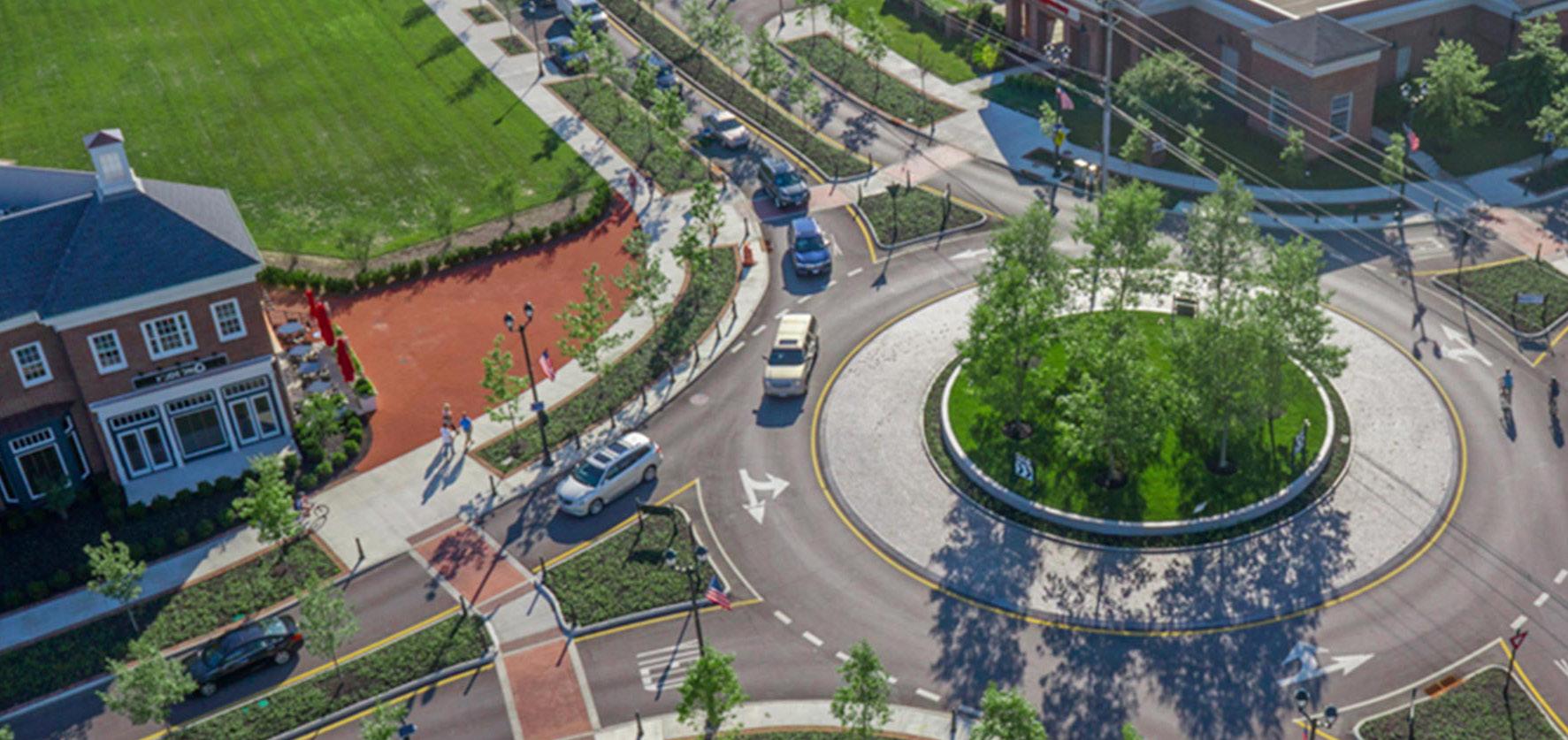
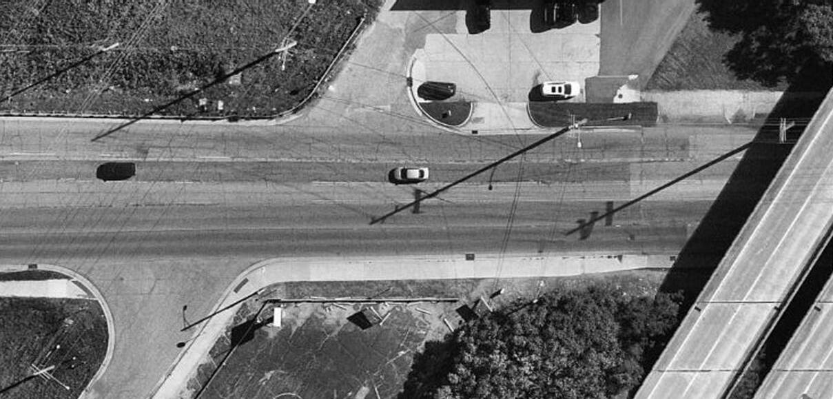
A priority of the City is to re-imagine Indianapolis Boulevard as a Complete Street. A Complete Street defines a holistic approach towards the building, operating, and maintaining streets that enables safe access for all, including pedestrians, bicyclists, motorists, and transit riders of all ages and abilities. INDOT is improving Indianapolis Boulevard north of 151st Street to include formalized on-street parking.
East Chicago • East Chicago Station 37
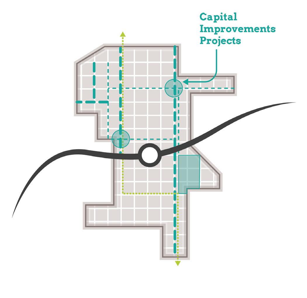
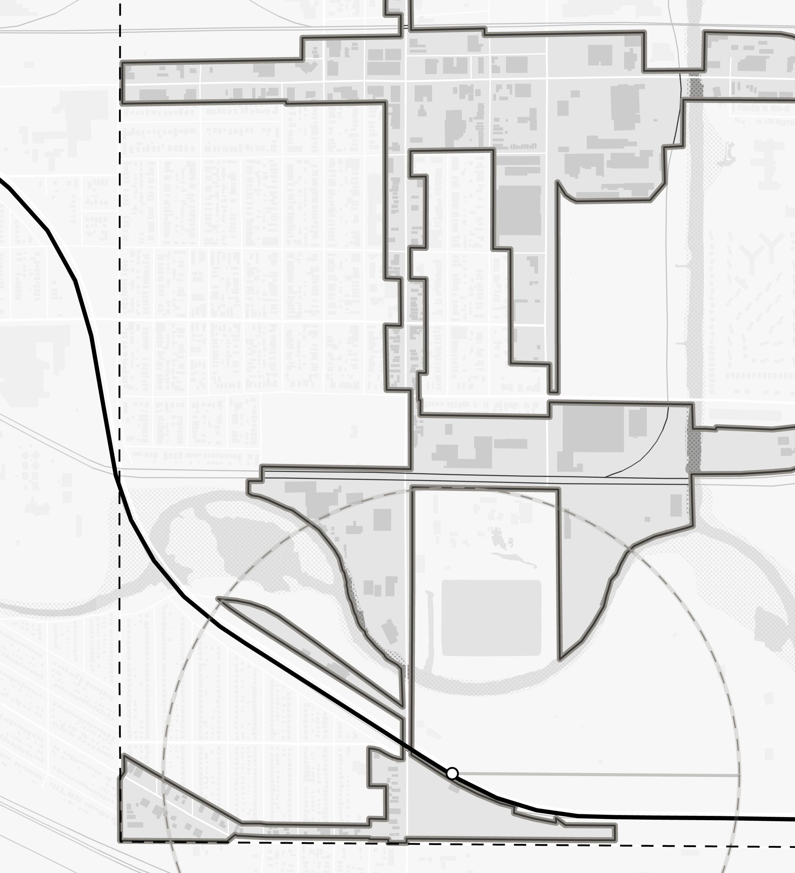
Infrastructure
Functional Classifications Shell St Michigan St Baring Ave Northcote Ave 145th St 150th St 151st St Euclid Ave Kennedy Ave Railroad Ave Kennedy Ave Chicago St Carrol St W Columbus Dr Indianapolis Blvd South Shore Line City Hall and Veterans Park Roxana Marsh Roxana Park and Recreation Center White Oak Ave 90 Freeways (Interstates) Principal Arterial Minor Arterial Major Collector Minor Collector NORTH East Chicago Station Northwest Indiana TDD • TOD Strategic Implementation Plan 38 Kosciuszko Park
Riley
1/2 Mile EAST CHICAGO HAMMOND Corporate Limits GrandCalumet River
Marino/ WARE Manufacturing Facility
Park
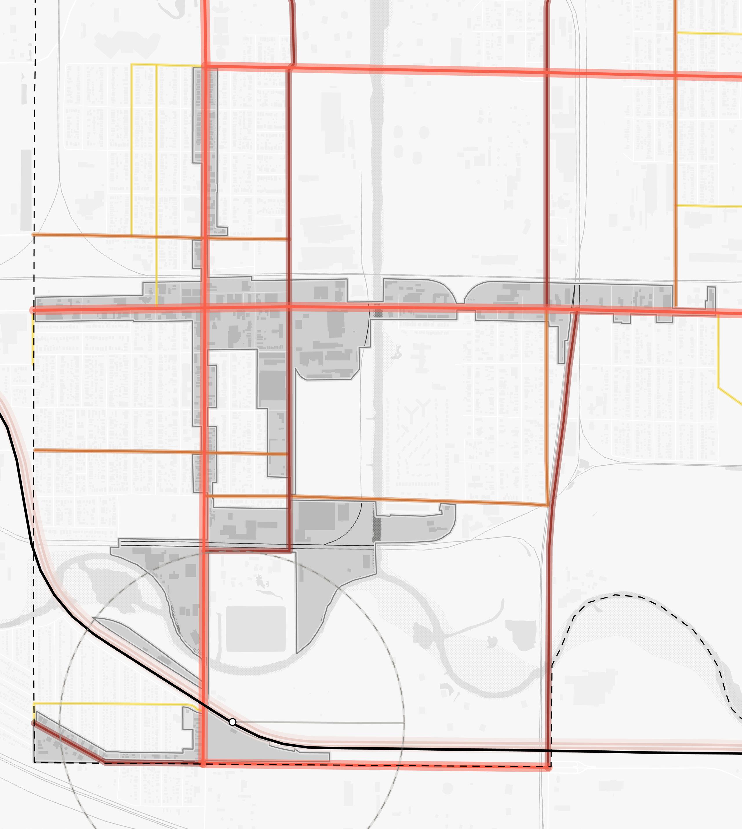
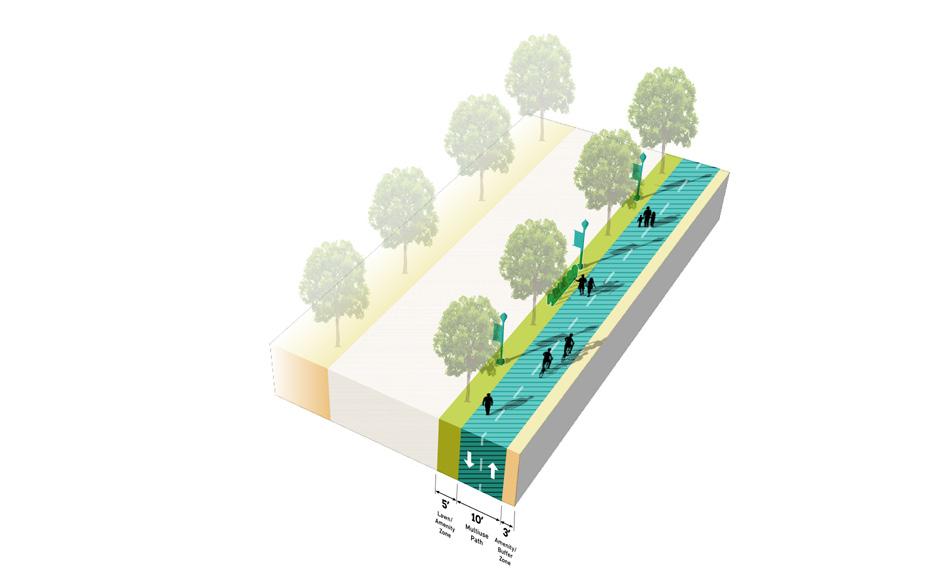
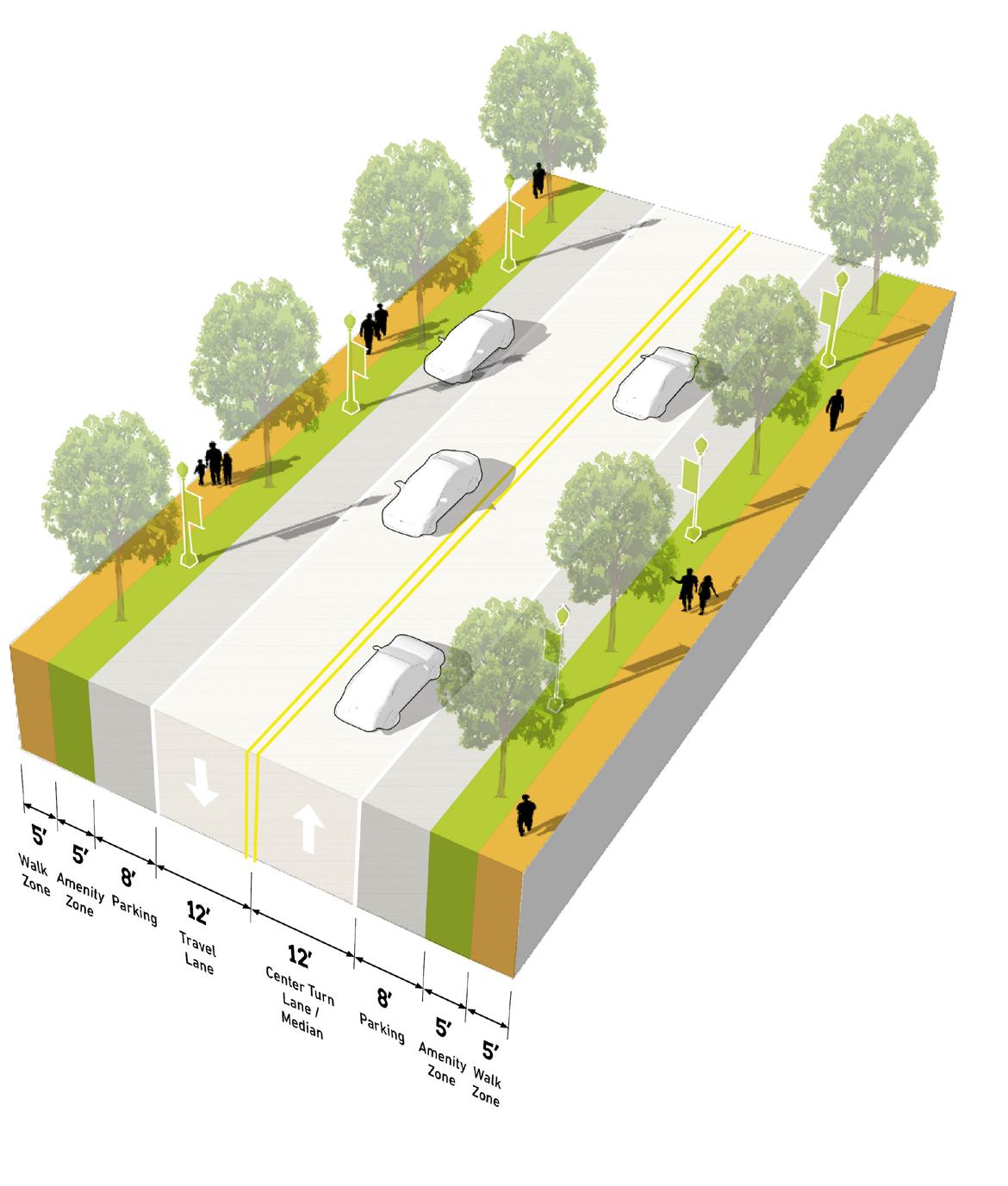
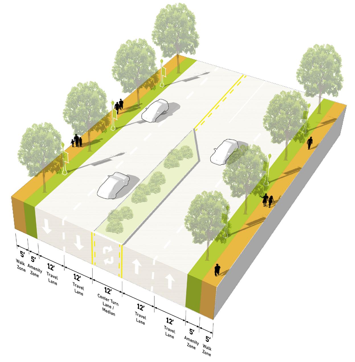
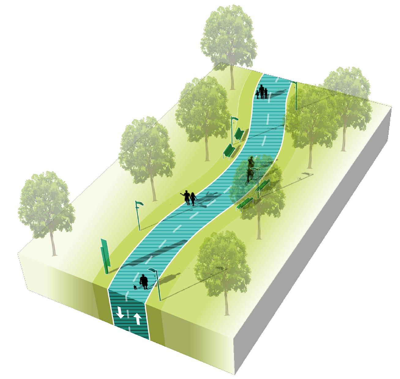
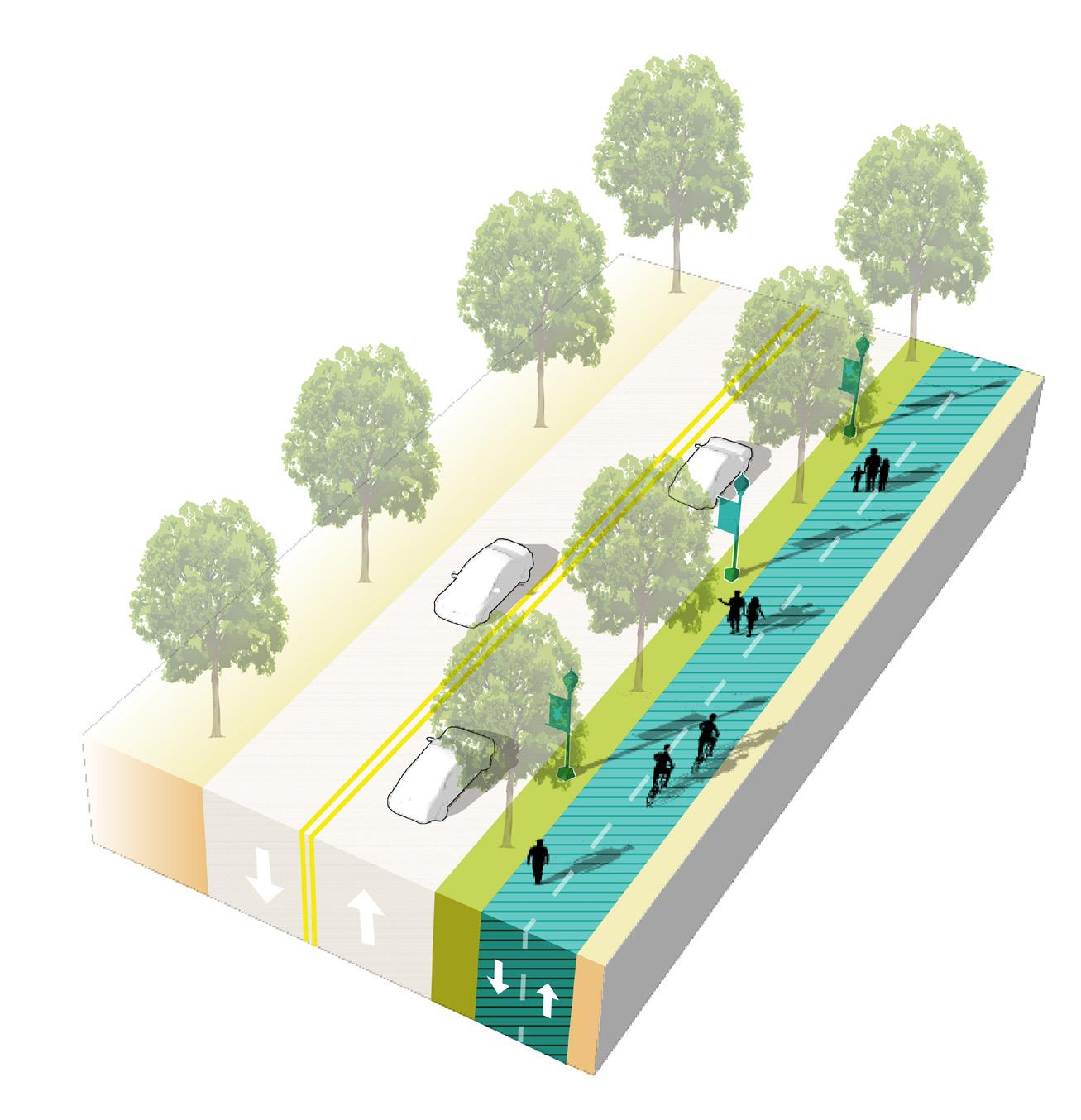
Thoroughfare Typologies
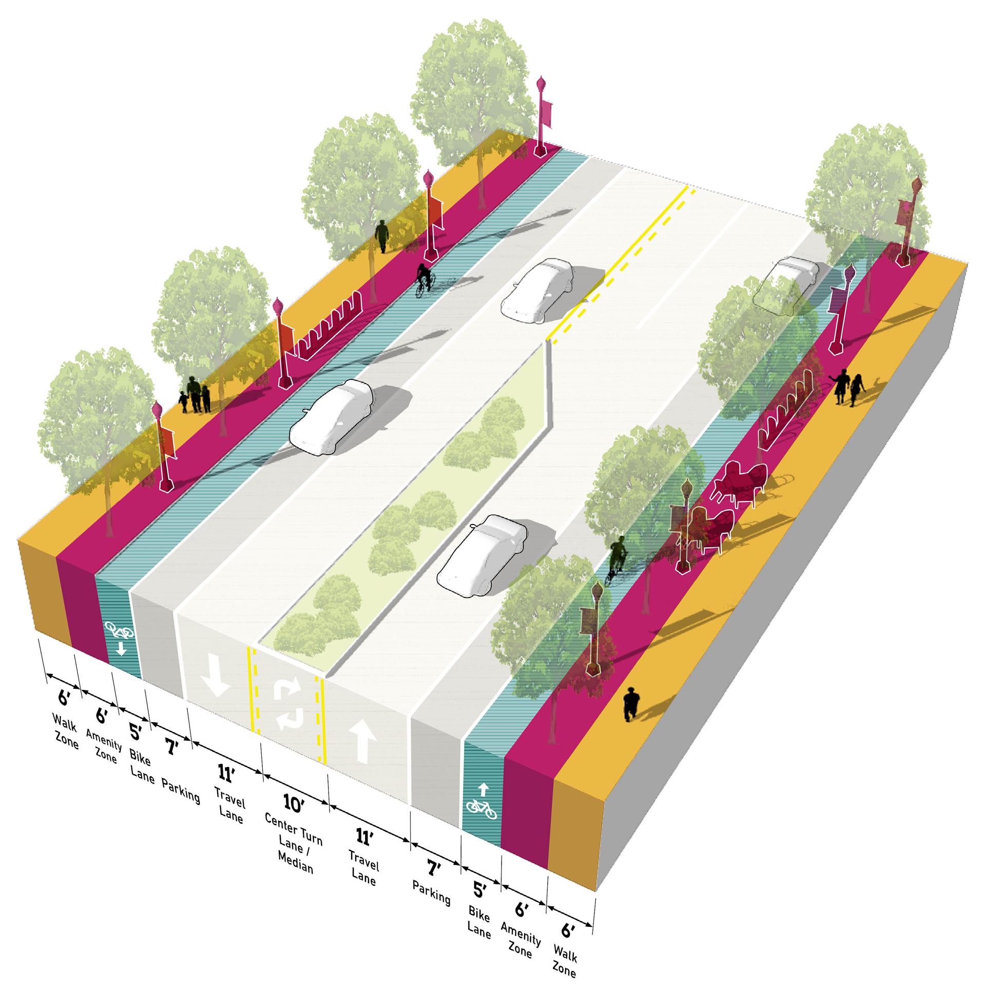
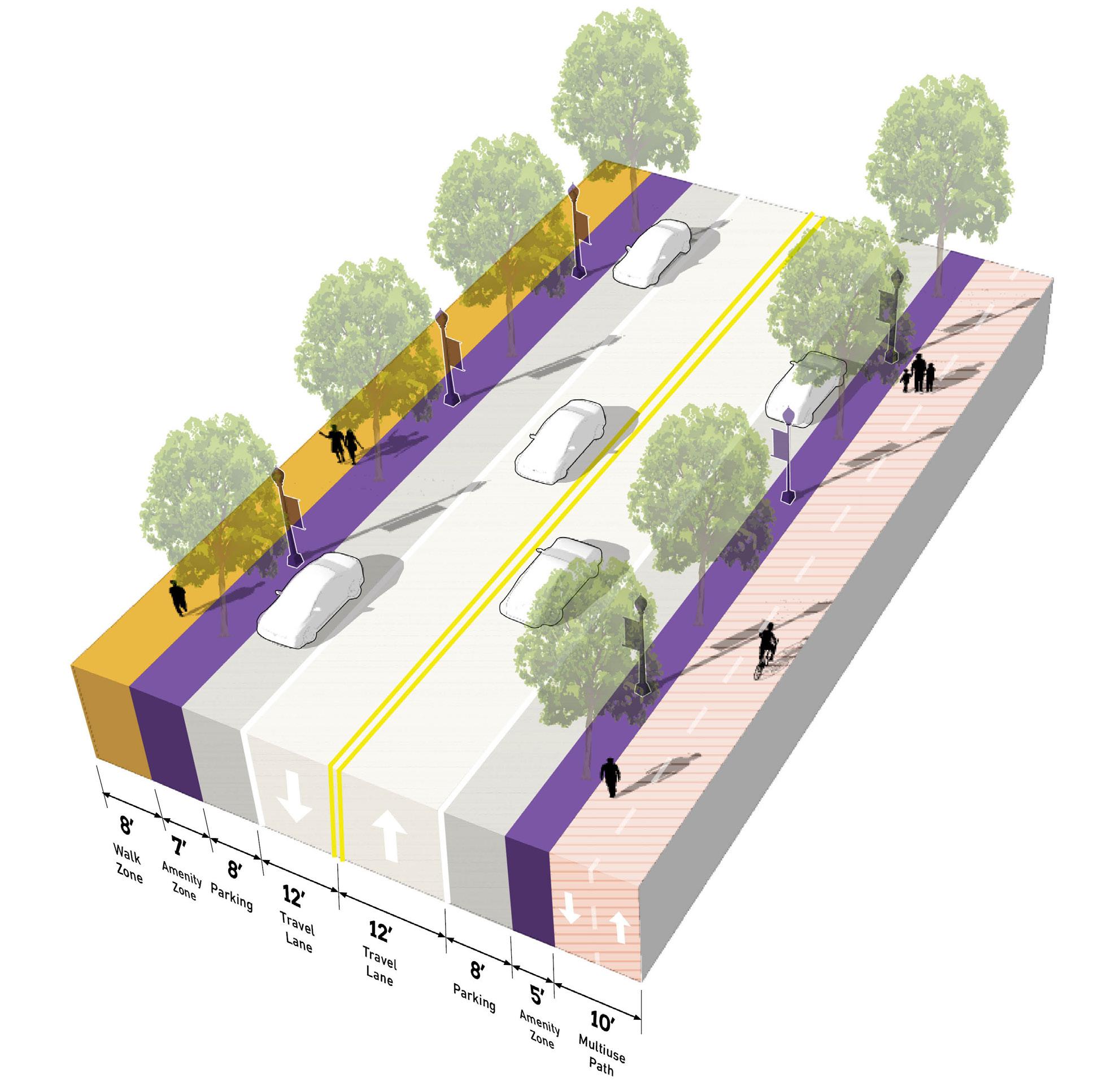
Thoroughfare Typologies were developed to analyze existing corridor conditions and create aspirational goals for future street design and streetscape. Typologies focused on important corridor segments within and connecting to the TDD boundary to guide the design and character of roadways, sidewalks, and amenities within the public right-of-way. These typologies depict typical elements of corridors, including the number of travel lanes, landscaping, lighting, bicycle infrastructure, and sidewalks and paths.
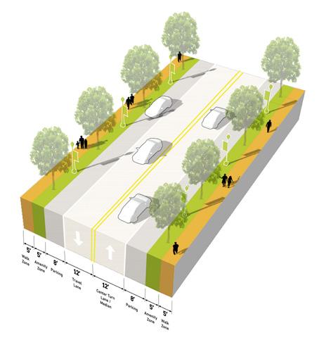
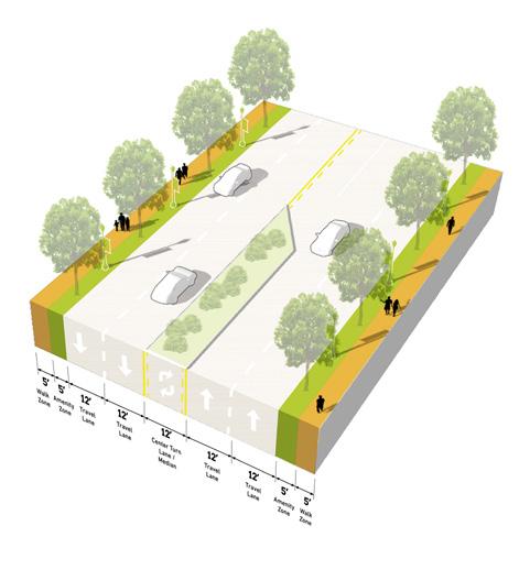
A portion of Indianapolis Boulevard, between 151st Street and Carrol Street, is designated as a TOD Priority Thoroughfare for its prominence in connecting the rest of the community to the station area and the need for safety improvements to promote TOD. North of 151st Street, Indianapolis Boulevard is a TOD Connector, and an INDOT improvement project is underway for this segment. South Roxana Drive is also a TOD Connector that leads from the Roxana Neighborhood to Indianapolis Boulevard and the station. Key Vehicular routes include Chicago Avenue, Kennedy Avenue, 151st Street, Carrol Street, and Michigan Street, as they make major vehicular connections throughout East Chicago and the TDD boundary. The Marquette Greenway has been built along the former railroad right-of-way south of Kosciusko Park, connecting from Hammond; an extension is planned to construct the greenway east of Indianapolis Boulevard. Enhancing pedestrian connectivity along South Roxana Drive, Chicago Avenue, and Indianapolis Boulevard will enhance walkability to the station area and throughout the city.
East Chicago • East Chicago Station 39
Pedestrian Route TOD Priority Thoroughfare
Connector Key Vehicular Route Trail/Greenway
Key
TOD
Northwest Indiana TDD • TOD Strategic Implementation Plan 40 Thoroughfare Typologies 151st St Kennedy Ave Kennedy Ave Chicago Ave Carrol St Indianapolis Blvd Indianapolis Blvd SRoxanaDr Marquette Greenway Proposed Marquette Greenway Michigan St 150th St TOD Priority Thoroughfare TOD Connector Key Vehicular Route Existing Trail/Greenway Key Pedestrian Route NORTH 90 South Shore Line Euclid Ave 145th St 148th St Kosciuszko Park City Hall and Veterans Park Marino/ WARE Manufacturing Facility Riley Park Roxana Marsh Roxana Park and Recreation Center 1/2 Mile EAST CHICAGO HAMMOND Corporate Limits EAST CHICAGO HAMMOND Corporate Limits GrandCalumet River W Columbus Dr White Oak Ave Railroad Ave East Chicago Station
TOD Priority
Thoroughfare
Designed as a Complete Street, accommodating all modes of transportation with high-quality facilities, amenities, and public realm
TOD Priority Thoroughfares support the highest intensity of activity, at local and regional scales. The function of these corridors is primarily to provide multi-modal access to the Station Area and to generate street-level activity for a mix of uses. These corridors will likely carry a high volume of traffic, but at lower vehicle speeds to also accommodate safe, highly-walkable conditions for pedestrians and bicyclists. An attractive, high-quality public realm provides abundant amenities for pedestrians and bicyclists, creating a safe and comfortable environment and establishing an identity/ sense of place. Buildings are typically oriented toward the sidewalk with active ground floor uses. Sidewalks should be wide enough to accommodate a clear walking path along with amenities such as street trees, planters, landscaping, outdoor dining, and gathering areas. Transit is also highly accessible along TOD Priority Thoroughfares, and transit stops should be enhanced and designed as part of the public realm. Parking is typically provided on-street, and access to development blocks or off-street parking should not occur directly from the corridor.
East Chicago Station
Number of Lanes/ Target Speed
Non-motorized Facilities
Bus/transit Facilities
Parking
Access Management
Public Realm Design/Amenities
2-4 lanes / 25-35 mph
Dedicated facilities (dedicated/separated bike lanes, sharrows, multi-use paths) wide sidewalks; frequent crossings that are well-designed and enhanced for safety and access, including mid-block crossings where necessary
Well-served by bus/transit; enhanced transit stops including shelters and other amenities; Station Area as a hub for transit facilities; bus pull-off or drop-off zones encouraged
On-street parking; any off-street parking, either structured garages or surface lots, should be to the rear of buildings, interior to blocks, and/or properly screened and well-designed with landscaping
Very limited to no driveways in the TOD Station Area; shared parking among buildings and uses is highly encouraged to reduce the number of driveways; driveways, if present, should be adequately spaced and offset to prevent conflicts; consolidation of existing driveways should be studied
High quality and active public realm design with abundant amenities for pedestrians and bicyclists; design should be reflective of the community character and identity; sidewalks should provide adequate clear space for pedestrian circulation
Northwest Indiana TDD • TOD Strategic Implementation Plan 42
TOD Priority Thoroughfare
TOD Connector
Multi-modal street that balances modes of transportation to connect to other major facilities, with high-quality public realm and frequent amenities
TOD Connector Thoroughfares may vary more in density of development and intensity of uses, depending on the context. These corridors serve to provide access to TOD Priority Corridors, transit-oriented development and the Station Area for the broader community and connect to other key destinations. TOD Connectors are multi-modal in design with lower vehicular speeds, connected pedestrian and bicycle networks, and transit stops. Bicycle infrastructure may vary from dedicated facilities to shared streets, depending on available right-of-way. A high-quality public realm should continue along these corridors, but may be less intense or frequent in amenities depending on right-of-way and context. Buildings are typically oriented toward the sidewalk with active ground floor uses, but setbacks may increase with a decrease in density. Driveways, both residential and commercial, may be present along the corridor, but infrequent; access management should ensure safe entry/exit along the corridor. Parking is typically provided on-street, and access to development blocks or off-street parking should not occur directly from the corridor.
Number of Lanes/ Target Speed
Non-motorized Facilities
Bus/transit Facilities
Parking
Access Management
Public Realm Design/Amenities
2-4 lanes / 25-35 mph
Connecting gaps of existing facilities (dedicated/separated bike lanes, sharrows, multi-use paths, sidewalks, well-designed and enhanced crossings); enhancing existing facilities to improve safety and accessibility
Well-served by bus/transit; enhanced transit stops including shelters and other amenities; bus pull-off or drop-off zones encouraged
On-street parking; any off-street parking, either structured garages or surface lots, should be to the rear of buildings, interior to blocks, and/or properly screened and well-designed with landscaping
Limited driveways along corridor; shared parking among buildings and uses is highly encouraged to reduce the number of driveways; driveways, if present, should be adequately spaced and offset to prevent conflicts; consolidation of existing driveways should be studied
High quality and active public realm design with many amenities for pedestrians and bicyclists; design should be reflective of the community character and identity; sidewalks should provide adequate clear space for pedestrian circulation
Northwest Indiana TDD • TOD Strategic Implementation Plan 44
TOD Connector
Key Vehicular Route
Primarily functions for vehicular travel but ensures adequate access and safety for all other modes along the corridor, connects to other facilities in the community
Key Vehicular Routes serve areas of moderate density and transition areas to more residential or neighborhood scale areas of the community. These corridors are more auto-oriented, linking residents to major community destinations, services, and amenities, but should still contribute to the network of safe and comfortable pedestrian and bicycle facilities. Transit service may be less frequent on these thoroughfares, but should still be accessible to important transit routes. Vehicular speeds are low along these thoroughfares, and the public realm may be less formal in design, especially in residential areas. However, quality design should still contribute to a sense of place along these corridors. On-street parking may exist in denser areas, and residential and commercial driveways are more frequent along Key Vehicular Routes, especially in more suburban-style development areas. New development should establish a high level of public realm and prevent or mitigate any vehicular conflicts through access management interventions. Parking is typically provided on-street, and access to development blocks or off-street parking should not occur directly from the thoroughfare.
Number of Lanes/Target Speed 2 lanes / 20-25 mph
Non-motorized Facilities
Connecting gaps of existing facilities and access to enhanced facilities (sharrows, multi-use paths, sidewalks, well-designed and enhanced crossings); focus on balancing of modes
Bus/transit Facilities
Some bus/transit facilities, less frequent but enhanced transit stops; stops should be located at key destinations
Parking
On-street parking; any off-street parking, either structured garages or surface lots, should be to the rear of buildings, interior to blocks, and/or properly screened and well-designed with landscaping (if visible from corridor)
Access Management
Public realm design with basic amenities for pedestrians and bicyclists; design should be reflective of the community character and identity; sidewalks should provide adequate clear space for pedestrian circulation
Public Realm
Design/ Amenities
High quality and active public realm design with many amenities for pedestrians and bicyclists; design should be reflective of the community character and identity; sidewalks should provide adequate clear space for pedestrian circulation
Northwest Indiana TDD • TOD Strategic Implementation Plan 46
Key
Vehicular Route
Key Pedestrian Route
Functions primarily for pedestrians, typically as a highly-designed pathway or as a trail or greenway, and may also accommodate bicyclists
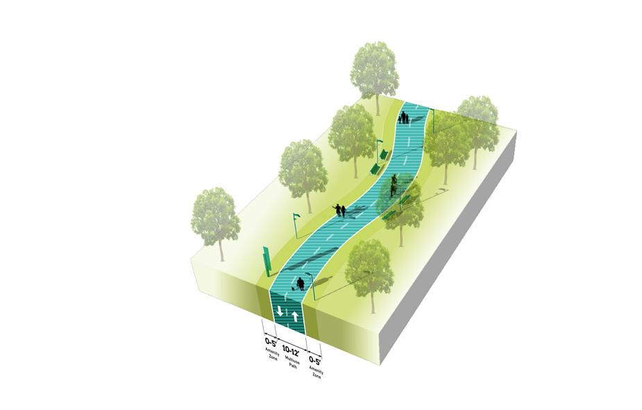
Key Pedestrian Routes primarily serve pedestrians to connect to key destinations, transit access, and the Station Area. These routes may exist alongside vehicular corridors or they may exist in the form of a pedestrian pathway or trail. In the case of a trail, bicycles may also be accommodated. Amenities and landscaping should be designed at pedestrian-scale and either contribute to the surrounding character or to particular brand if part of a larger trail network. Wayfinding and signage is particularly important to highlight access points and destinations across the community. New Key Pedestrian Routes should be planned to avoid vehicular conflicts such as driveways, and these conflicts should be reduced to the extent possible along existing Key Pedestrian Routes.

Number of Lanes/Target Speed N/A or Varies
Non-motorized Facilities
Completing gaps of existing facilities and access to enhanced facilities (sidewalks, multi-use paths, and well-design and enhanced crossings where intersecting with roadways); may exist along roadways or as a separated facilities like a path or trail
Bus/transit Facilities
Some bus/transit facilities, less frequent but enhanced transit stops; stops should be well-connected by a complete network of pedestrian facilities
Parking
Parking areas, on-street or off-street, should be located near trailheads. Pedestrian routes may connect parking areas to other destinations in the community.
Access Management
Limited driveways intersecting with pedestrian routes to reduce conflicts with vehicle entries/exits and maximize pedestrian safety. New pedestrian routes should be planned along corridors with minimal driveway conflicts, or access management interventions may be implemented.
Public Realm Design/ Amenities
Amenities along pedestrian routes should be tailored to pedestrians (or bicyclists if a multi-use path or trail); design should be reflective of the community character and identity;local or regional trails may be designed with individual branding
Northwest Indiana TDD • TOD Strategic Implementation Plan 48
Key Pedestrian Route
Thoroughfare & Streetscape Design
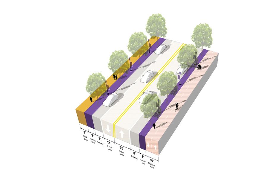
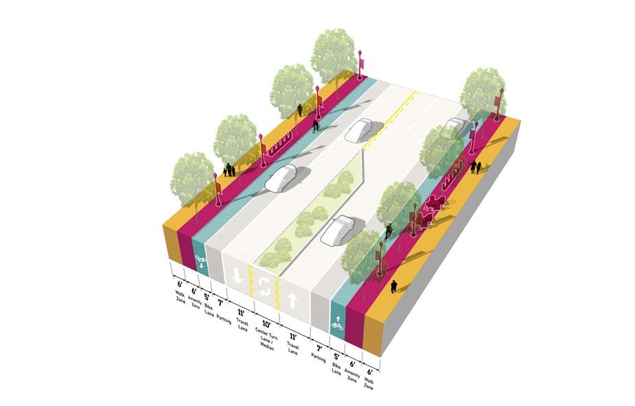
Further studies were conducted on TOD Priority Thoroughfares at the request of the local units. These studies and the corresponding order of magnitude cost estimates are included in determining possibilities for infrastructure improvements that could catalyze TOD close to the station. These studies provide concept-level plans that communities could use to have conversations with stakeholders/funders, such as NIRPC and INDOT, and with local elected, appointed, and staff-level officials about the importance of high-quality infrastructure in the creation of TOD.
This study focuses on Indianapolis Boulevard south of 151st Street to complement the on-going improvements led by INDOT north of 151st Street. Indianapolis Boulevard is currently unsafe for both pedestrians and vehicles, and it should be a priority for this corridor to enhance walkability to the East Chicago Station and future development.
East Chicago • East Chicago Station 49
NORTH South Roxana Drive Marquette Greenway Connection 90 South Shore Line Chicago Ave Railroad Ave Carrol St MichiganSt SRoxanaDrNRoxanaDr Grand CalumetRiver 151st St East Chicago Station 152nd St & Marquette Greenway Carrol Street Indianapolis Blvd North Roxana Drive EAST CHICAGO HAMMOND Corporate Limits On-going INDOT Improvements Area
of Further Study
Indianapolis Boulevard at 152nd Street & Marquette Greenway
Improvements for Indianapolis Boulevard focus on converting a street that complicates pedestrian circulation into a corridor that facilitates multi-modal transportation. Where the existing Marquette Greenway ends on the west side of Indianapolis Boulevard, a safe pedestrian crossing is envisioned at a stoplight just to the south to facilitate the extension of the trail network eastward. Similarly, enhancements are made to increase the presence of the trail crossing at the I-90/Indiana Toll Road and South Shore Line overpass to increase driver awareness and promote safety. Added signs and/or signals, pavement texture changes, and dynamic crosswalk paint can be used to alert drivers to the presence of a pedestrian crossing.
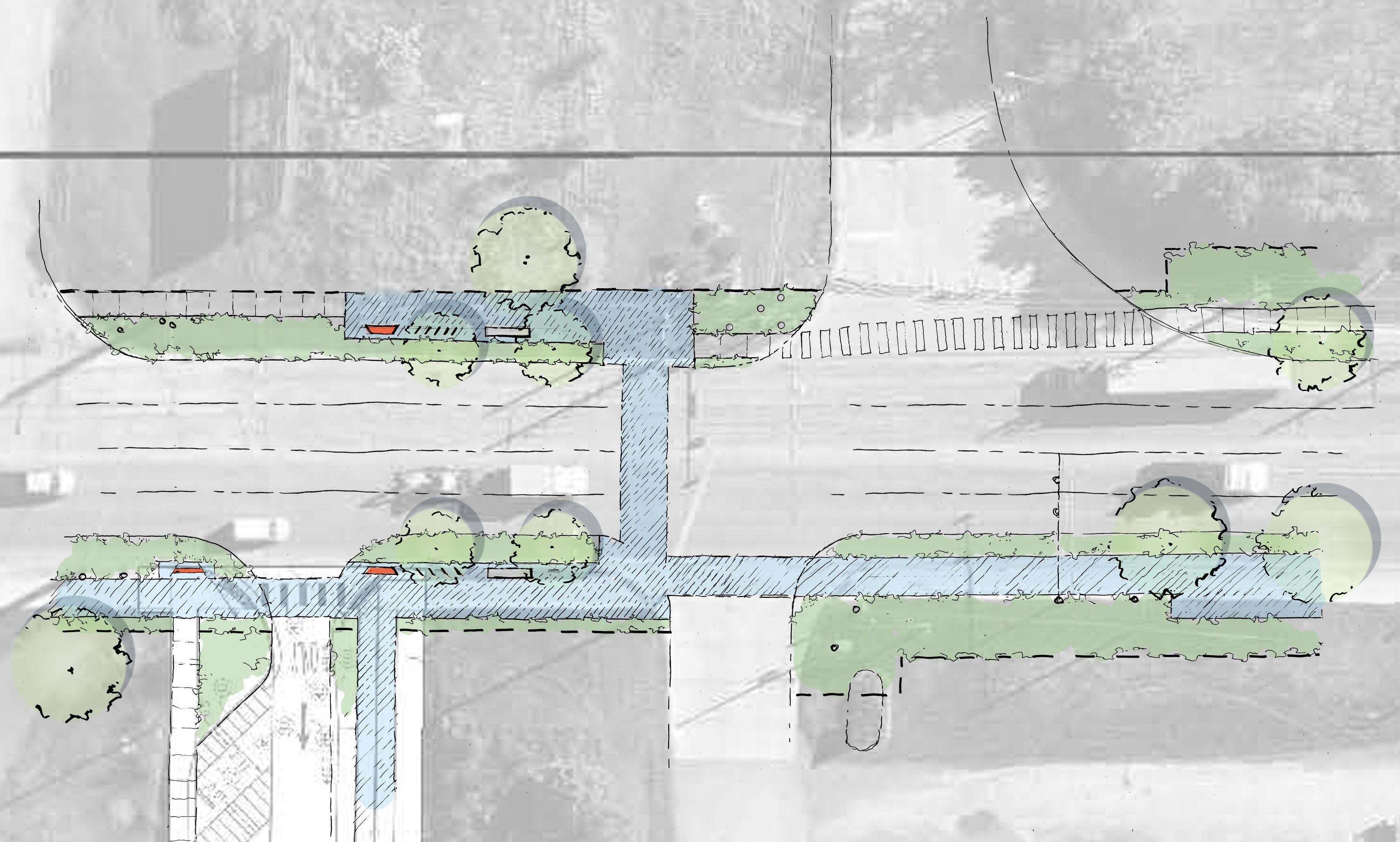

Conceptual Sketch of Indianapolis Boulevard at 152nd Street & Existing Marquette Greenway Northwest Indiana TDD • TOD Strategic Implementation Plan 50
Existing Driveway Vacated Railroad Right-of-way Vacated Railroad Right-of-way 152nd St Indianapolis Blvd NORTH 100’ ROW 6’ Walk Parklet with
& Seating 6’ Planting with Street Trees Wayfinding/ Trail Signage 10’ Multi-use Path 8’ Planting Area with Smaller Street Trees Parklet with Bike Rack & Seating Sidewalk Connects to Planned Improvements 152nd St Existing Driveway Kosciuszko Park Potential Development Potential Development Indianapolis Blvd Existing Marquette Greenway 90’ ROW Existing Conditions
Bike Rack
Indianapolis Boulevard at North Roxana Drive
A consistent minimum 90’ right-of-way is sought throughout the corridor where utility encroachments or other oddities encroach on the space needed for a multi-use path. Lane widths are reduced where possible to calm traffic throughout the corridor, and planted medians are introduced to green the corridor and restrict left turn movements where necessary. Street trees are also added to provide a more comfortable and protected environment for trail users and pedestrians.
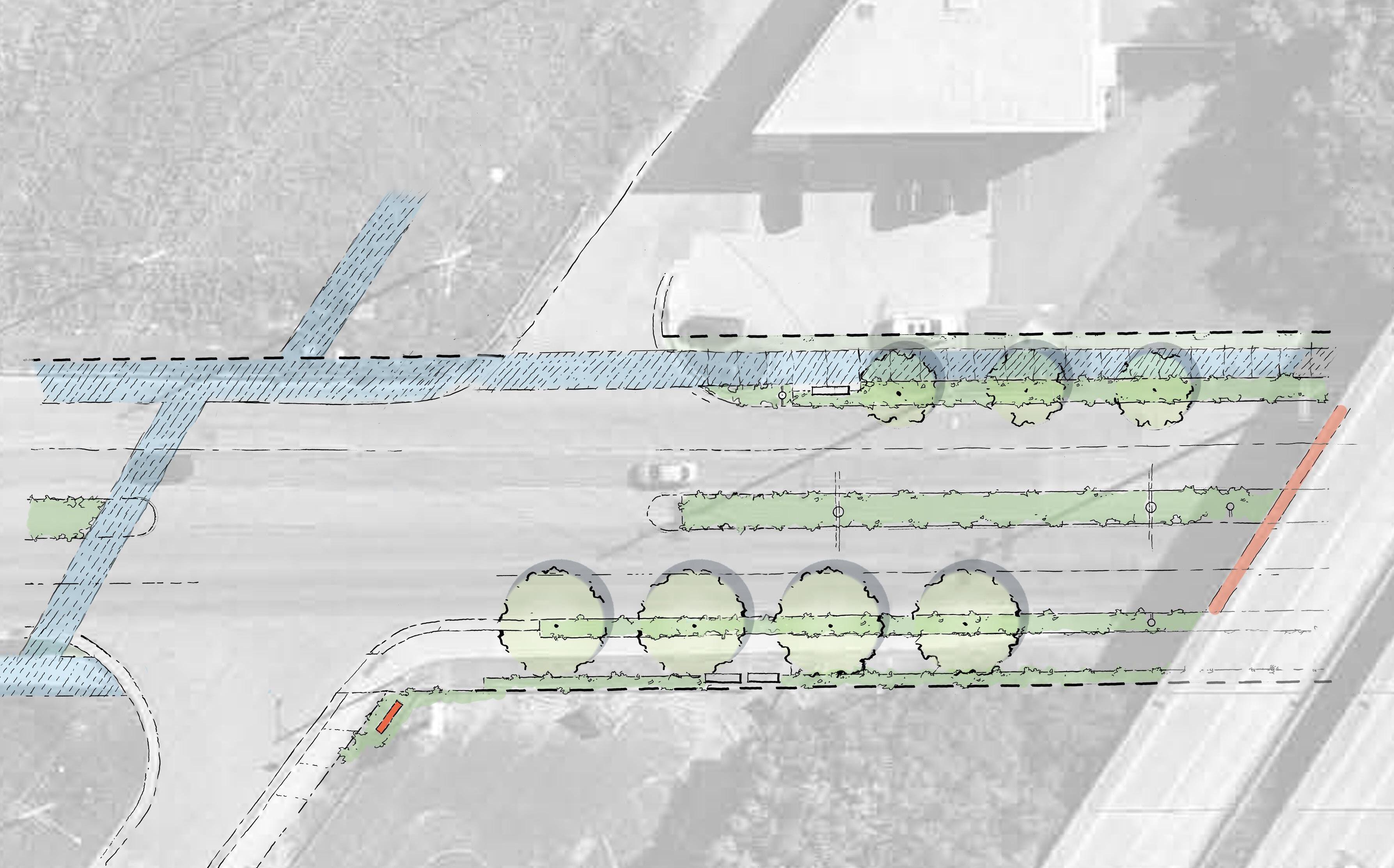
East Chicago • East Chicago Station 51 NORTH Existing Business NRoxanaDr I-90 Indianapolis Blvd 78’ ROW 8’ Walk Parklet with Seating Intersection Approach Signs Gateway Signage on Overpass 5’ Planting Area with Small Trees Minimum 8’ Multi-Use Path Planted Median & Turn Lane 6’ Planting Area with Street Trees NRoxanaDr I-90 Existing Business Indianapolis Blvd Existing 6’ Walk 86’ ROW PROPOSED 90’ ROW PROPOSED 4’ ROW Expansion 8’ ROW Expansion Existing ROW Existing ROW
Conceptual Sketch of Indianapolis Boulevard at North Roxana Drive Existing Conditions Potential Trail Extension
Indianapolis Boulevard at South Roxana Drive
Along with planned gateway enhancements on the I-90/Indiana Toll Road and South Shore Line overpass, cultural walls or lighting art installations are proposed below the overpass to create a more welcoming and safe pedestrian experiencing entering East Chicago. A right turn lane is removed to allow for a trail with a buffer between pedestrians and vehicles. This provides a continuous multi-use trail experience on the west side of Indianapolis Boulevard from the station to Kosciuszko Park.
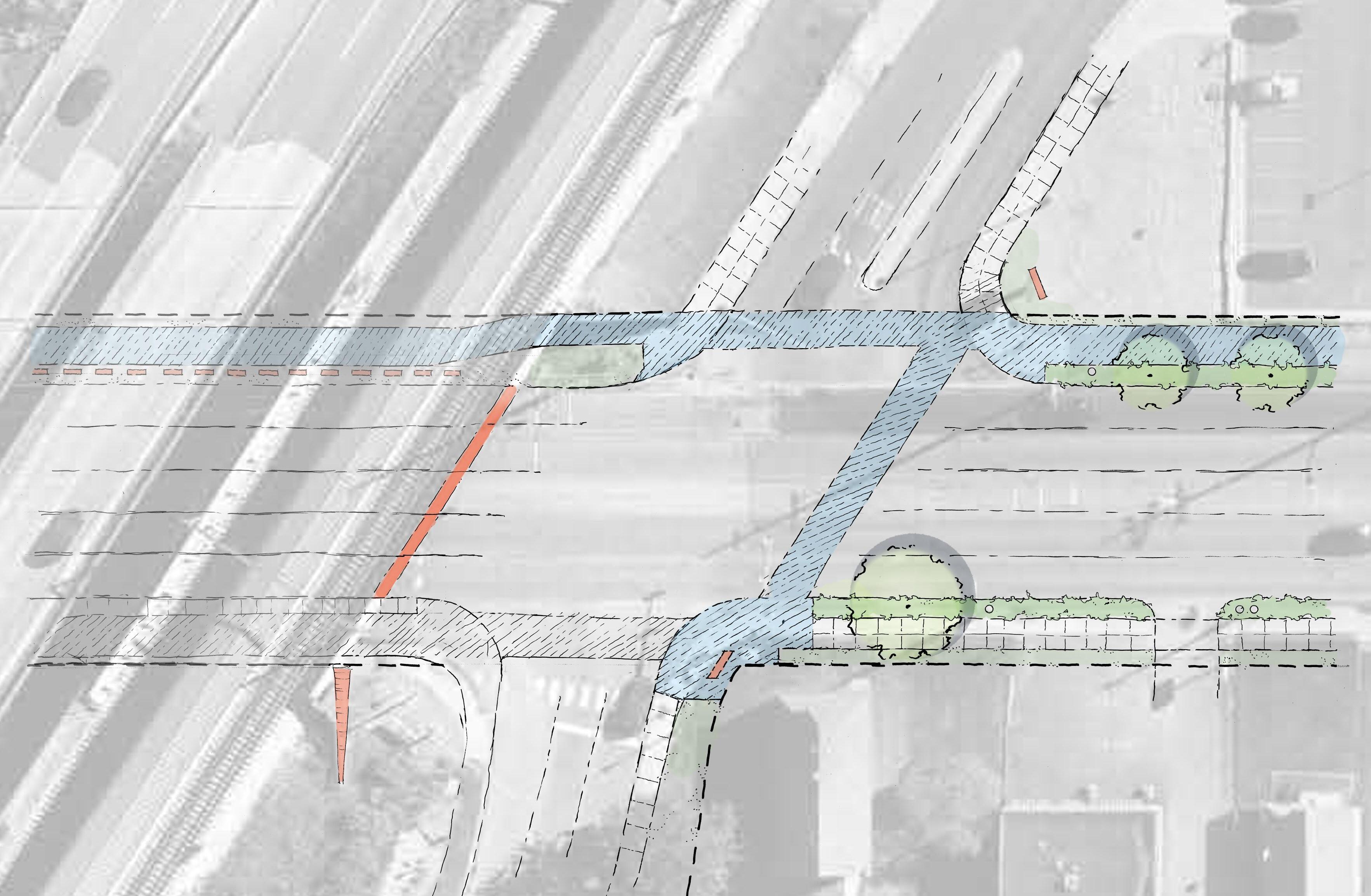
Northwest Indiana TDD • TOD Strategic Implementation Plan 52
Existing Businesses/ Residences NICTD Parking Indianapolis Blvd NORTH 78’ ROW StationEntrance S Roxana Dr South Shore Line I-90 8’ Walk Wayfinding Sign 5’ Planting Area with Small Trees Right Turn Lane Removed Gateway Signage on Overpass Plantings and Gateway Enhancement Buffer/ Public Art Feature Station Entrance Existing Lot Entry NICTD Parking (Enhance Landscape Edges) Indianapolis Blvd Existing Station Sign Existing Curb Existing Curb 90’ ROW PROPOSED Existing ROW Existing ROW Existing Traffic Signal Existing Walk 5’ to Building Front 34’ to Building Front Minimum 8’ Multi-Use Path Conceptual Sketch of Indianapolis Boulevard at South Roxana Drive Existing Conditions
Indianapolis Boulevard at Carrol Street
Preferred Concept
The City has installed a bollard buffer along the centerline on this segment of Indianapolis Boulevard to calm traffic and eliminate conflicting turns in and out of driveways. Proposed improvements would expand the right-of-way and relocate the curb on the west side to allow for a more substantial median. Expanding the right-of-way will require the City to engage in property acquisition. A 10-foot-wide multi-use path is proposed on the east side of the boulevard.
Street trees and a planted median along with placemaking elements would enhance the landscape of this otherwise unsightly corridor.
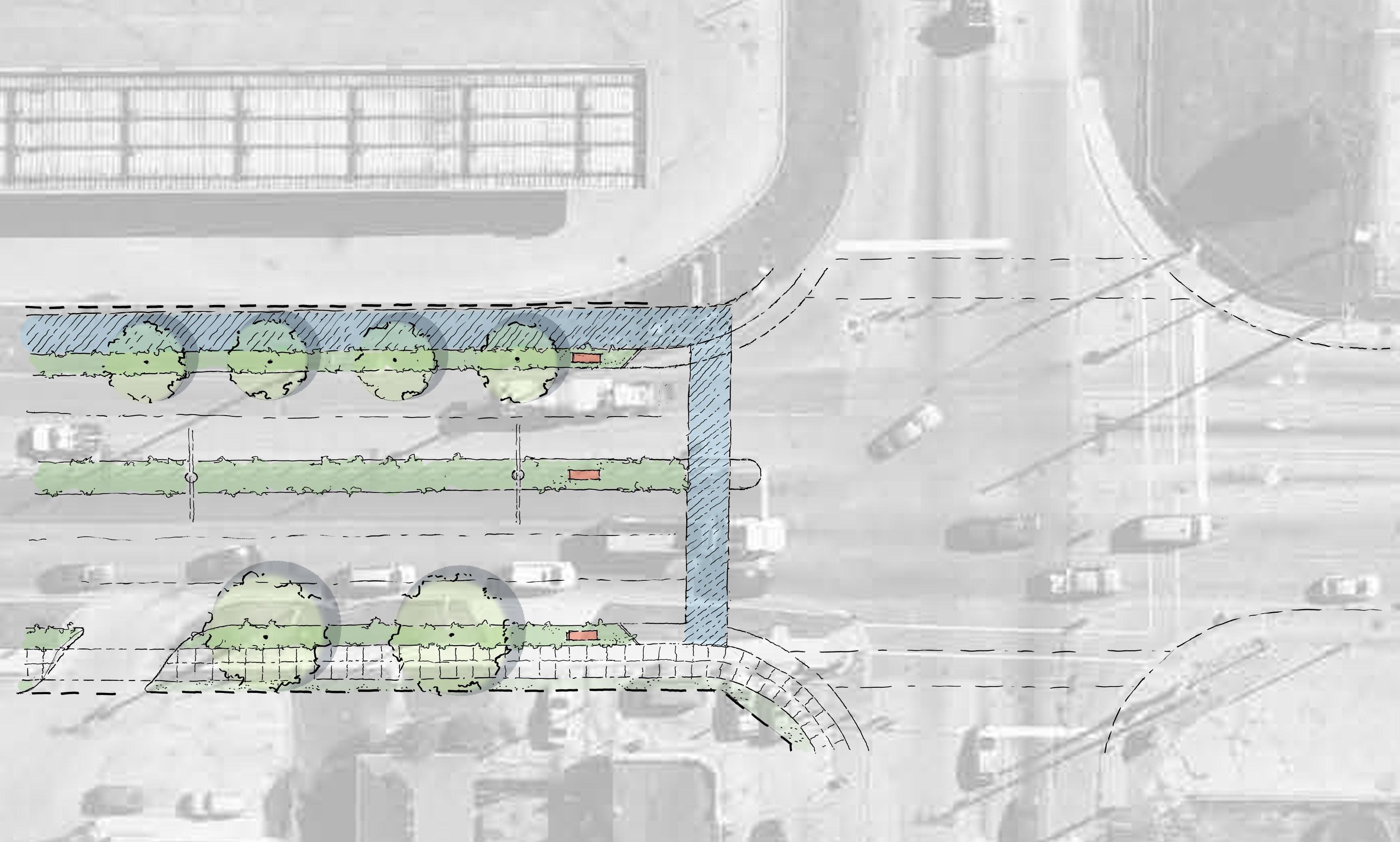
East Chicago • East Chicago Station 53 Conceptual
Indianapolis
Sketch of
Boulevard at Carrol Street, Preferred Concept
Existing Fueling Station Existing Buildings Indianapolis Blvd NORTH 78’ ROW Carrol St Carrol St City of Hammond Gateway Signage 8’ Walk Close Driveway 5’ Planting Area/ Street Trees Gateway Signage 10’ Multi-use Path Carrol St Existing Driveway Indianapolis Blvd Existing Curb 95’ ROW PROPOSED Existing ROW Existing ROW 5’ Planting Area with Small Trees City of Hammond Curb Aprons Safely Accommodate Trucks Enhanced Crosswalk & Adjusted Stop Bars * CONCEPT REQUIRES PROPERTY ACQUISITION Utility Pole Relocated Curb Shifts 8’ West Existing Conditions
Indianapolis Boulevard at Carrol Street
Alternative Concept
An alternative concept for this segment of Indianapolis Boulevard considers maintaining existing curbs and a smaller, more modest concrete median. Street trees and plantings as well as placemaking signage along the corridor will enhance the landscape. This concept also requires property acquisition to expand the right-of-way. A 10-foot-wide multi-use path is proposed on the east side of the corridor.
Indianapolis Blvd
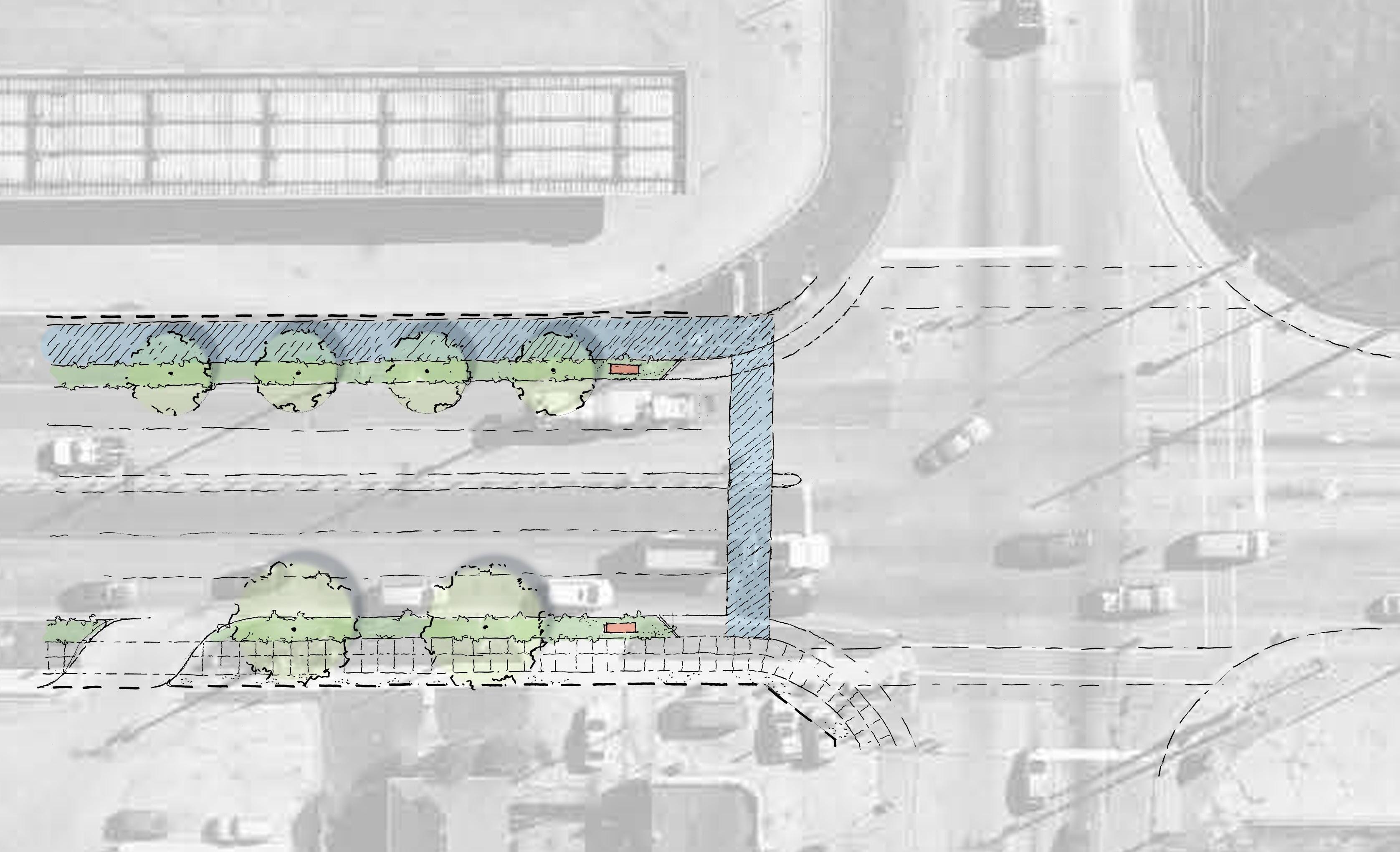
Northwest Indiana TDD • TOD Strategic Implementation Plan 54
Existing
Station Existing Buildings Indianapolis Blvd NORTH 78’ ROW Carrol St Carrol St City of Hammond Gateway Signage 8’ Walk Utility Pole Relocated Close Driveway 6’ Planting Area with Street Trees 10’ Multi-use Path Carrol St Existing Driveway
Fueling
Existing Curb Existing Curb 88’ ROW PROPOSED Existing ROW Existing ROW * CONCEPT REQUIRES PROPERTY ACQUISITION City of Hammond Gateway Signage 3’ Concrete Median 5’ Planting Area with Small Trees Curb Aprons Safely Accommodate Trucks Enhanced Crosswalk & Adjusted Stop Bars Existing Conditions Conceptual Sketch of Indianapolis Boulevard at Carrol Street, Alternative Concept
Indianapolis Boulevard Alternative Road Diet Concept
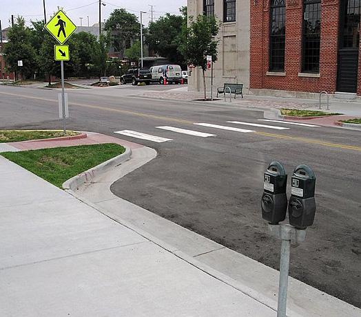
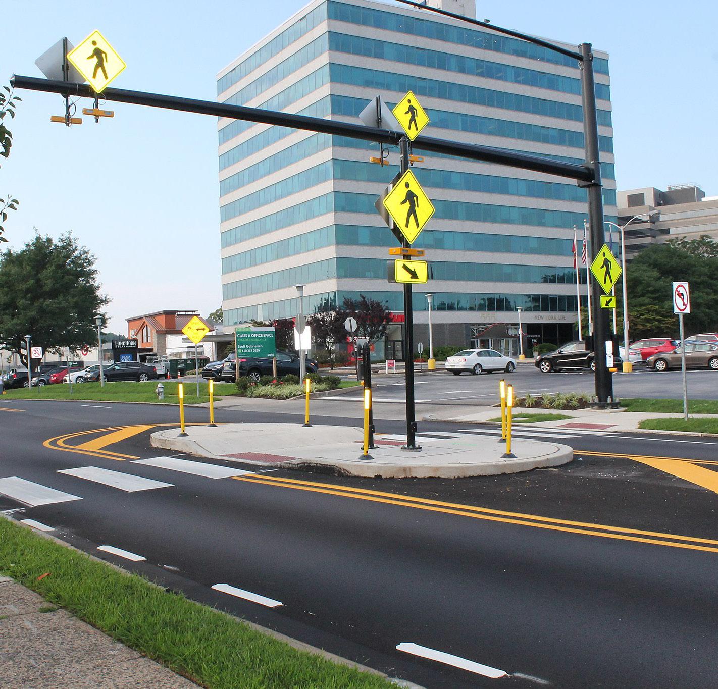
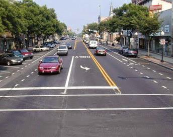
Another alternative to the concept envisioned on the preceding pages is to reimagine Indianapolis Boulevard as a complete street by implementing a ‘road diet.’ A road diet would reduce the number of vehicular travel lanes by one in each direction of travel and employ left turn lanes to facilitate a smooth flow of traffic despite the reduction in lanes. Implemented across the U.S., road diets have proven to improve safety across all modes of travel by calming vehicle speeds and improving facilities for pedestrians and cyclists.
A future road diet for Indianapolis Boulevard could build on the conceptual improvements shown on the preceding pages. The road diet cross-section of Indianapolis Boulevard would reduce vehicle lanes to two travel lanes- one in each directionand a left-turn lane. The left turn lane could become a planted median in stretches between intersections, and could serve as a pedestrian refuge at mid-block crossings. In addition to these reduced vehicle travel lanes, the boulevard could accommodate on-street parallel parking; on-street bike lanes; widened sidewalks; or widened tree lawns or landscaping to retain stormwater. The selection and configuration of these elements can be tailored to the discreet needs of the community and businesses along Indianapolis Boulevard and the greater network of bike/ped infrastructure
Existing passenger and freight traffic relying on Indianapolis Boulevard to connect interstate highways and local industrial sites proves a significant challenge to implementing this magnitude of change to the corridor. Projected traffic volumes should be further reviewed to evaluate the feasibility of implementing a road diet. The following images illustrate successful road diets that transform a vehicle-oriented thoroughfare into a safer, more walkable corridor.
East Chicago • East Chicago Station 55
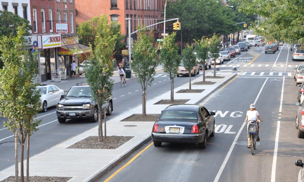
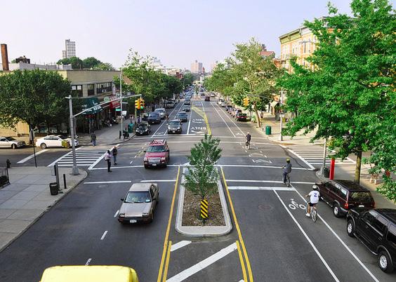
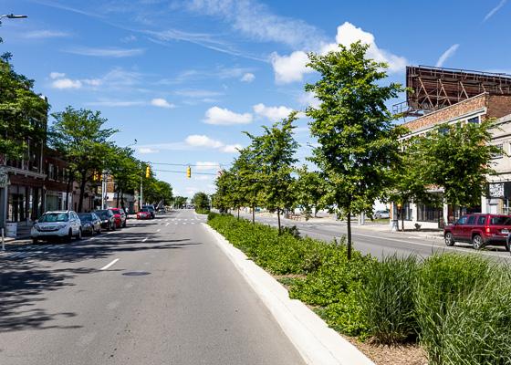
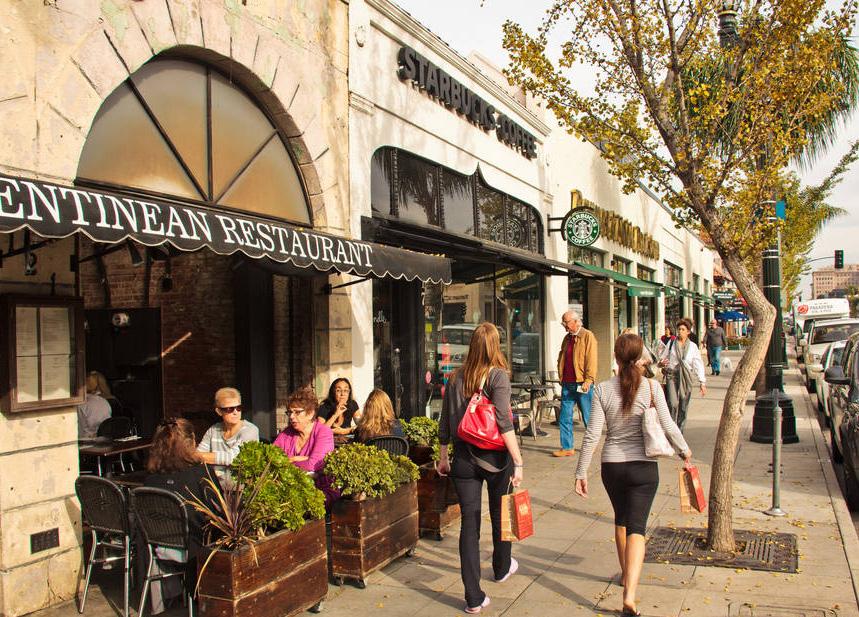
Northwest Indiana TDD • TOD Strategic Implementation Plan 56
Environmental Justice
Environmental Justice is defined by the US Environmental Protection Agency (EPA) as “the fair treatment and meaningful involvement of all people, regardless of race, color, national origin, or income, concerning the development, implementation, and enforcement of environmental laws, regulations, and policies.”
Given the large amount of industrial property, both active and inactive, in the City of East Chicagoparticularly near the river - there may be concern for adjacent residential areas, particularly in historically underserved neighborhoods. Two important environmental cleanup projects are currently underway in the City of East Chicago, the restoration of the Grand Calumet River and Roxana Marsh and the USS Lead Superfund site (which is not included in the TDD boundary). These projects illustrate the commitment by the City and the Northwest Indiana region to establish equity communities affected by legacy industry with Environmental Justice concerns.
More information on Environmental Justice can be found here: www.epa.gov/environmentaljustice
Roxana Marsh
The Roxana Marsh has seen substantial cleanup, with 600,000 cubic yards of contaminated sediment dredged and capped in the river and restored 19 acres of marsh habitat to date. This project was funded by the US EPA, US Fish and Wildlife Service, State of Indiana Department of Natural Resources (Indiana DNR), The Nature Conservancy, Save the Dunes, and the Shirley Heinze Land Trust. This cleanup project solidifies a legacy of renewed interest in the Grand Calumet River and important wildlife habitats. Restoration and enhancement of this river corridor and natural habitat can also serve the community as a natural amenity. Any nearby development should be conducted sensitively to reduce or mitigate negative impacts to the river and the marsh. The City should continue supporting plans for conservation-focused low-impact development with trail access.
More information on the Roxana Marsh cleanup can be found here: www.greatlakesmud.org/roxana-marsh--grand-calumet-river-aoc.html
Superfund Sites
The former USS Lead Superfund site includes the USS Lead facility along with nearby commercial, municipal and residential areas. It was listed on the National Priorities List of the worst contaminated sites in the country in 2009.
It is important to note that East Chicago’s TOD area and TDD boundary do not include the USS Lead Superfund site, or areas of contamination and corresponding cleanup. While it is not anticipated that any brownfield issues may result from these nearby areas due to the historic industrial nature of this area, additional environmental due diligence should occur before any residential development occurs in this portion of East Chicago. This study can be used as a screening report to assist in identifying known issues, but there may be unknown issues throughout this study area.
More information on the USS Lead Superfund site can be found here: https://www.epa.gov/uss-lead-superfundsite
East Chicago • East Chicago Station 57
Zoning
Coding Objectives
The team worked with City staff to identify coding objectives, review the current code for the ability to achieve TOD, and prepare draft code language that the City of East Chicago can review and locally adopt following this planning process. The team recorded current zoning within the TDD boundary and relevant recommendations from previous plans. The East Chicago’s current zoning code requires an update to prepare the community for TOD. The team has prepared an evaluation of the current code and a new coding template. Due to the detail and length of the coding template, detailed zoning recommendations are in the Appendix.
The zoning ordinance dated 1998 but amended subsequently is an older style text ordinance that does not contemplate TOD in the vicinity of the East Chicago area or the redevelopment of the corridors within the TDD boundary. This code permits heavy industry along Indianapolis Boulevard, which the City no longer wants in the area. Instead, the City wants to attract logistics, warehouses, and light manufacturing uses to a few large sites and focus on improving this key gateway into the city with diverse, community-serving development such as a residential and neighborhood commercial mix.
Existing Zoning Districts
The table below lists the existing Zoning Districts within the boundary of the TDD area, along with their description.
District Description
R-1a Single-family or Semi-detached Dwelling district
R-2 Two-Family Dwelling District
R-3 Multiple Dwelling and/ or Two-Story Row House District
R-4 Multiple Dwelling, 3 story or less District
May include one-family dwellings; two-family semi-detached dwellings (two homes built side-by-side that share a common wall); parks/open space; and accessory buildings
May include one-family dwellings; two-family dwellings (two-family dwellings that do not fit the ‘semi-detached’ definition, such as a two-flat with the units stacked on top of one another); and boarding houses and lodging houses
May include one-family dwellings; two-family dwellings; two-story rowhouses (3+ dwelling units with common walls between adjacent units); two-story multi-family dwellings; group dwellings; and boardinghouses and lodging houses
May include 1-family dwellings, 2-family dwellings; 2-story rowhouses; 2-story multi-familyily dwellings; group dwellings; multi family dwellings; multi family group dwellings; hospitals and clinics; dormitories; clubs and lodges; apartment hotels; hotel restaurants/drugstores; boardinghouses and lodging houses; and accessory buildings
C-1 Neighborhood Retail District Purpose is to provide convenience retail and services to adjacent residential neighborhoods; located sporadically throughout most of East Chicago’s neighborhoods, C1 is usually a small, one-half or one-block segment
C-2 General Commercial District Purpose is to provide for a greater intensity and wider range of commercial uses than those found in C1, and may be associated with a “Central Business District”
P-1 Park District
Designed to protect established park and recreational lands; location corresponds to existing municipal parks
M-1 Light Industrial District Purpose is to provide locations for light manufacturing and industrial uses
M-2 Heavy Industrial District Purpose is to provide a location for heavy manufacturing and industry
East Chicago • East Chicago Station 59
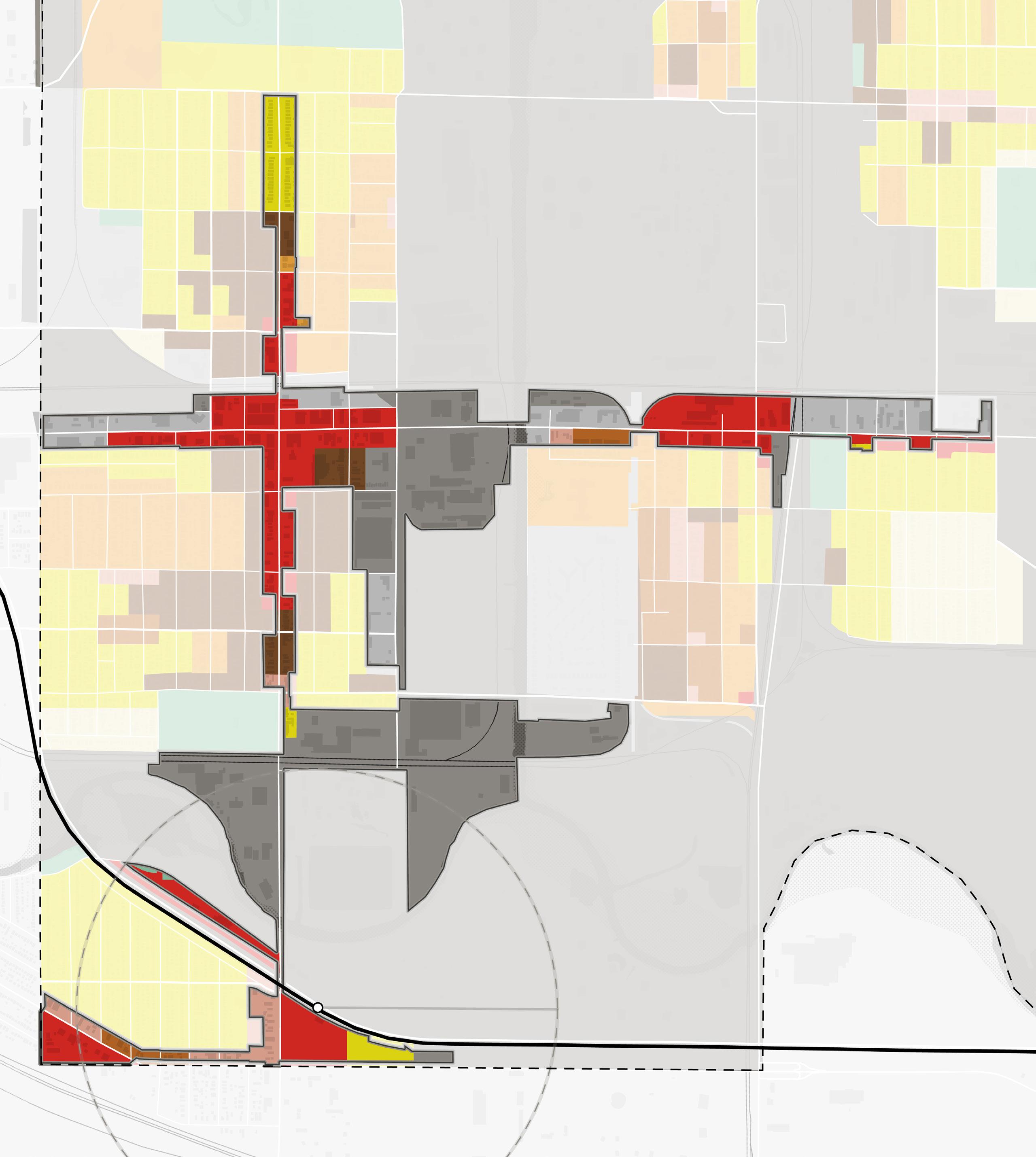
Northwest Indiana TDD • TOD Strategic Implementation Plan 60 R1 R1a R2 R3 R4 C1 C2 C3 M1 M2 P1
C1 C1 C1 C1 C2 C2 C2 C2 C2 C2 C2 C2 C2 R1a R1a R1a R1a R2 R2 R3 R3 R4 R4 R4 M1 M1 M1 M1 M1 M2 M2 M2 M2 M2 M2 M2 NORTH Riley Park 90 South Shore Line East Chicago Station Kennedy Ave Euclid Ave 145th St 148th St Kennedy Ave Carrol St Kosciuszko Park City Hall and Veterans Park Marino/ WARE Manufacturing Facility Roxana Marsh Roxana Park and Recreation Center 1/2 Mile EAST CHICAGO HAMMOND Corporate Limits EAST CHICAGO HAMMOND Corporate Limits GrandCalumet River 151st St 150th St W Columbus Dr White Oak Ave Railroad Ave Indianapolis Blvd Chicago Ave
Existing Zoning Districts
Existing Zoning Metrics
Some of the primary metrics that were taken into account in the analysis are provided in the table.
unless 40% or more of the frontage on the same side of the street between 2 buildings that have observed a front yard line having a variation in depth of not more than 10 ft, in which case no building shall project beyond the average front yard so established
except where lot width is 40 ft or less, side yard may be min of 10% of width but no less than 3 ft; on corner lot: 8 ft, but buildable width of lot shall not be less than 26 ft
unless the lot has depth of less than 100 ft, then depth shall not be less than 20% of depth
R-3 2.5 stories or 35 ft 4500 sq ft (single-family); 2000 sq ft (two-family or semi-detached); 1500 sq ft (2 story rowhouse, 2 story multiple dwelling or group dwelling)
R-4 3 stories or 35 ft 4500 sq ft (single-family); 2000 sq ft (two-family or semi-detached); 1500 sq ft (2 story rowhouse or 2 story group dwelling) or 2 story group dwelling); 700 sq ft (3 story multiple dwelling structure or family group dwelling
Same as R-1a, except on lots w/ less than 100 ft depth where 2 story row houses are erected perpendicular to the front line, in which case the front yard may be decreased to 20% of the lot depth but never less than 20 ft
35 ft Same as R-3 for single-family, two-family and 2 story rowhouse; 20 ft for multiple dwelling structure or multi family group dwelling
Same as R-1a for single and two-family;- for 2 story multi-familyily or rowhouse: 10 ft; where lot is used for group dwellings: 10 ft
Same as R-1 for single and two-family; for 2 story multi-familyily, group, or rowhouse: same as R-3; for 3 story multi-familyily: 20 ft
Same as R-1a
Same as side setback
C-1 2 stories or 35 ft
N/A No yard required, except where a C-1 district abuts a residence district along a street line, there shall be provided, for a distance of 50 ft from district boundary line into such C-1 district, a front yard equal to .5 of the required front yd depth for such residence district
No yard required, except that abuts directly a res: 6 ft; on corner lot which borders res district: shall be equal in depth to required front yard on such side street
No yard required, except that abuts directly a res: 6 ft C-2 6 stories or 75 ft
M-1 Any height not in conflict w/ other provisions of title or other city ordinances /regs
N/A
N/A Where a front yard abuts or adjoins a residence district at street line and building is to exceed 6 stories or 75 ft, min front yard shall be increased by at least 1 ft for each 3 ft of height in excess of 75 ft
10 ft where adjoining a residence district Abutting or adjoining a res district and bldg > 6 stories/75 ft: 1 ft for each 3 ft of bldg height over 75 ft
M-2 Same as M-1 N/A
N/A Where all frontage on 1 side of street between 2 intersecting streets is not located in an M2, none required; also in M2 where such district adjoins a res/com/M1 district, without separation by a street, front yard shall be same as adjoining district for either remainder of frontage on that street w/ in same block or for distance of no less than 500 ft, whichever is lesser
0 ft where lot adjoins another M2 district; in all other cases: same as M1
0 ft where lot adjoins another M2 district; in all other cases: same as M1
East Chicago • East Chicago Station 61
District Height (max) Min. Lot Area Min. Lot Width Min. Front Setback Min. Side Setback Min. Rear Setback R-1a 2.5 stories or 35 ft 4500 sq ft 37.5 ft 25 ft;
5 ft;
30 ft;
R-2 2.5 stories
35
4500
37.5 ft Same
R-1a Same
Same
R-1a
or
ft
sq ft
as
as R-1a
as
35 ft
N/A
N/A N/A
P-1 N/A N/A N/A N/A
See C-1 See C-1 See C-1
N/A N/A
Codes and Recommendations
The 2016 Roxana TOD Plan provides recommendations for intensity, urban form, and character and documents the current conditions for two neighborhoods (Roxana and Southside) within the TDD boundary. Based on the desire to become compact, walkable, pedestrian-friendly, dense, connected, mixed-use, and accessible we recommended small setbacks, higher building intensity, and 80% maximum lot coverage. The Roxana TOD Plan calls for a TOD Overlay for the area, but we recommend adopting the calibrated template and regulating plan as the base zoning for the area since there currently isn’t an appropriate base zoning district that would implement the vision. The height intensity of 3-4 stories referenced in the Roxana TOD Plan is utilized as the height maximum in the calibrated template. The calibrated template also includes a light industrial/maker/artisan district that will provide a transition from single-family to heavier industrial. The industrial zone metrics were also calibrated using the Roxana TOD Plan and are intended to create a higher-quality urban form.
TOD Principles Evaluation Recommendation
Industrial Repositioning
Corridor
The area along the Harbor Canal is currently zoned Heavy Industrial.
The Indianapolis Corridor is zoned a mix of C-1, C-2, R-1a, R-4, and M-2. These zoning districts do allow for a mix of residential, commercial and industrial uses, but the uses that fall within the zoning districts and where they fall on the map don’t align with some of the goals for this area, as noted in the Roxana TOD Plan. The C-2 zoning allows wholesale storage and warehouses, auto parking lots, used car lots, auto show rooms, and repair. The M-2 heavy industrial area separates the station area from the mixed-use area north on Indianapolis Blvd.
Look at rezoning some of the heavy industrial zoning to a new light industrial district that would allow for some employment/maker/artisan uses.
New zoning districts should be created for the corridor to implement the mix and intensity of uses that are envisioned for the area. New zoning districts should include light industrial/maker districts that provide transitions from single-family to heavier industrial.
Mixed-Use Town Center
The Roxana TOD Plan envisions a mixed-use center around the neighborhood, while preserving the existing single-family character. This area is zoned C-1 and R-3 which are the most appropriate of the current zoning districts, but due to some metrics, such as height, they may not fully implement the vision.
Parking The current zoning doesn’t have shared parking regulations or TOD parking reductions. It does allow for off-site parking, but only with BZA approval.
New zoning districts should be created for a neighborhood center abutting the stable single-family development in the Roxana neighborhood.
New parking regulations should be developed to allow for shared parking, off-site parking and TOD parking reductions.
Northwest Indiana TDD • TOD Strategic Implementation Plan 62
Proposed Zoning Districts
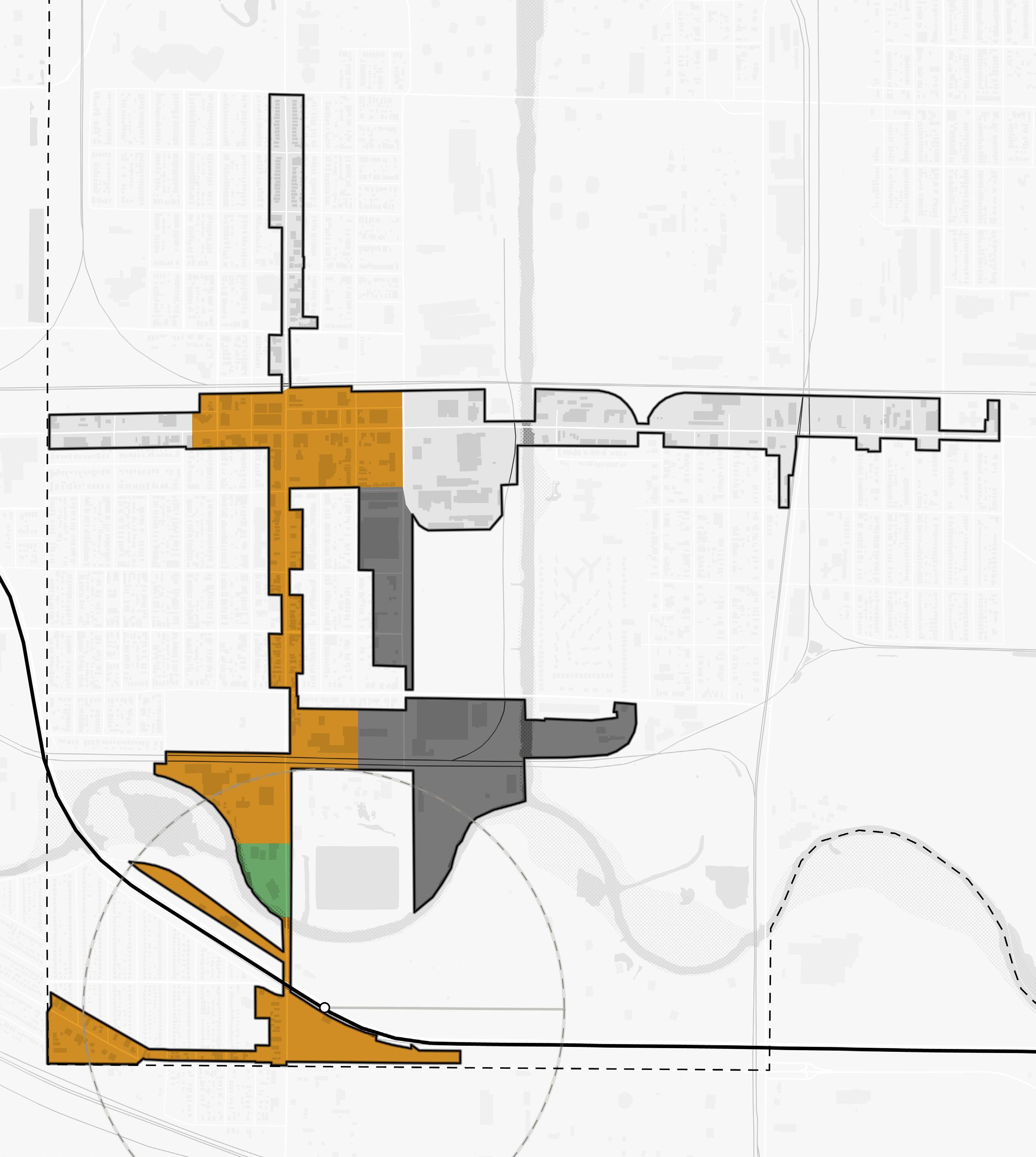
East Chicago • East Chicago Station 63 CD-4 CD-4M CV CD-4 CD-4 CD-4 CD-4M CV NORTH Euclid Ave Chicago Ave Railroad Ave Indianapolis Blvd 90 Roxana Park and Recreation Center Carrol St East Chicago Station 1/2 Mile South Shore Line EAST CHICAGO HAMMOND Corporate Limits Kennedy Ave GrandCalumet River 151st St 150th St Kosciuszko Park Roxana Marsh White Oak Ave EAST CHICAGO HAMMOND Corporate Limits City Hall and Veterans Park 145th St W Columbus Dr Riley Park 148th St Kennedy Ave Marino/ WARE Manufacturing Facility
Implementation
Implementation Strategies
While planning efforts are inherently long-range in scope, there is a benefit to identifying early projects – catalyst projects – that are necessary to improve market conditions and spark changes. This is where a development plan becomes more tangible with near-term goals that can be brought into sharper focus for the community and achieved relatively quickly to create momentum into the future.
Critical components of an implementable development plan include site capacity, economic viability, and political support. The implementation strategy summarizes project recommendations contained within this plan and an explanation of associated infrastructure project costs that can be used to develop a capital projects plan that supports TOD. This process is aimed at providing implementable steps and technical resources for the community to advance and adopt in preparation for TOD in accordance with its growth path.
Implementation strategies are outlined in three timeframes and are defined below: Immediate Next Steps, Short-Term Strategies, and Long-Term Strategies.
Immediate Next Steps
Actions to take quickly to get recommendations set up for implementation
Short-Term Strategies
Tasks and projects that can be executed in a 1-5 year timeframe
Long-Term Strategies
Tasks and projects that require additional work to execute and can be completed in 5 or more years
Enabling Actions
• Host an educational session “road show” with the Northwest Indiana RDA inviting elected and appointed officials and residents to discuss the impacts of land use decisions within the TDD boundary and the potential impacts of TOD on population, employment, and economic growth
• Collaborate with the RDA to understand how projects could be funded through TDD increment dollars as revenue begins to flow into the TDD fund in 2024
• Meet with City of East Chicago staff to review TOD and zoning recommendations. Develop a responsibility matrix.
• Use recommendations and illustrations within this plan funding requests/applications for NIRPC, READI, Next Level Trails, and other state, federal, and philanthropic grant opportunities
Recommendations
Land Use & Zoning
Immediate Next Steps
• Create a working group of City staff and Plan Commission members to review the recommendations within this plan. Evaluate the potential of adopting this plan as an area plan to guide land use and development in this area as part of the City’s Comprehensive Plan.
• Review the zoning recommendations and calibrated zoning template included in this plan. Bring this draft information to the working group to further evaluate the next steps of updating the City’s Zoning Ordinance.
Short-Term Strategies
• Begin the process of updating the Comprehensive Plan, incorporating the East Chicago TOD Implementation Strategy by reference. Conduct a public process to vet the recommendations and make desired changes. Adopt land use recommendations in this plan as an update to the City’s Comprehensive Plan Maps.
Northwest Indiana TDD • TOD Strategic Implementation Plan 64
• Begin the necessary legal review process and make updates to the City’s Zoning Ordinance to incorporate the calibrated code template as an overlay or rezoned districts. Conduct a public process to vet the recommendations and make desired changes. Adopt new code language and regulating plan into the Zoning Ordinance.
Long-Term Strategies
• Begin development using updated land use and zoning to help elevate the development quality and improve the experience for petitioners seeking to do projects in the city
(Re)development
Immediate Next Steps
• Create a working group of City staff and Redevelopment Commission members to review the East Chicago TOD Implementation Strategy and educate members on how the TDD can help enable the City’s desire for transitand trail-oriented development near the East Chicago Station and Roxana Neighborhood and along Indianapolis Boulevard connecting to the Marquette Greenway
• Reach out to developers who participated in the RDA TDD Industry Day to showcase opportunity sites. Understand the development community’s willingness to partner with the City as a developer in the overall TOD strategy.
• Reach out to property owners on identified opportunity sites to understand their willingness to participate in a TOD revitalization strategy and redevelopment
Short-Term Strategies
• Meet with the Knights of Columbus to discuss the property on Indianapolis Boulevard/North Roxana Drive and participation in a revitalization strategy centered around transit- and trail-oriented development and enhancements to the Grand Calumet River and Roxana Marsh
• Collaborate with the Parks Board, Public Library, Roxana Community Center, and the Roxana Neighborhood to discuss the development opportunity along Indianapolis Boulevard between South Roxana Drive and Michigan/Carrol Streets and the potential integration of these uses/ services and shared parking scenarios
• Convene follow-up conversations with developers to understand the willingness to work with the City in a Public-Private Partnership on City-owned property at Roxana Park
• Explore the potential to acquire and assemble properties for development, either through the TDD, existing TIF, a potential future development corporation or 501(c)(6), or in collaboration with a market-rate or tax credit developer
• Begin assembling property outside of the 100-year floodplain along the Grand Calumet River and Roxana Marsh
• Reference the brownfield analysis included in the Appendix when discussing redevelopment on sites within the TDD boundary
• Use the Arc of Development study to advance conversations with the community and other major stakeholders about the potential for revitalization tied to TOD, including population growth, job creation, and economic development through TDD revenue
• Promote sustainable design through adaptive re-use or the use of local, durable and/or recycled building materials, permeable pavement, electric charging stations and solar panels, shared parking strategies, and native plant species
Long-Term Strategies
• Leverage potential Complete Streets and trail investments along Indianapolis Boulevard as part of a neighborhood revitalization strategy focused on mobility and access to transit and trails
• Engage the development community to target opportunity sites for land acquisition and assemblage either by the City or a private developer and advance development concepts
• Develop a mixed-income neighborhood with a variety of residential products, prices, and amenities that will serve the needs of a dynamic, growing TOD district
• Manage land uses to transition property between the Marquette Greenway and the station from industrial to mixed-use and residential
• Work with NICTD to identify interest in joint development strategies for mixed-use development, replacing a portion of the East Chicago Station surface lot
• Collaborate with the City of Hammond to redevelop heavy industrial sites south of the East Chicago Station, if the sites ever become available
• Work with IDEM and EPA to monitor the progress of cleanup sites and understand the timeframes for future development, what limitations may remain after cleanup, and what further steps need to be taken to enable desired development on these sites
East Chicago • East Chicago Station 65
Thoroughfare Improvements
Immediate Next Steps
• Facilitate conversation among the City, INDOT, NIRPC, and NICTD to discuss potential Complete Streets improvements to Indianapolis Boulevard (US 20) from Carrol/Michigan Streets to 152nd Street. Discuss pedestrian and vehicular safety improvements such as enhanced pedestrian amenities, trail connections, intersection controls, and streetscape beautification
Short-Term Strategies
• Coordinate streetscape and sidewalk improvements with identified routes and trail connections, such as repairing sidewalks in disrepair or widening narrow pathways, constructing new pathways and sidewalks, and enhancing crosswalks.
• Address the I-90/Indiana Toll Road and South Shore Line underpass concerning traffic control, safety, and walkability. Explore opportunities for gateway signage and public art/placemaking to serve as a gateway into East Chicago and make the underpass more attractive.
• Identify where right-of-way acquisition needs to occur along Indianapolis Boulevard and any utilities that need to be relocated (if any) to enable streetscape improvements
Long-Term Strategies
• Continue working with INDOT to advance street design concepts to improve this segment Indianapolis Boulevard. Acquire additional right-of-way on the east side of Indianapolis Boulevard for streetscape enhancements and on the west side for utility relocation and streetscape enhancement to support future redevelopment.
• Partner with NICTD to make streetscape improvements to the NICTD lots frontage along Indianapolis Boulevard frontage, including enhanced sidewalks, street trees, and streetlights
• Consider an alternative truck route to alleviate a percentage of truck traffic from Indianapolis Boulevard (US 20) as industrial uses along the corridor reduce over time
• Construct Complete Streets projects identified in this study. Coordinate with INDOT on other potential improvement projects affecting state routes/INDOT jurisdictional roads and with INDOT and NICTD on improvements to the I-90/Indiana Toll Road and South Shore Line underpass.
Capital Improvements
Immediate Next Steps
• Work with NIRPC to get the proposed Complete Streets improvements identified in this TOD strategy into the Transportation Improvement Plan (TIP) for implementation funding
Short-Term Strategies
• Partner with INDOT and NIRPC on funding a connection from the Marquette Greenway to the East Chicago station
• Coordinate with INDOT on funding Complete Street improvements identified in this plan on the portion of Indianapolis Boulevard
Transportation & Mobility
Immediate Next Steps
• Conduct a sidewalk and greenway conditions assessment to determine where improvements are needed to connect to the East Chicago Station
• Continue to discuss with NIRPC alignment/ connections from the Marquette Greenway to the East Chicago Station and neighborhoods
Short-Term Strategies
• Support first- and last-mile connections to the station, such as upgraded sidewalks, ADA ramps, and bike/scooter share programs
• Identify a strategy to make connections to the Marquette Greenway. Focus on improving pedestrian conditions along existing roadways where the trail alignment will cross roadways and linking the trail to the station, trailheads, major destinations, and existing neighborhoods.
Northwest Indiana TDD • TOD Strategic Implementation Plan 66
Community Building & Identity
Immediate Next Steps
• Brand the area from the East Chicago Station north on Indianapolis Boulevard as a transit-oriented and trail-oriented development district
• Continue to invest in streetscape and gateway improvements (including the mural recently installed on the I-90/South Shore Line bridge over Indianapolis Boulevard)
• Partner with Knights of Columbus to activate the area adjacent to Roxana Marsh with family-friendly programming and engage with the community on further enhancement opportunities
• Employ an Equitable Development Toolkit to model impactful and inclusive growth on catalytic sites. Prioritize support for projects which:
› Convene enhanced outreach to minority and non-English speaking populations within the community
› Incorporate bilingual wayfinding signage throughout the district
› Support mixed-income and workforcefocused development
› Establish a framework for preventing displacement
› Create pathways to community wealth-building
› Invest in the public realm and promote the development of an authentic identity
› Support the growth of a thriving minorityowned business community and startups
East Chicago • East Chicago Station 67
Capital Improvements Plan
Capital project planning is integrated into preparing plans, conducting planning activities, and advancing development planning at TOD Opportunity sites. Required upgrades to utilities, streets, and public realm streetscapes were studied as part of this project as they are necessary to support TOD in these communities. As these infrastructure needs were identified, capital improvement plans were created and tailored to each station area. These charts include an estimated cost range for conceptual designs to guide decision-making, funding allocation, and eventual implementation.
Segment Calculated Cost Estimated Cost Range 152nd St. Intersection $656,900 $591,200 - $722,600 152nd St. to N. Roxana Dr. Corridor $2,548,100 $2,293,300 - $2,803,000 N. Roxana Dr. Intersection $214,200 $192,700 - $235,600 N. Roxana Dr. to S. Roxana Dr. Corridor $640,800 $576,700 - $704,900 S. Roxana Dr. Intersection $695,500 $625,900 - $765,000 S. Roxana Dr. to Carrol St. Corridor $1,107,500 $996,700 - $1,218,200 Carrol St. Intersection $605,500 $545,000 - $667,000 Total Costs $4,060,100 $3,655,100 - $4,467,000
Northwest Indiana TDD • TOD Strategic Implementation Plan 68
Indianapolis Boulevard Improvements Cost Estimate
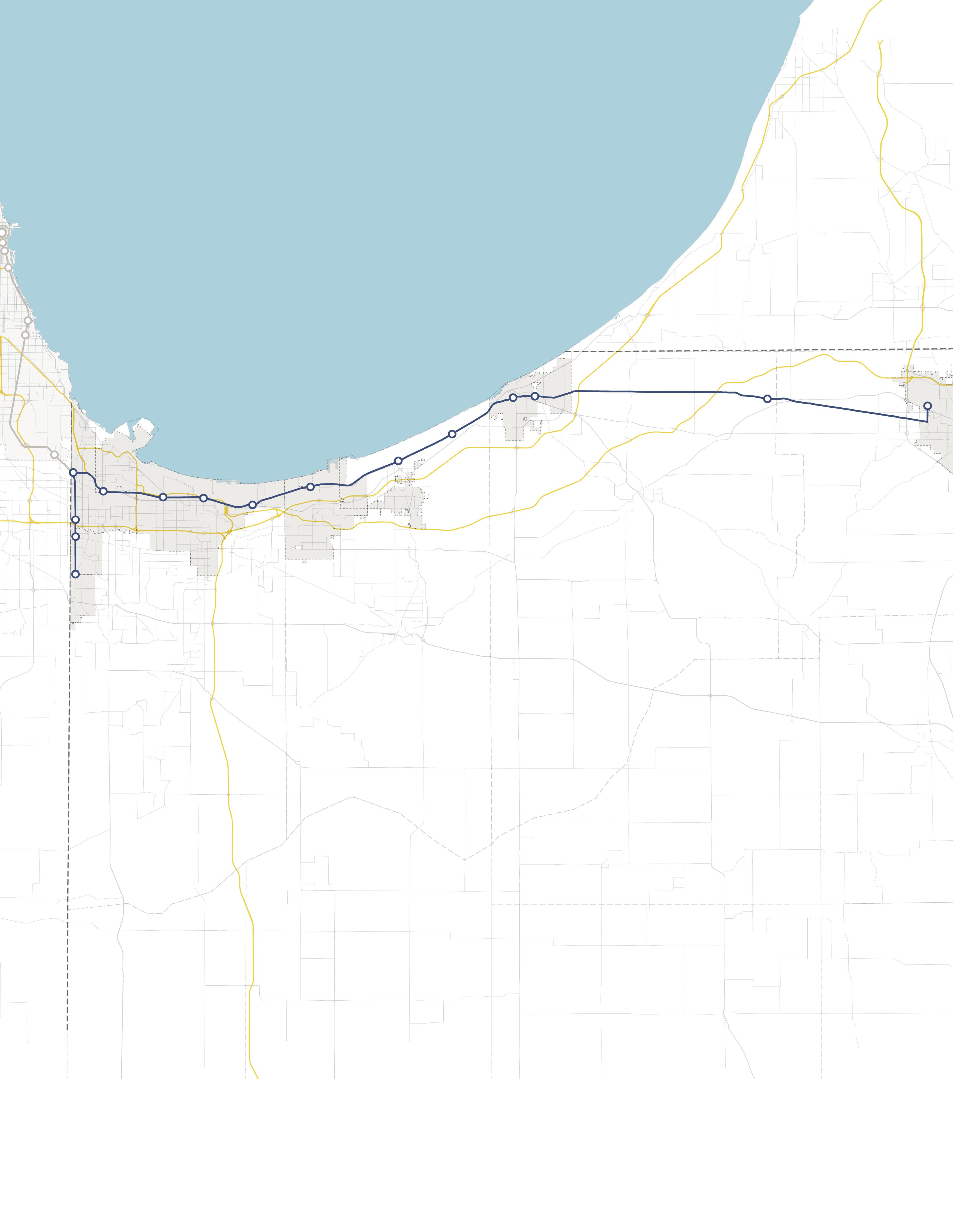

INDIANA INDIANA MICHIGAN ILLINOIS 94 94 80 65 Lake Michigan Hammond Gateway East Chicago Gary Metro Center Miller Portage/ Ogden Dunes 11th Street South Bend Dune Park Beverly Shores Ridge Road Main Street
