


A station area with a high concentration of vacant or underutilized land and the addition of the West Lake Corridor could see new opportunities for mixed-use, infill, and employment development.
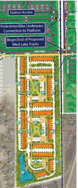
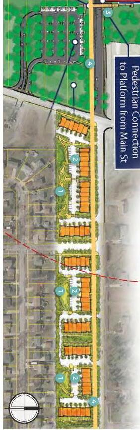
The Munster/Dyer Main Street TDD is unique to the West Lake Corridor because it is located within two municipalities and is separated by Main Street. This area demonstrates tremendous greenfield development opportunities, both directly around the station and on the Columbia Avenue and Sheffield Avenue corridors. The new station and parking area could transition to joint development over time. Much of the remaining developable sites in Munster and Dyer are situated within this TDD and are largely consolidated amongst a few non-residential owners. Both towns have been proactive in preparing for this station and anticipated investment in the vicinity, and they are working to determine the next steps to extend Main Street to Joe Orr Road in Illinois. Munster recently updated its characterbased zoning code and up-zoned some properties near the station. Dyer recently updated its comprehensive plan and commenced a project to update its zoning code to enable TOD development near the station.
• Promote sustainable growthconcentrate at strategic redevelopment areas
• Support transit as critical to a prosperous town
• Create a legacy of unique parks and open spaces
• Grow as a hub of regional trail systems
• Strengthen infrastructure to meet future needs
• Redevelop old areas as walkable, mixed use centers
• Strengthen Dyer’s identity as a livable and a family friendly “home town”
• Create a new walkable downtown core
• Capture the economic potential of the new train station along Main Street
• Transform Sheffield Avenue into a vibrant multi-modal street
• Maximize economic development potential along Calumet Avenue
• Invest in long-term redevelopment of US 30
• Prioritize investments in creating a connected trail system
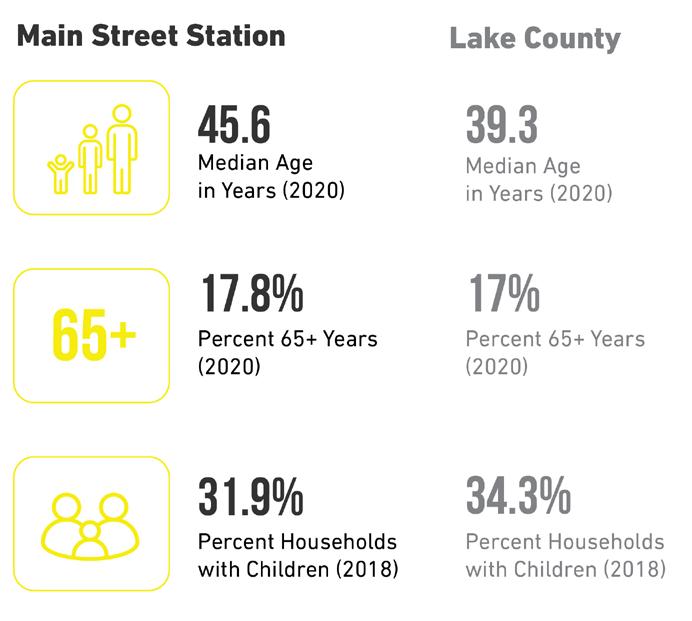
Station Area | County Comparison
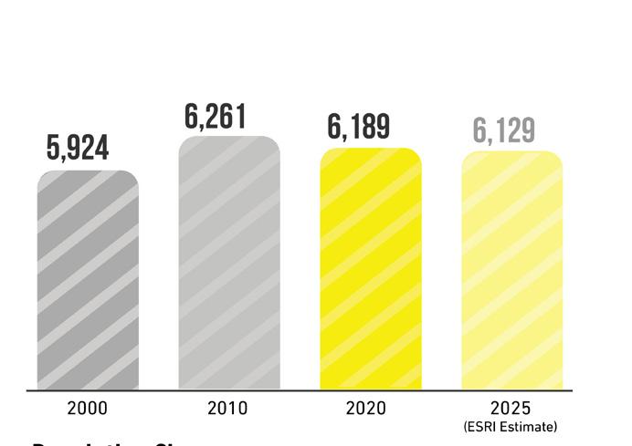
Population Change

Relevant Planning: RDA TDD boundaries (ongoing), Dyer Comprehensive Plan (2020), Munster Character-Based Zoning Code(2019), West Lake TOD Plan (2017), NWIN RDA Comprehensive Strategic Plan (2016), and Munster Comprehensive Plan (2010).
Zoning Ordinance Overview:
Munster: The 2019 Munster Character-based Zoning Code is a hybrid form-based approach that allows for the appropriate mixing of uses and development densities to support TOD. Parking regulations are also favorable to enabling the density the community wants to see in this area. The area around the station has been zoned to the highest density classification, however additional zoning language may be needed to accommodate missing middle housing, and to encourage mixed-use and multi-family development further east of the station. Missing middle housing may help alleviate restrictions on ground floor uses and density in this area. Minor changes to this code may be required to balance desired (re)development with the preservation of single-family areas. A large amount of property owned by the Community Foundation east of Columbia Avenue that has ample opportunity to be developed as a walkable TOD.
Dyer: The Town of Dyer recently adopted a new comprehensive plan and is currently undergoing a zoning code rewrite with a focus on limited mixed-use, townhome/rowhouse, and multi-family development near the station and along Sheffield Avenue. Current code drafts will need to be reviewed to ensure the proposed code supports TOD development.
Public Engagement: To kick off the study of the Main Street TDD station area, a community bus tour and leadership work session was held in May 2019. An “On-Your-Own Gallery” made information available to the public to access and review throughout November and December 2020. In December 2020, a virtual public engagement session was held via Zoom video conferencing and Facebook Live/YouTube, and 117 community members attended the session. Materials from this engagement session were also posted to the project website.
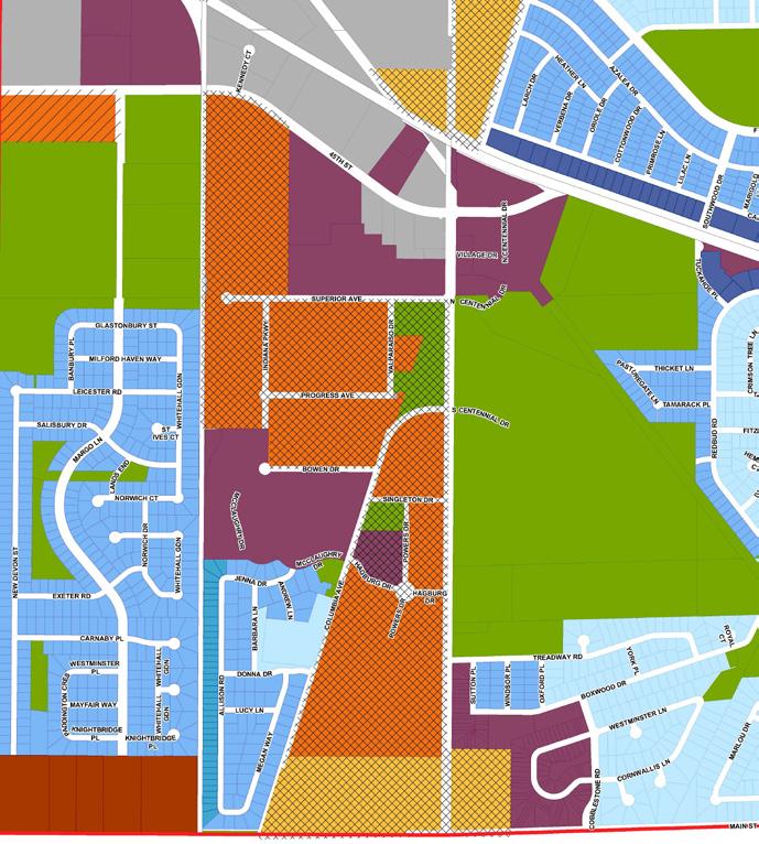
CD-5 - Urban Center
CD-4A - General Urban A
CD-4B - General Urban B
CD-4-R4 - Multi-family Residential
CD-3-R3 - 60’ Lot One Family and Two Family
CD-3-R2 - 60’ Lot One Family Residence
CD-3-R1 - 70’ Lot One Family Residence
Civic - Civic Zone
SD-M - Special District - Manufacturing
Livable Munster Character Based Code (2019)
1 2 3
 Town of Dyer Comprehensive Plan (2020)
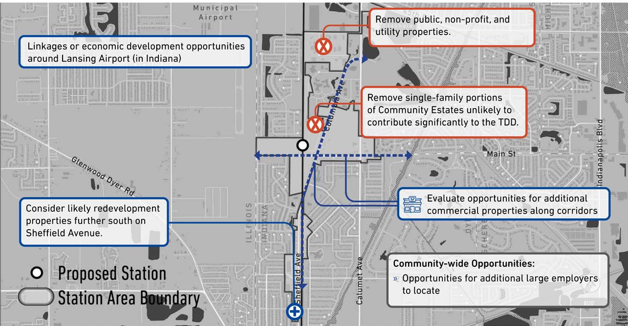
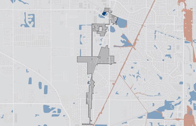
The analysis required for creating the boundary focused on floodplains and flood zones; land use patterns, including community anchors (destinations such as schools, parks, city halls, churches, etc.), commercial areas and corridors, residential neighborhoods near these places of activity, agricultural or preserved land, industrial land, and vacant or underutilized and publicly-owned land; TIF Districts and Opportunity Zone boundaries; and previous planned areas or other areas of interest identified by the municipalities. Locating land uses and destinations in the station area provides a sense of where generators of economic activity, community gathering, and employment opportunities currently exist in the community. Locating vacant or underutilized and publicly-owned land and other areas of interest helps identify sites that may have a low barrier to redevelopment or have already been considered for redevelopment by the municipalities and suggest where future development and investment could occur.
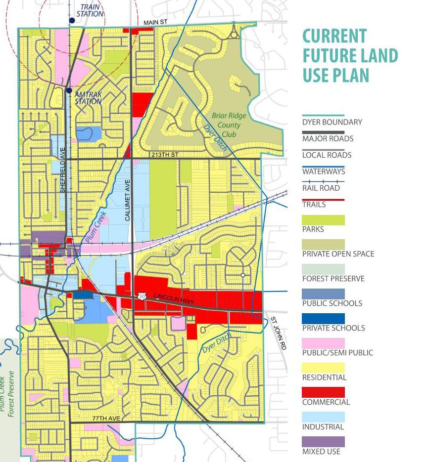
Existing land use patterns can inform opportunities for future investment that is compatible and complementary for the community. North of the station in Munster, Centennial Village is a notable commercial destination as well as the intersection of Calumet Avenue and Main Street. The Main Street station area is surrounded by residential, most of which is in the form of single-family housing in a disconnected subdivision-like pattern. Major community anchors for these communities include several parks, a golf course, and an Amtrak Station on Sheffield Avenue in Dyer. However, it is noted that these anchors do not fall within the TDD boundary. South of the proposed station in Dyer, Sheffield Avenue is a major commercial corridor.
There is a high concentration of vacant or underutilized land around the proposed station and Main Street. This availability of developable sites immediately adjacent to the Main Street station could more quickly enable TOD development to accompany the station and rail line.
Areas of interest that were identified to consider for development include the partially completed residential development on Main Street near Columbia Avenue, Progress Business Park to the north of the station, and Centennial Village. Previously planned areas include the portions of the Sheffield Avenue corridor and the Main Street corridor as identified in the Dyer Comprehensive Plan, as well as sites adjacent to the proposed station that could include medium-density residential and parking for the station.
Due Diligence: Floodplain
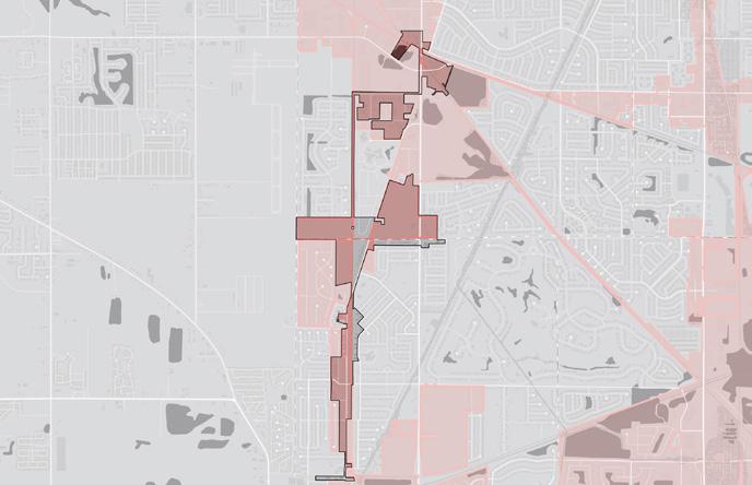
Due Diligence: TIF District
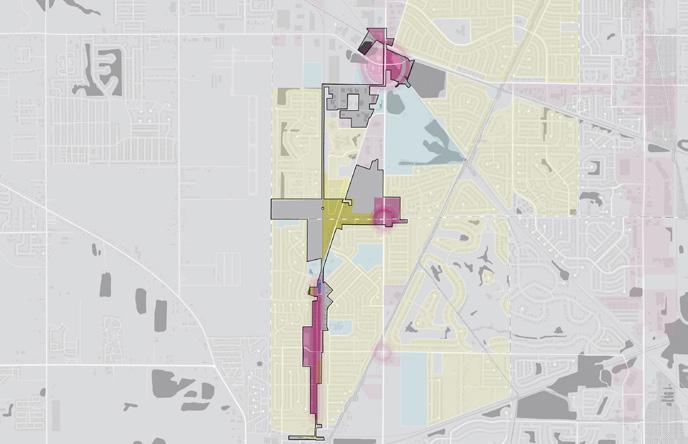
Land Use: Community Anchors, Commercial, and Residential
Vacant and Publicly-owned
City Plans and Areas of Interest
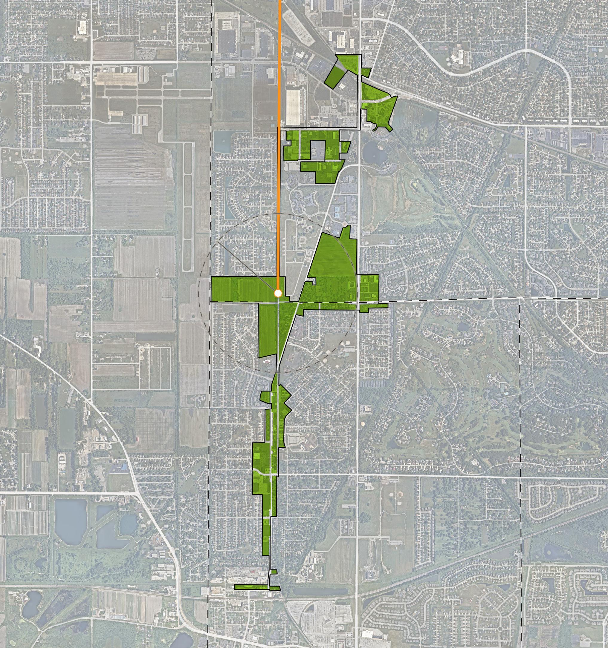
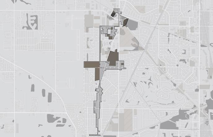
TOTAL ACRES: 302.4 ACRES
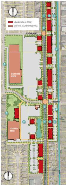
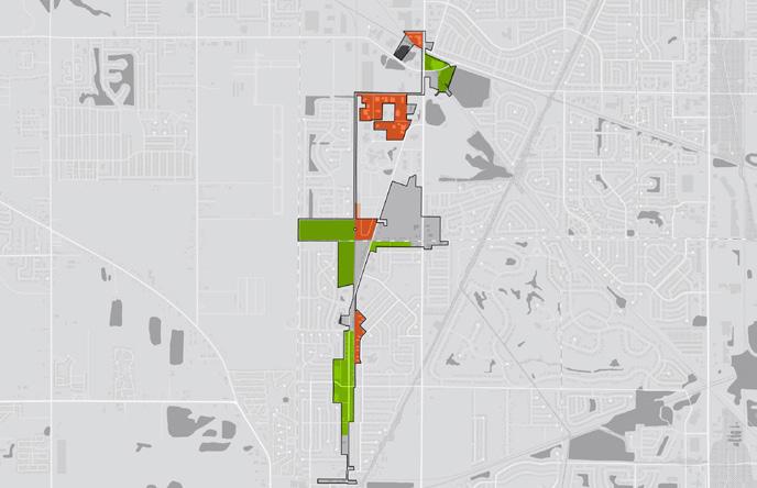
The resulting TDD boundary for the Munster/Dyer Main Street TDD station area focuses on three future investment strategies: Mixed-Use Town Center, Neighborhoods, and Employment Center. Due to the station area’s proposed location at the crossroads of two major corridors, mixed-use development could anchor this station area. A variety of residential types and scales would help transition between the higher density mixed-use core of the TDD and the surrounding existing neighborhoods. An employment center for Munster and Dyer could help market these communities as advantageous locations to attract businesses and create jobs.
NEIGHBORHOODS
MIXED-USE TOWN CENTER EMPLOYMENT CENTER