
February 2023 Warrigal Drive, Westleigh Prepared under the provisions of the Local Government Act, 1993 Parks and Recreation Team, Hornsby Shire Council Westleigh
Park
Draft Plan of Management
HORNSBY SHIRE COUNCIL
ABN 20 706 996 972
CONTACT DETAILS:
In Person: The Administration Centre Peats Ferry Road
Hornsby NSW 2077
Email: hsc@hornsby.nsw.gov.au
Telephone: 9847 6666
Write: PO Box 37, Hornsby, NSW 1630
Online: hornsby.nsw.gov.au
Customer service desks are open from 8.30am5pm business days
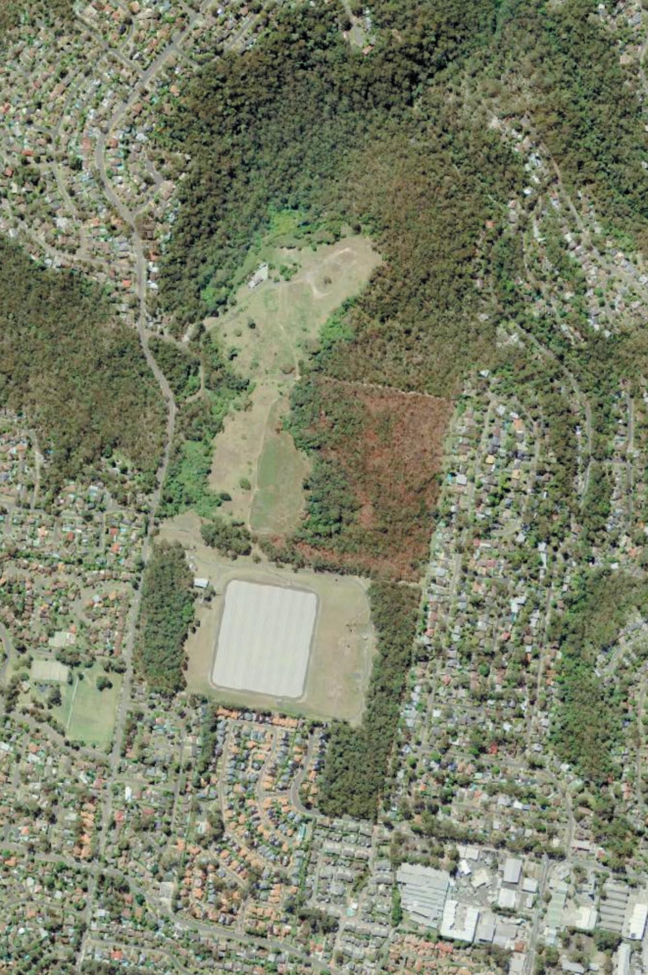
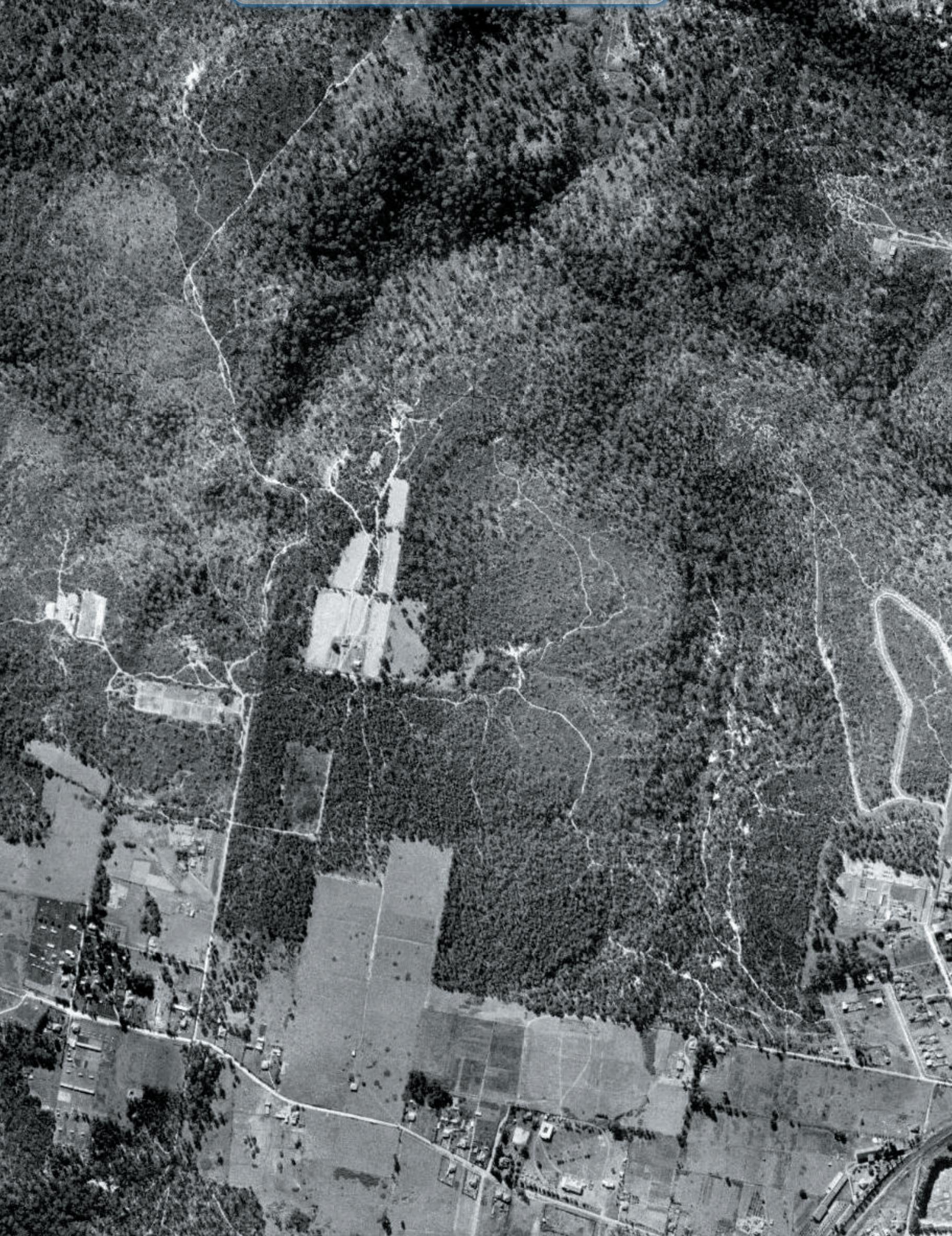
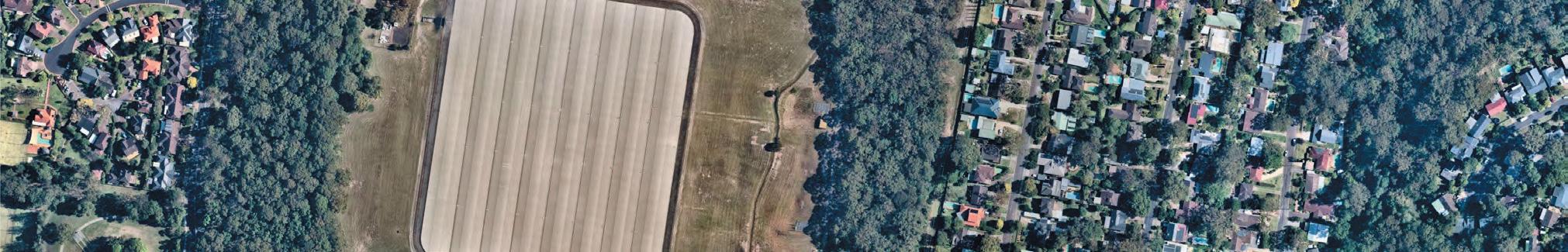
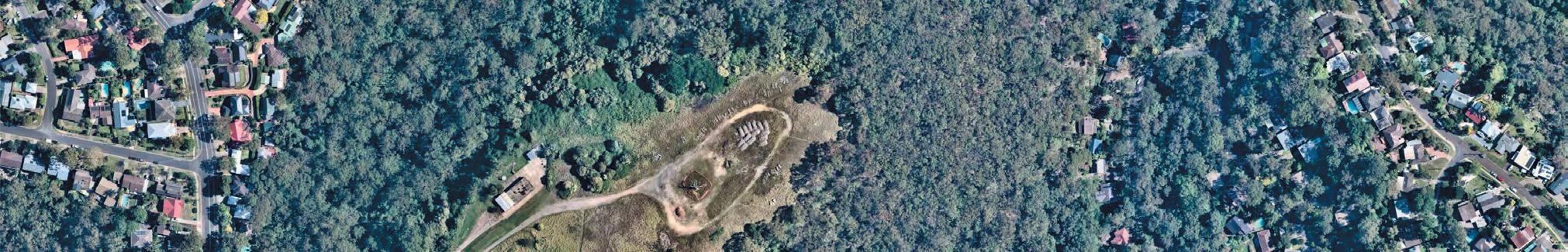
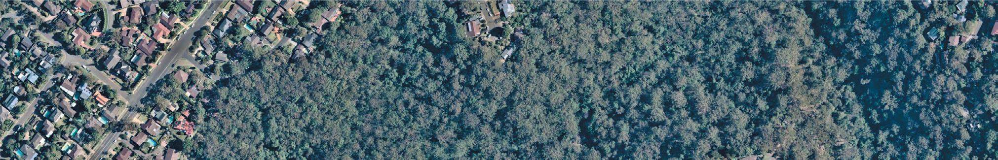
View North over Westleigh (Source GOOGLE EARTH)
2
PLAN OF MANAGEMENT
This Plan has been prepared to comply with the Local Government Amendment (Community Land Management) Regulations and associated amendments to the Local Government Act 1993 (LG Act), section 42 (LG Act), which commenced on 1st January 1999.
COMMUNITY INPUT INTO THE PLAN OF MANAGEMENT
Section 38 of the LG Act requires that all Plans of Management covering community land are placed on public display for a minimum period of 28 days. A minimum period of 42 days after the draft is placed on exhibition is allowed for written submissions to be made to Council.
Submissions allow the community (including residents, interest groups, sporting clubs and government agencies) to provide information, suggest alternatives and express opinions in relation to the proposed management of community lands within Hornsby Shire.
After consideration of all submissions received, Council may decide to amend the draft plan of management, or adopt it without amendment. If Council decides to amend the draft plan, it must publicly exhibit the amendments in accordance with the requirements of section 40 of the LG Act.
A Public Hearing is required to be held in respect of a draft Plan of Management (PoM) only if the proposed Plan would have the effect of categorising or re-categorising the community land in accordance with section 40A of the LG Act.
Council recognises the Traditional Owners of the lands of Hornsby Shire, the Darug and GuriNgai peoples, and pays respect to their Ancestors and Elders past and present and to their Heritage. We acknowledge and uphold their intrinsic connections and continuing relationships to Country.
WESTLEIGH PARK – DRAFT PLAN OF MANAGEMENT February 2023 3
foreword
4
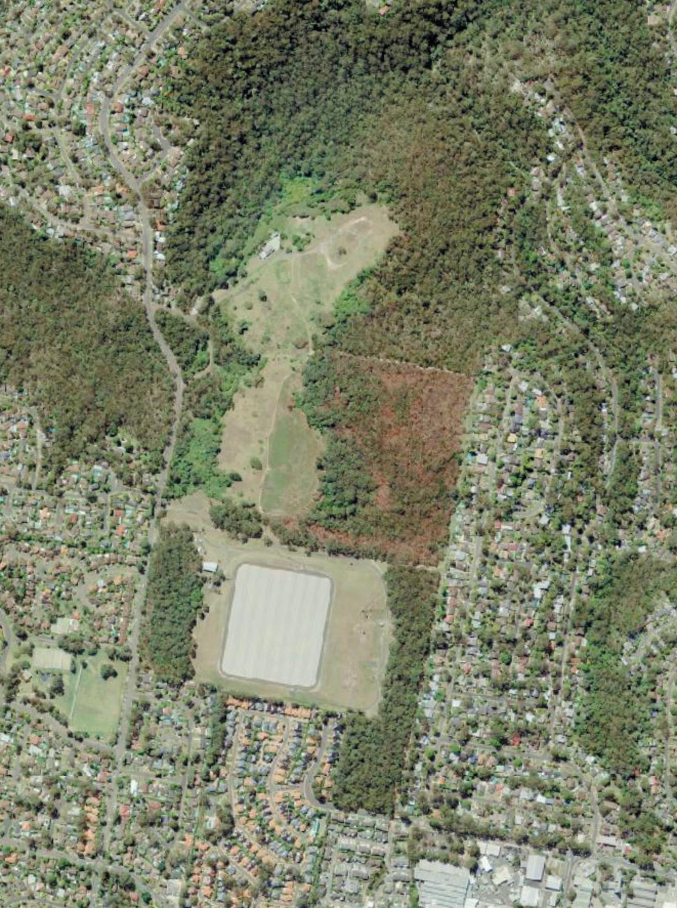
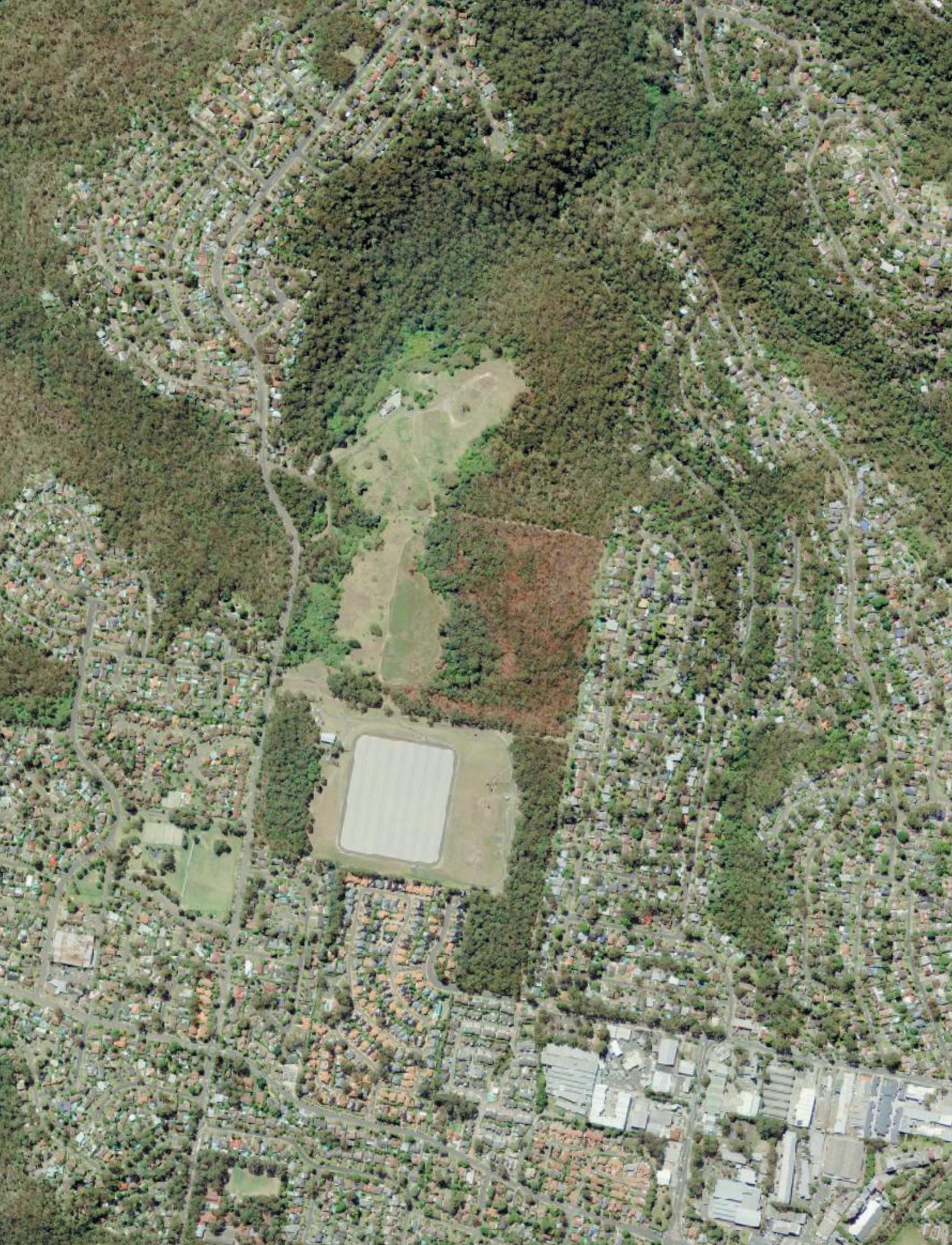
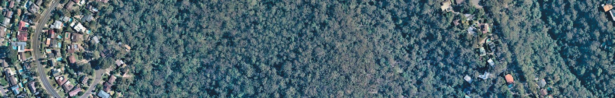
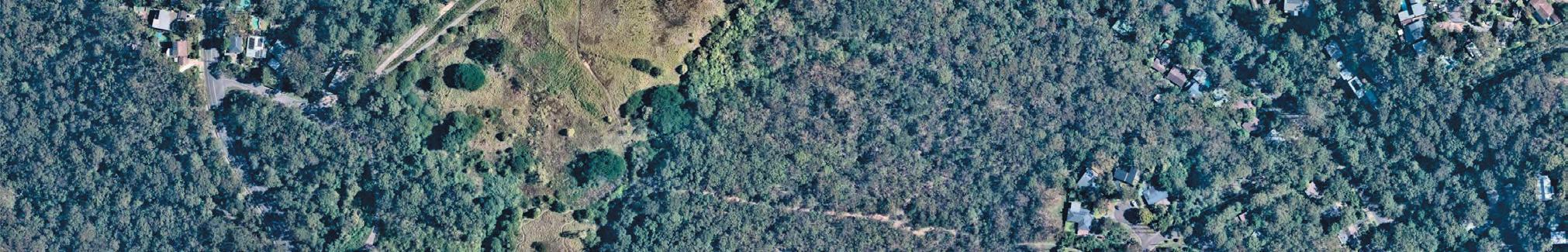
View North across Westleigh Park site (source: Environmental Partnership)
WESTLEIGH PARK – DRAFT PLAN OF MANAGEMENT February 2023 5 contents Forward Part 1 1.0 Introduction 7 2.0 Local Government Act Requirements 8 3.0 Site Description 10 4.0 Master Plan Development 26 5.0 Land Categorisation 40 6.0 Operational Proposals 42 Part 2 7.0 Action Plan 49 8.0 Action Plan for all Categories of Community Land 50 9.0 Action Plan for Parks and Natural Area - Bushland 61 10.0 Action Plan for Areas of General Community Use 76 11.0 Action Plan for Parks and Sportsgrounds 91 12.0 Appendix 94 Appendix 1: Park Rules Notice
6
View North into Westleigh Park from southern boundary (source: Environmental Partnership)
Part 1
1.0 Introduction
1.1 What is a Plan of Management ?
A Plan of Management (PoM) is a document that provides a means to control the future use, development and maintenance of Community Land under Council’s care, control and management. This PoM will identify issues relevant to the future management of Westleigh Park, including the accommodation of various proposed and existing features of the site. The PoM will establish Council’s goals, strategies and desired outcomes that will guide the timing, shape and nature of developments.
This PoM is presented in the following two parts to allow review of individual parts as required:
Part 1 of the PoM includes core objectives for the community land categories as determined by the LG Act, 1993, and Council’s management goals. This part looks at issues relevant to Westleigh Park to determine broad objectives for management.
Part 2 titled Action Plan outlines strategies for how the objectives will be achieved and actions necessary to fulfil the strategies. This part of the PoM also outlines the standards for Council’s levels of service and identifies the manner in which Council will assess its performance in relation to achieving goals.
The Action Plan is the working section of the document and will require amendment as actions are completed. The Action Plan is proposed to be relevant for a period of five to ten years. The Action Plan may be revised from time to time, in response to changing community needs and aspirations.
1.2 Why Prepare a Plan of Management for Westleigh Park?
Westleigh Park was acquired by Hornsby Shire Council (Council) in 2016 from Sydney Water. The land comprises a central cleared zone zoned R2 residential, which has been subject to a variety of past uses including landfill. This cleared zone adjoins areas of remnant and regenerating bushland on all sides which includes an area of E3 (Environmental Management) zoning. The land was acquired with the purpose of addressing multiple objectives, including:
remediation of the past developed and landfill zone
provision of recreational facilities
conservation and management of bushland areas
A series of investigations were undertaken to review the requirements for remediation of the site which examined a number of options for remediation and earthworks.
In 2018, Council undertook a concept design study which identified potential site arrangements for park and recreational facilities and a related approach to site remediation and earthworks.
In order to facilitate the implementation of the park proposals, this specific PoM will document proposed park use, community land categorisations and other general LG Act requirements. This plan excludes the small island of Crown Land adjoining Warrigal Drive which is outside of the proposed works area.
This PoM is supported by a Master Plan which has been developed for the site, accompanied by recommendations for the staged implementation of proposals for the various park elements. This PoM has been prepared in accordance with and seeks adoption under the LG Act The preparation of this PoM is intended to represent the culmination of Council’s investigations aimed at determining an appropriate character and scale for the development and management for Westleigh Park. The preparation of this PoM also enables Council to strategically address recreation needs in a staged manner. It will enable commencement of the development of new open space facilities at Westleigh Park, and will help identify a program of development and ongoing maintenance works.
1.3 What Development is Allowable under the Plan of Management?
A PoM must define the existing and future uses of community land as required under the Local Government Act, 1993. Future uses and development proposed for Westleigh Park are outlined in Sections 5.0 and 6.0 of this plan. As Council considers necessary, development allowable under this PoM may include:
Provision of sports fields, courts, and associated parking, access roads and amenities buildings;
Provision of grandstands and sporting seating;
Provision of retaining walls and site drainage
Provision of playgrounds (in accordance with Council’s adopted Hornsby Play Plan 2019);
Provision of facilities ancillary to existing use including seating, picnic and barbeque facilities, shelters, lighting, field drainage and irrigation, fencing, pathways, and new signage.
Provision of community facilities
If there is any further development of the community land other than that authorised by this PoM, or a change in the categorisation of Westleigh Park is proposed, amendment and re-exhibition of the PoM is required.
WESTLEIGH PARK – DRAFT PLAN OF MANAGEMENT February 2023 7
2.0 Local Government Act Requirements
2.1 Classification and Categorisation
Westleigh Park comprises land classified as community land in accordance with Chapter 6, Part 2, Division 1 of the Local Government Act (LG Act), 1993.
2.2 Core Objectives
Community Land must be categorised in accordance with the LG Act. The category reflects the physical character and use of the lands. Each category is supported by Guidelines for Categorisation in the LG Act. The categories include:
• General Community Use
• Park
• Sportsground
• Area of Cultural Significance
• Natural Area, which has sub-categories as below:
- Bushland
- Wetland
- Watercourse
- Foreshore
- Escarpment
The LG Act also establishes core objectives for all categories of community land. The significance of the prescribed core objectives is to ensure that any activities or uses of the land are consistent with the core objectives for the prescribed land categorisation.
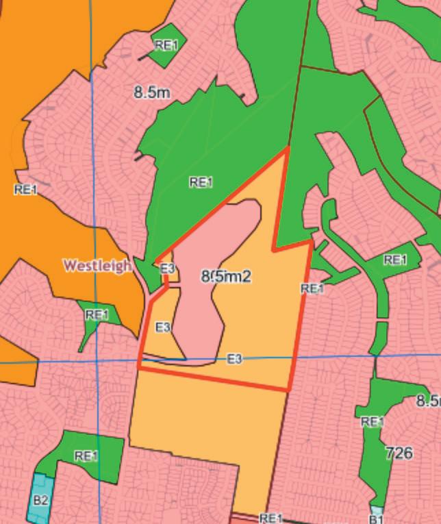
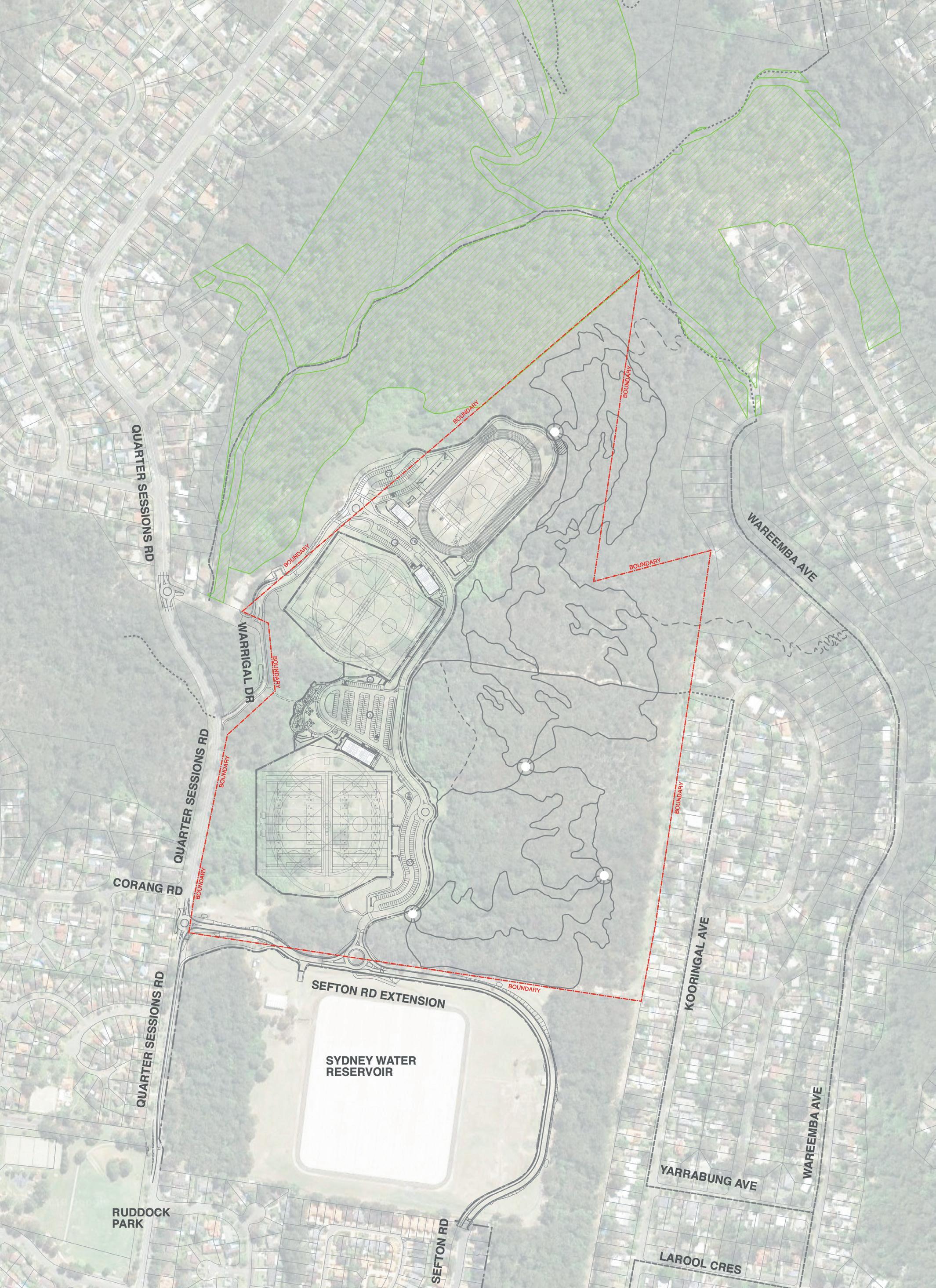
Community land within Westleigh Park is proposed to be categorised as Sportsground, Natural Area (Bushland) and General Community Use. Categorisation has been determined in accordance with the LG Act, Division 2, Section 36. The Categorisation Mapping (and the Westleigh Park Master Plan it relates to) reflects the optimum relationship of uses and facilities to the park’s physical characteristics and for access to those facilities by the community. Section 5.0 of this PoM provides further explanation of the Land Categorisation Mapping for Westleigh Park .
The core objectives for management of community land categorised as a sportsground are:
(a) to encourage, promote and facilitate recreational pursuits in the community involving organised and informal sporting activities and games, and
(b) to ensure that such activities are managed having regard to any adverse impact on nearby residences.
The core objectives for management of community land categorised as a natural area (bushland) are:
(a) to ensure the ongoing ecological viability of the land by protecting the ecological biodiversity and habitat values of the land, the flora and fauna (including invertebrates, fungi and micro-organisms) of the land and other ecological values of the land, and
(b) to protect the aesthetic, heritage, recreational, educational and scientific values of the land, and

(c) to promote the management of the land in a manner that protects and enhances the values and quality of the land and facilitates public enjoyment of the land, and to implement measures directed to minimising or mitigating any disturbance caused by human intrusion, and
(d) to restore degraded bushland, and
(e) to protect existing landforms such as natural drainage lines, watercourses and foreshores, and
WESTLEIGH PARK – DRAFT PLAN OF MANAGEMENT February 2023 8
Figure 2.1: Westleigh Park site location (not to scale)
Dog Pound Creek Site
Westleigh Park Community Lands
WESTLEIGH
NORMANHURST
THORNLEIGH
Ruddock Park
QUARTER SESSIONS ROAD WARRIGAL DRIVE
Crown land excluded from PoM
(f) to retain bushland in parcels of a size and configuration that will enable the existing plant and animal communities to survive in the long term, and
(g) to protect bushland as a natural stabiliser of the soil surface.
The core objectives for management of community land categorised as general community use are: to promote, encourage and provide for the use of the land, and to provide facilities on the land, to meet the current and future needs of the local community and of the wider public:
(a) in relation to public recreation and the physical, cultural, social and intellectual welfare or development of individual members of the public, and
(b) in relation to purposes for which a lease, licence or other estate may be granted in respect of the land (other than the provision of public utilities and works associated with or ancillary to public utilities).
Figure 5.1 on page 40 identifies the separate categories of community land within Westleigh Park.
2.3 Environmental Planning and Assessment Act 1979
The Hornsby Local Environment Plan, 2013 (LEP) was made under the Environmental Planning and Assessment Act, 1979 (s.34A). Westleigh Park is currently zoned (R2) Low Density Residential and (E3) Environmental Management (refer Figure 3.3 following page). As a public reserve under Council ownership, following adoption of a PoM, the most relevant planning instrument governing any proposed development and activities in Westleigh Park is the State Environmental Planning Policy (Infrastructure) 2007 (the Infrastructure SEPP), and the Hornsby Shire Local Environment Plan 2013.
2.4 Relevant Legislation
Commonwealth Legislation
Environment Protection and Biodiversity Conservation Act, 1999 (EPBC Act)
NSW Legislation
Local Government Act, 1993
Environmental Planning and Assessment Act, 1979
http://www.comlaw.gov.au/Details/ C2014C00140
SEPP State Environmental Planning Policy (Biodiversity and Conservation) 2021
SEPP Koala Habitat Protection
Rural Fires Act 1997
https://legislation.nsw.gov.au/view/html/ inforce/current/epi-2021-0722
https://www.planning.nsw.gov.au/ Policy-and-Legislation/Environment-andHeritage/Koala-Habitat-Protection-SEPP
http://www.legislation.nsw.gov.au/maintop/ view/inforce/act+65+1997+cd+0+N
Biosecurity Act (NSW) 2015 https://www.legislation.gov.au/Details/ C2020C00127
Biodiversity Conservation Act, 2016
https://legislation.nsw.gov.au/view/html/ inforce/current/act-2016-063
2.5 Relevant Council Policies
The below listed policies are current as of the time of publication of the Westleigh Park PoM. Additional policies, or newer versions of these policies may be created in the years to come. For a list of all current Council policies, please refer to Council’s website: https://www.hornsby. nsw.gov.au/council/forms-and-publications/publications/ strategic-framework.
Community Plan
http://www.hornsby.nsw.gov.au/__data/ assets/pdf_file/0006/51729/FNLYourCommunityPlan2013-2023.pdf
Community and Cultural Facilities Strategic Plan (currently in preparation)
Delivery Program and Operational Plan
Hornsby Local Environmental Plan 2013
Hornsby Development Control Plan
Active Living Hornsby Stategy
Sports Facility Strategy
Unstructured Recreation Strategy
Sportsground Strategy
Walking and Cycling Strategy
Hornsby Play Plan
Water Sensitive Hornsby
http://www.hornsby.nsw.gov.au/council/ about-council/corporate-documents-andreports/delivery-program
http://www.legislation.nsw.gov.au/maintop/ view/inforce/epi+569+2013+cd+0+N
http://www.hornsby.nsw.gov.au/property/ development-applications/hornsbydevelopment-control-plan
http://www.hornsby.nsw.gov.au/council/ about-council/Join-the-Conversation/ active-living-hornsby-strategy-alhs
http://www.hornsby.nsw.gov.au/media/ documents/about-council/corporatedocuments-and-reports/sports-facilitystrategy/Sports-Facility-Strategy.pdf
http://www.hornsby.nsw.gov.au/media/ documents/about-council/corporatedocuments-and-reports/unstructuredrecreation-strategy/Unstructured-Recreationhttps://www.hornsby.nsw.gov.au/lifestyle/ sports-and-recreation/facilities/ sportsgrounds/Hornsby-Shire-SportsgroundStrategy
https://www.hornsby.nsw.gov.au/lifestyle/ sports-and-recreation/biking/20172018-bikeplan-review
http://www.legislation.nsw.gov.au/maintop/ view/inforce/act+30+1993+cd+0+N
http://www.legislation.nsw.gov.au/maintop/ view/inforce act+203+1979+cd+0+N
https://future.hornsby.nsw.gov.au/play-plan/ https://future.hornsby.nsw.gov.au/ water-sensitive-hornsby-strategy/
https://future.hornsby.nsw.gov.au/ biodiversity-conservation-strategy/ Sustainable Hornsby https://future.hornsby.nsw.gov.au/ sustainable-hornsby-2040-strategy/
Biodiversity Conservation Strategy
WESTLEIGH PARK – DRAFT PLAN OF MANAGEMENT February 2023 9
WESTLEIGH PARK – DRAFT PLAN OF MANAGEMENT February 2023 10
0.5km 1km 2km
Figure 3.1: Context Plan, Westleigh Park
Westleigh Park Plan of Management site
Ruddock Park
Berowra Valley National Park
Berowra Valley National Park Reddy Park
Headen Park
Normanhurst Park
Kenley Park Brickpit Park
Hornsby Park
3.0 Site Description
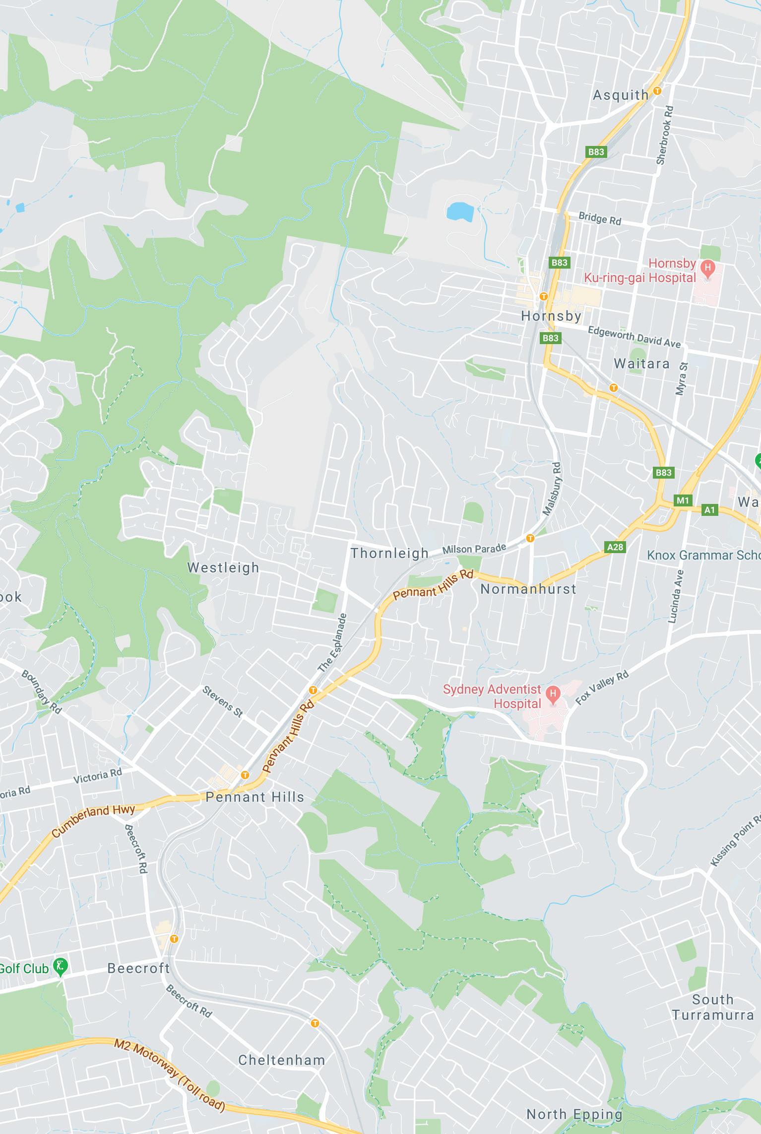
3.1 Context
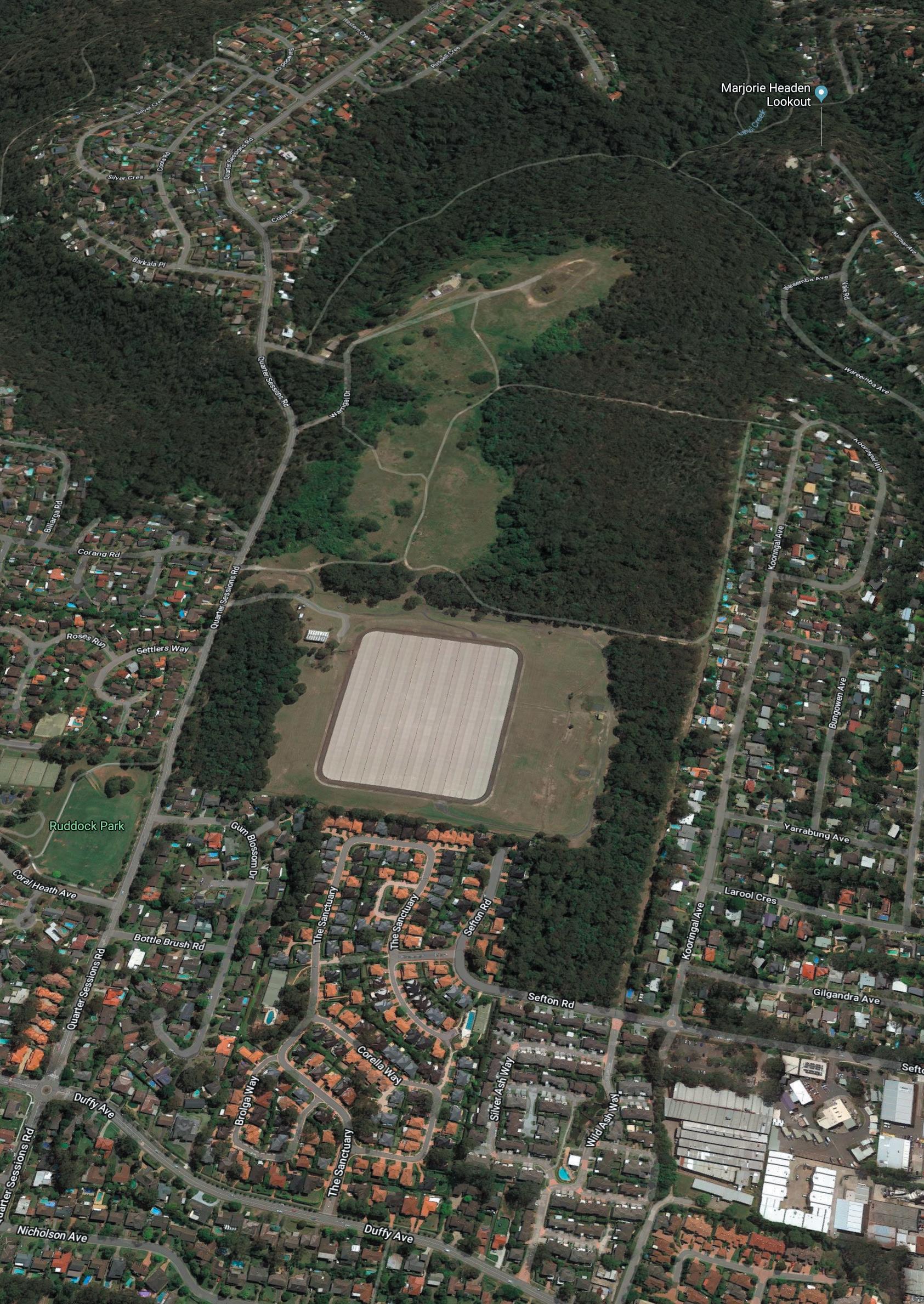
Westleigh Park is located at 62 Quarter Sessions Road, Westleigh, approximately 2km from the Hornsby Town Centre, the largest commercial centre in the Hornsby Shire. Figures 3.1 and 3.2 show the location and surrounding context of the park. Vehicular entry to the park is currently available from Warrigal Drive off Quarter sessions Road.
The Westleigh Park site is owned by Hornsby Shire Council and is currently zoned Low Density Residential (R2) and Environmental Management (E3) in the Hornsby Local Environmental Plan (LEP) 2013, with adjoining lands zoned as (R2) Low Density Residential or (RE1) Public Recreation (refer Figure 3.3). It is adjoined by a Crown Land site (Lot 7332/DP1167215) bounded by Warrigal Drive and Quarter Sessions Road which is the responsibility of Minister for Lands and is not subject to this PoM.
The Dog Pound Creek land is owned by Hornsby Council and is addressed by a separate Generic PoM for Community Land and Crown Reserves (Planning District 2). It is mostly bushland zoned (RE1) Public Recreation. It includes a BioBanking area as referred to in section 4.4 Environment.
3.2 Westleigh Park at a glance
ITEM DESCRIPTION
Name: Westleigh Park
Address: 62 Quarter Sessions Road, Westleigh
Ownership Community land owned by Hornsby Council
Lot & DP Westleigh Park site: Lot 101 DP 1217395
Crown Land Island *: Lot 7332 DP 1167215 (*adjoining land - not subject to this POM)
Area Westleigh Park site: 36 Ha
Zoning: Hornsby Local Environmental Plan (LEP) 2013
Westleigh Park site (R2) Low Density Residential and (E3) Environmental Management
Categorisation Not currently categorised
Care, control, management: Hornsby Council
Land cover Westleigh Park site:
10 Ha Cleared land
26 Ha Bushland - including Threatened
Ecological Communities (refer 4.4
WESTLEIGH PARK – DRAFT PLAN OF MANAGEMENT February 2023 11
Environment R2 4000000
R2 R2 R2 R2 R2 R2 R2 R2 500
m2
m2
Figure 3.2: Westleigh park site (not to scale)
Figure 3.3: Current Zoning (not to scale)
Sefton Road
Dog Pound Creek Site
WESTLEIGH
NORMANHURST
THORNLEIGH
Ruddock Park
SESSIONS
Crown land excluded from PoM
QUARTER
ROAD
WARRIGAL
Westleigh Park
DRIVE
3.3 Site History
Aboriginal Heritage
As identified in the Due Diligence Assessment Report for the Westleigh Park complex, prepared in 2019 by GuriNgai Tribal Link Aboriginal Corporation, “the study area for Westleigh Park, has been for generations and still is, home to the GuriNgai & Darug Mobs (Wannangini).” In addition, the area was seasonally occupied in various locations by the Darginyung peoples. The connections to this area for each of these groups includes pre and post European colonisation.
Traditional areas occupied by the GuriNgai/Wannangine comprise of; all of Port Jackson catchment including the tributaries of Middle Harbour and Lane Cove River; the Broken Bay catchment including tributaries of Brisbane Water, Cowan Creek and Pitt Water; the water shed along Peats Ridge following along the range through to Kulnura; as well as the Lakes of the Central Coast to lower Lake Macquarie.
The Due Diligence Assessment Report outlines that well known and documented members of the Guringai mobs were; Ned & Margaret, Ellen White, Marika, Charlotte, William Bird, Boongaree (Bungaree), Matora, Mosquito, Jewfish, Cora (Gooseberry), Flathead, Long Dick, Sophy (Booranga), Kitty and Charlotte Ashby.(nee.Webb). Their presence in this area was initially recorded pre 1790 and references to these GuriNgai people are located on: Government Blanket lis; Court Bench records taken in the Gosford areas; Colonial Secretary minutes held at Gosford Library; early recordings from surveyors; journals written by Rev.L.E.Threlkeld, Rev. Glennie, Matthew Flinders, Augustus Earl, R.H Mathews; and current AIATSIS maps.
Family clan groups of the GuriNgai include (but not limited to), Walkaloa, Narrara, Garigal, Boregegal,Turramarragal, and Geawegal. These families occupied, protected, preserved and utilised their natural surroundings and maintained a sustainable environment for over 60,000 years. The area now known as Hornsby was home to the Garigal (and Darug from inland Hornsby Shire), who fished, hunted, celebrated and honoured their traditional Country. Natural water courses were a constant source of food and the environment produced all the requirements necessary for survival, from nuts, roots, berries and vegetables to thick barked trees for shields, shelters, coolamons.
Weapons and tools were created from natural materials, utilising the environment to sharpen, maintain and store these items. Remnants of these weapons and tools are identified today across the entire Australian landscape. Ridgelines were an intergral passageway through Country
and provided visual aspects across large portions of Country.
An Aboriginal Cultural Heritage Assessment (ACHAR) was undertaken for the site in 2020 which identified the following Statement of Aboriginal Cultural Significance:
“The land containing the project area embodies the collective and contemporaryAboriginal social values of loss, remembrance and resilience. From a traditional viewpoint, the land represents an important meeting place along a well-travelled path and therefore embodies the shared values of family, community and social cohesion. Looking forward, this land still retains the potential to educate and celebrate a unique connection to Country by promoting a shared understanding of the area’s cultural values.”
The ACHAR notes the following site specific values:
• Social
• Spiritual
• Aesthetic
In addition the ACHAR refers to the existing dead Scarred Tree on site which is recommended to be relocated to a safe location for conservation and interpretation on the site (an indicative location is shown on the maps in this draft Master Plan), as well as other aspects of cultural heritage importance in the local area which are to be conserved and protected.
Non-Aboriginal Heritage (refer Figure 3.4)
Information related to historical use of the site since European colonisation is largely derived from the 2014 Site investigations Report created by JBS&G. This work provides a summary of key site changes identified from aerial images.
1930:
• Southeast areas of the site were cleared, with a number of designated fenced areas and tree rows along some internal fence lines.
• Areas of agricultural practices (market gardens and orchards) and residential development were observed to the south and southeast of site.
• An unsealed trail along the current Quarter Sessions Road alignment existed along the western site boundary
WESTLEIGH PARK – DRAFT PLAN OF MANAGEMENT February 2023 12
WESTLEIGH PARK – DRAFT PLAN OF MANAGEMENT February 2023 13 Timeline 1788 1800s 2018
Pre-European colonisation area was occupied by the GuriNgai peoples
Figure 3.4: Indicative timeline Refer also to following page for locations
Westleigh Park Concept Master Plan Study
1900s
Rural and orcharding activities in adjoining lands
1998
2004
1970s 1960s
Construction demolition landfill undertaken on site
Night soil depot operated on site
Borrow pit excavation for rock for Sydney Water Reservoir
Treated wood storage on site
Sydney Water investigations for potential residential subdivision in R4 zone
Intermittent construction spoil during 1970’s
1952
1980s RFS fire training on site including use of foams containing PFAS
1943
2016 Council aquisition of Westleigh park site
2023
3.3 Site History (continued)
1943:
• Majority of the south and the western site cleared into a series of elongated rectangular ‘pads’ with a number of building structures in the central south of the site.
• A number of dirt trails lead to two smaller cleared areas occupied by structures located in the north
• Quarter Sessions Road and Warrigal Drive to the west appear as unsealed trails.
1951:
• the majority of the site now one clearing, extending to the northwest boundary and northern tip of the
• Trails and patches of cleared land observable within surrounding woodland.
• The northwest boundary appears to be a tipping face, larger in extent than visible in 1943
• Increased areas of cleared land can be observed surrounding the site in all directions.
1961:
• Vegetation around the site is notably less dense in many areas.
• Quarter Sessions Road and Warrigal Drive are more visibly formed, and a second entry off Warrigal Drive to the northern tipping area is evident.
• Land to the southwest appears to consist of a number of cleared areas and a long fenced or walled enclosure extending considerable length to the west, which may be some form of animal exercise pen.
• Land surrounding contains a much higher level of apparent residential development, particularly to the east, with orchards and market gardens further to the southwest.
1970:
• The Sydney Water reservoir can be observed under construction to the south of site.
• The Thornleigh residential area extends to the site’s eastern boundary, and to the west residential areas of Westleigh are being developed.
1986:
• Construction of the reservoir appears complete.
• A small building exists in the north-western portion, which may be the location of the current RFS building beyond the northwest boundary.
• Residential areas west and east are further developed.
1994:
• More defined trails can be observed around site with some previously vegetated areas appearing less dense.
• Scatted materials can be observed in areas, suggesting the potential for dumping / fly tipping, particularly in the northeast area.
• Areas of potential burnt ground appear east of the building northwest of the site where the RFS currently exists.
• An oval dirt track is visible in the northeast suggesting use for recreational vehicles such as dirt bikes.
The Site Investigations by JBS&G also provide a specific summary related to some key site uses over time. Refer also to Figure 3.5 Location of past uses on page 16.
Night Soil Depot and Tarring Plant
• A night soil depot was operated from around the early 1950’s until 1962 by Hornsby Shire Council
• Sydney Water records indicate night soil dumping operations by Hornsby Council (or subcontractors) were to cease mid 1962, while tarring operations continued to around April 1963 due to a lack of alternate tarring facility locations.
• The depot included a tarring plant for treatment of metal sanitary pans used to collect sanitary wastes (i.e. night soil). Sanitary pans were collected regularly and replaced with an empty one. At the depot, following disposal of the night soil, used empty pans were cleaned and tarred and then placed back into service. It is understood that pans were sometimes disposed with the night soil, and there may be old pans in night soil burial areas at the site.
• Other activities that may have occurred at the night soil depot may have included “ploughing in night soil, washing and tarring pans, assisting unloading night soil, loading pans at the depot, attendance on boilers, cleaning, washing and greasing of vehicles in the depot, cleaning premises at depot and the attendance (including grooming,stabling and feeding) upon horses”.
• Pans were either washed and cleansed “with hot water and subjected to steam under pressure in an [approved] apparatus”, or “with hot water in an automatic washing and tarring machine in which the pan is immersed in a bath of molten tar”;
WESTLEIGH PARK – DRAFT PLAN OF MANAGEMENT February 2023 14
• Vehicles used to convey pans were to be cleaned in a covered structure with a drained cement floor with the use of steaming and washing appliances, with drainage to be disposed in shallow trenches of the kind used for disposal of night soil.
• It is noted the depth of disposal would be limited by the depth to bedrock, which may be between approximately 0.6m and approximately 3m north to south across the site, although it is likely the bedrock surface will vary. Information contained within Sydney Water files, indicated some washing activities associated with the night soil depot occurred near the current southwest site entry.
• Sydney Water records contained a description of the tarring plant from February 1962. It was noted that the plant handled 5,000 sanitary cans per week.
• The plant was housed in a permanent timberframed, corrugated iron building with concrete floor, some 90 to 100 feet in length. The building housed a boiler, cleaning and tarring facilities, with the cans being handled automatically by conveyors from one process to the next.
• In 1962 it was recommended to bulldoze all affected night soil from the depot area to cover the garbage area, when plans for a second reservoir north of the current one were being considered.
Municipal Landfill
• Council operated a landfill on land immediately north of Portion 307, including the area occupied by the existing Westleigh Rural Fire Brigade Station.
• The nature of the landfill is implied to be at least partially putrescible by reference in historical documents to a ‘garbage dump’ and ‘rubbish tip’. Like many Council landfills there is potential for wastes to include a mixture of general rubbish, green waste, soil and demolition/building materials, including the potential for asbestos containing material (ACM).
• Information in Sydney Water files indicates the landfill operations ceased in 1963, which is consistent with historical aerial photographic evidence
• File notes suggest the removal of 2 foot across the surface of the night soil depot was removed and the ‘garbage dump’ covered prior to its cessation in December 1963.
• Other records note that rubbish (non putrescible) was covered with 12 inches (1 foot) of soil.
Borrow Pit
• The RFP and historical documentation indicates an area in the northwest of the site, was used as a source of rock during construction of the Thornleigh Reservoir south of the site.
• Approximately 31,000 cubic yards (approximately 23,700 m3) was won from the borrow pit. Based on an approximate area of 11 690 m2
• The approximate volume excavated (23,700 m3), the approximate depth of the borrow pit has been estimated to be 2m.
Other Uses
• In 1973 a portion of the northern area of the site was leased to Mitchell & Fernance Pty Ltd (M&F)
• State Library records indicate M&F were associated with Taylor, Allen & Co. Ltd (TACL), owning timber growers, merchants and sawmills, and ships.
• Records indicate TACL received quotations from 1971-1974 for Miscellaneous Mitchell & Furnance Impregnation, suggesting M&F provided timber impregnation services, and the pole-like features may have been timber power poles. The impregnation process could have used a number of chemicals including resins, coal-tar creosote, copper-chromearsenic (CCA) or organic solvents.
• In 1970 coal-tar creosote was dominant for treatment of power poles.
• It is also understood that the local fire brigade have used the Sydney Water site for fire training including live fire drills
• Sydney Water files contained information indicating that a large area of the site had large pipes and piles of spoil scattered across the site, with one file note from 29 August 1974 indicating spoil from construction works in the district was being deposited at the site.
WESTLEIGH PARK – DRAFT PLAN OF MANAGEMENT February 2023 15

WESTLEIGH PARK – DRAFT PLAN OF MANAGEMENT February 2023 16 Por 3 06 Por 3 07 So ur ce: Base Im ag e - © N ea r Ma p w ww n ea rm ap com i ma ge ry da te 0 8- 02 -2 01 4 a ccesse d 2 5- 03 -2 01 4 A4 Rev 0 Descr ipti on Or igi na l Issue - R0 2 Drn SE Date : 08 -1 2- 20 14 Sca e: Clie nt : Sy dn ey W at er Pr oje ct : Th or nle igh R es er v oir As s es s men t - ESA Jo b No : 4 33 86 File Na me: 43 38 6 0 3 © 20 14 JBS&G 0 50 10 0 25 m Leg en d: Si te B ou nd ary Hi st ori ca l P orti on B ou n da ry Dev e lo pa bl e A rea As s u me d Ex te nt of B orro w P i t (1 97 0) La nd fil l E nc roa c hm e nt (1 96 1) Ni gh t S oi l De po t (1 96 1) Tre ate d Wo od S to rag e (1 97 0) Dat um: GDA 19 9 4 MGA Zon e 5 6 - A HD 1:4 0 0 0 Fig ure 3 : Hi st ori ca l Si te Land U se Qua r t e r Se ss ions Road Figure 3.5 Location of past uses source: Site Investigation JBS&G 2014
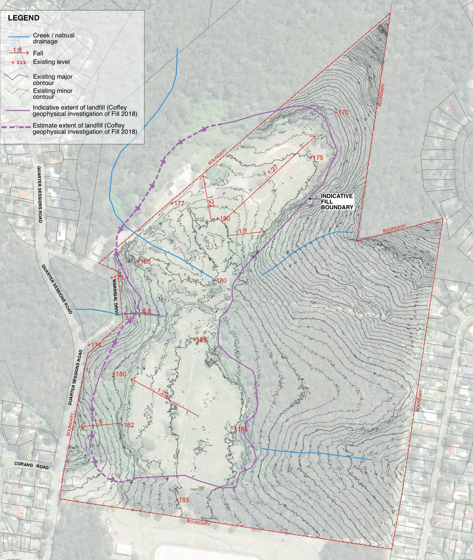
3.4 Environment Topography
The site lies at approximately 171-186m Australian Height Datum (AHD) on an approximately north trending ridgeline. The land slopes away from the centre of the site to the east and west, while the northern areas slope to the northwest, north and northeast towards gullies (refer Figure 4.6 following page). Falls across the existing landform range between 1:20-1:30 which is significantly steeper than a playing field platform (generally 1:100).
Geology
Most of the site is assumed to be underlain by Ashfield Shale along the top of the central ridgeline, with the northwest and northeast areas underlain by Hawkesbury Sandstone.
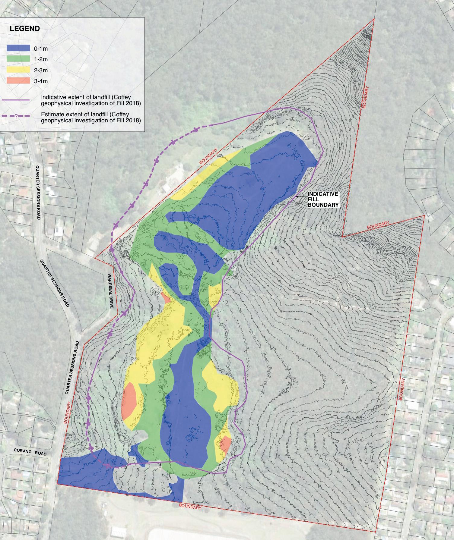
A borrow pit (small quarry) in the north of the site was used as a source of rock during construction of the Thornleigh Reservoir south of the site. Approximately 23,700 m3 was won from this excavation. Based on an approximate area of 11,690 m2 the indicative depth of the borrow pit has been estimated to be 2m. (Sydney Water)
This suggested that the depth of fill/soil overlying bedrock may vary from up to approximately 3m below ground level near the southern site boundary, to less than 1m below ground level towards the northern site boundary.
Drainage
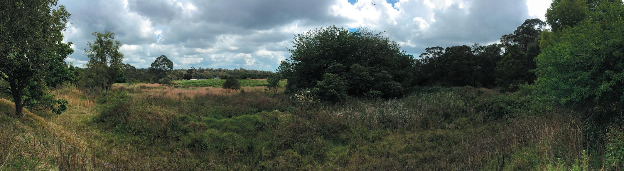
Surface runoff generally falls to the east and west, away from the ridgeline and into the surrounding bushland areas through natural drainage lines and as infiltration. In major storm events, runoff travels via overland flow paths to nearby watercourses (Civil Stormwater Report by TTW). Through the centre of the site (in the assumed area of the former quarrying borrow pit) is a zone of impeded drainage (refer Figure 3.6 following page and image 3 page 20).
The JBS&G report noted that based on the geological and topographic setting of the site, shallow perched groundwater may be encountered towards the interface of residual soils and underlying bedrock, which would be anticipated to flow with local topography. The depth of any perched water will be dependent on the depth to bedrock, which may vary between approximately 1m in the north to 3m in the south, and rainfall patterns. Deeper groundwater may be encountered in more permeable zones at depth in underlying shale/sandstone bedrock
Landfill and contamination
As identified in 3.3 Site History the site has been subject to a range of former uses including:
• A night soil depot and tarring plant
• Timber pole manufacturing/treatment
• Municipal landfill
• Borrow pit within northern part of the developable land
• Firefighting training in the northern part of the developable land
The landfill area is classified in the Site Investigations Report by JBS&G as “solid waste” including remnant putrescible material. JBS&G mapped borehole tests across the site to develop an indicative extent and profile of past landfilling across the site (Refer Figure 3.7 Indicative Landfill depths to following page) This indicates 40-50% of the landfill area has a depth of one metre or lower with up to 2-4m depth in zones along the south western and eastern boundaries. The JBS&G investigations were supplemented in 2018 by Geophysical investigations by Coffey Partners. This generated a further refinement of the landfill extent indicated by the solid pink line on Figure 3.7 and a dashed line where existing conditions (gradients and vegetation) precluded more definitive identification.
The 2018 Appraisal of Remedial Approaches by Coffey Partners undertaken as part of the Concept Master Plan noted that contamination issues that require remediation and/or management, include:
• Bonded and friable asbestos fragments within fill across the developable area, and on the surface soil of the EMZ (relating to potential illegal dumping)
• Soils within fill impacted with hydrocarbons, including polycyclic aromatic hydrocarbons (PAH)
• Soils within fill impacted with lead
• Spot dumping of waste within the EMZ
The JBS&G (2014) DSI and the Arcadis (2017a) RAP do not consider that landfill gas or groundwater contamination issues are of concern for the site.
Per and poly-fluoroalkyl substances (PFAS) contamination associated with the former fire-fighting training activities on the site was assessed by Senversa in 2018. In general minor PFAS impacts were identified and a number of further investigations were recommended by Senversa. All identified PFAS contamination will require remediation by the State Government prior to solid waste remediation and park earthworks on site by Council.
WESTLEIGH PARK – DRAFT PLAN OF MANAGEMENT February 2023 17
WESTLEIGH PARK – DRAFT PLAN OF MANAGEMENT February 2023 18
Figure 3.6 Topography, drainage and estimated extent of landfill
WESTLEIGH PARK – DRAFT PLAN OF MANAGEMENT February 2023 19
Figure 3.7 Indicative Landfill depths (source: JBS&G 2014)
Vegetation
Vegetation Community Mapping has been completed in and is reflected in Figure 3.8 Ecological consultants also advised the Concept Master Plan process on habitat protection. These reports noted that threatened flora was observed on site including:
• Darwinia biflora NSW Biodiversity Conservation Act 2016 (BC Act)

Commonwealth Environment Protection and Biodiversity Conservation Act 1999 (EPBC Act)
• Epacris (BC Act) purpurascens var. purpurascens
• Melaleuca (BC Act, EPBC Act) deanei
• Tetratheca (EPBC Act) glandulosa
Vegetation communities on the site include Sydney Turpentine Ironbark Forest (STIF) listed as Critically Endangered under the Environmental Protection and Biodiversity Conservation Act (EPBC Act) and Biodiversity Conservation Act (BC Act). Duffys Forest is listed as an Endangered Ecological Community under the BC Act. Eleven species of Orchids have also been recorded on-site. The ecological consultants identified the high conservation significance of an existing Angophora sp. near the southern boundary of the site.
Council has entered into a BioBanking Agreement over part of the Dog Pound Creek lands as indicated on Figure 3.8 and 3.9. The Dog Pound Creek BioBanking area is covered by the separate Generic PoM for Community Land and Crown Reserves (Planning District 2)

WESTLEIGH PARK – DRAFT PLAN OF MANAGEMENT February 2023 20
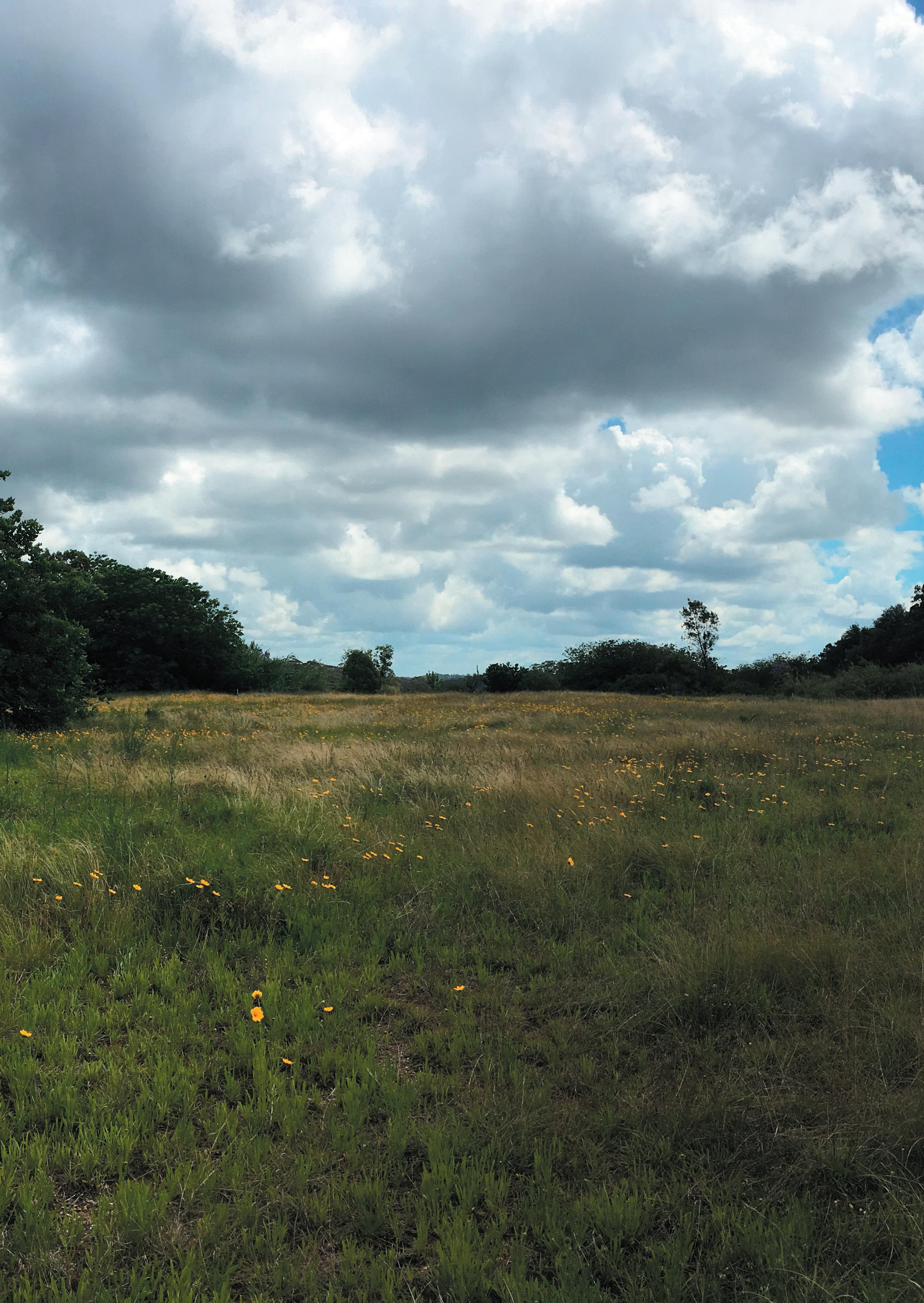
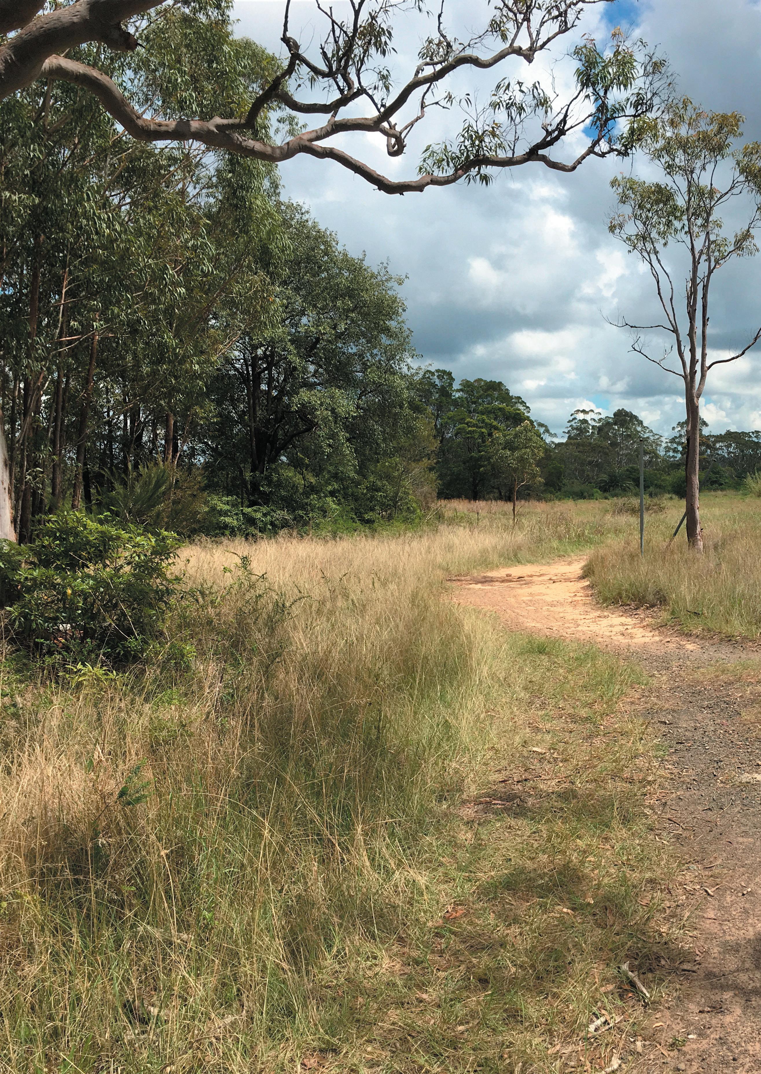
Site Images (source Environmental Partnership NSW unless noted)
1. Top right: Scribbly Gum in north of cleared area viewed towards north (source Danny Draper UTM 2019)
2. Middle: view towards south east at southern boundary of site
3. Bottom: view north west across impeded drainage area in middle of site
2.
3.
1.
Site Boundary


BioBanking Site
Vegetation Zones 20221031
Duffys Forest
Blue Gum Diatreme Forest
Sydney Turpentine-Ironbark Forest
Sydney Coastal Sandstone Gully Forest


Sydney Hinterland Apple-Blackbutt Gully Forest
Sydney Hinterland Dwarf Apple Low Woodland
Sydney Coastal Sandstone Bloodwood Shrub Forest
Typha
Exotic
Exotic Grasslands
Communities
Figure 3.8 Adjoining vegetation communities (source: Eco Logical Australia 2023)
Map
Projection:
1:6,000 at A4 Portrait
WESTLEIGH PARK – DRAFT PLAN OF MANAGEMENT February 2023 21
0 90 180 270 360 m
20230220_Westleigh Vegetation
Scale:
MGA zone 56 ¬
location of features and boundaries are indicative only,
not been surveyed. Aerial photography may not align with cadastral boundaries. Hornsby Shire Council accepts no responsibility for any incident arising from any inaccuracy. Copyright © Hornsby Shire Council 2019; © The State of New South Wales; Aerial imagery: © NSW Department of Finance, Services and Innovation 2016 Important Notice! Hornsby Shire Council 296 Peats Ferry Road HORNSBY NSW 2077 Telephone: 02 9847 6666 hsc@Hornsby.nsw.gov.au Email:
Date: 20/02/2023 GDA94 /
Dimensions,
their actual position has
BioBanking Area
WESTLEIGH PARK – DRAFT PLAN OF MANAGEMENT February 2023 22
Figure 3.9: Biobanking area to Dog Pound Creek (source: Hornsby Council)
3.5 Overview of Current Use
Past uses of the site are outlined in section 3.3. These have shaped the disturbed nature of the cleared portion of the site and created the need for a site remediation programme.
The subject site currently has usage to the cleared section of the site including Mountain Bike (MTB) trails and general walking and dog walking by the local community. The trail network through the cleared zone of the site and connections to adjoining streets.
The bushland area of the site contains a network of informal trails that have been built over several years by mountain bike (MTB) recreational users. Council is undertaking investigations to help inform decisions about the future of mountain bike use of this bushland areas. There is pressure across the Hornsby district and through surrounding National Parks areas for this recreational pursuit to be effectively catered for and Council is considering whether this location is appropriate.
An initial assessment of the impacts of the mountain bike use in the Natural Areas at Westleigh was undertaken by Council in December 2017. The assessment identified a range of existing, emerging and potential environmental impacts resulting from mountain bike activities. The assessment concluded that a sustainable network at this site could contribute to the regional provision of mountain bike trails.
Ongoing investigations into the potential for mountain bike use in bushland areas are currently being
undertaken.
3.6 Potential Use
Council’s Sports Facility Strategy identified the need for additional sporting facilities to meet current and future needs within the Local Goverment area. Westleigh Park has been identified by Council as a key opportunity to help meet this demand.
Council commissioned a concept Master Plan in 2018 to review potential arrangements of recreational uses on the site integrated with an approach to site remediation and earthworks. Council’s brief identified potential uses to be considered:
multi-use sporting fields (night lit and irrigated) for various organised sports including the possibility of a synthetic grass sportsground and athletics track
amenities buildings, grandstands, and maintenance sheds
play facilities and provision for active and passive recreation,
bushwalking tracks, and mountain bike trails,
pedestrian and cycle shareways with links to nearby Ruddock Park,
car parking areas to service park and all recreation facilities,
roads for access and circulation, and
a link road between Quarter Sessions Road and Sefton Road
The concept Master Plan described in section 4.0 is the outcome of this study and is Council’s preferred Master Plan direction for the site.
WESTLEIGH PARK – DRAFT PLAN OF MANAGEMENT February 2023 23
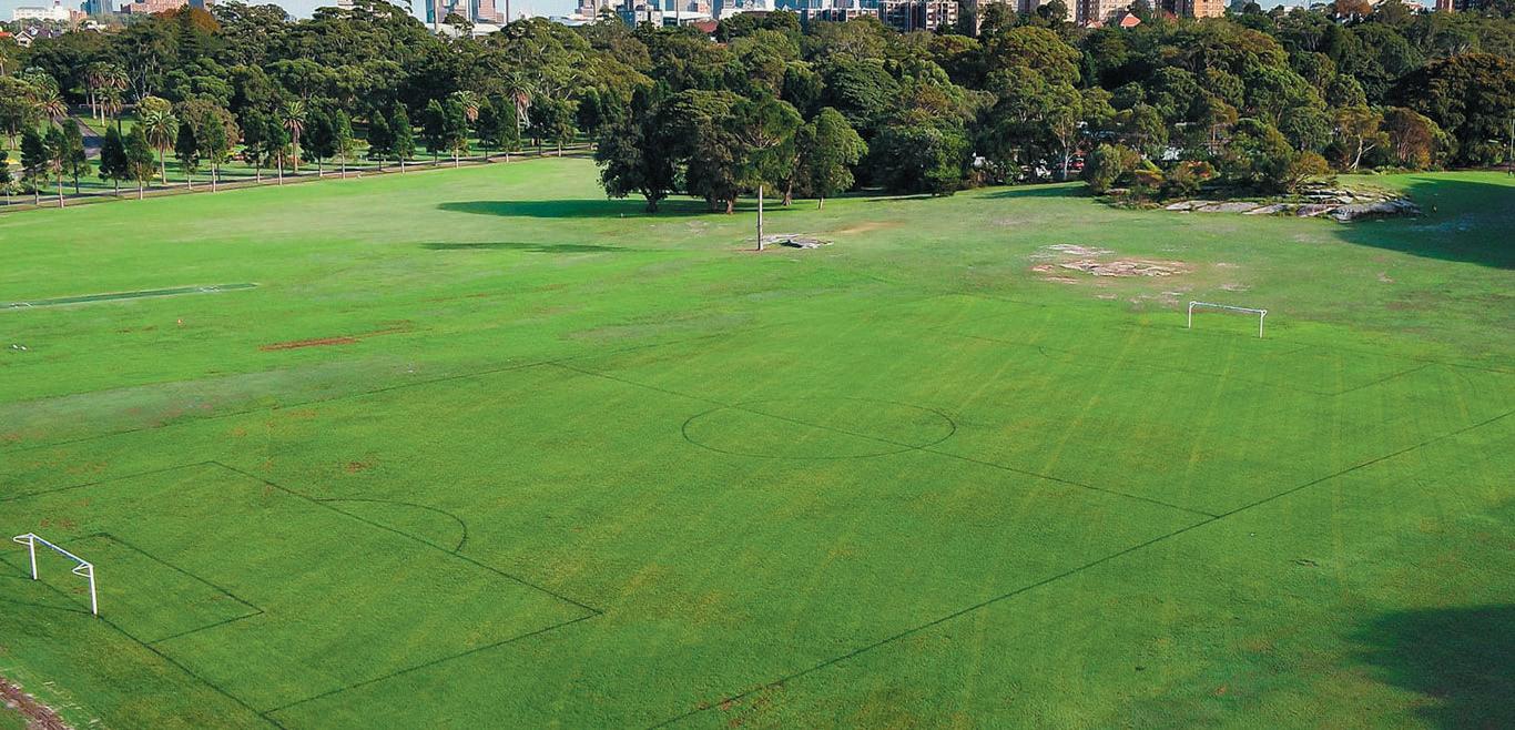
Image Source: visitnewcastle.com.au
Centennial Park - multi purpose parklands.
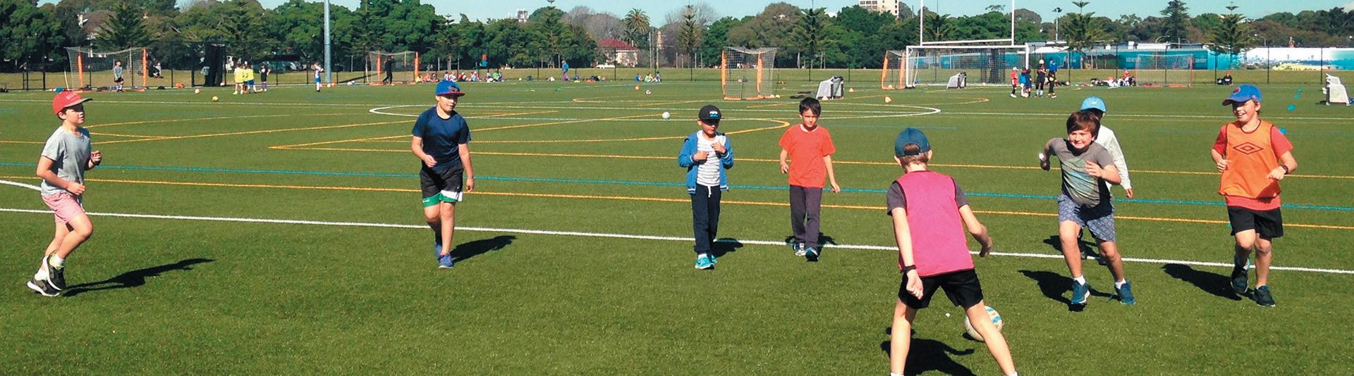
Image Source: Greater Sydney Parklands
Centennial Park - multi purpose parklands.
Image Source: Sydney.com
Centennial Park - multi purpose parklands.
Image Source: Centennial Parklands Sports Centre
Centennial Park - multi purpose parklands.
Image Source: centennialparklands.com.au

WESTLEIGH PARK – DRAFT PLAN OF MANAGEMENT February 2023 24
3.7 Key Issues for Westleigh Park
3.7.1 Connecting with Country
The 2020 draft Aboriginal Cultural Heritage Assessment Report ACHAR and the Connecting With Country Framework in progress as at February 2023, identify the values of the site to Aboriginal people and the priorities for conservation and interpretation. These values should be conserved and celebrated through ongoing planning, design and management of the site.
3.7.2 Site Remediation
As identified in section 3.4 Site History, the site has been subject to a range of past activities which have potential to impact the usability of the area as it stands. As such, a remediation programme is required. Investigations were undertaken by JBS&G for Sydney Water in 2014 to review works required to enable residential development of the site in line with the site zoning. This investigation was supplemented in 2018 by Geophysical investigations by Coffey Partners, as part of the recreational Master Plan studies for the site. A remediation and earthworks strategy has been developed and is outlined in section 4.3.
3.7.3 Earthworks
A remediation approach for the site is intrinsically linked to any earthworks that are intended to be carried out for implementation of sports fields or other recreational facilities. Truck and machinery movements on local roads have potential to impact residential areas and so a balanced cut and fill approach limiting imported materials to those required for landscape finishes would be preferred if feasible.
3.7.4 Traffic and Car Parking
The development of sports and community facilities on the site will generate additional traffic flows through the adjoining neighbourhood across the week and in particular on weekend game days. Previous studies examined the local road system and assessed potential impacts of a range of uses including residential (Masson Twiney 1998) and recreational (Positive Traffic 2019).
The preliminary traffic and transport assessment undertaken in 2019 (based on 2019 data) identified a need for road network upgrades to cater for the additional traffic generated by the Master Plan proposal. Since then, NorthConnex, which was open to traffic in October 2020, has changed the traffic conditions within the study area. Council identified the need to update the traffic assessment to incorporate the influences of NorthConnex on traffic volumes and patterns and engaged Bitzios Consulting to carry out the additional review.
Bitzios developed a microsimulation model and used the model to inform road and intersection upgrade requirements, assess the impact of the proposed Sefton Road extension and review active and public transport facilities and potential improvements. This assessment suggests that the proposed Sefton Road extension would be required at some stage. In addition, a through access between Quarter Sessions Road and Sefton Road would provide a supporting emergency egress route for the community.
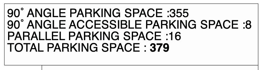
In addition, the traffic investigations identified that provision of approximately 350 off street parking spaces within the Westleigh Park complex should be provided.
3.7.5 Urban Context & Range of Recreational Facilities
The Westleigh neighbourhood is served by a variety of parks in addition to extensive areas of natural bushland. Ruddock Park, located to the south on Quarter Sessions Road, is an important local park providing for a mix of active and informal recreational pursuits.
As noted in section 3.6, Council’s Sports Facility Strategy has identified the need for additional sporting facilities to meet current and future needs with Westleigh Park seen as playing an important future role in organised sports provision.
Westleigh Park also provides passive recreational opportunities such as local level play space. Such a facility would also complement the organised sports use within the park.
3.7.6 Pedestrian Connections and Legibility
Westleigh Park has a limited frontage to public streets and as a result few pedestrian entrances into the overall site. The creation of a hierarchy of pedestrian entrances and pathways will be an important contributor to linking the various spaces and facilities within the site and lifting the profile of the park with the community.
3.7.7 Environmental Conditions & Landscape
The park has significant vegetation communities that fringe the existing cleared area. Sports field development will be contained to existing cleared areas, and will be preceded by remediation or capping of past landfill areas. Bushland will be conserved and protected during park development. Existing bushland to the eastern and western edges of the park will maintain a visual buffer to adjoining residential areas on Kooringal Road and Quarter Sessions Road.
WESTLEIGH PARK – DRAFT PLAN OF MANAGEMENT February 2023 25
4.0 Master Plan Development
4.1 Introduction
Community Land must be categorised in accordance with the LG Act. The category reflects the physical character and use of the lands. Each category is supported by Guidelines for Categorisation in the LG Act. The categories include:
• General Community Use
• Park
• Sportsground
• Area of Cultural Significance
• Natural Area, which has sub-categories as following:
- Bushland -Foreshore
- Wetland -Escarpment
- Watercourse
The LG Act also establishes core objectives for all categories of community land. The significance of the prescribed core objectives is to ensure that any activities or uses of the land are consistent with the core objectives for the prescribed land categorisation.
The table below sets out management targets for the core management objectives as defined by the proposed community land categorisations.
A separate Master Planning Study as described in the Westleigh Park Master Plan Report 2023, developed a concept Master Plan for the development of the park. This plan integrated the approaches to site remediation and earthworks to facilitate development of recreational facilities having close regard for the environmental values of the site. The Master Plan coordinates the various strategies that need to be pursued to optimise the community benefit of the parkland (refer 4.3 and 4.5)
4.2 Objectives and Performance Targets of the Plan
Core Objectives Performance targets
Sportsground
(a) to encourage, promote and facilitate recreational pursuits in the community involving organised and informal sporting activities and games,
1. A balanced provision of recreational opportunities in the park that address Shire wide sporting needs where possible achieving the best use of subject lands for community benefit.
2. Integrate flexibility to planning and development that enables facilities to respond to future requirements.
3. Provision of complementary informal use park areas that cater for day to day community recreational use.
(b) to ensure that such activities are managed having regard to any adverse impact on nearby residences and bushland.
1. Design that ensures the operations of the sports fields limits the impacts on the biodiversity of the adjoining natural areas.
2. Provision of additional site access to manage potential impact of traffic access to site during peak use times.
3. Provision of on site parking to limit parking impacts on adjoining streets.
4. Design of lighting within all required standards and codes to limit any impacts on adjoining residential areas and bushland.
5. Booking and Licence restriction of hours of operation as required to manage impacts of lighting and noise.
Natural Area (Bushland)
(a) to ensure the ongoing ecological viability of the land by protecting the ecological biodiversity and habitat values of the land, the flora and fauna (including invertebrates, fungi and micro-organisms) of the land and other ecological values of the land, and
1. Protect and enhance critically remnant bushland.
2. Protect and enhance areas of habitat known to support threatened species.
3. Identify any specific areas of bushland to have restricted access.
4. Allow equitable community access to natural areas. Where this is not possible consider controlled access such as guided walks through formalised bushland tracks.
WESTLEIGH PARK – DRAFT PLAN OF MANAGEMENT February 2023 26
Core Objectives
Natural Area (Bushland) (continued)
(b) to protect the aesthetic, heritage, recreational, educational and scientific values of the land, and
(c) to promote the management of the land in a manner that protects and enhances the values and quality of the land and facilitates equity of use and public enjoyment of the land, and to implement measures directed to minimising or mitigating any disturbance caused by human intrusion, and
(d) to restore degraded bushland, and
(e) to protect existing landforms such as natural drainage lines, watercourses and foreshores, and
(f) to retain bushland in parcels of a size and configuration that will enable the existing plant and animal communities to survive in the long term, and
((g) to protect bushland as a natural stabiliser of the soil surface.
General Community Use
To promote, encourage and provide for the use of the land, and to provide facilities on the land, to meet the current and future needs of the local community and of the wider public:
(a) in relation to public recreation and the physical, cultural, social and intellectual welfare or development of individual members of the public, and
b) in relation to purposes for which a lease, licence or other estate may be granted in respect of the land (other than the provision of public utilities and works associated with or ancillary to public utilities).
Performance targets
5. Any approved trail network within a natural area is to be managed in a sustainable manner to ensure conservation of ecological integrity of the site.
6. Provide interpretive signage and information regarding natural areas.
1. Provide amenities buildings to serve and support the recreational facilities on site.
1. Leases or licences authorised by this plan in accordance with the plan’s objectives and core objectives for the community land categorisation.
WESTLEIGH PARK – DRAFT PLAN OF MANAGEMENT February 2023 27
4.3 Key site development strategies
4.3.1 Remediation
The Remediation Approaches by Coffey 2018 as part of the concept Master Plan Study considers that (i) cap and contain, or (ii) consolidation and isolation with emplacement cell, accompanied with administrative controls utilising a long term environmental management plan (EMP), is the most practical approach to landfill management. It is noted however that the final remedial actions will be subject to approval and agreement of the Environmental Planning Authority (EPA) accredited Site Auditor.
Per- and poly-fluoroalkyl substances (PFAS) contamination associated with the former fire-fighting training activities on the site was assessed by Senversa in 2018. In general minor PFAS impacts were identified and a number of further investigations were recommended by Senversa. All identified PFAS contamination will require remediation by the State Government prior to solid waste remediation earthworks on site by Council.
In the environmentally sensitive zones of threatened Ecological Community (TEC) adjoining (referred as Environmental Management Zone (EMZ) in the Coffey Report 2018), the ‘cap and contain’ or ‘consolidation and isolation’ strategies would significantly disturb/destroy the vegetation communities. Therefore, the ‘cap and contain’ or ‘consolidation and isolation’ strategies would not be applicable. Instead, Coffey considers utilising a combination of (i) localised removal of dumped waste and asbestos; (ii) localised isolation of asbestos exposure in accessible areas, accompanied with administrative controls utilising a long term EMP, would be more practicable for the EMZ. The Coffey Report 2018 proposes remediation strategies for the site. The proposed strategies are consistent with recommendations discussed in the Remediation Action Plan (RAP - Arcadis, 2017), however vegetated areas must also be considered, in the context of minimising potential impact to TEC vegetation.
Cleared & Weedy Areas
Cap and contain to isolate the mixture of contamination in the fill. This includes excavation of landfill and relocation for consolidation and capping elsewhere on site. Where Synthetic field surfaces are being proposed the capping approach can be modified and significantly reduced subject to the nature of the field subbase.
EMZ
The adjoining vegetated areas within the EMZ are not to be promoted for recreational access, except in the case
of formalised tracks, and will have practical separation from the main park area (e.g., retaining walls/fencing). It is not proposed, due to potential impacts, that large scale removal of existing contaminants is undertaken in areas of high biodiversity value, e.g., Threatened Ecological Communities. However, minor hand picking and removal of spot dumping will be undertaken.
Within any potential formalised trail network, it will be necessary to undertake management as outlined in the RAP which is likely to include:
hand pick and remove asbestos
inspection by asbestos assessor
capping with VENM subject to Ecologist advise
All trails that traverse the “Bushland Protection’ areas may be provided with appropriate treatment, e.g., stone armoured or boardwalk to limit erosion other impacts.
4.3.2 Earthworks
Civil concept designs were prepared as part of the concept Master Plan Study and illustrate the proposed final levels concept and related earthworks strategy. Although the site appears quite level to undulating the majority of the site falls as a gradient of between 1:201:30 (vertical : horizontal). As a result over the extent of a sports field platform falling at a preferred 1:100, the edges of the platform will result in a deeper profile of fill material. In addition around 40% of the site is covered in fill to a depth of less than a metre.
Subject to detailed constructability assessment, it is proposed to excavate down to natural ground (Virgin excavated natural material (VENM)) across a proportion of the site and relocate the excavated material to “containment cells” within the major fill zones required to establish field levels. Site won material will be used were possible as capping material to these containment cells and as fill material to the major fill zones on the site. Some additional capping material to meet required specifications will be required to meet the needs of the capping exercise, which would have been brought into site regardless (soils for field turf etc). The final levels have been calibrated to account for a balanced cut and fill exercise focussing the requirement for imported material on landscape and related construction materials to provide suitable surface profiles for sports turf and the like.
WESTLEIGH PARK – DRAFT PLAN OF MANAGEMENT February 2023 28
4.3.3 Vehicular access and parking
A review of traffic and parking factors was undertaken in the development of the concept Master Plan.
The Report by TTW Transportation Planning concludes that the concept Master Plan for Westleigh Park met the recommendations of the Traffic and Access Assessment Report prepared by Positive Traffic in 2017 and updated in 2019 for Council, and further updated by Bitzios in 2021-23.
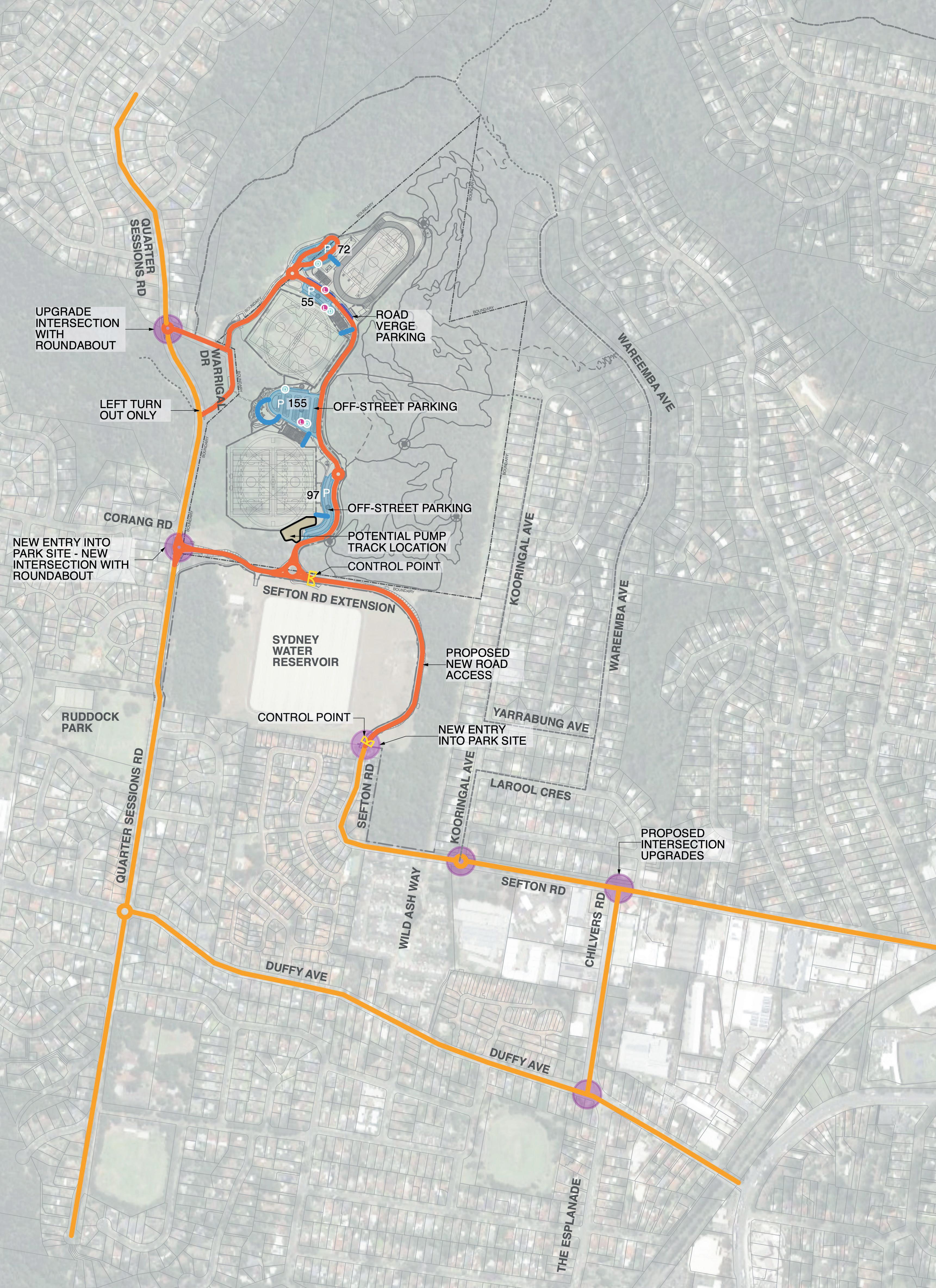
Key traffic and parking strategies include the following (refer to Figure 4.1):
The potential provision of 350 plus parking spaces within the park adjacent to proposed sporting fields.
Upgraded access into the Park from a new roundabout at Warrigal Drive /Quarter Sessions Road intersection
A new access into the site from Quarter Sessions Road near Coorang Avenue.
A new managed access into the site via a road connection to Sefton Road through Sydney Water lands. This link will be open at specific times to limit impacts on the local street network.
Past traffic and transport reporting including the 2022 Bitzios Report will guide traffic and parking provisions on the site and improvements to adjoining streets.
4.3.4 Pedestrian and cycle access
The park requires a network of pedestrian access that connects park entries and parking areas to recreational facilities and provides equitable access between those facilities. Figure 4.2 illustrates the proposed pedestrian access strategy for the site. A loop shared pedestrian / cycle system is integrated with internal pedestrian paths.
The shared path loop caters for cycle access across the site which is connected to the local / regional cycle network via Sefton Road and Quarter Sessions Road as identified on the Hornsby Bike Plan (refer to Figure 4.3).
Integration of main pedestrian and cycle access with road access points into the site at Warrigal Drive and near Coorang Avenue on Quarter Sessions Road will heighten the legibility and surveillance of these access points.
Design should facilitate appropriate separation for amenity and safety.
4.3.5 Environmental management
Environmental management considerations for the concept Master Plan have included:
The principles of avoid, minimise and mitigate have been implemented to reduce any impact on adjoining remnant vegetation.
To ensure the ongoing conservation of ecological values on the site, setbacks are to be maintained adjacent to remnant vegetation.
These setbacks are to ensure that any earthworks and other development do not impact on remnant vegetation and habitat.
Significant tree protection
To ensure the ongoing conservation of isolated trees, setbacks are to be maintained adjacent to retained trees. These buffers are to ensure that any earthworks and other development do not impact on remnant trees and habitat.
Fauna management
Habitat Assessments undertaken in 2016 by Council’s Natural Resources section have been supplemented by work undertaken across 2021-2023. The site survey indicated the site exhibits high diversity in birds species with 50 species observed including the threatened Square-tailed Kite (TSC) and summer migrants the Sacred Kingfisher, Eastern Koel, Channel-billed Cuckoo and Dollarbird.
There were only a few reptile species and few indications of mammals (scats and tracks, burrows and feeding scars). The vegetation is likely to support a variety of microbats and has preferred food resources of the Greyheaded Flying-fox (BC Act & EPBC) which is known to occur in this locality. The site also contains habitat that is likely to support other threatened species including Eastern Pygmy Possum, Red-crowned Toadlet, Powerful Owl, Glossy Black-cockatoo. An existing Eastern Pygmy Possum study in Council reserves has been extended to this site due to the presence of Bloodwood Scribbly Gum Woodland and Scribbly Gum Open Woodland that contain flora species preferred by this species.
The principles of avoid, minimise and mitigate have also been applied to potential impacts on fauna. Any residual impacts will be addressed through appropriate mitigation measures which will be included in the Biodiversity Development Assessment Report.
Biodiversity Development Assessment Report (BDAR)
A BDAR is to be provided to inform ongoing refinement of the Master Plan proposals. The assessment includes detailed appraisal and site survey of flora and fauna on-site, including the Threatened Ecological Communities to enable minimisation of potential impacts by the development.
Any localised residual impacts will be offset in accordance with relevant offset policies and schemes.
WESTLEIGH PARK – DRAFT PLAN OF MANAGEMENT February 2023 29
WESTLEIGH PARK – DRAFT PLAN OF MANAGEMENT February 2023 30
LEGEND Exist ng external road Proposed internal road with mountable kerb - 7m width in general and 8m width to wherever mountable kerb not applied Proposed intersection upgrade Proposed parking area - off street 90˚ Proposed maintenance access/ emergency access to field TR AFFIC & PAR KING D Accessible Parking (2 x parkings & 1 x shared area ) L Loading zone Proposed new entry into park site Proposed parking arearoad verge parallel Potentia pump track 90˚ ANGLE PARKING SPACE :355 90˚ ANGLE ACCESSIBLE PARKING SPACE :8 PARALLEL PARKING SPACE :16 TOTAL PARKING SPACE : 379 LEGEND Natural Area - Bushland S portsground General Community Use CATEGOR ISATION LEGEND Proposed S hared path2 5m width Pedestrian crossing/ refuge crossing - to be determ ned Potential refuge crossing - to be conf rmed Major pedestrian entry S econdary pedestrian entry Existing shared path SHAR ED PATH Proposed accessible shared path - 2 5m width PEDESTR IAN Proposed accessible pedestr an path - 1 8m width CR OSSING ENTRY Proposed pedestrian path with steps - 1 8m width PEDESTR IAN ACCESS AND WALKING S ydney Coastal S andstone Bloodwood S hrub Forest BioBanking EXISTING VEGETATION COMMUNITY Blue Gum Diatreme Forest S ydney Coastal S andstone Gu ly Forest S ydney Turpent ne-Ironbark Forest S ydney Hinter and App e-Blackbutt Gully Forest S ydney Hinterland Dwarf Apple Low Woodland Duffy's Forest Typha Exotic Exotic Grasslands
Figure 4.1: Vehicular access and parking strategies
Figure 4.2: Pedestrian access and walking strategies
Ironbark (weedy)
Vegetation: Peppermint-Angophora Forest
S ydney Coastal S andstone Gul y Forest (good)
S ydney Coastal
S andstone Gully Forest (moderate)
S ydney Coastal
S andstone Gully Forest (weedy)
S ydney Coastal
S andstone Gully Forest (wet)
Vegetation: Scribbly Gum Open-woodland/Heath
S ydney H nterland Dwarf Apple Low Woodland (good)
S ydney H nterland Dwarf Apple Low Wood and (weedy)
Vegetation: Bloodwood-Scribbly Gum Woodland
Woronora Plateau S cribbly Gum Woodland (good)
Woronora Plateau
S cribbly Gum Woodland (weedy)
Vegetation: Smooth-barked AppleBlackbutt - R ed Bloodwood open forest in enriched sandstone gullies of the western Woronora plateau
S ydney Hinter and Apple - Blackbutt Gully Forest (good)
S ydney Hinterland Apple - Blackbutt Gully Forest (weedy)
Vegetation: Blue Gum High Forest
Blue Gum High Forest (good)
Blue Gum High Forest (weedy)
Vegetation: Typha
Typha (Disturbed)
Vegetation: Smooth-barked Apple - R ed Bloodwood - Blackbutt tall open forest on shale sandstone transition soils in eastern Sydney
S ydney Coastal S hale -
S andstone Forest (good)
Vegetation: Others
Exotic
Planted native
BioBanking
Vegetation: Sydney Turpentine - Ironbark
S ydney TurpentineIronbark (good)
S ydney TurpentineIronbark (moderate)
S ydney TurpentineIronbark (weedy)
Vegetation: Peppermint-Angophora Forest
S ydney Coastal S andstone Gully Forest (good)
S ydney Coastal S andstone Gully Forest (moderate)
Vegetation: Sydney Turpentine - Ironbark
S ydney Coastal S andstone Gully Forest (weedy)
S ydney Coasta S andstone Gully Forest (wet)
Vegetation: Scribbly Gum Open-woodland/Heath
Vegetation: Peppermint-Angophora Forest
Coastal S andstone Gully Forest (good)
S ydney Hinterland Dwarf Apple Low Woodland (good)
S ydney Coastal S andstone Gul y Forest (moderate)
S ydney Hinterland Dwarf Apple Low Woodland (weedy)
Vegetation: Bloodwood-Scribbly Gum Woodland
S ydney Coastal S andstone Gul y Forest (weedy)
S ydney Coastal S andstone Gu y Forest (wet)
Woronora Plateau S cribb y Gum Woodland (good)
Woronora Plateau S cribb y Gum Woodland (weedy)
Vegetation: Scribbly Gum
Open-woodland/Heath
Vegetation: Smooth-barked AppleBlackbutt - R ed Bloodwood open forest in enriched sandstone gullies of the western Woronora plateau
S ydney Hinter and Dwarf App e Low Woodland (good)
S ydney Hinter and Dwarf App e Low Woodland (weedy)
S ydney H nterland Apple - Blackbutt Gully Forest (good)
Vegetation: Bloodwood-Scribbly Gum Woodland
S ydney Hinterland Apple - Blackbutt Gully Forest (weedy)
Vegetation: Blue Gum High Forest
Woronora Plateau S cribbly Gum Woodland (good)
Woronora Plateau S cribbly Gum Woodland (weedy)
Blue Gum High Forest (good)
Blue Gum High Forest (weedy)
Vegetation: Smooth-barked AppleBlackbutt - R ed Bloodwood open forest in enriched sandstone gullies of the western Woronora plateau
Vegetation: Typha
Typha (Disturbed)
Vegetation: Smooth-barked Apple - R ed
S ydney Hinterland Apple - Blackbutt Gully Forest (good)
Bloodwood - Blackbutt tall open forest on shale sandstone transition soils in eastern Sydney
S ydney Hinterland Apple - Blackbutt Gully Forest (weedy)
Vegetation: Blue Gum High Forest
S ydney Coasta S haleS andstone Forest (good)
Vegetation: Others
Blue Gum High Forest (good)
Exotic
Blue Gum High Forest (weedy)
Vegetation: Typha
P anted nat ve
B oBanking
Typha (Disturbed)
Vegetation: Smooth-barked Apple - R ed Bloodwood - Blackbutt tall open forest on shale sandstone transition soils in eastern Sydney
S ydney Coastal S haleS andstone Forest (good)
Vegetation: Others
Exotic
Planted native BioBanking
WESTLEIGH PARK – DRAFT PLAN OF MANAGEMENT February 2023 31
Proposed S hared path2 5m width Pedestrian crossing/ refuge cross ng - to be determined Potent al refuge crossing - to be confirmed Ma or pedestrian entry S econdary pedestrian entry Existing shared path Proposed on-road cycle route Existing on-road cycle route SHAR ED PATH Proposed access ble shared path - 2 5m width CYCLE CR OSSING ENTRY Potential pump track Proposed MTB trailsEasy TR ACK NETWOR K Exist ng managed walking tracks Exist ng fire trail connection Optional MTB connect on on road or verge ProposedMTB trailsIntermediate Proposed MTB trailsHard S hared trails Walking tracks Track Hubs - primary mountain bike trail head Track Hubs g condu t
LEGEND Proposed S hared path2 5m width Pedestrian crossing/ refuge crossing - to be determined Potential refuge cross ng - to be confirmed Major pedestrian entry S econdary pedestrian entry Existing shared path SHAR ED PATH Proposed accessible shared path - 2 5m width PEDESTR IAN Proposed accessib e pedestrian path - 1 8m w dth CR OSSING ENTRY Proposed pedestrian path with steps - 1 8m w dth PEDESTR IAN ACCESS AND WALKING LEGEND Proposed S hared path2 5m width Pedestrian crossing/ refuge crossing - to be determined Potential refuge crossing - to be confirmed Major pedestrian entry S econdary pedestrian entry Existing shared path Proposed on-road cycle route Existing on-road cycle route SHAR ED PATH Proposed accessible shared path - 2 5m width CYCLE CR OSSING ENTRY Potential pump track CYCLE ACCESS S ydney Coastal S andstone Bloodwood S hrub Forest BioBanking EXISTING VEGETATION COMMUNITY B ue Gum Diatreme Forest S ydney Coastal S andstone Gully Forest S ydney Turpentine-Ironbark Forest S ydney Hinterland Apple-Blackbutt Gully Forest S ydney Hinterland Dwarf Apple Low Woodland Duffy s Forest Typha Exotic Exotic Grasslands Proposed MTB trailsEasy TR ACK NETWOR K Existing managed walking tracks Existing fire trail connection Opt onal MTB connection on road or verge ProposedMTB trailsIntermediate Proposed MTB trailsHard S hared trails Walking tracks Track Hubs - primary mountain bike trail head Track Hubs ACCESSIBLE PAR KING & KISS & DR OP LEGEND Natural Area - Bush and S portsground General Community Use CATEGOR ISATION LEGEND S ewer pipe Water pipe SERVICES Electrica in ground conduit LEGEND S ydney
Ironbark (good) PLANT COMMUNITY TYPES
ydney
Ironbark (weedy)
ydney
ydney
Turpentine
S
Turpentine
S
TurpentineIronbark (moderate) S
GEND Proposed S hared path2 5m width Pedestr an crossing/ refuge crossing - to be determined Potential refuge crossing - to be conf rmed Major pedestrian entry S econdary pedestrian entry Existing shared path AR ED PATH Proposed accessible shared path - 2 5m width DESTR IAN Proposed accessible pedestrian path - 1 8m width OSSING RY Proposed pedestrian path with steps - 1 8m width DESTR IAN ACCESS AND WALKING LEGEND Proposed S hared path2 5m width Pedestrian crossing/ refuge crossing - to be determined Potential refuge crossing - to be confirmed Major pedestrian entry S econdary pedestr an entry Existing shared path Proposed on-road cycle route Existing on-road cycle route SHAR ED PATH Proposed accessib e shared path - 2 5m width CYCLE CR OSSING ENTRY Potential pump track CYCLE ACCESS S ydney Coastal S andstone Bloodwood S hrub Forest BioBank ng EXISTING VEGETATION COMMUNITY Blue Gum Diatreme Forest S ydney Coastal S andstone Gul y Forest S ydney Turpentine-Ironbark Forest S ydney Hinterland Apple-Blackbutt Gully Forest S ydney Hinterland Dwarf Apple Low Woodland Duffy's Forest Typha Exotic Exotic Grasslands Proposed MTB trailsEasy TR ACK NETWOR K Existing managed walk ng tracks Existing fire trail connection Optional MTB connection on road or verge ProposedMTB trailsIntermediate Proposed MTB trailsHard S hared trails Walking tracks Track Hubs - primary mountain bike trail head Track Hubs
Figure 4.3: Cycle access strategies
WESTLEIGH PARK – DRAFT PLAN OF MANAGEMENT February 2023 32
D (2 x park ngs & 1 x shared area ) L Loading zone Potential pump track Major pe entry S econda pedestri ENTRY ACCESSIBLE PAR KIN LEGEND Natural Area - Bush and S portsground General Community Use CATEGOR ISATION LEGEND S ewer pipe Water pipe SERVICES Electrica in ground conduit LEGEND Proposed S hared path2 5m width Pedestr an crossing/ refuge crossing - to be determined Potential refuge crossing - to be conf rmed Major pedestrian entry S econdary pedestrian entry Existing shared path SHAR ED PATH Proposed accessible shared path - 2 5m width PEDESTR IAN Proposed accessible pedestrian path - 1 8m width CR OSSING ENTRY Proposed pedestrian path with steps - 1 8m width PEDESTR IAN ACCESS AND WALKING LEGEND Proposed S hared path2 5m width Pedestrian crossing/ refuge crossing - to be determined Potential refuge crossing - to be confirmed Major pedestrian entry S econdary pedestr an entry Existing shared path Proposed on-road cycle route Existing on-road cycle route SHAR ED PATH Proposed accessib e shared path - 2 5m width CYCLE CR OSSING ENTRY Potential pump track CYCLE ACCESS S ydney Coastal S andstone Bloodwood S hrub Forest BioBank ng EXISTING VEGETATION COMMUNITY Blue Gum Diatreme Forest S ydney Coastal S andstone Gul y Forest S ydney Turpentine-Ironbark Forest S ydney Hinterland App e-Blackbutt Gully Forest S ydney Hinter and Dwarf App e Low Woodland Duffy's Forest Typha Exotic Exotic Grasslands Proposed MTB trailsEasy TR ACK NETWOR K Existing managed walk ng tracks Existing fire trail connection Optional MTB connection on road or verge ProposedMTB trailsIntermediate Proposed MTB trailsHard S hared trails Walking tracks Track Hubs - primary mountain bike trail head Track Hubs ACCESSIBLE PAR KIN LEGEND Natural Area - Bushland S portsground General Community Use CATEGOR ISATION LEGEND S ewer pipe Water pipe SERVICES Electrical in ground conduit LEGEND Proposed S hared path2 5m width Pedestrian crossing/ refuge crossing - to be determined Potential refuge crossing - to be confirmed Major pedestrian entry S econdary pedestrian entry Exist ng shared path SHAR ED PATH Proposed accessible shared path - 2 5m width PEDESTR IAN Proposed accessible pedestrian path - 1 8m width CR OSSING ENTRY Proposed pedestrian path with steps - 1 8m width PEDESTR IAN ACCESS AND WALKING LEGEND Proposed S hared path2 5m width Pedestrian crossing/ refuge cross ng - to be determined Potent al refuge crossing - to be confirmed Ma or pedestrian entry S econdary pedestrian entry Existing shared path Proposed on-road cycle route Existing on-road cycle route SHAR ED PATH Proposed access ble shared path - 2 5m width CYCLE CR OSSING ENTRY Potential pump track CYCLE ACCESS S ydney Coastal S andstone Bloodwood S hrub Forest BioBanking EXISTING VEGETATION COMMUNITY Blue Gum Diatreme Forest S ydney Coastal S andstone Gully Forest S ydney Turpentine-Ironbark Forest S ydney H nterland Apple-Blackbutt Gul y Forest S ydney Hinterland Dwarf Apple Low Woodland Duffy s Forest Typha Exotic Exotic Grasslands Proposed MTB trailsEasy TR ACK NETWOR K Exist ng managed walking tracks Exist ng fire trail connection Optional MTB connect on on road or verge ProposedMTB trai sIntermediate Proposed MTB trailsHard S hared trails Walking tracks Track Hubs - primary mountain bike trail head Track Hubs S ydney Coastal S andstone Bloodwood S hrub Forest BioBanking
VEGETATION COMMUNITY Blue Gum Diatreme Forest S ydney Coastal S andstone Gully Forest S ydney Turpentine-Ironbark Forest S ydney Hinterland Apple-Blackbutt Gully Forest S ydney Hinterland Dwarf Apple Low Woodland Duffy s Forest Typha Exotic Exotic Grass ands
EXISTING
4.4 Master Plan
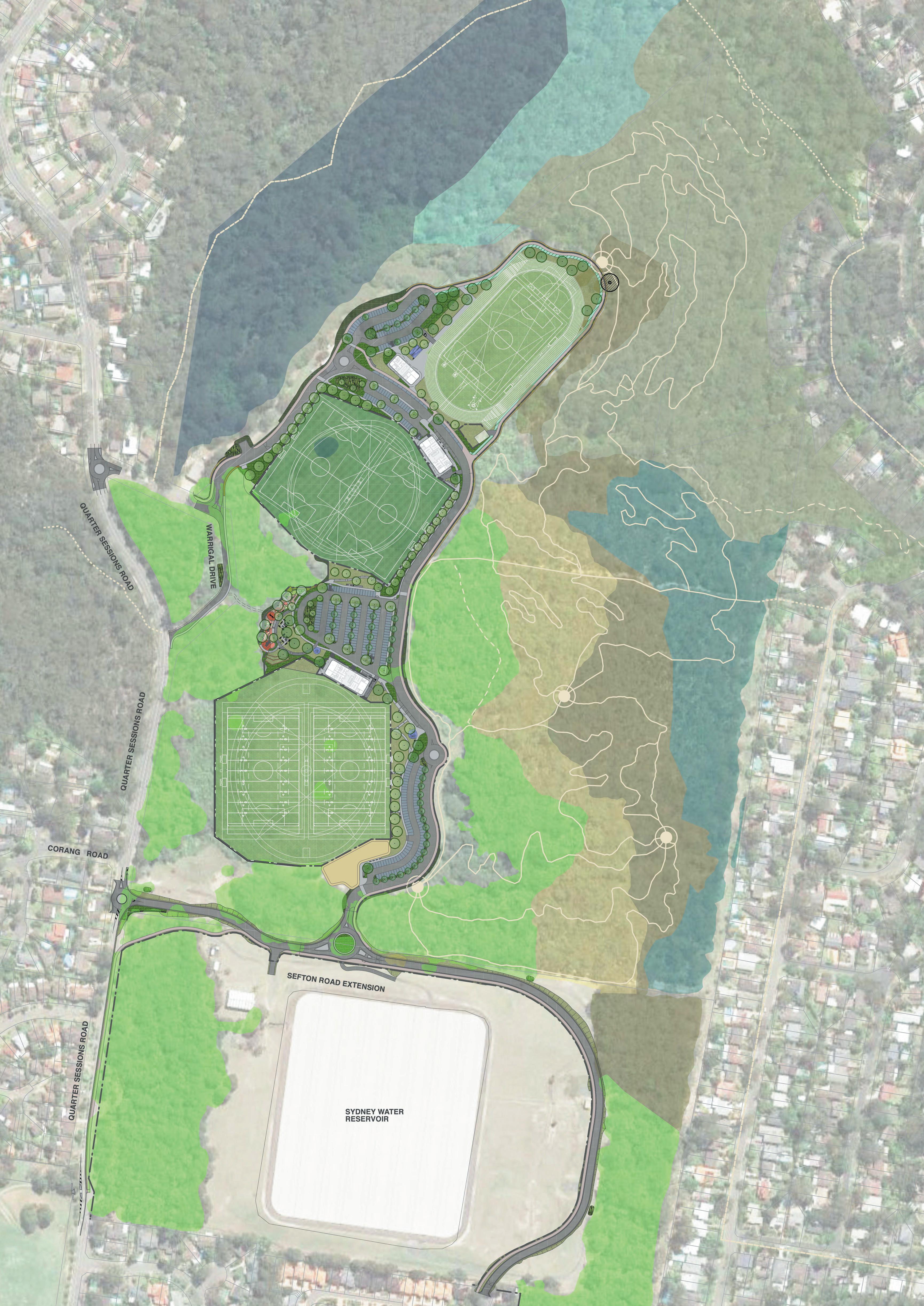
A Conceptual Master Plan has been prepared by Council for Westleigh Park (refer Figure 4.5 opposite and 4.6 over page). The plan seeks to facilitate the development of the park to conserve important habitat, address district recreational needs, and remediate the site in a flexible and adaptive approach.
The key aspects of the Master Plan are outlined as below (refer to the numbered items on Figure 4.5 opposite).
4.4.1 Circulation and Parking
1. New roundabout at Warrigal Road north
This intersection is proposed to be converted into a roundabout to improve traffic flow and to better manage traffic volumes. The central island will be mountable to allow for bus movements. Consideration was also given to the requirement for firetrucks to access the Westleigh Rural Fire Brigade facility.
Associated kerb adjustments, median islands, line marking and signage would also form part of the works. The intersection of Warrigal Drive south is proposed to be converted into a one-way exit with left turn movements permitted out onto Quarter Sessions Road. Signage and line-marking is proposed to provide clear priority to Quarter Sessions Road traffic movements.
2. New road access from Quarter Sessions Road
A new vehicular access point is proposed from Quarter Sessions Road located between the southern boundary of the site, and the Sydney Water facilities. This access point was chosen to avoid sight-line issues of the option near Corang Road, and to minimise impact to the existing significant vegetation community (STIF). This access will be shared with Sydney Water to access their operational site to the south, rather than creating a duplicate access point off Quarter Sessions Road.
3. Road access to Sefton Road
A managed road connection and additional entry to the site is proposed from Sefton Road to better balance traffic loads at selected times. This will require roadworks to continue Sefton Road through (and to) the Sydney Water site and into the Park. The management of the road will include controlled / limited opening to limit impacts on local roads and optimise benefits.
To avoid potential impacts on the existing Sydney Water reservoir’s infrastructure, the new extension is proposed to be generally on or slightly above existing grade, minimising fill embankments but avoiding any disturbance of Sydney Water dam walling. The corridor would be provided with security fencing to limit public access to the Sydney Water site.
This proposal requires ongoing discussions with Sydney Water.
4. Parking areas
It is proposed to provide off street parking to service the sports facilities within the Westleigh Park site. The Master Plan aims to provide 379 car parking spaces. These are distributed between the main field platforms and have been predominantly provided as off-road parking areas with some additional parallel spaces between the central fields and northern athletics field. Each parking area includes a number of accessible parking spaces.
5. Shared pedestrian and cycle path
The pedestrian and cycle access network to and within the site is illustrated on Figure 4.2 and 4.3.
Pedestrian access into the park is focused on a 2.5–3m shared recreational and maintenance path network which enters the site from Warrigal Drive and the proposed new entry from the south. This will provide loop access around the perimeter of the facilities in addition to providing supplementary maintenance access. The shared path will be supplemented by pedestrian paths in the centre of the site which connect parking areas to facilities and provide access through the central parkland area between the southern and central fields. The shared path will connect to a broader local network of cycle paths via both on road and off-road links. The adjoining mountain bike trails and bush walking tracks being considered will also be connected to track and trail networks beyond the site.
6. Access points to adjoining natural areas
The proposed mountain bike (MTB) trail network would be accessed through Westleigh Park where riders can use parking and other facilities, or cycle to the site and access the MTB trail entry points via shared paths or the internal road network. The primary access point (trail head) is proposed to the south-eastern edge of the park reached via the shared path or perimeter road. Other access/exit points are also been considered from the shared path to the north of the site. Access and exit is also being considered to Wareemba Avenue and the Dog Pound Creek fire/maintenance trail.
4.4.2 Active Recreation
The Concept Master Plan proposes three sports facility platforms that have been sited to integrate within the constraints of existing bushland vegetation and provision of road access.
From south to north, the field platforms step down the site executing a level change of around 8m overall. Each of the platforms is served by off street parking areas which have direct accessible connections to field and associated amenities/ facilities. The field platforms are also connected by the shared pedestrian cycle path network and supplementary pedestrian path network.
WESTLEIGH PARK – DRAFT PLAN OF MANAGEMENT February 2023 34
Note: For numbered items on this map, please refer the key aspects of the Master Plan outlined on page 34 and 37
WESTLEIGH PARK – DRAFT PLAN OF MANAGEMENT February 2023 35 1 3 5 7 10 10 14 2 8 9 13 4 6 6 10 19 19 19 12 15 15 15 17 6 6 11 4 4 17 5 16 4
4.5: Master
context MTB trail network as resolved through ongoing planning Preferred location for potential Pump Track facility 5 5 5 14 14 15 17 16 16 16 16 5 18 18 11 Proposed maintenance compound
Figure
Plan
Note: For numbered items on this map, please refer the key aspects of the Master Plan outlined on page 34 and 37
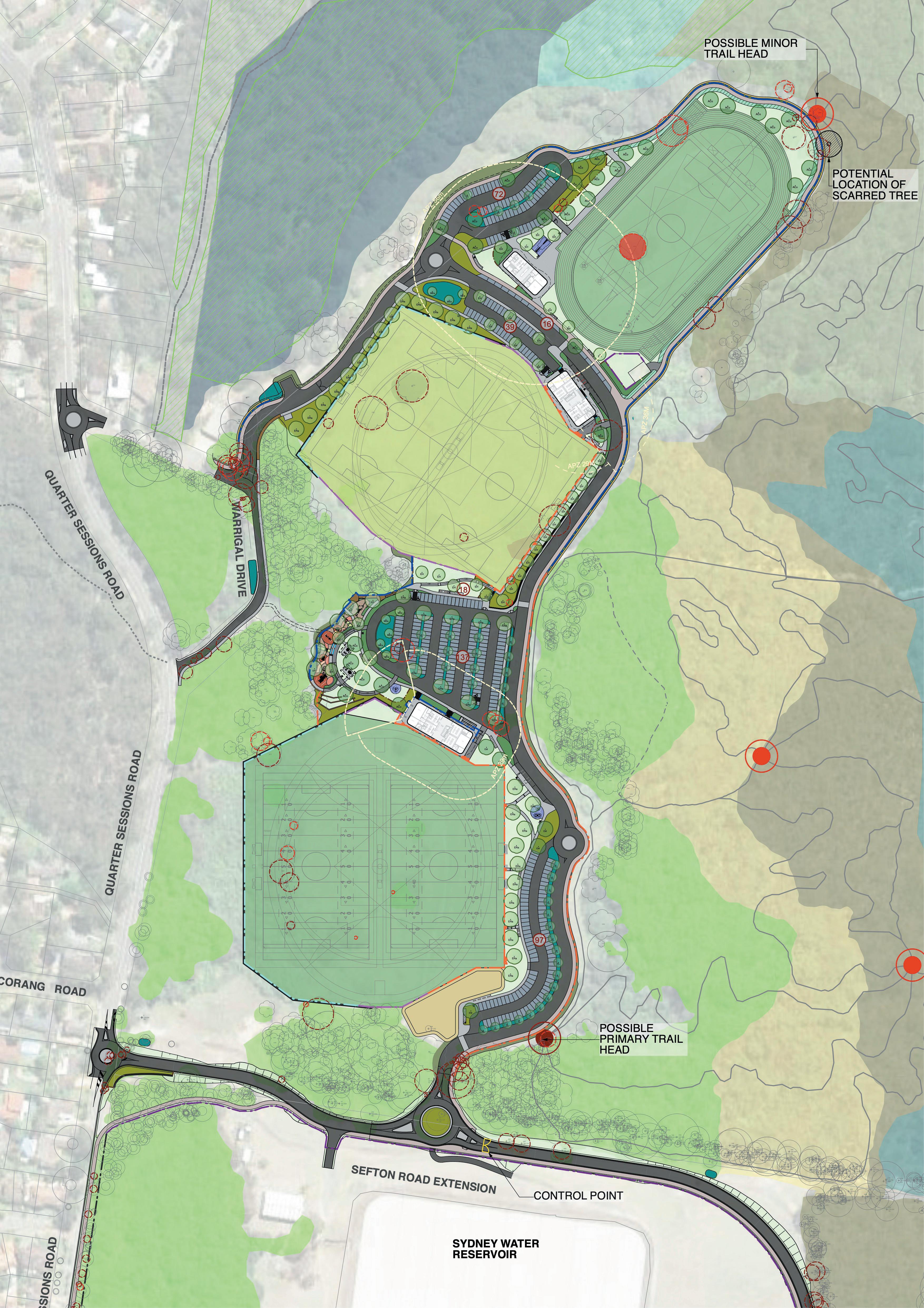
WESTLEIGH PARK – DRAFT PLAN OF MANAGEMENT February 2023 36 3 5 7 10 14 16 2 8 9 4 5 6 10 19 19 19 12 13 15 15 17 6 11 4 4 10 4 13 17 16 16 16 1 5
9 14 15 15 15 5 6 5 17 17 16 16 Proposed maintenance compound 18 18 5 Preferred location for potential Pump Track facility
Figure 4.6: Master Plan detail
7. Southern multi-purpose natural turf sportsfield platform - full senior size
The southern field platform provides the widest area working within the zone defined by adjoining bushland. The Concept Master Plan illustrates a multipurpose playing field platform accommodating two (2) full competition size football fields, or two (2) full-size Rugby fields, or a full-size AFL field, with a full-size cricket field during summer.
The field platform sits above adjoining levels and is flanked by retaining walls of varying heights to the west, Black coloured perimeter fencing again prevents balls leaving the fields and entering the bushland area.
8.
Central multi-purpose sportsfield platform
The central multipurpose field platform sits above adjoining levels to the west and is flanked by retaining walls of varying heights along with discrete ball fencing to retain balls within the fields. To the east, the platform is recessed into the landform. This central facility could accommodate a synthetic surface or alternatively be developed as a natural sports turf surface.
The available space in this zone will limit field sizes to dimensions between minimum and maximum sizes for senior competition.
9. Athletics Track and support facilities
The north platform, in the narrowest section of the cleared lands, can support a senior competition athletics track and internal field area (which could be used as a fifth football field if not being used for athletics).
The area can accommodate a line marked grass track or alternatively be developed as an all-weather athletics facility. The internal field areas are proposed to accommodate other field events e.g. shot put, long jump, high jump, discus etc.
10. Multi purpose park amenities buildings
Each of the field platforms is served by an amenities building at the same level as the field. The amenities buildings are accessed off the main carparks or the internal road network.
All the amenities buildings will be designed to reduce operational carbon emissions, conserve potable water and harvest rain water.
11. Natural Areas
An un-authorised mountain bike trail network currently dominates the natural area. Consideration of varied and shared sustainable uses of the natural area is undergoing detailed review.
A range of uses within the natural area may include walking tracks, interpretive signage, mountain bike trails and accessible paths. All uses must be ecologically sustainable and provide for the ongoing conservation of ecological values on the site.
12. Play Space
Between the southern and central field platforms is a passive recreational area that includes a play space area
that is integrated into the level changes in this area, with the surrounding bushland as backdrop. The play space could provide a local play facility in accordance with Council’s Play Plan 2019.
4.4.3 Informal Recreation
13. Grassed viewing areas
Along the edge of each sport field, shaded grassed sections provide warm up areas and spectator viewing.
14. Open grassed informal games and picnic parkland
An open grassed space with seating and shelter provides for both local use and complements the sports uses of the fields. This area also provides a buffer zone for the playground from the carpark.
4.4.4 Environment
15. WSUD water quality rain gardens
Water Sensitive Urban Design (WSUD) zones will be provided all of the impervious areas, including off street parking and roads to treat runoff and manage flows before it enters the local creek system.
16. Existing TEC bushland protection areas
The cleared area of the site is adjoined by several vegetation communities including the Sydney Turpentine Ironbark Forest (STIF) which is listed as Critically Endangered under the EPBC Act and an CEEC under the BC Act.
The natural areas also support several threatened flora species and provides habitat for threatened fauna species. Future development of the cleared areas, including the long term operational phase, must seek to limit impacts (direct and indirect) on natural areas. Bushland areas will be managed in accordance with Council’s general policies for natural area management.
17.
Restoration of bushland
Vegetation condition across the site is varied due to historical uses and impacts. Exotic species are readily spread as garden escapees and along watercourses and interfaces with open spaces. Due to the high conservation values of the ecological communities present on site, bushland restoration works will be undertaken to improve the condition of these communities to support their longevity.
18. Scarred Tree conservation
The identified scar tree to be relocated and conserved and interpreted in accordance with ACHAR and ongoing input from Aboriginal stakeholders (an indicative location is shown on the maps in this PoM).
19. Environmental sustainability
Environmentally sustainable design features will be included in the buildings to reduce embedded and operational carbon emissions, such as passive solar design, renewable energy and energy efficient hot water and lighting.
WESTLEIGH PARK – DRAFT PLAN OF MANAGEMENT February 2023 37
4.5 Staged Implementation of the Master Plan
Delivery of the Master Plan will be staged as funding becomes available, see Figure 4.7.
It is noted that around 40–50% of the cleared portion of the site is proposed to be excavated to natural ground with the landfill material redistributed beneath filled areas.
The final boundary of the stage one area would be based on the detailed volumes of contaminated material yeilded from stage 1 earthworks to be contained and capped, but would generally reflect Figure 4.7.
Stage 1 works would mainly include the southern multi-purpose natural turf sportsfield platform and its amenities, the carpark to the east, the new entry from Quarter Sessions Road along the southern boundary of the site, and the southern portion of internal park road linking to the amenities and the MTB trails. The existing unsanctioned mountain trails will be either upgraded and improved or closed and rehabilitated. Some new trails and a primary trail head will be constructed to facilitate connections and circulation around the network.
The associated utilities would also be required to support the stage 1 works, including electrical substation kiosk, and water and sewer connections. Stage 1 works would include the proposed Sefton Road extension linking the park to Sefton Road for specific controlled use, but not providing a day to day through access.
Stage 2 works will be the remaining construction, including the northern and middle platform, the playground and BBQ/picnic area and associated carparks, amenities and utilities, along with the internal road networks and the upgrade of Warrigal Drive, and the Quarter Sessions Road / Warrigal Drive intersection.
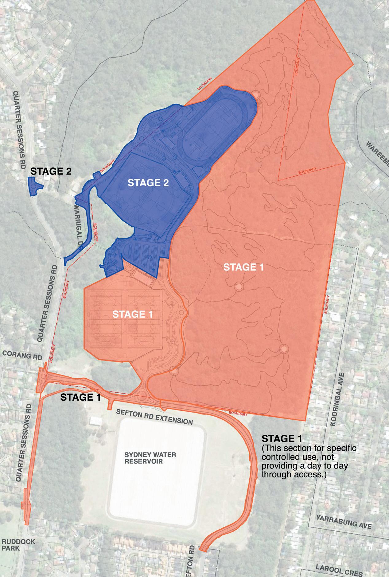
WESTLEIGH PARK – DRAFT PLAN OF MANAGEMENT February 2023 38
Figure 4.7: Indicative staging options
4.6 Scale and Intensity of Use and/ or Development
4.6.1 Sportsground Facilities
Sportsground facilities in Westleigh Park are taken to include those occurring within land categorised as ‘Sportsground’ that may include:
• Sportsfields
• Athletics Track and support field facilities
• Site services and infrastructure
• Access roads and parking
• Pedestrian and cycle paths
• Play space facilities
• Supporting grassed parklands
This plan envisages a level of organised sports and sports ground areas comparable to Pennant Hills Park. Potential development of the Athletics facility ranges form a linemarked grass track through to an all weather elite athletics facility.

Field use would be subject to regular bookings or seasonal hire agreements that are subject to renewal each season.
Council would consider other bookings across the seasons for weekly or weekend use that don’t clash with seasonal hire on an individual basis subject to ground condition and other factors.
4.6.2 General Community Use Facilities
The amenities facilities would be managed similarly to other sports grounds through a seasonal hire subject to renewal each season. Shared and general community use of buildings on site for a range of community purposes is anticipated.
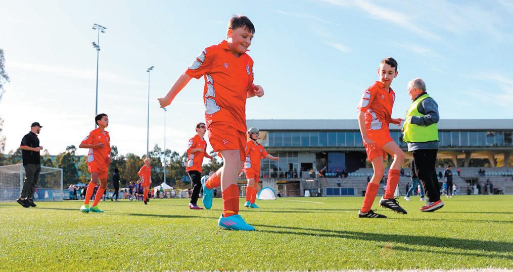
Example images:
1. The multipurpose field platforms can cater for all football codes including AFL
2. The Master Plan caters for a linemarked track or an all weather athletics facility subject to needs
3. In the central parkland area play facilities and informal use parklands will be provided
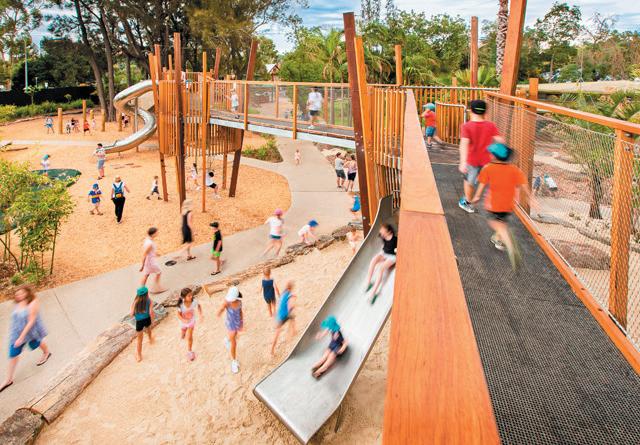
4. Council proposes to sustainably control and manage MTB access through bushland areas in Hornsby
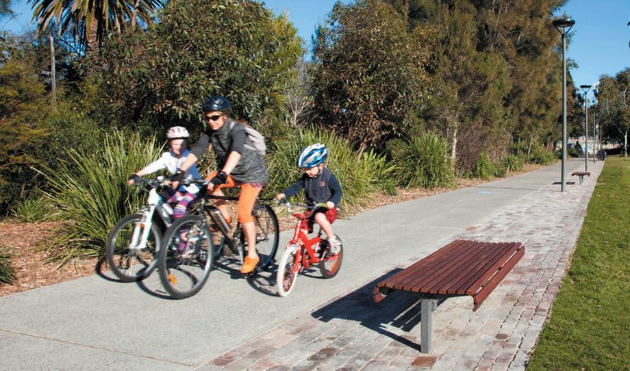
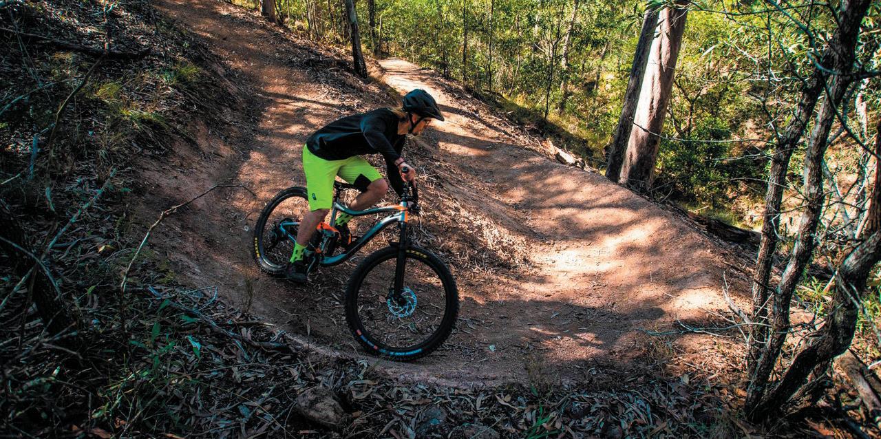
5. Shared paths and supporting pedestrian paths provide for access and recreation / fitness
Source: Google
WESTLEIGH PARK – DRAFT PLAN OF MANAGEMENT February 2023 39
1 2 3 4 5
Works areas outside cadastral boundary and on adjoining Council lands subject to the applicable PoM. (Generic Plan of Management - Planning District Two)
Works areas outside cadastral boundary and on Operational Land
Works areas outside cadastral boundary and on Operational Land
LEGEND
PLANT COMMUNITY TYPES
Vegetation: Sydney Turpentine - Ironbark
S ydney TurpentineIronbark (good)
S ydney TurpentineIronbark (moderate)
S ydney TurpentineIronbark (weedy)
Vegetation: Peppermint-Angophora Forest
Works areas outside cadastral boundary and on adjoining Council lands subject to the applicable PoM. (Generic Plan of Management - Planning District Two)
S ydney Coastal S andstone Gully Forest (good)
S ydney Coastal S andstone Gully Forest (moderate)
S ydney Coastal S andstone Gully Forest (weedy)
S ydney Coasta S andstone Gully Forest (wet)
Vegetation: Scribbly Gum Open-woodland/Heath
S ydney Hinterland Dwarf Apple Low Woodland (good)
S ydney Hinterland Dwarf Apple Low Woodland (weedy)
Vegetation: Bloodwood-Scribbly Gum
Woodland
Woronora Plateau S cribb y Gum Woodland (good)
Woronora Plateau S cribb y Gum Woodland (weedy)
Vegetation: Smooth-barked AppleBlackbutt - R ed Bloodwood open forest in enriched sandstone gullies of the western Woronora plateau
S ydney H nterland Apple - Blackbutt Gully Forest (good)
S ydney Hinterland Apple - Blackbutt Gully Forest (weedy)
Vegetation: Blue Gum High Forest
Blue Gum High Forest (good)
Blue Gum High Forest (weedy)
Vegetation: Typha
Typha (Disturbed)
Vegetation: Smooth-barked Apple - R ed Bloodwood - Blackbutt tall open forest on shale sandstone transition soils in eastern Sydney
S ydney Coasta S haleS andstone Forest (good)
Vegetation: Others
Exotic
P anted nat ve
BioBanking
Works areas outside cadastral boundary and on adjoining Sydney Water Lands - owners compliance and consent required
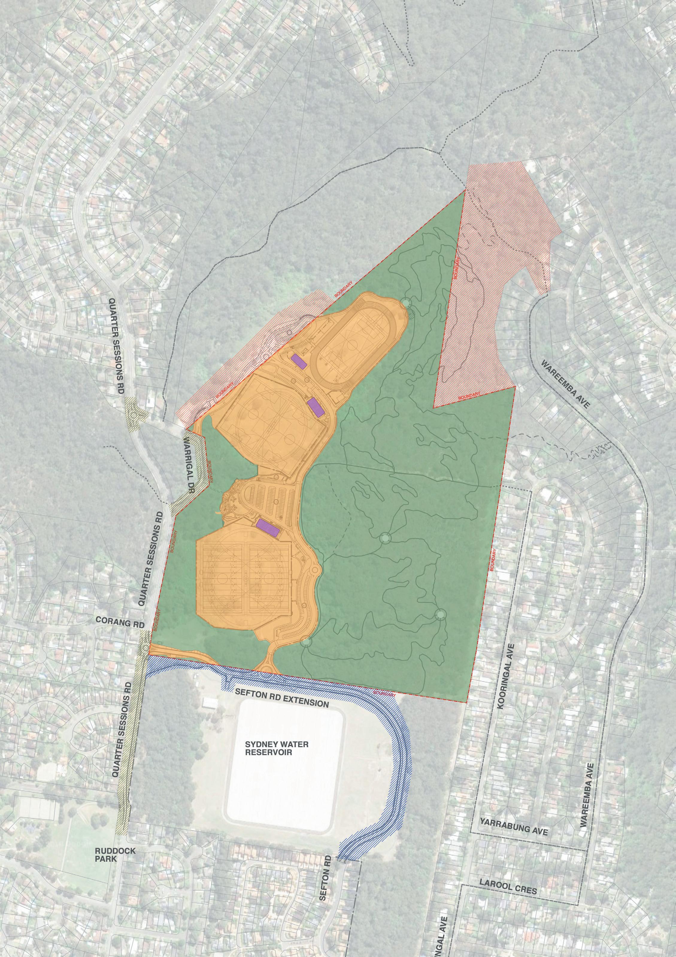
WESTLEIGH PARK – DRAFT PLAN OF MANAGEMENT February 2023 40
Figure 5.1: Categorisation
ACCESSIBLE PAR KING & KISS & DR OP ACCESSIBLE PAR KING & KISS & DR OP LEGEND Natura Area - Bushland S portsground General Community Use CATEGOR ISATION LEGEND S ewer pipe Water pipe SERVICES Electrical in ground condu t
LEGEND Proposed S hared path2 5m width Pedestrian crossing/ refuge crossing - to be determined Potential refuge cross ng - to be confirmed Major pedestrian entry S econdary pedestrian entry Existing shared path SHAR ED PATH Proposed accessible shared path - 2 5m width PEDESTR IAN Proposed accessib e pedestrian path - 1 8m w dth CR OSSING ENTRY Proposed pedestrian path with steps - 1 8m w dth PEDESTR IAN ACCESS AND WALKING LEGEND Proposed S hared path2 5m width Pedestrian crossing/ refuge crossing - to be determined Potential refuge crossing - to be confirmed Major pedestrian entry S econdary pedestrian entry Existing shared path Proposed on-road cycle route Existing on-road cycle route SHAR ED PATH Proposed accessible shared path - 2 5m width CYCLE CR OSSING ENTRY Potential pump track CYCLE ACCESS S ydney Coastal S andstone Bloodwood S hrub Forest BioBanking EXISTING VEGETATION COMMUNITY B ue Gum Diatreme Forest S ydney Coastal S andstone Gully Forest S ydney Turpentine-Ironbark Forest S ydney Hinterland Apple-Blackbutt Gully Forest S ydney Hinterland Dwarf Apple Low Woodland Duffy s Forest Typha Exotic Exotic Grasslands Proposed MTB trailsEasy TR ACK NETWOR K Existing managed walking tracks Existing fire trail connection Optional MTB connection on road or verge ProposedMTB trailsIntermediate Proposed MTB trailsHard S hared trails Walking tracks Track Hubs - primary mountain bike trail head Track Hubs
5.0 Categorisation
5.1 Explanation of Categorisation Mapping
For the purposes of this Plan of Management (PoM), it is necessary to assign a categorisation of land which is mapped on Figure 5.1. This reflects Councils’ proposed use of the community land for Westleigh Park, in accordance with the Local Government Act 1993, Division 2 - Use and Management of Community Land.
The Master Plan (Figures 4.5 and 4.6) provides an illustration of an intended arrangement of facilities in Westleigh Park, which includes the development of sportsfields, athletics track and support field facilities, amenities buildings, site services and infrastructure, access roads and parking, pedestrian and cycle paths, play space facilities and supporting informal parklands.
The proposed recreation facilities are contained within appropriately categorised areas for future management.
The adoption of this PoM will legislatively enable appropriate development works to be carried out within the various categorisation zones. Adoption would also require commitment to management of the lands in Westleigh Park in accordance with the objectives outlined in the Action Plan forming Part 2 of this PoM.
5.2 Land categorised as ‘Sportsground’
The perimeter of the southern, central and northern sports field platforms and their supporting zones comprise the areas proposed to be categorised as ‘Sportsground’ on the Categorisation Map opposite. This comprises the previously cleared zone of the site which was subject to the various landuses over time as outlined in section 3.3.
5.2 Land categorised as “Natural Area (Bushland)”
The lands categorised as ‘Natural Area (Bushland)’ comprise the remnant and regenerating bushland areas beyond the previously cleared central zone of the site. As identified in the 2016 site investigations and supplemented by the Eco Logical Australia as part of the Concept Master Plan, the bushland areas include Critically Endangered Ecological Communities under the EPBC Act and an Endangered Ecological Community under the BC Act.
The adjoining bushland known as the “Dog Pound Creek” to the north west of the site is largely the subject of a BioBanking Agreement. The Dog Pound Creek BioBanking area is addressed by a separate Generic PoM for Community Land and Crown Reserves (Planning District 2).
5.3 Land categorised as ‘General Community Use’
The areas defined as General Community Use relate to the indicative proposed zones of buildings to serve recreational and general community use including sports, informal recreation and community activities.
Use of the buildings will be subject to Council’s evaluation of sporting and community needs and booking arrangements determined for the fields. Council may enter a licence or lease for ongoing use of amenities buildings by user associations or clubs or other community groups.
WESTLEIGH PARK – DRAFT PLAN OF MANAGEMENT February 2023 41
6.0 Operational Proposals
6.1 Maintenance
Council will be responsible for maintenance of Westleigh Park to a standard that responds to the requirements outlined in this PoM. Part 2 - Action Plan identifies a specific maintenance approach that will be adopted for the upkeep of the asset. Council utilises Council staff, contractors and voluntary resources to assist in meeting the targets identified.
6.2 Leases and Licences
Pursuant to the provisions of Section 46 Parts (1)(b), (2), (4)(a) and (5) of the Local Government Act 1993, Council may lease or license Community Land in a PoM for purposes that are also consistent with the land categorisation and with this PoM.
The Local Government Act requires that all grants of all estates and any lease or licence of Community Land is expressly authorised by a PoM. In accordance with the Act, this PoM expressly authorises leasing and licensing which formalises the use of Community Land by groups, commercial organisations and/or individuals providing facilities or services for public use that is also in accordance with the core objectives for the category of Community Land and objectives of this PoM.
Activities must be compatible with the category of the reserve and provide benefits, services or facilities for users of the land. The terms and conditions of a lease should ensure property management and maintenance, and that the interests of Council and the public are protected.
A lease is generally required where exclusive control of all or part of an area by a party is proposed or desirable in the interest of management of the area. A licence is generally required where intermittent or short-term occupation or control of all or part of an area is proposed. A number of licences can apply at the same time provided there is no conflict of interest.
The maximum allowable period for leases/licences on Community Land under the Local Government Act 1993 is currently a maximum of 30 years for purposes consistent with the categorisation and core objectives of the particular area of Community Land. Community Land may only be leased or licensed if public notice is given, unless exempted under the Local Government Act 1993.
A lease, licence or other estate may be granted for the provision of public utilities and works associated with or
ancillary to public utilities, or may be granted, in accordance with an express authorisation in a PoM.
Future Uses
When current leases expire, Council should reassess the lease and licensing arrangements. Issues to be considered when reassessing leases or entering into new agreements include:
Ensuring all leases and licences are based on a sound asset management basis with rents and charges having regard to market values and other social and economic factors.
Ensuring all leases and licences meet the requirements of relevant State and Local Government Acts and Council town planning controls.
Ensuring proposed activities are compatible with the core objectives established in the Local Government Act.
Negotiating greater financial returns which will contribute to management and maintenance of Community Land.
Requiring the lessee to carry out improvement works to the leased facility.
All future lease / licence arrangements entered into shall be in accordance with Council’s Policies CSISAS 12 – Delegation of Authority to Grant Lease / Licence Agreements, CSISAS 13-Use of Council Buildings by Kindergartens and CSISAS 14 - Lease/Licence of Council Land and in accordance with requirements of the Local Government Act 1993.
Council Policy CSISAS 14 states that the maximum length of lease/licence of Council land will generally be five (5) years. Council may however give consideration to granting an additional period of tenure where special circumstances warrant this occurring.
Where a lease arrangement has been entered into with Council for Community Land, subleasing of the land must be in accordance with the requirements of section 47C of the Local Government Act 1993.
WESTLEIGH PARK – DRAFT PLAN OF MANAGEMENT February 2023 42
This PoM authorises the following types of leases and licences for Community Land within Westleigh Park:
6.2.1 Leasing and Licensing of Sports Facilities
The granting of leases/licences are expressly authorised for use of sportsgrounds for activities permissible under this PoM, the Hornsby Shire Local Environment Plan 1994, the Local Government Act 1993 and pursuant to Development Consent if required. The following types of sports facility licences will be granted for the exclusive use of sportsgrounds (including playing fields, change rooms, and canteen) or courts (including netball, basketball and/or tennis courts) at nominated times.
Licences and Leases for Sportsgrounds
The granting of leases or licences is expressly authorised by this PoM as required for sports that run on either a summer (September to March) or a winter (March to September) competition basis, or competitions/ sports programs that continue through the year, and possibly from year to year for a period of up to 21 years.
The range of sports possible include but is not restricted to, clubs and associations engaged in Australian Rules Football, Rugby League or Rugby Union Football, Soccer, Baseball, Softball, T Ball, Cricket, Athletics, Touch Football, Hockey, Basketball and Tennis, cycling, mountain bike trail riding,orienteering, and training in all these sports.
Leasing or licensing for the operation of restaurants, cafes, canteens, kiosks or other food outlets are also expressly authorised for a period of up to 21 years.
Licences may cover competition/program events on Saturdays, Sundays and public holidays (after 8am) and Friday and Saturday evenings (twilight events in summer).
Licences may also cover training Monday to Friday including some during daylight hours, but predominantly for training from 5pm to 10pm. During these times of use the club or association will have exclusive use of the sportsground.
Licences will generally be granted for periods of a single sports season or a year, renewable annually or as deemed appropriate by Council. In some circumstances leases or licences may be granted for periods of more than a year and up to 21 years (with the consent of the relevant Minister and where stipulated in legislation), particularly where a hirer has invested in capital improvements at a park. Such a lease or licence may cover an entire building or identified facilities and buildings within a park.
To manage ground wear and tear and maintain the use of grounds use within carrying capacity and to meet the needs of Hornsby Shire residents, limits of use will be placed on the allocation of sportsgrounds. In such cases preference in the allocation of sportsgrounds will be given to hirers based in Hornsby Shire.
Licences for School Use of Sportsgrounds
The granting of licences are expressly authorised by this PoM for Schools for the exclusive use of sports facilities at times during weekdays. The range of sports permissible may include but will not be limited to Australian Rules Football, Rugby League or Rugby Union Football, Soccer, Baseball, Softball, T Ball, Cricket, Athletics, Touch Football, Hockey, Basketball and Tennis.
Licences for Casual Hire of Sportsgrounds
The granting of licences is expressly authorised by this PoM for casual events including, but not limited to, the playing of Australian Rules Football, Rugby League or Rugby Union Football, Soccer, Baseball, Softball, T Ball, Cricket, Athletics, Touch Football, Hockey, Basketball and Tennis; for community events including organised fetes, festivals, parades and performances that may include stall holders engaging in a trade or business; and small-scale private sector events including markets, promotional events, parties, weddings, filming, photography and personal training.
These events may generally be held between the hours of 8am and 10pm. Specific approval will be required to licence events proposed outside these hours. Leasing or licensing for the operation of restaurants, cafes, canteens, kiosks or other food outlets are also expressly authorised for a period of up to 21 years.
6.2.2 Licences for Special Events
Licences are expressly authorised by this PoM for the staging of special events such as fetes, festivals, fairs, circuses, markets, musicals, theatre, movies, fun runs, art exhibitions, charity or community fundraising performances or events, gala sports carnivals, community carol singing, large picnics, family reunions, private ceremonies, cultural or religious ceremonies, weddings, community education events, pet and animal events, miscellaneous community events, and small scale private sector events such as promotional events, musical or drama performances, art exhibitions, parties, filming and photography.
WESTLEIGH PARK – DRAFT PLAN OF MANAGEMENT February 2023 43
6.2.3 Leasing and Licensing of sportsground or park Facilities for varied uses
The granting of licences is expressly authorised by this PoM for use of certain parks or a portion of those parks for occasional hire. Activities subject to lease or licence may include but will not be limited to community groups using designated parks or a portion of those parks for regular market days, model boat / plane activities, community fund-raising events that may include stallholders engaging in a trade or business, private sector events including markets, recreation events such as cross country runs or mountain bike events, promotional events, parties, filming and photography permissible under the Hornsby Shire Local Environment Plan 2013, and other uses permitted under this PoM. These events may generally be held between the hours of 8am and 10pm, with consideration given by Council to the frequency, scale and intensity of events on each occasion. Specific approval will be required to licence events proposed outside these hours, and in consideration of limits to neighbourhood disturbance.
Leasing and licences for restaurants, cafes, canteens, kiosks or other food outlets
This PoM expressly authorises leases and licences for the operation of restaurants, cafes, canteens, kiosks or other food outlets, for periods up to 21 years, or 30 years with State Government ministerial support.
6.2.4 Leasing and Licensing in Natural Areas
Buildings in bushland are used by community groups such as scouts, girl guides and sporting clubs associated with natural area values. The leasing of buildings in bushland in community open space are to be considered on individual merits and may be granted by Council for a period not exceeding 21 years, or 30 years with State Government ministerial support. Public notice will be given if the Council proposes to grant a lease or licence for a period exceeding five years or for five years or less for a use not exempted by the regulations. With respect to Natural Areas, a lease or licence may be granted for the erection or use of the following items pursuant to Development Consent:
Walkways, pathways, bridges, tracks;
Causeways;
Observation platforms; and
Signs.
A lease or licence may also be granted for the purposes of:
Information kiosks, refreshment kiosks (but not restaurants);
Work sheds or storage sheds required in connection with the maintenance of the land; and
Toilets or restrooms.
6.2.5 Other Leases and Licences Crossing of Reserves
Section 46 of the Local Government Act prevents Councils from granting leases, licences or other estates over Community Land for private purposes except in the uses described in Section 116 (3 - 5) of the Local Government (General) Regulation 2005. Short term, casual use will only be granted for a purpose consistent with the core objectives for the category of land and for a purpose referred to in section 46 (4) (a) (i) (ii) of the Local Government Act for:
“(a) The provision of goods, services and facilities, and the carrying out of activities, appropriate to current and future needs within the local community and of the wider public in relation to any of the following:
i. public recreation;
ii. the physical, cultural, social and intellectual welfare or development of persons.”
Such licences are expressly authorised by this PoM.
WESTLEIGH PARK – DRAFT PLAN OF MANAGEMENT February 2023 44
Easements and reservations
In accordance with the requirements of the Local Government Act 1993, this plan expressly authorises Council to grant easements for authorities, organisations or individuals in favour of private lands over lands identified in this PoM, providing Council is satisfied there is no reasonable alternative and that appropriate benefits are obtained for the Community Land. Any adverse impacts on playing surface or drainage is to be remediated at the cost of the holder of the easement. Council will not be responsible for any loss or damage caused through any act or omission of Council to any structures or facilities within the easement.
As indicated on Figure 6.1 on the next page there are no easements applying to the Westleigh park site currently.
Liquor Licences
Although granting of liquor licences are subject to other approvals and are not at the sole discretion of Council, this PoM allows for Council to give permission as the landowner for liquor licences on Community Land subject to other necessary approvals. Applications for liquor licences will be considered on individual merits and will only be considered when Council is satisfied that the licensee can meet legislative requirements for responsible service of alcohol. Such licences are expressly authorised by this PoM.
Casual Liquor Licences
The consumption of alcohol in reserves under the care, control and management of Hornsby Shire Council are expressly authorised by this PoM but only with written Council consent under the following conditions:
People will not be allowed to enter or remain in reserves in an intoxicated state;
People will not be permitted to consume alcohol in reserves while junior games are in progress; and
People will not be permitted to consume alcohol within 10 metres of children’s play areas.
The ‘Park Rules’ Notice contained in the Appendix allows for this.
Granting of Estates
This PoM allows Council to grant ‘an estate’ over Community Land for the provision of public utilities and works associated with or ancillary to public utilities in accordance with the Local Government Act 1993. Estates may also be granted across Community Land for ‘the provision of pipes, conduits or other connections under the surface of the ground for the connection of premises adjoining the Community Land to a facility of the Council or other public utility provider that is situated on the Community Land. Estates will be granted in accordance with the requirements of the Local Government Act 1993. An estate in respect of Community Land is authorised by this PoM for the purpose of a ‘public road’ are expressly authorised by this PoM under the following conditions (S.47F):
Where the provision of that road is consistent with the core objectives.
Where that road is necessary to facilitate enjoyment of the land or any facility on that land.
Where other means of access other than public road access have been considered.
Public Utilities
This PoM expressly authorises Council to enter into leases, licenses or other forms of agreement with relevant authorities, organisations or individuals in relation to the provision of services or utilities for a public purpose.
Remediation and earthworks to establish a park
This PoM foreshadows the excavation and regrading of the cleared area that has been subject to past landuses and requires capping to address contamination issues. Remediation will also require importation of environmental and landscape materials to facilitate the capping and parkland finishes. The PoM authorises the granting of a lease, license or other estate over the necessary portions of Community Land (excluding Natural Areas) covered by this PoM for the purpose of importing materials required for remediation and park development. Planning approvals for such work will be determined by Council as required.
A lease, licence or other estate will be pursuant to Section 46(1)(b)(ii) of the Local Government Act 1993. The lease, license or other estate will be for purposes prescribed by sections 36F and 36G of the Local Government Act 1993 for Community Land categorised as a Sportsground. The lease, license or other estate will be for a period of less than five years.
WESTLEIGH PARK – DRAFT PLAN OF MANAGEMENT February 2023 45
WESTLEIGH PARK – DRAFT PLAN OF MANAGEMENT February 2023 46
Sydney Water Site
WESTLEIGH PARK – DRAFT PLAN OF MANAGEMENT February 2023 47
Westleigh Park
Figure 6.1: Existing Easements
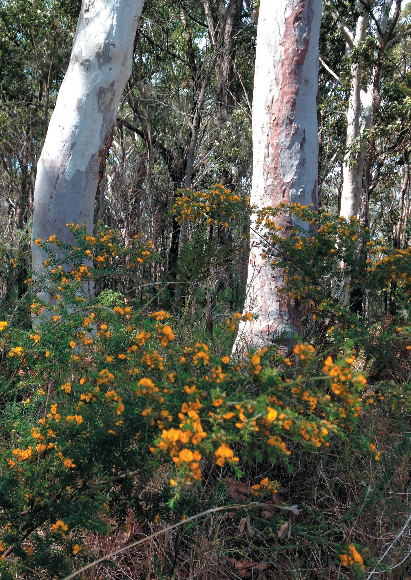
48
Pultenaea villosa in flower in Westleigh Park bushland
WESTLEIGH PARK – DRAFT PLAN OF MANAGEMENT February 2023
(source: Hornsby Council)
Part 2
7.0 Action Plans
The Action Plan has been developed to support management goals for the proposed developments of Westleigh Park. It provides statements on how objectives and performance targets will be implemented and outcomes managed into the future. Following are definitions of the terms used in the Action Plan:
‘Management Statement’ indicates how the objectives of the PoM will be addressed and implemented and what users and the general public may expect in the provision of the service in Westleigh Park.
‘Actions’ are the specific statements that elaborate on the strategy contained in the Management Statement.
‘Management Team (Mgt Team)’ provides which team within Council will have primary responsibility for the Action.
These are abbreviated as below:
HSC: Various Hornsby Council
MC: Management Committees
MCC: Manager Corporate and Community
MCS: Manager Community Services
MAOM: Manager, Asset Operations and Maintenance
MF: Manager Financial Services
MHR: Manager Human Resources
MPR: Manager Parks, Trees and Recreation
MRI: Manager Risk and Insurance
MSP: Manager Strategic Planning
MTRS: Manager Traffic and Road Safety
MNR: Manager Natural Resources
MWM: Manager Waste Management
NL: Neighbouring Landholders
P: Proponent
PAT: Parks Asset Team
PSU: Parks Service Unit
RFS: Rural Fire Service
SU: Sportsground Users
7.1 Time Frame
Definitions of timing for actions are as follows:
S (Short Term) Action completed within 2 years
M (Medium Term) Action completed within 2 - 4 years
L (Long Term) Action commenced after 4 years
O (Ongoing) Action carried out on a regular basis for the term of this Plan of Management
7.2 Performance Measures
Performance Measure are how Council knows what progress is being made relative to the time frame established for the actions, or whether the final achievement is realised. This section of the Plan will require review to ensure it is an effective working document. It will provide a framework for management consistent with anticipated availability of resources and anticipated community needs.
7.3 Environmental Factors
The Action Plan contains elements that address the need to assess the environmental impacts of an activity. Measures to minimise such impacts are contained in the Action Plan. The timing determined for improvements will be subject to the availability of funds and will require revision if circumstances alter.
7.4 Assessment
Assessment of targets will take place in reviews of the Action Plan at intervals of between five to ten years. Monitoring of actions within this Plan of Management will occur on an annual basis. Assessment will include qualitative and quantitative reviews of targets.
WESTLEIGH PARK – DRAFT PLAN OF MANAGEMENT February 2023 49
8.0 Action Plan for all Categories of Community Land
8.1 Operating Standards
8.1A Environmental Sustainability
Ensure the adjoining land uses minimise impacts on the natural environment.
Ensure that active uses of Council or Crown land have a minimum impact on bushland.
MPR
O The improved condition of core bushland and bushland interfaces and natural watercourses.
Fauna diversity and abundance maintained and improved.
8.1B Maintenance Personnel
Skilled and experienced labour is used to implement specialist works as specified in the Service Level Agreement.
Works including traffic control, pesticide applications, pruning of trees and shrubs, hedges, bush regeneration and arborcultural work is to be carried out by suitably qualified and / or trained staff.
Appropriate training is provided for staff involved in the above tasks.
8.1C Council Staff Health and Safety Standards
At all times Council employees and contractors will comply with Work Health and Safety Standards.
Train Council staff in Work Health and Safety Standards.
Maintain work practices to comply with Work Health and Safety standards.
Encourage staff to report breaches of Work Health and Safety standards to the designated WH&S officers.
MPR (PAT / PSU)
O Staff carrying out specialist maintenance works specified in the Service Level Agreement, are appropriately skilled and trained.
HSC
O Safe Work Method
Statements are regularly prepared, reviewed and communicated to staff.
Reduction in the number of incidents recorded onto Safehold (Council’s WHS management system).
WESTLEIGH PARK – DRAFT PLAN OF MANAGEMENT February 2023 50
Management Statement Action Mgt. Team Timeframe Performance Measure
8.1D Legislative Standards
Services are provided to agreed national and industry standards, SEPP Infrastructure, the HSLEP and policies and standards resultant from public consultation.
Developments are undertaken with regard to the relevant legislation.
8.1E Technical Standards
The design of any new structures on community land must comply with the relevant Australian standards.
Monitoring requirements will comply with those specified in Service Level Agreements.
Staff are up to date and familiar with the relevant legislation impacting upon the level and standard of Council services.
Awareness of SEPP (Infrastructure), HSLEP, Crown Lands Act and other important legislation is promoted with staff.
New buildings and structures comply with the relevant standards.
Work will be monitored to assess compliance with requirements specified in the Service Level Agreement.
Activities of Council uphold legislative requirements.
Business processes incorporate legislative requirements.
Staff are trained in legislative requirements.
All new buildings and structures on community land comply with the relevant building standards.
Service Level Agreement work is monitored and reports generated to reflect monitoring outcomes.
WESTLEIGH PARK – DRAFT PLAN OF MANAGEMENT February 2023 51
Action Mgt. Team Timeframe Performance Measure
Management Statement
MPR O
HSC MPR PAT / (PSU) O O
8.1F Facility development at sportsgrounds
Sportsgrounds will be developed to a standard consistent with council’s economic and budget sustainability objectives.
Sports facilities will be developed only on suitable reserves and to meet identified needs.
Sportsground development will be funded from a variety of sources.
Sportsgrounds are intended to provide primarily for suburban amateur competition level sport.
Development of elite-standard facilities will not necessarily be funded by Council however Council may allow hirers to do so.
Address standards for supporting infrastructure e.g. canteens, changerooms and storage areas.
Improved or enlarged canteens, club equipment storage areas, club meeting rooms, covered spectator areas, gymnasiums and the like are outside the responsibility of Council to provide, but may be provided where a level of co-funding is present.
MPR O Council funds are not diverted for the provision of elite-standard sports facilities and supporting infrastructure.
WESTLEIGH PARK – DRAFT PLAN OF MANAGEMENT February 2023 52
Statement Action Mgt. Team Timeframe Performance Measure
Management
8.2 Equity and Access
8.2A Disabled / Stroller Access
Provide access for disabled users and strollers onto community land where possible.
Address unsuitable access, providing access paths where appropriate and as finances allow.
Satisfy the requirements of the Disability Discrimination Act 1992 and the Anti-Discrimination Act 1977.
HSC
Disabled / stroller access is provided into appropriate areas of community land.
Requirements of the Disability Discrimination Act and AntiDiscrimination Act are met as resources and conditions allow.
WESTLEIGH PARK – DRAFT PLAN OF MANAGEMENT February 2023 53 Management Statement Action Mgt. Team Timeframe Performance Measure
Where parking areas are provided for the community on community land, provide appropriate number of parking spaces in accordance with the requirements of the Access and Mobility DCP, to allow access for users with disabilities. M O S
8.2B Equity of Access to Council Reserves and Facilities
Strive to provide equal opportunity of access to community land for all sectors of the community.
Recognise the role of community sports clubs in using Council facilities to operate sport.
Consider historical use and hiring patterns when assessing facilities for allocation.
When opportunities arise to review allocation of facilities, weighting is to be given to groups with female, disabled, non-English speaking background and other membership bases.
Organisations based in Hornsby Shire and with a high proportion of residents of the Shire shall be favoured.
Provide access to reserves and buildings within reserves for the disabled where practical.
When opportunities to redistribute allocation of Council facilities arise, the principle of satisfying the greatest demonstrated recreation or leisure need.
Implement relevant findings of the Disability Inclusion Action Plan and Play Plan as practical.
HSC O Equity of access is considered when an opportunity arises to review allocation of use of Council facilities.
WESTLEIGH PARK – DRAFT PLAN OF MANAGEMENT February 2023 54 Management Statement Action Mgt. Team Timeframe Performance Measure
8.2C
Un-authorised Camping
Camping will not be allowed in most parks except in support of a special event and with a licence or other express consent of Council.
Council recognises that all people should have access to private or public housing which meets their individual needs, and equally that all people have a right to enjoy public reserves for activities that do not impact on other users’ enjoyment.
People will be encouraged not to camp in public reserves unless in designated camping areas or otherwise use public reserves in ways that impact on access by other users.
8.3 Anti-social behaviour
8.3A Deterring anti-social behaviour
Develop and implement programs to minimise incidents of anti-social behaviour on community land.
Parks will be patrolled in order to curtail un-authorised camping.
Council will enlist appropriate support services to assist in providing alternative accommodation for homeless people in public reserves when complaints arise.
Rangers and Parks maintenance staff will patrol parks to discourage or prevent people from un-authorised camping in public reserves.
Design future facilities to allow easy surveillance where possible.
Maintain surveillance patrols as required.
Provide security lighting as appropriate.
Low number of reported cases of un-authorised camping.
The support of agencies able to assist the homeless where conflicts between park users and un-authorised campers occur.
Parks are patrolled as resources allow, discouraging unauthorised camping in reserves.
Facilities within parks and sportsgrounds are designed to reduce opportunities for vandalism.
Surveillance patrols are carried out at known problem times.
Low / reduced number of reports of anti-social behavour.
WESTLEIGH PARK – DRAFT PLAN OF MANAGEMENT February 2023 55
Mgt. Team
Management Statement Action
Timeframe Performance Measure
MPR HSC PAT/ PSU O O O
MPR PSU MPR O O O
8.4 Reserve Naming and Dedications
8.4A Naming of Reserves and Dedications
The naming of reserves and dedications are undertaken according to Council criteria and with reference to Council’s Dual Naming Policy
Dedications on community land comprising of plaques, signs and other structures are made in recognition of substantial contributions to the conservation and maintenance of that land and require written Council permission. Other dedications will be assessed on an individual basis.
Naming preference is given to geographical names (such as road and suburb), aboriginal names, historical names, or names of deceased persons who have made a major contribution to the reserve or early history of the reserve’s locality.
Assessment on merits, visual amenity and applicable standards is undertaken prior to approval of any dedication.
8.5 Protecting Fauna and Fauna Habitats
8.5A Fauna Impacts
Native fauna is protected and habitat conserved on community land.
All work is to minimise impacts on native fauna and habitat.
Dead trees and hollow bearing trees are to be retained.
Any hollow bearing trees to be removed due to risk assessment recommendations shall have the habitat features retained within the natural areas of the park.
Pesticide use is considerate of impacts upon fauna.
Operational phase of development to minimise impact on native fauna.
O
Integrity and meaning is maintained when naming community land.
Dedications within community land have high merit and significance.
O Fauna habitat is enhanced and conserved where possible.
Fauna diversity and abundance maintained and improved.
WESTLEIGH PARK – DRAFT PLAN OF MANAGEMENT February 2023 56 Management Statement Action Mgt. Team Timeframe Performance Measure
HSC HSC
O
HSC
8.6 Conservation of Resources
8.6A Reduction of Resource Use and Energy Efficiency
Use of recycled materials and energy reduction programs are implemented in capital works projects and maintenance programs.
Increase use of recycled materials in capital works projects and maintenance programs.
Recycling of green waste.
Reduction of electricity and water use.
8.7 Impacts of Developments and Activities
8.7A Impacts of Developments and Activities
Identify and address impacts of developments and activities on neighbouring properties where development approval is not required
Address parking requirements and impacts of additional traffic from proposed developments.
Address impacts of noise and lighting from proposed developments and activities on neighbouring properties.
HSC O Higher percentage of recycled material is used in capital works and maintenance programs.
Green waste is recycled.
Measures for reducing the use of water derived from dam storages (potable water) and energy derived from non-renewable fuels are investigated.
HSC O
Potential impacts of proposed developments and activities such as parking, traffic; noise and lighting on neighbouring properties are addressed.
WESTLEIGH PARK – DRAFT PLAN OF MANAGEMENT February 2023 57 Management Statement Action Mgt. Team Timeframe Performance Measure
8.8 Leases and Licences
8.8A Leases and Licences
Leases and licences are granted in accordance with the requirements of the Local Government Regulation and Act.
Conditions apply to ensure proposed activities on community land comply with core objectives of the LG Act.
Leases and licences are granted in accordance with the requirements of the Local Government Act and Local Government Regulation 1999 and in accordance with Council’s policies for development, use, leasing and licensing of Community land as stated in Part 1 of this PoM.
8.8B Use/Sale of Alcohol in Reserves
Applications to Council for use/ sale of alcohol in public reserves are considered individually.
‘Park Rules Notice’ permits use / sale of alcohol in public reserves subject to Council approval and approval of other relevant bodies.
Council approves / rejects applications for such licences on individual merits.
8.8C Reserve Crossings
Reserve crossings are only granted in accordance with the requirements of the Local Government Act and Regulation, and Crown Lands Act (where relevant).
No reserve crossings for private purposes are approved, except in accordance with the stated legislation and as outlined in this PoM.
HSC O
All activities on community land comply with the core objectives of the Local Government Act and Regulations.
Leases and licences comply with the requirements of the LG Act and with Council’s policies.
MPR MPR
S O
MPR/MNR O
Park Rules notice is posted.
Applications for use / sale of alcohol in public reserves are considered on individual merits subject to approval of other relevant bodies.
No licences for crossing of reserves for private purposes are granted except in accordance with the stated legislation and as outlined in this PoM.
WESTLEIGH PARK – DRAFT PLAN OF MANAGEMENT February 2023 58 Management Statement Action Mgt. Team Timeframe Performance Measure
8.9 Communications Towers
8.9A Communications Towers on Community Land
Allow the lodgement and assessment of Development Applications for communications towers on merit.
8.10 Volunteer Insurance
8.10A Volunteer Insurance
Volunteer groups working on community land are covered by appropriate insurance as required by Council’s Risk and Insurance Manager.
If approved, communications towers generate income for the management of community land.
HSC O Council derives income from any approved communications towers and applies it to management of community land.
8.11 Funding
Register volunteer workers with the Risk and Insurance Manager prior to work being undertaken, as required.
Provide instruction in safe work methods to volunteer groups.
8.11A Funds Received from User Fees
Funds derived from use of community land are allocated in accordance with the Local Government Act.
Money derived from use of community land is expended on community land acquisition and community land management requirements in accordance with S.409 of the Local Government Act 1993.
HSC/MRI O Volunteer workers are registered prior to working on community land.
HSC O Funds derived from community land use are allocated to future community land management and acquisition.
WESTLEIGH PARK – DRAFT PLAN OF MANAGEMENT February 2023 59 Management Statement Action Mgt. Team Timeframe Performance Measure
8.11B Through Life Costs
Adopt an appropriate level of funding for maintenance of facilities within a financial year and over the whole life of an asset.
Determine level of funding required to maintain community land facilities in accordance with the PoM.
Annually adopt an appropriate budget to allow for maintenance of reserves.
8.11C Fees
Set and maintain an appropriate level of hire fees for use of facilities on reserves.
Fees are set according to community service and cost recovery principles contained in the Fees and Charges volume of Council’s annual Management Plan.
WESTLEIGH PARK – DRAFT PLAN OF MANAGEMENT February 2023 60 Management Statement Action Mgt. Team Timeframe Performance Measure
HSC HSC O O Facilities are maintained within budget and in accordance with the PoM.
HSC O Level of fees is determined and adopted by Council annually.
9.0 Action Plan for Parks and Sportsgrounds
9.1 Notifications
9.1A Park and Sportsground Availability
Council will determine the status of ground closures due to weather for weekend sport by 2pm on Fridays.
User groups will be notified at the earliest possible convenience of changes to sportsground and park availability due to wet weather in accordance with.
Council makes a determination as to whether a ground is suitable for weekend play where rain occurs after close of business on Fridays and will be responsible for any resulting ground damage.
Maintain wet weather information on Council’s website.
90% satisfaction as measured by the ‘to be implemented’ end of season user survey.
Wet Weather Line 100% accurate at all times.
WESTLEIGH PARK – DRAFT PLAN OF MANAGEMENT February 2023 61
Management Statement Action Mgt. Team Timeframe Performance Measure
MPR (PAT / PSU) MPR HSC O O O
9.1B Notification of Works
User groups will be notified of the need to cancel events due to major maintenance or capital works.
Residences / businesses / park users will be notified of any proposed works which may impact on them.
Notify user groups at the earliest possible convenience of changes to sportsground and park availability due to major maintenance or capital works.
Give residents / businesses/ park users 48 hours notice in writing of any proposed work that will affect them detailing location, date and time of work, unless otherwise directed or in the case of emergency works being required.
O Major user groups are always notified of major maintenance or works that will impact upon the use of the park or oval.
Residents / businesses are notified in accordance with the Service Level Agreement.
WESTLEIGH PARK – DRAFT PLAN OF MANAGEMENT February 2023 62 Management Statement Action Mgt. Team Timeframe Performance Measure
MPR (PAT / PSU)
9.2 Protecting the Natural Environment
9.2A Use of Pesticides
The use of pesticides in parks and sportsgrounds will be kept to a minimum to comply with the relevant codes of practice and legislation to minimise any health effects and / or impacts on the environment.
Broad leaf, grass weeds and grass like weeds are effectively kept under control and / or eliminated.
Use of pesticides will comply with the relevant codes of practice and a safe work method statement.
Undertake notification of pesticide applications through a pesticide notification plan.
Use minimum toxicity sprays for treating weeds in parks and sportsgrounds and spray when desirable grasses are dormant.
Selection of appropriate grass species.
Staff utilising herbicides are to be suitably qualified and / or trained.
Utilise quality integrated turf management practices on sportsgrounds to develop vigorous dense turf to minimise weed infestation and turf pests and diseases.
Weed control to be implemented as funding allows.
Selection of low toxicity linemarking products.
Pesticide use is minimised and complies with the relevant codes of practice.
Programme for treating weeds is improved through application timing and methods.
Appropriate grass species are selected.
Staff utilising herbicides are suitably qualified and / or trained.
Integrated turf management practices are implemented on sportsgrounds.
Linemarking materials do not damage turf.
Legislation, plans and safe work method statements are followed.
WESTLEIGH PARK – DRAFT PLAN OF MANAGEMENT February 2023 63 Management Statement Action Mgt. Team Timeframe Performance Measure
MPR (PAT / PSU) O O S O O O O O
9.2B Use of Fertilisers
Fertilisers are applied to maintain a safe, wear resistant playing surface.
Sportsgrounds and gardens are fertilised with appropriate fertiliser at best possible application times.
Annual soil analysis tests are carried out for selected sportsgrounds to determine nutrient requirements.
Fertilising program is implemented each year for each sportsground.
Plant species are chosen for low fertiliser requirement where appropriate.
MPR (PAT / PSU)
O Sportsgrounds and gardens are fertilised in an environmentally sustainable manner.
9.2C Erosion Control
Erosion control measures are implemented for works where there is potential for erosion of exposed soil and downstream waterways.
All activities resulting in exposed soil are to be assessed for potential erosion of exposed soil into a watercourse.
Where potential for erosion is identified, erosion control measures are to be implemented.
9.2D Gardens – Species Selection
Plant species used in parks and sportsgrounds adjoining bushland are to be compatible with the natural areas and habitat requirements.
Use indigenous plants or other non-invasive species in garden areas of parks and sportsgrounds adjoining bushland.
MPR (PAT / PSU)
O Water quality and quantity flowing from the site comply with relevant guidelines and standards.
MPR
O Indigenous plants or other non-invasive species are used in garden areas where adjoining bushland.
WESTLEIGH PARK – DRAFT PLAN OF MANAGEMENT February 2023 64 Management Statement Action Mgt. Team Timeframe Performance Measure
9.3 Availability of Facilities and Grounds
9.3A Parks Booking Service
During normal business hours a responsive booking service will be available.
Ensure a booking officer or other Council staff member will be available between 8.30am and 5.00pm to take booking details and answer enquiries.
9.4 Maintenance of Facilities and Grounds
9.4A General Maintenance of Parks and Sportsgrounds
Sportsgrounds and parks will be maintained in a safe and aesthetically pleasing condition consistent with the type of recreational use.
Undertake routine safety and suitability inspections and maintenance.
Sports grounds are marked before the days play to the sporting codes specifications and standards.
Maintenance passes include checks of recreational facilities within parks.
MPL ST
Booking service is always available during Council’s business hours.
Carry out maintenance operations in accordance with external contract or internal Service Level Agreements.
Grounds are always correctly marked and ready for the identified sporting code before the day of play.
Requests for maintenance are responded to or actioned in accordance with Council’s adopted service level agreements.
Turf on sportsgrounds is maintained at a height of 75mm or less, bare areas repaired following the winter season and weeds controlled where budget allows.
WESTLEIGH PARK – DRAFT PLAN OF MANAGEMENT February 2023 65 Management Statement Action Mgt. Team Timeframe Performance Measure
MPR MPR MPR O O O
9.4B Level of Service
Parks and sportsgrounds will be provided with a level of service treatment consistent with the level of community use.
Level of service grading will be allocated on a reserve by reserve basis as high, medium or low, which is generally daily for high, monthly or fortnightly for medium and quarterly or as requested for low. This frequency may be changed according to weather or budget constraints.
9.4C Upkeep of Amenities
Amenities, including toilets, showers and change rooms, will be made available at all sportsgrounds in a safe and aesthetically pleasing condition.
Monitor amenities to ensure they are available in an acceptable condition.
Assess the need for amenities in sportsgrounds and parks that do not provide these services.
Maintenance is implemented in accordance with Service Level Agreements.
Facilities are available at all identified major grounds in a safe and acceptable condition at all times.
Amenities constructed as required.
9.4E Barbecues
Barbecues in parks and sportsgrounds will be clean and operable.
Barbecues will be cleaned in accordance with service level agreements.
MPR (PAT / PSU) O
Barbecues are operable 95% of the time.
Requests for maintenance are responded to or actioned in accordance with service level agreements.
Maintenance is implemented in accordance with Service Level Agreements.
WESTLEIGH PARK – DRAFT PLAN OF MANAGEMENT February 2023 66 Management Statement Action Mgt. Team Timeframe Performance Measure
MPR
O
MPR MPR O O
9.4F Fences
Park and sportsground fencing will be maintained in a safe condition.
Replace damaged fencing as required.
Council is not required to build, maintain or contribute towards dividing fences between parks or sportsgrounds and adjoining private properties.
MPR (PAT / PSU)
O Requests for maintenance are responded to or actioned in accordance with service level agreements.
Maintenance is implemented in accordance with Service Level Agreements.
Council will not contribute towards dividing fences on park boundaries unless Council deems that there is a community interest reason to do so.
9.4G Taps and Bubblers
Taps and bubblers in parks and sportsgrounds will be operational.
Reports of leaking taps or bubblers will be responded to promptly.
MPR (PAT / PSU)
O Requests for maintenance are responded to or actioned in accordance with service level agreements Maintenance is implemented in accordance with Service Level Agreements.
9.4H Signs
Signs are legible and are erected in highly visible locations within parks and sportsgrounds.
Install signs in highly visible locations.
Replace damaged / vandalised signs where they have been rendered illegible.
MPR (PAT / PSU)
O Signs are visible.
Damaged signs are replaced as required.
WESTLEIGH PARK – DRAFT PLAN OF MANAGEMENT February 2023 67
Mgt.
Management Statement Action
Team Timeframe Performance Measure
9.4I
Playgrounds
Council will comply with the Australian Standards for playgrounds and play equipment.
Design and maintain playgrounds and play equipment to relevant safety standards where possible.
Undertake safety inspections and regular maintenance in accordance with Service Level Agreements.
Manage playgrounds according to asset management principles
MPR (PAT / PSU)
O Safety in playgrounds and for playground equipment is upheld to Australian Standards (AS 1924, AS 4422 and AS 4486).
Maintenance is implemented in accordance with internal Service Level Agreements.
Comprehensive inspections are undertaken on a quarterly basis.
Ensure that playgrounds are managed through their life cycle and replaced at the end of it only if the replacement best meets community needs and Council’s economic viability.
WESTLEIGH PARK – DRAFT PLAN OF MANAGEMENT February 2023 68
Action
Management Statement
Mgt. Team Timeframe Performance Measure
9.4J Tree Maintenance Standards
Trees in all categories of community land and crown reserves are maintained by suitably qualified and / or trained personnel in accordance with the Service Level Agreement and Australian Standards.
Tree works are carried out in accordance with Work Cover Code of Practice: Amenity Tree Industry 1998 and conform to AS 4373 – 1996.
All work is to be undertaken in accordance with the specifications in the internal Service Level Agreements or external contracts.
Staff are to appropriately trained for the tasks they perform.
Trees are underpruned to remove obstruction to footpaths, roadways, traffic visibility, electric power lines, lighting, private and public driveways or crossings.
MPR (PAT / PSU)
O Tree work is carried out in accordance with relevant standards and codes.
Staff training programs implemented as required.
Work is implemented in accordance with specifications in the Service Level Agreement.
Obstructions from trees on community land are minimised.
WESTLEIGH PARK – DRAFT PLAN OF MANAGEMENT February 2023 69 Management Statement Action Mgt. Team Timeframe Performance Measure
9.4k Floodlight Standards
Sportsground floodlights will be provided and maintained according to Australian Standards and to the most energy efficient means of operation.
Floodlighting level will be based on the required night service level of the facility and the capacity of the site to meet required standards.
Floodlights design will meet all required standards for lighting levels and light spill
Floodlight luminaires will be the most energy efficient fittings capable of meeting standards
Control systems will be manual switch -on, timer switch-off, or remotely controlled, and adjusted seasonally according to ground allocations
Lights will be checked, cleaned and aimed annually
MPR O Impact on fauna in adjoining natural areas is minimised.
WESTLEIGH PARK – DRAFT PLAN OF MANAGEMENT February 2023 70 Management Statement Action Mgt. Team Timeframe Performance Measure
9.4L Irrigation system standards
Irrigation systems will be maintained to maximise water efficiency.
Irrigation systems will be checked and repaired regularly for leaks and malfunctioning fittings.
Control systems will be adjusted for prevailing weather patterns.
Stormwater and rainwater harvesting systems and other independent water supply systems will be provided.
Subsurface irrigation systems will be considered where new systems are installed.
Park and oval construction methods aimed at reducing water reliance will be used in designs.
Progress will be made towards reducing reliance upon potable water supplies for irrigation.
WESTLEIGH PARK – DRAFT PLAN OF MANAGEMENT February 2023 71 Management Statement Action Mgt. Team Timeframe Performance Measure
MPR O
9.5 Risk Management
9.5A Sportsgrounds
Parks and Recreation Team and sportsground users are responsible for checking the risk management aspects of sportsgrounds.
Parks and Recreation to check sportsgrounds on a regular basis in accordance with the internal Service Level Agreement.
Users are required to check grounds immediately prior to use to determine if appropriate for play as part of their licence conditions.
9.5B User Groups Public Liability
Sports clubs, school and other organised groups using parks and sportsgrounds have appropriate public liability cover as required by Council.
Appropriate levels of cover are determined through consultation with the Risk and Insurance Manager.
Ensure user groups have appropriate insurance cover as required, before grounds allocation.
Sportsgrounds are checked regularly by Parks and Recreation Team in accordance with the Service Level Agreement.
Users are aware of their responsibility to check sportsgrounds for safety prior to play.
Manager is consulted.
Organised user groups have appropriate insurance cover prior to using facilities in parks and sportsgrounds.
WESTLEIGH PARK – DRAFT PLAN OF MANAGEMENT February 2023 72 Management Statement Action Mgt. Team Timeframe Performance Measure
MPR (PAT / PSU) SU O O
MPR / MRI O Risk and Insurance
9.6 General Use: Dogs, Fireworks, Fairs
9.6A Dogs and other pets
Manage off leash dog access in accordance with Councils Off Leash Dog Park Strategy - June 2021 – with off leash dog use limited to those parks designated in the strategy
Notices are erected in parks and sportsgrounds regarding responsibility of dog owners.
Exotic animals shall generally not be allowed in community land unless specifically authorised
9.6B Use of Fireworks in Reserves
Use of fireworks within parks and sportsgrounds comply with Council and Work Cover requirements for such activities.
Proposals for fireworks displays have Council’s development consent where necessary and Work Cover Authority consent.
9.6C Circuses, Fetes and Fairs
Circuses, fetes and festivals within parks and sportsgrounds comply with Council’s requirements for certification and insurance.
Exotic animals (e.g. lions & tigers) for circuses are not permitted.
Ensure any circus, fete or festival has the appropriate certification for amusement equipment and insurance as required by Council’s Risk and Insurance Manager.
MPR S Reserves notices are erected in parks and sportsgrounds.
P / HSC O Proposals have approved Development Applications and approval from Work Cover Authority as required.
MPR / MRI O Licences for circuses, fetes and fairs are only granted to applicants with appropriate certification and insurance.
WESTLEIGH PARK – DRAFT PLAN OF MANAGEMENT February 2023 73 Management Statement Action Mgt. Team Timeframe Performance Measure
9.7 Use for Access or Storage for unrelated purposes
9.7A Aircraft and Vehicular Access and material storage
Restrict access into parks and sportsgrounds to maintenance and emergency vehicles as required.
Prevent general aircraft and vehicular access to unauthorised areas of parks and sportsgrounds by use of fencing and gates.
Provide opportunities for access of maintenance and emergency vehicles as required.
Aircraft landings restricted to emergency services and occasional approved community fundraising events.
Use of parks and sportsgrounds for temporary storage of materials for construction or maintenance of public utilities and roads may be permitted in the absence of practical alternatives and where the impact upon the parks and reserve or adjoining land and waters is addressed.
General vehicular and aircraft access into parks and sportsgrounds is restricted.
Emergency and maintenance vehicle and aircraft access is provided as required.
Use of parks and sportsgrounds for temporary storage of materials for a public utility or road purposes will be infrequent, only where no practical alternative exists, and done so as to manage all impacts.
WESTLEIGH PARK – DRAFT PLAN OF MANAGEMENT February 2023 74 Management Statement Action Mgt. Team Timeframe Performance Measure
MPR MPR MPR MPR O O O O
9.8 Community and Neighbour Issues
9.8A
Boundary Management
Encourage good neighbour relations with surrounding properties while ensuring private use of community land only occurs in accordance with the guidelines established in the Local Government Act.
Respond promptly to complaints from adjoining properties where complaints relate to use of parks and sportsgrounds.
Inform adjoining landholders of requirements of Local Government Act to prevent private use of community land.
Consult with sporting groups where negative impacts are directly associated with their use. If negative impacts associated with a particular group continue, consider reallocating fields to other sports.
9.8B
Community Advertising
Allow opportunity for community advertising within parks and sportsgrounds.
Comply with requirements of Exempt and Complying Development DCP for signs, sign displays, community banners and notices.
Ensure signage complies with the Outdoor Advertising DCP in relation to Community Advertising where required.
Remove signage which does not comply with the DCP.
Adjoining properties are informed of legal limitations regarding private use of community land.
Sporting groups are given opportunity to address problems internally before Council considers reallocation of ground.
Only complying signs and banners are displayed in parks and sportsgrounds.
Advertising signage complies with the Outdoor Advertising DCP as required.
Illegal signs are removed.
WESTLEIGH PARK – DRAFT PLAN OF MANAGEMENT February 2023 75 Management Statement Action Mgt. Team Timeframe Performance Measure
MPR MPR MPR O S O
MPR MPR MPR O O O
10.0 Action Plan for Natural Areas and Areas of Cultural Significance
10.1 Bushland and Biodiversity Protection
10.1A Maintenance of Biodiversity
Bushland Management programs aim to conserve, restore and enhance the Shire’s biodiversity.
Investigte and secure funding sources including grant funding for environmental restoration works that conserve biodiversity.
Coordinate all bush regeneration and biosecurity control programs for the best strategic outcome.
Implement Council’s Biodiversity Strategy to direct operational programs.
Effectiveness of bushland management programs is monitored through time.
MNR O Healthy and diverse natural areas.
Community participation in biodiversity monitoring programs.
10.1B Restoration and Regeneration of Bushland, Escarpments, and Watercourses
Bushland, escarpments, and watercourses affected by weed invasion are to be regenerated and restored.
A restoration and regeneration program is to be implemented in areas affected by weed invasion using appropriate bush regeneration techniques.
Bushland regeneration programs initiated ensure that resources are allocated for continued maintenance and conservation of natural areas through time.
MNR O Bushland health is maintained and improved through restoration.
WESTLEIGH PARK – DRAFT PLAN OF MANAGEMENT February 2023 76
Management Statement Action Mgt. Team Timeframe Performance Measure
10.1C Total Catchment Management
Natural areas are restored using total catchment management principles.
Council’s strategy and on-going works programs are in line with the Water Sensitive Hornsby Strategy and Water Sensitive Urban Design Guideline.
10.1D Conservation of Native Fauna Habitat
Native fauna is protected and habitat conserved in natural areas.
Restoration work during construction phase is to consider and mitigate impacts on native fauna and enhance fauna habitat.
Operational phase of the park development to consider and mitigate impacts on native fauna and enhance fauna habitat.
Dead trees are not removed from natural areas unless they pose a risk to life or property. Hollows from dangerous trees are relocated within the bushland areas where possible.
Removal of firewood / removal of bushrock not permitted in natural areas.
10.1E Priority Given to Restoration of Threatened Biota Habitat
Threatened species, endangered populations and endangered ecological communities are a high priority for restoration and protection works.
The Biodiversity Conservation Strategy is implemented and continually updated.
Databases for threatened species are continually updated.
High conservation bushland is identified and prioritised for restoration.
MNR O
Integrated catchment management principles are used in restoration projects.
MPTR, MNR O
Native fauna is diverse in natural areas.
Fauna habitat is enhanced and conserved.
MNR O Stable and protected threatened species populations.
Endangered ecological communities identified, improved and conserved.
WESTLEIGH PARK – DRAFT PLAN OF MANAGEMENT February 2023 77 Management Statement Action Mgt. Team Timeframe Performance Measure
10.1F Fauna Corridors Maintained and Enhanced
Fauna corridors and urban links are maintained and enhanced.
Implement the recommendations of the Biodiversity Conservation Strategy.
Continue to promote public education on fauna corridors and native fauna conservation.
10.1G Minimise Impacts of Activities on Bushland
Activities in community land bushland will be undertaken only with compliance of all relevant legislation with the overall aim of protection and conservation of bushland.
Ensure that all activities in bushland are assessed for potential environmental impacts.
Ensure that all activities are carried out with consideration of bushland protection and include regeneration and mitigation works.
Landscaped and park areas adjacent to natural areas should be well maintained to prevent weed propagules entering bushland areas.
Maintain landscaped areas of community land to assist in protecting bushland from additional weed invasion.
Create buffer zones and borders between landscaped areas and natural areas.
10.1H Revegation and Landscaping Adjoining Bushland
Revegetation and landscaping work adjoining natural areas should be composed of locally occurring indigenous plants.
Revegetation and landscaping works on community land are designed sourcing indigenous plant species.
MNR O
Fauna Corridors and links are maintained and enhanced.
As funding permits
O Protection of natural areas.
O
Landscaped areas do not impact on bushland and genetic integrity is maintained.
Protection of natural areas from weed invasion.
Genetic integrity of natural areas is maintained.
WESTLEIGH PARK – DRAFT PLAN OF MANAGEMENT February 2023 78 Management Statement Action Mgt. Team Timeframe Performance Measure
MPTR
MNR
MPTR MNR
10.1I Rehabilitation of Adjoining Community Land – Species Selection
Indigenous species should be used to rehabilitate degraded areas of community land adjoining natural areas.
Revegetation and landscaping works on community land adjoining natural areas should be composed of locally occurring indigenous plants.
10.1J Restoration of Grass or Degraded Areas
Surplus grassed or degraded areas on community land adjacent to natural areas may be reclaimed for planting of indigenous vegetation to increase buffer zones and promote ecological sustainability and bio-diversity.
Identify grassed or degraded areas of community land surplus to the needs of active and passive recreation.
Plant areas with indigenous vegetation or hold community planting days where appropriate.
Ensure on-going funding for maintenance of planted areas is available within the restoration project.
10.1K Works and Parks Staff Training In Bushland Management Best Practice
Integrated bushland management is achieved across Council divisions.
Pursue in-house training of staff in native vegetation best management practices and protection measures.
Effective communication regarding projects adjacent or near natural areas.
O Locally indigenous plant material is utilised in all rehabilitation and landscaping works on community land adjoining natural areas.
MPTR, MPC, MNR
M
Increased protection of bushland within natural areas.
Good environmental management throughout Council divisions.
WESTLEIGH PARK – DRAFT PLAN OF MANAGEMENT February 2023 79
Action Mgt. Team Timeframe Performance Measure
Management Statement
MPTR MNR
MPTR MNR HSC O O O
10.1L Bushland Staff Training in Current Bushland Management Best Practice
Bushland Management Programs are based on current research and techniques.
Ensure all bushland staff are trained in current techniques.
Pursue research opportunities with educational institutions and other agencies.
10.2 Community Involvement and Awareness
10.2A Bushcare Program
Bushcare activities are encouraged and well managed.
Hornsby Bushcare is well resourced and staffed to encourage and support community Bushcare activities at the site.
Volunteer Bushcare work is done according to the Bushcare Code.
Bushcare groups are serviced with tools, materials and professional training.
Sustainable practices / on site composting of weeds on Bushcare sites.
Recognition to community groups for Bushcare activities
Community involvement and participation is fostered within bushland management.
Community planting days are supported and resourced.
Community education and awareness programs are undertaken to promote biodiversity and natural area management.
Participation in bushland management research programs.
Best practice bushland management used.
Bushcare Groups participate in bushland management at the site.
Natural areas managed with an informed and involved community.
WESTLEIGH PARK – DRAFT PLAN OF MANAGEMENT February 2023 80
Action Mgt. Team Timeframe Performance
Management Statement
Measure
MNR O
MNR MNR
O O
10.2B Scientific and Educational Projects
Scientific and educational projects within community land natural areas are allowable with permission.
Approval in writing may be given by the land manager to students, research facilities, or learning institutions where it is considered that the project has a low impact on the environment and is consistent with the aims and objectives of this PoM to conserve natural areas.
10.3 Boundary Management
10.3A Demarcation of Boundaries
The boundary of natural areas should be well defined to minimise the impact of any negative external influences.
Investigate methods for clearly defining the natural area such as signage, log barriers or fencing.
MNR O Educational research and learning about the environment is fostered.
MNR / MPTR L Natural area is welldefined.
WESTLEIGH PARK – DRAFT PLAN OF MANAGEMENT February 2023 81
Statement Action Mgt. Team Timeframe Performance Measure
Management
10.3B Encroachments
Encroachments such as garden extensions, structures or any private use of public, community or crown land is prohibited.
Work co-operatively with Council’s rangers and property owners to remove existing encroachments.
Ensure that no new encroachments on public land occur, through an increased Council compliance role.
Encourage neighbours to create and maintain buffer zones on private land bordering bushland.
10.3C Dumping of Garden and Other Waste
Dumping of garden clippings and rubbish is prohibited in natural areas.
Increase public awareness through an education program.
Investigate dumping events and seek prosecutions.
Issue on the spot fines when possible.
10.4 Domestic and Feral Animal Control
10.4A
Domestic Animals
Domestic animals are controlled on public land.
Encourage responsible pet ownership through a public education campaign.
Impoundment of free roaming pets under the Companion Animals Act.
No dumped rubbish or garden clippings in bushland.
/ O Responsible pet ownership results in very low impact on native fauna populations.
WESTLEIGH PARK – DRAFT PLAN OF MANAGEMENT February 2023 82 Management Statement Action Mgt. Team Timeframe Performance Measure
MNR MPTR MRS MNR MPTR MRS MNR MPTR MRS L O O Intact natural areas with no encroachments.
MNR MPTR MRS O
MRS
M
10.4B
Feral Animals
The impact of feral animals on native fauna is minimised.
Develop and implement a humane feral animal control program for target species in cooperation with regional land managers.
10.5 Bushfire Management
10.5A Fuel Loading
Bushland fuel loads are managed on the urban interface at acceptable levels with the Rural Fire Service (RFS).
Bushfire management activities are consistent the approved District Bush Fire Risk Management Plan.
Fuel loadings will be monitored in bushland areas.
Hazard reduction programs will be undertaken in bushland reserves as required and in conjunction with bush regeneration where appropriate.
REFs or Environmental Impact Assessment Code will be prepared for all hazard reduction activities.
O Feral animal control is undertaken in Council managed natural areas.
O Bushland fuel loads are managed to reduce bushfire risk.
WESTLEIGH PARK – DRAFT PLAN OF MANAGEMENT February 2023 83 Management Statement Action Mgt. Team Timeframe Performance Measure
MNR MPTR NPWS
RFS
MNR
10.5B Asset Protection Zones
Asset protection zones in new land releases, subdivisions and developments are provided on the private property in areas adjoining bushland reserves.
For new developments adjoining bushland reserves, asset protection zones and perimeter roads and trails will be provided on private property.
In developed areas Asset Protection Zones will generally occur on the private property.
MNR O Developments provide asset protection and fire fighting access within the private property.
10.5C Fire Trails
Fire Trails within natural areas are maintained and upgraded to best management standards.
Fire Trail maintenance activities are undertaken in an environmentally sensitive way to ensure minimal impact on natural areas.
Fire trails are maintained according to Council’s code for Fire Trails and RFS standards.
Appropriate environmental assessments are undertaken for any fire trail construction and upgrade works.
Best environmental practice and mitigation measures are undertaken within works to reduce erosion and sediment and vegetation damage.
Walking and Mountain Bike Riding is allowable on fire trails managed by Council.
O Fire trails are maintained using best environmental practice to a high standard.
WESTLEIGH PARK – DRAFT PLAN OF MANAGEMENT February 2023 84 Management Statement Action Mgt. Team Timeframe Performance Measure
RFS/ MNR RFS/ MNR
10.6 Walking, Off-Road Cycling and Recreation
10.6A Mountain Bike Trails
Formalised mountain bike trails may be provided in natural areas for daytime sustainable mountain bike riding.
Mountain bike trails are constructed by authorised personnel to industry standards in accordance with recognised community needs.
New trails or major upgrades to MTB trails proposed have appropriate environmental assessments undertaken.
A community education, engagement and compliance program is developed and implemented.
Cumulative environmental impacts of the mountain bike trails are monitored on a regular basis.
A maintenance program is developed and implemented.
A supervised volunteer program to maintain and rehabilitate trails may be developed and implemented.
Signage is installed including trail standards and safety, and potential sections that may require relocation due to park and sportsground development.
Track closures occur in wet weather or high bushfire danger periods if required.
High quality, low impact mountain bike trails are provided for daytime sustainable mountain bike riding.
WESTLEIGH PARK – DRAFT PLAN OF MANAGEMENT February 2023 85
Statement Action Mgt. Team Timeframe Performance Measure
Management
MNR MNR MNR MNR MNR MNR MNR MNR O S O O O L S O
10.6B Formal Bushwalking Tracks
Formalised bushland tracks may be provided in natural areas for passive recreation such as bushwalking and bushland education.
Formalised bushland tracks are constructed and maintained to recognised standards in accordance with recognised community needs.
Appropriate environmental assessments are undertaken for the construction or major upgrade of any walking tracks through bushland.
Develop and implement a risk assessment and track upgrade program.
Cumulative environmental impacts of the recreational and educational use of tracks are monitored.
The use of walking tracks for mountain and other bike riding and horse riding is prohibited, unless specifically authorised and signposted.
High quality, low impact bushland walking tracks are provided for passive recreation.
WESTLEIGH PARK – DRAFT PLAN OF MANAGEMENT February 2023 86
Action Mgt. Team Timeframe Performance Measure
Management Statement
MNR MNR MNR MNR MNR O S S O O
10.6C
Informal Trails and Recreation
The introduction and use of informal tracks and bike trails through natural areas is not permitted.
Unnecessary informal tracks to be closed, stabilised and regenerated.
The use of informal trails for mountain and other bike riding is prohibited.
Actively discourage public passage through to privately owned property.
The use of neighbourhood parks, track-heads and facilities adjoining natural areas are utilised for passive recreation.
10.7 Intrepretive Signage
10.7A
Interpretive Signs
Interpretive signage and environmental education is encouraged where appropriate on walking tracks.
Promote bushland values and passive recreational facilities such as picnicking in park areas and track-heads adjoining natural areas.
and erosion is minimised in natural areas.
Interpretive signage is installed in strategic sites when it provides and promotes community awareness and environmental and heritage education.
Visual and environmental impact is considered prior to approval of interpretive signage.
Provision of compatible passive recreational facilities.
Greater public awareness and understanding of the natural area environment.
WESTLEIGH PARK – DRAFT PLAN OF MANAGEMENT February 2023 87
Action Mgt. Team Timeframe Performance Measure
Management Statement
MNR MNR MPTR MNR / MPL L O O O Fragmentation
MNR, MPTR O
10.8 Watercourses
10.8A Minimise Impacts of Developments and Activities on Watercourses
Developments and activities are undertaken using best management practices for water sensitive design.
DAs and REFs are continued to be assessed to include best practice in accordance with Total Catchment Management (TCM) principles and stormwater management plans to ensure minimal impacts to bushland and downstream waterways.
10.8B Remediation and Restoration of Watercourses
Pursue remediation and enhancement of water courses through natural areas.
Minimise pollutant impacts on bushland and riparian vegetation.
Riparian restoration includes restoration of natural creek processes and riparian vegetation.
Water quality and flow management devices and systems are constructed and maintained to recognised standards
Water quality devices and adjacent landscaping will use locally occurring indigenous native plants and will be maintained.
Riparian restoration considers both vegetation corridors and creek processes.
Water quality pollutants are reduced in natural areas.
Water flows are captured, detained and retained to mimic pre-developlment flows as much as possible .
Natural riparian corridors are restored.
WESTLEIGH PARK – DRAFT PLAN OF MANAGEMENT February 2023 88 Management Statement Action Mgt. Team Timeframe Performance Measure
MSP O Sustainable development.
MNR, MAOM MNR MNR O O O
10.9 Strategic Planning and Assessment of Developments
10.9A Strategic Planning
Natural Areas are conserved through appropriate planning instruments.
High conservation bushland is conserved through the planning process.
Develop planning instruments to assist in biodiversity conservation.
Bushland reserves created through the planning process are viable, have high conservation value and included within Councils Asset Management system.
Fragmentation of bushland areas should be minimised and discouraged within the planning process.
10.9B Development Assessment
DA assessment is undertaken for impacts to bushland as well as conservation of bushland reserves.
High conservation bushland is conserved through the planning process.
Continue development application assessment for developments impacting on or adjoining natural areas.
Fragmentation of bushland areas should be minimised and discouraged within the planning process.
WESTLEIGH PARK – DRAFT PLAN OF MANAGEMENT February 2023 89
Action Mgt. Team Timeframe Performance Measure
Management Statement
MSP MPA S and O
Ecologically Sustainable Development.
MSP MNR S and O
Ecologically
Sustainable Development.
10.10 Funding
10.10A Adequate Funding Resources for Bushland Regeneration and Restoration
Funding is sought to ensure appropriate resources are available prior to undertaking regeneration and restoration programs.
10.11Heritage
Continued funding of programs by Council.
Professional bush regenerators are employed to undertake restoration programs wherever possible.
10.11A Heritage Listed Sites and Areas
To preserve heritage listed areas within Hornsby Sire for future generations.
Manage heritagelisted areas in accordance with this PoM and the Hornsby Shire LEP.
Provide interpretive signage to allow access to the heritage items and to the history of the Park as resources allow.
Prepare a Heritage Management Plan for the Park.
and regeneration projects are viable and appropriately funded.
are managed and preserved in accordance with this PoM and the Hornsby Shire LEP.
WESTLEIGH PARK – DRAFT PLAN OF MANAGEMENT February 2023 90 Management Statement Action Mgt. Team Timeframe Performance Measure
MNR O Restoration
HSC HSC HSC ST O O
Areas
11.0 Action Plan for Areas of General Community Use
11.1 Standard of Community Centres
11.1A Halls and Equipment
Centres / facilities will be available for use by the community at an acceptable standard.
Council will ensure that halls and equipment are inspected on a regular basis
11.2 Equity and Access to Community Centres/ Other Community Assets and Facilities
11.2A Access
Centres / facilities are available for use by all sections of the community.
Hiring policies of Centres / facilities are inclusive.
Removal of barriers to access by people with disabilities and strollers.
WESTLEIGH PARK – DRAFT PLAN OF MANAGEMENT February 2023 91
Management Statement Action Mgt. Team Timeframe Performance Measure
MC / MCS O Regular asset inspections by Council.
MCS MCS O O No restrictive clauses in
Centres
hiring conditions.
/ facilities and amenities are wheel chair accessible.
11.2B Equity
Council will provide fair and equitable opportunities to community facilities for community groups.
Leases and licences are considered where activities comply with the core objectives of the Local Government Act (s.36E – 36N) and the zoning as set out in the Hornsby Shire LEP.
Leasing and licensing of community facilities will be in accordance with Council’s Policies
CSISAS 12 –Delegation of Authority to Grant Lease / Licence Agreements, CSISAS 13 – Use of Council Buildings by Kindergartens and CSISAS 14 – Lease/ Licence of Council Land), and/or any relevant, adopted strategic plan or policy.
Council will call for Expressions of Interest for leasing and licensing where appropriate.
MCS / MCC O Leases and licences are granted only where activities comply with the core objectives of the Local Government Act and with the Hornsby Shire LEP.
Leases and licences are granted in accordance with Council Policies CSISAS 12, CSISAS 13 and CSISAS 14, and/or any relevant, adopted strategic plan or policy.
Expressions of Interest are called for by Council where appropriate.
WESTLEIGH PARK – DRAFT PLAN OF MANAGEMENT February 2023 92 Management Statement Action Mgt. Team Timeframe Performance Measure
11.3 Fees and Audit
11.3A Fees and Charges
Fees charged are fair and reasonable.
Fees charged for the use of Community Centres / facilities are equivalent to those charged for similar facilities.
11.3B Auditing
No profits shall be made from the operation of Centres / facilities.
Income and expenditure of Community Centres are reviewed on a regular basis by Council and accounts forwarded to the Finance Branch.
11.4 Risk Management
11.4A Community Centres/ Facilities
Centres / facilities are maintained at legally prescribed safety standards.
11.4B Other Community Assets
Other community assets / facilities are maintained at legally prescribed safety standards.
Periodic review and inspection of Community Centres by Council.
Periodic review and inspection by asset managers.
WESTLEIGH PARK – DRAFT PLAN OF MANAGEMENT February 2023 93 Management Statement Action Mgt. Team Timeframe Performance Measure
MC / MCS O Fees are submitted for review by Council
each year.
MC / MCS / MF O Audit of Income and Expenditure.
MC / MCS / MRI O Risk and safety audits completed successfully.
MA O Risk and safety audits completed successfully.
12.0 Appendix
Appendix 1: Park Rules Notice
Warning:
3. NO LITTERING OR DEPOSITING OF ANY MATERIAL
7. NO ANIMALS EXCEPT LEASHED DOGS
11. NO INTERFERING WITH FLORA, FAUNA, LANDSCAPES OR INFRASTRUCTURE EXCEPT WITH COUNCIL’S WRITTEN PERMISSION
4. NO DAMAGE TO PARK FACILITIES
8. NO SMOKING
12. NO USE OR SALE OF ALCOHOL EXCEPT WITH COUNCIL’S WRITTEN PERMISSION
WESTLEIGH PARK – DRAFT PLAN OF MANAGEMENT February 2023 94
PUBLIC RESERVES NOTICE
Use of this facility may be hazardous. Please take care. This is not a supervised facility. This is your park. It is provided for your use, enjoyment and education. Please respect the area by encouraging activities which do not damage the environment, or disturb the enjoyment of others. 13. NO HAWKING OR TRADING EXCEPT WITH COUNCIL’S WRITTEN PERMISSION 14. NO ACTIVITIES WHICH MAY INTERFERE WITH THE COMFORT, CONVENIENCE OR SAFETY OF THE PUBLIC 15. NO ENTERING OR REMAINING IN THE PARK IN AN INTOXICATED STATE 16. NO MEETINGS, PUBLIC ADDRESSES, PERFORMANCES OR ORGANISED ACTIVITIES EXCEPT WITH COUNCIL’S WRITTEN PERMISSION PENALTIES APPLY FOR FAILURE TO OBSERVE THE ABOVE REGULATIONS BY ORDER OF COUNCIL PLEASE REPORT ANY MISUSE OR VANDALISM TO COUNCIL ON 9847 6666 OR HORNSBY.NSW.GOV.AU 10m
NO FIRES EXCEPT IN AUTHORISED FIREPLACES 5. NO GOLF OR ARCHERY 9. NO OFFENSIVE OR DISORDERLY BEHAVIOUR
NO CAMPING OR STAYING OVERNIGHT SUPERVISE CHILDREN FLYING SPORTS OBJECTS BEWARE OF FALLING BRANCHES UNEVEN GROUND
1.
2.
10. NO
10
OR PLAY EQUIPMENT
6. NO UNAUTHORISED VEHICLES
DOGS WITHIN
METRES OF BBQ, PICNIC TABLES
T8 In an Emergency call 000
