YO UR VISION . YO UR FUTU RE . Aboriginal Heritage Study hornsby.nsw.gov.au
We acknowledge the Traditional Custodians of this land, the Darug and GuriNgai peoples, and pay respect to their Ancestors and Elders past and present and to their Heritage. We acknowledge and uphold their intrinsic connections and continuing relationships to Country.

Hornsby Shire Council
ABN 20 706 996 972
Contact details
PO Box 37, Hornsby NSW 1630
Phone: 9847 6666
Fax: (02) 9847 6999
Email: hsc@hornsby.nsw.gov.au
Customer service (telephone and online) hours: 8.30am–5pm Monday to Friday (excluding public holidays) hornsby.nsw.gov.au
Visit us
296 Peats Ferry Road, Hornsby NSW 2077
Please check the website for the latest opening hours for the Customer Service Centre and Duty Officer.
Disclaimer
Every effort has been made to provide accurate and complete information. However, the authors assume no responsibility for any direct, indirect, incidental, or consequential damages arising from the use of information in this document.
Copyright Notice
No part of this publication may be reproduced in any form, or stored in a database or retrieval system, or transmitted or distributed in any form by any means, electronic, mechanical photocopying, recording, or otherwise without written permission from Hornsby Shire Council. All rights reserved.
Copyright © 2021, Hornsby Shire Council
Hornsby Shire Local Government Area
Aboriginal Heritage Study


May 2023
Report prepared for Hornsby Shire Council

2 Aboriginal Heritage Study Hornsby Shire Local Government Area Table of contents 1 Introduction to the study 6 1.1 Hornsby Shire Local Government Area 6 1.2 Aims and scope 9 1.3 What is Aboriginal heritage? 10 1.4 Study methods 12 1.5 What this report contains 13 1.6 Who contributed to the report 13 2 Researching heritage and history 15 2.1 The landscape context 15 2.2 Archaeology 20 2.2.1 Past archaeological research 21 2.2.2 Aboriginal Heritage Information Management System 38 2.2.3 Archaeological potential 42 2.3 Heritage registers 47 2.4 History 53 2.5 Intangible heritage 60 2.6 Community knowledge 68 2.6.1 Aboriginal community consultation 68 2.6.2 Non-Indigenous community consultation 69 2.6.3 Public heritage interpretation 71 2.7 Site visits 73 3 Aboriginal cultural heritage in Hornsby Shire 80 3.1 Historical places 80 3.2 Archaeological sensitivity 85 3.3 Historical themes 88 3.4 Aboriginal heritage interpretation 89 4 Aboriginal heritage management context 92 4.1 Aboriginal heritage management in NSW 92 4.1.1 Commonwealth legislation 92 4.1.2 NSW legislation, policy and guidelines 92 4.2 Aboriginal heritage management in Hornsby Shire LGA 95
3 Aboriginal Heritage Study Hornsby Shire Local Government Area 5 Recommended Aboriginal heritage management 101 5.1 Aboriginal community consultation 102 5.2 Data management 102 5.3 Training, research and education 104 5.4 Development assessment processes: Immediate actions 104 5.4.1 Supporting information 105 5.4.2 Assessment requirements 106 5.4.3 Council evaluation of development applications 108 5.5 Development assessment processes: Future actions 109 5.6 Procedures for activities undertaken or managed by Council 110 5.6.1 Information available to Council staff 111 5.6.2 Determining whether a Due Diligence Aboriginal Heritage Assessment is required 112 5.6.3 Registering previously unregistered sites and site updates 113 6 Study recommendations 114 6.1 Immediate actions (0-12 months) 114 6.2 Ongoing and recurring actions 114 6.3 Medium term actions (1-3 years) 115 6.4 Long term actions (3-5 years) 115 7 References 116 7.1 References used in the report 116 7.2 Previous Aboriginal heritage studies in Hornsby Shire LGA 120 Appendix 1: Making the Hornsby Landscape (Stephen Gale) Appendix 2: An Aboriginal History of the Hornsby Shire (Michael Bennett) Appendix 3: Hornsby Aboriginal Heritage Places Tables Table 1. Excavated archaeological sites within the LGA 34 Table 2. Site features recorded for AHIMS sites within the Hornsby Shire 40 Table 3. Summary of heritage items with identified Aboriginal heritage values that are included in heritage registers 48 Table 4. Known places with historical Aboriginal connections in Hornsby Shire and surrounds 57 Table 5. Aboriginal words used as place names 64 Table 6. Instances of public Aboriginal heritage interpretation supported by Council 71 Table 7. Publicly promoted Aboriginal heritage sites within the NPWS Reserves 72
4 Aboriginal Heritage Study Hornsby Shire Local Government Area Table 8. Aboriginal heritage places recommended for inclusion of Aboriginal heritage values in current listings 82 Table 9. Aboriginal heritage places recommended for listing as heritage items in the HLEP 83 Table 10. Identified Aboriginal places and relevant historical themes 88 Table 11. Suggested Aboriginal heritage places and stories for inclusion in the Hornsby Shire heritage destination interpretation plans 90 Figures Figure 1. Hornsby Shire Local Government Area 7 Figure 2. The LGA in relation to the Local Aboriginal Land Council boundaries 8 Figure 3. Examples of Aboriginal heritage places in Hornsby Shire LGA 12 Figure 4. Simplified mapping of the geology of the LGA 17 Figure 5. The Cowan Creek shoreline, showing the steep Hawkesbury Sandstone escarpment 18 Figure 6. The Hawkesbury River, looking south-east from near Wisemans Ferry 18 Figure 7. An area of alluvial plain, on the south bank of the Hawkesbury River, in the north-west of Hornsby Shire 18 Figure 8. A section of the Hornsby Diatreme, exposed in a face of the former Hornsby Quarry 19 Figure 9. A rock engraving at Kangaroo Point recorded in the late nineteenth century, AHIMS #45-60455 (Kangaroo Point), with a recent photo of the same site 23 Figure 10. Grinding grooves, near the Old Northern Road at Maroota, recorded in the mid-twentieth century 23 Figure 11. Recorded rock art sites across the LGA 24 Figure 12. Australian rock art regions: Hornsby Shire falls within the Sydney-Hawkesbury region (SH on the map) 27 Figure 13. Stencilled fishtails, from a site near the confluence of Cowan Creek and the Hawkesbury River 27 Figure 14. The LGA in relation to mapping of five stylistic subgroups of the macropod motif 28 Figure 15. The LGA in relation to the distribution of design elements of the macropod motif 28 Figure 16. The location of previous consulting archaeology projects 32 Figure 17. Archaeological excavation in the rockshelter AHIMS #45-6-1649 (CB1; Pyes Creek 1; Cherrybrook) 35 Figure 18. Archaeological excavation at the site AHIMS #45-6-1506 (WB6), 35 Figure 19. One of the test pits excavated at AHIMS #45-6-2861 (FR01) 35 Figure 20. Location of sites where archaeological excavation has been undertaken 36 Figure 21. An edge-ground axe, collected in Beecroft and donated to the Australian Museum 37 Figure 22. The Berowra Creek hand stencil held at National Museums Scotland 38 Figure 23. AHIMS sites in Hornsby Shire, showing the four main site features 41 Figure 24. Indicative mapping of sensitive landscape features, as listed by Heritage NSW 45 Figure 25. An indication of the extent and severity of the impact of post-contact land use on previous archaeological remains 46 Figure 26. Listed heritage items with identified Aboriginal heritage values 52 Figure 27. Distribution of recorded art sites with contact motifs 54
5 Aboriginal Heritage Study Hornsby Shire Local Government Area
55 Figure 29. Tracing of an
Road 55 Figure 30. Preliminary
Aboriginal
Shire and surrounds 56 Figure 31. Detail of Howitt’s 1904 map of the tribes of south east Australia 62 Figure 32. Detail of Capell’s 1970 map 63 Figure 33. Detail of Tindale’s 1974 map 63 Figure 34. Detail of the AIATSIS map of Indigenous Australia 64 Figure 35. Detail of the First Languages Map 64 Figure 36. Some of the documented Aboriginal placenames (local and non-local) in and around Hornsby Shire 67 Figure 37. Midden on Bar Island 76 Figure 38. One of the interpretive signs on Bar Island 76 Figure 39. Bradleys Beach, Dangar Island 77 Figure 40. NPWS sign at Dangar Island advising of the statutory protection of Aboriginal heritage 77 Figure 41. The Devlins Creek rock shelter PAD1/DC1, with past Aboriginal occupation dated to 650865 AD 77 Figure 42. Pyes Creek engraving 78 Figure 43. A previously unregistered site at Fiddletown 78 Figure 44. A previously unregistered site at Fiddletown 78 Figure 45. View towards the re-located rock engraving AHIMS #45-6-0228 (Blackfellows Head Spur 1) at Westleigh 79 Figure 46. NPWS sign at the re-located rock engraving AHIMS #45-6-0228 (Blackfellows Head Spur 1) 79 Figure 47. The re-located rock engraving AHIMS #45-6-0228 (Blackfellows Head Spur 1) 79 Figure 48. Aboriginal heritage places recommended for listing as heritage items 84 Figure 49. Overview of Aboriginal heritage sensitivity 87
Figure 28. An engraving of a macropod, with a sailing ship superimposed, from a site near Maroota on the south side of
the Hawkesbury
engraved
ship, from a site near the Great North
mapping of known places with historical
connections in Hornsby
1 Introduction to the study
In 2018, Hornsby Shire Council (Council) decided to undertake a comprehensive heritage study of the Hornsby Shire Local Government Area (LGA), to inform amendments to planning controls that relate to heritage. As an initial step, Council engaged GML Heritage to prepare a Gap Analysis and Action Plan.1
In relation to Aboriginal heritage management, the key recommendations were to complete a new Aboriginal heritage study, in order to update data on known Aboriginal sites and places, broaden the recognition of Aboriginal cultural heritage values, and identify processes for ongoing consultation and collaboration with local Aboriginal people 2 It was suggested that preparation of an Aboriginal history of Hornsby Shire would assist in addressing these recommendations.
Council determined that these recommendations would be met by producing an Aboriginal heritage study report, supported by a standalone Aboriginal history that informs the heritage study and is accessible to the broader community. On behalf of Council, these two reports have been prepared by Coast History and Heritage (Coast), and will inform the overall Hornsby Heritage Study.
1.1 Hornsby Shire Local Government Area
The Hornsby Shire Local Government Area (LGA) extends across an area of 499 square kilometres in the Northern Sydney and Hills Districts (Figure 1) The main boundaries of the LGA are the Hawkesbury River to the north, Cowan Creek and the Pacific Motorway to the east, the M2 Hills Motorway to the south, and the Old Northern Road to the west. By area, it is the largest LGA in the Greater Sydney Metropolitan region, but it includes several areas managed as parks and reserves by the National Parks and Wildlife Service (NPWS): Berowra Valley, Ku-ring-gai Chase, Lane Cove, and Marramarra National Parks; Dural, Long Island and Muogamarra Nature Reserves; Maroota Historic Site; Berowra Valley Regional Park; and Mount Kuring-gai Aboriginal Area.
The LGA is within the County of Cumberland. It includes the whole of the Parishes of Berowra, Cowan, Frederick, Marramarra, North Colah and South Colah; and small parts of the Parishes of Broken Bay, Castle Hill, Cornelia, Field of Mars, Gordon and Nelson Most of the LGA is within the administrative boundaries of the Metropolitan Local Aboriginal Land Council (LALC), as established by the Aboriginal Land Rights Act 1983 (Figure 2). A small area in the south extends into Deerubbin LALC boundaries, and a small area in the north extends into Darkinjung LALC boundaries. Council recognises the Darug and GuriNgai peoples as the Traditional Owners of the lands of Hornsby Shire.
6 Aboriginal Heritage Study Hornsby Shire Local Government Area
GML Heritage 2019
GML Heritage 2019: 17
1
2

7
Aboriginal Heritage Study
Hornsby Shire Local Government Area
Figure 1. Hornsby Shire Local Government Area

8
Aboriginal Heritage Study
Hornsby Shire Local Government Area
Figure 2. The LGA in relation to the Local Aboriginal Land Council boundaries
1.2 Aims and scope
The objectives of the study are outlined in the Gap Analysis and Action Plan:
A new Aboriginal Heritage Study will update data on Aboriginal sites and places, provide an improved understanding of the current condition of Aboriginal sites, recognise Aboriginal cultural values beyond site-based values and identify mechanisms for ongoing consultation and collaboration with local Aboriginal people about their local heritage. The new Study should include the local NSW National Parks.3
The key tasks identified were to:
• Undertake thorough research in collaboration with local Aboriginal people and the Hornsby Aboriginal and Torres Strait Islander Consultative Committee to understand local Aboriginal heritage values
• Support Aboriginal communities to maintain access to Country through collaborative planning and interpretation.4
• Review previous studies, check registers, libraries and historical collections.
• Identify Aboriginal heritage places and values including archaeological sites, places of value to local communities and intangible heritage values.
• Ensure all identified and potential places of Aboriginal heritage significance are listed on the Hornsby Local Environmental Plan (HLEP) heritage register.
• Review the DCP heritage chapter in relation to procedures for Aboriginal heritage and make recommendations for inclusion in the DCP Review.
• Ensure that significant Aboriginal archaeological sites are included in Schedule 5 of the HLEP, where appropriate and consented to by local Aboriginal groups.
Following Council’s brief, two reports have been prepared as part of the Aboriginal heritage study, to meet the above key tasks:
• An Aboriginal heritage study that provides an overview of the Aboriginal cultural heritage of the LGA, and includes Aboriginal heritage management recommendations for incorporation into Council processes. This is supported by an overview of the formation of the landscape of the Hornsby Shire (Appendix 1).
• An Aboriginal history of the LGA (Appendix 2). This has been written as a stand-alone report, and the results also inform the Aboriginal heritage study.
The research for the reports considers Aboriginal heritage as broadly defined, and touches on aspects of intangible heritage. However, the management recommendations are focussed on tangible Aboriginal heritage and places of significance, as aspects that can be managed by Council under the current statutory system. Similarly, the background sections of the reports include the
3 GML Heritage 2019: 30. Note that the NPWS Reserves have been included in the background sections of the study, but not in the management plan.
4 A useful working definition of Country is provided by AIATSIS: ‘Country is the term often used by Aboriginal peoples to describe the lands, waterways and seas to which they are connected. The term contains complex ideas about law, place, custom, language, spiritual belief, cultural practice, material sustenance, family and identity’ AIATSIS 2022.
9 Aboriginal Heritage Study Hornsby Shire Local Government Area
NPWS National Parks and Nature Reserves that fall within the LGA. However, these areas have not been included in the recommended management plan, because they are managed by NPWS independently of Council. It should also be noted that the project scope did not include a detailed review of existing Aboriginal archaeological site records, so some inaccuracies are likely to remain.
1.3 What is Aboriginal heritage?
Aboriginal heritage includes places and landscapes that relate to Aboriginal culture and history. These can be ancient but they are not just things of the past. For Aboriginal people these places and landscapes can continue to hold meaning; meaning that is embedded in the land and held in the hearts and minds of people today. Aboriginal heritage can and should be considered important by non-Aboriginal people, but Aboriginal people are the only ones who can determine the cultural significance of this heritage, and the significance they give to particular places can change over time. For this reason it is essential to actively involve Aboriginal people in the protection and management of their heritage places.
Places do not have to contain physical remains of the past to have Aboriginal heritage significance. They can include ‘natural’ features like:
• places of cultural significance to Aboriginal people, such as those associated with creation stories.
• areas and landscapes like the Hawkesbury River itself, which are culturally important as places of connection, places of history, and places of plenty.
Aboriginal heritage also includes the places in which Aboriginal history ‘happened’. We often call these Aboriginal ‘sites’ and imagine them to be ancient, but they can include historical and contemporary places also. Some examples already documented in Hornsby Shire are shown in Figure 3 and include:
• living places where Aboriginal people camped along the rivers and creeks and in the bush behind. These include sandstone rockshelters and camps in the open that can contain substantial physical evidence of past Aboriginal use such as food remains (shells, animal and fish bones), tools of stone, bone or shell and the remains of cooking fires. Sometimes though, all that has survived are isolated, discarded implements.
• ceremonial and cultural places like engravings carved on rock, hand stencils and other figures painted in rockshelters and places where ceremonial and spiritual activities took place.
• resource places, where water or food was sourced, or bark was removed from trees for making containers, shields and other implements.
• places of burial, where loved ones were laid to rest.
• visited places, where axes and other tools where sharpened, or in later times, where Aboriginal people interacted with Europeans in and around historical buildings, estates and other places.
• contemporary places of work or recreation.
10 Aboriginal Heritage Study
Area
Hornsby Shire Local Government
There are a number of definitions applied to Aboriginal heritage in legislation and policy in NSW. Of most relevance are the definitions of ‘Aboriginal object’ and ‘Aboriginal place’ in the National Parks and Wildlife Act 1974 (the NPW Act) (see Section 4). In the Hornsby Local Environmental Plan 2013, the definition of ‘Aboriginal object’ follows the NPW Act definition, but includes a broader definition of ‘Aboriginal places of heritage significance’. In addition, items listed on heritage registers can also have Aboriginal values.

None of these existing definitions capture the breadth of Aboriginal heritage. Added to this, much Aboriginal heritage is not found on any formal register. For these reasons, in this study the term ‘Aboriginal heritage’ is used to speak of all of these types of places and associations, while the term ‘Aboriginal heritage place’ refers more specifically to locations in which Aboriginal heritage values have been defined.
Many types of Aboriginal heritage are protected by law, but these laws are most readily applied to surviving physical traces of the Aboriginal past. As a result, this study and the Aboriginal heritage management strategy it contains, focus on the identification and protection of these physical ‘sites’ in relation to developments and other impacts. However we have also considered other types of Aboriginal heritage places and have provided recommendations about how other values could be recorded and celebrated in Hornsby Shire to ensure that we do not lose a sense of the living, ongoing vitality of Aboriginal heritage.
Living places: Section of a midden, crossed by a modern walking track
Source: AHIMS 45-6-2485 (Washtub Gully Shell
Midden): Site card
Ceremonial and cultural places: A rock engraving at Dangar Island

11
Aboriginal Heritage Study Hornsby Shire Local Government Area
Aboriginal Heritage Study
Hornsby Shire Local Government Area

Resource places: A
Places of burial: the cemetery at Bar Island
Visited places: St Mary’s Church of England, Brooklyn
Source: Hornsby Shire Recollects
1.4 Study methods
Contemporary places: Koala Park
Source: Hornsby Shire Recollects
The study was undertaken by Coast archaeologists and historians in collaboration with Aboriginal community members. The progress of the study was supervised and guided by the Council project managers, the Hornsby Aboriginal and Torres Strait Islander Consultative Committee (HATSICC) and the Hornsby Heritage Advisory Committee (HAC). The research for the study comprised three main components:

• Aboriginal community research. The method for this component of the project was developed in consultation with the HATSICC, and included workshops, informal interviews, and site visits.


• Documentary research. The following archives and databases have been used:
o Aboriginal Heritage Information Management System
o Australian Heritage Database and
o Australian Institute of Aboriginal and Torres Strait Islander Studies
12
scarred tree at Maroota AHIMS #45-2-0237 (DR 14 A)
Figure 3. Examples of Aboriginal heritage places in Hornsby Shire LGA
Aboriginal
Hornsby Shire Local Government Area
o Australian Museum
o Hornsby Central Library
o National Library of Australia
o NSW Registry of Births, Deaths and Marriages
o NSW State Heritage Inventory
o State Archives and Records of New South Wales
o State Library of NSW
• Field research.
1.5 What this report contains
This report contains:
• a description of the study area, and the background to and objectives of our study (Section 1)
• an overview of the results of the research undertaken for the study (Section 2, Appendix 1, Appendix 2)
• an overview of the known Aboriginal heritage values of Hornsby Shire LGA (Section 3)
• a description of the current statutory framework for Aboriginal heritage management and current processes within Council (Section 4)
• an outline of the proposed Aboriginal heritage management system (Section 5)
• our recommendations (Section 6)
• the references used in our report (Section 7)
1.6 Who contributed to the report
The report was written by Fenella Atkinson, with assistance from Dr Paul Irish, Rebecca Bryant, Megan Sheppard Brennand, Bonnie Clark and Julia McLachlan, and mapping completed by Nathan Spooner. It includes an explanation of the formation of the Hornsby landscape written by Professor Stephen Gale (Appendix 1), and an Aboriginal history of the LGA written by Dr Michael Bennett (Appendix 2). The report was reviewed by Dr Irish.
Coast would like to acknowledge the assistance generously provided by the following people:
• Alison Bangs, Katherine Vickery, Debra Clydsdale, Lisa Newell, Tim Macdonald, Stephen Pym, and Neil Chippendale, Hornsby Shire Council
• Tracey Howie, Kyle Howie, Laurie Bimson and Tom Bimson, GuriNgai descendants; and Leanne Watson and Justine Coplin, Darug descendants
• The members of the Hornsby Aboriginal and Torres Strait Islander Consultative Committee and the Heritage Advisory Committee
• David Gordon and Eva Day, Heritage NSW
13
Heritage Study
Hornsby Shire Local Government Area
• Staff at Hornsby Shire Library and Information Service
• Tegan Burton, NSW National Parks and Wildlife Service
• Rebecca Fisher and Alison Dejanovic, Australian Museum
• Minna Muhlen-Schulte and Sharon Veale, GML Heritage
• Madeline Shanahan, Jennifer Travers, Francesca McMaster, Eleanor Banaag and Kim Watson, Extent Heritage
• Alexandra Gaffikin and Josh Symons, Artefact Heritage
• The Dangar Island Historical Society
• Ralph Hawkins
• Members of the Hornsby Shire community.
Please note that the report includes graphic materials obtained from previous publications and archival records. Any use of these materials for other purposes may require permission from copyright holders and/or custodians. In addition, where possible, permission should be sought from people depicted in photographs within the report in the event of proposed use of this material for other purposes.
14
Aboriginal Heritage Study
2 Researching heritage and history
In this section we provide an overview of the results of the research that was undertaken for the study. This includes documentary research into the natural environment, archaeology and history of Hornsby Shire, a search of relevant heritage registers, Aboriginal and non-Indigenous community consultation, and site visits. This has helped us to understand what Aboriginal heritage has already been documented, and also what has not been recorded (or perhaps has been destroyed), and to think about the bias in official records.
2.1 The landscape context
An appreciation of how the local landscape was formed is essential for understanding how it was used by Aboriginal people, and why and how some areas have been impacted by non-Indigenous people over the past two centuries. A description of the formation of the landscape of the LGA is provided in Appendix 1, written by Professor Stephen Gale. The following gives a summary of Professor Gale’s report.
The Hornsby Plateau
The Hornsby Shire is located on the Hornsby Plateau, which in turn is within a larger geological structure that is known as the Sydney Basin and extends from Newcastle in the north to Narooma in the south. Hornsby Plateau was uplifted in a similar process to the Blue Mountains Plateau to the west, but possibly earlier.5 The Plateau is composed of four main sedimentary rock strata, from top to bottom these are: Ashfield Shale, Mittagong Formation, Hawkesbury Sandstone, and Narrabeen Group These sedimentary strata were deposited many millions of years ago, before the uplift of the Hornsby Plateau.
The subsequent processes of erosion have formed the present topography and soils of the Hornsby Plateau (Figure 4). Across most of Hornsby Shire, the overlying Ashfield Shale and Mittagong Formation have been largely eroded away, leaving the Hawkesbury Sandstone as the predominant geology. The underlying Narrabeen Group sandstone is exposed along the bottoms of valleys, where the Hawkesbury Sandstone has been eroded away. These landscapes are characterised by broad plateaux, rocky spurs, deeply fretted slot canyons, entrenched gorges and steep clifflines, and they support thin and fairly infertile soils (Figure 5). Exposed sandstone bedrock is common, and occurs as platforms and boulders, mainly on ridgetops but also along the sides of gullies and in valley bottoms.6 The sandstone can weather to form overhangs of variable size, from small indents to cavernous rockshelters.
Areas of the overlying Ashfield Shale and the Mittagong Formation remain within the southern part of the Shire. In this area, the topography is characterised by low or rolling relief, and rock outcrop is rare. The soils are richer than across the Hawkesbury Sandstone, and are comparatively deep across the Ashfield Shale. The fertile soils of this landscape supported good timber.
The geological mapping also shows small discrete areas of volcanic breccia, including sedimentary 5 Gale
15 Aboriginal Heritage Study Hornsby Shire Local Government Area
13
6
2020:
6 McDonald 2008:
breccia and basalt, in the southern part of the study area. These locations are known as the Hornsby and Thornleigh diatreme complex (Figure 8) The diatremes have formed when magma has risen up through horizonal sedimentary layers containing groundwater, creating a vent through the sediment. In the case of the Hornsby Diatreme, this has happened in the Jurassic period, that is, after the formation of the sedimentary rock but well before the uplift of the Hornsby Plateau.
The Hawkesbury River defines the northern boundary of Hornsby Shire (Figure 6). The majority of the Shire falls within the Hawkesbury-Nepean catchment, although a small area in the south is within the Lane Cove River – Parramatta River catchment The Hawkesbury River is now estuarine or tidal downstream of Wisemans Ferry, that is, for the whole length along the northern boundary of the Shire. The two major sub-catchments within the study area are Berowra and Cowan Creeks. Berowra Creek is tidal upstream to Rocky Fall Rapids, about 23km from the creek mouth; and Cowan Creek is tidal upstream to its headwaters to the east of the Shire To the east of the study area, the Hawkesbury flows through Broken Bay to meet the Tasman Sea.
The creation of the Hawkesbury River predates the uplift of the Hornsby Plateau 7 As the plateau rose, the river cut into the sandstone. This has meant that the river channel is fairly confined, so the river tends not to deposit substantial amounts of sediment, and big flood events tend to flush the channels clear of earlier deposits.8 The exception is the area just downstream of Wisemans Ferry, where the channel is broader, and there are some more substantial alluvial floodplain and overbank deposits (Figure 7). Estuarine swamps have formed at the mouths of the larger watercourses, where they discharge into Berowra and Cowan Creeks and into the Hawkesbury itself.
It is important to note that significant environmental changes have taken place over the last 60,000 years. The most substantial is known as the Last Glacial Maximum, about 30,000 to 15,000 years ago, a period when global temperatures were cooler and parts of the world were covered in vast glaciers. There was no ice in the Sydney region, but the sea level was 110-130m below its present level.9 The Sydney coastline would have been about 25-35 km further east than it is at present, and the major river systems, including the Hawkesbury, would have been fresh water. As the climate warmed, the sea level rose, and inundated the Hawkesbury, creating estuarine conditions. The current coastline was formed about 6,500 years ago, but even since this time there have been significant environmental changes. There was another sea level rise of 1-2m around 4,000 - 3,000 years ago, and after this time the El Niño-Southern Oscillation began to operate as it does now There was also a period between about 3,500 and 2,000 years ago, when the region was drier and slightly cooler than at present.
16 Aboriginal Heritage Study Hornsby Shire Local Government Area
Gale 2020:
GML Heritage 2021: 10
McDonald 2008: 12
7
8
9
Aboriginal Heritage Study
Hornsby Shire Local Government Area

17
Figure 4. Simplified mapping of the geology of the LGA


18
Aboriginal Heritage Study
Hornsby Shire Local Government Area
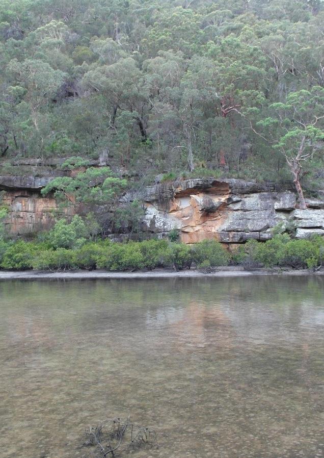
Figure 5. The Cowan Creek shoreline, showing the steep Hawkesbury Sandstone escarpment
Figure 6. The Hawkesbury River, looking south-east from near Wisemans Ferry
Figure 7. An area of alluvial plain, on the south bank of the Hawkesbury River, in the north-west of Hornsby Shire
Source: Hornsby Shire Council nd ‘Hornsby Park’
Initial implications for the survival of Aboriginal archaeological heritage
The nature of the landscape provides some preliminary indications about past Aboriginal occupation of the area, and the archaeological traces that may have survived There is likely to have been a focus on the rich natural resources of the major watercourses, and midden deposits could be expected on higher ground adjacent to the waterfront. Access to fresh water is unlikely to have been a substantial constraint to Aboriginal occupation, given the numerous drainage lines across Hornsby Shire
In the steep topography of the Hawkesbury Sandstone country, sites associated with outcropping sandstone are likely; including grinding grooves, engraved art on sandstone platforms, pigment art within rock shelters, and archaeological deposits within rockshelters. Given the shallow topsoils, it may be that less substantial archaeological deposits are present in open country, that is, outside rockshelters. In contrast, in the southern part of the Shire, in the Ashfield Shale / Mittagong Formation country, sites associated with outcropping bedrock are unlikely to be present. Because of the deeper soils, open sites are likely to be more frequent; comprising assemblages of stone artefacts either on or below the ground surface.

The geological background also provides an indication of stone resources that may have been available to the Aboriginal people of the area. This data also starts to provide an initial picture of important connections tying the Aboriginal people of the Shire into a broader region. Within Hornsby Shire the stone artefacts that have been found in exposed areas and within excavations in rock shelters have largely been made from quartz, silcrete, metamorphic material such as hornfels and volcanic material like tuff and basalt. Aboriginal people may have procured these from locally accessible sources. Many of these stone materials can be found as cobbles along the Hawkesbury River. Quartz can also be found as pebbles in the Hawkesbury sandstone; basalt and tuff can be found at the Hornsby and Thornleigh diatremes and near Maroota Sands; and hornfels and silcrete can also be found at Maroota Sands Ochre was also available in the locality, and was used as pigment for painting; there are two ochre quarries recorded as AHIMS sites in Hornsby Shire.
Stone may also have been acquired by trade or exchange from further afield. Research in Australia
19 Aboriginal Heritage Study
Area
Hornsby Shire Local Government
Figure 8. A section of the Hornsby Diatreme, exposed in a face of the former Hornsby Quarry
and overseas has established that although hunter-gatherer societies may have had access to suitable stone material available nearby, it does not necessarily mean they used it. People would often travel long distances to acquire raw material or procure it by trade or exchange.10 For instance, ongoing research being undertaken by the Australian Museum and the University of New England is providing information on the source of stone used for axes in the Museum collection that originate in the Sydney Basin, including Hornsby Shire. Basalt, which is a common material for axes, is available within the Shire, near the Maroota sands and at the Hornsby and Thornleigh diatremes. However, the results of the research so far indicate that the majority of basalt axes are made from stone that was quarried at Popran Creek / Kulnura on the Central Coast, approximately 20km northeast of the Shire.11
The axe themselves were made and sharpened by grinding or rubbing on exposed sandstone, in particular the Hawkesbury sandstone, which has sand grains that are more uniform in structure than the Narrabeen Group, although the latter is also sometimes suitable.12 During grinding, water is required to wash away the swarf or detritus formed, to reduce friction, and for cooling.13 There are hundreds of grinding grooves scattered throughout Hornsby Shire. They appear as long oblongshaped indentations on exposed sandstone platforms along creek beds close to water, or at higher elevations where spring water and water holes were available
Geology and landform have also strongly influenced how non-Aboriginal people have used the landscape in the post-contact period, and how these activities can have impacted the survival of Aboriginal sites. For example, the rugged topography and infertile soils of the Hawkesbury Sandstone landscape have formed a significant constraint to historical development, meaning that impact on past archaeological remains has been localised. However, historical development, use and occupation has been more widespread across the Ashfield Shale and Mittagong Formation geology in the southern part of the Shire, comprising agriculture, quarrying and residential development This has involved clearing of the native vegetation, meaning that culturally modified trees are unlikely to have survived in these areas. Ground disturbance associated with these historical uses means that few open archaeological sites are likely to have survived completely intact, and many will have been entirely removed. This is discussed further in Section 2.2.3
2.2 Archaeology
The following is an outline of the known archaeology of Hornsby Shire, including the results of a review of reports and publications (Section 2.2.1), and an overview of site data held in the Aboriginal Heritage Information Management System (AHIMS) register (Section 2.2.2).14 The known archaeological sites probably represent only a small part of the archaeology that is present, so an assessment of the archaeological potential of Hornsby Shire is also included (Section 2.2.3). While most of the known Aboriginal archaeology relates to Aboriginal lives in Hornsby Shire prior to the
10 Burton 1985 ; Corkill 2005; Grave et al. 2012; Petrequin et al. 2016; Attenbrow et al. 2017
11 Attenbrow et al. 2017: Attenbrow et al. 2021
12 Attenbrow 2004
13 Dickson 1981
14 Note that the AHIMS site data was not reviewed in detail or checked on the ground as part of the scope of this project. Some corrections and additions were made to the existing site records where possible, but this was not comprehensive.
20 Aboriginal Heritage Study Hornsby
Shire Local Government Area
arrival of Europeans, it also includes sites created or used after this time. These are considered in the discussion of the Aboriginal history of the Shire (Section 2.4 and Appendix 2).
2.2.1 Past archaeological research
Our overview of past archaeological research in Hornsby Shire is divided into four parts: rock art research, archaeological heritage management, archaeological excavations, and museum collections. Most of the research is drawn from the site records and reports held in the AHIMS database, supplemented with published material. The data that we have been able to access does not capture all of the archaeological research that has been undertaken across Hornsby Shire, but it is likely to be a substantial part of it.
Rock art research
The known Aboriginal archaeology of Hornsby Shire and surrounds is characterised by an unusually large number of rock art sites (Figure 11). These have been the subject of non-Indigenous scholarly interest and research since at least the late nineteenth century. Key non-Indigenous scholars involved in the early recording and publication of rock art in the local area included W.D. Campbell, R.H. Mathews (Figure 9), and R.E. Etheridge in the 1880s to early 1900s; and John Tipper, Frederick McCarthy and Ian Sim in the mid-twentieth century.
In the earlier period of recording, the focus was on engraved art, rather than pigment art, and on the religious or ritual meaning of the art, reflecting contemporary non-Indigenous intellectual frameworks and the background of the scholars. The research was generally presented as a salvage exercise, in a constructed context where there were presented to be no remaining local Aboriginal people to understand or care for the art. For instance, in relation to the art itself, Mathews noted ‘these rock pictures are becoming fainter and less numerous every year by reason of the disintegration of the rock surfaces on which they are drawn’.15 In relation to the meaning or significance of the art, Campbell stated ‘The meaning of much of what is thus drawn and cut must inevitable be lost in oblivion with the rapid disappearance of the native races, no effort having been made, in the early days of settlement, to put on record the folk-lore of the blacks’ . 16
However, it is clear that Aboriginal people were still living in the Shire, and even continuing to create rock art (see Section 2.4) Occasional comments included in the publications indicate that these nonIndigenous scholars did draw on information provided by Aboriginal knowledge holders, as recorded in documentary sources and as provided by their contemporaries. For instance, Campbell includes a note on hand stencils: ‘Captain King, an old aboriginal, many years ago informed Mr. Izard, of Brooklyn, Hawkesbury, that the hand marks were made with a mixture of ashes and blood, and squirted from the mouth’.17
In 1899, Campbell published a compilation of recordings of rock engravings from Port Jackson and Broken Bay, based on work that he had done from 1886 to 1893 over the area from Botany Bay to
15 Mathews and Enright 1895:
16 Campbell 1899: 1
17 Campbell 1899: 3
21 Aboriginal Heritage Study Hornsby Shire Local Government Area
Middle Harbour.18 He was then engaged by the Australian Museum to extend the area of the study. His investigation was largely confined to the hill tops, and he noted the scope for further investigation in the valleys and along the creek beds of Narrabeen and Broken Bay.19 Campbell made the following comments on patterning in the location of rock engravings:
The localities selected for these carvings are most varied in character, but they are generally bare of trees. This arises partly on account of the rocky ground where the large smooth surfaces most often occur, and partly perhaps to secure for the most important groups a commanding view of the surrounding country and of sites of other carvings, and the ocean or some sheet of water. The tops of sea cliffs are favourite sites, and also the table-lands which are here about seven hundred feet altitude, and the ridges of the hills along which the natives travelled; sometimes the bald rock prominence formed by the crest of a range is selected, at others the smooth rock that frequently forms the floor of a ‘saddle,’ or a ledge towards the heads of a valley, or in the bed of a stream. They are also generally found near where dry caves and rock-shelters are met with that have been inhabited by the blacks 20
In 1904, Etheridge published a paper on a group of rock engravings at Mount Kuring-Gai, including three human figures, a line of footprints, a boomerang and some fish.21 He interpreted these figures with reference to contemporary anthropologist Alfred Howitt’s explanation of the Kuringal or initiation ceremony of the Murring cultural area, stretching along the coast from Twofold Bay to Port Jackson. He suggested that the three figures were Daramulan and his two wives Ngalalbal.
Recordings from the mid-twentieth century reflect the professionalisation of archaeology, and also the growing interest in conservation of Aboriginal heritage as part of the ‘natural’ heritage of the area. In the mid-1930s, John Tipper published descriptions of Aboriginal rock engravings at the Muogamarra Research Station.22 He noted that there were eight main groups located at the northern end of the Carracyanya ridge, and suggested that one or two of the groups was associated with ceremony. He included an unattributed comment dated to 1856: ‘The natives say that the blackfellows made them a long time ago. They agree in stating that the natives did not reside on these spots, assigning as a reason that these places are frequented by evil spirits. They also state that these places were sacred to the doctors, and were in fact ‘koradgee’ or priest grounds ’23 Tipper said that the purpose of the Muogamarra Research Station was the preservation of the Aboriginal carvings in the area, along with the flora and fauna.24
In the early 1940s, Frederick McCarthy compiled a catalogue of ‘the Aboriginal relics of New South Wales’, drawing on a wide range of documentary sources.25 In the first part of his catalogue, he listed rock engravings, divided between three areas: the Hawkesbury Sandstone area of the Central Coast, the north coast, and the central and northern parts of western NSW. He noted that the known engravings did not appear to occur throughout the distribution of the Hawkesbury Sandstone formation, but also that there were still many unrecorded groups in Kuring-gai Chase, between
18 Campbell 1899
19 Campbell 1899: 2
20 Campbell 1899: 3
21 Etheridge 1904
22 Tipper 1935; ‘Bungaree’ 1935
23 Tipper 1935: 12; ‘Bungaree’ 1935
24 Tipper 1935: 13
25 McCarthy 1942
22 Aboriginal Heritage Study
Area
Hornsby Shire Local Government
Berowra Creek and Wisemans Ferry Road. McCarthy subsequently published a more detailed paper on seven groups of engravings, four within Hornsby Shire and three nearby, which he referred to as ‘important ritual groups’ (Figure 10).26 Among the figures depicted in the engravings, McCarthy identified Daramulan and Baiami and the Rainbow-Serpent, noting that these were among the most important deities in the religious complex of south-eastern Australian tribes.27 From this he inferred the importance of the area from a ritual point of view. Regarding the engravings at Devil’s Rock, Maroota, McCarthy stated that ‘This is undoubtedly one of the finest and most important groups of engravings in the Sydney-Hawkesbury district.’28 He suggested that it was a portion of an initiation ground, and was also the location for historical ceremonies and totemic increase rites.

Source:
Source: McCarthy 1959: fig.4


26 McCarthy 1959
27 McCarthy 1959: 214
28 McCarthy 1959: 211-213
23 Aboriginal Heritage Study
Hornsby Shire Local Government Area
Figure 9. A rock engraving at Kangaroo Point recorded in the late nineteenth century, AHIMS #45-6-0455 (Kangaroo Point), with a recent photo of the same site
Mathews 1895: fig.29
Figure 10. Grinding grooves, near the Old Northern Road at Maroota, recorded in the midtwentieth century
Aboriginal Heritage Study

24
Hornsby Shire Local Government Area
Figure 11. Recorded rock art sites across the LGA
More recent research into the rock art of the region, in particular by Jo McDonald, has taken another approach, and is based on the identification of stylistic patterning in order to shed light on past social interactions. In this research, both engraved and pigment art has been considered. In this more recent framework, the Hornsby assemblage of art sites is placed within the Sydney Hawkesbury rock art region, the largest of four regions identified in NSW (Figure 12) 29 The art of the region has been characterised as follows:
The rock art consists of sheltered (mostly) pigment art sites and engraving sites on open horizontal platforms which represent a contemporaneous art tradition dating mostly to the mid-late Holocene. The shelter assemblages are larger than those on open platforms: very large site assemblages are scattered across the region.
The predominant engraved motif is the human track, but there is an extensive repertoire of life-sized human figures and land and sea animals. There are two main culture heroes: ‘Daramulan’, and ‘Baiame’, mostly distributed through the centre-north of the region. Daramulan is depicted in the rock art of the Calga Women’s Site, and Baiame has been painted on the wall of Baiame Shelter. Stencilling dominates the pigment art in some parts of the region: but dry pigment drawings and paintings are also common and there are a few engravings found in the rock shelters. Animals are simply rendered but naturalistic including details such as a joey in the pouch, or dotted pelts on small marsupials.
McDonald’s study area is the Sydney Basin, defined according to the extent of the Hawkesbury Sandstone formation, roughly from Newcastle in the north to Wollongong in the south.30 On a broader scale, she locates this geological area within a larger culture area, broadly defined by the watersheds of the Hawkesbury Nepean and Georges Rivers.31 She suggests that the art sites that are now present were produced over the last 3,000-5,000 years and into the early colonial period 32
In her analysis, McDonald divides the art of the Sydney Basin into two main components: engravings (petroglyphs) on open sandstone platforms, and pigment art (pictographs) in caves and rock shelters.33 McDonald suggests that the results indicate larger scale group cohesion in the engraving sites, and localised group identifying behaviour in the shelter sites.34 The shelter art tends to be associated with occupation sites, and the data indicates that the creation of the art and domestic activities were broadly contemporary.35 These sites would have been accessible to the broader community, that is not restricted according to categories such as gender or age. McDonald suggests that the stylistic patterning in shelter art reflects social strategies associated with the identification of local territorial groups.
In contrast to shelter art, McDonald found that engraving sites were mostly located on ridgelines and often on access routes, away from economic resource areas and not in the centre of any particular group’s foraging territory.36 She suggested that these sites may have been associated with ceremony and that access may have been restricted to a certain audience (possibly along gender
29 McDonald & Clayton 2016: 6-7
30 McDonald 2008
31 McDonald 1999, using Peterson 1976
32 McDonald 2008: 100
33 McDonald 2008: 100
34 McDonald 2000
35 McDonald 2000; 2008
36 McDonald 1999
25 Aboriginal Heritage Study Hornsby Shire Local Government Area
lines), that the sites were open to inter-group participation, and performed a regional bonding function.
McDonald suggests that the Sydney Region art style emerged during the early Bondaian period, from 8,000 to 4,000 years ago.37 She explains that this was associated with the creation and maintenance of more powerful social networks, in turn required as a result of increased population pressures and social stresses resulting from sea level rise. During the Middle Bondaian period of Art Phase 3 (from 4,000 years ago until the arrival of Europeans), there was a dramatic increase in population density 38 The pigment and engraved art of the region developed and flourished in a context of proliferating symbolic behaviour, especially demonstrating local group social affiliation. This was the main period of art production, and did not involve any appreciable changes in style.
In her earlier analysis, McDonald used Capell’s mapping of language boundaries as an initial basis for identifying social boundaries. However, this non-Indigenous understanding of the relationship between language, Country and people has since been brought into question (see Section 2.5). Two more recent studies have undertaken stylistic analysis of single motifs of the Sydney region rock art These are intended to identify stylistic differences, without the bias introduced by an initial assumption of non-Indigenous language mapping. Analysis of the macropod (kangaroo and wallaby) motif indicated the presence of five subregions within the Sydney region rock art with varied similarities and differences 39 Hornsby Shire extends across two of these subregions, both located to the south of the Hawkesbury, and each having similarities to subregions to the north of the river and across the broader region (Figure 14 and Figure 15) 40 A similar analysis has been undertaken using a single motif in engraved art, the ‘Guringai’ shield 41 Within this assemblage, evidence was found for a stylistic difference between the north of Broken Bay (Brisbane Water and Mooney Mooney drainage basins) and the south (Cowan, Pittwater and Middle Harbour drainage basins). This was interpreted as supporting the theory of a language boundary at Broken Bay (see Section 2.5)
37 McDonald 2008
38 McDonald 2008
39 Tasire & Davidson 2015
40 Tasire & Davidson 2015: 56-58
41 McDonald & Harper 2016
26 Aboriginal Heritage Study Hornsby Shire Local Government Area
Aboriginal Heritage Study Hornsby Shire Local Government Area


27
Figure 12. Australian rock art regions: Hornsby Shire falls within the Sydney-Hawkesbury region (SH on the map)
Source: McDonald & Clayton 2016: fig.5
Figure 13. Stencilled fishtails, from a site near the confluence of Cowan Creek and the Hawkesbury River
Source: McDonald 2008: fig.5.19
Hornsby Shire Local Government Area

Source: Tasire and Davidson 2015: fig.9a
Figure
The
in relation to the distribution of design elements of the macropod motif
Source: Tasire and Davidson 2015: fig.10

28
Aboriginal Heritage Study
Figure 14. The LGA in relation to mapping of five stylistic subgroups of the macropod motif
15.
LGA
Archaeological heritage management
Since the 1970s, a large amount of archaeological research has been undertaken as contract or consulting projects. This work is generally completed on behalf of development proponents who need to address the Aboriginal heritage protection provided by the National Parks and Wildlife Act 1974 and the environmental impact assessment requirements of the Environmental Planning and Assessment Act 1979. In some cases, it is also undertaken to assist with management and conservation of sites.
The Heritage NSW Archaeological Surveys GIS layer includes 102 studies that have been deposited with AHIMS and are within or extend into Hornsby Shire A search of the AHIMS database was also undertaken, using the suburb names within Hornsby Shire, giving another 20 or so results. Overall, about 120 archaeological reports in total, prepared as part of consulting projects across the LGA, have been reviewed for this study (Figure 16, see Section 7.2)
Most of the reports relate to projects in the east and south of Hornsby Shire; in the developed area between Ku-ring-gai Chase National Park to the east, and Muogamarra and Berowra Valley National Parks to the west. One report was completed by John Lough in the late 1960s, relating to a survey of the proposed alignment of the F3 freeway (see below). Aside from this, the earliest reports date from the mid-1980s. About three-fifths have been completed for government projects. In about 40% of the reports, some level of Aboriginal heritage sensitivity was identified, but only seven of the projects have involved archaeological excavation (see below).
A search of the register of Aboriginal Heritage Impact Permits (AHIPs), that have been issued under the National Parks and Wildlife Act 1974 since 2010 (when there were legislative changes), indicates that only two permits have been issued in that time: one allowing salvage excavation prior to Ausgrid works along Berowra Creek, and one allowing community collection of artefacts prior to works at the Laughtondale Gully Road Sandstone Quarry.
1996 Aboriginal heritage study
In the mid 1990s, an Aboriginal heritage study of the Shire was completed on behalf of Council. It was intended to identify and assess the Aboriginal heritage of the Shire, make recommendations for its conservation and management, and promote Aboriginal heritage.42 The study was focussed on pre-colonisation Aboriginal archaeological sites. At the time, a total of 454 sites were recorded in Hornsby Shire, or 215 when duplicates and sites within the NPWS reserves were excluded. Thirteen previously undocumented sites were recorded. The study identified a number of processes that were impacting sites, including siltation, development, graffiti, camping and use of tracks.
In relation to the distribution of un-recorded sites within Hornsby Shire, it was considered that archaeological evidence could be present anywhere in the landscape.43 There was no landform where sites could be said not to be present, although sites were less likely to be present in business, industrial and residential (medium to high density) zones, as a result of previous development.44 On
29 Aboriginal Heritage Study Hornsby Shire Local Government Area
42 Koettig 1996 43 Koettig 1996 v.1: 75 44 Koettig 1996 v.1: 75
the other hand, several landforms were identified as having particularly high archaeological sensitivity:
• estuarine foreshore
• creek or drainage lines with sandstone beds
• ground level sandstone platforms or outcrops larger than 5m²
• sandstone clifflines or isolated boulders that are over 2m high
• creek / river flats on sandstone, alluvium and shale.
The Aboriginal heritage management recommendations in the study were based on four principles:
• No sites are needlessly destroyed
• Sites which are to be destroyed are adequately investigated prior to disturbance or destruction
• Representative samples of sites are preserved
• Further deterioration of sites is prevented where feasible.45
The study recommended that an Aboriginal archaeological assessment should be required by Council:46
• For DA and BAs where a known site is present within or in the vicinity of the subject land
• For subdivision or rezoning applications for land in rural, open space, environmental protection and residential (low density) zones.
For other applications, Council should have discretion to request an assessment if one or more of the following archaeological sensitive features are present:
• Estuarine foreshore
• Creeklines / drainage lines with sandstone bed
• Ground level sandstone platforms or outcrops larger than 5m²
• Sandstone clifflines or isolated boulders which are over 2m high
Many of the recommendations of the study were implemented by Council in its development assessment and approval process, but have since been superseded (see Section 4.2).
Aboriginal community involvement in heritage management
By the mid-1980s, archaeological survey work in the Sydney region had included Aboriginal consultation for some time, to determine the interest and wishes of the local Aboriginal community on site protection and management.47 This had previously involved interviewing people from organisations including the Indigenous Peoples Council at Emerton, the Aboriginal Unity Council of Mt Druitt and residents at La Perouse. In 1984, the Mt Druitt Local Aboriginal Land Council (LALC) was gazetted, then renamed the Dharuk LALC, and was then suggested to be the appropriate body
30
Aboriginal Heritage Study Hornsby Shire Local Government Area
45 Koettig 1996 v.1: 71 46 Koettig 1996 v.1: 77 47 Dallas 1984: 21
to consult on matters relating to Aboriginal sites in the north-west.48 However, in the reports we have reviewed, some of the projects, predominantly from the 1980s, do not appear to have involved any engagement with Aboriginal community members.
The Redfern Land Council was in existence from at least 1983, and in 1985 was superseded by the Metropolitan LALC which was established under the provisions of the Aboriginal Land Rights Act 1983 Hornsby Shire also includes small areas within the administrative boundaries of Deerubbin and Darkinjung LALCs, which were established under the same Act. Since its establishment, engagement with the Metropolitan LALC has been the predominant way in which heritage consultants have involved Aboriginal community in consulting projects. This has involved, variously, discussions about heritage management, involvement of site officers in archaeological fieldwork, provision of reports for review, and independent reporting from the Land Council.
Engagement with the local Aboriginal community during preparation of the 1996 Hornsby Shire Aboriginal heritage study comprised consultation between Council and the Metropolitan LALC, involvement of Metropolitan LALC representatives in the fieldwork; and submission of a draft version of the study to the LALC for review. The LALC provided the following formal response:
The Metropolitan Aboriginal Land Council are the custodians of Aboriginal sites and places in the metropolitan area which includes Hornsby Shire. We envisage our role to protect and preserve Aboriginal heritage. We appreciate the heritage study by Hornsby Council as a critical step in protecting Aboriginal heritage within the Shire.
The protection of Aboriginal heritage is of vital concern to the Land Council. Sites are the symbols of our past. So many sites have been lost that we are particularly concerned about how we manage what is left. The Land Council endorses the approach that all sites are important and that it is essential to incorporate site protection with any kind of development. The Land Council look forward to continuing liaison between ourselves and Hornsby Shire Council in the implementation of that approach 49
In certain periods, Metropolitan LALC has undertaken archaeological assessments independently and directly to Council, rather than through engagement with a heritage consultant. In more recent projects, Guringai Tribal Link Aboriginal Corporation has also been involved in similar ways, preparing independent reports where Aboriginal heritage assessments are required
Recent assessments for larger development projects, assessed as Major or State Significant Projects, have involved consultation with seven or eight Aboriginal stakeholders, referred to as Registered Aboriginal Parties These stakeholders usually include the relevant LALC, Darug Traditional Owner organisations, and Yarrawalk / Tocomwall. However, some of the recent due diligence assessments that were reviewed as part of this study, from the 2010s, did not involve any Aboriginal community consultation at all.
31 Aboriginal Heritage Study
Hornsby Shire Local Government Area
48 Dharuk LALC has since been renamed Deerubbin LALC 49 Koettig 1996 v.1: 4
Aboriginal Heritage Study
Hornsby Shire Local Government Area

32
Figure 16. The location of previous consulting archaeology projects
Archaeological excavation
Very few archaeological excavations have been undertaken within the Shire; only seven excavated sites were identified in the documentation reviewed for this study (Table 1 and Figure 20). Six of the excavations were undertaken prior to impact of the locations by construction of infrastructure, comprising the F3 Freeway, the M2 Motorway, a sewer, and the North West Rail Link. The reason for the seventh is unclear.
Of the seven excavated sites, six were rockshelters. The seventh was initially recorded as an open artefact scatter but was found no longer to be present at the time of the test excavation. Samples from four of the sites have been dated, giving age ranges in the period from about 2,300 to 600 years ago.
AHIMS #45-6-1169 (Crosslands) is a rockshelter located beside Still Creek, about 230m to the west of the junction with Berowra Creek.50 A midden deposit is present within the shelter, and there is pigment art on the rear wall. On the midden surface, the shell was predominantly oyster, and some chert artefacts were also evident. Auger samples of the midden were taken in 1979, and a quartz artefact was recovered. Subsequent investigation of the midden included dating a sample that returned an age of 1,560±120 BP (270-510 AD) (Table 1).
Test and salvage excavation of the site AHIMS #45-6-1649 (CB1; Pyes Creek 1; Cherrybrook) was undertaken in the mid-1980s, prior to construction of a sewer (Figure 17) 51 The site is a rockshelter with archaeological deposit, located adjacent to Pyes Creek, in Cherrybrook. During the test excavation 327 stone artefacts were recovered, and during the salvage excavation 8,238 stone artefacts were found, along with bone, plant and ochre fragments. The artefact density was extremely high, more than 3,000 stone artefacts per square metre. Differences in artefact distribution indicated that different activities were undertaken in the two areas within and in front of the shelter. The predominant raw materials were quartz and silcrete Dating suggested that the intensive use of the shelter began at 2200 +/- 60 B.P (310-190 BC), and it was suggested that the site was probably only used for a relatively short period.
Also in the mid-1980s, several sites were excavated prior to the extension of the F3 Freeway. Test excavation was undertaken at the site AHIMS #45-6-1506 (WB6), and salvage excavation at the sites AHIMS #45-6-1500 (WB1) and AHIMS #45-6-1504 (WB4) (Figure 18).52 All three of the sites were rockshelters containing archaeological deposit; the first was located near the headwaters of a seasonal creek, the second in Yatala Gully about 100m from a major drainage gully, and the third near the headwaters of Apple Tree Creek. The extrapolated artefact densities ranged from 214 to 574 per square metre. Three phases of deposition or occupation were distinguished at AHIMS #45-61500 (WB1), and the characteristics of the artefact assemblage suggested that this was in the
50 AHIMS #45-6-1169, site card.
51 Brayshaw, Helen, and Jo McDonald. 1984. ‘Report on test excavations at Cherrybrook, near Dural, NSW’. Brayshaw and Associates. 1985. ‘An excavation at Cherrybrook, Site 45-6-1649’. AHIMS 1039.
52 Brayshaw and Associates. 1985. ‘Salvage programme: Proposed extension F3 Freeway (Wahroonga - Berowra)’. (Report to Department of Main Roads).
33 Aboriginal Heritage Study Hornsby Shire Local Government Area
Bondaian period (from c.8,000 years ago). The occupation of WB4 was thought to date to the Late Bondaian period (from c.1,000 years ago)
Test excavation of the site PAD1 / DC1 (not registered on AHIMS) was undertaken in the mid-1990s, prior to construction of the M2 motorway.53 The site was a rockshelter with archaeological deposit, located adjacent to Devlins Creek in Beecroft. Excavation of two test pits resulted in the recovery of 602 stone artefacts and some ochre fragments. The majority of the artefacts were quartz and silcrete. Dating of charcoal samples indicated that the site was occupied in 650-865 AD.
Test excavation was undertaken in the location of a previously recorded site AHIMS #45-6-2861 (FR01) 54 This was recorded in 1998 as a surface artefact scatter, but no artefacts were found at the time the site was revisited in 2013. The results of the test excavation showed that the location had previously been disturbed to the depth of the clay subsoil, and that the site was no longer present (Figure 19)
1; Pyes Creek 1;
54 AHIMS #45-6-2861, site card.
55 The table includes data from Attenbrow 2010: 18-20
56 Cal BP is a technical abbreviation meaning Calibrated age Before Present (taken as 1950 for radiometric dating). Calibration refers to corrections that need to be made to the raw ‘Age’ value to work out the age more precisely.
34
Aboriginal Heritage Study
Hornsby Shire Local Government Area
AHIMS No. Site name Age Lab No. Millennium Cal BP56 Site types & features 45-6-1169 Crosslands 1560±120 SUA-1314 2nd Closed 45-6-1500 WB1 [Wahroonga Berowra 1] Closed 45-6-1504 WB4 [Wahroonga Berowra 2] Closed 45-6-1506 WB/6, Ku-ring-gai NP [Wahroonga Berowra 6; Kuring-gai Chase National Park] 580±50 SUA-2612 1st Closed 45-6-1649 CB1; Pyes
[Cherrybrook
Cherrybrook] 2200 +/- 60 BP Closed Artefact, potential archaeological deposit 45-6-2861 FR01 [Franklin Road 01] n/a Open Artefact, potential archaeological deposit (not valid) n/a PAD1 / DC1 [Potential Archaeological Deposit 1 / Devlins Creek 1] 650-865 AD Closed
Table 1. Excavated archaeological sites within the LGA55
Creek 1; Cherrybrook
53 Haglund, Laila. 1995. ‘The Proposed M2 Motorway: Investigation of Aboriginal Heritage Significance - Test excavation of rock Shelter PAD1/C1 on Devlins Creek, Pennant Hills- Beecroft’.
Aboriginal Heritage Study


Hornsby Shire Local Government Area
Source:
1985: Plate 1
Source:
1985:
35
Figure 17. Archaeological excavation in the rockshelter AHIMS #45-6-1649 (CB1; Pyes Creek 1; Cherrybrook)
Brayshaw & Associates
Figure 18. Archaeological excavation at the site AHIMS #45-6-1506 (WB6),
Brayshaw & Associates
Plate 6
Figure 19. One of the test pits excavated at AHIMS #45-6-2861 (FR01)
Source: AHIMS #45-6-2861 (FR 01): Site card
Aboriginal Heritage Study

36
Hornsby Shire Local Government Area
Figure 20. Location of sites where archaeological excavation has been undertaken
Museum collections
A search was undertaken of the Australian Museum collection, for Aboriginal cultural material that may derive from Hornsby Shire. The Museum collection includes assemblages from the archaeological excavations at Cherrybrook, outlined above. It also includes a number of items that have been donated to the Museum by non-Indigenous local collectors, over a period from the late nineteenth to the late twentieth century. Most of these items are listed as edge-ground axes (Figure 21), but there are also other types of items, including flaked stone tools, a hammerstone, and an engraved basalt slab. Ancestral remains, from Cowan Creek, are also held, under a custodial arrangement with NPWS.
The State Library of NSW also holds at least one collection that includes material and records from Hornsby Shire, from the work of John Lough, who is mentioned above 57 This collection includes stone artefacts that were collected by Lough, some probably during his survey of the proposed F3 Freeway, and others labelled as being from Canoelands.

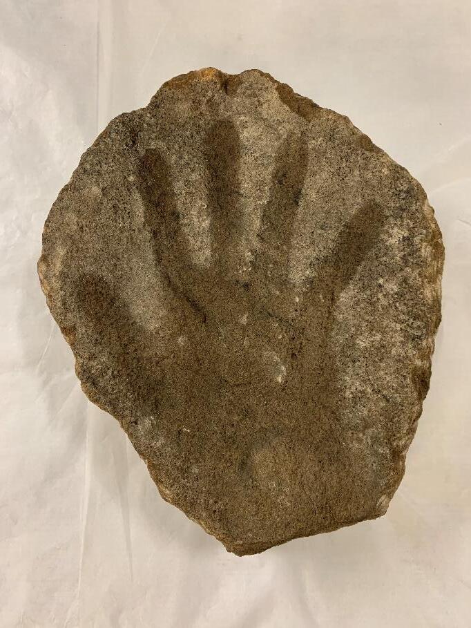
The collections at the Australian Museum and the State Library are likely to represent only a small portion of the Aboriginal material culture that has been taken from Hornsby Shire. Other assemblages may be held in public collections, but their provenance may be obscure, making it difficult to link them to the Shire. During the course of the study, by chance, Dr Irish was told about a hand stencil on a piece of sandstone, that appears to have been removed from a rock shelter on Berowra Creek and is now held at the Scottish National Museum in Edinburgh (Figure 22). The stencil appears to have been cut out of the shelter roof by James C Cox (1834-1912), possibly in the period between 1859 and 1874 The exact location of the shelter is not described. Research on this item is ongoing, as part of a broader research project.58
57 ‘John Lough
Source: Australian Museum, Reg. no. E008313
papers’, State Library of NSW, https://collection.sl.nsw.gov.au/record/1DrLDJy9
58 Details have been provided courtesy of Chantal Knowles, PhD student, Monash University; Dr Alison Clark, National Museums Scotland; and Dr Gaye Sculthorpe, then of the British Museum
37
Aboriginal Heritage Study Hornsby Shire Local Government Area
Figure 21. An edge-ground axe, collected in Beecroft and donated to the Australian Museum
–
Source:
2.2.2 Aboriginal Heritage Information Management System
The Aboriginal Heritage Information Management System (AHIMS) is maintained by Heritage NSW and is the central repository for information on Aboriginal archaeological sites and other places of Aboriginal significance in New South Wales The AHIMS Register initially derived from site records held in the Australian Museum, some of which date back to the first half of the twentieth century. Over the past 40 years additional Aboriginal sites have been registered by professional and amateur archaeologists, as well as Aboriginal community members, employees of organisations such as Councils, and members of the general public.
There are a number of limitations that should be considered when using AHIMS data. The database primarily contains records of archaeological sites created before the arrival of Europeans, rather than places used by Aboriginal people after that time. The data cannot be relied upon for accuracy, without close checking, as errors have accumulated over time. In addition, AHIMS is not a comprehensive register of all Aboriginal sites. The vast majority of land within Sydney has not been subject to detailed inspection, so the absence of registered sites in some areas does not indicate an absence of past Aboriginal use or of surviving physical traces of that use.

A search of the AHIMS database on 12 February 2021 found 923 records within Hornsby Shire
(Figure 23) Of these, 334 are outside the NPWS Reserves, and 61 are within land owned or managed directly by Council.
38
Heritage
Aboriginal
Study
Hornsby Shire Local Government Area
Figure 22. The Berowra Creek hand stencil held at National Museums Scotland
A.1956.1099, courtesy of Dr Alison Clark, National Museums Scotland
Heritage NSW requires that sites recorded on the AHIMS database are listed as either ‘closed’ or ‘open’ A closed site refers to a site within a rockshelter or overhang. All other sites are open. Of the 923 sites within the Shire, 412 (45%) are closed and 511 (55%) are open. Of the 334 sites within nonNPWS land, 136 (41%) are closed and 199 (59%) are open. There is also a set list of 20 site features, used in recording sites on the AHIMS database. Each site can be recorded with one or more of the features. For example, a rockshelter (a closed site) could contain both art and artefacts. The recorded site features within the Shire are listed in Table 2. Instances of 14 of the possible 20 site features are found, but there is a clear predominance of four site features: art, artefact, grinding groove and shell. In terms of site location, the distribution of these most common features strongly aligns with sandstone outcrops and the edges of major waterways.
Art sites, whether pigment or engraved art, are generally associated with outcropping bedrock (sandstone in this locality). In general, pigment art is found within rock shelters or overhangs, while engraved art is found on open sandstone platforms. Of the 598 recorded art sites within the LGA, about half are recorded as closed sites (likely to be pigment art) and half as open sites (likely engraved art). Grinding grooves are also found on outcropping sandstone, generally close to a source of water. Within the LGA, most (91%) are recorded as open sites, which indicates that they are likely to be on sandstone platforms or perhaps on sandstone creek beds.
The site feature ‘shell’ generally refers to a midden One hundred and sixty (62%) of these midden sites are closed, or within a rockshelter. They are all likely to be in close proximity to water where shellfish are (or have been) present, on rocks, mudflats or mangroves In most of the instances of the ‘artefact’ site feature (152 or 75%), it is recorded together with shell, indicating that the artefacts are components of midden sites. Of the remaining ‘artefact’ sites, 32 are enclosed sites, indicating that the artefacts are part of an archaeological deposit deriving from occupation of a rock shelter.
In general then, the known archaeology of Hornsby Shire is associated with outcropping sandstone, and with water. The predominant site types are rock engravings and grinding grooves on open rock platforms; pigment art within rock shelters, which may also contain archaeological deposits including middens; and middens along watercourses. In terms of distribution, the mapping indicates that the known sites are focussed on the major watercourses; the Hawkesbury River, and Cowan, Berowra and Marramarra Creeks; and on the Carracyanya ridgeline that is now followed by the railway line and the Pacific Motorway. Very few sites have been identified across the remnant Ashfield Shale geology in the south-west of the Shire.
However, the identified patterning in the nature and distribution of sites should be viewed with caution. It is likely to be the product, to some extent, of the nature of past archaeological investigations. As noted above, archaeological research in the local area has been focussed on rock art sites, and in particular on engraved art sites (Section 2.2.1). Consulting archaeological projects have addressed a relatively limited portion of the Shire, focussed on the more developed areas along the Pacific Motorway and in the south (Figure 16).
An indication of the effect of consulting archaeological projects on the nature of the known archaeology of Hornsby Shire is provided by a comparison of the AHIMS search results with the
39 Aboriginal Heritage Study Hornsby Shire Local Government Area
Hornsby Shire Local Government Area
results of the 1996 Aboriginal heritage study.59 The search gave a result of 334 sites (excluding NPWS reserves). When compared to the results of the 1996 study, when 215 AHIMS sites were located within the Shire (excluding NPWS reserves), this is only a small increase of 119 over the past 25 years. The proportion of open and closed sites has remained much the same. In 1996, the predominant site features were art (65%), grinding groove (16%), shell (11%) and PAD (6%) Since then, the relative proportion of art and grinding groove site features has decreased, while the proportion of shell and artefact has increased. This does seem to support the interpretation that the early focus on rock art sites, interpreted as ritual and ceremonial, was at the expense of occupation sites such as middens and archaeological deposits.
40
Aboriginal Heritage Study
Site feature LGA LGA excluding NPWS land No. % No. % Aboriginal ceremony and dreaming 4 <1 2 <1 Aboriginal resource and gathering 2 <1 2 <1 Art 598 48 205 45 Artefact 202 16 84 19 Burial 2 <1 0 0 Ceremonial ring 0 0 0 0 Conflict 0 0 0 0 Earth mound 0 0 0 0 Fish trap 0 0 0 0 Grinding groove 125 10 56 12 Habitation structure 5 <1 4 1 Hearth 1 <1 0 0 Modified tree 9 1 7 2 Non human bone and organic material 0 0 0 0 Ochre quarry 2 <1 2 <1 Potential archaeological deposit 23 2 9 2 Shell 259 21 72 16 Stone arrangement 16 1 2 <1 Stone quarry 0 0 0 0 Water hole 9 1 7 2 Total 1257 452
Table 2. Site features recorded for AHIMS sites within the Hornsby Shire60
59 Koettig 1996 60 The percentages have been rounded to the nearest whole number

41
Aboriginal Heritage Study
Hornsby Shire Local Government Area
Figure 23. AHIMS sites in Hornsby Shire, showing the four main site features
2.2.3 Archaeological potential
The known and registered Aboriginal archaeological sites are unlikely to represent all of the sites that are present within Hornsby Shire. Some attempts have already been made to identify the locations where previously unidentified pre-contact Aboriginal archaeological sites are likely to be present. These models consider two main factors:
• Locations where repeated and/or long-term Aboriginal occupation is likely to have occurred. This assessment is usually based on the identification of landforms and natural resources that are thought to have been foci of Aboriginal occupation. Non-tangible reasons for sitepatterning are more difficult for non-Indigenous archaeologists to identify.
• Processes that are likely to have affected the conservation or destruction of Aboriginal archaeological sites. These include natural processes, such as deposition and erosion of sediment, and post-contact development.
The 1996 Aboriginal heritage study concluded that archaeological evidence could be present anywhere in the landscape.61 There was no landform where sites could be said not to be present, but several landforms were identified as having particularly high archaeological sensitivity:
• estuarine foreshore
• creek or drainage lines with sandstone beds
• ground level sandstone platforms or outcrops larger than 5m²
• sandstone clifflines or isolated boulders that are over 2m high
• creek / river flats on sandstone, alluvium and shale.
Sites were less likely to be present in business, industrial and residential (medium to high) zones, as a result of impacts due to previous development.62
Council’s current planning framework refers to the Heritage NSW Due Diligence Code of Practice for the Protection of Aboriginal Objects in New South Wales (see Section 4.2) 63 The Code of Practice identifies five landscape features that indicate the likely existence of Aboriginal objects. This applies only to land that is not disturbed land.64 To provide a preliminary indication of sensitivity, mapping of four of the five landscape features across Hornsby Shire was undertaken using GIS data from NSW Spatial Services:
• Within 200m of water. Modern dams were omitted from the data, so far as they could be identified, then a 200m buffer was created for the remaining watercourses and bodies of water.
61 Koettig 1996 v.1: 75
62 Koettig 1996 v.1: 75
63 DECCW 2010
64 Disturbed land is defined as ‘Land is disturbed if it has been the subject of a human activity that has changed the land’s surface, being changes that remain clear and observable’
42 Aboriginal Heritage Study Hornsby Shire Local Government Area
• Within a sand dune system. Geological mapping indicating the presence of sand was used, and only two possible sand dunes or sand dune systems were identified: the dune behind Bradleys Beach on Dangar Island, and an area of aeolian sand at Maroota. There are at present no known sites within these two areas.
• On a ridge top, ridge line or headland. This was created by running an algorithm that created ridgelines by joining high areas. The ridgelines were then modified by comparison with a Digital Elevation Model.
• Within 200m below or above a cliff face. The 5m contour mapping was used to identify land with a tangent of 57% and above, including the slope classes very steep, precipitous and cliffed. A 200m buffer was then created.
• Within 20m of or in a cave, rock shelter or a cave mouth. Mapping of caves and rock shelters was not possible, as no existing database of these features was found. However, it is likely that these landforms are captured in the mapping of cliff faces
Prior to consideration of disturbance, mapping of the five landscape features indicates that most of Hornsby Shire would be considered to be archaeologically sensitive (Figure 24). This can be refined using the results of the above review of the known archaeology of the Shire:
• Consideration of the type and location of known sites:
o Most (86%) of the known sites are associated with outcropping sandstone, and of the remaining sites, most (64%) are middens.
o Most (74%) of the known sites are within 100m of water.
o Of the 14% of sites that do not appear to be associated with outcropping sandstone, 82% are located within 100m of water (73% within 50m of water).
o Of the 14% of sites that do not appear to be associated with outcropping sandstone, a little more than half (58%) are within land managed by NPWS
The assessment of archaeological potential or sensitivity should also take into account previous impacts from historical development and land use. Heritage NSW provides a very broad definition of ‘disturbed land’, indicating that sites are unlikely to survive in any location where changes due to post-contact land use are visible. However, the extent of the archaeological impact of post-contact land use in a particular area will depend to some degree on the nature of the environment and site types that were present, as well as on the nature and severity of the land use.
Again, this assessment of the impact of disturbance can be refined using data specific to Hornsby Shire. At a broad scale, a visual indication of the archaeological impact of previous land use within Hornsby Shire is provided by the Aboriginal Sites Decision Support Tool (ASDST) (Figure 25). The ASDST is a mapping-based tool developed by Heritage NSW to help in understanding the likely occurrence of particular archaeological site types in the landscape prior to colonisation, the impact of post-contact land use on the survival of archaeological sites, and the likelihood of particular site types being present in the present-day landscape. Mapping of accumulated impacts across Hornsby Shire indicates the most substantial impact within the heavily developed corridor along the Pacific Motorway, and in the south of the Shire. Impact is also shown along the Hawkesbury River, suggesting the effects of flooding and scouring on former archaeological sites.
43 Aboriginal Heritage Study Hornsby Shire Local Government Area
The results of the archaeological review provide the following indications of the impact of postcontact occupation:
• Most of the known sites are within NPWS land and public reserves
• Most scarred trees are within NPWS land and public reserves
• Agricultural land use across the relatively fertile Ashfield Shale means that modified trees are unlikely to survive.
• The site types that are most likely to have survived on developed land are those associated with outcropping bedrock.
• Any sites not associated with outcropping sandstone are most likely to have survived within relatively undeveloped land, in particular NPWS land, reserves, and land zoned for low density development and environmental conservation.
• Land use zoning can provide an indication of the likely impact of past development on the archaeology of particular areas.
This is discussed further in relation to mapping the Aboriginal archaeological sensitivity of Hornsby Shire in Section 3.2.
44 Aboriginal Heritage Study Hornsby
Shire Local Government Area
Aboriginal Heritage Study
Hornsby Shire Local Government Area

45
Figure 24. Indicative mapping of sensitive landscape features, as listed by Heritage NSW Note that the map shows only four of the five sensitive landscape features; rock shelters are not mapped
Aboriginal Heritage Study
Hornsby Shire Local Government Area
Source of data: Heritage NSW, Combined accumulated impacts, Aboriginal sites decision support tool, Version 7.

46
Figure 25. An indication of the extent and severity of the impact of post-contact land use on previous archaeological remains
2.3 Heritage registers
The following heritage registers were searched for items with identified Aboriginal heritage values within the LGA:
• Register of Aboriginal Places. This is available through the State Heritage Inventory, and lists Aboriginal Places gazetted under s.84 of the National Parks and Wildlife Act 1974.
o Two items.
• Australian Heritage Database. This incorporates the World, National and Commonwealth Heritage Lists, which are statutory listings under the Commonwealth Environment Protection and Biodiversity Conservation Act 1999; and the Register of the National Estate, which is a non-statutory archive.
o Nine items.
• State Heritage Register. This includes items that have been listed on the State Heritage Register under s.31 of the Heritage Act 1977.
o One item.
• State Heritage Inventory. This incorporates heritage schedules from Environmental Planning Instruments, completed in accordance with the NSW Environmental Planning and Assessment Act 1979; and from State Government agency Heritage Conservation Registers, completed under s.170 of the Heritage Act 1977
o Eight items.
• Historic Heritage Information Management System. This lists heritage sites and items within the NPWS National Parks system, and is the NPWS 65
o No items.
The registered items are summarised in Table 3 and shown in Figure 26. In some cases, an item is included in more than one register. In summary, 13 items with identified Aboriginal heritage values were found. For items with multiple listings, all listings are included in the table, even where some do not detail Aboriginal heritage values.
For the most part, the identified Aboriginal heritage values associated with these items relate to the presence of Aboriginal archaeological sites; this is the case for all of the listed NPWS reserves. However, there are also several items that are associated with the known Aboriginal history of Hornsby Shire, including Bradleys Beach, Bar Island, Brooklyn Cemetery, the Old Northern Road and Peats Ferry Road. These places are discussed further in Section 2.4 65 At present
47 Aboriginal Heritage Study Hornsby
Local
Area
Shire
Government
the HHIMS is only publicly accessible as a GIS layer containing only item names and locations.
Table 3. Summary of heritage items with identified Aboriginal heritage values that are included in heritage registers
Further details for these places are provided in Appendix 3.
Cemetery, Church Ruins and Memorial Bar Island, Hawkesbury River, Berowra Creek
Berowra Valley Regional Park Berowra Valley Regional Park Berowra Waters Road, Berowra
Hornsby LEP 2013, Schedule 5, A3
Hornsby LEP 2013, Schedule 5, 158 (listing removed)
Dangar Island Bradleys Beach
43X Grantham Crescent, Dangar Island
Lot 78 DP 10902
Hornsby LEP 2013, Schedule 5, A34
Aboriginal Heritage Study
Hornsby Local Government Area
Guragalung Gayanayung Guragalung Gayanayung (Maroota Historic Site)
Lots 1 and 2 DP 1200952, Lots 57 and 108 DP 752029, Maroota
Maroota Historic Site
No Aboriginal heritage details are included in this listing.
The place was formerly occupied by the ‘Benowie Aboriginal tribe’, and contains a number of Aboriginal sites. [The listing for ‘Berowra Valley Regional Park’ has been removed from Hornsby LEP. Item 158 is now ‘Berowra Park’, for which details are not available on the State Heritage Inventory].
The site of the earliest meeting of Aborigines and Europeans on the Hawkesbury, in 1788. The listing includes the remains of a midden.
Aboriginal Place, NPW Act Aboriginal art sites dating from prior to and during early European settlement. The art sites include a rock platform with 85 engravings and 54 grinding grooves, two rockshelters with art and archaeological deposit. The Place also includes part of a bora or initiation ground. The Place was nominated by the Metropolitan Local Aboriginal Land Council.
48
description Register Identified
Place
name Heritage register details National Park Study ID Place name on register Location and property
Aboriginal heritage values
Bar Island Bar Island Cemetery Precinct Berowra Waters Register of the National Estate: Indicative Place 103919
The listing includes a shell midden and the 1880 burial place of Granny Lewis (Sarah Lewis Ferdinand).
- HAHP #04
Berowra Valley Regional Park
HAHP #11
- HAHP #12
Maroota Historic Site
HAHP #01
Ku-ring-gai Chase National Park, Lion, Long and Spectacle Island Nature Reserves
Ku-ring-gai Chase National Park (1980 boundary)
Ku-ring-gai Chase Road, Bobbin Head Register of the National Estate: Registered 2608
Ku-ring-gai Chase National Park, Lion, Long and Spectacle Island Nature Reserves
Ku-ring-gai Chase Road, Bobbin Head National Heritage List: Listed place 105817
Aboriginal Heritage Study
Hornsby Shire Local Government Area
Long Island Nature Reserve Brooklyn Register of the National Estate: Registered 2609
Nature Reserve bushland Hawkesbury River, Long Island, Brooklyn
Hornsby LEP 2013, Schedule 5, 245
Marramarra National Park Indigenous Place Canoelands Register of the National Estate: Registered 15878
Part of Ku-ring-gai Chase National Park is within the LGA. The listing notes the existence of Indigenous values, but states that these have not yet been identified, documented or assessed for National Estate significance.
Long Island Nature Reserve and part of Ku-ringgai Chase National Park are within the LGA. The listing notes that the place includes extensive evidence of Aboriginal use and occupation, including over 800 sites; predominantly shell middens, but also rock engravings and paintings, grinding grooves, stone arrangements, burials and occupation sites. The results of the archaeological excavation of the Great Mackerel rock shelter are noted, and of the Sydney Basin rock art study. No systematic survey had been undertaken at the time of the list, and further sites may be present.
The listing notes the possible existence of Indigenous cultural values, but that these had not been identified, documented or assessed.
No Aboriginal heritage details are included in this listing.
No details provided. Likely to be in Marramarra National Park.
Image keywords associated with the listing are: Indigenous art, Indigenous rock shelters, Indigenous ceremonial sites.
Ku-ring-gai Chase National Park
HAHP #09
Ku-ring-gai Chase National Park, Long Island Nature Reserve
HAHP #09 HAHP #10
Long Island Nature Reserve
Long Island Nature Reserve
HAHP #10
HAHP #10
Marramarra National Park HAHP #05
49
Place name Heritage register details National Park Study ID Place name on register Location and property description Register Identified Aboriginal heritage values
Hornsby Shire Local Government Area
Place name Heritage register details
Muogamarra Nature Reserve Guringai Resting Place – Bujiwa Bay
Restricted location, Cowan Muogamarra Nature Reserve
Aboriginal Place, NPW Act Repatriation site containing the ancestral remains of GuriNgai Aboriginal people taken in the past and held in museums.
Indigenous Place Cowan Register of the National Estate: Registered 15877
Old Man’s Valley Higgins Family Cemetery Quarry Road, Old Man Valley, Hornsby
Old Man’s Valley Cemetery Part Lot D DP 318767
Old Man’s Valley, off Quarry Road, Hornsby
Register of the National Estate: Indicative Place 2614
State Heritage Register, No. 01764
No details provided. Likely to be in Muogamarra Nature Reserve.
Image keywords associated with the listing are: Indigenous art, Indigenous ceremonial sites.
No Aboriginal heritage values are detailed in this listing of the item.
A private cemetery, in use from 1879 to 1931, and associated with the family of Thomas Edward Higgins, an early European settler.
The listing identifies Aboriginal heritage values associated with the locality, rather than with the item specifically. The reference is to information about Old Man’s Valley provided to Peter Read by Dennis Foley. The significance assessment does not include Aboriginal heritage values. Higgins Family Cemetery Quarry Road, Hornsby Hornsby LEP 2013, Schedule 5, A55
Old Northern Road Road, stone wall, bridge, escarpment and drain
Peats Ferry Road Peats Ferry Road
Remains, Hornsby to Peats Ferry
Old Northern Road, Wisemans Ferry Hornsby LEP 2013, Schedule 5, 794 & A69
Cowan Hornsby LEP 2013, Schedule 5, A20 & A29
A private cemetery. No Aboriginal heritage values are detailed in this listing of the item.
The listing comprises a section of the Great North Road, the route of which was said to follow a former Aboriginal track.
No Aboriginal heritage values are detailed in this listing of the item.
50
Aboriginal Heritage Study
on register Location and property
Register Identified Aboriginal heritage values
National Park Study ID Place name
description
Muogamarra Nature Reserve
HAHP #02
Muogamarra Nature Reserve
HAHP #06
- HAHP #03
- HAHP #13
- HAHP #25
Hornsby Shire Local Government Area
Place name Heritage register details National Park Study ID Place name on register Location and property description
Register Identified Aboriginal heritage values
Peats Ferry Road (Former) Peats Ferry Road (former), Brooklyn RMS s170 Register
Unknown Indigenous Place Mount Kuring-gai Register of the National Estate: Registered 13695
The listing notes the observation of Aboriginal engravings by Surveyor Govett in 1829, on the ridge line later followed by the road.
No details provided. Likely to be in Berowra Valley National Park or Ku-ring-gai Chase National Park.
Image keywords associated with the listing are: Indigenous art, Indigenous ceremonial sites.
Unknown HAHP #07
Unknown Indigenous Place Wisemans Ferry Register of the National Estate: Registered 2612
No details provided.
Image keywords associated with the listing are: Indigenous art, Indigenous ceremonial sites.
unknown HAHP #08
51
Aboriginal Heritage Study

52
Aboriginal Heritage Study Hornsby Local Government Area
Figure 26. Heritage items with identified Aboriginal heritage values
Note that this map does not show the four Indigenous Places listed on the Register of the National Estate, or the Guringai Resting Place – Bujiwa Bay Aboriginal Place
2.4 History
Aboriginal people have lived in the Sydney region for tens of thousands of years Traces of most of that period of the Aboriginal past are accessible today only through the material (archaeological) remains of that past (considered in Section 2.2) and through the knowledge of Aboriginal people (considered in Section 2.6 and Appendix 2). The arrival of Europeans was a cataclysmic event for Aboriginal people in Sydney. Violence, dispossession and disease claimed the lives of many and changed the lives of the survivors. Often the stories of these survivors have been ignored by archaeologists and anthropologists looking for an unchanged ‘authentic’ Aboriginal past, or historians focussed on highlighting the decimation of the early colonial years. This has given rise to a popular perception that Aboriginal people ‘disappeared’ from Sydney in the early colonial period and that any survivors were no longer ‘real’ Aboriginal people because of their altered lived experience.
But archaeological and archival records and the words of the survivors themselves tell a very different story. One of the most stark examples of the continuities of Aboriginal life across the faultline of colonial invasion is the ongoing creation of rock art. The review of the pre-colonial Aboriginal archaeology of Hornsby Shire demonstrates the significance of rock art sites in the area (see Section 2.2.1). Within the assemblage of art sites within Hornsby Shire and surrounds, 37 recorded contact motifs have been identified.66 These are found in 20 sites, most of which are located along the Hawkesbury River and where the river discharges into the sea at Broken Bay (Figure 27) 67 Most of the engraved contact motifs are located on ridgelines, either on identified access routes (Peats Ridge, the Old Northern Road) or at aggregation sites, such as Devil’s Rock at Maroota.68 Most of the contact art depicts boats, and these were ships observed from a distance McDonald suggests that this assemblage was produced before there had been much engagement by the Indigenous population with the colonising population and their objects.69 She suggests that the arrival of the outsiders eventually resulted in the termination of the Sydney region’s symbolic and artistic culture, at least as it was expressed in rock art.70
The Aboriginal history of Hornsby Shire can also be traced in other ways. Research and documentation of Aboriginal history has become a focus of non-Indigenous historians over the last few decades. Research undertaken by Dr Paul Irish a decade ago included a detailed review, compilation and mapping of historical references to Aboriginal people in the Sydney region in the century or so after the arrival of Europeans 71 As Irish found, you can often pick up slight traces in the archive of the settlements and travels of Aboriginal people, and even though specific locations can be hard to pinpoint and map, they can starkly illustrate the ongoing presence of Aboriginal people long after Europeans arrived and it has been assumed that they had ‘disappeared’. Some of these places are located in Hornsby Shire and these, and others have been examined in more detail for the current study, in an Aboriginal history of Hornsby researched and written by Dr Michael Bennett,
66 McDonald 2008
67 McDonald 2008: 101
68 McDonald 2008: 110
69 McDonald 2008: 108
70 McDonald 2008: 109
71 Irish 2011, Irish & Goward 2012.
53
including details provided by Darug and GuriNgai descendants. Identified places of significance in the Aboriginal history of the Shire and immediate surrounds are listed in Table 4 and shown in Figure 30

54
Figure 27. Distribution of recorded art sites with contact motifs
Source: McDonald 2008: fig.6.3
Source: McDonald 2008: fig.5.8


Source:
55
Figure 28. An engraving of a macropod, with a sailing ship superimposed, from a site near Maroota on the south side of the Hawkesbury
Figure 29. Tracing of an engraved ship, from a site near the Great North Road
McDonald 2008: fig.6.6

56
Figure 30. Preliminary mapping of known places with historical Aboriginal connections in Hornsby Shire and surrounds
Aboriginal Heritage Study
Hornsby Local Government Area
Table 4. Known places with historical Aboriginal connections in Hornsby Shire and surrounds
Study ID numbers are provided only for places within Hornsby Shire, and for places where a location (even approximate) can be determined. Further details for the places with Study ID numbers are provided in Appendix 3.
Place Note Location
Alexander Berry’s timber lease Broughton worked as a bullock driver
Asquith Public School From c.1948. Attended by
Awabakal and Guringai Native Title Claim
2013 Awabakal and Guringai claim under the Native Title Act
Bar Island
1876 marriage of Sarah Shattles and Albert Rogers. Sarah and Albert lived on the island, where their daughter Elizabeth Jane Rogers was born in 1897
1880 burial of Sarah Lewis
1895 burial of Cyril Joseph Rose
1897 burial of Elizabeth Rose (Moses Shattles acting as sexton)
1897-9 Moses Shattles acted as sexton
1898 birth of Amy Shattles (daughter of Moses Shattles)
Bill Onus’s Residence From at least 1937 to c.1940
Study ID
Hornsby, Normanhurst, Thornleigh, Waitara, Wahroonga n/a
Central Coast, extending from about Newcastle in the north to Mona Vale in the south, and inland to Aberdare and Canoelands
HAHP #59
Berowra Waters HAHP #04
63 Copeland Road, Beecroft HAHP #23
Brooklyn Cemetery Burial place of a child or children of Moses Shattles. Brooklyn Road, Brooklyn HAHP #24
Charles Shattles’s oyster lease
Charles Shattles’s residence
Beecroft
Cheltenham, Normanhurst, Wahroonga
1924 lease on eastern bank of Mooney Mooney Creek, near Murrays’ Gully, renewed in 1929 Mooney Mooney Creek n/a
36 Point Road, Mooney Mooney n/a
Various locations. Aboriginal children placed as apprentices with non-Aboriginal families, in the 1910s, 1920s and 1930s
Exact locations not known HAHP #57
HAHP #41
HAHP #42
HAHP #43
57
Edna Watson (nee Upton)
3 Dudley Street, Asquith HAHP #49
Aboriginal Heritage Study
Hornsby Shire Local Government Area
Place Note Location Study ID
Dangar (Mullet) Island The site of the earliest meeting of Aborigines and Europeans on the Hawkesbury, in 1788. Three huts recorded at this time. The listing includes the remains of a midden. Conflict recorded in 1805 on the island and in the river near the island
Darug Native Title Claim 1998 Darug claim under the Native Title Act 1993
Hawkesbury River, Brooklyn HAHP #12
HAHP #14
Metropolitan LALC land claim Successful land claim by Metropolitan Local Aboriginal Land Council, under the Aboriginal Land Rights Act 1983
NND2001
Guringai Aboriginal Tours Since 2009. Cultural tours run by Laurie Bimson
Hawkesbury River (Dyrubbin)
Continued focus of post-colonisation life, including conflict sites.
Henry Rose’s oyster lease 1887. Henry Rose applied for 600-acre lease
Hornsby (Northern Life) Baptist Church
Hornsby Home Science Secondary School
1954. Soccer team included Herbert Simms
To c.1953. Attended by Edna Watson
Hornsby Hospital c.1955. Residence and possible workplace of Herbert Simms
Hornsby Knitting Company c.1950s. Workplace of Edna Watson (nee Upton)
Hornsby Police Court 1920. Conviction of Darwin Moore for drunk and disorderly behaviour, and use of indecent language
James Bellamy’s property 1816. Daniel Moowattin worked as a labourer on the property
Kent Reach Reserve Dedicated in 1889
Koala Park Sanctuary Late 1930s. Bill Onus worked here, carving wooden artefacts for sale, throwing boomerangs for visitors.
Margaret Tucker’s apprenticeship c1920. Margaret Tucker (nee Clements) worked as apprentice to a non-Aboriginal family from c1920
Matthew Rose’s residence Fisherman at Brooklyn 1932-1980, lived in Brooklyn with family, oyster lease in the mid1950s
Sydney from Lane Cove River and Port Jackson in the north to Botany Bay in the south, and inland to about Mount Victoria
HAHP #60
216 New Line Road, Dural HAHP #58
The Basin Track, Ku-ring-gai Chase National Park HAHP #09
Hawkesbury River HAHP #18
Mooney Mooney Creek n/a
1 Pretoria Parade, Hornsby HAHP #53
205 Peats Ferry Road, Hornsby HAHP #50
38-76 Palmerston Road, Hornsby HAHP #35
Location not known HAHP #52
Peats Ferry Road, Hornsby HAHP #44
House at 99 Castle Hill Road West Pennant Hills n/a
Not within Hornsby Shire LGA n/a
84 Castle Hill Road, West Pennant Hills HAHP #33
Residence on Beecroft Road, Cheltenham, exact location not known
HAHP #40
37 Brooklyn Road, Brooklyn HAHP #38
58
Aboriginal Heritage Study
Hornsby Shire Local Government Area
Place Note Location Study ID
Milson Island Prior to 1865. Possibly owned by Sarah Lewis
1880. Death of Sarah Lewis
Moses Shattles’s selection 40 acres at Peat’s Bight at the mouth of Marra Marra Creek. Home of Moses and Alice Shattles and their four children.
Moses Shattles’s oyster lease
1887. Shattles applied to Dept Fisheries for a 300-acres lease at Porto Bay. No record found of whether it was granted.
Mount Colah camp From c.1950. Residence of Myra and Frederick Upton and family (including Edna Watson), beside the train line.
Mount Wilga Rehabilitation Hospital
1958 admission of Francis Cruse, from the south coast, to recover from illness
Sackville Reach Reserve Dedicated in 1889, revoked in 1943
1937. Burial of William Townsend Onus snr in the Sackville Reach General Cemetery
Sarah Lewis’s property Lived on a property at Marra Marra Creek from the early 1820s, title for three (additional?) acres issued to Lewis (then Wallace) in 1835
St Mary’s Church of England, Brooklyn
Tracker Jack Redtank
Tracker G. McCann
Tracker Peter Wandy
Tracker Joseph Murray
At least five children from local Aboriginal families were baptised at the church between 1902 and 1909
1899 search for armed robber, by tracker Jack Redtank
1902 search for murderer, involving Tracker G. McCann
1911 search for lost boy, involving Tracker Peter Wandy
1921 search for lost person, involving Tracker Joseph Murray
Waitara dry-cleaners Workplace of Edna Watson (nee Upton) from c1953
Waitara Foundling Home 1904 Alice Bolloway and her newborn Alice Mary
1917 at least two Indigenous children
1949 Aboriginal man took his two-year-old child from the home
1970 removal for adoption of Lynda Yarnold’s baby son
Wisemans Ferry 1811 record of spearing of two sows.
Blanket distributions in 1827, 1828, 1830, 1831, (1832, 1833).
1839 baptism of Ballandella, who later lived at or near Wisemans Ferry
1851 marriage of Mary Ann Lewis and James Shattles.
Wisemans Ferry Oval Cricket matches involving residents of Sackville Reach Reserve, including Fred Barber
1905 Boxing Day match included Fred Barber
Milsons Passage, Hawkesbury River HAHP #54
Marra Marra Creek, Fiddletown HAHP #21
Porto Bay HAHP #36
Exact location not known HAHP #37
66 Rosamond Street, Hornsby HAHP #55
Sackville Reach n/a
Marra Marra Creek, Fiddletown HAHP #22
156A Brooklyn Road, Brooklyn HAHP #34
Galston Road HAHP #45
Between Hornsby and Wisemans Ferry HAHP #46
Mount Colah HAHP #47
Marramarra Creek HAHP #48
Location not known HAHP #51
2 McAuley Place, Waitara HAHP #39
Exact locations not known HAHP #62
5575 Old Northern Road, Wisemans Ferry HAHP #56
59
2.5 Intangible heritage
The present study is concerned principally with tangible Aboriginal heritage values, that is, with Aboriginal heritage places and material culture, as protected by current Aboriginal heritage legislation It has not included in depth research into intangible heritage. However, the results of the documentary research and community consultation highlight the importance of this aspect of the heritage of Hornsby Shire, and suggest avenues to follow in further research with Aboriginal community members (see Sections 2.2, 2.4 and 2.6)
Language and place naming
The importance of acknowledging local Aboriginal languages and place names has been raised by both Indigenous and non-Indigenous community members. Research undertaken in the locality to date highlights the care that this type of recognition requires, and the confusion that has been introduced by non-Indigenous theories of language boundaries and social categories. Local nonIndigenous historian Ralph Hawkins has provided an overview of the different interpretations of the languages of Country included in Hornsby Shire that have been made by non-Indigenous scholars.72 He notes several different names that have been used for the languages, and in turn several different interpretations of the Country or people encompassed by each.
Early anthropological work in Australia, from the late nineteenth century until well into the twentieth, tended to group Indigenous people as ‘tribes’, which were understood to approximate the western category of ‘nations’. That is, each tribe had a single boundary that was the same for people, language and Country. In fact, this was not the case. A number of historical interpretations of the languages associated with Country including Hornsby Shire and surrounds are shown in Figure 31 to Figure 35. The different interpretations illustrate the difficulties that non-Indigenous scholars have had with understanding an association of language with Country that is not captured in the western idea of a nation.
Troy’s review of early colonial records indicates that words from one language, which she refers to as the ‘Sydney language’, were recorded over an area that extended from the coast in the east to the Hawkesbury-Nepean in the west, and from the Georges River in the south to the Hawkesbury in the north.73 She notes that there is sufficient data to indicate that the language had at least two dialects, one belonging to the coastal area and the other to the inland area.74
A relatively recent overview of the Aboriginal languages of New South Wales and the Australian Capital Territory includes the languages of the Shire and surrounds in what they call the ‘SydneyHawkesbury languages’.75 This group includes two subdivisions:
• the Sydney language, including Coastal Sydney and Inland Sydney varieties, which was probably associated with Country as far north as the southern shore of the Hawkesbury.
72 Hawkins nd: 25-26
73 Troy 2019: Map 1
74 Troy 2019: 2
75 Wafer & Lissarrague 2008: 140-
60 Aboriginal Heritage Study Hornsby Local Government Area
• the Hawkesbury-MacDonald River language, including Darrkinyung and the Hawkesbury River-Broken Bay varieties, which was associated with Country to the north and north-west of the Hawkesbury.
In each subdivision, one of the two varieties appears to have been associated with the coast and the other with the inland. It is worth noting again that these identified languages and varieties are not necessarily consistent with any social categories or groups, either in the past or the present. While non-Indigenous research can provide valuable data, the determination of present-day group boundaries and names is a matter for Aboriginal people to determine.
The Aboriginal languages of Hornsby Shire are still evident in place names across Country. Some place names are still in use, although the location and pronunciation may have been modified for non-Indigenous use, while others are recorded in documentary and oral sources. Place names found over the course of research for this study are listed in Table 5 and shown in Figure 36 This list is largely based on a compilation made by Hawkins76, which itself was based on earlier research undertaken by Powell.77 There are avenues for further research, involving work with Traditional Custodians and other specialists such as linguists, as well as further documentary historical research Hawkins also notes a number of present-day place names that are based on Aboriginal words from non-local languages. These are also important in the history of Hornsby Shire, raising issues of earlier forms of recognition and also cultural appropriation by non-Indigenous people.
Hawkins suggests that Country associated with particular clans, another social category, follows this division between coastal and inland.78 He applied current theories about language and clan boundaries to his knowledge of the landscape and environment of the Shire. Following Capell’s terms for the languages, he suggested that Hornsby Shire extends across Country associated with the Daruk (to the west) and Kuring-gai (to the east) languages, with the boundary falling along the line of Berowra Creek and the Lane Cove River. Hawkins lists six clans associated with the Country within and around the current Shire:
Daruk language Tuga (thick wood) clan
Wallumede (snapper) clan
Marra Marra (crabs) clan
Kuring-gai language Terramerra (big hill) clan
Cammerai clan
Gari clan
Ceremony and Dreaming
To the south of Thompson’s Corner and along the Darling Mills Creek and Toongabbie Creek catchments down to the Parramatta River
To the south east and east of the Tuga, in the Lane Cove River catchment
To the north of the Tuga
On the eastern side of the Lane Cove River
South-east of Berowra Creek
Centred around Pittwater
Hawkins also refers to a number of locations where creator beings are apparent in the landscape.79 These include Long Island, being the whale or porpoise that carried Baiame up out of the ocean, and
76 Hawkins nd: 57
77 Powell 1994
78 Hawkins 2002
79 Hawkins nd: 23
61 Aboriginal Heritage Study Hornsby Local Government Area
the path of Baiame travelling south from Mount Yengo along the present-day alignment of the Old Northern Road The path of Gurangatty through Country is evident in the Hawkesbury River 80

The spiritual significance of the landscape is also expressed in the rock art, and particularly the engravings, that are such a notable feature of the sandstone country of Hornsby Shire. However, very few sites have been recorded with the ‘Aboriginal Ceremony and Dreaming’ feature that is available when registering sites in AHIMS. Only four were found in the AHIMS records for the Shire:
• AHIMS #45-6-3583 (Ten Bob Ridge - Engraving)
• AHIMS #45-6-3635 (Large water hole and sacred pools)
• AHIMS #45-6-3725 (Govett Ridge – Cole Trig)
• AHIMS #45-6-3726 (Coba Ridge Fire Trail Engraving)
These four sites were all registered by the same individual. They include both archaeological features, being grinding grooves and engravings, and natural features, being waterholes. This apparent lack of recognition of the ceremonial and spiritual significance of sites, in the current data, is at odds with the known significance of the rock art across Hornsby Shire.
Source: Howitt 1904
62 Aboriginal Heritage Study Hornsby Local Government Area
Figure 31. Detail of Howitt’s 1904 map of the tribes of south east Australia
80 GML Heritage 2021: 59; Karskens 2019
Aboriginal Heritage Study

Hornsby Local Government Area
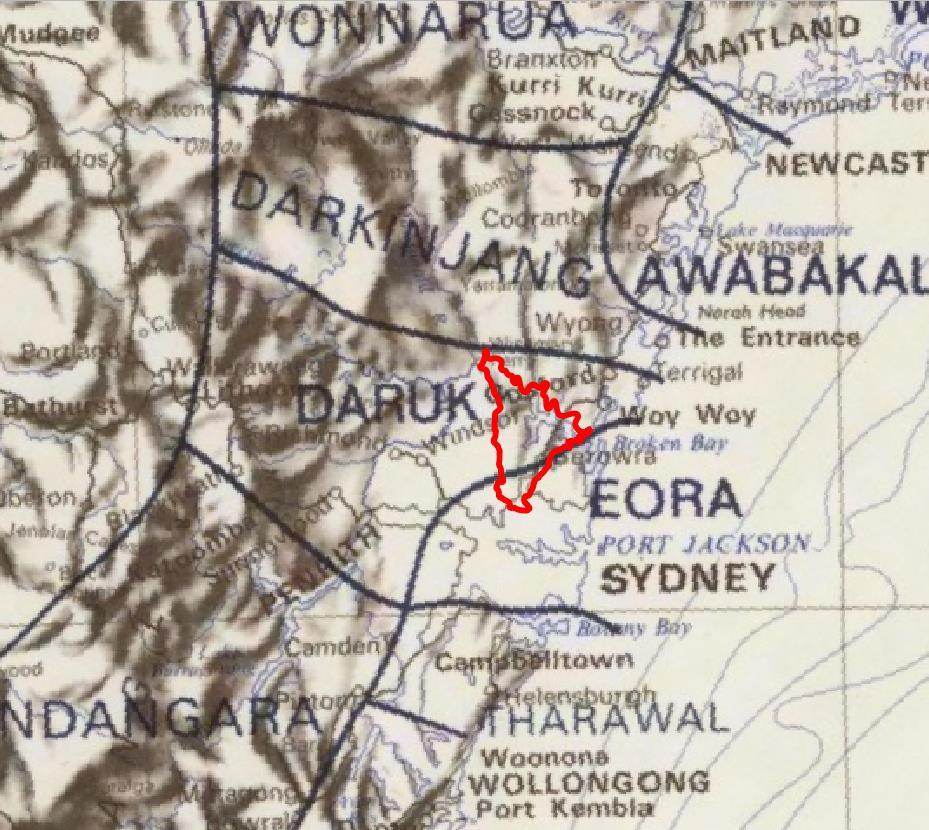
Source: Capell 1970: 22
Source: Tindale 1974
63
Figure 32. Detail of Capell’s 1970 map
Figure 33. Detail of Tindale’s 1974 map
Name Note
Berowra81 Perrara
81 Bennett 2022: 18
82 FBVRP 2001: 6
Aboriginal Heritage Study Hornsby Local Government Area
Source: Horton 1996
Source: First Languages Australia
A Dharuk language word meaning windy place, south-west wind, place of many winds.82 Possible alternate spelling: Perrara (from 1804 reference ‘Perrara on the south branch of the River Hawkesbury’)

Possible meaning: shells.83
64
Figure 34. Detail of the AIATSIS map of Indigenous Australia
Figure 35. Detail of the First Languages Map
Table 5. Aboriginal words used as place names
83 Hawkins nd a: 41
Name Note
Berrilee84
Possible meaning: place of grey kangaroos
Bobbin85 Bobbin trig. Possible meaning: place of smoke
Bujwa86 Bujwa Bay. Possible meaning: night owl or tea tree.
Calabash87 Calabash trig.
Calna88 Calna Creek
Carracyanya89
Gari gunya
Peats Ferry Road / Pacific Highway ridgeline. Possible meaning: home of the Gari people.90
Coba91 Coba trig. Possible meaning: red clay used for body paint
Colah92 Possible meaning: koala
Courangra93 Courangra Point. Possible meaning: grass tree
Cowan94 Cowan, Cowan Creek
Upper part of catchment of Berowra Creek between Thornleigh, Normanhurst, Hornsby Valley.95 Possible meaning: yonder, afar, distant.
Djarra96 Djarra trig.
Dooral97 Dural. Possible meaning: gully98
Dorumbolooa99 Sackville
Dyarubbin100
Dyirabun101 Hawkesbury River
Gibberagong102 Gibberagong Creek, formerly Cockle Creek, renamed by the Trustees of Ku-ring-gai Chase.
Kimerikong / Timberikong Creek. Possible meaning: lots of rocks.
Gundah103 Gundah trig. Possible meaning: going upstream, storm, rain.
Gunderman104 Gunderman trig
Gunanday105 Macdonald River
Gunya106 Gunya Beach. Possible meaning: shelter built of branches and brush.
Karee107 Broken Bay / mouth of Dyarubbin.
Kulkah108 Kulkah Bay.
84 Hawkins nd: 57
85 Hawkins nd: 57
86 Hawkins nd: 57
87 Hawkins nd: 57
88 Hawkins nd: 57
89 Tipper 1935: 12; Hawkins 2002: 22; Bennett 2022: 20
90 Hawkins nd a: 35
91 Hawkins nd: 57
92 Hawkins nd: 57
93 Hawkins nd: 57
94 Bennett 2022: 18
95 Hawkins nd a: 41
96 Hawkins nd: 57
97 Bennett 2022: 19
98 Hawkins nd: 57
99 Bennett 2022: 19
100 Karskens et al. nd
101 Troy 2019: 85
102 Hawkins nd: 57
103 Hawkins nd: 57
104 Hawkins nd: 57
105 Bennett 2022: 19
106 Hawkins nd: 57
107 Tracey Howie pers.comm. 14.10.21
108 Hawkins nd: 57
65 Aboriginal Heritage Study Hornsby Local Government Area
Name Note
Mareela Mareela Reef, Dangar Island. Name chosen in 1985, possible meaning: mullet 109
Maroota
Great North Road
Meroo / Muru110 Maroota [suburb]
‘The name Maroota was in use in the early colonial period. It may mean 'place of the road'[ muru 'road' + -da, place]. The Great North Road ran along the ridge from 1826, but this name suggests there was originally an Aboriginal track there.’111
Marra Marra Possible meaning: lots of crabs.
Muogamarra112 Awabakal word meaning ‘to preserve for the future’
Nyrippin113 Nyrippin Creek
‘Nyrippin is reputed to be a non-local Aboriginal word meaning: to clean or to wash.’
Woolloomoorang / Wulu-marrang114 Wisemans Ferry
‘Likely gloss: mud grass (possibly cumbungi) [wulu 'grass' (H), murrang 'mud' (W), also wulugulin 'cumbungi, bullrushes' (D/S)]. Name for Wisemans Ferry. ‘Wulu’ likely refers to ground cover; 'mud grass' suggests cumbungi or other water plants.’115
Yatala116 Yatala Creek. Possible meaning: flooded.
109 Dangar Island League nd. ‘Mareela Reef’
110 Hawkins 2002: 22; Hawkins nd a: 42
111 Karskens et al. nd
112 Tipper 1935: 13; Hawkins nd a: 44
113 Hornsby Shire Council nd. ‘Self guided bushwalks: Callicoma Walk’
114 Bennett 2022: 19
115 Karskens et al. nd
116 Hawkins nd: 57
66 Aboriginal Heritage Study Hornsby Local Government Area
Hornsby Local Government Area

67
Aboriginal Heritage Study
Figure 36. Some of the documented Aboriginal placenames (local and non-local) in and around Hornsby Shire
2.6 Community knowledge
The project has included consultation with members of the Aboriginal and non-Indigenous community. The results of these components are summarised below.
2.6.1 Aboriginal community consultation
An Aboriginal community engagement strategy for the project was prepared in consultation with Council project managers and the Hornsby Aboriginal and Torres Strait Consultative Committee (HATSICC). The strategy recognised the following key Aboriginal community groups:
• HATSICC
• Darug and GuriNgai Traditional Custodians
• Aboriginal people with historical connections to Hornsby Shire
• Metropolitan, Darkinjung and Deerubbin Local Aboriginal Land Councils.
The strategy has included the following components:
• Submission of project documentation for review to HATSICC. This documentation to date has included the proposed engagement strategy, progress reports, two drafts of the history, and a preliminary draft of the overall report. The Aboriginal Heritage Information Licence Agreement application to access the AHIMS data was reviewed by HATSICC, and approved for submission by Darug and GuriNgai members of the committee. Project team members attended two meetings of HATSICC to provide an introduction to the project and a later progress update.
• An initial project workshop was held with GuriNgai descendants, to discuss the methodology and objectives of the project. The field inspection program was developed and undertaken with representatives of the Darug and GuriNgai descendants (Section 2.7). Project documentation has also been provided for review by the Darug and GuriNgai representatives. To date, this has included the proposed engagement strategy, progress reports, two drafts of the history, and a preliminary draft of the overall study.
• Informal interviews with Darug and GuriNgai knowledge holders were undertaken as part of the research for the history (Appendix 2). Where the results of the documentary research suggested individuals and families with historical connections to Hornsby Shire, attempts were made to contact these individuals.
• Council held a general community consultation period in June 2021, providing project information and inviting input. As part of this process, notifications were sent to the Metropolitan, Darkinjung and Deerubbin Local Aboriginal Land Councils; to Darug Custodian Aboriginal Corporation; and to Guringai Tribal Link Aboriginal Corporation.
In addition, some input from local Aboriginal community members and from Darkinjung LALC was also provided over the course of the preparation of other components of the Hornsby Heritage Study. Where appropriate, details were forwarded for inclusion in this report.
In summary, comments, recommendations and suggestions that have been made over the course of the project to date have included:
68 Aboriginal Heritage Study Hornsby Local Government Area
• Substantial complexities and sensitivities involved in the identification of Traditional Custodians, and difficulties that can be caused to the community by inaccurate or inappropriate acknowledgement of Country, on signage and in documentation, and in particular by changes made without adequate consultation.
• The importance for Darug and GuriNgai descendants of tracing their connection to Country through their family histories, and the way in which these histories have shaped their responsibilities.
• The importance noted by Darkinjung LALC of acknowledging the role of LALCs as cultural authorities, under the Aboriginal Land Rights Act 1983, in instances where Traditional Custodianship has not been determined through the Native Title or other formal legal processes.
• The importance of ensuring control of Aboriginal knowledge, and information about Aboriginal heritage, by appropriate Traditional Custodians. Caution with the distribution of knowledge, both within the Aboriginal community and more broadly among the nonIndigenous public.
• An appreciation of the knowledge of and respect for Aboriginal heritage among some nonIndigenous individuals, including Council and NPWS staff, local historians and local residents. Noting that this should always be cross-checked against Aboriginal knowledge.
• An acknowledgement of the possible role of non-Indigenous residents and Council staff in the management and conservation of Aboriginal heritage, including site monitoring Noting that any conservation and management works should be developed in consultation with Traditional Custodians.
• The importance of understanding the limitations of the available data regarding the known archaeology of Hornsby Shire, and in particular the AHIMS data. The data is important, but should be understood within a broader framework of cultural knowledge of Country. To assist with this, cultural awareness and site identification training may be valuable for Council staff involved in Aboriginal heritage management
• Concerns with previous actions taken to manage impact to Aboriginal heritage in a development context, which are now seen as inappropriate. For instance, during construction of the F3 Freeway, the removal of rock engravings from a site, probably to the north of the Hawkesbury, to the Ku-ring-gai Wildflower Garden at St Ives. Construction of the Freeway through a sacred area is thought to be related to ongoing safety issues along a particular stretch of the road.
• Lack of access for Traditional Custodians to sites on private property and on Council land, in contrast to sites on NPWS reserves.
2.6.2 Non-Indigenous community consultation
Council also invited the general community to comment on the Aboriginal study, during the research phase, in June 2021. A project page was created on the Council website and promoted with social media posts on Facebook, and in an advertisement in the local newspapers. Emails were sent to local community groups and the project was included in Council’s E News. The notices provided project information and invited input.
69 Aboriginal Heritage Study Hornsby Local Government Area
In response, comments were received from 10 individuals, and one organisation (the Dangar Island Historical Society). In addition, Council forwarded relevant correspondence that was received from the general community over the course of the study, and the Extent Heritage consultancy teams forwarded relevant information from the community consultation undertaken during the preparation of the Landscape Heritage and Historical Archaeology studies.
Information and suggestions were also provided by the Hornsby Heritage Advisory Committee, the Hornsby Aboriginal and Torres Strait Islander Consultative Committee, and by Council staff.
To date, the following places have been identified by non-Indigenous community members as having or potentially having Aboriginal heritage values:
• Bradleys Beach and Kiparra Park, Dangar Island
• Canoelands Cave, Muogamarra Nature Reserve.
• Flat Rock Point, McKell Park, Parsley Bay, Brooklyn.
• Forty Foot Rock, Parsley Bay, Brooklyn.
• Hawkesbury River
• Kangaroo Point, Brooklyn
In addition, the importance of Aboriginal archaeological sites (and particularly rock art sites) has been emphasised. Particular sites that have been mentioned include middens on Dangar Island, and engravings in Old Mans Valley (possibly non-Indigenous in origin)
Comments, recommendations and suggestions have included:
• A high level of interest among the non-Indigenous community of Hornsby Shire in the conservation of Aboriginal archaeological sites. Recommendations include monitoring programs and site audits.
• The importance for the local non-Indigenous community of knowing about the Aboriginal history, heritage and contemporary community of the Country that is now included within the Shire. Noting that at present, this aspect of the heritage of the Shire can be obscure to non-Indigenous people. Also noting the importance of recognising Aboriginal peoples and places specific to the Shire (rather than a generic Aboriginal history). Recommendations include use of Aboriginal places names, signage, public interpretation, walking tours.
• The importance of prioritising conservation and protection of Aboriginal heritage places, while recognising the public interest in Aboriginal heritage and the importance of recognising Hornsby Shire as Aboriginal Country.
• The importance of respecting Indigenous Cultural and Intellectual Property (ICIP). Recommendation that Council have a contact person to assist with ICIP enquiries.
• The importance of understanding sites in the context of stories which may connect places, communities and the natural environment. Recommendations include incorporation of First Nations pedagogies, knowledge systems and research methodologies in the project and ongoing.
70 Aboriginal Heritage Study Hornsby Local Government Area
• A heightened interest in the cultural and natural heritage of Hornsby Shire among local residents during the pandemic.
• The difficulty in some cases of determining whether particular sites are Aboriginal heritage places, instances of engraving sites were mentioned.
Comments in relation to Council management of Aboriginal heritage more specifically have included:
• Importance of consistent and clear processes of Aboriginal community consultation.
• Importance of ongoing Aboriginal cultural heritage and site identification training for key staff involved in the planning, assessment and completion of works that may affect Aboriginal heritage.
• Requirement for a procedure to be followed in the event that Council staff or members of the public identify sites.
• Requirement for heritage management procedures for Council’s day-to-day work and developments.
• The importance of access to data about the known Aboriginal heritage of Hornsby Shire, in particular AHIMS data, and to relevant expertise including Traditional Custodians.
2.6.3 Public heritage interpretation
Instances of Council’s existing public Aboriginal heritage interpretation were noted over the course of the project are listed in Table 6. This is not a comprehensive list, but does indicate the range of media, programs and information that Council has made available to the public. Although there are many significant Aboriginal archaeological sites within the NPWS reserves, only a small number of these are promoted for public viewing and understanding (Table 7)
Interpretation on site Bar Island
Pioneers Heritage Trail
Kiparra Park, Dangar Island
Brooklyn mangrove boardwalk
Fagan Park
Larool Creek Trail
Blackfellow’s Head, Westleigh
Community organisations
Convict Trail Project – community-based organisation promoting the Great North Road – supported by Council
Public programs and education Natural Resources Branch runs a guided walks program, which includes visits to Aboriginal sites, but only where these are already on the public record, for instance with NPWS signage
Hornsby Shire Council Community Nursery, managed by the Natural Resources Branch. Promotion of known Aboriginal bush foods, to local schools and residents at plant giveaway events. Staff maintain a list of bushfood plants available at the nursery, and information is available on plant information posters and in a brochure on ‘Aboriginal uses of plants’ (produced by the North Head Sanctuary Foundation).
In partnership with Pittwater Council (now part of Northern Beaches Council), Council developed an Aboriginal seasons biodiversity calendar. The Natural
71
Heritage Study
Area
Aboriginal
Hornsby Local Government
Table 6. Instances of public Aboriginal heritage interpretation supported by Council Type Details
Type Details
Resources Branch hosted a series of guided bushtucker walks, led by a NPWS Aboriginal Ranger.
Self-guided bushwalks
Several of Council’s series of self-guided bushwalks include references to the evidence of past Aboriginal occupation that may be present in the area, and a caution to respect any sites or objects. The following walks include more specific references as well:
Bar Island Heritage Trail. The identified points of interest include a midden, and the information sheet includes guidance on the statutory protection afforded to the site, and a request to respect and avoid disturbing the site.
Callicoma Walk The name of Nyrippin Creek is noted as a possible non-local Aboriginal walk, and the Jungo (junction of Berowra and Zig Zag Creeks) is highlighted as a possible Aboriginal campsite.
Dangar Island Walk. Bradleys Beach is one of the identified points of interest, but the Aboriginal heritage significance of the place is not noted.
Council website
1996 Aboriginal heritage study
Reference list for further reading and research
Four information brochures:
• NSW National Parks and Wildlife Service. Information about the role of the NPWS, and the National and Regional Parks within the Hornsby LGA.
• Metropolitan Local Aboriginal Land Council and Aboriginal people. Information about the role of the LALC, and the past, present and future of the Aboriginal community.
• Walking into History: Aboriginal Sites. Two brochures outlining five sites where rock engravings and pigment art can be seen by the public: Washtub Gully, Berowra Waters; Berowra Waters; Mount Kuring-gai Footprints; Quarter Sessions Road, Westleigh; and Currawong Road, Berowra Heights. The brochures include guidelines to avoid impact to the sites, and advice on who to contact if an unrecorded site or damage is identified.
Two short films:
• Rainbow Serpent’s Cave. Aboriginal story teller Uncle Wes Marne talks about how Aboriginal families used caves and the land as they moved through.
• Devil’s Rock. Darug Elder Aunty Edna Watson’s connection to this area is carried on through her love of the Darug language, the land and her family. Gathering at the cleverly named Devil’s Rock Aunty Edna’s granddaughter Krystal speaks their language and welcomes everyone.
Hornsby Shire Recollects The website is open to public contributions, following registration. It includes a substantial amount of material on the pre-colonisation Aboriginal heritage of the Shire, and a smaller amount of material on post-colonisation history and heritage. Much of the material has been contributed by local historian Ralph Hawkins, including his paper ‘Aboriginal life in the bushland shire’/
NPWS Reserve
Berowra Valley National Park Lyrebird Caves guided walk: Midden adjacent to Berowra Creek Place of Winds interpretive trail: Evidence of Aboriginal occupation
Berowra Valley Regional Park No details available
Dural Nature Reserve No details available
Ku-ring-gai Chase National Park Within Hornsby LGA:
72 Aboriginal Heritage Study Hornsby Local Government Area
Table 7. Publicly promoted Aboriginal heritage sites within the NPWS Reserves
NPWS Reserve
Bobbin Head Information Centre: Aboriginal culture of the Park
Kalkari Discovery Centre: Aboriginal history of the Park
Mount Ku-ring-gai track to Berowra Station: Midden
Outside Hornsby LGA:
Aboriginal cultural tours at The Basin: Rock art (Basin Aboriginal art site, & Red Hands Cave) and Aboriginal culture, history and heritage. Run by Guringai Tours
Aboriginal heritage walk (Resolute loop trail): Pigment rock art (Red Hands Cave), rock engravings and a rock shelter at West Head
America Bay walking track: Rock engravings
Basin Aboriginal art site: Rock engravings
Basin track and Mackerel track: Rock engravings (Basin Aboriginal art site)
Centre Trail: Rock engravings
Mount Murray Anderson guided walk: Rock engravings
Red Hands Cave walking track: Rock art (Red Hands Cave)
Resolute Beach guided walk: Rock art (Red Hands Cave) and rock shelter (possible 1788 encounter between Aboriginal people and Arthur Phillip)
Resolute picnic area: Rock art (on the Aboriginal heritage walk)
Sphinx Memorial to Bobbin Head loop track: Middens
2.7 Site visits
The project included a small fieldwork component; this was not a comprehensive or sample survey of the LGA, but targeted places of known significance, and some unrecorded sites, in order to discuss Aboriginal heritage values and management. The following places were visited as part of the study:
• Bar Island
The island is also the location of two archaeological sites, registered on AHIMS; one is a midden (#45-6-0349) and the other includes rock engravings and grinding grooves (#45-6-3200). Both sites were inspected during the site visit. The midden is evident as a sub-surface deposit containing a large amount of shell, some of which is eroding onto the beach (Figure 37). The engravings and grinding grooves are located on the rock platform below the high water mark, and were concealed by flotsam. An additional possible motif was recorded.
The island is also of particular significance in the Aboriginal history of Hornsby Shire. Interpretive signs on the island refer to the midden; the involvement of local Aboriginal community members in managing the place; Sarah Lewis and her burial place on the island (the location is not identified); and the Rogers, Rose and Shattles families (see Figure 38).
73 Aboriginal Heritage Study Hornsby Local Government Area
Lane Cove National Park No details available Long Island Nature Reserve No details available Maroota Historic Site No details available Marramarra National Park No details available Mount Kuring-gai Aboriginal Area No details available Muogamarra Nature Reserve No details available
• Canoelands Aboriginal Site, Muogamarra Nature Reserve
This is a particularly significant rock art site. It is on land that was previously managed by Cumberland County Council, and is now managed by NPWS as part of the Muogamarra Nature Reserve The site is signposted, and part is fenced, but NPWS asks that members of the public, with the exception of Traditional Custodians, request permission to visit.
• Dangar Island
The Dangar Island Historical Society (DIHS) invited the project team to visit, and gave a tour of Aboriginal heritage places on the island. One of the first DIHS projects, in the early 1980s, was to work with NPWS to register six sites on the island, and place NPWS plaques (now illegible) to mark one group of engravings. The current DIHS priorities include seeking advice on protection and conservation of the sites, and on whether it is appropriate to identify the sites to the public by signage, maps and listings; and undertaking further research into the Aboriginal history and heritage of the island with specialists including Traditional Custodians
• Guragalung Gayanayung (Maroota Historic Site) Aboriginal Place
This is one of two gazetted Aboriginal Places in the LGA, the other being a repatriation place; Guringai Resting Place – Bujiwa Bay (see Section 2.3). The listing notes that the gazettal as an Aboriginal Place resulted from a nomination that was made by the Metropolitan Local Aboriginal Land Council. The listing covers the whole of the reserve managed by NPWS as Maroota Historic Site. The reserve is not open to the public. Components of the Place include rock engravings, grinding grooves, rock shelters with art and archaeological deposits, and part of an initiation ground.
• Unrecorded sites
Stephen Pym, from Council’s Natural Resources team, had recorded a number of unregistered sites, from his own research and observations. Mr Pym provided information about these sites and took the project team to visit several of them:
• Blackfellow’s Head, Westleigh. Described below.
• Devlins Creek rockshelter (PAD1/DC1). This site is one of the seven within the LGA where archaeological excavation has been undertaken (see Section 2.2.1). It is now located under the M2 Motorway, as the design was modified to avoid removal of the site.
• Larool Creek trail. Pym has noted a possible Aboriginal camp site, due to the presence of Scrub Turpentine (Rhodamnia rubescens), which is uncommon in the local area.
• Pyes Creek engraving Rock engravings on sandstone pieces that have been moved. The origin of the engravings is not clear, but they may be Aboriginal.
• Zig Zag Creek A site interpreted as a tool manufacturing site has been noted by Hawkins alongside the creek, and Pym has identified a rock shelter in the escarpment above the creek.
74 Aboriginal Heritage Study Hornsby Local Government Area
During preparation of the study, opportunities arose for three additional site visits:
• Cheltenham
During planning for construction of a shared pathway, along The Crescent at Cheltenham, the Council project manager identified the site AHIMS # 45-6-3083 (Crescent 3) within the footprint of the proposed works, and requested advice from Laurie Bimson (GuriNgai descendant). As a result, it was possible to address the potential for impact to the site. However, management of the site was difficult because it was not evident in the landscape at the time of the site visit, the AHIMS site card did not include the details from the original recording of the site, and the associated report was not in the AHIMS database. There was also some uncertainty regarding the objectives of Traditional Custodian consultation, and whether this was sufficient to address Council’s responsibilities under the NPW Act.
• Fiddletown
Local residents invited Laurie Bimson (GuriNgai descendant), and Tegan Burton (NPWS) to visit previously unrecorded rock art sites that they had found (Figure 43 and Figure 44) The sites are in a sandstone escarpment running roughly parallel to a watercourse, at a distance of about 100-200m, in undeveloped land (zoned for Environmental Management).
• Westleigh
During planning for design of a short walking track and lookout at Quarter Sessions Road in Westleigh, the Council project manager requested advice from Laurie Bimson (GuriNgai descendant). A group of rock engravings and other sites have been recorded at Westleigh, represented in seven AHIMS sites, referred to collectively as Blackfellow’s Head. The sites were known to Council staff, and it was clear that the locations recorded in AHIMS are incorrect.
The recorded sites include engravings, including motifs interpreted as fish, macropods, and a koala; possible remnant stone arrangements; an assemblage of artefacts; grinding grooves; and an engraving of a person that is likely to be non-Aboriginal in origin Several recordings of one or more of the sites have been made since at least the 1930s. In McCarthy’s recording, the group of sites was recorded as a single complex. The complex was given new AHIMS numbers in the late 1970s, and again in the 1980s
A review of historical aerial photographs indicates that the general area had been quarried from at least the 1940s, and was subdivided for residential development in the late 1970s. At this time, a large block of sandstone supporting one of the engravings was cut out, probably from the current location of a dead-end off Quarter Sessions Road, and moved to an undeveloped block about 180m to the west. This re-located engraving is signposted and publicly accessible (Figure 45 and Figure 46) A second engraving is likely to be located within a residential property, and the exact location and current status of this site is unknown. Others of the group of sites are within Berowra Valley National Park, immediately adjacent to the residential subdivision
75 Aboriginal Heritage Study Hornsby Local Government Area
Aboriginal Heritage Study Hornsby Local Government Area
During our site visit, the resident of two of the properties adjacent to elements of the sites came out to talk to us and to check on the sites. They noted that there had been increased public use of the area and the local bushwalks during the pandemic.


76
Figure 37. Midden on Bar Island
Figure 38. One of the interpretive signs on Bar Island
Aboriginal Heritage Study Hornsby Local Government Area


77
Figure 39. Bradleys Beach, Dangar Island
Figure 40. NPWS sign at Dangar Island advising of the statutory protection of Aboriginal heritage
Figure 41. The Devlins Creek rock shelter PAD1/DC1, with past Aboriginal occupation dated to 650-865 AD
Aboriginal Heritage Study Hornsby Local Government Area


78
Figure 42. Pyes Creek engraving
Figure 43. A previously unregistered site at Fiddletown
Figure 44. A previously unregistered site at Fiddletown
Aboriginal Heritage Study Hornsby Local Government Area


Source:
79
Figure 45. View towards the re-located rock engraving AHIMS #45-6-0228 (Blackfellows Head Spur 1) at Westleigh
Figure 46. NPWS sign at the re-located rock engraving AHIMS #45-6-0228 (Blackfellows Head Spur 1)
Figure 47. The re-located rock engraving AHIMS #456-0228 (Blackfellows Head Spur 1)
AHIMS #45-6-0228: Site card
3 Aboriginal cultural heritage in Hornsby Shire
In this section we look at what may remain in Hornsby Shire as the physical traces of the long history of Aboriginal connections to the area. Compared to the results of the research outlined above, this is a relatively narrow view of the Aboriginal heritage of the Shire, because it is intended to form the basis for the management strategy that we present in the next section and complement the other elements of the overall Hornsby Heritage Study. Although we are limited in what type of heritage we can address in the study (see Section 1.3), the wholistic view informs our understanding of its significance and its management
3.1 Historical places
The Aboriginal history of Hornsby Shire presented in Appendix 2 and referred to in Section 2.4 has identified a large number of places associated with the Aboriginal history of the Shire. Listing these places as heritage items may assist in the recognition and conservation of their Aboriginal heritage values. Recommendations for listings are outlined in Table 8 and Table 9 and shown in Figure 48, and details are provided in Appendix 3 In most cases, these places are already listed as heritage in Schedule 5 (Environmental Heritage) of the Hornsby Local Environmental Plan 2013, with nonIndigenous heritage values. However, the Aboriginal history and heritage values of these items are not recognised in the listing details. Two additional listings are also recommended; for parts of Moses Shattles’s property and for the Waitara Foundling Home (Table 9).
For the places that are already listed, inclusion of the Aboriginal history and heritage values would not require any amendment to the HLEP schedule. It would involve amendment of the statement of significance, assessment of significance, description, history and historic themes on the supporting heritage inventory sheet within the State Heritage Inventory and Hornsby Council’s Heritage Register. These amendments can be undertaken by Council staff following consultation with community and government agency stakeholders which will take place during public exhibition of the report with its findings. The management and development assessment implications of the Aboriginal values being added to the heritage significance of the places are provided in Section 5
The two additional listings will require an amendment to the HLEP schedule to include the proposed places as new Archaeological Sites. A heritage assessment against the Heritage Council of NSW heritage assessment criteria has been included within Appendix 3 for each proposed place to assist preparation of the supporting inventory sheets.
Listing has not been recommended for Aboriginal heritage places where the exact location is not known, where the place is within an NPWS reserve, or where there is low potential that any significant material evidence survives. In some cases, additional research may provide enough detail to allow the place to be listed, or for Aboriginal heritage values to be added to existing listings. This is the case for known events at Wisemans Ferry, including blanket distribution, and baptism and marriage of Aboriginal people, some of which events may have occurred within Hornsby Shire.
Listing has not been recommended for the Hawkesbury River or its main tributaries Berowra and Cowan Creeks. These are places with significant and diverse Aboriginal heritage values, including creation sites in the landscape, places of colonial conflict, enduring archaeological sites, and ongoing
80 Aboriginal Heritage Study Hornsby Local Government Area
occupation into the present day. Depending on the results of the ongoing Hornsby Landscape Heritage Study, it may be appropriate to manage these Aboriginal heritage values through listing the waterways as associative landscapes, while specific places are managed as listed items or archaeological sites.
81
Aboriginal Heritage Study
Hornsby Local Government Area
Table 8. Aboriginal heritage places recommended for inclusion of Aboriginal heritage values in current listings
Further details for these places and their Aboriginal heritage values are provided in Appendix 3.
Aboriginal Heritage Place Current heritage listings
Bar Island Bar Island Cemetery Precinct Cemetery, Church Ruins and Memorial
Brooklyn Cemetery Brooklyn Cemetery
HLEP A3
Aboriginal Heritage Study
Hornsby Local Government Area
Dangar Island Bradleys Beach
Kiparra Park bushland
Hornsby Hospital Hornsby Hospital
HLEP 204 & A13
Recommendation
Update inventory sheet with Aboriginal heritage values as per Appendix 3
Update inventory sheet with Aboriginal heritage values as per Appendix 3
HAHP #04
HLEP A34
HLEP 334
Update inventory sheet with Aboriginal heritage values as per Appendix 3
HAHP #24
HLEP 529
Update inventory sheet with Aboriginal heritage values as per Appendix 3
HAHP #12
HAHP #14
HAHP #27
HAHP #32
HAHP #35
Hornsby Police Court (former Drill Hall) Hornsby Shire Council Chambers
Kenley Park and Hornsby Shire Historical Society Drill Hall
Kangaroo Point Kangaroo Point
HLEP 520 (original location)
HLEP 608 (present location)
HLEP A21 & 99
Update inventory sheet with Aboriginal heritage values as per Appendix 3
Update inventory sheet with Aboriginal heritage values as per Appendix 3
HAHP #44
HAHP #31
Koala Park Sanctuary Koala Park Wildlife Sanctuary Grounds
HLEP 786
Update inventory sheet with Aboriginal heritage values as per Appendix 3
HAHP #33
McKell Park McKell Park – lower, upper, cabbage palms and WWII gun and emplacements
Milson Island Prison building
HLEP A14 & 225
Update inventory sheet with Aboriginal heritage values as per Appendix 3
HAHP #26
HLEP 573
Update inventory sheet with Aboriginal heritage values as per Appendix 3
HAHP #54
82
Study ID Name Item Name Item ID
Aboriginal Heritage Study
Hornsby Local Government Area
Aboriginal Heritage Place Current heritage listings Recommendation Study ID Name
Mount Wilga Rehabilitation Hospital Mount Wilga House Mt Wilga and grounds
Old Northern Road Road, stone wall, bridge, escarpment and drain
HLEP 495
Update inventory sheet with Aboriginal heritage values as per Appendix 3
HAHP #55
HLEP 794 & A69
Update inventory sheet with Aboriginal heritage values as per Appendix 3
HAHP #13
Peats Ferry Road Peats Ferry Road Remains, Hornsby to Peats Ferry Peats Ferry Road (Former)
St Mary’s Church of England (former) St Mary’s Church of England (former)
HLEP A20 & A29
Update inventory sheet with Aboriginal heritage values as per Appendix 3
HAHP #25
HLEP 219
Update inventory sheet with Aboriginal heritage values as per Appendix 3
Table 9. Aboriginal heritage places recommended for listing as heritage items in the HLEP
Include as new listing: Archaeological Site within the HLEP (for those parts of the property that fall outside Marramarra National Park)
Include as new listing: Archaeological Site within the HLEP
Item assessed as having historical archaeological potential, and being of local heritage significance, as per Appendix 3
Item assessed as having historical archaeological potential, and being of local heritage significance, as per Appendix 3
HAHP #34
HAHP #39
83
Item ID
Item Name
Name Address Property description Recommendation Reason for inclusion Study ID
Shattles’s property Marramarra Creek, Fiddletown Lot 7 DP 654708, Lots 21 & 22 DP 625103, Lots 2-8 & 8A DP 9765,
19 & 20 DP 631782, Lots 11-14 DP 9765, Lots 15-23 DP 16074
Moses
Lots
2 McAuley
Waitara
HAHP #21 Waitara Foundling Home
Place,
SP 18027
Hornsby Local Government Area

84
Aboriginal Heritage Study
Figure 48. Aboriginal heritage places recommended for listing as heritage items
3.2 Archaeological sensitivity
In Section 2.2, we outlined the known Aboriginal archaeological resource of Hornsby Shire, which at present comprises 334 sites that have been registered on AHIMS (excluding sites within NPWS reserves). We also noted some of the limitations of this data which are relevant to heritage management; in particular, the registration of sites as single points, inaccuracies in the data, and the likelihood that the archaeological resource of the Shire is much greater that is represented in registered sites.
In order to address these limitations, and provide data that can be used by Council in land use planning, we have developed mapping of Aboriginal heritage sensitivity within Hornsby Shire. This has involved:
• Compiling and reviewing Aboriginal site information AHIMS, for those sites within the Shire (but excluding sites within NPWS reserves). These sites were assumed to have Aboriginal heritage sensitivity unless it could be demonstrated that they had been completely destroyed/impacted.
• Reviewing more than 120 previous Aboriginal heritage investigation reports across Hornsby Shire and incorporating their conclusions about the sensitivity of the lands investigated.
• Detailed review of historical land use impacts from historical sources, field observation and review of historical aerial photography. This allowed the identification of numerous areas in which historical impacts (e.g. quarrying, reclamation, pipelines, construction) have most likely removed any physical traces of past Aboriginal use.
• Reviewing current zonings and land use to identify current construction that may have impacted Aboriginal heritage.
• Reviewing geological and environmental information to understand the distribution of particular landforms and the types of Aboriginal heritage often associated with them.
Our review allowed the following conclusions about Aboriginal archaeological sensitivity within Hornsby Shire:
• Most known sites are associated with outcropping sandstone. Those parts of the Shire that are located on sandstone geology, and where natural sandstone outcrops may be present, should be considered to have archaeological sensitivity.
• Open sites, including culturally modified trees and surface and sub-surface artefact scatters, are particularly vulnerable to impact from historical and current development and land use. These site types are most likely to survive in areas where development has been relatively moderate in scale, such as parks and reserves, and land zoned for environmental conservation and low-density development.
• Proximity to water is often used as an indication of locations where past Aboriginal occupation was focussed, due to the rich natural resources. Based on the available data, most site types associated with water, including foreshore middens and grinding grooves, are found within 50m of water.
85 Aboriginal Heritage Study Hornsby Local Government Area
To assist in land use planning in Hornsby Shire, a map has been developed based on the above conclusions (Figure 49) The mapping provides two levels of sensitivity:
• Aboriginal heritage sensitivity
This includes:
• Land within 200m of a registered AHIMS site
• Land considered to have relatively high Aboriginal archaeological potential:
o Where sandstone outcrops may be present
o Within 50m of a watercourse
o Where development and land use is likely to have had a low impact on any archaeological remains that may have been present.
• No Aboriginal heritage sensitivity
This includes:
• Land that has previously been assessed and has been found to have no Aboriginal heritage sensitivity.
• Land that has been disturbed to the extent that Aboriginal archaeological potential is low.
• Land that is not affected by an AHIMS site and buffer, or any of the sensitive landscape features
The mapping of Aboriginal heritage sensitivity forms the basis of the Aboriginal Heritage Land Use Planning Map (see Section 5). The Map is intended for use by Council in land use planning studies and plans of management, and to assist in indicating locations where Aboriginal heritage assessment may be required during the preparation of development applications. The map is designed to be updated, and can respond to information as it is received.
86 Aboriginal Heritage Study Hornsby Local Government Area
Aboriginal Heritage Study

Hornsby Local Government Area
87
Figure 49. Overview of Aboriginal heritage sensitivity
Hornsby Local Government Area
3.3 Historical themes
A Thematic History has been prepared as part of the Hornsby Heritage Study.117 The history provides broad historical context for understanding the patterns and forces that have shaped Hornsby Shire, and identifies local distinctive themes. Guided by the Gap Analysis, the history is intended to specifically include Aboriginal occupation, history and heritage Table 10 lists local historical themes and details that have been identified in the Thematic History in relation to the Aboriginal history of the Shire, and suggested additions based on the research undertaken for the present report.
Table 10. Identified Aboriginal places and relevant historical themes
Local historical theme Details
Aboriginal Country Deep time occupation
Traditional land management practices
Important places and connections: Dyarubbin (Hawkesbury River), Dowlaba (part of Wianamatta), Werriling, Sackville Colonisation and resistance
Continuing on Country: language, culture and contemporary identity
Suggested additions
Child removal
Political activism, including the work of Bill Onus’s, and land claims under the Aboriginal Land Rights Act and the Native Title Act
Convict life
The bushland Shire
Art sites associated with outcropping sandstone
Natural resources
Transport Travel along the Hawkesbury Land travel routes possibly followed by current road alignments
Agriculture and horticulture Aboriginal yam agriculture, aquaculture and fishing.
Industrial enterprises Oyster farming, oyster middens for lime, commercial fishing, and boatbuilding on the Hawkesbury River including at Brooklyn and Berowra Creek
Possible Aboriginal labour in fruit and vine industries
Manufacture of stone tools
Involvement of Aboriginal Police Trackers in searches through bushland
Aboriginal guides, including Boio / Long Dick, working with nonIndigenous surveyors
Aboriginal agricultural and pastoral labour
Belief and faith
Aboriginal creation stories – Gungatty Art sites
Knowledge-based use of the landscape
Cemeteries in rural and remote areas ie Bar Island, Brooklyn, Wisemans Ferry
Adoption of western religions
Leisure and recreation
Aboriginal cultural tourism, including Bill Onus’s demonstrations at Koala Park
88
Aboriginal Heritage Study
117 GML Heritage 2021
Local historical theme Details
Health and wellness
Hornsby Hospital
Our Lady of Mercy Home and Waitara
Foundling Home
Aboriginal health and medicinal knowledge
Hornsby Local Government Area
Suggested additions
Cricket at Wisemans Ferry, including Fred Barber
Settlement and surburbanisation
Aboriginal domestic labour under the Aborigines Protection Board apprenticeship scheme
Changing face of the Shire Reconciliation movement, including the Hornsby Area Residents for Reconciliation
3.4 Aboriginal heritage interpretation
A Heritage Interpretation Strategy and Action Plan (Interpretation Strategy) has been prepared as part of the Hornsby Heritage Study.118 The report identifies opportunities for heritage interpretation that could be implemented across the whole of Hornsby Shire. Recommendations relating to Aboriginal heritage interpretation include involvement of Aboriginal knowledge holders; cooperation with organisations with similar interests, including Metropolitan, Darkinjung and Deerubbin LALCs, local historical societies and NPWS; and use of local Aboriginal language. The results of the research undertaken for the present report indicate that these recommended avenues are likely to be productive avenues for interpretation.
The Interpretation Strategy also identifies interpretation opportunities centred on particular heritage destinations. These destinations are places which contain prominent heritage items and can tell stories of the history and cultural values of the LGA. A number of key heritage items are identified for each destination. The research undertaken for the present report suggests a number of additional places and stories that may be appropriate to include in the interpretation plans for these heritage destinations. These are listed in Table 11. Note that in many cases, it may not be appropriate to mark the exact location on the ground, for instance private residences and workplaces, but the associated stories could be incorporated into broader interpretation strategies.
The rich Aboriginal archaeological heritage of Hornsby Shire is under-represented in the Interpretation Strategy, due to concerns with the vulnerability of archaeological sites to harm resulting from increased public awareness and visitation. However, this is a particularly significant element of the heritage of the Shire. Following on from recommendations in the Interpretation Strategy, there are opportunities to enhance online interpretation, for instance through the website Hornsby Shire Recollects; work with Aboriginal knowledge holders and groups such as local historical societies to undertake research and training; and co-operate with NPWS to build on the Aboriginal heritage interpretation that is available in the NPWS reserves (see Section 2.6.3).
89
Aboriginal Heritage Study
118 Artefact 2022
Hornsby Local Government Area
Table 11. Suggested Aboriginal heritage places and stories for inclusion in the Hornsby Shire heritage destination interpretation plans
Further details for these places are provided in Appendices 2 and 3. Study ID numbers are provided only for places within Hornsby Shire, and for places where a location (even approximate) can be determined.
Destination Places and stories
Brooklyn and the lower Hawkesbury
Dyrubbin (Hawkesbury River)
Bar Island
Moses Shattles’s property
John Israel Rose’s Camp
Milson Island
Kangaroo Point
Brooklyn Cemetery
Peat’s Ferry Road
St Mary’s Church of England
McKell Park
Dangar (Mullet) Island
Matthew Roses’s residence
Moses Shattles’s oyster lease
Doughboy Beach
Study ID
HAHP #32
HAHP #04
HAHP #21
HAHP #15
HAHP #54
HAHP #31
HAHP #24
HAHP #25
HAHP #34
HAHP #26
HAHP #12
HAHP #14
HAHP #27
HAHP #38
HAHP #36
HAHP #15
Wisemans Ferry and surrounds
The Great North Road
Dyrubbin (Hawkesbury River)
Wisemans Ferry
Wisemans Ferry Oval
Old Northern Road
HAHP #32
HAHP #62
HAHP #56
HAHP #13
Frontier conflict n/a
Berowra, Berowra Waters and Creek
Jack’s Rock
Sal’s Cave
King Billy’s Camp
Sam’s Cave
The Field of Mars: Beecroft and Cheltenham Bill Onus’s residence
Beecroft apprenticeships
Cheltenham apprenticeships
Margaret Tucker’s residence
HAHP #20
HAHP #18
HAHP #16
HAHP #19
HAHP #23
HAHP #57
HAHP #41
HAHP #40
The Orchard district: Dural, Arcadia, Galston, Glenorie and surrounds
Tracker Jack Redtank
HAHP #45
Fagan Park and Netherby n/a n/a
Cowan and Muogamarra
Maroota and Canoelands
Peat’s Ferry Road
Dyrubbin (Hawkesbury River)
Sarah Lewis’s property
Tracker Joseph Murray
Tracker G. McCann
Frontier conflict
HAHP #25
HAHP #32
HAHP #22
HAHP #48
HAHP #46
HAHP #28
Hornsby Park
Hornsby Town
Alexander Berry’s timber lease n/a
Hornsby Hospital
Mount Wilga Private Rehabilitation Hospital
Hornsby Baptist (Northern Life) Church
Hornsby Home Science Secondary School
Hornsby Police Court (Hornsby Court House)
HAHP #35
HAHP #55
HAHP #53
HAHP #50
HAHP #44
Pennant Hills to Normanhurst
Alexander Berry’s timber lease n/a
The Jungo
Normanhurst apprenticeships
HAHP #30
HAHP #42
90
Aboriginal Heritage Study
91
Heritage Study
Aboriginal
Hornsby Local Government Area
HAHP #33
n/a
Wahroonga
HAHP #43
HAHP #39
Destination Places and stories Study ID Koala Park Sanctuary
James Bellamy’s property
Wahroonga and Waitara
apprenticeships
Waitara Foundling Home
4 Aboriginal heritage management context
This section provides an overview of the current statutory framework for Aboriginal heritage management and Council’s present Aboriginal heritage management processes. It provides the context for the recommended Aboriginal heritage management strategy (Section 5).
4.1 Aboriginal heritage management in NSW
There is both Commonwealth and state legislation that provides protection to Aboriginal heritage in NSW, and specifies how this protection is managed in a planning context. Heritage NSW, which manages the relevant state heritage legislation, has provided a number of guidelines to assist in the assessment and management of Aboriginal heritage.
4.1.1 Commonwealth legislation
In general, Aboriginal heritage management in NSW is governed by state legislation. However, there are two Commonwealth Acts that are relevant.
Aboriginal and Torres Strait Islander Heritage Protection Act 1984
The Aboriginal and Torres Strait Islander Heritage Protection Act 1984 (ATSIHP Act) can protect areas and objects that are of particular significance to Aboriginal people. Under the Act, an Aboriginal person or group can request that the environment minister make a declaration to protect an area, object, or class of objects from a specific threat of injury or desecration, for a specified period of time.
Environment Protection and Biodiversity Conservation Act 1999
The Environment Protection and Biodiversity Conservation Act 1999 (EPBC Act) provides protection to items on the National Heritage List, Commonwealth Heritage List and World Heritage List. At present, there is one item within Hornsby Shire that is listed on the National Heritage List: ‘Ku-ringgai Chase National Park, Lion, Long and Spectacle Island Nature Reserves’ (see Section 2.4). If a proposed action is likely to have a significant impact on the national heritage values of a listed place, the action must be referred to the environment minister.
4.1.2 NSW legislation, policy and guidelines
In the NSW context, statutory protection is provided by the National Parks and Wildlife Act 1974 and the Heritage Act 1977. The management of these statutory requirements in the planning context is governed by the Environmental Planning and Assessment Act 1979
National Parks and Wildlife Act 1974
Legal protection is provided to Aboriginal heritage under the National Parks and Wildlife Act 1974 (NPW Act), supported by the National Parks and Wildlife Regulation 2019. The Act gives statutory protection to:
92 Aboriginal Heritage Study Hornsby Local Government Area
• Aboriginal objects, which means any deposit, object or material evidence (not being a handicraft made for sale) relating to the Aboriginal habitation of the area that comprises New South Wales, being habitation before or concurrent with (or both) the occupation of that area by persons of non-Aboriginal extraction, and includes Aboriginal remains.
• Aboriginal places, which means any place declared to be an Aboriginal place under section 84, recognising its current or past special significance to Aboriginal culture
Aboriginal Places are listed on the State Heritage Inventory, and at present there are two within Hornsby Shire (see Section 2.4) There is no comprehensive register of Aboriginal objects, although many have been registered as archaeological sites in the AHIMS database (see Section 2.2.2).
Under the NPW Act it is an offence to harm or desecrate Aboriginal objects and Aboriginal places, either knowingly or unknowingly. There are certain specified defences to a prosecution, including if the harm took place under an Aboriginal Heritage Impact Permit (AHIP), if a due diligence process had reasonably concluded that harm was unlikely, and for certain low impact acts. There are also exemptions for certain specified activities.
The Aboriginal heritage provisions of the NPW Act are currently administered by Heritage NSW, within the Department of Planning and Environment. Heritage NSW has made available a number of guidelines to assist with Aboriginal heritage management in a development context:
• Due diligence code of practice for the protection of Aboriginal objects in New South Wales119
• Guide to investigating, assessing and reporting on Aboriginal cultural heritage in NSW120
• Code of Practice for Archaeological Investigation of Aboriginal Objects in NSW121
• Aboriginal cultural heritage consultation requirements for proponents 2010122
The first of these guidelines is intended to assist in determining whether a proposed activity is likely to result in harm to an Aboriginal object, and is used in the preparation of a Due Diligence Aboriginal heritage assessment. The other three guidelines together are used in the preparation of an Aboriginal Cultural Heritage Assessment Report (ACHAR), which is the documentation required for an AHIP application. Preparation of an ACHAR generally includes archaeological survey, and in some instances also archaeological test excavation, and must include a prescribed process of Aboriginal community consultation.
In many cases Council will be dealing with the process outlined above but there are some exceptions. These include projects deemed to be of State Significance under Part 4 Division 4.7 of the Environmental Planning and Assessment Act, as well as some activities which are assessed ‘inhouse’ by state government authorities on land which they own. In addition to the fact that Councils are not the determining authority in these cases, State Significant Developments in particular do not require AHIPS under the NPW Act, but do require a process of investigation which is broadly parallel to that required under the Act, as outlined above.
93 Aboriginal Heritage Study Hornsby Local Government Area
119 DECCW 2010 120 OEH 2011 121 DECCW 2010 122 DECCW 2010
Future changes
Since 2013, there has been a proposal to take the Aboriginal heritage provisions out of the NPW Act and create a new, standalone Aboriginal heritage act.123 The new act would make some significant changes to the way in which Aboriginal heritage is managed under state law. However, as yet there is little detail about how the system will work in practice, nor when it will come into effect. Legislation enabling the establishment of an Aboriginal Cultural Heritage Authority, which will establish the parameters of a new system, is yet to pass the NSW Parliament. Once passed, it is still expected to be at least several years before the new system is ready to operate.
At this stage then, there is little that can be done with respect to preparing Hornsby Shire for any possible future changes to state Aboriginal heritage legislation, and it is not considered further in this study. However while the detail of the possible new system is still largely unknown, it is clear from public discussions to date that any new system will be based on a more detailed understanding of the known and potential Aboriginal heritage of different areas than is provided by the AHIMS Register. In particular, the new system is likely to draw on the results of projects like the current study.
Heritage Act 1977
In general, the Heritage Act 1977 provides statutory protection to non-Indigenous (historical) heritage. However, in some cases the provisions may apply to Aboriginal heritage. The Act protects:
• Relics, which means any deposit, artefact, object or material evidence that
o relates to the settlement of the area that comprises New South Wales, not being Aboriginal settlement, and o is of State or local heritage significance.
• Items listed on the State Heritage Register or subject to an Interim Heritage Order
Listed items are included in the State Heritage Inventory (see Section 2.4). There is no register of relics It is an offence to harm relics without an Excavation Permit, unless a Standard Exception applies. It is an offence to harm listed items without an Approval, unless a Standard or Site-Specific Exemption applies. The Heritage Act also requires the preparation of Heritage and Conservation Registers by State Government Agencies, for the management of heritage items that they manage, but it does not provide statutory protection to these items.
The Heritage Act is administered by Heritage NSW within the Department of Planning and Environment, under delegated authority from the Heritage Council of NSW. Heritage NSW has made available a number of guidelines to assist with historical (non-Aboriginal) heritage management in a development context, including:
• Statements of heritage impact124
• Assessing significance for historical archaeological sites and ‘relics’125
123 See www.environment.nsw.gov.au/topics/aboriginal-cultural-heritage/legislation
124 Heritage Office 2002
125 Heritage Branch 2009
94 Aboriginal Heritage Study Hornsby Local Government Area
As with the NPW Act, if a project is assessed as State Significant Development under Part 4 Division 4.7 of the Environmental Planning and Assessment Act, the requirement for a permit or approval under the Heritage Act is removed. However, the process of assessment and consent is similar.
Environmental Planning and Assessment Act 1979
The way in which Aboriginal heritage is managed with respect to proposed development impacts, and the role of local government in this process, are set out in the provisions of the Environmental Planning and Assessment Act 1979 (EP&A Act). The EP&A Act has three main parts of relevance to Aboriginal cultural heritage management:
• Part 3 manages the preparation of
planning instruments
The Hornsby Local Environmental Plan 2013 and the Hornsby Development Control Plan 2013 have been prepared in accordance with this part of the Act, which also addresses how strategic land use planning is undertaken Strategic heritage studies, such as this report, are often undertaken to inform land use planning and to develop planning controls.
• Part 4 relates to development assessment and consent processes. It also describes the process for integrated development which covers development proposals which require an AHIP under the NPW Act or a permit or approval under the Heritage Act.
Part 4 deals with the process of obtaining development consent from local government and other consent authorities, and includes requirements for documentation of an assessment of potential development impacts in certain cases. It also describes the process for integrated development (Division 5) which covers those development proposals requiring a permit or consent from a state government authority (for example Heritage NSW).
Councils and public authorities can be determining authorities in relation to their own works (although under the NPW Act with its strict liability provisions, Councils are still required to exercise Due Diligence and require AHIP approvals for impacts to Aboriginal objects and/or Aboriginal Places). The State Environmental Planning Policy (Transport and Infrastructure) 2021 can also apply to many Council and public authority works.
• Part 5 relates to environmental impact assessment and State Significant infrastructure. Council development activities are guided by a process of environmental assessment known as a Review of Environmental Factors (REF). The amount of detail required in an REF is related to the nature and location of the proposed activity. REF provisions can be devised and revised as needed by Council to specify Aboriginal heritage provisions.
4.2 Aboriginal heritage management in Hornsby Shire LGA
Local government plays a key role in the protection and management of Aboriginal heritage, as a planning and consent authority, as a land manager, and as part of its overall role to serve the needs of local residents, which includes Aboriginal people and non-Aboriginal residents for whom Aboriginal heritage is also important. Some key legal and policy imperatives for the active involvement of Council which underpin the current study are:
95 Aboriginal Heritage Study Hornsby Local Government Area
• Council as a land manager is subject to the legal requirements of the NPW Act, the National Parks and Wildlife Regulation 2019 and the EP&A Act.
• Council as a consent authority is required by Section 5.10(8) of the Hornsby LEP 2013 to consider the effects of a proposed development on Aboriginal heritage, before granting development consent.
• Council as a planning authority has a stated aim to protect, conserve and promote cultural heritage during land use planning under Planning Priority 5 of the 2020 Hornsby Local Strategic Planning Statement,126 which aligns with similar aims in the Greater Sydney Region Plan (Objective 13) and North District Plan (Priority N6) under which it sits.127
Local government can also play an important role in fostering Aboriginal heritage protections through increasing public awareness and appreciation of Aboriginal culture and history.
The following provides a summary of Council’s current Aboriginal heritage management processes in relation to developments undertaken by internal and external proponents.
Hornsby LEP 2013
The Hornsby Local Environmental Plan (LEP) 2013 is a legal document which regulates land use and development in the Hornsby LGA and has been prepared under Part 3 of the EP&A Act. One of the objectives of Clause 5.10 is to conserve:
• Aboriginal objects. Any deposit, object or other material evidence (not being a handicraft made for sale) relating to the Aboriginal habitation of an area of New South Wales, being habitation before or concurrent with (or both) the occupation of that area by persons of non-Aboriginal extraction, and includes Aboriginal remains.
This is the same as the definition provided for Aboriginal objects in the NPW Act. It applies to all Aboriginal objects, whether or not they are presently known to exist.
• Aboriginal places of heritage significance. An area of land, the general location of which is identified in an Aboriginal heritage study adopted by the Council after public exhibition and that may be shown on the Heritage Map, that is
o the site of one or more Aboriginal objects or a place that has the physical remains of pre-European occupation by, or is of contemporary significance to, the Aboriginal people. It may (but need not) include items and remnants of the occupation of the land by Aboriginal people, such as burial places, engraving sites, rock art, midden deposits, scarred and sacred trees and sharpening grooves, or
o a natural Aboriginal sacred site or other sacred feature. It includes natural features such as creeks or mountains of long-standing cultural significance, as well as initiation, ceremonial or story places or areas of more contemporary cultural significance.
96 Aboriginal Heritage Study Hornsby Local Government Area
126 Hornsby Shire Council 2020. Hornsby Local Strategic Planning Statement.
127 Greater Sydney Commission 2018. Our Greater Sydney 2056. North District Plan – connecting communities; Greater Sydney Commission 2018. Greater Sydney Region Plan. A Metropolis of Three Cities – connecting people
The Hornsby LEP 2013 Heritage Map does not include Aboriginal places of heritage significance. However, the places identified in the 1996 Aboriginal heritage study should be assumed to be included in this definition (see Section 2.2.1).
In general, development consent is required for any work involving land on which an Aboriginal object is located or that is within an Aboriginal place. Consent is not required if the proponent is able to demonstrate that the proposed development would not adversely affect the significance of the object or place. If development is proposed for an Aboriginal place, the consent authority must consider the potential effect on the significance of the place, and must provide the local Aboriginal communities with an opportunity to comment on the proposal.
Hornsby DCP 2013
Further guidance is provided in Part 9 of the Hornsby Development Control Plan (DCP) 2013. This guide applies to development that may affect Aboriginal cultural heritage, listed heritage items, heritage conservation areas and places in the vicinity of heritage items and heritage conservation areas. Section 9.5 provides guidance for the development of land that may contain an Aboriginal relic or place of significance, with the key objective being:
Development that protects Aboriginal sites and archaeological relics by minimising the likelihood of disturbance.
Aboriginal heritage assessment is required for Development Applications in the following circumstances:
• For land that contains culturally modified trees or recorded Aboriginal objects
• For land that has not been disturbed128 and is
o within 200 metres of waterways;
o located within a sand dune system;
o located on a ridge top, ridge line or headland;
o located within 200 metres below or above a cliff face; or
o within 20 metres of or in a cave, rock shelter or a cave mouth.
For preparation of the assessment, the guidelines refer to the current Heritage NSW guidelines for preparation of Due Diligence and Aboriginal Cultural Heritage Assessment reports.129
The following guidelines are included to assist with avoiding Aboriginal heritage impact:
• Works should be located away from sites and potential sites containing archaeological relics.
• The depth and extent of excavation should be minimised where land contains, or is likely to contain archaeological remains or relics.
128 The definition of land that has been disturbed is consistent with the Heritage NSW Due Diligence Guidelines: land that ‘has been the subject of human activity that has changed the land’s surface, being changes that remain clear and observable’.
129 DECCW 2010; OEH 2011
97 Aboriginal Heritage Study Hornsby Local Government Area
DA submission guidelines and DCP policies
To assist applicants, DA submission guidelines are available.130 The guidelines include a matrix indicating whether particular information must or may be required with a DA. Aboriginal Heritage Assessment is identified as a possible requirement in 12 of the 13 proposed development types.
The guidelines indicate that Aboriginal Heritage Assessment may be required for applications that will disturb:
• Culturally modified trees
• Land that contains recorded Aboriginal objects (AHIMS database)
• Undisturbed land that contains certain landscape features, being land:
o within 200 metres of waterways;
o located within a sand dune system;
o located on a ridge top, ridge line or headland;
o located within 200 metres below or above a cliff face; or
o within 20 metres of or in a cave, rock shelter or a cave mouth.
The assessment should be prepared in accordance with the current guidelines, and by a suitably qualified / experienced person. The guidelines refer the applicant to the AHIMS database and to the Guide to Investigating, Assessing and Reporting on Aboriginal Cultural Heritage in NSW 131
Council provides six DCP policies, to provide further guidance with assessment of several specific environmental effects, but heritage is not included among these. Council also provides an option to organise a Pre-DA lodgement meeting with a planning officer, and general help is available by contacting Council’s Duty Planner by phone or in person.
DAs and other planning related applications are submitted electronically, through the NSW Planning Portal. On submission, Council’s Assessment Team checks each application, to make sure that it includes everything required.
Internal Council works
Details on Aboriginal heritage management procedures for internal works were provided by Bushland Fire Management and the Natural Resources Team In general, the assessment of the potential for proposed works to result in harm to Aboriginal heritage is based on the identification of known sites in the AHIMS database, on Council staff knowledge of sensitivity and previous disturbance, and on advice from NPWS staff where required. For the Major Projects Team, Aboriginal heritage assessment is generally managed on behalf of Council by an external consultant.
130 The current guidelines were introduced in 2013, and last amended in late 2020.
131 OEH 2011
98 Aboriginal Heritage Study Hornsby Local Government Area
Bushland Fire Management
Assessments of the potential Aboriginal heritage impact of hazard reduction burns are made by the Fire Management Officer, often in consultation with a representative of the NPWS Lane Cove Area Office. The following resources are used:
• The AHIMS database, and site cards held by NPWS
• Plans of Management, which refer to the results of the previous Aboriginal heritage study132
• ‘Bush Fire Environmental Assessment Code’133, supported by the ‘Bush Fire Environmental Assessment Code – Supporting Document: Conditions for Hazard Reduction and Aboriginal Heritage’.134
The management process for a hazard reduction burn begins with an informal risk assessment of the likely presence of Aboriginal archaeological sites, based on the disturbance levels (whether sites are likely to have survived) and frequency of visitation of the particular area (whether sites are likely to be known). Based on the outcome of the initial assessment, the following processes are followed:
• No/low sensitivity. The relevant Plan of Management is consulted, and if no sites are identified, the work proceeds.
• Potential sensitivity. The relevant Plan of Management is consulted, and a basic AHIMS search is undertaken.
o If no sites are identified, the work proceeds.
o If sites are identified, an extensive AHIMS search is undertaken. The site card is obtained from NPWS, and a site inspection is undertaken. Management is determined in consultation with NPWS and following the NSW RFS ‘Bush Fire Environmental Assessment Code’ and ‘Conditions for Hazard Reduction and Aboriginal Heritage’.
• Known sites. The site card is obtained from NPWS, and a site inspection is undertaken. Management is determined in consultation with NPWS and following the NSW RFS ‘Bush Fire Environmental Assessment Code’ and ‘Conditions for Hazard Reduction and Aboriginal Heritage’.
The Plans of Management require liaison with NPWS, the relevant Local Aboriginal Land Council and other Aboriginal groups concerning management of sites on community and Crown land.
Management of Aboriginal archaeological sites, as outlined in the ‘Conditions for Hazard Reduction and Aboriginal Heritage,’ is based on the 20 site features identified by Heritage NSW. The site features are grouped into five categories, and site protection measures are recommended for each group. The guidelines also provide a risk matrix for hazard reduction methods.
99 Aboriginal Heritage Study Hornsby Local Government Area
132 Koettig 1996 133 NSW Rural Fire Service 2021 134 NSW Rural Fire Service 2021
Natural Resources Team
Works undertaken by the Natural Resources Branch are guided by Council’s internal Development Assessment Memo. An AHIMS search is undertaken, if prompted by the Memo.
Major Projects Team
For smaller projects, an Aboriginal heritage assessment is undertaken as part of the Review of Environmental Factors. For major projects, an Aboriginal heritage assessment is undertaken as part of the Environmental Impact Statement. These assessments are typically prepared by consultants on behalf of Council, although Council project managers discuss any heritage issues with Council’s Heritage Planners.
Council Landscape Architects
When planning works for Council-owned parklands and reserves, a heritage check is undertaken as part of the Review of Environmental Factors. In relation to Aboriginal heritage, this normally involves an AHIMS Basic Search However, additional detail is also sourced from the Library Services team, Council’s Heritage Planners, and an internet search.
100 Aboriginal Heritage Study Hornsby Local Government Area
5 Recommended Aboriginal heritage management
The results of the gap analysis and research undertaken for this study indicate that Council’s existing processes, and the knowledge and expertise of Council staff and Consultative Committee members provide a sound basis for the development of a more robust Aboriginal heritage management system.
This study recommends supplementing Council’s Aboriginal Heritage Management System to improve data management, and to provide education and training about current legal and policy requirements relating to Aboriginal heritage management. It outlines procedures that can be used by Council to protect and manage Aboriginal heritage during strategic land use planning and asset management, and explains the NPW Act requirements for Aboriginal heritage assessment for proposed developments The study also provides recommendations for future amendments to Council’s Aboriginal Heritage Management System.
The key principles for the system are:
• Aboriginal people have the right to be involved in decisions and actions which affect Aboriginal cultural heritage. The cultural significance of Aboriginal heritage should be determined primarily by Aboriginal people.
• Management of Aboriginal heritage should be in accordance with policies that are based on an understanding of the significance of the place.135
• Records of all actions taken at Aboriginal heritage places should be kept as the basis for future management decisions.
Key objectives for the system include:
• Ensuring the consistent involvement of Aboriginal people in Aboriginal heritage management in Hornsby Shire.
• Developing and maintaining access to reliable data, including AHIMS data and previous reporting.
• Providing information to help development proponents understand when Aboriginal heritage assessment is required.
• Providing information and data to help Council incorporate Aboriginal heritage conservation into their projects, and understand when Aboriginal heritage assessment is required for their own projects and to inform the preparation of a Development Application for external proponents
• Providing ongoing training for Council staff involved in Aboriginal heritage management.
• Providing support for local community members with an interest in the Aboriginal heritage of Hornsby Shire, and incorporating their knowledge and experience to assist in Aboriginal heritage conservation.
Key objectives for the recommended future actions include:
101 Aboriginal Heritage Study Hornsby Local Government Area
135 Burra Charter Article 6.
Aboriginal Heritage Study
Hornsby Local Government Area
• Develop detailed mapping of the Aboriginal heritage sensitivity of the Hornsby Shire LGA, and processes for ongoing updating of the mapping.
• Providing data to help development proponents incorporate Aboriginal heritage conservation into their projects, and understand when Aboriginal heritage assessment is required.
5.1 Aboriginal community consultation
We have recommended involvement of Aboriginal community members in elements of data management, training and education, and heritage assessment. Processes for Aboriginal community consultation should be directed by HATSICC The involvement of HATSICC in the following processes is recommended:
• Review of the regular Council application for an Aboriginal Heritage Information Licence Agreement, including access to AHIMS data such as site searches, site cards, and reports (Section 5.2)
• Identification of appropriate Aboriginal community contacts for assistance with and/or delivery of training, research and education programs (Section 5.3).
• Identification of any specific consultation and assessment requirements for listed Heritage Items, Archaeological Sites and Heritage Landscapes (Section 5.4.2)
• Identification of appropriate Aboriginal community contacts for consultation in relation to Due Diligence Aboriginal Heritage Assessments (Section 5.4.2).
5.2 Data management
A large amount of data has been compiled over the course of this study, as part of the research, and the creation of the Aboriginal Heritage Land Use Planning Map. This data should be maintained by Council and updated on an ongoing basis, as a resource for continuing Aboriginal heritage conservation and management in Hornsby Shire.
Aboriginal Heritage Information Licence Agreement
Hornsby Shire Council should maintain access to AHIMS data through requesting ongoing updates to the data (every six months), and renewal of the Aboriginal Heritage Information Licence Agreement (AHILA) (every two years). At the time of each renewal, the application should be reviewed by HATSICC. This review should include a review of protocols for access to the data by Council staff.
Aboriginal Heritage Information Management System
A number of Council staff need access to search AHIMS, as part of their works, and this has resulted in a large number of registrations on the system, some of which are outdated. A periodic review should be undertaken, to update details and remove registrations that are no longer required.
Council should maintain AHIMS data for sites within Hornsby Shire (excluding NPWS reserves), to make sure the data is as accurate and up-to-date as possible. This should include:
102
Hornsby Local Government Area
• Requiring development proponents, via Conditions of Consent, to lodge site cards and site card updates with AHIMS.
• Registering previously unregistered sites that are identified by Council staff, and notified to Council by members of the public.
• Making corrections and updates to registered sites when new information is provided by Council staff and to Council by members of the public.
Where Council acquires copies of AHIMS data, including Extensive Searches, site cards, and reports, this should be entered into Council’s document and records management system so that it can be easily retrieved when required for future projects. Access to this data should follow the protocols determined in consultation with HATSICC during the regular review of the AHILA.
Aboriginal heritage reports
As part of the preparation of this study, a compilation has been made of previous Aboriginal heritage assessments relating to Hornsby Shire (see Section 7.2). These should be accessioned and catalogued so that they can be easily retrieved when required for future projects. Future reports received should be incorporated into this database.
Aboriginal heritage land use planning map
An Aboriginal heritage land use planning map has been prepared as part of this study to assist Council to understand where Aboriginal heritage assessment should be part of land use planning studies.
The map includes the following data:
• Consolidated site data from AHIMS, corrected where possible.
• The locations and extents covered by previous consulting Aboriginal heritage assessments, where available, including report details.
• Areas of Aboriginal heritage sensitivity, including the reason for the sensitivity assessment and specific information where available.
• Areas of no Aboriginal heritage sensitivity, including the reason for the sensitivity assessment and specific information where available.
This data should be maintained and updated either on an ongoing basis, or at regular intervals. Updates should include:
• Cross checking AHIMS site data when updates are received from Heritage NSW.
• Adding site data when site updates are made by Council staff and also submitted to the AHIMS registrar.
• Adding details when new reports are received as part of external and internal development applications and environmental assessments.
• Updating the sensitivity layers when details are received as part of external and internal development applications and environmental assessments, if the recommended incorporation of the map into the development application system is adopted (see Section 5.5)
103
Aboriginal Heritage Study
These updates are included in recommendations for future actions, and would be undertaken as a future Strategic Planning project.
5.3 Training, research and education
A number of opportunities for training, research and education were identified over the course of the study.
Cyclical training should be given to Council staff who are involved in:
• Advising development applicants, assessing development applications
• Planning or managing Council works and development projects
• Managing AHIMS data, including registering and updating site cards.
This training should involve the Aboriginal community, and components should be delivered by Aboriginal community members where appropriate and could involve Council staff who work in areas of Aboriginal heritage sensitivity. It should include a field component to explain with examples what Aboriginal heritage is and where it may be present.
In conjunction with the training, it is recommended that Council develop specific procedure guidelines/manuals to assist Council staff planning or undertaking activities to implement Aboriginal heritage requirements consistently, and in accordance with other planning and administrative requirements.
Opportunities for training, research and education with the local non-Indigenous community should also be explored. Any programs should be developed in consultation with HATSICC, and should be delivered in partnership with community organisations such as local historical societies and Hornsby Area Residents for Reconciliation. The results of the research for the present study indicate that the following avenues may be productive:
• Cultural mapping
• Research into Aboriginal language place names
• Research projects addressing gaps or misconceptions in the understanding of local Aboriginal history and heritage
• Site recording and monitoring
• Aboriginal heritage interpretation.
5.4 Development assessment processes: Immediate actions
As a consent authority, Hornsby Shire Council has a responsibility to consider the effects of a proposed development on Aboriginal heritage, under Section 5.10(8) of the Hornsby LEP 2013 The Aboriginal heritage management strategy outlined in this section outlines the Aboriginal heritage management requirements for development applicants and for planners assessing those applications, following the current Heritage NSW requirements.
The management strategy consists of the following elements:
104 Aboriginal Heritage Study Hornsby Local Government Area
1. Procedures for development applicants based on the Heritage NSW policies, procedures and guidelines; outlined in revised DA submission guidelines and new DCP policies
2. Procedures for Council planners in their assessment of development applications.
Recommendations for future amendments to the Aboriginal management system are outlined in Section 5.5 Procedures for Council workers undertaking activities are outlined in Section 5.6
5.4.1 Supporting information
It is recommended that the following information be made available to development applicants.
Heritage inventory sheets for listed heritage items (SHI)
Where listed heritage items have identified Aboriginal heritage values, these should be clearly noted on the relevant inventory sheets.
DA submission guidelines
It is recommended that the DA submission guidelines relating to Aboriginal heritage assessments are updated. These would prompt proponents to check:
• Online mapping of listed heritage places, the nature of any relevant listings, and whether any listed places have identified Aboriginal heritage values
• The presence of landform elements indicating the likely presence of Aboriginal objects, following the Heritage NSW Due diligence code of practice for the protection of Aboriginal objects in New South Wales
• The AHIMS database for sites within 200m of the proposed activity, with an outline of how to undertake a free online Basic Search of the database.
The proponent would then be directed to the relevant DCP policy for heritage assessment, depending on the results of these initial enquiries Proponents would also be advised to contact Council to check any additional specific assessment requirements for their activity.
DCP policy: Listed heritage items, archaeological sites, and heritage landscapes
For Heritage Items, Archaeological Sites and Heritage Landscapes that are listed in Schedule 5 of Hornsby LEP and have Aboriginal heritage values, preparation of the required assessment would follow the standard requirements outlined for these items in the updated DCP policies. However, there would be additional requirements, comprising:
• Any specific assessment and Aboriginal community consultation requirements outlined by HATSICC for the relevant listed item (see Section 5.1), to be undertaken as part of the investigation and assessment process.
As a minimum, consultation should involve:
• Notification of the proposed assessment and project details,
• Opportunity to visit the study area and be involved in any fieldwork.
• Opportunity to review the draft report.
105 Aboriginal Heritage Study Hornsby Local Government Area
Copies of reports completed in accordance with these guidelines should be submitted to Council, and to Heritage NSW for accession into the Heritage NSW Library.
DCP policy: Aboriginal heritage
It is recommended that a new DCP policy be prepared for Aboriginal heritage assessment. This would include:
• Introduction to the legal protections afforded to Aboriginal heritage in NSW, and the Aboriginal heritage management requirements specified by Heritage NSW
• What is a Due Diligence Aboriginal Heritage Assessment and when it is required? Explanation of the requirements for Due Diligence Aboriginal Heritage Assessments, including references and links to Heritage NSW information and guidelines. The DCP policy will also outline the requirement for these assessments to be undertaken by suitably qualified Aboriginal heritage consultants and to include the involvement of the relevant Aboriginal community, and will provide details for the member directory of the professional association of heritage consultants (the Australian Association of Consulting Archaeologists Incorporated).
• What if further investigations or permits are required? An outline of the main possible outcomes from a Due Diligence Aboriginal Heritage Assessment, with reference to the applicable Heritage NSW documents, and noting that Council follows the advice of Heritage NSW in such matters.
• What is an Aboriginal Cultural Heritage Assessment Report and when is it required? Explanation of the requirements for Aboriginal Cultural Heritage Assessment Reports, including links to Heritage NSW information and guidelines.
Copies of reports completed in accordance with these guidelines should be submitted to Council, and to the AHIMS registrar for accession into AHIMS Details of any newly registered sites or amendments to previously registered sites should be submitted to Council.
5.4.2 Assessment requirements
For proposed activities that may affect listed Heritage Items, Archaeological Sites, and Heritage Landscapes with identified Aboriginal heritage values, the assessment requirements will be consistent with the relevant requirements of the DCP policies for these items. However, the assessment should also involve Aboriginal community consultation and any specific assessment requirements that may be specified by HATSICC, as outlined in Section 5.1
For proposed activities that may affect Aboriginal objects, there will be two levels of assessment, outlined in the updated DCP Policy: Aboriginal Heritage.
• Due Diligence Aboriginal Heritage Assessment
This type of report would be undertaken in cases where the Heritage NSW Due diligence code of practice for the protection of Aboriginal objects in New South Wales indicates that an assessment is required. The report should:
106 Aboriginal Heritage Study Hornsby Local Government Area
• Meet the requirements for Due Diligence as per the Heritage NSW Due Diligence Code of Practice for the Protection of Aboriginal Objects in New South Wales Additional guidance should be provided by Council, to ensure that the report is in line with best practice. The report should:
• Contain evidence of the involvement of the Aboriginal community in the assessment, following the recommendations in Section 5.1
• Include evidence of a current search of the AHIMS Register (no more than three months old and with at least a 200m buffer around the property), and consideration of any relevant previous Aboriginal heritage investigations in or near the property
• Consider relevant environmental and historical context to determine the possible presence of sensitive landforms or features and to assess the impact of past historical activities
• Involve a field inspection, or justification as to why an inspection was not considered necessary
• Document the measures considered to avoid harm to known or potential Aboriginal objects from the proposed activity
• Contain clear recommendations for the protection of known or potential Aboriginal objects and/or any further investigations or Aboriginal Heritage Impact Permit approvals that are considered appropriate.
Once finalised, the following should be submitted to Council and to the AHIMS Registrar:
• A copy of the Due Diligence Aboriginal Heritage Assessment
• Copies of any AHIMS site cards for newly recorded sites, or AHIMS site card updates for previously recorded sites.
The assessment may find that the proposed activity is unlikely to result in harm, or can be modified to avoid harm, and may proceed with caution. However, applicants should be informed that this does not remove the legal protections provided by the National Parks and Wildlife Act against ‘unknowing harm’ to Aboriginal objects.
• Aboriginal Cultural Heritage Assessment Report
If a Due Diligence assessment is completed, and finds that further investigation and assessment is required, the subsequent report would follow the Heritage NSW guidelines for Aboriginal Cultural Heritage Assessment Reports:
107 Aboriginal Heritage Study Hornsby Local Government Area
• Guide to investigating, assessing and reporting on Aboriginal cultural heritage in NSW 136 • Aboriginal cultural heritage consultation requirements for proponents 2010 137 • Code of practice for archaeological investigation of Aboriginal objects in New South Wales 138 136 OEH 2011 137 DECCW 2010 138 DECCW 2010
5.4.3 Council evaluation of development applications
Where DAs are submitted for projects that may involve harm to Aboriginal objects, or may affect listed Heritage Items, Archaeological Sites, or Heritage Landscapes, they should be referred for evaluation to Council’s heritage officers or to an appropriately qualified heritage expert. It is recommended that Council planning staff have access to the following resources.
1. Aboriginal Heritage Information Management System information
Through the research undertaken for this study, and to be updated via an ongoing Aboriginal Heritage Information Licence Agreement with Heritage NSW, Council planning staff will have access to information about registered Aboriginal sites, including original site recordings.
2. Guidelines and manuals
Council heritage and planning staff will have access to:
• The guidelines provided by Heritage NSW
• Council’s updated DCP policies for Aboriginal Heritage, Heritage Items, Archaeological Sites, and Heritage Landscapes.
The above information will be used in providing advice to proponents, and in evaluating the Aboriginal heritage assessments and reporting that are submitted as part of the system
Pre-lodgement enquiries about Aboriginal heritage requirements
Applicants who determine that their activity may affect a listed item with identified Aboriginal heritage values are advised to follow the Heritage NSW requirements for heritage assessment, as outlined in the relevant DCP policies for Heritage Items, Archaeological Sites, and Landscape Heritage.
Applicants who determine that their activity may affect an Aboriginal object are advised to follow the Heritage NSW requirements for Due Diligence Aboriginal Heritage Assessments or Aboriginal Cultural Heritage Assessments, as outlined in the DCP policy for Aboriginal Heritage.
Evaluation of Due Diligence Aboriginal Heritage Assessments
When assessing Due Diligence Aboriginal Heritage Assessments supplied to Council with development applications, heritage officers will need to consider the following two mandatory and one preferred criteria. In the event that the two mandatory criteria are not met, further information may be required from applicants.
1. Mandatory: Does the report meet the general requirements for Due Diligence Aboriginal Heritage Assessment? Specifically, the report should:
• meet the requirements for Due Diligence as per the Heritage NSW Due Diligence Code of Practice for the Protection of Aboriginal Objects in New South Wales
2. Mandatory: Do the report recommendations allow a determination in relation to Aboriginal heritage? There may be no impacts likely, or measures to avoid impacts, a need for further
108 Aboriginal Heritage Study Hornsby Local Government Area
investigation or a recommendation for seeking an Aboriginal Heritage Impact Permit to harm Aboriginal objects. In some cases, further investigations may be required prior to the determination of the development application. In other cases, further investigations, actions or permits will be a condition of consent.
3. Preferred: Does the report meet the best practice guidelines outlined in the DCP Policy: Aboriginal Heritage? Specifically, the report should:
• contain evidence of the involvement of Aboriginal community representatives (following the HATSICC recommendations) in the assessment;
• include evidence of a current search of the AHIMS Aboriginal Sites Register (no more than three months old and with at least a 200m buffer around the property), and consideration of any relevant previous Aboriginal heritage investigations in or near the property;
• consider relevant environmental and historical context to determine the possible presence of sensitive landforms or features and to assess the impact of past historical activities;
• involve a field inspection, or justification as to why an inspection was not considered necessary;
• document the measures considered to avoid harm to known or potential Aboriginal objects from the proposed activity;
• contain clear recommendations for the protection of known or potential Aboriginal objects and/or any further investigations or Aboriginal Heritage Impact Permit approvals that are considered appropriate.
5.5 Development assessment processes: Future actions
This study has included preliminary mapping of Aboriginal heritage sensitivity across Hornsby Shire LGA (see Section 3.2). This mapping forms the basis of the Aboriginal Heritage Land Use Planning Map, recommended for use by Council for internal projects (see Section 5.6). It is recommended that the mapping form the basis of an amended Aboriginal heritage management system for the development application and assessment process. The amended system would be comparable to those that have already been implemented in Fairfield, Parramatta and Woollahra Local Government Areas, tailored to the requirements specific to Hornsby Shire LGA.
However, Council requires further resourcing and development of the sensitivity mapping before this can be considered. The following recommendations are therefore made for consideration over the medium and long term.
• Aboriginal heritage sensitivity mapping
Further research should be undertaken to refine and develop the Aboriginal Heritage Land Use Planning Map. The research should focus on two main aspects of the existing data:
• A review of AHIMS site data, including ground-truthing where possible, to correct inaccuracies and add further detail
• Further research into historical development across the Shire, to clarify the extent and nature of historical impact on the material remains of past Aboriginal occupation.
109 Aboriginal Heritage Study Hornsby Local Government Area
Once the additional research is completed, an updated Aboriginal Heritage Sensitivity Map would be developed. It is expected that it would contain the following information for each lot (or portion of lot) within the Shire:
• Aboriginal heritage sensitivity: either sensitive or not.
• The reason for the assessment of sensitivity.
• Action required if a development is proposed; either assessment or no further assessment, and any specific assessment requirements.
• Details of registered Aboriginal sites or other Aboriginal heritage places that fall within the area.
• Description of the source/s of information and other relevant details.
Two versions of the Aboriginal Heritage Sensitivity Map would be prepared: a detailed version for Council use, and a less detailed version to be made available to the public.
• Amended Aboriginal heritage management system
The Aboriginal Heritage Sensitivity Map would form the basis of an amended Aboriginal heritage management system for Hornsby Shire LGA. Details would be developed in consultation with Council and HATSICC, but it is expected that it would consist of the following elements:
• An interactive GIS Aboriginal Heritage Sensitivity Map.
• Procedures for development applicants based on a simplified public version of the Aboriginal Heritage Sensitivity Map, revised DA submission guidelines and new DCP policies. Applicants would be able to determine whether or not an assessment is required, based on the sensitivity mapping, and would be provided guidance as to the level of assessment required.
• Procedures for Council planners in their assessment of development applications.
• Ongoing updates to the Aboriginal Heritage Sensitivity Map, to incorporate updated and new site information, assessment boundaries for completed reports and investigations, and refinement of the sensitivity mapping based on reports submitted as part of the DA process.
Development and implementation of the recommended system would require additional resourcing within Council. It is recommended that this be addressed, in part, by creation of one or more identified positions for an Aboriginal heritage officer.
5.6 Procedures for activities undertaken or managed by Council
Proposed activities to be undertaken or managed by Council are subject to the same Aboriginal heritage laws as for external development applications. Some activities are approved through the submission of a development application while others are approved internally through a Review of Environmental Factors (REF) or subject to a SEPP. The main difference is that in the planning of these activities, staff will have access to the full range of Aboriginal heritage information held by Council, as well as to advice from Council heritage officers. In addition, staff involved may have access to training and manuals or guidelines developed by Council as recommended in Section 5.3. This may lead to more informed outcomes and may require the input of external Aboriginal heritage consultants less often. As such, the following procedures have been recommended to specifically apply to these activities.
110 Aboriginal Heritage Study Hornsby Local Government Area
5.6.1 Information available to Council staff
It is recommended that Council managers and staff involved in the planning of proposed activities have access to the following resources.
1. Aboriginal Heritage Land Use Planning Map
The Aboriginal Heritage Land Use Planning Map will be available for internal use by Council planners and land managers who may be involved in preparing plans of management, land use planning studies, and planning or managing Council works and development projects The map will assist Council staff and managers to be aware of Aboriginal heritage management requirements for internal projects.
The map outlines the basis for Aboriginal heritage sensitivity for every parcel of land within the Hornsby Shire LGA. It can also be cross-checked with other information available on the Council GIS e.g. environmental and contamination data. It is anticipated that this will be a live map that is updated as information is submitted to Council. The following information will be available:
• Aboriginal heritage sensitivity: either sensitive or not.
• The reason for the assessment of sensitivity.
• Details of registered Aboriginal sites or other Aboriginal heritage places that fall within the area.
• Description of the source/s of information and other relevant details.
2. Aboriginal Heritage Information Management System information
Council staff involved in the planning and management of development activities can request information about registered Aboriginal sites, including original site recordings, from Council planners and heritage officers.
3. Internal guidelines and manuals
As discussed in Section 5.3, it is recommended that Council develop specific procedure guidelines/manuals to assist Council staff planning or undertaking activities to implement Aboriginal heritage requirements consistently, and in accordance with other planning and administrative requirements. These would be based on the current Heritage NSW assessment requirements. They would supplement, but not replace, the guidelines that are currently in use by Council:
• The RFS ‘Bush Fire Environmental Assessment Code’139 , supported by the ‘Bush Fire Environmental Assessment Code – Supporting Document: Conditions for Hazard Reduction and Aboriginal Heritage’.140
• Plans of management for open space community land and land under Council’s care, control and management (including Crown land)
111 Aboriginal Heritage Study Hornsby Local Government Area
139 NSW Rural Fire Service 2021 140 NSW Rural Fire Service 2021
5.6.2 Determining whether a Due Diligence Aboriginal Heritage Assessment is required
Council staff involved in the planning of proposed activities should consider the following in determining whether a Due Diligence Aboriginal Heritage Assessment is required for their proposed activity:
What is the full scope of the activity?
It is important to consider all aspects of the proposed activity that may harm Aboriginal heritage as part of preparation of a project brief for the works. This may include things beyond the immediate site of works, such as where materials will be stockpiled, how the worksite will be accessed and whether heavy vehicles will be used and may disturb the ground surface.
Do other guidelines also apply?
Confirm if there is an existing Plan of Management, and whether the ‘Bush Fire Environmental Assessment Code’ applies to the proposed activity. If so, confirm the Aboriginal heritage management requirements outlined in these guidelines.
What is the Aboriginal heritage sensitivity of the area in which the activity is proposed?
Check the Aboriginal Heritage Land Use Planning Map and follow the procedures outlined below and any supporting documentation that may be produced. This will have one of the following outcomes:
1. If the proposed activity is completely outside an Area of Aboriginal Heritage Sensitivity, then no assessment is required. However, approval conditions including an unexpected finds protocol and Aboriginal heritage induction may be required.
2. If the proposed activity is partly or wholly located within an Area of Aboriginal Heritage Sensitivity, a Due Diligence Aboriginal Heritage Assessment may be required.
Determining if a Due Diligence Aboriginal Heritage Assessment is required
If the Aboriginal Heritage Land Use Planning Map suggests that a Due Diligence Aboriginal Heritage Assessment may be required, this should be confirmed through following the flowchart options in the Heritage NSW Due diligence code of practice for the protection of Aboriginal objects in New South Wales.
Undertaking a Due Diligence Aboriginal Heritage Assessment
If a Due Diligence Aboriginal Heritage Assessment is required, it must be undertaken in accordance with
• The requirements of the Heritage NSW Due diligence code of practice for the protection of Aboriginal objects in New South Wales
• The general requirements outlined in the DCP policy for Aboriginal heritage (see Section 5.4.2)
• Any specific requirements which can be determined by consulting the Council Plans of Management, and the RFS ‘Bush Fire Environmental Assessment Code’
112 Aboriginal Heritage Study Hornsby Local Government Area
It is strongly recommended that any assessments undertaken for projects in Council managed reserves should consider the entirety of the reserve where possible rather than just the immediate footprint of the proposed works, as the costs of the assessment are unlikely to be significantly greater and will provide information that can be used in future projects (such as a refinement of Aboriginal heritage sensitivity). Consideration could also be given to whether other projects are being planned concurrently in other reserves and include these in the assessment to further save on costs.
The completed assessment will be provided to Council heritage staff for review as outlined in Section 5.4.3. The assessment will be retained on Council’s record and data management system. Copies of any AHIMS site cards for newly recorded sites, or AHIMS site card updates for previously recorded sites, will be completed and submitted to the AHIMS Registrar.
The assessment may find that the proposed activity is unlikely to result in harm, or can be modified to avoid harm, and may proceed with caution.
Should a Due Diligence Aboriginal Heritage Assessment find that further investigation and assessment is required, the recommendations should follow the Heritage NSW guidelines for Aboriginal Cultural Heritage Assessment Reports as outlined in Section 5.4.2
Proceeding in accordance with Aboriginal heritage management recommendations
• If the assessment makes heritage management recommendations, these should be incorporated into a Construction Environmental Management Plan or other appropriate documentation.
• An unexpected finds protocol should be incorporated into all Construction Environmental Management Plans or other appropriate documentation.
• An Aboriginal heritage induction may be required for some activities. This requirement can be determined in consultation with Council heritage staff or in accordance with any internal Council Aboriginal heritage management guidelines or manuals produced to enact this strategy.
5.6.3 Registering previously unregistered sites and site updates
Any newly recorded Aboriginal sites or updates for previously recorded sites found by Council staff or within the planning or undertaking of Council projects, should be submitted to the Aboriginal Heritage Information Management System (AHIMS) Registrar for formal recording.
Recording of Aboriginal sites should follow the procedures outlined by Heritage NSW on the Aboriginal Heritage Information Management System within their website.
113 Aboriginal Heritage Study Hornsby Local Government Area
6 Study recommendations
The following recommendations provide concrete actions to enact the Aboriginal heritage management strategy and to enact other measures to ensure that Aboriginal heritage in Hornsby Shire is protected, understood and celebrated. The recommendations are listed in order of priority from immediate and ongoing/recurring actions to those that can be undertaken in the medium to longer term. Most of these recommended actions are grounded in the measures detailed in Section 5.
6.1 Immediate actions (0-12 months)
1. Enact the Aboriginal heritage management strategy by adopting the measures outlined in Sections 5.4 and 5.6, and developing the supporting documentation.
2. For the existing listed heritage items identified in Section 3.1, update the heritage inventory sheets to include the Aboriginal heritage values of the items. For the recommended additional listings, prepare an amending Local Environmental Plan to update Schedule 5 of the LEP and complete heritage inventory sheets
3. In consultation with HATSICC, develop and deliver a training program about Aboriginal heritage management procedures to ensure that all Council staff who may be involved in advising development applicants, assessing development applications, or planning or managing Council works and development projects are aware of Aboriginal heritage management requirements
4. Ensure that internal and Heritage NSW guideline documents are readily available to all Council staff who may be involved in advising development applicants, assessing development applications, preparing plans of management or land use planning studies, or planning or managing Council works and development projects.
5. Add information to Section 10.7 planning certificates and Council’s ‘Apply for a Permit > Earthworks’ website page that all properties may have Aboriginal heritage significance, and provide directions to the Heritage NSW guidelines.
6. In consultation with HATSICC, develop procedures for providing advice to proponents and Council staff on Aboriginal community consultation requirements for the assessment of listed Heritage Items, Archaeological Sites and Heritage Landscapes, and for Due Diligence Aboriginal Heritage Assessments.
7. In consultation with HATSICC, develop a schedule for Council staff training, as outlined in Section 5.3
6.2 Ongoing and recurring actions
8. Ensure that the training program about Aboriginal heritage management procedures is undertaken by all new Council staff who may be involved in advising development applicants, assessing development applications, preparing plans of management or land use planning studies, or planning or managing Council works and development projects.
114 Aboriginal Heritage Study Hornsby Local Government Area
9. In consultation with HATSICC, ensure that the existing Aboriginal Heritage Information Licence Agreement between Council and Heritage NSW is renewed as required, at intervals of no more than two years, to ensure continuing access to up-to-date Aboriginal site data on the AHIMS.
10. Undertake a periodic review of Council staff registered to use the AHIMS system, to update details and remove registrations that are no longer required.
11. Ensure that the Aboriginal Heritage Land Use Planning Map is updated at no more than 12 monthly intervals Submit any outstanding site updates and reports to the AHIMS registrar.
6.3 Medium term actions (1-3 years)
12. In consultation with HATSICC, develop a schedule for community training, research and outreach programs, as outlined in Section 5.3. These discussions should involve NPWS, Heritage NSW, community organisations such as HARR and local historical societies, and other Council staff as appropriate.
13. Within two years of the finalisation of the present report (unless new Aboriginal heritage legislation has been passed and new procedures introduced), commence establishment of the amended Aboriginal heritage management system, as outlined in Section 5.5 and including:
a. Undertake further research to refine the Aboriginal Heritage Land Use Planning Map and develop an Aboriginal Heritage Sensitivity Map (Section 5.5). When established include updates at no more than 12 monthly intervals and make this the responsibility of a particular position or section within Council.
b. Once the Aboriginal Heritage Sensitivity Map has been established, develop and implement the amended Aboriginal heritage management system.
c. Engage one or more identified Aboriginal heritage officers to assist with development and implementation of the amended Aboriginal heritage management system.
6.4 Long term actions (3-5 years)
14. In 3-5 years, commission a suitably qualified Aboriginal heritage consultant to undertake, in conjunction with HATSICC and Council staff, a review of the Aboriginal Heritage Land Use Planning Map and Aboriginal heritage management procedures to identify and address any issues or improvements that can be made. At this time, any relevant findings from additional research projects, could be incorporated into the map.
15. In the event that new state Aboriginal heritage legislation is passed and new Aboriginal heritage management procedures are introduced, initiate a review of the Hornsby Aboriginal heritage management strategy and procedures to ensure that they are (or can be made) compliant with the new requirements.
115 Aboriginal Heritage Study Hornsby Local Government Area
7 References
7.1 References used in the report
AIATSIS (Australian Institute of Aboriginal and Torres Strait Islander Studies). 2022. ‘Welcome to Country’, AIATSIS website, accessed 12 April 2023, https://aiatsis.gov.au/explore/welcomecountry
Artefact. 2022. ‘Hornsby Local Government Area: Heritage interpretation strategy and action plan’. Draft report to Hornsby Shire Council.
Attenbrow,V. 2004. What’s Changing: Population Size or Land-Use Patterns? The archaeology of Upper Mangrove Creek, Sydney Basin. Terra australis. Canberra: ANU EPress.
Attenbrow, V. 2010. Sydney’s Aboriginal Past. 2nd ed. Sydney: UNSW Press.
Attenbrow.V, Corkill, T., Pogson, R., Sutherland, L, Grave,P. 2017. ‘Non-destructive Provenancing of Ground-Edged Mafic Artifacts: A Holocene Case Study from the Sydney Basin, Australia’. Journal of Field Archaeology 42(3): 173-186.
Attenbrow et al. 2021
Australia ICOMOS. 2013. The Burra Charter: The Australia ICOMOS Charter for Places of Cultural Significance. Burwood, Australia: Australia ICOMOS Incorporated.
http://www.icomos.org/australia/burracharter.html
Bennett, Michael. 2022. ‘An Aboriginal history of the Hornsby Shire’. Draft report to Hornsby Shire Council.
Brayshaw and Associates. 1985. ‘An excavation at Cherrybrook, Site 45-6-1649’. AHIMS 1039.
Brayshaw and Associates. 1985. ‘Salvage programme: Proposed extension F3 Freeway (WahroongaBerowra)’. Report to Department of Main Roads.
Brayshaw, Helen, and Jo McDonald. 1984. ‘Report on test excavations at Cherrybrook, near Dural, NSW’.
‘Bungaree’. 1935. ‘Rock Carvings, Muogamarra, Cowan’. The Sydney Morning Herald, 7 December 1935.
Burton, J. 1984. ‘Axe Makers of the Wahgi: Pre-Colonial Industries of the Papua New Guinea Highlands’. Unpublished PhD thesis.
Campbell, W.D., 1899, Aboriginal carvings of Port Jackson and Botany Bay, Memoirs of the Geological Survey of New South Wales, Ethnological Series No.1. (Sydney: Government Printer)
Capell, A. 1970. ‘Aboriginal languages in the South Central Coast, New South Wales: Fresh discoveries’. Oceania 41 (1): 20-27.
Chapman, G. A, and C. L. Murphy. 1989. Soil Landscapes of the Sydney 1: 100 000 Sheet. Sydney: Department of Conservation and Land Management.
116 Aboriginal Heritage Study Hornsby Local Government Area
Aboriginal Heritage Study
Hornsby Local Government Area
Corkill, T. 2005. ‘Sourcing stone from the Sydney Region: A hatchet job’. Australian Archaeology 60: 41-50.
Dallas, Mary. 1984. ‘North West Sector, Regional environmental study: Aboriginal sites’. (Report to Department of Environment and Planning).
Dangar Island League. nd. ‘Mareela Reef’, https://www.dangarislandleague.com/mareela-reef
Department of Environment, Climate Change and Water (DECCW). 2010. Aboriginal Cultural Heritage Consultation Requirements for Proponents 2010. Sydney: Department of Environment, Climate Change and Water NSW.
Department of Environment, Climate Change and Water (DECCW). 2010. Code of Practice for Archaeological Investigation of Aboriginal Objects in New South Wales. Sydney: Department of Environment, Climate Change and Water NSW.
Department of Environment, Climate Change and Water (DECCW). 2010. Due Diligence Code of Practice for the Protection of Aboriginal Objects in New South Wales. Sydney: Department of Environment, Climate Change and Water NSW.
Dickson, F.P. 1981. Australian stone hatchets: A study in design and dynamics. Sydney: Academic Press.
Etheridge, R.E. 1904. ‘Aboriginal Petroglyphs between Beaumont and Hamley Trigonometrical Stations, Kuringai’. Records of the Australian Museum 5: 118–21, pl. xii–xiii.
First Languages Australia. n.d. ‘Gambay - First Languages Map’. https://gambay.com.au/
Friends of Berowra Valley Regional Park. 2001. A guide to Berowra Valley Regional Park. Friends of Berowra Valley Regional Park.
Gale, S J. 2020. ‘Age and origin of the Cumberland (inner Sydney) Basin of southeast Australia’, Australian Journal of Earth Sciences.
GML Heritage. 2019. ‘Hornsby Shire: Heritage gap analysis and action plan.’ (Report to Hornsby Shire Council).
GML Heritage. 2021. ‘Hornsby thematic history’. Report to Hornsby Shire Council.
Grave, P., Attenbrow, V., Sutherland, L., Pogson, R. and Forster.N. 2012. ‘Non-destructive pXRF of mafic stone tools.’ Journal of Archaeological Science: 1-13.
Greater Sydney Commission 2018. Our Greater Sydney 2056. North District Plan – connecting communities.
Greater Sydney Commission 2018. Greater Sydney Region Plan. A Metropolis of Three Cities –connecting people.
Haglund, Laila. 1995. ‘The Proposed M2 Motorway: Investigation of Aboriginal Heritage SignificanceTest excavation of rock Shelter PAD1/C1 on Devlins Creek, Pennant Hills- Beecroft’.
Hawkins, Ralph. nd. ‘Aboriginal life in the bushland shire’. Accessed via Hornsby Shire Recollects, https://hornsbyshire.recollect.net.au/nodes/view/3712?keywords=&type=all&lsk=c1d6d4f7 6f8f04595aceea5a217eeb0f
Hawkins, Ralph. 2002. ‘Hornsby Shire’s Aboriginal past’.
117
Heritage Branch. 2009. Assessing Significance for Historical Archaeological Sites and ‘Relics’. Heritage Branch, Department of Planning.
Heritage Office. 2002. Statements of Heritage Impact. Parramatta: NSW Heritage Office.
Hornsby Shire Council. nd. ‘Hornsby Park’. https://hornsbypark.com.au/
Hornsby Shire Council. nd. ‘Self guided bushwalks: Callicoma Walk’. http://discoverhornsby.com/wpcontent/uploads/2017/05/HSC01849-Self-Guided-Maps_Callicoma_FA.pdf
Hornsby Shire Council 2020. Hornsby Local Strategic Planning Statement.
Howitt, A.W. 1904. Native Tribes of South-East Australia. London.
Irish, P. 2011. "Changing perspectives in Australian archaeology, part III. Hidden in plain view the Sydney Aboriginal Historical Places Project." In Technical Reports of the Australian Museum, Online 23, no. 33: 31-44.
Irish, P., and T. Goward. 2012. "Where's the evidence? The archaeology of Sydney's Aboriginal history." Archaeology in Oceania 47: 60-68.
Karskens, Grace. 2019. ‘Exploring Dyarubbin: A list of Aboriginal placenames was a trigger for seeking the “real secret river”’. State Library of New South Wales, https://www.sl.nsw.gov.au/stories/exploring-dyarubbin
Karskens, Grace, Leanne Watson, Erin Wilkins, Jasmine Seymour, Rhiannon Wright and Cindy Laws. nd. Dyarubbin: Mapping Aboriginal history, culture and stories of the Hawkesbury River, New South Wales, https://portal.spatial.nsw.gov.au/portal/apps/MapSeries/index.html?appid=82ae77e1d2414 0e48a1bc06f70f74269
Knapman, Gareth. 2011. ‘Mapping an Ancestral Past: Discovering Charles Richards’ Maps of Aboriginal South-Eastern Australia’. Australian Aboriginal Studies 1: 17–33.
Koettig, Margrit. 1996. ‘Hornsby Shire Aboriginal Heritage Study: Volume I Review and Management’. Report to Hornsby Shire Council. AHIMS 97758 & 3484
Mathews, R.H., and W.J. Enright. 1895. ‘Rock Paintings and Carvings of the Aborigines of New South Wales’. In Report of the Sixth Meeting of the Australasian Association for the Advancement of Science, Held at Brisbane, Queensland, January, 1895, edited by John Shirley, 6:1–14. Brisbane: Australasian Association for the Advancement of Science.
McCarthy, Ferderick D. 1942. ‘Catalogue of the Aboriginal Relics of New South Wales. Part I. Rock Engravings’. Mankind 3 (3): 91–99.
McCarthy, F.D. 1959. ‘Rock Engravings of the Sydney-Hawkesbury District. Part 2: Some Important Ritual Groups in the County of Cumberland’. Records of the Australian Museum 24 (14): 203–16.
McDonald, Jo. 1999. ‘Bedrock Notions and Isochrestic Choice: Evidence for Localised Stylistic Patterning in the Engravings of the Sydney Region’. Archaeology in Oceania 34: 145–60.
McDonald, Josephine. 2000. ‘Media and Social Context: Influences on Stylistic Communication Networks in Prehistoric Sydney’. Australian Archaeology 51: 54–63.
118
Aboriginal Heritage Study
Hornsby Local Government Area
McDonald, Jo. 2008. Dreamtime Superhighway: An Analysis of Sydney Basin Rock Art and Prehistoric Information Exchange. Terra Australis 27. Canberra: ANU E Press.
McDonald, Jo. 2008. ‘Rock Art and Cross-Cultural Interaction in Sydney: How Did Each Side Perceive the Other?’ In Strangers on the Shore: Early Coastal Contacts in Australia, edited by Peter Veth, Peter Sutton, and Margo Neale, 94–112. Canberra: National Museum of Australia Press.
McDonald, Jo, and Lucia Clayton. 2016. ‘Rock Art Thematic Study’. Report to Department of the Environment and Australian Heritage Council.
McDonald, Jo, and Sam Harper. 2016. ‘Identity Signalling in Shields: How Coastal Hunter-Gatherers Use Rock Art and Material Culture in Arid and Temperate Australia’. Australian Archaeology 82 (2): 123–38.
NSW Rural Fire Service 2021 ‘Bush Fire Environmental Assessment Code’
NSW Rural Fire Service. 2021. ‘Conditions for Hazard Reduction and Aboriginal Heritage’.
Office of Environment and Heritage (OEH). 2011. Guide to Investigating, Assessing and Reporting on Aboriginal Cultural Heritage in NSW. Sydney: Office of Environment and Heritage, Department of Premier and Cabinet NSW.
Peterson, Nicolas. 1976. ‘The Natural and Cultural Areas of Aboriginal Australia: A Preliminary Analysis of Population Groupings with Adaptive Significance’. In Tribes and Boundaries in Australia, edited by Nicolas Peterson, 50–71. Canberra.
Petrequin, P. and Petrequin A.M. 2016. ‘The production of Jade Axe-Heads during the European Neolithic: Ethnoarchaeological bases of their interpretation Chapter 3’. The Intangible Elements of Culture in Ethnoarchaeological Research. Springer International Publishing Switzerland.
Powell, John P. 1994. Place names of the greater Hawkesbury region, Sydney. Berowra Heights: Hawkesbury River Enterprises.
Tasire, Alandra K, and Iain Davidson. 2015. ‘A Fine-Grained Analysis of the Macropod Motif in the Rock Art of the Sydney Region, Australia’. Australian Archaeology 80: 48–59.
Tindale, Norman B. 1974. The Aboriginal Tribes of Australia: Their Terrain, Environmental Controls, Distribution, Limits and Proper Names. Berkeley: University of California Press.
Tipper, John D. 1935. ‘Aboriginal Petroglyphs at Muogamarra’. Mankind 1 (12): 12–13.
Troy, Jakelin. 2019. The Sydney language. Canberra: Aboriginal Studies Press.
Wafer, Jim, and Amanda Lissarrague. 2008. A Handbook of Aboriginal Languages of New South Wales and the Australian Capital Territory. Nambucca Heads: Muurrbay Aboriginal Language and Culture Cooperative.
Walton, W.J. 1932. ‘An Aboriginal Devil Rock’. Mankind, 140–41.
119
Aboriginal Heritage Study Hornsby Local Government Area
7.2 Previous Aboriginal heritage studies in Hornsby Shire LGA
The following list is not comprehensive, but is the result of searches of Council records, the AHIMS database, and Major/State Significant projects online. The searches were undertaken in October 2022
AECOM Australia. 2010. ‘M2 upgrade project: Preliminary Aboriginal heritage assessment’. (Report to Leighton Contractors)..
AECOM Australia. 2014. ‘Technical working paper: Aboriginal cultural heritage - NorthConnex’. (Report to Roads and Maritime Services)..
AECOM Australia. 2015. ‘Hornsby Quarry: Road construction spoil management project - Technical working paper: Aboriginal heritage’. (Report to Roads and Maritime Services)..
Appleton, J. n.d. ‘The archaeological investigation of the site of a proposed subdivision lot 14, DP 815922 Arrianga Place, Hornsby, North of Sydney, NSW’. (Report to Design Collaborative). AHIMS 100027
Artefact Heritage Services. 2012a. ‘Northern Sydney freight corridor, Epping to Thornleigh third track project: Aboriginal cultural heritage assessment’. (Report to Parsons Brinckerhoff)..
Artefact Heritage Services. 2012b. ‘Calabash Point - infill residential development and conversion of the “Fretus Hotel” ruins (DA1): Aboriginal archaeological survey report and statement of heritage impact for non-Indigenous heritage’. (Report to Don Fox Planning)..
Artefact Heritage Services. 2016a. ‘Hornsby Junction remodelling and commuter car park: Aboriginal heritage due diligence assessment’. (Report to Jacobs)..
Artefact Heritage Services. 2016b. ‘Cherrybrook Station precinct planning: Aboriginal heritage assessment’. Draft. (Report to JBA Urban Planning)..
Artefact Heritage Services. 2018. ‘Hornsby Quarry: Aboriginal archaeological survey report’. (Report to GHD)..
Associates Archaeology and Heritage. 2017. ‘Aboriginal cultural heritage and archaeological advice (constraints report / due diligence): Warrah School, Dural’. (Report to the Warrah Society)..
Australian Museum Business Services. 2009a. ‘Proposed Berowra Car Park Preliminary Risk Analysis: Aboriginal Heritage’..
Australian Museum Business Services. 2009b. ‘Wahroonga estate redevelopment: Heritage impact assessment’. (Report to Johnson Property Group). AHIMS 102203
Australian Museum Business Services. 2013. ‘Wahroonga Adventist School: Aboriginal cultural heritage assessment’. (Report to Stanton Dahl Architects). AHIMS 103002.
Benton, Jodie. 1999. ‘Survey for Aboriginal sites: Proposed Borehole Locations At Hornsby Heights, NSW’. (Report to AWT). AHIMS 4505.
Brayshaw and Associates. 1984. ‘Archaeological survey of proposed (F3) freeway extension, Wahroonga - Berowra: Part I’. (Report to Department of Main Roads). AHIMS 940
120
Heritage Study
Area
Aboriginal
Hornsby Local Government
Brayshaw and Associates. 1985a. ‘An excavation at Cherrybrook - Site 45-6-1649’. AHIMS 1039.
Brayshaw and Associates. 1985b. ‘Salvage and recording at site 45-6-1186, Berowra’. AHIMS 977
Brayshaw and Associates. 1985c. ‘Salvage programme: Proposed extension F3 Freeway (Wahroonga - Berowra)’. (Report to Department of Main Roads). AHIMS 986
Brayshaw, Helen. 1979. ‘Archaeological Survey of the Route of the Natural Gas Pipeline between Sydney and Newcastle’. AHIMS 134.
Brayshaw, Helen. 1984. ‘Archaeological investigation of a pipeline route and urban subdivision on Excelsior Road, Mount Colah, NSW’. AHIMS 802.
Brayshaw, Helen. 1987. ‘Archaeological survey of pipeline routes at Berowra, NSW’. (Report to the MWSDB). AHIMS 1274
Brayshaw, Helen. 1999. ‘Malton Rd Beecroft archaeological Survey for Aboriginal sites’. (Report to McKenzie Land Planning Services). AHIMS 4613
Brayshaw, Helen, and Jo McDonald. 1984. ‘Report on test excavations at Cherrybrook, near Dural, NSW’. AHIMS 784
Brayshaw, Helen, and Jo McDonald. 1992. ‘Archaeological Survey of Proposed Paintball Arena, DP 818221, Canoelands Road, Glenorie’. (Report to Aussie Paint Ball Games). AHIMS 2364 & 3414
Brayshaw McDonald. 1988. ‘Archaeological survey of the proposed Brooklyn resort, Hawkesbury River, NSW’. (Report to Concrete Constructions Group). AHIMS 159
Brayshaw McDonald. 1994. ‘Glenhaven urban release at Dural, NSW: Archaeological survey for Aboriginal sites’. (Report to Cloudgard No. 135). AHIMS 3033
Clegg, John. 1977. ‘The Westleigh Recordings’. AHIMS 209
Clegg, John. 1997. ‘Report on an archaeological inspection of DP 257113 Grosvenor Street Wahroonga’. AHIMS 4439
Corkill, Tessa. 1990. ‘Survey for Aboriginal archaeological sites along a proposed sewer route near Alan Road, Berowra Heights, NSW’. (Report to the Water Board). AHIMS 1946
Corkill, Tessa. 1991a. ‘Archaeological assessment of a proposed sewer line construction near an Aboriginal engravings site in Berowra Heights’. AHIMS 2041.
Corkill, Tessa. 1991b. ‘Survey for Aboriginal sites near Joalah Crescent, Berowra Heights’. AHIMS 2146.
Corkill, Tessa. 1992. ‘Survey for Aboriginal archaeological sites in three areas at Berowra Heights, NSW: Berowra Waters Road, Wyanna Street and Alston Drive’. (Report to the Water Board). AHIMS 2328.
Corkill, Tessa. 1994. ‘Survey for Aboriginal Archaeological Sites on Lot 3 DP567166, Maroota, NSW’. AHIMS 2991.
Corkill, Tessa. 1995a. ‘Assessment of alleged Aboriginal site at Devlins Creek, Sydney, NSW’. AHIMS 100873.
121
Heritage Study
Area
Aboriginal
Hornsby Local Government
Aboriginal Heritage Study Hornsby Local Government Area
Corkill, Tessa. 1995b. ‘Survey for Aboriginal Sites At 19-25 Canoelands Rd Canoelands, NSW’. (Report to Dames & Moore). AHIMS 3089
Corkill, Tessa. 1996. ‘Discovery of an Aboriginal Artefact within the M2 construction zoneCheltenham NSW’. AHIMS 3778.
Crew, David. 1997. ‘Archaeological survey, DP 803687, Excelsior Road, Mt Colah’. (Report to Dal Hann). AHIMS 3876.
Crew, David. 1998. ‘Archaeological survey of proposed development area at 591a Pacific Highway, Mt Colah, NSW’. AHIMS 97954 97992
Cultural Heritage Connections. 2017. ‘Aboriginal archaeological impact assessment: Waitara Public School, 48-58 Myra Street, Wahroonga, NSW’. (Report to Heritage 21).
Cultural Heritage Connections. 2018. ‘Aboriginal cultural heritage assessment report: Waitara Public School, 48-58 Myra Street, Wahroonga, NSW’. (Report to TSA Management).
Dallas, Mary. 1984. ‘North West Sector, Regional environmental study: Aboriginal sites’. (Report to Department of Environment and Planning). AHIMS 962
Dallas, Mary, and Denis Byrne. 1993. ‘Archaeology Survey of Project 12952 Mountview Parade Hornsby Heights’. AHIMS 2840.
Deerubbin Local Aboriginal Land Council. 2007. ‘Aboriginal cultural heritage assessment: Proposed subdivision, Lot 17 in DP 3563, 46 Carters Road, Dural’. (Report to RSPCA).
Dominic Steele Consulting Archaeology. 2004. ‘Aboriginal Archaeological Survey & Assessment Report: Lot 1103 in DP1056301 Chelmsford Road, Asquith NSW’. (Report to sd Masterplan).
Dominic Steele Consulting Archaeology. 2014. ‘Aboriginal and non-Aboriginal archaeological assessment: Lots 1 and 2 in DP 732708, 97 and 113 Old Telegraph Road, Maroota: Proposed sand extraction’. (Report to PF Formation).
Edgar, John, and Tessa Corkill. 1998a. ‘Survey for Aboriginal archaeological sites at Lot 4 DP 802951 (No.19), Canoelands Road, Canoelands NSW’. AHIMS 4328
Edgar, John, and Tessa Corkill. 1998b. ‘Survey for Aboriginal archaeological sites on Lot 1 DP 223699’. AHIMS 4396
Edgar, John, and Tessa Corkill. 1998c. ‘Survey for Aboriginal archaeological sites, within Lot 37 DP 752040 Old Northern Road, Canoeland’ AHIMS 4330
Edgar, John, and Tessa Corkill. 1998d. ‘Survey for Aboriginal archaeological sites at Lot A, DP346888, No 3 Wambool Place, Brooklyn, NSW’. (Report to Byrne and Associates). AHIMS 4291.
ERM Australia. 2001. ‘Aboriginal heritage study for McKell Park, Brooklyn: Preliminary investigation’. (Report to Pittendrigh Shinkfield and Bruce).
Godden Mackay Logan and Jo McDonald Cultural Heritage Management. 2012. ‘North West Rail Link, EIS 1 - Major Civil Construction Works: Indigenous Heritage’. (Report to NWRL Planning Approvals Team).
122
Guringai Tribal Link Aboriginal Corporation. 2011a. ‘Aboriginal cultural heritage impact assessment report: Asset protection zone for Hornsby Aquatic Centre, Hornsby, NSW’. (Report to Hornsby Shire Council).
Guringai Tribal Link Aboriginal Corporation. 2011b. ‘Aboriginal cultural heritage impact assessment report: Proposed mountain bike track, Old Man’s Valley, Hornsby, NSW’. (Report to Hornsby Shire Council).
Guringai Tribal Link Aboriginal Corporation. 2019. ‘Aboriginal cultural heritage due diligence assessment report for proposed Westleigh Park Sports Complex’. (Report to Hornsby Shire Council).
Haglund and Associates. 1989. ‘Archaeological survey of proposed development at Brooklyn, NSW’. (Report to Don Fox Planning). AHIMS 1618
Haglund, Laila. 1987. ‘Archaeological survey in relation to proposed 132kV transmission line to augment supply to Kenthurst zone substation’. (Report to Forsite Landscape Architects and Planners). AHIMS 1259
Haglund, Laila. 1989. ‘Preliminary survey for Aboriginal site along F2- Castlereagh Freeway, Pennant Hills Road to Lane Cove River’. (Report to the DMR). AHIMS 1549.
Haglund, Laila. 1995. ‘The Proposed M2 Motorway: Investigation of Aboriginal Heritage SignificanceTest excavation of rock Shelter PAD1/DC1 on Devlins Creek, Pennant Hills- Beecroft’. AHIMS 3387 & 100870 & 100920.
Heath, A. 1980. ‘Survey along Foreshores of Broken Bay, Mona Vale & Cowan 1:25K Maps’. AHIMS 417.
Jackson, Michael. 2011. ‘Aboriginal site survey: Proposed mountain bike track route, Berowra Valley Regional Park & Bantry Bay / Garigal National Park’. AHIMS 102473.
J.C. Lough and Associates. 1981. ‘Freeway No. 3, Hornsby to Berowra: Archaeological survey’. (Report to Department of Main Roads). AHIMS 542
Jo McDonald Cultural Heritage Management. 2006. ‘Archaeological assessment of Indigenous heritage for the North West Rail Link’. (Report to GHD).
Kelleher Nightingale Consulting. 2016. ‘South Dural planning proposal: Aboriginal heritage study’. (Report to Hornsby Shire Council).
Koettig, Margrit. 1981. ‘An archaeological survey for Aboriginal sites at Ku-ring-gai Chase National Park’. AHIMS 500.
Koettig, Margrit. 1996a. ‘Hornsby Shire Aboriginal Heritage Study: Volume I Review and Management’. (Report to Hornsby Shire Council). AHIMS 97758.
Koettig, Margrit. 1996b. ‘Hornsby Shire Aboriginal Heritage Study: Volume II Confidential’. (Report to Hornsby Shire Council). AHIMS 3484
Kohen, Jim. 1989. ‘Hornsby Heights : An archaeological survey of two proposed development sites’. (Report to Department of Housing). AHIMS 1614
123
Aboriginal Heritage Study Hornsby Local Government Area
Kuskie, Peter. 1994. ‘An Archaeological Assessment of the proposed Locations of OPTUS Communications Mobile GSM Telecommunications Tower Between Hornsby and Port Macquarie NSW’. AHIMS 3032.
Lambert, David. 2000. ‘Canoelands Monitoring Project’. AHIMS 97790.
Lough, J.C. 1967. ‘Anthropological survey: Freeway No. 3, Peat’s Ferry to Mt Kuring-gai’. (Report to Department of Main Roads). AHIMS 541.
Mary Dallas Consulting Archaeologists. n.d. ‘State Rail Authority - Brooklyn retarding basin and access road - Archaeological survey’. (Report to State Rail Authority). AHIMS 2519.
Mary Dallas Consulting Archaeologists. 1980. ‘An archaeological survey of crown land, west of Calabash Road, Arcadia’. AHIMS 263
Mary Dallas Consulting Archaeologists. 1985. ‘Archaeological survey of the sewerage system for project 715, Precinct 3, at Mount Colah, NSW’. AHIMS 1178
Mary Dallas Consulting Archaeologists. 1986a. ‘Archaeological study at Rawsons Road, Berowra Department of Housing Project 850-022’. AHIMS 998
Mary Dallas Consulting Archaeologists. 1986b. ‘Archaeological survey and rock art recording at the Gully Road Berowra: Land and Housing Corporation Project 719’. (Report to Proust and Gardner). AHIMS 1017
Mary Dallas Consulting Archaeologists. 1989a. ‘Archaeological survey: Gully Road ExtensionBalaclava to Kolooma Road, Berowra, Department of Housing project 719 Site #12723’. (Report to the Department of Housing). AHIMS 1777.
Mary Dallas Consulting Archaeologists. 1989b. ‘Archaeological survey of housing proposed extension of development at Gully Road, Berowra : Appendix B’. AHIMS 1538
Mary Dallas Consulting Archaeologists. 1989c. ‘Helvetia Avenue, Berowra project 12910/001 archaeological study’. AHIMS 1561
Mary Dallas Consulting Archaeologists. 1991a. ‘Archaeological Survey at Warrina Street, Berowra Dept. of Housing Project 12951 precinct 001’. AHIMS 2152.
Mary Dallas Consulting Archaeologists. 1991b. ‘Archaeological survey at Warrina street, Berowra : Dept of Housing project 12951 Precinct 001 June 1991 and APPENDIX D Wideview Rd & Lonsdale Rd Berowra Dept of Housing project 12950 Precincts 1 & 2 Sept 1991’. AHIMS 3165
Mary Dallas Consulting Archaeologists. 1991c. ‘Archaeological survey at Wideview Road. and Lonsdale Road, Berowra. Dept. of Housing project 12950 Precincts 1 & 2 : Appendix D’. AHIMS 2153.
Mary Dallas Consulting Archaeologists. 1992a. ‘Archaeological Survey of a Proposed Rd. between Berrilee and Calabash Point, NSW’. (Report to Janis Neimanis). AHIMS 2460& 2583
Mary Dallas Consulting Archaeologists. 1992b. ‘Department of Housing projects 12910/001 Greenview Parade and 12910/002 Bambil Avenue Berowra’. AHIMS 2375 & 3164
124
Aboriginal Heritage Study Hornsby Local Government Area
Aboriginal Heritage Study Hornsby Local Government Area
Mary Dallas Consulting Archaeologists. 1992c. ‘Department of Housing projects 12955, Bowral Close and Sommerville Road, Hornsby Heights’. (Report to Department of Housing). AHIMS 2346
Mary Dallas Consulting Archaeologists. 1993. ‘Department of Housing Project 12953, Galston Road, Hornsby Heights’. AHIMS 2961.
Mary Dallas Consulting Archaeologists. 1996. ‘Archaeological Survey of Devlins Creek within the Pennant Hills Golf Course, Pennant Hills NSW’. AHIMS 3652.
McCardle Cultural Heritage. 2019. ‘1 Yatala and 5 Wirrindi Roads, Mt Kuring-gai: Aboriginal heritage due diligence assessment’. (Report to Western Sydney Constructions).
McDonald, Jo. 1984a. ‘Archaeological survey at Cherrybrook, near Dural, NSW’. AHIMS 764
McDonald, Jo. 1984b. ‘Maroota Historic Site: Archaeological Survey, Part 2 Volume 11 - Tracing and Profile Catalogues’. AHIMS 4268.
McDonald, Jo. 1985. ‘Sydney Basin Aboriginal Heritage Study: Rock Engravings and Shelter Art Sites, Stage 1 and Appendices’. AHIMS 935.
McDonald, Jo. 1986a. ‘Archaeological survey of proposed access route and reticulation lines, Berowra’. AHIMS 1078.
McDonald, Jo. 1986b. ‘Archaeological survey of proposed sewerage works at Mt Ku-ring-gai, NSW’. (Report to the Metropolitan Water, Sewerage and Drainage Board). AHIMS 909
McDonald, Jo. 1986c. ‘Maroota Historic Site archaeological survey, Part 1, Part 2 vol. 2 : Tracing and Profile Catalogues’. AHIMS 916
McDonald, Jo. 1986d. ‘Sydney Basin Aboriginal Heritage Study: Shelter Art Sites Stage 2, Process Report 1; and Engravings and Shelter Art Sites Stage 3 Volume 3’. AHIMS 1208
McDonald, Jo. 1987a. ‘Cherrybrook estate stage 4: Archaeological survey’. (Report to Hornsby Shire Council). AHIMS 1271.
McDonald, Jo. 1987b. ‘Sydney Basin Aboriginal Heritage Study: Shelter Art Sites, Stage 2’. (Report to NPWS). AHIMS 1286.
McDonald, Jo. 1990. ‘Sydney Basin Aboriginal Heritage Study: Engravings and Shelter Art Sites, Stage 3, Volumes 1 and 2.’ AHIMS 1818
McDonald, Jo. 1997. ‘Management Requirements for “Little Devil’s Rock” Engraving Site at Maroota, NSW’. AHIMS 3873
McIntyre-Tamwoy, Susan. 1985. ‘An archaeological survey of a proposed MWS and DB access track at Berowra Heights, NSW’. AHIMS 1165
Metropolitan Local Aboriginal Land Council. 2003. ‘Aboriginal site survey: 1 Halls Road, Arcadia NSW DP 369476’. (Report to Alan and Shirley Clarkson).
Metropolitan Local Aboriginal Land Council. 2005a. ‘Aboriginal site survey: Lot 5 DP 752029 Singleton Road, Laughtondale NSW 2775’. (Report to Dennis Laughton).
Metropolitan Local Aboriginal Land Council. 2005b. ‘Aboriginal site survey: Lot 8 DP 220462, 18 Singleton Road, Wisemans Ferry, NSW 2775’. (Report to Michael Stacey).
125
Aboriginal Heritage Study Hornsby Local Government Area
Metropolitan Local Aboriginal Land Council. 2007a. ‘Aboriginal site survey: Bar Island, Hawkesbury River’. (Report to Hornsby Shire Council).
Metropolitan Local Aboriginal Land Council. 2007b. ‘Aboriginal site survey: Lot 1 DP 995496 and Lot 311 DP 752053 and part Lot 81 DP 752053, Crosslands Reserve, Sommerville Road, Hornsby Heights NSW 2077’. (Report to Hornsby Shire Council).
Metropolitan Local Aboriginal Land Council. 2010. ‘Aboriginal heritage site assessment for 28 Vale Road, Thornleigh, NSW 2120: Lot 58 DP 220657’. (Report to Stuart Hill).
Metropolitan Local Aboriginal Land Council. 2014. ‘Aboriginal heritage assessment: 79-87 Malton Rd, Beecroft NSW’. (Report to Hua Chang).
Metropolitan Local Aboriginal Land Council. 2015. ‘Aboriginal cultural heritage assessment: 4 Jack Russell Road, Berrilee’. (Report to Sally Morgan Architects).
Metropolitan Local Aboriginal Land Council. n.d. ‘Aboriginal site survey: 216 and 220 New Line Road, Dural NSW, Lot X DP 415517 and Lot 833 DP 752053’. (Report to Vigor Master).
Mills, Robynne. 1999. ‘A heritage study for the proposed stabilisation of cuttings on the F3 Freeway from Wahroonga to the Hawkesbury River’. (Report to the RTA). AHIMS 4500 & 4640
Mills, Robynne. 2000. ‘An assessment of impact to indigenous heritage items from the installation of power devices and cabling along the F3 freeway from Berowra to Mount White’. AHIMS 4815.
Navin Officer Heritage Consultants. 2005. ‘Hornsby Station Platform 5 and Stabling Project & Technical Paper 4’. (Report to Parsons Brinckerhoff). AHIMS 99621.
NSW National Parks and Wildlife Service. 1990. ‘Lane Cove River SRA Aboriginal Sites Planning Study : Lane Cove River State Recreation Area’. AHIMS 1899
NSW National Parks and Wildlife Service. 1999. ‘Archaeological survey of Spectacle Island Nature Reserve, Hawkesbury River, NSW’. (Report to NPWS North Metropolitan District and Metropolitan Local Aboriginal Land Council). AHIMS 5497
Officer, Kelvin. 1994. ‘Archaeological Survey of Optical Fibre Cable Route, Maroota to Canoelands, Old Northern Road, NSW’. (Report to Telecom). AHIMS 2902
Officer, Kevin, and Kerry Navin. n.d. ‘Preliminary cultural heritage overview: Optus link from Sydney to Newcastle and Orange’. AHIMS 2862
O’Malley, Brian. 1982. ‘Inspection of Berowra Creek walking track for Aboriginal occupation sites’. AHIMS 599.
Pittendrigh Shinkfield Bruce. 2003. ‘Bar Island, Berowra Creek: Plan of management’. (Report to Hornsby Shire Council). AHIMS 99484.
Pterodactyl Consulting. 2012. ‘Site management plan for Aboriginal art caves in the Porto Bay catchment, Brooklyn, NSW’. (Report to Charles Sturt University). AHIMS 102511.
Rich, Elizabeth. 1986a. ‘Project 861, precincts 2 & 3, Cherrybrook: Archaeological survey for Aboriginal sites AHIMS 1080.
126
Rich, Elizabeth. 1986b. ‘Ryan Avenue, Hornsby Heights, project 720 precinct 1 archaeological survey for Aboriginal sites’. (Report to Department of Housing). AHIMS 1102
Rich, Elizabeth. 1986c. ‘Ryan Avenue, Hornsby Heights: project 720, precinct 1: test excavation of shelter with potential archaeological deposit’. (Report to Department of Housing). AHIMS 994
Rich, Elizabeth. 1988a. ‘Proposed sewer at Cherrybrook archaeological inspection for Aboriginal sites’. (Report to the Water Board). AHIMS 1436
Rich, Elizabeth. 1988b. ‘Proposed sewer at Warrina St, Berowra Heights : Archaeological survey for Aboriginal sites’. (Report to the Water Board). AHIMS 1419
RPS Australia East. 2013. ‘Aboriginal heritage due diligence assessment: 33-35 Rupert Street, Mt Colah’. (Report to Gunner Estates).
Scribe Cultural Resource Management. 2020. ‘Archaeological and Aboriginal cultural heritage survey report: Westleigh Sports Complex, Westleigh NSW 2120’. (Report to Wannangini).
Silcox, Rex. 1993. ‘Archaeological Survey of Proposed Sub-Division at Hornsby, Sydney, NSW’. (Report to W. Eldridge). AHIMS 2637
Smith, Laura-Jane. 1985. ‘Cherrybrook Estate Stage 3: Archaeological Survey’. (Report to Hornsby Shire Council). AHIMS 360
Smith, Laura-Jane. 1986. ‘Archaeological survey of a proposed waste disposal area, Mt Ku-ring-gai, NSW’. AHIMS 1026
Smith, Laura-Jane. 1987a. ‘Hornsby Heights and Mount Colah proposed residential subdivision: Archaeological survey for Aboriginal sites’. AHIMS 1211.
Smith, Laura-Jane. 1987b. ‘Westleigh and Cherrybrook proposed residential subdivisions : archaeological survey for Aboriginal sites’. (Report to Department of Housing). AHIMS 1214.
Smith, Laura-Jane. 1988. ‘Archaeological survey of an access track and drill site off Joalah Crescent, Berowra, NSW’. (Report to the Metropolitan Water Sewerage and Drainage Board). AHIMS 1341.
Streat Archaeological Services. 2001. ‘Archaeological Survey Report: Proposed Boundary Adjustment at No: 7 Sunnyridge Rd, Arcadia’. (Report to Lyn Carnochan). AHIMS 97446 & 98025.
Sullivan, Kate. 1991. ‘Archaeological survey: Joalah Crescent, Berowra’. (Report to Department of Housing). AHIMS 2224.
Sullivan, Kate. 1992. ‘Department of Housing report 12957/001, Binya Close: Archaeological survey’. AHIMS 2458
Sullivan, Kate, and R. Johnston. 1975. ‘Archaeological Survey of Maroota to Somersby: Section of Moomba - Sydney - Newcastle Pipeline’. AHIMS 690
Total Earth Care. 2008. ‘Aboriginal cultural heritage and archaeological assessment: Part Lot 3 DP 567166 and Part Lot 2 DP 510812 at Old Northern Road, Maroota, NSW’. (Report to Environmental Planning and PF Formation). AHIMS 100831 & 100950 & 101370
127
Aboriginal Heritage Study Hornsby Local Government Area
Umwelt. 2016. ‘Aboriginal archaeological due diligence assessment: 625 Singleton Road, Laughtondale, NSW’. (Report to NB Design).
Urban Tree Management. 2019. ‘Arboricultural assessment of scarred tree/s at proposed Westleigh Park Sports Complex, Warrigal Drive, Westleigh NSW’. (Report to Hornsby Shire Council). Electronic Library.
Wright, Richard. n.d. ‘Report on human skeletal remains from Cockle Creek (S1398)’. AHIMS 103541.
128
Aboriginal Heritage Study Hornsby Local Government Area
APPENDICES
Aboriginal Heritage Study
Hornsby Local Government Area
Appendix 1: Making the Hornsby landscape (Professor Stephen Gale)
Appendix 2: An Aboriginal History of the Hornsby Shire (Dr Michael Bennett)
Appendix 3: Hornsby Aboriginal heritage places: Summary information
Aboriginal Heritage Study Hornsby Local Government Area
APPENDIX 1: Making the Hornsby landscape (Professor Stephen Gale)
Making the Hornsby landscape
Report to Coast History & Heritage
22 August 2021
Revised on 20 August 2022
PROFESSOR STEPHEN GALE Sedimentology and Geomorphology
ABN 14 824 251 557
Email: geoscience100@aol.co.uk
1 Introduction
The Hornsby Local Government Area in central eastern New South Wales lies to the north of the City of Sydney. It resembles a slice cut from the pie of the Hornsby Plateau, with the meandering course of the Hawkesbury River making up its crimped, northeastern edge (Figure 1). The Plateau itself forms a broadly horizontal surface, reaching elevations of 268 m AHD, cut across a stack of rocks of Triassic (250–200 million year old) age that dips gently to the south. In its northern part, the Plateau has been deeply incised by river incision. To the south, by contrast, much of the summit surface is undissected (Figure 2). The oldest and lowest rocks in the stack, those of the Narrabeen Group, form the base and flanks of the entrenched Hawkesbury valley and its incised tributaries. The overlying Hawkesbury Sandstone makes up the plateau surface in the north of the region, with the sandstone caprock progressively replaced to the south by the Mittagong Formation and the Ashfield Shale (Figure 3).

Making the Hornsby landscape 2
22 August 2021
Professor Stephen Gale
Figure 1. Composite aerial photograph of the Hornsby Local Government Area. Drainage lines are highlighted in blue. The Local Government Area boundary is

Making the Hornsby landscape 3
22 August 2021
Professor Stephen Gale
shown in red. The aerial imagery is from Spatial Services, Department of Finance, Services and Innovation, New South Wales.
Figure 2. Satellite image of the Hornsby Local Government Area. The red outline denotes the area represented in Figure 1. The imagery is from NASA’ s Shuttle Radar Topography Mission.
2 Geology and landscape
The major elements of Hornsby’s landscape are the product of large-scale tectonic (or earth building) processes. To the east is the Tasman Sea. This was formed between 80 and 60 million years ago by sea-floor spreading, which resulted in the formation of a new ocean, and thus a new margin to southeast Australia. Over the succeeding period this margin has experienced erosion, largely as a result of river and marine processes, and has retreated inland to its present position along the northeastern corner of the area1. Meanwhile, over 10 million years ago, the Hornsby Plateau was upwarped in association with the tectonic movements that gave rise to Australia’s Eastern Highlands2 .

1 Ollier (1982), Gaina et al. (1998).
2 Gale (2021).
Making the Hornsby landscape 4
22 August 2021
Professor Stephen Gale
Figure 3. The geology of the Hornsby Local Government Area. The Local Government Area boundary is shown in red. Modified from Troedson (2015; 2016).
At the largest scale, therefore, the Hornsby landscape is the result of the operation of region-wide transpositions of the Earth’s crust. Smaller-scale movements such as folding and faulting have also played a role, however. Thus, the central belt of the study area is cut through by a subparallel series of north-northeast aligned faults and lineaments3 (Figure 4). These seem to be associated with the Coastal Lineament that may be traced north to Newcastle and south to the Woronora Plateau4. The lineament forms an intensely fractured zone dominated by closely spaced, northnortheast trending joints5. The close association between the alignment of the lineations and long segments of the linear, north-northeast trending Berowra Creek (Figure 4) strongly suggests that drainage has exploited regional structures, perhaps eroding headwards along the controlling fractures in the early days of drainage evolution.
close association between the lineations and long segments of the linear, northnortheast trending Berowra Creek. Modified from Norman (1968, 31). The aerial imagery is from Spatial Services, Department of Finance, Services and Innovation, New South Wales.

3 Norman (1968, 31).
4 Mauger et al. (1984), Stroud et al. (1985), Clark and Jones (1991), Herbert and Clark (1991, 87).
5 Norman (1968, 41–44).
Making the Hornsby landscape 5
22 August 2021
Professor Stephen Gale
Figure 4. The Coastal Lineament and its adjacent fracture traces (the Coastal Fracture Lineament Zone) in the Hornsby Local Government Area, showing the
A series of elongate minor folds has been identified across the area. However, the associated dips are low and the folds play only a limited role in the area’s relief6. Of greater importance is the gentle dip of the entire rock sequence to the south. Because the summit surface of the Hornsby Plateau is relatively uniform in height, this has the effect of bringing progressively older rocks to the surface with distance north. This may explain the change in the character of the landscape across the study area. In the north, the relief is developed largely on Hawkesbury Sandstone and rocks of the Narrabeen Group. In the study area, the Hawkesbury Sandstone is composed mainly of sandstones and fine gravel conglomerates; the rocks of the Narrabeen Group are more varied, but those in the Hornsby LGA are dominated by sandstones and conglomerates. These landscapes are characterised by broad plateaux, rocky spurs, deeply fretted slot canyons, entrenched gorges and steep clifflines. Exposed bedrock is common. Elsewhere the landscape supports thin and poorly fertile soils.
To the south, by contrast, the Mittagong Formation and the Ashfield Shale dominate. The Mittagong Formation consists of alternating sandstones and siltstones, with the shales and siltstones becoming dominant up the sequence. Its soils are richer than those of the Hawkesbury Sandstone but are stonier and less fertile than those of the Ashfield Shale. Rock outcrops are rare. Exposed bedrock is similarly uncommon on the Ashfield Shale and, except where the rock forms a cap on the sandstone ridges or along drainage divides, the Shale forms low or rolling relief. The rock weathers easily and supports comparatively deep soils. The relatively high phosphorus content of the Ashfield Shale (100–900 ppm P2O5) is in marked contrast to the negligible phosphorus in the underlying Hawkesbury Sandstone. The landscape thus supports good timber and fertile soils. As a consequence, these terrains were particularly attractive to early settlers and rarely remain uncleared.
3 The long-term history of the Hornsby Plateau
The Hornsby Plateau has been uplifted perhaps 250 m above the lands to the south, producing a distinct warp along its southern boundary that can be traced from Richmond to La Perouse (Figure 5). The upwarping and the formation of the Hornsby Plateau are likely to have taken place in the earlier part of the Cenozoic, more than 10 million years ago7. Yet the Hawkesbury, the river that slices across the Plateau, is older still. We know this because the deposits carried by the ancient river were laid down on and were carried upwards by the Plateau as it was uplifted.
Making the Hornsby landscape 6
22 August 2021
Professor Stephen Gale
–
6 Norman (1968, 9
11).
7 Gale (2021).

Making the Hornsby landscape 7
22 August 2021
Professor Stephen Gale
Figure 5. Central eastern New South Wales, showing the line of the Hornsby Warp, which forms the uplifted southern edge of the Hornsby Plateau, and the modern course of the Hawkesbury–Nepean River, which is entrenched across the Hornsby Plateau. The imagery is from NASA’ s Shuttle Radar Topography Mission
We also recognise that the curious path of the Hawkesbury–Nepean (which sees the river, against all reason, head directly for the Plateau and cut straight through it, rather than taking the topographically obvious route to the sea at Port Jackson or Botany Bay [Figure 5]), can only have formed if the river pre-dated the uplift. The explanation for this behaviour is that the upstream part of the river originally flowed northeast across the northern part of the Cumberland Basin (a route marked by the train of deposits that it left behind). As the southern edge of the Hornsby Plateau warped upwards, however, the river was unable to maintain its course and its waters were backed up behind the rising warp. The result was a lake that flooded the floor of what is now the northern part of the Cumberland Basin. We know this because in the lake there accumulated distinctive sediments that now cover the floor of the northern part of the Basin. Eventually, however, the waters of the lake rose so high that they overtopped the outlet, gouging the trench of Sackville Gorge through the barrier of the Hornsby Warp and allowing the river to regain its course through the Hornsby Plateau and to the coast at Broken Bay8 .
Sitting on the Hornsby Plateau in the far northwest of the Hornsby LGA is a small patch of river deposits known as the Maroota Sand (Figures 3 and 6). This lies two hundred metres above the modern river in the crook of the right-angled bend in the course of the Hawkesbury River at Wiseman’s Ferry. The sediments are more than 45 million years old and must represent the product of an ancient river system that predates the incision that gave rise to the modern pattern of drainage. It is tempting to interpret the deposits of the Maroota Sand as marking the pre-upwarp course of the Hawkesbury (Figure 6). If this were the case, the river would have originally followed a path to the east of its modern, confined and meandering route to Wiseman’s Ferry. Support for this thesis comes from the location of the outcrop on the line of the Koree Creek Lineament, which is thought to have guided the path of the proto-Warragamba–Nepean further south across the Cumberland Basin (Young, 1991). Complicating this story, however, is that provisional investigation of the sediments suggests they were deposited by rivers flowing from the west9. The Maroota Sand therefore presents us with a conundrum, which can only be resolved by further work on the sands themselves.
8 Gale (2021).
9 Etheridge (1980).
Making the Hornsby landscape 8
22 August 2021
Professor Stephen Gale
The great right-angled bend in the course of the Hawkesbury River at Wiseman’s Ferry presents us with a similar problem. On the one hand, this feature requires little explanation. It represents the redirection of the line of drainage to the new hydrological target presented by the opening of the Tasman Sea. But this only avoids the difficulty presented by the dramatic shift in the river’s course. It is possible to see the northwest–southeast path of the lower reaches of the river as structurally controlled, with the alignment perhaps also governing the lower course of the Macdonald River. There are similarly oriented reaches along other left-bank tributaries of the Hawkesbury, including the Colo and Webb’s Creek, and the river’s course lies parallel to the regionally important Berowra Waters Lineament10 . Nevertheless, no specific controlling geological structures have yet been mapped, although faults and similar features are often undetectable on the surface in the region and displacement may not be apparent because of the uniform lithology of the surrounding rocks11 .
The path of the Hawkesbury may be traced out to sea across and beyond the continental shelf, with the bedrock channel incised to depths of 250–260 m below sea level12 (Figure 7). Such a course cannot be explained by the sea-level fluctuations of the last few million years (which were probably never more than about 150 m).

10 Norman (1968, 31), Mauger et al. (1984).
11 Herbert (1983a, 118).
12 Albani et al. (2015).
Making the Hornsby landscape 9
22 August 2021
Professor Stephen Gale
Figure 6. The geology of the Hawkesbury River valley, showing (in orange) the deposits thought to mark the course of the proto-Hawkesbury River. Modified from Colquhoun et al. (2019).
Instead, it is thought that the narrow continental shelf of east Australia has experienced slow marginal subsidence, perhaps since the early Eocene, around 50 million years ago13, carrying the ancient channel of the Hawkesbury down to its current depth.

Pockmarking the study area are a dozen or more diatremes (Figure 8). These represent the tubes that once conducted molten rock from the Earth’s mantle to a suite of ancient volcanoes, the remains of a short-lived but extensive episode of explosive volcanism. Many of the local diatremes are referred to as craters. But these are not craters in the volcanic sense, for what we see today is the product of the removal of hundreds to thousands of metres of the original land surface, unroofing the plumbing that directed magma to the ancient landscape. The amount of surface erosion varies between individual diatremes. The large Hornsby diatreme, for example, may have lain less than 500 m below the original land surface, whereas Pye’s Creek diatreme may represent the remains of material that formerly lay over a kilometre beneath the Earth’s surface14
13 Thom et al. (2010).
14 Herbert (1983b, 95).
Making the Hornsby landscape 10
22 August 2021
Professor Stephen Gale
Figure 7. The bedrock topography offshore of the mouth of the Hawkesbury River, showing the submarine course of the river across and beyond the continental shelf. Modified from Albani et al. (2015, 687).
4 The ancient volcanoes of the Hornsby Plateau
Most of the diatremes are infilled by basaltic breccia. This is thought to be the product of the violent interaction of hot magma and groundwater, resulting in the explosive expansion of superheated steam. The resultant volcanic ejecta and shattered country rock accumulated as a rim around the vent, with the pipe fill and the surrounding rock collapsing back into the resultant subterranean void.
The diatreme deposits contain pollen and spores of Jurassic age15, indicating that they were erupted onto a terrestrial surface sometime in the period 200–145 million years ago. Although the diatremes form only a small part of the LGA, they offer important clues to an ancient episode of volcanicity, as well as providing information on the history of deposition and denudation in the landscape. Equally relevant is the role of the diatremes in more recent times. Their rocks are usually weathered to deep fertile soils that support lush rainforest and tall eucalypt communities. These contrast with the nutrient-poor soils that develop on the Triassic sandstones of the region. In addition, the features may provide relatively unweathered outcrops of igneous diatreme rocks that may offer a valuable source of lithic raw material for Aboriginal people in a landscape generally devoid of resistant crystalline lithologies.

Making the Hornsby landscape 11
22 August 2021
Professor Stephen Gale
Figure 8. The location of known volcanic pipes (or diatremes) in the Hornsby Local Government Area. The Local Government Area boundary is shown in red. Modified from Norman (1968, 58) and Colquhoun et al. (2019).
15 Helby and Morgan (1979), Crawford et al. (1980).
5 The Quaternary history of the Hornsby Plateau
Despite the antiquity of its valley, the modern version of the Hawkesbury River represents a recent and a transient element of the landscape. It came into existence only 8000 years ago when the pre-existing terrestrial landscape was flooded by the rising sea levels resulting from the melting ice of the last glacial. The modern environment thus represents a drowned glacial-stage fluvial terrain, interfingered by flooded valleys, or rias, that penetrate tens of kilometres into the landscape.
Twenty-thousand years ago, at the height of the last glaciation, the Earth’s waters were trapped in vast ice masses and sea levels lay perhaps 134 m below those of the present. The consequence of this was the expansion of the land area at the edge of the continent. Rivers would have extended their courses to the new coastline, entrenching valleys across the continental shelf. And what is now the Hawkesbury estuary would have formed a deep valley occupied by a river flowing into a 20 km long estuarine inlet cut across the drained continental shelf (Figure 9).
Less well-known is that the climatic oscillation that caused global ice first to accumulate and then to decay has been repeated over 50 times during the last two and a half million years. As a result, the lower Hawkesbury must have experienced repeated drainings and floodings as the Earth’s oceans were successively drawn down to feed the growth of global ice sheets and recharged when the ice sheets decayed. On each of these occasions, sea levels fell by a hundred metres or more, with each fall followed by marine inundation as ice melted during the succeeding interglacial. The overall impact of these marine oscillations is that, for only about ten per cent of this period have the Earth’s oceans been close to their present level. For most of this time, therefore, the lower Hawkesbury valley formed a terrestrial landscape occupied by the sand-bed meanders of the Hawkesbury River.

Making the Hornsby landscape 12
22 August 2021
Professor Stephen Gale
Figure 9. The mouth of the Hawkesbury River 20 000 years ago, showing the last glacial maximum (LGM) coastline and the extensive Hawkesbury estuary. Modified from Albani et al. (2015, 685).
Some evidence of this history may be found in the sediments retained within the estuary. In an open sedimentary system, the preservation potential of these deposits is low and it is likely that most of the depositional record has been flushed from the system and reworked onto the continental shelf. Nevertheless, coring along the line of the Brooklyn road bridge has revealed estuarine deposits probably dating from the last interglacial when sea-levels were close to those of the present day (Figure 10). During the succeeding cold stage, a time of low sea-levels, the estuarine deposits emerged and became exposed to the air. The sediments experienced oxidation and were cut through by the last glacial river, whose channel can be seen trenched through the estuarine silts: at the Brooklyn road bridge, the river may have flowed in a bedrock channel 80 m below the modern sea level (Figure 10). The rising sea levels of the present interglacial would have heralded the return of estuarine conditions. These would have extended progressively further up the valley, burying the deposits of the cold stage river in estuarine muds.

Making the Hornsby landscape 13
22 August 2021
Professor Stephen Gale
Figure 10. Stratigraphic cross-section through the valley-fill sediments along the line of the Brooklyn road bridge across the lower Hawkesbury River, central eastern New South Wales. Modified from Roy (1983, 71).
The effect of this latest rise in sea level was to transform the glacial-stage fluvial systems of the lower Hawkesbury and its tributaries into estuarine environments. The inflowing rivers no longer carried the coarse component of their sediment loads out to sea, but deposited it at the heads of the estuaries in the form of deltas of sands and gravels (Figure 11). By 8700 years ago (7870±160 14C)16, there was already a strong marine influence as far inland as Sackville North, and deltaic sediments had begun to accumulate along the main trunk in the reach above Wiseman’s Ferry. Beginning about 8000 years ago, when sea levels reached to and beyond present levels17, similar processes operated at the heads of tributary valleys such as Berowra Creek and Cowan Creek.

Figure 11. The surface sediments of Berowra Creek. Berowra Creek provides a type example of the pattern of Holocene sedimentation along the drowned valleys of the Hawkesbury system. The aerial imagery is from Spatial Services, Department of Finance, Services and Innovation, New South Wales. Modified from Coastal & Marine Geosciences (1998, 40).
16 Nicholl et al. (1997, 272).
17 Sloss et al. (2007).
Making the Hornsby landscape 14
22 August 2021
Professor Stephen Gale
Continuing deposition on the fluvial deltas has seen their migration downstream, partially infilling the mud basins of the estuaries and progressively transforming the valley bottoms into fluvial floodplains with emergent sandy shoals and shallow channels. In the case of Berowra Creek, the fluvial delta has prograded 5.5 km downstream since it was initiated around 8000 years ago18, a mean rate of 0.7 metres a year. This tempo seems to have increased over time, with an estimated rate of 1.34 metres a year between AD 980 and AD 144019 .
Although there is no direct evidence that this increase in sedimentation is a result of environmental degradation, the impact of recent, human-induced, deterioration in the estuarine environment may be clearly seen in the sediments of Cowan Creek. These preserve evidence of the influence of urbanisation, cultural eutrophication and reduced freshwater input to the system, particularly in the later part of the 20th century20 (Figure 12).
Figure 12. The incidence of the dynoflagellate cyst Operculodinium centrocarpum in the sediments of a core from Cowan Creek. The increase in the relative abundance of O. centrocarpum after 1990 is likely to reflect cultural eutrophication and increasing urbanisation. Data from McMinn et al. (2004).

Finally, downstream of the fluvial deltas the estuarine mud basin has provided a partial dam for the sediments brought in by the minor tributaries, transforming their lower reaches into tidal mud flats (Figure 11).
18 Roy (1973, 5)
19 Coastal & Marine Geosciences (1998, 17).
20 McMinn et al. (2004).
Making the Hornsby landscape 15
22 August 2021
Professor Stephen Gale
6 References
Albani, A.D., Rickwood, P.C., Quilty, P.G. and Tayton, J.W. 2015. The morphology and late Quaternary paleogeomorphology of the continental shelf off Sydney, NSW. Australian Journal of Earth Sciences 62, 681–694.
Clark, N.R. and Jones, D.C. 1991. Penrith. 1:100,000 Geological Series Sheet 9030. Department of Minerals and Energy, Sydney.
Coastal & Marine Geosciences. 1998. Berowra Creek Estuary Process Study Technical Report: Sediment Characteristics and Processes. Report for Hornsby Shire Council. Coastal & Marine Geosciences, Sydney, 59 pp + 4 appendices.
Colquhoun, G.P., Hughes, K.S., Deyssing, L., Ballard, J. C., Phillips, G., Troedson, A.L., Folkes, C.B. and Fitzherbert, J.A. 2019. New South Wales Seamless Geology Dataset, Version 1.1 (Digital Dataset). Geological Survey of New South Wales, Maitland.
Crawford, E.A., Herbert, C., Taylor, G.H., Helby, R.J., Morgan, R. and Ferguson, J. 1980. Diatremes of the Sydney Basin. In Herbert, C. and Helby, R.J. (eds) A Guide to the Sydney Basin. Geological Survey of New South Wales Bulletin 26, 294–323.
Etheridge, L.T. 1980. Geological investigation and resource assessment of the Maroota Tertiary alluvial deposit. Geological Survey of New South Wales Report GS1980/201, 93 pp. + 17 figures + 6 seismic lines.
Gaina, C., Müller, R.D., Royer, J.-Y., Stock, J., Hardebeck, J. and Symonds, P. 1998. The tectonic history of the Tasman Sea: a puzzle with 13 pieces. Journal of Geophysical Research 103(B6), 12 413–12 433.
Gale, S.J. 2021. Age and origin of the Cumberland (Inner Sydney) Basin of southeast Australia. Australian Journal of Earth Sciences 68, 299–315.
Herbert, C. 1983a. Structural geology. In Herbert, C. (ed.) Geology of the Sydney 1:100,000 Sheet 9130. Geological Survey of New South Wales Department of Mineral Resources, Sydney, 115–119.
Herbert, C. 1983b. Igneous rocks. In Herbert, C. (ed.) Geology of the Sydney 1:100,000 Sheet 9130. Geological Survey of New South Wales Department of Mineral Resources, Sydney, 93–113.
Herbert, C. and Clark, N.R. 1991. Structural geology. In Jones, D.C. and Clark, N.R. (eds) Geology of the Penrith 1:100,000 Sheet 9030. Geological Survey of New South Wales, Department of Minerals and Energy, Sydney, 87–94.
Helby, R.J. and Morgan, R. 1979. Palynomorphs in Mesozoic volcanoes of the Sydney Basin. Quarterly Notes Geological Survey of New South Wales 35, 1–15.
Making the Hornsby landscape 16
22 August 2021
Professor Stephen Gale
Mauger, A.J., Creasey, J.W. and Huntington J.F. 1984. Extracts and notes on the Burragorang 1:100,000 Sheet, Katoomba 1:100,000 Sheet, Mount Pomany 1:100,000 Sheet, Sydney 1:100,000 Sheet and Wallerawang 1:100,000 Sheet from: The Use of Pre-Development Data for Mine Design: Sydney Basin Fracture Pattern Analysis.
McMinn, A., Heijnis, H., Murray, A. and Hallegraeff, G. 2004. Diatom and dinoflagellate assemblages of the Hawkesbury River, N.S.W., over the last two centuries: evidence for changes in hydrology, Alcheringa 28, 505–514.
Nichol, S.L., Zaitlin, B.A. and Thom, B.G. 1997. The upper Hawkesbury River, New South Wales, Australia: a Holocene example of an estuarine bayhead delta. Sedimentology 44, 236–286.
Norman, A.R. 1986. Structural analysis of the southern Hornsby Plateau, Sydney Basin, New South Wales. Unpublished MSc thesis, The University of Sydney, Sydney, 218 pp + 3 appendices + 6 figs.
Ollier, C.D. 1982. The Great Escarpment of eastern Australia: tectonic and geomorphic significance. Journal of the Geological Society of Australia 29, 13–23.
Roy, P.S. 1973. Comments on sand dredging in upper Berowra Creek. Geological Survey of New South Wales Report GS 1973/294, 6 pp.
Roy, P.S. 1983. Quaternary geology. In Herbert, C. (ed.) Geology of the Sydney 1:100,000 Sheet 9130. Geological Survey of New South Wales Department of Mineral Resources, Sydney, 41–91.
Sloss, C.R., Murray-Wallace, C.V. and Jones, B.G. 2007. Holocene sea-level change on the southeast coast of Australia: a review. The Holocene 17, 999–1014.
Stroud, W.J., Sherwin, L, Ray, H.N., Baker, C.J. and Smart, K.G. 1985. Wollongong –Port Hacking 1:100,000 Geological Series Sheet 9029-9129. Department of Mineral Resources, Sydney.
Thom, B.G., Keene, J.B., Cowell, P.J. and Daley M. 2010. East Australian marine abrasion surface. In Bishop P. and Pillans B.J. (eds) Australian Landscapes. Geological Society of London Special Publication 346, 57–69.
Troedson, A.L. 2015. Sydney Area Coastal Quaternary Geology 1:100 000 and 1:25 000. Geological Survey of New South Wales, Maitland.
Troedson, A.L. 2016. Central Coast Area Coastal Quaternary Geology 1:100 000 and 1:25 000. Geological Survey of New South Wales, Maitland.
Young, R.W. 1991. Geomorphology. In Jones, D.C. and Clark, N.R. (eds) Geology of the Penrith 1:100,000 Sheet 9030. Geological Survey of New South Wales, Department of Mineral Resources, Sydney, 103–108.
Making the Hornsby landscape 17
22 August 2021
Professor Stephen Gale
Aboriginal Heritage Study
Local
Area
Hornsby
Government
APPENDIX 2: An Aboriginal History of the Hornsby Shire (Dr Michael Bennett)
An Aboriginal History of the Hornsby Shire

28 November 2022
Report prepared for Hornsby Shire Council
Overview
Aboriginal people have lived along the Dyrubbin River (aka Hawkesbury River) and its tributaries, and the lands that overlook them, for many thousands of years. They were there as Europeans arrived in 1788, and continued to occupy the Hornsby district in the aftermath, despite the devastating impact of smallpox and frontier conflict. The Dyrubbin River and its tributaries were the focus of occupation and life, particularly for Sarah Lewis and her numerous descendants who fished, cultivated oysters and worked on the water throughout the 19th century and well into the 20th. Families were largely independent, although sometimes relied on government assistance. To date, there are no known Aboriginal camps in the Hornsby district in the 19th century, but a government reserve was established at Sackville to the west of the study area in the late 19th century. Many of the residents were from Dyrubbin River families. Others came from the north and south coasts, partly due to the influence of missionaries but also for cultural and family reasons.
Aboriginal people from the Dyrubbin River maintained connection with the Hornsby district into the 20th century. Bill Onus, who had an ancestral connection to the Dyrubbin River, demonstrated boomerang throwing at the Pennant Hills Koala Park Sanctuary in the late 1930s. A committed political activist determined to reform the protection system ruling the lives of Aboriginal people, Onus spent the evenings at his nearby Beecroft address writing letters to Sydney newspapers demanding reform from the government.
Broader government policies throughout Australia and the impact of colonialism also contributed to the distinctive Aboriginal history of Hornsby. From Ballandella of the Murrumbidgee River, brought to Wisemans Ferry in the 1830s by surveyor Sir Thomas Mitchell, to West Australian Tracker Peter Wandy who searched for a lost child at Mount Colah in the early 20th century, Aboriginal people from across the continent have come to Hornsby for at least part of their lives. Their stories, sometimes tragic, link the district to a broader, national story.
2 An Aboriginal History Hornsby
Local
Area
Shire
Government
3 An Aboriginal History Hornsby Shire Local Government Area Table of contents Introduction 5 1.1 What this history contains 5 1.2 Who contributed to the history 5 1.3 What area does the history cover? 5 1.4 What we have considered 6 The Europeans Arrive 7 1.5 Disease 9 1.6 Frontier Violence 10 1.7 Gatherings in the Colony: Blanket Returns and Corrobborees 13 1.8 Names in the Landscape 18 1.9 Ballandella – A connection to the southern slopes and plains 22 1.10 Family Survival 26 1.11 Working on the Land 30 Era of ‘Protection’: 1882-1940 33 1.12 Aboriginal Reserves 33 1.13 Living in the Community 37 1.14 Traditional Culture 43 1.15 Rural Connections 46 1.16 Surviving Sydney 47 1.17 Child Removal 53 1.18 Political Protest 56 Era of Assimilation: 1940-1969 62 1.19 Work and Sport 63 1.20 Continuing Connection 64 Toward Self Determination, 1970-Present 66 1.21 Population 68 Timeline 69 References 78
Figures
4 An Aboriginal History Hornsby Shire Local Government Area
Figure 1. The study area (marked in red) and some places mentioned in the text 6 Figure 2: `View in Broken Bay New South Wales. March 1788' 7 Figure 3. Mullet Island, 1862 8 Figure 4. Brisbane Waters District blanket return, 1833 14 Figure 5. Joseph Lycett's depiction of a corroboree at Newcastle, c.1818 15 Figure 6. Magil (or McGill) c.1819 17 Figure 7. Aboriginal weapons of NSW by Govett 20 Figure 8. Portrait of Turandurey (the female guide) and her child Ballandella, with the scenery on the Lachlan 23 Figure 9. Berowra Parish map showing location of lots occupied by the Lewis family on Marra Marra Creek 27 Figure 10. Shell midden on Bar Island 28 Figure 11. 'Broton' aka Broughton and Toodwick by Jacques Arago, c.1819 31 Figure 12. Crown Plan and Parish Map showing the location of Hugh Fear's orchards 32 Figure 13. Sackville Reach Aboriginal Reserve 34 Figure 14. Tom Dillon at Karuah in 1923 35 Figure 15. Fred Barber 37 Figure 16. Berowra Parish Map showing location of Moses Shattles selection 38 Figure 17. Moses Shattles and Alice Byrnes in the early 20th century 39 Figure 18. General view from Mooney Mooney Creek 40 Figure 19. Charles Shattles oyster lease, 1924 41 Figure 20. Headstone of Cyril Joseph Rose, Bar Island 42 Figure 21. Map of Bar Island 43 Figure 22. Gaol Photograph of Darwin Moore, 1923 47 Figure 23. Excerpt from an Evening News article confirming Jack Redtank's transfer to the pursuit of Jimmy and Joe Governor 50 Figure 24. Peter Wandy 51 Figure 25. Joe Murray, 1921 52 Figure 26. Waitara Foundling Home, 1900 53 Figure 27. Bill Onus 57 Figure 28. Copeland Road today, near where Bill Onus lived in the late 1930s 58 Figure 29. Aunty Edna Watson and family c.1980 62 Figure 30. Hornsby Baptist Soccer Team, 1954 63 Figure 31. Herbert Simms at Dubbo, 1954 64 Figure 32. Aboriginal people in Hornsby LGA, 1996-2016 68
Introduction
1.1 What this history contains
This history contains several narrative elements relating to the study area including:
• The impact of first contact of Europeans with Aboriginal people from 1788 onwards
• Aboriginal life during the era of so-called ‘Protection’ from 1882 to 1940
• Aboriginal life during the era of Assimilation from 1940 to 1969
• Aboriginal life during the era of self-determination from 1969 to the present
1.2 Who contributed to the history
The author of this report is Dr Michael Bennett who acknowledges the assistance of Coast Director Dr Paul Irish and Senior Heritage Consultant Fenella Atkinson. The assistance of Aboriginal community members Laurie Bimson, Tracey Howie and Leanne Watson is also acknowledged.
1.3 What area does the history cover?
The narrative history that follows is focused on the Hornsby Local Government Area (the study area), as shown in Figure 1. The boundaries, of course, are administrative and do not reflect traditional Aboriginal boundaries. Darug and GuriNgai peoples assert a traditional connection to the study area. There is debate within the Aboriginal community and more broadly about traditional group names and membership. There are a variety of complex and interrelated factors that determine the composition of a group of Aboriginal people and who the members are. Legally, descent from one or more Aboriginal ancestors is required, in addition to self-identification and, importantly, recognition by existing group members (which entails considerations such as residence and participation in community events and family life). The author is satisfied that the people consulted for this report who identify as Traditional Owners have a basis for their assertion. It is the right of Aboriginal people to determine their own group name and membership rules. Consequently, this report, which is written by a non-Aboriginal author, does not express an opinion about group boundaries and names. That is a matter to be determined by the Aboriginal communities themselves.
5 An Aboriginal History Hornsby
Local Government Area
Shire
An Aboriginal History
Hornsby Shire Local Government Area

1.4 What we have considered
The report is based on extensive historical research at a variety of institutions including
• Hornsby Central Library
• State Library of New South Wales
• State Archives and Records of New South Wales
• National Library of Australia
• Australian Institute of Aboriginal and Torres Strait Islander Studies
• NSW Registry of Births, Deaths and Marriages
Numerous newspaper and magazine sources were found on the Trove website operated by the National Library of Australia
6
Figure 1. The study area (marked in red) and some places mentioned in the text
The Europeans Arrive
Aboriginal people along the lower Dyrubbin encountered Europeans soon after arrival of the First Fleet in Sydney in January 1788. Word had probably already travelled between neighbouring groups before Governor Phillip and a party of marines aboard three vessels explored Broken Bay in March to look for suitable agricultural land. They saw numerous Aboriginal people, including men who carried, according to Lieutenant Bradley, “Spears, Clubs, Stone Hatchets & Wooden Swords ”1
The Aboriginal men that Phillip and the others encountered were friendly and all mixed freely. There was a different initial reaction by several women who, again according to Bradley “were much
1 Bradley 1802 (SLNSW transcript). The “swords” Bradley observed are more correctly described as “sword clubs”.
2 William Bradley drawings from his journal `A Voyage to New South Wales', ca. 1802 (see https://archival.sl.nsw.gov.au/Details/archive/110316551).

7 An Aboriginal
History Hornsby Shire Local Government Area
Figure 2: `View in Broken Bay New South Wales. March 1788'2
terrified at first, but soon were composed and familiar on having presents made for them.” Several days later, Bradley observed one of the women making a fishing hook from the inside of an oyster shell by abrading it on a rock and shaping it with a “sharp point” (possibly a bone point). Many women were also missing the little finger on the left hand below the first joint Mahroot, an Aboriginal man of Botany Bay, later told colonial authorities that the procedure was call ‘Malgun’ and was completed when girls were very young. He said that the procedure was done to improve fishing efficiency, although there may have been other reasons 3
The party landed on what is believed to be now Dangar Island on 7 March, setting up camp on the beach on its south-eastern side. The marines caught a large number of mullet in a seine net and the name ‘Mullet Island’ was soon adopted. Lieutenant Bradley noted that there were already three huts on the island belonging to Aboriginal people, three of whom came forward in the evening to meet with the party. More came forward the next day painted with red and white ochre. Bradley thought that the Aboriginal people were painted “whimsically” with the ochre but a more accurate description is probably “ceremonially” painted. Both types of ochre were found on the island, with the white clay located under the sand on the beach near the rocks.

3 See Attenbrow 2002: 137 & NSW Legislative Council 1845: 5
4 ML Z/M2 811.25/1862/1
8 An Aboriginal History
Hornsby Shire Local Government Area
Figure 3. Mullet Island, 18624
The following day as the party retreated to the east in preparation for returning to Port Jackson, an old man and boy, previously met with, approached the camp with others. A cultural misunderstanding quickly ensued. The old man took an iron spade and proceeded to leave. Phillips regarded this as stealing and “chastised” him for his behaviour. Enraged at this breach of protocol from an Aboriginal point of view, the old man gathered others armed with spears and returned to confront Phillip. Two “musquets” were fired which drove the Aboriginal men away; none appear to have been shot. Similar disputes were to play out in the coming years with severe consequences.5
1.5 Disease
Disease took a terrible toll on the Aboriginal population of Sydney before sustained conflict with the colonists began. Smallpox first appeared in Sydney in April 1789. Canoes vanished from the harbour almost overnight.6 Watkin Tench noted:
An extraordinary calamity was now observed among the natives. Repeated accounts, brought by our boats, of finding bodies of the Indians in all the coves and inlets of the harbour, caused the gentlemen of our hospital to procure some of them for the purposes of examination and anatomy. On inspection, it appeared that all the parties had died a natural death. Pustules, similar to those occasioned by the smallpox, were thickly spread on the bodies…”7
The disease, which those on the coast called gal-galla, soon spread beyond the harbour. Governor Phillip observed the dreadful impact of smallpox during an expedition to the Dyrubbin River in June 1789. The bodies of the dead were observed on the shore; others, incapacitated by painful sores on their feet, were unable to get water and called out for help.8 The extent of mortality is unknown, but 50% or more of the population may have perished from the disease. It would have necessitated a reorganisation of social life as survivors from neighbouring clans grouped together for support.
Other diseases also diminished the Aboriginal population in the early 19th century. Influenza raged among the Aboriginal people of Broken Bay and neighbouring groups in the winter of 1820. According to one observer, the “calamity… proved fatal to many of them.” It is probable that the population to the west on the Dyrubbin River (aka Hawkesbury River), including Mullet Island, was
5 Bradley 1802 (SLNSW transcript).
6 Attenbrow 2002: 21-22.
7 Tench 1996 [1793]: 102-03.
8 Karskens 2020: 83.
9 An Aboriginal History
Hornsby Shire Local Government Area
severely affected as well. One Aboriginal man attributed the cause of the disease to a deceased whale on the coast that many had feasted upon. It is more likely that the influenza originated with the colonists.9
1.6 Frontier Violence
Sustained conflict, which took a further toll on the population, began on the Dyrubbin in 1794 shortly after British farmers began to occupy to floodplains near present-day Richmond and Windsor to grow corn and raise animals. At this time, land comprising the Hornsby LGA was unoccupied by Europeans; it was not until the early 19th century that frontier violence impacted on Aboriginal people in the study area. Aboriginal people from Richmond and Windsor raided the corn fields, using their land as they had always done to get food, but this act earned the ire of some settlers. Cycles of reprisal and violence escalated; an Aboriginal man was shot dead in April and other settlers kidnapped Aboriginal children after driving their parents away with gunfire. Another Aboriginal boy was detained, bound and thrown into the Dyrubbin to drown. In retaliation, a settler was speared to death in December. Several more died from spear wounds in the first half of 1795. Soldiers were sent by Acting Governor Paterson in May and seven or eight Aboriginal people were killed when they tried to raid a farm at night. Raids continued and farms were attacked near Sackville Reach in December, the nearest this phase of violence reached the Hornsby LGA. By the time that Governor Hunter visited the area in 1797, the Sackville Reach farms had been won back from the settlers.10
The Dyrubbin raids may have involved warriors from land closer to the river’s mouth. Collins reported that after an Aboriginal man and woman had been shot and killed in a reprisal attack, their daughter was taken by the authorities to live at the Governor’s house. They learned that she was a “native of the country near Broken Bay”. Presumably her parents had travelled west along the Dyrubbin to participate in the attacks. According to Collins, the girl was murdered in December 1796 by Aboriginal people living in the vicinity of Sydney Cove. Collins surmised that “jealousy” may have prompted the murder, but it is more likely that the girl was a victim of an ongoing dispute.11
Violence flared again in May 1804 with much of it focused on Sackville Reach and nearby Portland Head, although it did extend into Pennant Hills (see below), the only inland portion of the study area
9 Sydney Gazette 16 December 1820: 2.
10 Karskens 2020: 132-38.
11 Collins 1975 (1802) Vol. II: 9.
10 An Aboriginal History
Area
Hornsby Shire Local Government
to be colonised at the time.12 Settler Matthew Everingham, his wife Elizabeth and a servant were speared at their Sackville Reach property but survived. As historian Grace Karskens notes, they were “being warned off this Country.” Many others had their houses burned and goods stolen. Soldiers were sent and two Aboriginal men, Major White and Nabbin, were shot and killed at Green Hills (now Windsor). Governor King met with three senior men in Sydney and learned why the raids were taking place:
They very ingenuously answered that they did not like to be driven from the few places that were left on the banks of the river, where alone they could procure food; that they had gone down the river as the white men took possession of the banks; if they went across white men’s ground the settlers fired upon them and were angry, that if they could retain some places on the lower part of the river they should be satisfied and not trouble the white men.13
Their response indicates that as settlement spread along the river from Windsor to Sackville Reach in the early 19th century, Aboriginal people began taking refuge lower down, possibly along the foreshore to the east of Wisemans Ferry. Governor King guaranteed that there would be no further settlement down river. He lived up to his bargain but later Governors did not.
Clashes continued into 1805, spreading into the settled parts of Sydney as well as on the margins. The perpetrators were thought to be “Branch natives” or Aboriginal men from the Dyrubbin River and its tributaries between Portland and Ebenezer. Boats were attacked on the Dyrubbin River. An Aboriginal man named Branch Jack led an attack on a property near Half Moon Bend that left former New South Wales Corps man John Llewellyn dead and his convict worker badly injured. Another nearby farmer was also killed by Branch Jack and his party on the same day. Governor King sent soldiers but the warriors knew their country well and quickly disappeared. The raiders ventured further, attacking farms in the Prospect and Seven Hills districts with several farmers receiving lifethreatening wounds. Violence spilled over into the study area when two salt boiler workers stationed on Dangar Island had their clothes and supplies taken by men armed with spears. The salt boiler workers survived and were allowed to return to Sydney naked. There were more confrontations near Dangar Island later in the year.
12 Early land-holders included John Macarthur and John Savage, although as Hawkins points out, much of this land occupied present day West Pennant Hills, Beecroft and Carlingford (Hawkins 1994: 12).
13 Quoted in Karskens 2020: 150.
11 An Aboriginal History
Hornsby Shire Local Government Area
King issued a proclamation in April sending the soldiers of the New South Wales Corps to protect the “out-settlements”. Aboriginal people were not allowed to approach settled areas and it was also illegal to harbour them on your property. Punitive expeditions soon began, accompanied by Aboriginal guides from neighbouring groups; up to eight Aboriginal men were killed in the attacks near Richmond and into the foothills of the Blue Mountains
Riverine conflict soon settled down, but attacks closer to Parramatta flared, including several at Pennant Hills (or Pendant Hills as it was then known). A party of Parramatta constables and settlers: …went in quest of the natives in the neighbourhood of Pendant Hills, in order to disperse them, and prevent any ravages in that quarter, having previously driven off a number secreted in the Northern Rocks, who being alarmed by their dogs, escaped.14
The party had greater success this time and Tedbury, son of the well-known resistance warrior Pemulwuy, was apprehended and taken to Parramatta.15
The irrepressible Branch Jack made another attack later in 1805. He and others boarded a boat near Dangar Island in September, threatening the crew with spears. He was shot in the melee and thought to have died; another Aboriginal man, Woglomigh, was also shot and killed by one of the salt boiler workers 16
Although violence on the lower Dyrubbin largely subsided after 1805, the impact of settlement on Aboriginal food resources intensified. After the 1806 flood, many pigs were allowed to roam free in forests near farms to find food. They dug at yams beds, further depleting an important Aboriginal food source. Aboriginal hunters speared the free-roaming animals and ate them: two large sows were speared and three others “driven away” at Wisemans Ferry in 1811. Archaeologists have since found pig teeth in Aboriginal rock shelter camps along the Dyrubbin.17
14 Sydney Gazette and New South Wales Advertiser 19 May 1805: 2.
15 It is unclear what, if any, punishment was inflicted on Tedbury, who by 1808 had formed a strong bond with the Macarthur family. The situation changed in 1809 when Tedbury and others again launched a series of attacks on settlers between Parramatta and Georges River. Tedbury was shot and killed in 1810 (Gapps 2018: 190-195).
16 Gapps 2018: 185-86. Branch Jack survived and changed sides to act as a guide for settlers during the punitive expeditions that led to the Appin massacre in 1816. Governor Macquarie awarded him a brass gorget at the end of the year proclaiming him Chief of the Lower Branch tribe (Karskens 2020: 166, 173).
17 Sydney Gazette and New South Wales Advertiser 20 July 1911: 1; see also Karskens 2020: 247
12 An Aboriginal History
Hornsby Shire Local Government Area
1.7 Gatherings in the Colony: Blanket Returns and Corrobborees
Although the impact of disease and frontier violence was severe, Aboriginal people survived in colonial Sydney, including families along the Dyrubbin River at the western and northern margins of the LGA. Furthermore, they sometimes gathered in large numbers for cultural reasons and to interact with the colonists.
The presence of Aboriginal people is shown by a colonial record called a blanket return. Starting in Governor Macquarie’s term, blankets were distributed to Aboriginal people assembled for the annual feast at Parramatta (which commenced in 1814 and sometimes included people from the Dyrubbin River and as far west as the Bathurst district in Wiradjuri country). The process was regularised in the late 1820s when the names of the recipients were recorded (including “native” names), plus other details such as age and usual place of resort. The details collected allowed the authorities to build a picture of Aboriginal occupation in settled areas. It is important to note, however, that the returns cannot be relied upon to accurately record the number of people present as some may not have come forward. Also, large family groups often collected blankets on the behalf of others or at times gave inaccurate information about the number of children. In some cases, only the numbers have survived, not the detailed lists of names and places. The blankets were usually distributed by the local bench of magistrates.
Blankets were handed out in different parts of Sydney including Parramatta and Windsor. Other distributions took place on the fringe of the study area including Wisemans Ferry in 1827 when 50 were dispatched by the Colonial Secretary. Nine Aboriginal residents of Mullet Island were recorded in the same year; they probably collected their blankets at Broken Bay The number at Wisemans Ferry dropped to 25 in 1828 and stayed the same for distributions in 1830, 1831 and 1832. It was also thought that the 1832 batch was distributed at Windsor rather than Wisemans. The numbers are less clear for 1833; the most likely scenario is 35 blankets were distributed to Aboriginal people living between Windsor and Wisemans Ferry.18
18 See “Records of 19th Century blanket lists and returns of Aboriginal people” on the SARANSW website at: https://www.records.nsw.gov.au/archives/collections-and-research/guides-and-indexes/19th-century-blanket-lists-andreturns-of-aboriginal-people
13 An Aboriginal History Hornsby Shire Local Government Area
A smaller number of recipients were recorded downriver at Broken Bay in 1833, including Kangaroo Jack aged 40 and Salamanon Billy aged 35, plus his unnamed wife and son. Larger numbers were present at Brisbane Waters, Tuggerah and Wyong to the north, including 16 men, seven women and two boys. A further 33 adults were not on hand to collect a blanket. The names of some of the recipients, such as Jewfish and Flathead, indicate the ongoing importance of aquatic resources to local culture.20 Given the proximity of Broken Bay and Brisbane Waters to the study area, it is
19 Aborigines: Papers dealing with issue of blankets, etc, and including returns of the native population in the various districts, 1833-35, SARANSW NRS-906-1, Special bundles (Colonial Secretary) [4/6666B]-4/6666B.3
20 Aborigines: Papers dealing with issue of blankets, etc, and including returns of the native population in the various districts, 1833-35, SARANSW NRS-906-1, Special bundles (Colonial Secretary) [4/6666B]-4/6666B.3

14
An Aboriginal History Hornsby Shire Local Government Area
Figure 4. Brisbane Waters District blanket return, 183319
probable that the people mentioned in the blanket returns were interacting with those living further upriver near Mullet Island, although this was not recorded in the documentary record.
By 1837, Kangaroo Jack had crossed over to Brisbane Waters to join 42 named individuals who obtained a blanket Perhaps he was rejoining his clan or visiting other relatives. That year his Aboriginal name was recorded as “Monery”. It was estimated that he was 60 years of age. More information was recorded about Jewfish and Flathead as well. Their Aboriginal names were “Wadsbah” and “Woolga” respectively. Both were 60 years old like Kangaroo Jack (probably the arbitrary age allocated to men who appeared older). Jewfish had a son, while Flathead had a daughter.21 Blanket returns continued at Brisbane Waters into the 1840s. Fifty blankets, for example, were despatched in 1840.22
The names of blanket recipients sometimes reappeared in colonial descriptions of large Aboriginal gatherings. A “Grand Corrobory” was held on the Nepean River in April 1835 (not long before the usual date when blankets were distributed). The gathering may have looked similar to the one

21 Aborigines: Distribution of blankets, 1837-44, SARANSW NRS-906-1, Special bundle (Colonial Secretary) [4/1133]-4/1133.3
22 See “Records of 19th Century blanket lists and returns of Aboriginal people” on the SARANSW website at: https://www.records.nsw.gov.au/archives/collections-and-research/guides-and-indexes/19th-century-blanket-lists-andreturns-of-aboriginal-people
23 ML DG228.
15
An Aboriginal History Hornsby Shire Local Government Area
Figure 5. Joseph Lycett's depiction of a corroboree at Newcastle, c.181823
captured by convict artist Joseph Lycett in about 1818 at Newcastle (as seen in the figure above). Participants for the Nepean event included “Yellamundy” of the Dyrubbin River (possibly Yarramundy of the Richmond area who Governor Phillip first encountered in 1891 and was later asked to help quell Aboriginal attacks on colonists in 179924) Terribalong from Broken Bay was also present as was Young Bungary (son of the well-known Bungaree). From further afield came a young Aboriginal man from the Hunter River, Yakabil from the Murrumbidgee River and the “famous Saturday from Bathurst”.25 The correspondent for the Colonist painted a characteristic romantic picture of the event infused with racist sentiment:
Chiefs and their jins were in attendance from all parts of the territory; and had a great quality of rain not fallen the day previous, the assemblage would have been much more numerous that it actually was. As it was, the native fires in front of the temporary gunyahs along the champaign country gave a brilliant appearance to the scene; and as a flood of light was ever and anon poured on the dark forests of the Blue Mountains, that rose in primeval grandeur immediately behind the encampment, the tout ensemble was indescribably sublime, and led us irresistibly to contrast the soul-inspiring sublimity of nature with the petty pursuits and the insignificance of man. After a plentiful repast, at which kangaroos’ and opossums’ flesh was devoured half roasted, and vast qualities of cabra [riverine wood worm], and the larvae of ants, were swallowed, as white people eat oysters, all alive, the kangaroo and other native dances were kept up to a late hour, while the music made by the incessant beating of the wooden waddies on the illalong, or native shield, as an accompaniment to the native dance and the native song, was particularly enlivening.26
Despite colonial expansion along the Dyrubbin over the previous four decades, there remained sufficient country untouched by the till or domesticated hoofs, offering up a sufficient supply of traditional foodstuffs to support a gathering where song and dance predominated. This included the Horsnby LGA, where settlement was still largely confined to the Pennant Hills and Wisemans Ferry areas.
24 See Gapps 2018: 95 & 164.
25 Saturday (aka Windradyne) was a well-known resistance leader from Bathurst who later sued for peace at the annual feast of 1826. Historian Stephen Gapps notes a report that Saturday was killed in a skirmish with countrymen in 1829 (Gapps 2021: 204). Perhaps he survived or there is another Wiradjuri person with a similar name.
26 Colonist 9 April 1835: 4.
16 An Aboriginal History
Hornsby Shire Local Government Area
Learning a new song was reason enough to gather in large numbers. In the same year as the Nepean gathering, Reverend Threlkeld (missionary at Lake Macquarie), reported that his advisor and friend

17
An Aboriginal History Hornsby Shire Local Government Area
Figure 6. Magil (or McGill) c.181927
27 ML SV/147
Birriban (aka McGill) had travelled to Sydney, Windsor and Parramatta with several of his countrymen to pass on a new song that had originated on the Liverpool Plains, possibly adorning himself in a similar manner as shown in the accompanying figure. The journey may have taken them at least partly through the Hornsby Shire. Ten years earlier, men from the Dyrubbin had travelled to Lake Macquarie, delivering not only a man who had broken their marriage law, but a new song as well.28
1.8 Names in the Landscape
Colonists and authorities also learned about Aboriginal people from the work of surveyors who often relied on local guides to escort them across the land and name prominent features. Surveyor General Sir Thomas Mitchell extolled the virtue of working with guides and recording Aboriginal names at the beginning of his 1835 expedition to the Murray and Darling Rivers via the Lachlan River:
In this instance, as in many others, the great convenience of using native names is obvious. For instance, so long as any of the aborigines (sic) can be found in the neighbourhood… future travelers may verify my map. Whereas new names are of no use in this respect, especially when given to rivers or watercourses by travelers who have merely crossed them without ascertaining their course, or even their sources, or termination.29
A similar approach was adopted along the lower Dyrubbin in the first half of the 19th century. Assistant Surveyor William Govett, whom Mitchell regarded as accurate and talented, began working along the Dyrubbin River in 1829. He noted and recorded the Aboriginal names of two creeks flowing into the Dyrubbin, the ‘Cowan’ and ‘Berowra’.
In contrast, many more Aboriginal placenames were recorded upstream. In the same year that Govett commenced his survey, Presbyterian Minister Reverend John McGarvie began recording placenames along the Dyrubbin and its hinterland. Arriving as the minister at the Presbyterian churches at Ebenezer and Pitt Town in 1826, McGarvie gradually built trust with local Aboriginal people and by 1829, they were willing to share some of their knowledge with him. He names two in the body of his diary, Ben and Nangowrie (who came from Portland Head). Another, Maria, is
28 Gunson 1974: 58 & 123; see also Hawkins 2017a: 28.
29 See the online transcription of Mitchell’s Three Expeditions published by Gutenberg at https://www.gutenberg.org/files/12928/12928-h/12928-h.htm#CHAPTER%202.1
18 An Aboriginal History Hornsby Shire Local Government Area
named at the top of a page – historian Grace Karskens suspects it may be Maria Lock, the wellknown Darug matriarch and cross-cultural envoy.
Unfortunately, McGarvie recorded few traditional names for places on the lower Dyrubbin. Given that over 100 places were recorded upriver, we can safely assume that many other geographical features would have had a traditional name. There are only two for the Hornsby LGA: ‘Woolloomoorang’ for Wisemans Ferry and ‘Dooral’ which has survived as Dural. Other nearby names include ‘Gunanday’ for the Macdonald River and ‘Dorumbalooa’ for Sackville. The latter demonstrates the spiritual depth of connection to country. According to linguist Jim Wafer, ‘Dorumbolooa’ means ‘zone of the rainbow’ or the area where the rainbow passes through. Nearby is ‘Wowawme’ which refers to the eye of the Waa Wee, a great fish-like monster from the Dreaming that dwells in deep river holes. Ethnographer R.H. Mathews recorded Wiradjuri clever men following rainbows to where the Waa Wee dwelt – perhaps a similar story was told here.30
Further information about Dural was given to Reverend W.E. Clarke of Parramatta by Nurragingy (aka Creek Jemmy) in 1842. Nurragingy, who was closely associated with South Creek, had previously acted as a guide for soldiers during the intense period of frontier conflict near Appin in 1816. He was later granted land at Blacktown. He told Clarke that he knew of two places at Dural: “Narrung Dooral”, which was towards Wisemans Ferry, and “Cobbery Dooral”, a gully, which Clarke recorded obliquely as on the “other side” (its unclear whether this means on the other side of “Narrung Dooral” or possibly on the other side of Wisemans Ferry). Nurragingy also said that he knew of a place called “Buraillee” which was opposite to Berowra. This is probably a reference to modern-day Berrilee, which is located on the western side of Berowra Creek and accessible via Bay Road. Clarke did not record the meaning of either placename.31
Although he only recorded two traditional placenames, Govett was impressed by the dramatic landscape:
The ridges which divide these creeks are mostly barren and rocky, whose precipitous sides enclose ravines which cannot be crossed. The summits of some are covered with low timber and brushwood, whilst others rise in rugged and exposed peaks, exceedingly
30 See McGarvie’s list and Aboriginal Dyrubbin on The Dictionary of Sydney website (https://dictionaryofsydney.org/entry/mcgarvies_list_and_aboriginal_dyarubbin#ref-uuid=15b5b4f7-f0f9-456d-a1219cc96c9c8e01). The Waa Wee is also an important ancestral figure for Gamiliaraay people whose country extends into the upper Hunter. Perhaps the story was shared from here or from Wiradjuri country to the west of the Blue Mountains.
31 William Branwhite Clarke Papers ML MSS 138/7. “Narrung” means little while “Cobbery” means big. Nurragingy was identifying what he knew to be ‘Little Dooral’ and ‘Big Dooral’.
19 An Aboriginal History Hornsby Shire Local Government Area
narrow and difficult to be traversed. Stupendous masses of rocks running in horizontal rows will be seen descending from the top of some ridges to the very bottom, appearing from a distance like the gigantic staircase of a building, but which, on approaching, exhibit an endless variety of rude forms and fanciful shapes. In some instances they appear like the castellated ruins of a fortress, with its dilapidated walls and overhung by huge and massive canopies, which may be almost taken for the workmanship of man. These caves, or hollows, are called by the natives Gibber Gunyas, or houses of rocks. The natives occasionally pass a night under the shelter of these rocks, when they travel across the country…32
Local Aboriginal people clearly knew their way across this rocky country. It is not surprising that colonists continued to become lost in the ravines into the 20th century (see the section on trackers below).

32 Expenditure cutbacks saw Govett retrenched in 1833; he returned to England the following year. From 1836 to 1837, articles written by Govett about his colonial experiences were printed in the English publication The Saturday Magazine. The articles were republished in 1977.
20
An Aboriginal History Hornsby Shire Local Government Area
Figure 7 Aboriginal weapons of NSW by Govett
Govett surveyed a path along the ridge separating the Cowan and Berowra Creek catchments. This path, which may have followed a traditional Aboriginal route, later became Peat’s Ferry Road. He recorded the Aboriginal name of the ridge as “Carracyanya”, the precise meaning of which is unknown. During the survey, Govett became familiar with some of the engravings on the flat rocks near the summits. He noted “figures of various descriptions” including “hands, arms, legs, men and animals” that had been “indented or scooped out in a variety of singular shapes”. One site that particularly impressed him had a “circular basin… resting on a pedestal nearly four feet high.” He was also shown axe grinding grooves that were still in use. Once used for stone tomahawks, they were now reserved for sharpening “modern tomahawks” with “iron blades”, a popular and durable item obtained from Europeans.
Traditionally, greater numbers of Aboriginal people lived on the lower slopes and creek banks where food was plentiful, including wallabies, oysters and other shellfish. Fishing remained a principal source of food with both men and women using bark canoes to get to the best fishing spots. He described the process of making a canoe:
A sheet of bark is cut from a tree about twelve feet in length, and heated over a fire, until it warps, and becomes capable of being bent to the proper shape. The two extremities are then tapered off, bent upwards, and fastened by strong bandages. Two strong sticks are generally placed crossways at either end, to keep it in shape, and thus a boat is formed.
The canoes were managed “dexterously” by kneeling and using a small piece of bark (or shield) in each hand to propel them forward. They were not taken out to sea, according to Govett, although the Aboriginal people of the lower Dyrubbin were not afraid of the water and were expert divers and swimmers.33
Further observations of Berowra Creek were made by Mrs Matthews, wife of surveyor Felton Matthews. In 1833 she observed:
In a solitary bay we saw a canoe with a fire in it, and emerging from a glen, two blacks carrying vessels of water. They appear to have been fishing, and probably secured a supply of fresh water before sitting down for the night. A little farther on, they had set the grass
21 An Aboriginal History Hornsby Shire Local Government Area
33
51-54.
Govett 1977:
on fire, which was spreading up the side of the mountain with incredible rapidity, running up the highest trees in a moment.34
Her remarks confirm the importance of fishing, but also demonstrate that firing of the landscape continued into the 1830s.
1.9 Ballandella – A connection to the southern slopes and plains
The majority of Aboriginal people observed in the study area in the early colonial period probably had a traditional connection to the area or the broader Sydney region. As European occupation spread west beyond the Blue Mountains, some Aboriginal people returned with the early surveyors and explorers and lived the remainder of their lives away from their traditional country. An example with relevance to Hornsby is the story of Wiradjuri woman Ballandella.
In March 1836, Surveyor General Sir Thomas Mitchell set off on the second of his interior expeditions, departing from Boree (near present-day Orange) and heading towards the Lachlan River (or Kalare as it is known by Wiradjuri speakers). Over 20 men travelled with Mitchell, along with sheep, cattle, horses and provision-laden wagons. An important addition was Aboriginal guide John Piper whose traditional country was in the vicinity of Boree. The expedition relied on Piper and other guides to find water and food as they proceeded down the increasingly dry bed of the Lachlan. Piper was also an invaluable diplomat, speaking in Wiradjuri to those who the expedition encountered and explaining their purpose.35
On 2 May, after travelling along the Lachlan to the west of the expansive Lake Cargelligo, the expedition came upon an Aboriginal camp by a waterhole. Most of the occupants fled as Mitchell’s party approached, leaving a young girl of about 4 years and a slightly older blind boy behind. The girl initially hid in the bushes but soon emerged a took a seat beside the boy. Piled next to them was the balyan root, a staple food that was roasted on an open fire. Later, an old man returned to the camp along with other children. The man knew the names of all the waterholes from their camp to the junction with the Murrumbidgee River but could not be persuaded to join the expedition as guide. Mitchell and Piper had greater success with the Turandurey, the young girl’s mother, who was a widow and agreed to act as guide. She told them that her daughter’s name was Ballandella.
34 Quoted in Hawkins 2017a: 47.
35 My account of Mitchell’s meeting with Turandurey and Ballandella is drawn from a transcribed version of Mitchell’s Three Expeditions book published by Gutenberg at http://gutenberg.net.au/ebooks/e00036.html#mitchell2-07
22 An Aboriginal History Hornsby
Local Government Area
Shire
The expedition reached the Murrumbidgee junction on 12 May. Turandurey was an impressive woman and unlike Piper, she was at least bi-lingual, speaking both Wiradjuri (the language of the Lachlan) and Muthi Muthi (also Madhi-Madhi37), which was spoken on the Murrumbidgee in the vicinity of present-day Balranald. Mitchell recounted their first meeting with Murrumbidgee people in which Turandurey played a crucial role. Mitchell recalled:

They sat down on the opposite bank and The Widow, having taken a position exactly facing them, held a parley which commenced before I could get to the spot. It was now that we learnt the full value of the female, for it appeared that while some diffidence or ceremony always prevents the male natives, when strangers to each other, from speaking at first sight, no such restraint is imposed on the gins; who with the privilege of their sex are ever ready to speak, and the strangers as it seemed to answer; for thus at least we held converse with the tribe across the river. Our female guide, who had scarcely before
36 http://gutenberg.net.au/ebooks/e00036.html#mitchell2-07.
37 See Wafer and Lissarrague 2008: 63 who classify Muthi-Muthi as a Western Victorian language closely related to other Murray River language including Wadi-Wadi, Ledji-Ledji and several varieties of Paakantji spoken on the lower Darling River.
23 An Aboriginal History Hornsby Shire Local Government Area
Figure 8. Portrait of Turandurey (the female guide) and her child Ballandella, with the scenery on the Lachlan36
ventured to look up, stood now boldly forward and addressed the strange tribe in a very animated and apparently eloquent manner, and when her countenance was thus lighted up, displaying fine teeth and great earnestness of manner, I was delighted to perceive what soul the woman possessed, and could not consider our party fortunate in having met with such an interpreter.
It is possible that aside from sharing language, Turandurey was related to those she spoke with.
Turandurey continued to play a significant role in advising Mitchell, but nine days later, Ballandella was injured in an accident. Mitchell recounted:
Here an unfortunate accident befell the little native child Ballandella who fell from a cart and, one of the wheels passing over, broke her thigh. On riding up I found The Widow her mother in great distress, prostrate in the dust with her head under the limb of the unfortunate child. I made the doctor set it immediately; but the femora having been broken very near the socket, it was found difficult to bandage the limb so as to keep the bone in its place. Every care however was taken of the poor little infant that circumstances would allow, and she bore the pain with admirable patience for only four years old.
A more suitable bandage was devised – her broken limb was “bound to a board in such a manner that the little patient could not, by moving, disturb the bone in healing” – and Ballandella continued with the expedition tended by her mother. A supply depot was formed on 23 May on the lower Murrumbidgee and it was decided that Turandurey and Ballandella would remain there while the wound healed. By the time Mitchell returned on 12 June, “little Ballandella’s leg was fast uniting” largely thanks to the “unremitting care” given to her by Turandurey.
Turandurey continued with the expedition until 19 September, by which time they had reached the vicinity of the Grampians in present-day Victoria. Ballandella’s mother then made an unexpected request. During a period of mourning when both Turandurey and her daughter’s eyes were marked with white ochre (the reason for the mourning was not recorded), she asked that Mitchell (who had made a previous request) take permanent care of Ballandella. Mitchell was of the opinion that Aboriginal women were generally poorly treated by their male counterparts and this encouraged him take custody of Ballandella. Turandurey remained with the expedition until November, by which time they had returned to the Murrumbidgee. She soon married Joey, who Mitchell recognised as the King of Murrumbidgee. Turandurey was parted from her daughter soon after and the expedition returned to Sydney.
24 An Aboriginal History
Hornsby Shire Local Government Area
Mitchell looked upon Ballandella as an opportunity for social experimentation, to show wider colonial society that Aboriginal people could be taught to live like Europeans. He initially took her into his home and raised her as a daughter, remarking:
The little Ballandella, child of The Widow, was a welcome stranger to my children among whom she remained and seemed to adopt the habits of domestic life more, convincing a degree of aptness which promised very favourably.38
He later learned that Ballandella “reads as well as any white child of the same age.”39 But when he decided to visit England with his family, the expense of taking Ballandella as well was considered too great and Mitchell left her in Sydney under the care of Dr Charles Nicholson. A prominent physician, Nicholson owned extensive land on the Dyrubbin River and it was to one of these properties that Ballandella was taken: she was baptised at Wisemans Ferry on 17 December 1839. The sponsor of the baptism was Mrs Ascough, a relative of Nicholson, to whom Ballandella was probably entrusted. In May 1844 there is a report that Ballandella was living and working at a farmhouse on the Lower Dyrubbin at Milk-maid’s Reach in the vicinity of Wisemans Ferry. It was later recalled that Ballandella was a much-loved nurse to members of the Ascough family. Soon after she formed a relationship with labourer Joseph Howard (possibly from one of Nicholson’s estates) and their daughter Mary was born on 27 December 1846 in the district of the Colo and McDonald Rivers. No further trace of Joseph or Mary has been found.40
In a sign that she was largely excluded from colonial society, Ballandella formed a new relationship in the 1850s with McDonald River Aboriginal man John Luke Barber. They lived near Sackville Reach to the west of the study area where Barber worked for a landowner named Books. Together they had six children, including Andrew and Harry Barber who played prominent roles in the Dyrubbin Aboriginal community in the late 19th and early 20th centuries (see below). Ballandella died at Sackville Reach in December 1863. Almost “all the aborigines (sic) on the river” attended the funeral, appearing “sorrowful” at her passing, an indication that she had been accepted into their society to a degree 41
38 http://gutenberg.net.au/ebooks/e00036.html#mitchell2-07.
39 South Australian Record and South African Chronicle 30 May 1840: 8.
40 The Australian 7 May 1844: 2; Brook 1999: 56-57.
41 Sydney Morning Herald 15 December 1863: 5.
25 An Aboriginal History Hornsby
Area
Shire Local Government
1.10 Family Survival
In the context of severe population loss and dispossession, some Aboriginal women found protection and ensured survival by forming relationships with non-Aboriginal men. The nature of the relationships can be difficult to characterise due to an absence of historical evidence. It is probable that some were forced. Others were probably consensual and endured over many years. An Aboriginal woman known as Sarah Wallace was born on the lower Dyrubbin River in the early 19th century. Her father was a non-Aboriginal man named Richard Wallace, her mother an Aboriginal woman known only as Bridget or Biddy.42
From the early 1820s, Sarah lived with John Lewis (aka Ferdinand Lewis or John Ferdinand) on a small property at Marra Marra Creek, a tributary of the Dyrubbin.43 Lewis was a German lime burner who collected shells from shell beds and perhaps Aboriginal middens to burn and generate lime that was used in construction. It was an isolated life with no opportunity for the children to attend school.44 Nevertheless the couple established a stable home with at least some of the land held in Sarah’s name. She applied in December 1834 for four additional acres on Marra Marra Creek. The land at the time was occupied at John Grace and priced at five shillings per acre. A title for three acres was issued in her name in May the following year.45
It was not until April 1847 that the couple decided to marry, and the ceremony was probably a small affair: one witness, John Grace, was a neighbour and former convict on Marra Marra Creek, the other a relative of the Chaplain.46 The pair already had a sizable family, including Elizabeth who was born in about 1823 and Mary Ann Lewis in about 1831. Several sons were already working with their father on the lime boats at the time of their parent’s marriage. More children were born after, including James Frederick Lewis on Marra Marra Creek in about 1855, bringing the total to 10.47
42 Karskens notes that contemporary descendants hold the story that Sarah was the daughter of Bungaree but that the relationship may have been based in kinship rather than biology. The descent argument is supported by an account of Rev. William West Simpson who wrote that Sarah was the brother of Bowen Bungaree. (Karskens 2020: 372-73; 591; Richmond 2015: 7).
43 The couple may have spent several years living on the Hunter River – their eldest daughter Elizabeth’s death certificate records that she was born there in 1825 (DC 1897/013520; but also see the birth certificate of Elizabeth’s son Joseph Rose which records her place of birth as Marra Marra Creek – BC 1861/014068). According to a 1940 article, the Aboriginal name of Bar Island was Marra Marra (see Sydney Morning Herald 11 May 1940: 11). This assertion has not been confirmed by earlier information.
44 Sarah’s daughter Mary Ann marked her name with an “X” when witnessing her daughter’s wedding in 1880 (MC of Albert Rogers and Sarah Jane Shuttles 1877/004020).
45 Sydney Gazette and New South Wales Advertiser 20 December 1834: 4 & 23 May 1835: 4.
46 MC of John Lewis and Sarah Wallace 1847/286 Vol: 32C.
47 DC of James Frederick Lewis 1930/005789.
26 An Aboriginal History Hornsby Shire Local Government Area
Some of her children married into non-Aboriginal families living on the lower Dyrubbin River and continue to occupy the district. Elizabeth married Englishman John (also Israel) Rose, a labourer, at Marra Marra Creek in 1848. The couple were sometimes visited by another Aboriginal family who taught their children tracking and bushcraft skills.49 Mary Ann married Englishman James Shattles at Wisemans Ferry in 1851 50 Both couples raised large families with Sarah an important part of their lives. She acted as midwife for the birth of John and Elizabeth’s seventh child, Joseph Rose, who was born at Berowra (spelled “Browra”) on 9 May 1861. Sarah was again a midwife three years later for James and Mary Ann’s eldest, Fanny Shattles, who was born on the Lower Dyrubbin on 19 October 1864.51 Perhaps Sarah used traditional knowledge in helping to deliver the babies. As we will see
48 Parish of Berowra, County of Cumberland map (accessed via Historic Lands Record Viewer (26 July 2022).

49 Richmond 2002.
50 His surname was variously recorded as Shuttles and Shuttleworth. Shattles is the most common contemporary rendering. See MC of James Nathaniel Shuttleworth and Mary Ann Lewis 1851/327 Vol: 37B.
51 See BC of Fanny Shuttle 1864/016294 & BC of Joseph Rose 1861/014068.
27 An Aboriginal History
Hornsby Shire Local Government Area
Figure 9. Berowra Parish map showing location of lots occupied by the Lewis family on Marra Marra Creek48
below, the Shattles and Rose families continued to play a significant role in river industries well into the 20th century.52

Sarah’s role was eventually taken over by her daughters in the 1870s. Mary Ann Lewis was present for the birth of her grandson, Charles Rogers, in December 1879. Sarah was an old lady by this time and perhaps unable to assist with the birth of her great-grandson. These were dire economic times for the family as well – the birth took place at the Parramatta Destitute Asylum rather than on the Dyrubbin River. Mother and grandmother probably travelled to Parramatta not long before the birth.53
Archaeological evidence of middens shows that Bar Island, at the mouth of Marra Creek, was an important occupation site in traditional times It continued to be an important place for Sarah and her family in colonial times, particularly after the construction of an Anglican Church (St Johns) and dedication of a cemetery near the northern tip. The rector of the Church, Reverend Henry Britten, did not live on site but travelled from Dural by horse and buggy to Berowra Creek before rowing to Bar Island on Saturday afternoon. Britten was greeted by the caretaker who then fired an “ancient
52 Other children moved from the district. James Frederick Lewis, who worked as a sawyer, moved to Kempsey, although he died in Sydney in April 1930 and was buried at Rookwood Cemetery (DC of James Frederick Lewis 1930/005789).
53 BC of Charles Pritchard Rogers 1880/021562. There were two Parramatta Destitute Asylums on Macquarie Street and George Street. They were mainly for men but accepted female patients (see SARANSW Infirm/Destitute Asylums Guides https://www.records.nsw.gov.au/archives/collections-and-research/guides-and-indexes/infirm-destitute-asylums-guide).
54 Coast History and Heritage.
28 An Aboriginal History
Hornsby Shire Local Government Area
Figure 10. Shell midden on Bar Island54
and most untrustworthy muzzle-loader” to advertise the service the next day. He sometimes met with Aboriginal people during his travels on the Dyrubbin River and according to his daughter, arranged for government blankets to be sent to them. It may have been this act that established a link between Sarah’s family, Bar Island and the Anglican Church. Sarah’s granddaughter, Sarah Shattles, married Albert Rogers of the Isle of Wight on Bar Island on 18 December 1876 with the ceremony, which was attended by Sarah’s mother Mary Ann and conducted by Reverend Britten. The couple lived on the island (perhaps it was Albert who worked as the caretaker and fired the gun) where their daughter Elizabeth Jane was born in November 1897. Other members of the family were to live on Bar Island and look after the church in the decades to come.55
Sarah passed away on Mud Island in the Dyrubbin River on 6 November 1880 and was buried two days later on nearby Bar Island. Her family probably attended the funeral but were not listed as witnesses on the death certificate. Nevertheless, Sarah’s Aboriginal connections were remembered, although Aboriginality was wrongly attributed to her father rather than mother. The informant was Frank De Merick of Peats Ferry who was described as Sarah’s “friend”. Interestingly, although Sarah was buried in the Church of England Cemetery, a minister’s name was not recorded nor the denomination of the ceremony. Perhaps the doctrines of the church were not close to her heart. Or it may be the case that a minister was not available at short notice.56
The family of Sarah Wallace were not the only Aboriginal people to inhabit the Dyrubbin River in the vicinity of Bar Island in the 19th century. An old resident of Sydney’s north shore wrote in 1921 about a group of Aboriginal people who in the 1840s travelled from Burns Bay near the mouth of the Lane Cove River to Cowan via Wrights Hill at Pymble. The group were known to Richard Hill who, as historian Paul Irish has shown, employed Aboriginal people on his Vaucluse Estate to row him to his orchard at Lane Cove. Closely connected to many Sydney Aboriginal families, particularly those from La Perouse, Hill later became Chair of the Aborigines Protection Board. This may have been the same group who periodically camped in the 1840s on Richard Pymble’s selection near the orchard. They, too, proceeded to Cowan Creek where they obtained fish to feed themselves and trade with the settlers. The group followed the valleys to avoid the sacred places on the ridgelines.57
55 ABC Weekly 5 April 1952: 9; BC of Elizabeth Jane Rogers 1877/018614; MC of Albert Rogers and Sarah Jane Shuttles 1877/004020; Sydney Morning Herald 21 December 1876. It is uncertain when the church of was built. Some newspaper articles from the 20th century indicate that the church was built in 1878 (see for example Sydney Morning Herald 11 May 1940: 11), but there was clearly a religious presence from earlier Perhaps a temporary structure was initially used before the wooden and stone church (which later burned down in a bushfire) was finished in the late 1870s.
56 DC of Sarah Ferdinand 1880/009462.
57 Evening News 22 July 1921: 4; Irish 2017: 71; Hawkins 2017a: 42
29 An Aboriginal History
Hornsby Shire Local Government Area
1.11 Working on the Land
Another means by which Aboriginal people supported themselves in a changing world was by working for settlers in agricultural and pastoral industries. A variety of jobs were available from helping to clear the land, look after stock and harvest crops. Aboriginal boys and youths were employed in the colony as early as 1794. Collins reported that they were regarded as ‘extremely useful’ and ‘went cheerfully into the fields. Adults were employed in the Dyrubbin district in the early 1800s: Black Jemmy worked on Reverend Samuel Marsden’s farm on South Creek. Conflict sometimes ensued when Aboriginal workers were poorly paid or not paid at all. William Lewis refused to pay Aboriginal workers on his property at Yarramundi. In an example of payback for the transgression of Aboriginal law and expectations, Lewis’ wife Maria was attacked and killed.58
Employment of Aboriginal labour also occurred in the study area. Daniel Moowattin, who was born at Parramatta in about 1791, worked as a labourer on the farm of James Bellamy at Pennant Hills in 1816. Knowledgeable about the plants and animals of Sydney, Mootwattin helped collect specimens for botanist George Caley for many years, even accompanying him on a visit to London in 1811. His time at Pennant Hills was short, however. Convicted in September 1816 of raping a 15-year-old-girl near Parramatta, Moowattin was hung on 1 November on Hangman’s Hill at The Rocks, the first Aboriginal person executed according to British law in the colony 59
The Aboriginal workers were sometimes from other parts of the colony. Broughton (aka Toodwick), an Aboriginal man from the lower Shoalhaven River, worked as a bullock driver for Scottish surgeon and merchant Alexander Berry who held a 2,000 acre timber lease adjacent to the convict timbergetting establishment at Pennant Hills 60 Berry first encountered Broughton when taking up 10,000 acres of land at Coolangatta (Broughton’s traditional country). Broughton had already acted as a guide for Charles Throsby and John Oxley, and it was the former who introduced him to Berry. Broughton acted as a cultural envoy, showing Berry the country around Coolangatta Mountain, encouraging him to live near the mountain (which gave Broughton and others easy access to the European resources they wanted) and helping him lay the bricks for the homestead. Showing his intimate knowledge of the landscape, Broughton also travelled back and forth between Sydney and the Shoalhaven to deliver messages (Berry and his business partner Edward Wollstonecraft had
58 Karskens 2020: 240-42.
59 Sydney Gazette and New South Wales Advertiser 28 September 1816: 1 & 2 November 1816: 2; see also Smith 2010: 118-34 & Hawkins 2017a: 26
60 The Aboriginal name for the area was recorded by Berry as Cowan, meaning ‘distant’ or ‘far away’. It has been speculated that Berry may have learned the meaning from Bungaree, who he knew, but another local Aboriginal person may have been the source (Hawkins 2017b: 5)
30 An Aboriginal History Hornsby Shire Local Government Area
significant holdings on the north shore of Sydney including Crows Nest where they built a substantial home).61
Little is known about the work that Broughton did at Pennant Hills, although the bullock dray was probably used to transport the felled timber to Berry’s warehouse near Circular Quay. Broughton probably assisted to load the timber on to the dray before driving the bullocks into the city. The work would have put Broughton in contact with the convicts who were based at the timber lease and another settlement next door. Historian Ralph Hawkins points out that Broughton may have used his ecological knowledge to forage and hunt for food in the vicinity with the convicts being among the beneficiaries of his skills. It is important to note, however, that Broughton and other Aboriginal people shied away at times from an association with convicts who they knew to occupy a low rung on the British social hierarchy. When Broughton was helping to build Berry’s homestead at Coolangatta, a female relative came by and reproached him for working with convicts. Broughton

61 Hawkins 1994: 134-35; Bennett 2003.
62 ML PXB 283
31
An Aboriginal History Hornsby Shire Local Government Area
Figure 11. 'Broton' aka Broughton and Toodwick by Jacques Arago, c.181962
soon relinquished his brick-laying role and may have been reluctant to work with convicts at Cowan as well.
There is a hint that some Aboriginal people may have worked on orchards that sprang up near Hornsby in the second half of the 19th century. Englishman Hugh Fear, who established several orchards on land between present-day Hornsby and Asquith railway stations in the mid-1860s, recalled towards the end of his life in 1907 that there were “two or three black men living about here” when he first arrived. Although not specifically stated by Fear, it is conceivable that the Aboriginal men may have assisted in the orchards from time to time, picking fruit and undertaking other labouring jobs in return for rations and possibly small monetary payments, as happened elsewhere in the colony. Unfortunately, further details about the Aboriginal men are unknown.63
63 Cumberland Argus and Fruitgrowers’ Advocate 24 August 1907: 10; see also Green 2021: 1, 18-19
64 Crown Plan of part of the Parish of South Colah on Peat's Ferry Road County Cumberland, NSW Land Registry Services C632690; Parish of South Colah, Country of Cumberland, edition 4 1897 (accessed via Historic Lands Record Viewer on 2 August 2022). Selections are highlighted in yellow.


32
An Aboriginal History Hornsby Shire Local Government Area
Figure 12. Crown Plan and Parish Map showing the location of Hugh Fear's orchards64
Era of ‘Protection’: 1882-1940
Colonial authorities took little interest in Aboriginal people around Sydney during the middle decades of the 1800s Aside from blankets and the occasional provision of a boat (mainly to coastal groups), little else was done. Private individuals and church groups were more active, including a group known as the Sydney Aborigines Committee whose focus from the 1850s was on assisting people inhabiting the harbour rather than the Dyrubbin The attitude of the NSW government changed after a camp at the government boatshed, Circular Quay, was established in the late 1870s. Sydney resident George Thornton was appointed protector in late 1881 after a long campaign to see the residents removed from the boatshed. Thornton was replaced in early 1883 by the Aborigines Protection Board, chaired by Richard Hill (who knew the group who walked from Burns Bay to Cowan).65 The role of the Aborigines Protection Board (APB) in the 1880s and 1890s was varied and included overseeing the distribution of rations and blankets to Aboriginal people in need and the creation of reserves.
1.12 Aboriginal Reserves
There were no dedicated Aboriginal reserves or stations in the Hornsby Shire, which probably reflects the fact that the Aboriginal people living in the area already had places to live and did not require government assistance. The nearest was at Sackville Reach on the Dyrubbin River to the south-west of Wisemans Ferry. Dedicated in 1889 in an area where many Aboriginal people were already living, the reserve consisted of 150 acres. A nearby 30-acre reserve at Kent Reach was gazette on the same day. A substantial population lived on the Sackville Reach reserve. It fluctuated from 78 residents in 1889 to a maximum of 110 in 1902 before reducing to 53 in 1913. The reserve was revoked after the death of its last remaining resident, Andrew Barber, in 1943.66
65 See Irish 2017: 109-119.
66 Karskens 2020: 521; Brook: 1999: 22, 82.
33 An Aboriginal History Hornsby
Shire Local Government Area
An early resident of Sackville was Darkinjung speaker Thomas Dillon whose father came from Wollombi. Probably born in the 1840s, Dillon spent some of his working life on properties in the upper Hunter Valley, becoming an expert in handling thoroughbred horses for the racing industry, before returning to the Sackville area towards the end of the 19th century. He is listed as a resident of the reserve in the 1891 census; the APB also noted his presence there in 1895. A strong-willed man, he travelled to the APB office in central Sydney in March 1898 (possibly via the Hornsby LGA) to complain about a European who was camped near the reserve. Dillon made unspecified “allegations” against the camper, prompting the Board to “ask the local police to proceed against the man under the Vagrancy Act.” The Chairman went as far to say that he thought the man should be put in gaol. The outcome of the case is unknown.68
In later life, Dillon travelled to the Aboriginal reserve at Karuah near Port Stephens and continued to work in the pastoral industry into his 80s. He sadly fell into a fire and was badly burned in May 1923. Transferred to Newcastle Hospital, he passed away early the following month and was buried in Sandgate Cemetery. Wrongly regarded as the “Last of his Tribe” (a common racist trope in the 19th and 20th centuries), a monument was unveiled at the cemetery to Tommy in 1924 by the “Australian

67 Hawkesbury Library Service: image 000551.
68 R.H. Mathews Notebook 7b untitled NLA MS 8006 Series 3, Folder 7; Register of Aboriginal Reserves, SARANSW 2/8349 Reel 2847; 1891 Census, District of The Hawkesbury, Sub-district Sackville Reach SARANSW (accessed via Ancestry.com on 16 August 2021); Windsor and Richmond Gazette 7 May 1892: 10; Hawkesbury Herald 29 May 1924: 1; Newcastle Sun 4 August 1923: 1
34 An Aboriginal History
Hornsby Shire Local Government Area
Figure 13. Sackville Reach Aboriginal Reserve67
Society of Patriots”. Residents of the Karuah Aboriginal Reserve travelled to Newcastle for the event. The Society had previously sent Christmas gifts to Dillon at Karuah as well as toys and sweets to the children on the reserve.69
The residents at Sackville occasionally held concerts in the Dyrubbin district and newspaper reports give an indication of the diverse areas where residents were drawn from. At a concert held at the Windsor School of Arts on 26 July 1901, performers included brothers Fred and Wes Barber whose traditional country included Wollombi and the McDonald River (their mother was Annie Dillon, sister of Tom).71 Another performer was Walter Locke, grandson of Darug matriarch Maria Locke and son of R.H. Mathews language informant, Sarah Castles. Others originally came from further afield.
George Simon, who opened the program with a lively jig, came from Worimi country between Port

69 Newcastle Sun 23 January 1923: 6 & 4 August 1923: 1; Sydney Morning Herald 18 May 1923: 10; DC of Thomas Dillon 1923/005503; Hawkesbury Herald 29 May 1924: 1; Australian Worker 8 October 1924: 13. Objectives of the Australasian Society of Patriots included to promote “a strong and permanent fraternal bond between persons of Australasian birth” and the study of Australasian history by insisting on the faithful publication of important events, past, present and future” (see the society’s pamphlet on the State Library of Victoria website at http://handle.slv.vic.gov.au/10381/131591). Evidence indicates that the society also believed in the imminent demise of Aboriginal people, hence their effort to mark Dillon’s passing. They were unaware Dillon extensive kin relationship: his brother-in-law was a member of the Barber family who have many contemporary descendants (Catherine Bishop: A Useful Accessory’ with Too Much Cabbage and Jesus Christ’’. Royal Australian Historical Society Event (via Zoom), 12 October 2021)
70 Newcastle Sun 4 August 1923: 1.
71 The brothers were also grandsons of Ballandella from the Murrumbidgee River.
35
Hornsby Shire Local
Area
An Aboriginal History
Government
Figure 14. Tom Dillon at Karuah in 192370
Stephens and Forster. Brothers Jack and Walter Campbell came from the country to the south of Batemans Bay on the NSW south coast. There are a number of factors that may have prompted people from the north and south of Sydney to move to Sackville. Missionary influence is likely: the Aboriginal Inland Mission that began at La Perouse in the 1890s sent missionaries to both areas and also Sackville reserve itself. It is possible that some of the residents became aware of Sackville from the missionaries they encountered in their traditional country. Others who moved to Sackville may have followed their traditional coastal beats or runs, an area that extended beyond traditional country but incorporated areas where people had traditional kin links. It is probable that some of the travel to Sackville would have taken people through the study area.72
A unique aspect of the performance was a trio playing tunes on lemon leaves. Along coastal NSW, many Aboriginal people played tunes on eucalypt leaves by blowing at an angle along the length of the curve, producing a high-pitched sound. The origins of the practice is uncertain – perhaps the idea originally occurred after watching Europeans playing harmonicas – but it became commonplace in the late 19th and early 20th centuries. Travelling bands were formed and Aboriginal communities flocked to see the skilled performers. AIATSIS holds several recordings by south coast players from the 1960s. The performers in this instance were Jack Campbell, Wes Barber and a third Aboriginal man named Billy Johnston. Johnston is a common Aboriginal surname in NSW, but there is a Billy Johnston who came from the upper Manning River, also in Worimi country. Probably born in the middle of the 19th century, Billy was taken by a pastoralist as a boy to Parramatta where he attended school. He later moved to the Clarence River in northern NSW where he worked as a tracker. Billy knew Dreaming stories for Ellenborough River to the west of Port Macquarie and places of spiritual danger at Bulga near Singleton. Although we cannot be sure it was the same man who later lived at Sackville and played on the leaves, it is conceivable that the Dyrubbin River was part of his beat and that he sometimes followed country such as George Simon to the south.73
Sackville residents also played in local sporting competitions, an area where Aboriginal men could compete with a degree of equality and respect. Fred Barber, grandson of John Luke Barber and Ballandella, was a renowned cricketer along the Dyrubbin River, regularly competing in matches at Wisemans Ferry. On Boxing Day 1905, Fred took on a local non-Aboriginal man in a game of single wicket cricket where each took turns bowling at the other assisted by local fieldsmen. There was
72 Windsor and Richmond Gazette 27 July 1901: 9. For a discussion of beats and runs in the context of colonial coastal Sydney, see Irish 2017: 23-25.
73 Voice of the North 10 June 1924: 7.
36 An Aboriginal History
Hornsby Shire Local Government Area
An Aboriginal History Hornsby Shire Local Government Area
already a long history of Aboriginal involvement in local cricket. As early as 1863, a young Aboriginal man from the Clarence River named Billy Balah played in a match at Sackville Reach.74
1.13 Living in the Community
Aboriginal people in the Hornsby Shire lived outside the reserve system, enjoying freedom of life beyond APB control Some had their own land, including Moses Shattles, grandson of Sarah Wallace.

74 Sydney Sportsman 20 December 1905: 3; Sydney Morning Herald 4 August 1863: 2.
75 See Brook 1988: 77 (from an original watercolour painting by Herbert Beecroft, now held by the Randwick District Historical Society).
37
Figure 15. Fred Barber75
Born on Marra Marra Creek in about 1862, he married non-Indigenous woman Alice Byrnes at Sydney on 22 July 1886. The couple settled near Peat’s Bight on the Dyrubbin River on 40 acres conditionally purchased in Moses’ name. Although not unprecedented, a conditional purchase by an Aboriginal person was rare in the late 19th century – perhaps Moses suppressed his Aboriginality to obtain the land. His selection was at the mouth of Marra Marra Creek, not far from where he was born. Alice gave birth to their four children at home, including Charles on 5 August 1895.76 They were taken to St Saviour’s Anglican Church, Redfern, for baptism. Inaccessible by road, it is probable that the family travelled by water for at least some of the journey into the centre of Sydney, or by train from Brooklyn
Moses supported his family by cultivating oysters, continuing a deep-time Aboriginal traditional of drawing food from the river. In 1887, he applied to the Department of Fisheries for a 300-acre lease at Porto Bay (south of Brooklyn). The Department gave 30 days for others to write and demonstrate why the lease should not be granted. There were no objectors to the lease in this instance and it was most probably approved. Moses gave his occupation as “oysterman” three years later when his daughter Edith was baptised. He would have travelled by boat from either Bar Island or his nearby selection to tend the oysters. The industry attracted other family members: another 1887 applicant

38 An Aboriginal History
Hornsby Shire Local Government Area
Figure 16. Berowra Parish Map showing location of Moses Shattles selection77
76 BC of Charles Andrew Henry Alexander Shattles 1895/028447.
77 County of Cumberland, Parish of Berowra map, edition no. 5 (accessed via Historic Lands Record Viewer).
An Aboriginal History Hornsby Shire Local Government Area
was Moses’ cousin Henry Rose (and Granny Sarah descendant) who requested a 600-acre lease on Mooney Mooney Creek in the Parish of Patonga.78
The Dyrubbin remained a focal point for Granny Sarah’s descendants into the 20th century. Moses Shattles’ son, Charles, followed his father into the oyster industry, obtaining a lease along the eastern bank of Mooney Mooney Creek near Murray’s Gully in 1924 (see Figure 4) Charles renewed

78 New South Wales Government Gazette 6 December 1887 & 13 December 1887; Sydney Anglican Parish Registers, Redfern St Saviour, Baptism, 1880-1916 (accessed via Ancestry.com on 30 September 2021).
79 Richmond 2015: 25.
39
Figure 17. Moses Shattles and Alice Byrnes in the early 20th century79
the lease for a further five years in 1929. By 1952, he was working as a toll collector, possibly on the bank opposite Peat’s Ferry. Charles remained at Mooney Mooney where he passed away in 1985.80
Moses Shattles was working as an oyster lease manager in 1924 when his son obtained the oyster lease. Moses may have worked with his son or possibly on a lease of his own. Aside from oysters, he also earned income by growing vegetables on his land at Mooney Mooney Creek and selling them to nearby residents. 82 He got into a minor legal dispute in September 1924 when a neighbour’s cow repeatedly broke through the fence and munched on the cabbages. The judge awarded Moses five shillings in damages.83
80 Hawkesbury River, Charles Andrew Shattles Brooklyn (oyster lease), SARANSW NRS-1302-3-[10/32071]-12894

81 SARANSW A97 NRS-20224-1-[18/3061]-A1_A223-28
82 Moses had probably purchased the land at Mooney Mooney Creek in the previous 10 years – the Sands Directory gave his 1914 address as Auburn.
83 Gosford Times and Wyong District Advertiser 18 September 1924: 10. It was not the first time that Moses had taken legal action against a neighbour. In July 1887 he asked the Parramatta Police Court to issue a surety against John Williams to keep the peace. They must have resolved the dispute themselves as neither turned up to court (Cumberland Mercury 2 July 1887: 3).
40
An Aboriginal History Hornsby Shire Local
Government Area
Figure 18. General view from Mooney Mooney Creek81
Bar Island and its Anglican church continued to be a focal point for the descendants of Granny Sarah. Multiple generations of the family either were born or buried on the island and others continued to live there. Young Cyril Joseph Rose, son of Joseph Rose and great grandson of Granny Sarah, was buried on Bar Island on 22 November 1895 after passing away in Camperdown. The family were living on Bar Island at the time. (Perhaps Cyril was taken to the city for medical treatment.) Cyril’s grandmother Elizabeth Rose died at Peat’s Ferry on 17 October 1897 aged about 72 years and was buried two days later on Bar Island, probably not far from her mother’s grave. 85 Her nephew Moses Shattles acted as sexton for the burial, a lay role in the church that included digging graves. He continued in the role the following year, acting as sexton three times in February, April and November, and also once in 1899, although none were for family members.86 The role of sexton also included maintaining the church grounds, a task Moses tended to while also living on the island. His daughter Amy was born on Bar Island in February 1898. Moses was working as a farmer by this
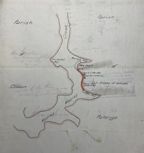
84 Hawkesbury River, Charles Andrew Shattles Brooklyn (oyster lease), SARANSW NRS-1302-3-[10/32071]-12894
85 DC of Elizabeth Bessie Rose 1897/013520.
86 Anglican Parish Register, Bar Island St John, Burials, 1884-1904 (accessed via Ancestry.com on 13 July 2021). Later burials on Bar Island included siblings Eva Isabelle and James Kenneth Green (great-great grandchildren of Granny Sarah). James’ father Joseph acted as undertaker for his son’s burial.
41 An Aboriginal History
Hornsby Shire Local Government Area
Figure 19. Charles Shattles oyster lease, 192484
An Aboriginal History
Hornsby Shire Local Government Area
time: he may have grown food near his residence, as a cottage was built near the church (see Figure 14).87
A provisional school was established on Bar Island in the early 20th century. The family of Moses and Alice Shattles had moved from the island by this time as none of their children were included on the list of prospective students. None of his relative’s children were mentioned either – they may have sent their children to other nearby schools.89
87 BC of Amy Shattles 1898/007127.
88 Photograph taken by Michael Bennett on 14 December 2021. 89 Bar Island School Administrative Records SARANSW 5/14807.2
42
Figure 20. Headstone of Cyril Joseph Rose, Bar Island88
1.14 Traditional Culture
Those living on reserves and outside were able to maintain aspects of traditional culture, including language, spiritual beliefs and ceremony. Significant details of culture in Sydney and throughout NSW were recorded by surveyor turned ethnographer Robert Hamilton Mathews. Born at Narellan, he grew up on the family farm at Mutbilly to the west of Goulburn. Mathews played with local Aboriginal children growing up and later employed Aboriginal men as assistants when surveying farms and towns across the colony. According to historian Martin Thomas, Mathews developed “Ethnomania”, a passion for recording Aboriginal culture, in 1892 after surveying a property at Milbrodale in the Hunter Valley upon which stood a rock shelter decorated with an impressive red and white ochre painting of creation figure Baiami. He devoted the rest of his life to collecting
43
An Aboriginal History Hornsby Shire Local Government Area
Figure 21. Map of Bar Island90
90 Found in Bar Island School Administrative Records SARANSW 5/14807.2
linguistic and cultural information about NSW Aboriginal people, often by meeting with Aboriginal informants in person.91
Mathews did not meet with Aboriginal people within the Hornsby LGA but he did interview some who had a connection to the Dyrubbin River and country in the vicinity of Wisemans Ferry. One of his main language informants was Annie Dillon, sister of Thomas Dillon, who spoke “Darkin-nyoong” and was married to Henry Barber, son of John Luke Barber and Ballandella. Born in the forests and mountains of Wollombi in the mid-1850s (her father was also from that region), Annie had moved to Sackville with her husband by the late 1870s where her children Frederick and John Barber were born. (We will explore more about the lives of Frederick and John below.) Annie also told Mathews about her half-brothers Joseph and John Goobera, with the former providing detailed information about initiation ceremonies of the “Darkin-nyooung tribes”. A fluent speaker, Annie gave three pages of “Darkin-nyoong” words, phrases and grammar which Mathews readily recorded. In later life Annie, known as Granny Barber, moved to La Perouse Aboriginal Reserve where she passed away in February 1915.92
Another of Mathews informants was Charley Clark, also of Wollombi, who with Joseph Goobera provided much of the detail about Darkinjung initiation where young boys were transformed into men. Mathews also learned that Clark was the maker of several hand stencils in a rock overhang near the Dyrubbin. He also instructed Mathews about the correct technique for making rock engravings. Mathews later wrote:
A row of holes was pierced with a piece of pointed stone, establishing the outline of the drawing, after which the intervals between these holes were cut in such a way as to produce an uninterrupted groove.93
Little is known about Charley Clark, although he was living on Sackville Aboriginal Reserve when Mathews visited him. It is an enticing thought that he may have visited one of the many rock engravings near Hornsby to refresh the grooves or make new hand stencils, but this may have been outside his country.
Joseph Goobera (also Gooburra) was born in about 1847, so it is probable that he was initiated at a ceremony held in the late 1850s. The ceremony that he and Clark told Mathew was common to the
91 See Thomas 2011: 56; McBryde 1974 (ADB: https://adb.anu.edu.au/biography/mathews-robert-hamilton-4169/text6693 accessed online 1 September 2021).
92 R.H. Mathews Notebook 7b untitled NLA MS 8006 Series 3, Folder 7; Brooks 1999: 62.
93 Quoted in Thomas 2011:
44 An Aboriginal History Hornsby Shire Local Government Area
“aboriginal (sic) tribes spread over the coastal district of New South Wales, from Newcastle southerly to about Sydney, comprising approximately the Counties of Northumberland, Hunter, Cook and the greater part of the County of Cumberland.” The area includes the Hornsby LGA. The people who participated in the ceremony spoke a variety of languages including Darkinung, Wannungine and “Darrook” (aka Darug).
Neither Goobera nor Clark told Mathews where initiation grounds were located but said that they were always held near where water and “native game” were plentiful. The first group to occupy the location were the hosts; visiting groups took up positions “facing their own country.” Messengers were initially sent to all the groups invited to participate. The messengers stayed with their hosts until the ceremony began and led the line as each group arrived having painted themselves with ochre shortly before. Once all the groups had assembled, some of the men and women would go out each day to hunt, fish and collect vegetable foods. The initiation ground itself consisted of two raised-earth circles connected by a path which varied in size depending on the terrain. It was at these locations that initiates were instructed about their country and eventually had a front tooth removed to signify their initiation. Paths were about 400m in length if the area was scrubby or over 800m if the ground was clear and flat. Near the distant circle, which was generally smaller, were representations of important spirit beings carved into the soil, including “Dhurramoolun” (who is depicted in several rock engravings within the Hornsby LGA). Animals such as the emu, kangaroo, possum and goanna were carved into the bark of nearby trees. A fire was kept burning at the smaller circle 94
It is uncertain when the last initiation ceremony in the vicinity of the Hornsby LGA was held. It would have followed a similar pattern to the one outlined above. Given the detailed knowledge of Charley Clark and Joseph Goobera, they probably attended ceremonies subsequent to their own initiation, possibly into the 1860s and 1870s. Mathews himself documents ceremonies held in various parts of the state in the late 19th and early 20th centuries.
Mathews also documented the Darug language spoken in western Sydney. One of his informants was Sarah Castles who was born at Liverpool in the 1840s. The language was passed down to later generations, including members of the Lock family to whom Sarah was related. Darug Elder Aunty Edna Watson, who lived at Mount Colah as a child (see below), recalled in 2011 that she sometimes met with her grandfather Walter Lock (who was Sarah’s son), either at Mount Colah when he came
45 An Aboriginal History Hornsby Shire Local Government Area
94 Mathews 1897.
to visit or Rooty Hill where he lived. It was during these encounters that she learned that Walter spoke the Darug language.95
1.15 Rural Connections
We saw with the Shattles family that they were able to maintain their fishing traditions and connection to the Dyrubbin River by adapting to the government regulations imposed upon them. By applying for permits, the family operated oyster leases across several generations within the limits of the non-Aboriginal law. Aboriginal people in other parts of NSW sometimes struggled to reconcile their traditions with government rules; one case from northern NSW connects in an unexpected manner to the Hornsby LGA.
In August 1952, two Bundjalung men from the Cabbage Tree Island Aboriginal Reserve on the lower Richmond River, Walter Kapeen and Douglas Cook, were charged with chopping down a tree and eating an old koala.96 It was illegal to eat koalas at the time under the Fauna Protection Act. Kapeen and Cook told the police that they went to Bingal Swamp to look for cobra, a wood-eating worm found in water-swollen logs that was a favourite food. They looked up into the trees and saw two koalas, one aged, the other young about two months old. They chopped down one tree and later cooked and ate the old koala. They took the young koala with them as they “knew it would die if left alone.” Both men protested their innocence arguing that they had eaten koala since they were children and did not know it was wrong. Their protestations mattered little with the judge who convicted them and issued both with £10 good behaviour bonds 97
The authorities struggled with what to do about the young koala. Given its proximity to Cabbage Tree Island, a return to Bingal Swamp was ruled out. They considered taking it to a sanctuary in Brisbane but decided instead to take it south to Bobbin Head where a koala reserve had been established two years before. It is unknown whether they considered the koala park on Castle Hill Road.98
95 Mathews MS 8006. Series 3. Folder 7. Notebook 7b Untitled:23; Salt 2011 7-8.
96 Sydney Morning Herald 23 August 1952: 3. The Cooks and Kapeens continue to live on Cabbage Tree Island to this day, which is now owned by Jali Local Aboriginal Land Council based in Ballina.
97 Sydney Morning Herald 23 August 1952: 3. Kapeen and Cook might face a different outcome today. They could assert a “native title” defence to the charge by demonstrating that koala hunting was a traditional practice taught to them by their family. Such a defence has been used by south coast Aboriginal fishers in recent times and the prosecutions have been withdrawn.
98 Sun 28 April 1950: 10; Macleay Argus 3 September 1952: 4.
46 An Aboriginal History Hornsby Shire Local Government Area
1.16 Surviving Sydney
As we have seen, Aboriginal people from other parts of the colony were brought to Sydney in the 19th century and lived part of their lives in what became the Hornsby LGA. There are similar examples in the 20th century, although many of the details and the circumstances of their arrival are unknown. Such stories exemplify the dislocation from family, cultural and country that many Aboriginal people experienced to varying degrees due to colonisation.
On Monday 2 August 1920, a young Aboriginal man named Darwin Moore appeared in Hornsby Police Court on charges of drunken and disorderly behaviour at the Royal Hotel, Thornleigh, on Saturday 31 July and using indecent language on Pennant Hills Road the same night. Convicted of both charges, Moore faced a fine of 30 shillings or two weeks in gaol.99 It was not the only time that Moore was to appear before a judge.

Darwin Moore was born at Darwin, Northern Territory, in about 1899. The names of his parents are unknown as are the circumstances of his arrival in Sydney, although a National Archives of Australia document indicates that he may have attempted to enlist as a soldier in WWI. He was in Sydney by December 1917 when he witnessed a verbal altercation between two neighbours at Plumpton in western Sydney.101 The complainant was an Aboriginal woman who alleged her neighbour had used
99 Cumberland Argus and Fruitgrowers Advocate 7 August 1920: 8.
100 Long Bay Gaol Photographic Description Book SARANSW 3/6109.
101 Nepean Times 22 December 1917: 2.
47 An Aboriginal History
Hornsby Shire Local Government Area
Figure 22. Gaol Photograph of Darwin Moore, 1923100
racist language against her. Aside from Darwin Moore, one of the witnesses supporting the complainant was Aboriginal woman Mary Stubbings, a descendant of the Locke and Castle families of the Darug people. It seems that Moore was soon able to find other Aboriginal people to interact with after arriving in Sydney.
Moore moved around in Sydney and the central coast in search of work. He was working as a driver in North Sydney in April 1923 when he was arrested for illegally entering a convent. Convicted at North Sydney Police Court, Moore served six months in Long Bay Gaol.102 In April 1926, he was convicted of unlawfully removing oysters from the Parramatta River.103 Moore faced another stint in Long Bay after being found in Kincumber Orphanage in September 1928. Taken to Sydney, he appeared at a Quarter Sessions hearing on 19 September and was sentenced to three months for being found in a building with intent to commit a felony.104 He returned to North Sydney upon release and found work as a delivery bike rider. Moore collided with a pedestrian at the corner of Alfred and High Streets on 8 February 1930. Suffering massive internal injuries, he was taken to the Mater Miseracordiae Hospital, Crows Nest, where he died the next day. The Evening News published a plea for relatives to come forward, but none appeared. Moore was buried in the Church of England Portion of Rookwood Cemetery two days after his death.105
Aboriginal Trackers
Other Aboriginal visitors to the LGA were more engaged with the broader society and economy, including law enforcement. Extensive eucalypt forests and rugged sandstone formations occur throughout the region and many are now contained within national parks, particularly towards the Dyrubbin. Since early colonial times, countless Europeans became lost in the unfamiliar bush. Unable to orient themselves among the trees or move easily across the land, they relied on others, particularly Aboriginal people, to guide and sometimes rescue them. Unfamiliarity with the bush continued into the more recent past and there are several examples in the late 19th and early 20th centuries of Aboriginal trackers investigating crimes and finding the lost. NSW Police regularly employed Aboriginal men (and some women) as trackers from their inception in 1862. Some worked in their traditional country making important contributions to law and order, but others,
102 Long Bay Gaol Photographic Description Book SARANSW 3/6109; Sun 4 May 1923: 7.
103 Sun 1 April 1926: 9.

104 Daily Telegraph 5 April 1928: 4; Long Bay Gaol Photographic Description Book SARANSW 3/6122.
105 Evening News 10 February 1930:7; DC of Darwin Moore 1930/001792.
48 An Aboriginal History
Hornsby Shire Local Government Area
including those mentioned in the following cases, were brought in from elsewhere and adapted their traditional bush skills to work effectively in a different landscape.106
In July 1899, police received a “sensational” report of a robbery on the Galston Road about 4km from Hornsby. In an apparent return to the bush ranging era, “a canvasser and collector employed by a leading sewing machine company” was robbed at gunpoint at a “lonely and wild” spot on Galston Road.107 The thief pointed the muzzle of a revolver at the victim and made off into the scrub, which afforded excellent cover for those on the run, with £2.12.6 in cash. Numerous police were called in to investigate including the tracker based at Parramatta, Jack Redtank (aka Redtank Jack), a Ngiyampaa speaking man from the arid country to the south-west of Cobar. Jack had come to the attention of the police two years before when he found a young girl lost for six days on WTree Station in his traditional country. The police were impressed by his skills and offered him a permanent job as a tracker, first at Bathurst and then, by February 1899, at Parramatta. Jack quickly adjusted his eye to working in the open forests and scrubby country of the undeveloped parts of Sydney: in one case he successfully pursued and caught a jail-escapee in the Camden district. In this instance he was soon on the scene of the robbery looking for signs in the Hornsby bush, but nothing could be found. The search continued into August but was then called off. Jack returned to Parramatta where he remained as tracker until July 1900 when he was taken to the Mudgee district to pursue the Aboriginal fugitives Jimmy and Joe Governor.108
106 For an in-depth discussion of Aboriginal trackers in NSW, see Bennett 2020. I draw a distinction here between trackers who worked for the NSW police and those employed as Native Police, whose specific purpose was to subdue and sometime kill other Aboriginal people.
107 Australian Star 3 August 1899: 5.
108 Evening News 24 July 1902: 3 & 6 September 1899: 6; Cumberland ArgusandFruitgrowers’Advocate 9 June 1900: 4; Police Salary Register 1899 SARANSW 3/2993, Reel 1973; Bennett 2020: 101-02, 290; Pathfinders: Jack Redtankhttps://pathfindersnsw.org.au/placemarks/jack-redtank/. Jack disappears from the record soon after his stint as the Parramatta tracker came to an end. A member of the prominent Keewong family from Ngiyampaa country, he was remembered for his tracking feats, including his pursuit of the Governors, well into the 20th century. Linguist Tamsin Donaldson was told about his “magic eyes” by family members in the early 1980s (Kennedy and Donaldson 1986, transcription of field tapes, AIATSIS, 49-53 LA 9701-9707).
49 An Aboriginal History Hornsby Shire Local Government Area
Sydney was shocked on 19 July 1902 by the murder of a police officer at Redfern. Constables Dennis Guilfoyle and Michael Maher were investigating the use of counterfeit coins when they approached two suspects on Shepherd Street. One of the suspects pulled out a revolver and shot Maher three times. The other suspect, named Shaw, was also armed with a revolver and shot Guilfoyle twice. Maher recovered but Guilfoyle soon died from his wounds. A massive search for the two suspects was quickly launched. On Monday 21 July they were seen buying a copy of the Daily Telegraph and a billy can at a shop near Epping Railway Station. That night they were thought to have camped by a fence between Epping and Cheltenham. The following day they were seen near Hornsby Railway Station heading in the direction of Galston carrying the billy can and a tomahawk. They were later seen near Wisemans Ferry. No doubt they made good use of the tomahawk and billy can when hiding in the bush. The police called in the current Parramatta tracker, an Aboriginal man named G. McCann, to scour the bush between Hornsby and Wisemans Ferry.110 With such a large area to search, McCann, who had replaced Jack Redtank at Parramatta111, was unable to pick up the tracks. He was later called in to investigate a sighting on Woodville Road (originally known as Dog Trap Road), south of Parramatta but again no trace was found. The man who shot Maher was never apprehended (or identified), but Shaw was eventually located in Melbourne. Constable Richard Johnson was called to investigate the attempted abduction of an eight-year-old girl at Elwood (a bayside suburb south of the Melbourne CDB) on 12 October 1902. The suspected abductor was Shaw who drew his revolver and fatally shot Johnson as he approached the scene on his bicycle. Shaw fled
109 Evening News 23 July 1900: 4.
110 Little about G. McCann is known beyond his employment as the Parramatta tracker. McCann is an uncommon name among the Aboriginal families of NSW. A possible candidate is George McCann who was born on the Culgoa River in northwestern NSW in about 1879 to Billy McCann (known as “King of the Barwon Blacks”) and an unnamed mother. As we have seen, residence in distant parts of NSW was not an impediment to working as a tracker in Sydney. George died at Brewarrina on 2 December 1907 (DC of George McCann 1907/012927; DC of Billy McCann 1914/003776).
111 McCann remained as the Parramatta tracker until December 1905 (Police Salary Registers 1902 SARANSW 3/2993, Reel 1973; 1903-1905 SARANSW 11/16337 Reel 1971). Trackers were no longer employed at Parramatta after that time.

50 An Aboriginal History Hornsby Shire Local Government Area
Figure 23. Excerpt from an Evening News article confirming Jack Redtank's transfer to the pursuit of Jimmy and Joe Governor109
but was soon confronted by other police. Before an arrest could be effected, Shaw turned the revolver on himself and committed suicide.112
The tracker who travelled further than others to work in the Hornsby district was Peter Wandy. Born at Kalgoorlie (over 500km east of Perth) in the early 1880s, Wandy remained in the district throughout his youth and worked as the local tracker for four years before taking a job on a cattle station. The physical abuse he suffered from the boss on the station drove him away. After finding his way to Sydney (probably in the early 20th century) and being homeless for a while, Wandy moved to Sackville Aboriginal Reserve. Missionaries from the Australian Inland Mission Christianised him and Wandy became an avid supporter of the church, attending a seminary in Adelaide and preaching both at Sackville and their base at La Perouse. It was from La Perouse in March 1911 that the police called on Wandy to assist in the search for a lost boy at Mount Colah. Three-year-old John Baldwin of Wahroonga had wandered away from his family who were on an outing and become lost in the thick banksia and eucalyptus scrub. Wandy followed the boy’s tracks to a nearby pond and it was feared that Baldwin had fallen in and drowned. 113 The water was dragged but no body was found. Wandy soon picked up the tracks again which headed in a westerly direction down the slope towards Galston. Hopes were growing of a successful conclusion and the boy was found by civilian searchers in an exhausted state after three days in the bush. He was taken by car to Hornsby and treated by Dr Clay. After several hours he was ready to go home.114

112 The Thin Blue Line – Australian Police: https://www.australianpolice.com.au/denis-guilfoyle/; Daily Telegraph 23 July 1902: 7 & 24 July 1902: 5; Sydney Morning Herald 20 October 1902: 6.
113 It is probably that the pond has been subsumed by subsequent urban development at Mount Colah and Hornsby Heights.
114 Telfer 1939; Daily Telegraph 27 March 1911: 9; Sun 25 March 1911: 9; Evening News 25 March 1911: 2. Also see https://pathfindersnsw.org.au/placemarks/peter-wandy/
115 Telfer 1939.
51 An Aboriginal History Hornsby Shire Local Government Area
Figure 24. Peter Wandy115
Peter Wandy never returned home to Western Australia and did not work as a tracker again. After his interest in Christianity waned, Wandy left La Perouse and moved down the south coast of NSW, ending up at Wallaga Lake Aboriginal Station. He contracted pneumonia and died at Bega Hospital without issue in July 1921.116
John Baldwin was not the last person to go missing in rugged and scrubby forests of the Hornsby district. On 23 October 1921, orchardist John Joseph Shakeshaft went missing from his Spencer home on the northern bank of the Dyrubbin near the junction with Mangrove Creek. It was thought that he had gotten lost in the rough and mountainous country near Marra Marra Creek where his brother owned an orchard. Fears were held for his safety as Shakeshaft had a history of poor eyesight. Residents from Spencer and Wisemans Ferry commenced searching and a tracker from the Redfern police depot was called in to assist. The tracker assigned to Redfern in 1921 was Joseph Murray118, a Ngemba man from Bourke in north-western NSW. Murray picked up the tracks on the southern side of the river and followed them for eight miles through thick scrub towards Marra
116 DC of Peter Wandy 1921/011452
117 Sydney Sportsman 28 September 1921: 10. The photograph was taken shortly before Murray began his search for Shakeshaft.
118 Joseph Murray remained at the Redfern depot until at least 1923. One of his main tasks was to break in and train the police horses; he was regarded as an expert in this area. He later returned to Bourke where he was killed by a relative in a domestic dispute in August 1953 (Sunday Times 7 May 1923: 13; Western Herald 7 August 1953: 4).

52 An Aboriginal History
Hornsby Shire Local Government Area
Figure 25. Joe Murray, 1921117
Marra Creek, but Shakeshaft continued to elude his rescuers. As hopes faded – it was thought his body would be found in a ravine - Shakeshaft unexpectedly turned up at home “none the worse for his experiences”. He was unable to account for all the time he was missing, stating that he had no memory of his travels.119
1.17 Child Removal
In the early 20th century, in the era before the APB had the legislative means to intervene, Aboriginal women and children were sometimes institutionalised when no other means of support were available. This was particularly the case for those from outside of Sydney who had no immediate family networks to rely upon. South coast Aboriginal woman, Alice Bolloway, who was born at Moruya in the early 1880s and gave birth to daughter Alice Mary in January 1904 at St Margaret’s Maternity Hospital in Surry Hills. The circumstances of Alice’s arrival in Sydney are unknown, as is the name of her daughter’s father. 120
After the birth, mother and daughter were transferred to the Waitara Foundling Home (not far from Waitara Train Station). Established in 1898 by the Catholic Sisters of Mercy, the home was intended to provide shelter and education for children up to the age of 15 who had either been abandoned by their mothers or were in serious danger. Alice’s case is unusual in that she lived in the home as well as her infant daughter. There are many gaps in the story, however, as it is unclear whether Alice

119 Gosford Times and Wyong District Advocate 3 November 1921: 10, 18; Newcastle Sun 29 October 1921: 5.
120 BC of Alice Mary Bolloway 1904/000236.
121 Hornsby Shire Recollects: https://hornsbyshire.recollect.net.au/nodes/view/2423
53 An Aboriginal History
Hornsby Shire Local Government Area
Figure 26. Waitara Foundling Home, 1900121
eventually left her daughter at the home or whether both departed together. No further trace of either has been found.122
The policy of child removal established by the Aborigines Protection Act 1909 (and strengthened by later amendments) enabled the APB to remove children from the care of their parents and place them in institutions such as the Cootamundra Girls Home, Kinchela Boys Home, Bomaderry Childrens Home123 and others. The Act also established an apprenticeship system where older children were sent to work throughout NSW with non-Aboriginal families until they turned 18. Boys tended to be apprenticed as labourers and girls as domestic servants.
Some children were apprenticed within or nearby to the Hornsby LGA. The earliest known example is a boy from Yulgilbar (on the Clarence River north of Grafton) who was apprenticed at Cheltenham in 1917. A further five girls were placed with Cheltenham families in the 1920s. A 15-year-old-girl from Warangesda (an Aboriginal Station on the Murrumbidgee River in south-western NSW) was apprenticed with a Wahroonga family in October in September 1921. She remained at Wahroonga for 11 months before being transferred to a family at Epping A sixteen-year-old-girl from Roseby Park Aboriginal Station to the east of Nowra was also sent to a Wahroonga family in October 1924 where she remained until May the following year when she was transferred to Walgett. There were at least nine girls and two boys who were apprenticed in Wahroonga during the 1920s. The children came from as far north as Cabbage Tree Island on the Richmond River near Ballina and Wellington in the central west of NSW. Two further girls were apprenticed at Beecroft, one in the early 1920s, the other in the early 1930s. There were four girls apprenticed at Normanhurst in the 1920s, including one who was previously placed at Wahroonga. Records are imperfect and it is probable that there were more, both in the 1920s and subsequent decades. The precise experiences of these children as apprentices are mostly unknown, but numerous studies show that children who were removed suffered emotional trauma and were sometimes subject to physical and sexual abuse by their carers.124
The devastating impact of removal is apparent in the autobiography of Margaret Tucker (nee Clements) who had connection to the Murray River and Wiradjuri country. After being removed and institutionalised at Cootamundra Girls Home, Margaret was one of the children apprenticed to a
122 BC of Alice Mary Bolloway 1904/000236; Hornsby Shire Recollects: https://hornsbyshire.recollect.net.au/nodes/view/2423
123 Non-Aboriginal residents of Hornsby who were part of church networks sometimes sent care packages to institutionalised children. For example, Mrs Summers of Hornsby sent a Christmas package to Bomaderry in December 1938 (The United Aborigines’Messenger 2 January 1939: 8)
124 Elphick and Elphick 2001
54 An Aboriginal History
Hornsby Shire Local Government Area
non-Aboriginal family at Cheltenham (on Beecroft Road) in about 1920. The house overlooked the railway line and Margaret would often watch the trains going by, wishing she could jump on board to be taken “back to my people.” The family she was placed with consisted of two parents and three children. It was Margaret’s responsibility to look after the children, a job which she enjoyed, and also work in the garden. She was not allowed to live in the house; her room was a shed in the garden. Poorly fed and clothed, Margaret suffered numerous physical assaults from the mother After an attempt at self-harm, the APB transferred Margaret to another family where she was treated a little better.125
Despite the traumatic experiences she endured, Margaret maintained a strong sense of compassion and desire to improve the lives of Aboriginal people. She wrote:
I have gone through many awful experiences, and I often wonder what I have learned through them. It has taken me a long time to see, in spite of everything, that bitterness and hate is not the way, but caring for all people, rich or poor, goes a long way to righting wrongs.126
From the 1930s, Margaret joined political organisations aimed at improving the lives of Aboriginal people and reducing government control. She was awarded an MBE in 1968 for her work with Aboriginal organisations.127
It is also known that conditions in the homes and institutions could be horrific at times and unsurprisingly, some children sought to escape and return to their families. In April 1934, Harold Dunn and Alfred Singleton, aged 17 and 16 respectively, escaped from the Gosford Boys’ Home and headed towards Sydney, crossing the Dyrubbin River at Wisemans Ferry.128 What became of Alfred Singleton is unknown, but Harold Dunn, who was born at Brewarrina in about 1917, eventually travelled towards home and married Aboriginal woman Ella Smith at Gulargambone in 1962.129
Aboriginal children continued to be placed in the Waitara Foundling Home after the APB was given the legislative power to seek their removal. A Melbourne women visited the Home in 1917 and noted one Aboriginal infant and another black child from an “island” (possibly the Torres Strait). In September 1949, an Aboriginal man was charged with abducting his two-year-old child from the
125 Tucker 1977: 108-26.
126 Tucker 1977: 118.
127 Farquharson 1996.
128 Newcastle Sun 2 April 1934: 6.
129 MC of Harold Percy Dunn and Ella Jane Smith 1962/015078
55 An Aboriginal History Hornsby
Area
Shire Local Government
home. Details were inconsistently reported by the press. On article suggests that the child was a boy, another a girl. It seems that the father was arrested the following day in Waterloo. What became of the child is less certain. One report suggests that the child was returned to Waitara, another that the mother regained custody. Despite these uncertainties it is apparent that the father sought to regain custody of his child but was thwarted by the authorities. These two cases demonstrate that Aboriginal children were not always sent to exclusively Aboriginal institutions such as Bomaderry, Kinchela or Cootamundra. It makes the task of seeking information about members of the Stolen Generation even more difficult. It is probable that more Aboriginal children were institutionalised at the Waitara Foundling Home than mentioned here.130
1.18 Political Protest
The 1920s and 1930s saw a dramatic rise in organised political campaigns by NSW Aboriginal people seeking to limit the control of the APB over their lives, end child removal, gain recognition of their citizenship and improve their social and economic status. Frederick Maynard, an Aboriginal man from the Upper Hunter River, established the Australian Aboriginal Progressive Association (AAPA) in 1924 to advocate for Aboriginal rights. Although he does not seem to have worked in the Hornsby LGA, Maynard did use his political connections and letter writing skills to campaign in 1927 for Eva Milligan, an Aboriginal woman who lived near the Sackville Reserve. It was reported that their residence was “unfit for such a family to live in” and that their treatment was “evidence of the callousness of Government regarding the welfare of the remnant of the original owners of the country.”131
Although the AAPA folded in the late 1920s, political agitation continued into the next decade and a prominent player in one movement lived in the Hornsby LGA. William “Bill” Townsend Onus, son of William Townsend Onus Snr and Victorian Aboriginal woman Maud Nelson was born at Cummerangunja Aboriginal Station in 1906. He attended the Aboriginal school on the station and the public school at Echuca. After working as a shearer in the Riverina and supplementing his income with prize money earned in athletic events, he married Isabel Patten at West Wyalong in May 1928 before moving to Sydney the following year. An active trade union member, Onus joined the Aborigines Progressive Association (APA) in 1939 and was soon appointed as secretary 132
130 Advocate 15 September 1917: 19; West Australian 12 September 1949: 8; Daily Telegraph 12 September 1949: 6. The Daily Telegraph article states that the child who was taken from the Waitara Foundling Home was initially placed there by her mother. It is also possible that the child was removed by the AWB and then sent to Waitara.
131 Maynard 2007: 98.
132 Ian Howie-Willis, 'Onus, William Townsend (Bill) (1906–1968)', Australian Dictionary of Biography, National Centre of
56 An Aboriginal History Hornsby Shire Local Government Area
Formed several years before by Bill Ferguson, William Cooper and John Patten133, the APA campaigned for equal citizenship rights for Aboriginal people and the abolition of the APB. One of their prominent campaigns culminated in the Day of Mourning held on 26 January 1938, the 150th anniversary of English colonisation. In opposition to government celebrations, Ferguson, Cooper, Patten and many other Aboriginal people marched through the centre of Sydney before holding a rally at Australia House on Elizabeth Street.

From at least 1937 to mid-1940, Onus was living in Copeland Road, Beecroft, at the southern end of Hornsby LGA, shopping at a local grocers on Beecroft Road.135 During the day he worked at the
Biography, Australian National University, https://adb.anu.edu.au/biography/onus-william-townsend-bill-11308/text20185, published online 2000, accessed online 10 August 2021; Broome 2005: 269.
133 John Patten was the father of Bill’s wife Isabel and this relationship probably played a role in his joining the APA.
134 National Museum of Australia – see https://www.nma.gov.au/explore/features/indigenous-rights/people/bill-onus (accessed 26 July 2022).
135 NSW Electoral Roll, Commonwealth Parramatta, State Hornsby, Subdivision of Beecroft (accessed via Trove on 21 January 2021). The name recorded on the roll is William Townsend Onus, which may indicate that the residence was occupied by Bill’s father with whom he shared the same name. Horner, in his account of Onus’ interaction with Bill Ferguson and contribution to the APA, mentions that Onus had a flat in inner-city Newtown in the late 1930s and early 1940s (see Horner 1974: 117). When writing newspaper letters in the early 1940s, Onus consistently gave his address as West Pennant Hills. He may have moved between his Newtown flat and the Copeland Road address Onus undertook divorce proceedings against his wife Isabel
57
An Aboriginal History Hornsby Shire Local Government Area
Figure 27. Bill Onus134
An Aboriginal History
Hornsby Shire Local Government Area

nearby Koala Park on Castle Hill Road carving wooden artefacts for sale and throwing boomerangs for visitors and prominent guests such as former New Zealand Governor General Lord Galway. He had probably learned these skills growing up in Cummeragunja from his parents and others living on the reserve, and he later spoke about how he used boomerangs to hunt ducks on the Murray River Onus used a variety of tools to make the boomerangs including a small saw, wood rasp, tomahawk and sandpaper 136
in early 1940 (they had lived apart since 1935) and initially gave his address as 63 Copeland Road, Beecroft. By September he gave his address as Ryde (Divorce papers William Townsend Onus - Bella Elizabeth Onus SARANSW NRS-13495-16-57978/1940).
136 Pix 26 July 1943: 10-11; Divorce papers William Townsend Onus - Bella Elizabeth Onus SARANSW NRS-13495-16-57978/1940 Bill Onus may not have been the only Aboriginal man to demonstrate boomerang throwing at the koala park. Aboriginal man and Hornsby resident Angel John recalled in 2011 that he was shown how to throw a boomerang at the park by Joe Timbery. With a strong connection to La Perouse and Botany Bay, Joe Timbery ran a boomerang shop and museum on the Loop at the end of Anzac Parade. In 1954, he demonstrated boomerang throwing at the Eiffel Tower in Paris. (Salt 2011: 41; Timbery Boomerangs: https://laperouseheadland.com/tourism/timbery-boomerangs/ (accessed on 25 October 2021).
58
Figure 28. Copeland Road today, near where Bill Onus lived in the late 1930s137
137 Photograph by Coast History and Heritage.
Onus remained at least a part-time resident of Beecroft and continued to work at the Koala Park after joining the APA. In the evenings he often wrote letters to Sydney newspapers about some of the issues faced by Aboriginal people in NSW. In late 1940, he addressed several letters to the Daily Telegraph about the inferior standard of teaching offered to students in schools on Aboriginal reserves (a subject for which he could draw on personal experience). In late October, in response to a comment by Teacher’s Federation president Mr McGuiness, Onus wrote:
Mr McGuiness should know that there is not one fully qualified teacher on any aboriginal reserve in New South Wales. It is any wonder that the children cannot get past third grade? The difference between children on the reserves and those who are educated in the white man’s schools is most marked… When Mr McGuiness claims that the standards of both the aboriginal and white schools are the same, I would ask him to consult members of his organisation. I am sure he will not find one of them teaching in an Aboriginal school.138
The letter prompted a response from Mr Healy, a teacher at the Kyogle Aboriginal Station in northern NSW. Healy, after questioning whether Onus had direct experience, pointed out that some teachers on Aboriginal reserves and stations were fully trained federation members and the equipment was often superior. Undeterred, Onus retorted:
It is absurd to suggest that the equipment in aboriginal schools is better than that in white schools. I am quite certain that the white population would not be satisfied with the inferior teaching accorded aborigines.
Mr Healy might also tell us why it is that aboriginal children do not advance more than they do in their schooling. I have visited four-fifths of the aboriginal reservations in New South Wales, and I am satisfied that in all of them the education standard is inferior.139
In the April the following year, Onus addressed a letter to the Truth on behalf of the APA about recent racist comments by the Mayor of Dubbo. The APA had a strong connection to Dubbo with Ferguson a long-time resident; many of the early APA meetings were also held in the town. In this instance, the Dubbo mayor had commented publicly that the citizens of Dubbo wanted Aboriginal people “kept away” from the town. Onus reminded the Mayor that he had recently taken salutes from a Dubbo AIF unit including three Aboriginal men. He also highlighted the work of the APB in
138 Daily Telegraph 25 October 1940: 6.
139 Daily Telegraph 5 November 1940: 6.
59 An Aboriginal History Hornsby Shire Local Government Area
writing to the government about improved housing educational opportunities for the residents of the Talbragar Aboriginal reserve near Dubbo.140
There were sad times for Onus during his time at Copeland Road, including an event that suggests a close family connection to the Dyrubbin River and the country to the north. His father William Townsend Onus Snr was a resident of the Hornsby Municipality – he may have been living with his son – when he fell ill with heart inflammation and asthma in about September 1937. He was taken to Lidcombe State Hospital and Home, a government asylum for infirm and destitute, where he died aged 70 the following month on 12 October. The funeral took place at Sackville Reach General Cemetery, not far from the Sackville Aboriginal reserve, on 15 October. His death certificate records his place of birth as Hawkesbury River.141 Other documents indicate that he was born at Wollombi (which is about 60km north of Peats Ferry). Onus Snr’s mother was an Aboriginal woman named Martha Hibbs who was born in the 1840s and lived all her life in the Dyrubbin River district.142 It is not known where she was born, but she was also buried at Sackville. Bill Onus is often identified as a Yorta Yorta man through his maternal Victorian connections. It may be the case, however, that he also had a traditional connection to the Dyrubbin through his father. Further research is required to investigate this link.
Bill Onus had left the Hornsby LGA by June 1941 and taken up permanent residence in his Newtown flat. Working as a coke delivery driver for a gas company during the day, Onus remained politically active at night, often hosting Ferguson in his flat for in-depth political discussions. When the delivery job ended, Onus was employed by the APA. Both he and Ferguson campaigned strongly on the issues of school integration and the appointment of an Aboriginal representative to the AWB (as it was called after the 1940 reform). Regarded by some as a radical, Onus often urged Aboriginal people to “depend only on your own exertions.” He sometimes used his union connections to lobby Labor members of Parliament but promises in the back room were often not kept.143 After travelling to Melbourne in March 1946 to address a meeting with Ferguson, Onus seems to have remained in Victoria. He gradually drifted out of politics and concentrated on his business interests, establishing a company that produced and sold Aboriginal artefacts. A return to the political arena in 1967 saw him soon appointed as the first president of the Victorian Aborigines Advancement League and he
140 Truth 27 April 1941: 30.
141 DC of William Onus 1937/021256.
142 Richmond and Windsor Gazette 26 October 1926: 3.
143 Horner 1974: 116-20; Onus was living at 133 Darlington Road, Newtown, when he enrolled to vote in 1943 (NSW Electoral Roll, Commonwealth West Sydney, State Newtown, Subdivision of Newtown North, accessed via Ancestry.com on 21 January 2021)
60 An Aboriginal History
Hornsby Shire Local Government Area
An Aboriginal History Hornsby Shire Local Government Area
campaigned for the “Yes” vote in the 1967 referendum. But his renewed efforts were cut short when he died from a heart attack in January 1968.
144
144 Ian Howie-Willis, 'Onus, William Townsend (Bill) (1906–1968)', Australian Dictionary of Biography, National Centre of Biography, Australian National University, https://adb.anu.edu.au/biography/onus-william-townsend-bill-11308/text20185, published online 2000, accessed online 10 August 2021.
61
Era of Assimilation: 1940-1969
The reforms championed by campaigners such as Bill Onus in the late 1930s were largely unheeded by the Government. Although the axing of the ABP and its replacement by the Aborigines Welfare Board led to some change, including Aboriginal representation, the main policy shift in the early 1940s was from separation and protection towards assimilation. The expectation was that Aboriginal families would eventually merge with the broader non-Aboriginal population and most distinctive cultural practices would disappear. Aboriginal people and culture, however, proved to be resilient.
Assimilation policies encouraged the movement of Aboriginal people from reserves and stations into the broader community. In some instances, this enabled Aboriginal people greater access to services available to the broader community. In July 1958, for example, young Francis Cruse from the NSW south coast was admitted to the Mount Wilga Rehabilitation Hospital at Hornsby to recover from illness 146 Non-Aboriginal people, however, were frequently unwilling to accept the presence

62 An Aboriginal History
Hornsby Shire Local Government Area
Figure 29. Aunty Edna Watson and family c.1980145
145 Photograph courtesy of Aunty Edna’s daughter, Leanne Watson.
146 Dawn August 1958: 21.
of Aboriginal people. This was the experience of Darug Elder Aunty Edna Watson. Born at Blacktown in 1939 to Aboriginal woman Myra Castles and Frederick Upton, Aunty Edna attended Asquith Public School from Year Four after her father found a job as a train driver based at Mount Colah. The family lived in tents beside the train line as there were no rental houses for railway staff in the suburb. She and her siblings endured racist taunts from students and teachers at the school. Her mother was refused credit at a Mount Colah store given to other customers despite always paying the bills. The discrimination continued when Aunty Edna left Asquith Public and went to Hornsby Home Science High School. She left school aged 14 and worked with her brothers at the Waitara dry-cleaners. Her next job was at the Hornsby Knitting Company which was owned by a Jewish family. Aunty Edna reasoned that she did not experience racism there due to the owner’s personal experience of discrimination.147
1.19 Work and Sport
Work and sport continued to be routes into wider societal acceptance and participation, although those involved sometimes lived outside the LGA. Herbert Simms, with strong connections to both La Perouse and the Shoalhaven River, played for the Hornsby Baptist Church Soccer team in 1954. The team was described as successful and Herbert can be seen in a team photograph crouching in the centre holding the ball – his place at the front suggests he was an important playmaker or goalscorer

147 Salt 2011: 4-11.
148 Dawn August 1954: 3.
63
An Aboriginal History Hornsby Shire Local Government Area
Figure 30. Hornsby Baptist Soccer Team, 1954148
Herbert was living at Woollahra in 1954 and travelled on weekends to play. He also found time to travel to Dubbo where an AWB photographer took his picture. Sadly, his brother passed away in March 1955, by which time he was living at Hornsby Hospital where he probably had a job. It is possible that he continued to play soccer as well. His time as a Hornsby resident was short, however, as by the end of the year he had returned to La Perouse where he married a nurse from the nearby Coast Hospital.
It is uncertain whether Herbert experienced the same level of racism as Aunty Edna Watson did in the Hornsby district. He was undoubtedly a resilient man. A survivor of the Stolen Generations (he was institutionalised in Kinchela Boys Home), Herbert went on to have a successful career in the Department of Aboriginal Affairs, Canberra.149

1.20 Continuing Connection
The descendants of Granny Sarah Lewis continued to maintain a connection with the study area, not just along the Dyrubbin River, but near the more populated districts as well. Oysterman Charles Shattles, son of Moses and great-grandson of Granny Sarah, still had numerous oyster leases in the 1950s for which he paid over £10 in rent. Others were in his wife Ivy’s name. He remained a resident on the Dyrubbin into the 1980s, by which time he was over 80. His son Colin also lived on
149 Dawn August 1954: 2-3; Death Certificate of William Norman Simms 1955/002526 (Herbert acted as the informant for the certificate and gave his residence as 10 Palmerston Road, Hornsby, which is the hospital’s address); Kinchela Aboriginal School Admission Register 1923-1962, SARANSW NRS 3931, 1/9814; Canberra Times 7 February 1979: 23.
64
An Aboriginal History Hornsby Shire Local Government Area
Figure 31. Herbert Simms at Dubbo, 1954
the river in the early 1950s (working as a labourer), but had moved to Hornsby by the late 1970s where he worked as a sales representative. Charles Shattle’s second cousin, Matthew Rose, also maintained a long-term connection with the river. Successive electoral rolls from 1932 to 1980 record him as a fisherman at Brooklyn where he also lived with his wife and children. He, too, had a small oyster lease in the mid-1950s for which he paid £1 per year. Mathew earned a living from the river for almost 50 years as his great-grandmother had done over 150 years earlier and his ancestors long before that.150
As was noted earlier in the report, some descendants of Granny Lewis moved into suburban Sydney in the early 20th century. This trend continued as the century progressed. Great grandson Thomas Herbert Bimson, for example, was born at Mona Vale in 1920. Trained as a motor driver and mechanic, Thomas enlisted for WWII on 9 June 1941, serving as a signaller and despatch rider for much of the war at the Bonegilla Army Base, Victoria, near Albury-Wodonga and Royal Park, Adelaide. He also trained despatch riders in Darwin. Following his discharge from the army in November 1945, he returned to the Mona Vale area where he remained for the rest of his life, although his interest in motor cycle racing took him to many rural areas, including Bathurst Despite their travels, the family did not forget their connection to the Dyrubbin River. Thomas’ son Laurie Bimson has run cultural tours since 2009 through Kuring-gai National Park, explaining the cultural significance of the area and showing rock art sites to visitors. He also takes family members to Bar Island to care for the graves and other sites.151
150 Government Gazette 20 July 1956: 2023, 2026; Death Certificate of Charles Andrew Shattles 1985/025838; NSW Electoral Roll, 1977, NSW Berowra (accessed via Ancestry.com on 19 January 2021); NSW Electoral Roll, 1932, Commonwealth Parramatta, State Hornsby, Subdivision of Hornsby (accessed via Ancestry.com on 28 July 2021); NSW Electoral Roll, 1980, Subdivision of Berowra (accessed via Ancestry.com on 28 July 2021). Matthew Rose is also recorded as a Brooklyn fisherman in 1958 and 1972. Tragedy occurred in 1938 when his son Matthew Jnr was struck by a car at Brooklyn while he was securing a punt during a storm. Matthew Jnr was rushed to Hornsby Hospital but could not be saved (Sydney Morning Herald 13 December 1938: 9).
151 Thomas Herbert Bimson service record: NAA: B884, N271880; Laurie Bimson pers. comm., 14 March 2022.
65 An Aboriginal History
Hornsby Shire Local Government Area
Toward Self Determination, 1970-Present
The political advocacy initiated by organisation such as the AAPA and APA from the 1920s onwards continued into the second half of the 20th century and grew into a continent-wide movement as dissatisfaction with government policies deepened. The Federal Council for the Advancement of Aborigines and Torres Strait Islanders was formed in Adelaide in February 1958 to campaign for the abolition of discriminatory legislation and improve the lives of Indigenous people. The Council was closely involved with the 1967 Referendum (which gave the Federal Government power over Aboriginal Affairs) and the Wave Hill walk-off in 1966 led by Vincent Lingiari (which sought equal wages for Aboriginal workers as well as kick-starting the push for land rights in the Northern Territory).152 These events heralded a change in Aboriginal communities and government, with greater emphasis given to self-determination and cultural expression rather than the previous policy of Assimilation. An immediate impact in NSW was the 1970 abolition of the Aborigines Welfare Board. Land rights in NSW soon developed as an important issue: a Lands Trust was formed which saw many of the former reserves and stations transferred to Aboriginal control. Following several years of negotiation, the NSW Aboriginal Land Rights Act (ALRA) was passed by the Wran government in 1983. The ALRA established what is now 120 local land councils across the state, giving each the power to claim crown land in their area deemed not to have an essential public purpose. All Aboriginal people within the boundary of the land council are eligible to join (whether they have a traditional connection to the area or not). The land council for most of the Hornsby LGA is Metropolitan, based in Redfern; small areas fall with Darkinjung and Deerubbin Land Councils Metropolitan have had several successful claims including one at Dural Park.153
The Mabo No. 2 decision by the High Court in 1992 transformed the land rights system across Australia. The decision recognised that Eddie Mabo and associated families had maintained a traditional connection to their lands in the Torres Strait by virtue of their largely unchanged laws and customs. The following year the Keating Federal Government passed the Native Title Act, which established a continent-wide system (excluding Tasmania) whereby traditional owners could apply to the Federal Court to have their ongoing rights to country recognised in Australian law. It is an evidence-based system with claimants having to provide evidence of their connection to meet legal
152 See Dictionary of Sydneyhttps://dictionaryofsydney.org/entry/federal_council_for_the_advancement_of_aborigines_and_torres_strait_islanders (accessed 26 July 2022).
153 See National Native Title Tribunal website: http://www.nntt.gov.au/searchRegApps/NativeTitleClaims/Pages/details.aspx?NTDA_Fileno=NN2001/002
66 An Aboriginal History Hornsby Shire Local Government Area
standards. There have been three claimant applications in the Hornsby LGA including a Darug claim in 1998 (which was settled by an Indigenous Land Use Agreement with the NSW government) and an Awabakal and GuriNgai claim filed in 2013. None were able to gain recognition of native title. Nevertheless, the claims gave the opportunity for traditional owners to assert an ongoing connection to Country.154
The complexities and inadequacies of the land rights systems prompted local Aboriginal people to seek other means to connect with government and educate the public about Hornsby Aboriginal history. Already noted above are the tours run by Bungaree and Granny Sarah Lewis descendant Laurie Bimson in Kuring-gai Chase National Park. The Aboriginal community also successfully lobbied in the early 2000s to establish the Hornsby Aboriginal and Torres Strait Islander Consultative Committee (HATSICC), which meets up to four times each year to provide advice to Hornsby Council on a variety of matters including the protection of cultural heritage and appropriate acknowledgement (there are now signs on each entry road into the LGA acknowledging Daurg and GuriNgai peoples ) It was the work of the committee that led to the present study.
Reconciliation is another significant movement across Australia that gained momentum in the early 1990s with the release of the final report of the Royal Commission into Aboriginal Deaths in Custody in 1991 and the launch of the Bringing Them Home report into the Stolen Generations in 1997.
Reconciliation Australia was formed in 2001 to encourage non-Aboriginal Australians to gain a better understanding of Aboriginal history and build better relationships with the Aboriginal and Torres Strait Islander communities. Even before, however, Aboriginal and non-Aboriginal people were coming together at a local level to promote Reconciliation. The Hornsby Area Residents for Reconciliation (HARR) were formed in the late 1990s. With a mix of Aboriginal and non-Aboriginal membership (the latter predominates), HARR has helped to organise numerous events over the years to promote the cause of Reconciliation and provide information about the history of Aboriginal people locally and across Australia. An important yearly event is the Children’s Voices for Reconciliation which brings together local school choirs and Aboriginal cultural performers at the pedestrian mall on Florence Street, Hornsby, near Westfield Shopping Centre. HARR had also worked with Hornsby Council to install signage acknowledging Traditional Custodians and their deep cultural connection at several sites including the mangrove boardwalk at Brooklyn and Fagan’s Park on the western side of Galston Gorge.
154 See search results from the National Native Title Tribunal website: http://www.nntt.gov.au/searchRegApps/NativeTitleClaims/Pages/default.aspx
67 An Aboriginal History Hornsby Shire Local Government Area
1.21 Population
An outcome of the 1967 Referendum was the inclusion of Aboriginal people in the five-year census count managed by the Australian Bureau of Statistics for the first time since Federation in 1901. Available statistics for the Hornsby LGA show a rise in the number of Aboriginal people since 1996 (see Figure 16)
155
There were 349 (self-identifying) Aboriginal people recorded in 1996, increasing to 447 in 2001 and 2006, 563 in 2011 and 665 in 2016. (Details from the 2021 census will be released later in 2022). The graph shows a steady increase in the number of Aboriginal people within the LGA. Nevertheless, Aboriginal people continue to make up less than 1% of the population. This is lower than the national average, which stands at about 3%. It is reasonable to expect that the number for 2021 will have increased beyond 665, but it is likely that Aboriginal people will continue to make up less than 1% of the overall LGA population.
155 Data from the graph was drawn from the Australian Bureau of Statistics QuickStats web page at https://quickstats.censusdata.abs.gov.au/census_services/getproduct/census/2006/communityprofile/LGA14000?opendocu ment
68 An Aboriginal History Hornsby Shire Local Government Area
Figure 32. Aboriginal people in Hornsby LGA, 1996-2016
349 447 447 563 665 1 HORNSBY ABORIGINAL POPULATION - CENSUS DATA 1996 2001 2006 2011 2016
7 Mar. 1788: Governor Phillip and party explore the lower Dyrubbin River, landing on Mullet Island (later Dangar Island), where they encounter several Aboriginal people painted with white and red ochre.156
June 1789: Smallpox, first noticed on Sydney harbour three months earlier, reaches the Dyrubbin River where is takes a devastating toll on the local Aboriginal population.157
Dec. 1795: Aboriginal warriors attack farms at Sackville Reach. Less than two years later the settlers are gone, the warriors having reclaimed their land.158
Dec. 1796: An Aboriginal girl from near Broken Bay whose parents had been killed in an earlier reprisal raid on the Dyrubbin River is murdered by Aboriginal people from Sydney Cove near the Governor’s residence where she was living.159
Dec. 1804: Governor King meets with three senior Dyrubbin men after violent clashes at Sackville Reach. He promises to stop further settlement downriver where Aboriginal people are taking refuge.160
April 1805: Two salt boilers from Dangar Island are attacked. Aboriginal warriors take their clothes and supplies before sending the men back to Sydney, naked.161
May 1805: Tedbury is apprehended near Pennant Hills after a series of raids on nearby farms. He is taken to Parramatta by a party of constables and settlers.162
156 Bradley 1802 (SLNSW transcript).
157 Karskens 2020: 83; Attenbrow 2002: 21-22.
158 Karskens 2020: 137-38.
159 Collin 1975 (1802) Vol. II: 9.
160 Karskens 2020: 150.
161 Gapps 2018: 167.
162 Sydney Gazette 19 May 1805: 2.
69 An Aboriginal History Hornsby Shire Local Government Area
Timeline
Sept. 1805: Branch Jack, already responsible for several fatal attacks on settlers near Half Moon Bend, is shot when raiding a vessel near Dangar Island. He is presumed dead. Another Aboriginal man, Woglomigh, is also shot and killed.163
Sept. 1816: Daniel Moowattin, an Aboriginal man born at Parramatta in about 1791, works as a labourer on the farm of Bellamy at Pennant Hills. Convicted of rape, he becomes the first Aboriginal person to be executed according to British law.164
1819: French artist Jacques Arago draws Shoalhaven man Broughton (aka Toodwick), who later drives a bullock dray to Alexander Berry’s timber lease at Cowan.165
1820: Many Aboriginal people at Broken Bay and nearby locations perish from influenza.166
1827: Solomon Wiseman is granted a lease of what becomes known as Wisemans Ferry on the Dyrubbin River.167
1829: Reverend John McGarvie compiles a list of Aboriginal places along Dyrubbin including ‘Woolloomoorang’ for Wisemans Ferry and ‘Dooral’ which survives as Dural.168
1829-33: William Govett surveys the lower Dyrubbin River, recording the Aboriginal names for several tributaries (the ‘Cowan’ and ‘Berowra’), investigating several rock engravings and learning about the continued importance of fishing to the Aboriginal economy.169
1833: Two Aboriginal people are observed fishing and collecting fresh water on Berowra Creek. They also set fire to the grass, which quickly engulfs trees as the flames proceed up the slope.170
163 Gapps 2018: 167-68.
164 Sydney Gazette and New South Wales Advertiser 28 September 1816: 1 & 2 November 1816: 2; see also Smith 2010: 11834.
165 Hawkins 1994: 134-35; Bennett 2003; ML PXB 283.
166 Sydney Gazette 16 December 1820: 2.
167 Parsons 1967: 618.
168 McGarvie’s list and Aboriginal Dyrubbin on The Dictionary of Sydney website (https://dictionaryofsydney.org/entry/mcgarvies_list_and_aboriginal_dyarubbin#ref-uuid=15b5b4f7-f0f9-456d-a1219cc96c9c8e01).
169 Govett 1977: 51-54.
170 See Hawkins 2017: 47.
70 An Aboriginal History Hornsby Shire Local Government Area
May 1835: Sarah Lewis is issued with a title for 3 acres of land in the County of Cumberland (probably at Marra Marra Creek).171
Mar. 1836: Sir Thomas Mitchell departs Boree to explore the Lachlan, Murrumbidgee, Murray and Darling Rivers.172
2 May 1836: Aboriginal woman Turandurey joins Mitchell’s expedition downstream from Lake Cargelligo accompanied by her four-year-old daughter Ballandella.173
21 May 1836: Ballandella’s thigh is broken when she falls from the cart and the wheel runs over her leg. The doctor sets the bone and Ballandella is cared for by her mother.174
17 Dec. 1839: Ballandella, under the care of Dr Charles Nicholson, is baptised at Wisemans Ferry.
1840s: A group of Aboriginal people travel from Burns Bay near the mouth of the Lane Cove River to Cowan via Pymble and Cowan Road.175
1842: Nurragingy of South Creek tells Reverend Clarke of Parramatta about the location of “Narrunga Dooral” and “Cobbery Dooral” towards Wisemans Ferry and “Burailllee” (modern-day Berrilee) opposite Berowra.176
May 1844: Ballandella is living and working at a farm house at Milk-maids Reach near Wisemans Ferry.177
15 Apr. 1847: Sarah Wallace (later known as Granny Lewis) marries John Lewis at Marra Marra Creek.178
1851: Mary Ann Lewis, daughter of Sarah Wallace, marries James Shattles at Wisemans Ferry.179
171 Sydney Gazette and New South Wales Advertiser 23 May 1835: 4.
172 http://gutenberg.net.au/ebooks/e00036.html#mitchell2-07
173 Ibid.
174 Ibid.
175 Evening News 22 July 1921: 4.
176 William Branwhite Clarke Papers ML MSS 138/7.
177 The Australian 7 May 1844: 2.
178 MC of John Lewis and Sarah Wallace 1847/286 Vol: 32C.
179 MC of James Nathaniel Shuttleworth and Mary Ann Lewis 327 Vol: 37B; BC of Fanny Shuttle 1864/016294.
71
An Aboriginal History Hornsby Shire Local Government Area
c. 1855: James Frederick Lewis, son of Sarah Wallace, is born at Marra Marra Creek.180
c.1859: Joseph Goubera is initiated at a ceremony held somewhere between the lower Dyrubbin River and the Hunter River. An upper incisor is knocked out as part of the ritual.181
9 May 1861: Sarah Lewis is the midwife for the birth of her grandson Joseph Rose at Berowra, who is the son of John Israel Rose and Elizabeth Lewis.182
c.1862: Moses Shuttles, grandson of Sarah Wallace, is born on Marra Marra Creek.
Aug. 1863: Billy Balah, a young Aboriginal man from the Clarence River on the north coast, plays in a cricket match at Sackville Reach.183
Dec. 1863: Ballandella dies at Sackville Reach on the Dyrubbin River. Her funeral is attended by almost “all the aborigines (sic) on the river” who appear “sorrowful” at her passing 184
19 Oct. 1864 Sarah Wallace acts as midwife for the birth of her granddaughter Fanny Shattles on the Lower Dyrubbin, probably at Marra Marra Creek.185
c.1865: Two or three Aboriginal men are observed living near Hugh Fear’s orchards between present-day Hornsby and Asquith railway stations.186
18 Dec. 1876: Sarah Shattles, granddaughter of Granny Sarah, marries Albert Rogers (nonAboriginal) on Bar Island. There ceremony is conducted by Reverend Henry Britten (who had previously organised blankets for Aboriginal people on the Dyrubbin River) and witnessed by Sarah’s mother Mary Ann Lewis 187
180 DC of James Frederick Lewis 1930/005789.
181 Mathews 1897.
182 BC of Joseph Rose 1861/014068.
183 Sydney Morning Herald 4 August 1863: 2.
184 Sydney Morning Herald 15 December 1863: 5.
185 BC of Fanny Shuttle 1864/016294.
186 CumberlandArgusandFruitgrowers’Advocate 24 August 1907: 10; see also Green 2021: 1, 18-19.
187 ABC Weekly 5 April 1952: 9; Sydney Morning Herald 21 December 1876: 1; MC of Albert Rogers and Sarah Jane Shuttles 1877/004020
72
An Aboriginal History Hornsby Shire Local Government Area
3 Nov. 1877: Albert and Sarah Rogers are living on Bar Island where their daughter Elizabeth Jane is born.
23 Dec. 1879: In what may have been dire economic times for the family, Charles Rogers, son of Sarah Shattles and great-grandson of Granny Sarah Lewis, is born at the Parramatta Destitute Asylum. Mary Ann Lewis follows the tradition of her mother and acts as midwife.188
6 Nov. 1880: Granny Sarah Lewis passes away on Mud Island and is buried two days later on nearby Bar Island in the Dyrubbin River. She is identified as an Aboriginal woman on her death certificate.189
Dec. 1887: Cousins Moses Shattles and Henry Rose apply for oyster leases at Porto Bay and Mooney Mooney Creek respectively.190
18 Sept. 1889: A 150-acre Aboriginal reserve is gazette at Sackville Reach on the Dyrubbin River to the south-west of Wisemans Ferry.191
1892-1897: Ethnographer R.H. Mathews interviews several “Darkin-nyoong” speakers at Sackville Reach Aboriginal Reserve including Annie Dillon (wife of Henry Barber) and Charley Clark, who provide language and cultural information. Clark had recently cut a rock engraving near the Dyrubbin River.192
17 Oct. 1897: Elizabeth Rose (nee Lewis), daughter of Granny Lewis, dies at Peat’s Ferry and is buried two days later in the same cemetery as her mother, Bar Island. Her brother Moses is the sexton for the burial.193
1898-99: Moses Shattles acts as sexton for four burials in Bar Island Anglican Cemetery, a job he performs while living and farming on the island 194
188 BC of Charles Pritchard Rogers 1880/021562.
189 DC of Sarah Ferdinand 1880/009462.
190 New South Wales Government Gazette 6 December & 13 December 1887.
191 Brook 1999: 22.
192 R.H. Mathews Notebook 7b untitled NLA MS 8006 Series 3, Folder 7; Thomas 2011: 56.
193 DC of Elizabeth Bessie Rose 1897/013520; Anglican Parish Register, Bar Island St John, Burials, 1884-1904 (accessed via Ancestry.com on 13 July 2021)
194 Anglican Parish Register, Bar Island St John, Burials, 1884-1904 (accessed via Ancestry.com on 13 July 2021); BC of Amy Shattles 1898/007127
73 An Aboriginal History Hornsby Shire Local Government Area
Mar. 1898: Darkinjung speaker Thomas Dillon calls at the APB office in Central Sydney to make allegations about a European who is camped near to Sackville Reach Aboriginal Reserve. The Board orders local police to investigate.195
Jul. 1899: Tracker Jack Redtank is called in from Parramatta to investigate a robbery on the Galston Road near Hornsby. He searches the scrub for signs of the “bushranger” but finds none. The case goes unsolved.196
27 Jul. 1901: Residents of Sackville Reach Aboriginal reserve hold a concert at Windsor. Performers include Fred and Wes Barber (with ties to Wollombi and McDonald River), Walter Locke (Darug) and others from elsewhere including George Simon (Worimi) and brothers Jack and Walter Campbell (south coast). A feature is songs played on lemon leaves.197
Jul. 1902: Tracker G. McCann, based at Parramatta, scours the bush between Hornsby and Wisemans Ferry for signs of the suspects wanted for the murder of Constable Guilfoyle at Redfern.198
Jan. 1904: South coast Aboriginal woman Alice Bolloway, and her daughter Alice Mary, are institutionalised at the Waitara Foundling Home. Their names disappear from the record after this point.199
26 Dec. 1905: Fred Barber plays a game of “single wicket cricket” at Wisemans Ferry.200
1909: The passage of the Aborigines Protection Act through the NSW Parliament gives the APB the power to remove children, place them in institutions and apprentice them with non-Indigenous families once they reach the age of about 14.
Mar. 1911: Western Australian Aboriginal man and missionary Peter Wandy helps the police to look for a lost child near Mount Colah. Wandy soon picks up the tracks which head
195 Evening News 11 March 1898: 4.
196 Australian Star 3 August 1899: 5; Evening News 24 July 1902: 3 & 6 September 1899: 6.
197 Windsor and Richmond Gazette 27 July 1901: 9.
198 Daily Telegraph 23 July 1902: 7 & 24 July 1902: 5; Sydney Morning Herald 20 October 1902: 6; Police Salary Register 1902 SARANSW 3/2993, Reel 1973.
199 BC of Alice Mary Bolloway 1904/000236.
200 Sydney Sportsman 20 December 1905: 3.
74 An Aboriginal History Hornsby Shire Local Government Area
towards Galston. The child is found in an exhausted state by civilians, but quickly recovers.201
1917: A 12-year-old-boy from Yulgilbar on the Clarence River to the north of Grafton is removed by the APB apprenticed with a non-Indigenous family at Cheltenham.202
Sep 1917: There is at least one Aboriginal infant institutionalised in the Waitara Foundling Home.203
1920s: At least 21 Aboriginal children who had been removed from their families by the APB are apprenticed with non-Indigenous families either within or nearby to the Hornsby LGA.204
c.1920: Margaret Tucker (nee Clements) from the Murray River is apprenticed with as a domestic servant with a non-Aboriginal family at Beecroft Road, Cheltenham where she suffers physical abuse at the hands of the mother.205
2 Aug. 1920: Darwin Moore, an Aboriginal man from the Northern Territory, appears in Hornsby Court and is convicted of drunk and disorderly behaviour, and obscene language at Thornleigh.206
Oct. 1923: Tracker Jospeh Murray, a Ngemba man from Bourke, is called in to look for John Joseph Shakeshaft who was gone missing in the vicinity of Marra Marra Creek. Murray picks up the tracks and follows them for eight miles, but Shakeshaft turns up at home unharmed.207
1924: Charles Shattles, son of Moses Shattles, obtains an oyster lease on Mooney Mooney Creek. His father works as an oyster lease manager, growing and selling vegetables on the side for additional income.208
201 Telfer 1939; Daily Telegraph 27 March 1911: 9; Sun 25 March 1911: 9; Evening News 25 March 1911: 2.
202 Elphick and Elphick 2001.
203 Advocate 15 September 1917: 19.
204 Elphick and Elphick 2001.
205 Tucker 1977: 108-126.
206 Cumberland Argus and Fruitgrowers Advocate 7 August 1920: 8.
207 Gosford Times and Wyong District Advocate 3 November 1921: 10, 18; Newcastle Sun 29 October 1921: 5.
208 Hawkesbury River, Charles Andrew Shattles Brooklyn (oyster lease), SARANSW NRS-1302-3-[10/32071]-12894; Gosford Times and Wyong District Advertiser 18 September 1924: 10.
75
An Aboriginal History Hornsby Shire Local Government Area
9 Feb. 1930: Darwin Moore crashes his bicycle into a pedestrian at North Sydney. He is taken to the nearby Mater Hospital where he dies the following day.209
1932: Matthew Rose, great-grandson of Granny Sarah Lewis, works as a fisherman at Brooklyn.210
April 1934: Harold Dunn and Alfred Singleton, Aboriginal boys aged 17 and 16 respectively, escape from Gosford Boys’ Home and head towards Sydney, crossing the Dyrubbin River at Wisemans Ferry.211
1937: Political campaigner and entrepreneur Bill Onus is living on Copeland Road, Beecroft, and working at the nearby Koala Park making wooden artefacts and throwing boomerangs for visitors.212
c. Sep. 1937: William Townsend Onus Snr, father of Bill Onus and resident of Hornsby Municipality, falls ill and is taken to Lidcombe State Hospital and Home where he dies the following month. Onus Snr is buried on 15 October at Sackville Reach.213
Dec. 1938: Mrs Summers of Hornsby sends a Christmas package to the Aboriginal children institutionalised at the Bomaderry Home.214
Oct-Nov. 1940: Bill Onus writes several letters to the Daily Telegraph lamenting the poor standard of education offered to Aboriginal children on NSW reserves and stations.215
9 June 1941: Thomas Herbert Bimson, great-grandson of Granny Lewis, enlists in WWII at Liverpool, serving as a signaller and mechanic at Bonegilla, Victoria and Royal Park, South Australia.216
1943: Sackville Aboriginal Reserve is revoked after the death of Andy Barber.217
209 Evening News 10 February 1930:7; DC of Darwin Moore 1930/001792.
210 NSW Electoral Roll, 1932, Commonwealth Parramatta, State Hornsby, Subdivision of Hornsby (accessed via Ancestry.com on 28 July 2021).
211 Newcastle Sun 2 April 1934: 6.
212 Pix 26 July 1946: 10-11.
213 DC of William Onus 1937/021256.
214 TheUnitedAborigines’Messenger 2 January 1939: 8.
215 Daily Telegraph 25 October 1940: 6.
216 Thomas Bimson service record: NAA B884, N271880.
217 Karskens 2020: 521.
76
An Aboriginal History Hornsby Shire Local Government Area
Sep. 1949: An Aboriginal father is charged with kidnapping after taking his daughter from the Waitara Foundling Home.218
Aug. 1952: Bundjalung men Walter Kapeen and Douglas Cook are convicted of catching and eating an old koala near their home on the Richmond River. A surviving koala is taken to Sydney and placed in the koala sanctuary at Bobbin Head, which had been established in 1950.219
1954: Herbert Simms, with ties to La Perouse and the Shoalhaven River, plays soccer for the successful Hornsby Baptist team. He travels from his home in Woollahra to play.220
1956: Charles Shattles, great grand-son of Granny Sarah Lewis, pays over £10 per year for his five oyster leases on the Dyrubbin River.
Mar. 1955: Herbert Simms is living (and probably working) at Hornsby Hospital on Palmerston Road.221
Jan. 1968: Political campaigner and entrepreneur Bill Onus dies in Melbourne.222
1980: Matthew Rose is working as a fisherman at Brooklyn, almost 50 years after he was first recorded doing the same job.223
218 West Australian 12 September 1949: 8
219 Sydney Morning Herald 23 August 1952: 3; Sun 28 April 1950: 10; Macleay Argus 3 September 1952: 4.
220 Dawn August 1954: 2-3.
221 See Death Certificate of William Norman Simms 1955/002526.
222 Ian Howie-Willis, 'Onus, William Townsend (Bill) (1906–1968)', Australian Dictionary of Biography, National Centre of Biography, Australian National University, https://adb.anu.edu.au/biography/onus-william-townsend-bill-11308/text20185, published online 2000, accessed online 10 August 2021.
223 NSW Electoral Roll, 1980, Subdivision of Berowra (accessed via Ancestry.com on 28 July 2021).
77 An Aboriginal History
Hornsby Shire Local Government Area
An Aboriginal History
Hornsby Shire Local Government Area
References
Manuscripts
Anglican Parish Registers, Sydney224
Bar Island, St John’s Church, Burials, 1884-1904
Redfern, St Saviour, Baptism, 1880-1916
Australian Electoral Commission
NSW Electoral Rolls, 1932-1980 (accessed via Ancestry.com)
Australian Institute of Aboriginal and Torres Strait Island Studies
Eliza Kennedy and Tamsin Donaldson 1986, transcription of field tapes, AIATSIS, 49-53 LA 9701-9707.
Hawkesbury Library Service
Aboriginal Mission at Sackville Reach: image 000551
National Archives of Australia
Thomas Herbert Bimson service record: B884, N271880
National Library of Australia
R.H. Mathews Notebooks: 7b untitled MS 8006 Series 3, Folder 7
New South Wales Land Registry Services
Crown Plan of part of the Parish of South Colah on Peat's Ferry Road County Cumberland C632-690
State Archives and Records Authority of NSW
1891 Census
Aborigines: Papers dealing with issue of blankets, etc, and including returns of the native population in the various districts, 1833-35, NRS-906-1, Special bundles (Colonial Secretary) [4/6666B]4/6666B.3
224 Available on Ancestry.com.
78
An Aboriginal History Hornsby Shire Local Government Area
Aborigines: Distribution of blankets, 1837-44 for the following districts: Berrima, Brisbane Water, Broulee, Dungog, Hartley, Liverpool, Parramatta, Paterson, Patrick's Plains (including Singleton, Glendon, Wollombi and Dulwich), Picton, Scone, Ulladulla & Wollongong, NRS-9061, Special bundle (Colonial Secretary) [4/1133]-4/1133.3
Bar Island School Administrative Records 1901-03, 5/14807.2
General View from Mooney Mooney Creek (photograph) A97 NRS-20224-1-[18/3061]-A1_A223-28
Kinchela Aboriginal School Admission Register 1923-1962, NRS 3931, 1/9814
Long Bay Gaol Photographic Description Book 3/6109, 3/6122
Police Salary Registers 1899-1902 3/2993, Reel 1973; 1903-1905 11/16337 Reel 1971
Register of Aboriginal Reserves 2/8349 Reel 2847
State Library of New South Wales
Five portraits of Aborigines from around Sydney / five pencil crayon drawings by Jacques Arago PXB
283
Magil, Corroboree dance [c. 1819-20] / [attributed to R.Browne], SV/147
Tracing of Mr Commin's survey of Mullet Island, Hawkesbury River October 7th 1862, Z/M2 811.25/1862/1
William Bradley drawings from his journal `A Voyage to New South Wales', ca. 1802 ML Safe 1/14 (see https://archival.sl.nsw.gov.au/Details/archive/110316551)
William Branwhite Clarke Papers ML MSS 138/7
Unpublished reports and theses
Bennett, Michael 2003. For a labourer worthy of his hire: Aboriginal economic responses to colonisation in the Shoalhaven and Illawarra, 1770-1900. Unpublished PhD thesis, University of Canberra.
Hawkins, Ralph 2017a Aboriginal People of the Bushland Shire Unpublished report supplied by the author.
Hawkins, Ralph 2017b. Normanhurst West. Unpublished report provided to Hornsby Council.
79
An Aboriginal History Hornsby Shire Local Government Area
Richmond, Tom 2015. The Blood of Bungaree: The Story of the Descendants of ‘Granny’ Lewis, GuRing-Gai Woman. Unpublished report provided by Laurie Bimson.
Published books and articles
Bennett, Michael 2020. Pathfinders: A history of Aboriginal trackers in NSW. NewSouth Publising, Sydney.
Bradley, William. 1802 `A Voyage to New South Wales', December 1786 - May 1792; compiled 1802 (media transcript available at https://www.sl.nsw.gov.au/collection-items/william-bradleyjournal-titled-voyage-new-south-wales-december-1786-may-1792)
Brook, Jack 1988. ‘The widow and the child.’ Aboriginal History Vol. 12.
Brook, Jack 1999. Shut Out from the World: The Hawkesbury River Aborigines Reserve and Mission 1889-1946. Sydney: Deerubbin Press (2nd edition)
Broome, Richard 2005. Aboriginal Victorians: A History since 1800. Allen and Unwin, Sydney.
Collins, David 1975 (1802). An Account of the English Colony in New South Wales, With Remarks on the Dispositions, Customs, Manner, etc, of the Native Inhabitants of that country. Facsimile edition published by A.H and A.W. Reed, Sydney.
Currie, Jessica. 2008. Bo-ra-ne ya-goo-na par-ry-boo-go – Yesterday today tomorrow: An Aboriginal history of Willoughby. Chatswood: Willougby City Council.
Elphick, Don and Elphick Beverley gulambali 2001. Aborigines Protection Board and the detail recorded in the Ward Registers. Self-published, Canberra.
Farquharson, John 1996. Tucker, Margaret Elizabeth (Auntie Marge) (1904–1996) Indigenous Australia: https://ia.anu.edu.au/biography/tucker-margaret-elizabeth-auntie-marge-1556.
Gapps, Stephen 2018. The Sydney Wars: Conflict in the early colony 1788-1817. NewSouth Publishing, Sydney.
Gapps, Stephen 2021. Gudyarra: The First Wiradyuri War of Resistance – The Bathurst War, 18221824. NewSouth Publishing, Sydney.
Govett, William Romaine 1977. Sketches of New South Wales, Written and Illustrated for the Saturday Magazine in 1836-37. Gaston Renard Publisher, Melbourne.
80
An Aboriginal History Hornsby Shire Local Government Area
Green, Robert 2021. A History of Asquith, New South Wales. Hornsby Shire Historical Society, Hornsby.
Gunson, Niel 1974. Australian Reminiscences and Papers of L.E. Threlkeld: Missionary to the Aborigines 1824-1859, Vol. 1 & 2. Australian Institute of Aboriginal Studies, Canberra.
Hawkins, Ralph 1994. The Convict Timbergetters of Pennant Hills: A History and Biographical Register. Hornsby Shire Historical Society, Hornsby.
Horner, Jack 1974. Vote Ferguson for Aboriginal Freedom. Australian and New Zealand Book Company, Sydney.
Howie-Willis, Ian 2000. 'Onus, William Townsend (Bill) (1906–1968)', Australian Dictionary of Biography, National Centre of Biography, Australian National University, https://adb.anu.edu.au/biography/onus-william-townsend-bill-11308/text20185
Irish, Paul 2017. Hidden in Plain View: The Aboriginal People of Coastal Sydney. NewSouth Publishing, Sydney.
Karskens, Grace 2020. People of the River: Lost worlds of Early Australia. Sydney: Allen and Unwin, Sydney.
Mathews, R.H. 1897. “The Burbung of the Darkinung Tribes.” Proceedings of the Royal Society of Victoria, Vol.10, No. 1.
Maynard, John 2007. Fight for Liberty and Freedom: The origins of Australian Aboriginal activism. Aboriginal Studies Press, Canberra.
NSW Legislative Council, 1845. “Report from the Select Committee on the Condition of the Aborigines, with appendix, minutes of evidence and replies to a circular letter” Government Printer, Sydney.
Parsons, Vivienne 1967. “Wiseman, Solomon.” In A. Shaw and C. Clark (eds.) Australian Dictionary of Biography, Volume 2: 1788-1850, I-Z. Melbourne University Press, Melbourne.
Richmond, Tom 2002. Granny Lewis of Mother Marrs Creek. Self-published.
Salt, Annette 2011. Still Standing – ‘We are here… and we have always been here’: Life Histories of Aboriginal People associated with the area of the Shire of Hornsby. Deerubbin Press in association with the Hornsby Area Residents of Reconciliation.
81
An Aboriginal History Hornsby Shire Local Government Area
Smith, Keith Vincent 2010. Mari Nawi: Aboriginal Odysseys. Rosenberg, Sydney.
Telfer, Edward 1939. Amongst Australian Aborigines. Self-published.
Thomas, Martin 2011. The Many Worlds of R.H. Mathews: In Search of an Australian Anthropologist Allen and Unwin, Sydney.
Tucker, Margaret 1977. If Everyone Cared: Autobiography of Margaret Tucker Ure Smith, Sydney.
Wafer, Jim and Lissarrague, Amanda 2008. A handbook of Aboriginal languages of New South Wales and the Australian Capital Territory. Muurrbay Aboriginal Language and Culture Co-operative, Nambucca Heads.
Newspapers and Periodicals
ABC Weekly
Advocate (Melbourne)
The Australian Australian Star
Australian Worker
Canberra Times
Cumberland Argus and Fruitgrowers’ Advocate
Cumberland Mercury
Daily Telegraph (Sydney)
Dawn Evening News (Sydney)
Gosford Times and Wyong District Advocate
Government Gazette
Hawkesbury Herald
Macleay Argus (Kempsey)
82
An Aboriginal History Hornsby Shire Local Government Area
Nepean Times
New South Wales Government Gazette
Newcastle Sun
Pix
Windsor and Richmond Gazette
Sands Directory
South Australian Record and South African Chronicle
Sun (Sydney)
Sunday Sun (Sydney)
Sydney Gazette and New South Wales Advertiser
Sydney Morning Herald
Sydney Sportsman
Truth
United Aborigines’ Messenger
Voice of the North
West Australian (Perth)
Western Herald (Bourke)
Websites
Australian Bureau of Statistics – QuickStats: https://quickstats.censusdata.abs.gov.au
Australian Dictionary of Biography: https://adb.anu.edu.au/
The Dictionary of Sydney: https://dictionaryofsydney.org/entry/
Gutenberg: http://gutenberg.net.au/ebooks/e00036.html#mitchell2-07
Historic Lands Record Viewer: https://hlrv.nswlrs.com.au/
83
An Aboriginal History Hornsby Shire Local Government Area
Hornsby Shire Recollects: https://hornsbyshire.recollect.net.au
Indigenous Australia: https://ia.anu.edu.au/
La Perouse Museum and Headland – Timbery Boomerangs: https://laperouseheadland.com/tourism/timbery-boomerangs/
National Museum of Australia: http://nma.gov.au
National Native Title Tribunal: http://www.nntt.gov.au
Pathfinders - A History of NSW Aboriginal Trackers: https://pathfindersnsw.org.au/
State Library of New South Wales: http: //www.sl.nsw.gov.au
State Library of Victoria (digital exhibitions): http://digital.slv.vic.gov.au
The Thin Blue Line – Australian Police: https://www.australianpolice.com.au
Event and Conference Papers
Bishop, Catherine 2021. ‘A Useful Accessory’ with Too Much Cabbage and Jesus Christ’’. Royal Australian Historical Society Event (via Zoom), 12 October 2021
BDM Certificates – Birth
1861/014068 – Joseph Rose
1864/016294 – Fanny Shuttle
1880/021562 - Charles Pritchard Rogers
1895/028447 - Charles Andrew Henry Alexander Shattles
1898/007127 – Amy Shattles
1904/000236 – Alice Mary Bolloway
BDM Certificates – Death
1880/009462 - Sarah Ferdinand
1897/013520 - Elizabeth Bessie Rose
1907/012927 - George McCann
84
1914/003776 - Billy McCann
1921/011452 - Peter Wandy
1923/005503 - Thomas Dillon
1930/001792 - Darwin Moore
1930/005789 - James Frederick Lewis
1937/021256 - William Onus
1955/002526 – William Norman Simms
1985/025838 - Charles Andrew Shattles
BDM Certificates – Marriage
1847/286 Vol: 32C - John Lewis and Sarah Wallace
1851/327 Vol: 37B – James Nathaniel Shuttleworth and Mary Ann Lewis
1962/015078 – Harold Percy Dunn and Ella Jane Smith
85
An Aboriginal History Hornsby Shire Local Government Area
Heritage
Aboriginal
Study Hornsby Local Government Area
Appendix 3: Hornsby Aboriginal heritage places: Summary information
Hornsby LGA: Aboriginal Heritage Study Appendix 3. Aboriginal heritage places: Summary information
Aboriginal heritage places: Summary information
This appendix provides brief additional details for the Hornsby Aboriginal Heritage Places (HAHP) that were identified over the course of the study. Many of these are already listed heritage items, and the listing details are not reproduced, but information and references found during the project research are included. Note that this is not a comprehensive listing of places of Aboriginal heritage significance within Hornsby Shire LGA.

Table of contents
1
HAHP #01: Guragalung Gayanayung (Maroota Historic Site) 5 HAHP #02: Guringai Resting Place - Bujwa Bay............................................................................... 5 HAHP #03: Old Mans Valley Cemetery 5 HAHP #04: Bar Island Cemetery Precinct 6 HAHP #05: Indigenous Place .......................................................................................................... 7 HAHP #06: Indigenous Place .......................................................................................................... 8 HAHP #07: Indigenous Place 8 HAHP #08: Indigenous Place 9 HAHP #09: Ku-ring-gai Chase National Park.................................................................................... 9 HAHP #10: Long Island Nature Reserve 10 HAHP #11: Berowra Valley Regional Park 10 HAHP #12: Bradleys Beach........................................................................................................... 10 HAHP #13: Old Northern Road..................................................................................................... 11 HAHP #14: Dangar Island 11 HAHP #15: Doughboy Beach ........................................................................................................ 12 HAHP #16: King Billy's Camp ........................................................................................................ 12 HAHP #18: Sal's Cave 12 HAHP #19: Sam's Cave 13 HAHP #20: Jack's Rock ................................................................................................................. 13 HAHP #21: Moses Shattles' property 13 HAHP #22: Sarah Ferdinand's property 14 HAHP #23: Bill Onus' residence.................................................................................................... 15 HAHP #24: Brooklyn Cemetery .................................................................................................... 15 HAHP #25: Peats Ferry Road, Hornsby to Peats Ferry 15
2 Hornsby LGA: Aboriginal Heritage Study Appendix 3. Aboriginal heritage places: Summary information HAHP #26: McKell Park................................................................................................................ 16 HAHP #27: Kiparra Park 17 HAHP #28: Frontier conflict site 17 HAHP #29: Frontier conflict site ................................................................................................... 17 HAHP #30: The Jungo 18 HAHP #31: Kangaroo Point 18 HAHP #32: Hawkesbury River 18 HAHP #33: Koala Park.................................................................................................................. 19 HAHP #34: St Mary's Church of England (former)......................................................................... 19 HAHP #35: Hornsby Hospital 20 HAHP #36: Porto Bay ................................................................................................................... 20 HAHP #37: Mount Colah camp..................................................................................................... 20 HAHP #38: Matthew Rose's residence 21 HAHP #39: Waitara Foundling Home 21 HAHP #40: Margaret Tucker's (nee Clements) residence.............................................................. 22 HAHP #41: Cheltenham apprenticeships 22 HAHP #42: Normanhurst apprenticeships 22 HAHP #43: Wahroonga apprenticeships....................................................................................... 23 HAHP #44: Hornsby Police Court.................................................................................................. 23 HAHP #45: Search by Tracker Jack Redtank 24 HAHP #46: Search by Tracker G. McCann..................................................................................... 24 HAHP #47: Search by Tracker Peter Wandy.................................................................................. 24 HAHP #48: Search by Tracker Joseph Murray 24 HAHP #49: Asquith Public School 25 HAHP #50: Hornsby Home Science Secondary School .................................................................. 25 HAHP #51: Waitara Drycleaners................................................................................................... 25 HAHP #52: Hornsby Knitting Company 26 HAHP #53: Hornsby Baptist Church.............................................................................................. 26 HAHP #54: Milson Island.............................................................................................................. 26 HAHP #55: Mount Wilga Private Rehabilitation Hospital 27 HAHP #56: Wiseman's Ferry Oval 27 HAHP #57: Beecroft apprenticeships ........................................................................................... 27 HAHP #58: Metropolitan LALC land claim 28 HAHP #59: Awabakal and Guringai Native Title claim 28
3 Hornsby LGA: Aboriginal Heritage Study Appendix 3. Aboriginal heritage places: Summary information HAHP #60: Darug Native Title claim ............................................................................................. 28 HAHP #61: Mount Kuring-gai Aboriginal Area 28 HAHP #62: Wisemans Ferry 29
Hornsby LGA: Aboriginal Heritage Study

Appendix 3. Aboriginal heritage places: Summary information
4
Figure 1. Hornsby Aboriginal Heritage Places
Hornsby LGA: Aboriginal Heritage Study Appendix 3. Aboriginal heritage places: Summary information
HAHP #01: Guragalung Gayanayung (Maroota
HAHP # 01
Name Guragalung Gayanayung
Maroota Historic Site
Address Maroota
Lot and Deposited Plan
Historic Site)
1/1200952, 2/1200952, 108/752029, 57/752029
NPWS reserve Maroota Historic Site
Heritage listings NPW Act: Aboriginal Place
History (historical notes)
Aboriginal art sites dating from prior to and during early European settlement. The art sites include a rock platform with 85 engravings and 54 grinding grooves, two rockshelters with art and archaeological deposit. One of the engraving sites includes three colonial era Aboriginal engraved motifs of a clothed man and woman and a sailing boat. The Place also includes part of a bora or initiation ground. The Place was nominated by the Metropolitan Local Aboriginal Land Council.
References
‘Guragalung Gayanayung (Maroota Historic Site)’, Aboriginal Place, State Heritage Inventory, https://www.hms.heritage.nsw.gov.au/App/Item/ViewItem?itemId=5063172
AHIMS Site Card #45-2-0016
McDonald, J. 1986. Maroota Historic Site Archaeological Survey. Part 1 ( Report to NSW NPWS)
HAHP #02:
Guringai Resting Place - Bujwa Bay
HAHP # 02
Name Guringai Resting Place - Bujiwa Bay
Address Cowan
Lot and Deposited Plan
Co-ordinates (centre point)
GDA94 / MGA Zone 56
NPWS reserve
Heritage listings
History (historical notes)
Restricted information
Restricted information
Muogamarra Nature Reserve
NPW Act: Aboriginal Place
Repatriation site containing the ancestral remains of GuriNgai Aboriginal people taken in the past and held in museums.
References
‘Guringai Resting Place – Bujiwa Bay’, Aboriginal Place, State Heritage Inventory, https://www.hms.heritage.nsw.gov.au/App/Item/ViewItem?itemId=5062884
HAHP #03: Old Mans Valley Cemetery
HAHP # 03
Name
Old Mans Valley Cemetery
Higgins Family Cemetery
Address Quarry Road, Hornsby NSW
Lot and Deposited Plan Part Lot D DP 318676
Heritage listings
State Heritage Register 01764
Hornsby Local Environmental Plan 2013 Schedule 5 A55
5
History (historical notes)
Hornsby LGA: Aboriginal Heritage Study Appendix 3. Aboriginal heritage places: Summary information
Register of the National Estate 2614 Indicative Place (archive)
A local resident has advised that there are rock engravings located near the sandstone steps (Daniel Avedikian to Laura Fraser, pers.comm., 21/11/2019). These are thought to represent a dog/dingo, two human-like figures, a possible fish or seal, and a possible koala. They are though to date to the period that the stairs were built, in the 1930s.
Dennis Foley has described being taken to Old Mans Valley as a child in the 1950s (Read 2003) His Uncle Gar, a Gaimariagal person, taught him that the dolerite outcrop was a women’s site, related to a male site at a dolerite outcrop near Blacktown. There was formerly a freshwater spring that was guarded by Gurang, the old kangaroo people, and Foley suggested that this may be the origin of the name Old Mans Valley.
References
Listings:
‘Higgins Family Cemetery’, Hornsby Local Environmental Plan 2013 Schedule 5 A55, State Heritage Inventory, https://www.hms.heritage.nsw.gov.au/App/Item/ViewItem?itemId=1780065
‘Higgins Family Cemetery’, Register of the National Estate #2614, Australian Heritage Database, http://www.environment.gov.au/cgibin/ahdb/search.pl?mode=place_detail;search=place_name%3Dhiggins%3Blist_code%3DRNE%3B keyword_PD%3Don%3Bkeyword_SS%3Don%3Bkeyword_PH%3Don%3Blatitude_1dir%3DS%3Blon gitude_1dir%3DE%3Blongitude_2dir%3DE%3Blatitude_2dir%3DS%3Bin_region%3Dpart;place_id= 2614
‘Old Man’s Valley Cemetery’, State Heritage Register 1764, State Heritage Inventory, https://www.hms.heritage.nsw.gov.au/App/Item/ViewItem?itemId=5054914
AECOM Australia. 2015. ‘Hornsby Quarry: Road construction spoil management project - Technical working paper: Aboriginal heritage’. (Report to Roads and Maritime Services).
Guringai Tribal Link Aboriginal Corporation. 2011. ‘Aboriginal cultural heritage impact assessment report: Asset protection zone for Hornsby Aquatic Centre, Hornsby, NSW’. (Report to Hornsby Shire Council).
Guringai Tribal Link Aboriginal Corporation. 2011. ‘Aboriginal cultural heritage impact assessment report: Proposed mountain bike track, Old Man’s Valley, Hornsby, NSW’. (Report to Hornsby Shire Council).
Peter Read. 2003. Haunted earth Sydney: University of New South Wales Press.
HAHP #04: Bar Island Cemetery Precinct
HAHP # 04
Name Bar Island Cemetery Precinct Cemetery, church ruins and memorial
Address Berowra Waters
Lot and Deposited Plan Lots 22A, 23A, 24 DP 752040
Heritage listings
History (historical notes)
Hornsby Local Environmental Plan 2013 Schedule 5 A3 Register of the National Estate 103919
Registered AHIMS sites include a shell midden, and rock engravings and grinding grooves. A record from 1871 indicates that the midden was several feet deep.
6
Hornsby LGA: Aboriginal Heritage Study Appendix 3. Aboriginal heritage places: Summary information
The Aboriginal name of the island is thought to have been Marra Marra It is possible that the island was located on a boundary between language areas
Children of Elizabeth Rose and Mrs Moses Shattles attended school on Bar Island, which operated as a provisional school from 1871 to 1873, and then formally from 1876 to 1892 1876 marriage of Sarah Shattles and Albert Rogers. Sarah and Albert lived on the island, where their daughter Elizabeth Jane Rogers was born in 1897
1880 burial of Sarah Lewis/Ferdinand. The grave is not marked, but the location is known by descendants (Laurie Bimson to Fenella Atkinson, pers.comm., 14/12/22)
1895 burial of Cyril Joseph Rose
1897 burial of Elizabeth Rose (Moses Shattles acting as sexton)
1897-9 Moses Shattles acted as sexton
1898 birth of Amy Shattles (daughter of Moses Shattles)
In 2007, Council undertook work to modify and upgrade the existing walking track on the island, including work to reduce impact on the midden.
Management
Update existing listing
Determine assessment requirements in consultation with HATSICC
References
‘Bar Island Cemetery Precinct’, Register of the National Estate #103919, Australian Heritage Database, http://www.environment.gov.au/cgibin/ahdb/search.pl?mode=place_detail;search=place_name%3Dhiggins%3Blist_code%3DRNE%3B keyword_PD%3Don%3Bkeyword_SS%3Don%3Bkeyword_PH%3Don%3Blatitude_1dir%3DS%3Blon gitude_1dir%3DE%3Blongitude_2dir%3DE%3Blatitude_2dir%3DS%3Bin_region%3Dpart;place_id= 2614
‘Cemetery, Church Ruins and Memorial’, Hornsby Local Environmental Plan 2013 Schedule 5 #A3, State Heritage Inventory, https://www.hms.heritage.nsw.gov.au/App/Item/ViewItem?itemId=1780013
Jean, J. Amanda, and Siobhán Lavelle (Gemray Pty Limited). 1996, ‘Bar Island, Hawkesbury River: Conservation plan’. Report to Hornsby Shire Council
Higginbotham. 2002. Plan of management for Bar Island, Hawkesbury River, near Brooklyn NSW’. Report to Hornsby Shire Council
Metropolitan Local Aboriginal Land Council. 2007. ‘Aboriginal site survey: Bar Island, Hawkesbury River’. (Report to Hornsby Shire Council).
Pittendrigh Shrinkfield Bruce Pty Limited. 2003. ‘Bar Island, Berowra Creek: Plan of management’. Report to Hornsby Shire Council.
Hornsby Shire Council. 2008. ‘Final report for Bar Island Aboriginal and European heritage conservation project: Project number WRK 2007 54’. Report to the Heritage Office.#
NSW Marriage Certificate of Albert Rogers and Sarah Jane Shuttles 1877/004020.
NSW Death Certificate of Sarah Ferdinand 1880/009462. Anglican Parish Register, Bar Island St John, Burials, 1884-1904 (accessed via Ancestry.com on 13 July 2021).
NSW Death Certificate of Cyril Joseph Rose 13509/1895.
NSW Birth Certificate of Amy Shattles 1898/007127.
HAHP #05: Indigenous Place
7
05
HAHP #
Hornsby LGA: Aboriginal Heritage Study Appendix 3. Aboriginal heritage places: Summary information
Name Indigenous Place
Address Canoelands
NPWS reserve Marramarra National Park (likely location)
Heritage listings Register of the National Estate #15878 (archive)
History (historical notes)
No details are provided in the listing.
Image keywords associated with the listing are: Indigenous art, Indigenous rock shelters, Indigenous ceremonial sites.
References
‘Indigenous Place’, Register of the National Estate #15878, Australian Heritage Database, http://www.environment.gov.au/cgi-
bin/ahdb/search.pl?mode=place_detail;search=place_name%3Dindigenous%2520place%3Blga_n ame%3Dhornsby%3Bkeyword_PD%3Don%3Bkeyword_SS%3Don%3Bkeyword_PH%3Don%3Blatitu de_1dir%3DS%3Blongitude_1dir%3DE%3Blongitude_2dir%3DE%3Blatitude_2dir%3DS%3Bin_regio n%3Dpart;place_id=15878
HAHP #06: Indigenous Place
HAHP # 06
Name Indigenous Place
Address Cowan
NPWS reserve Muogamarra Nature Reserve (likely location)
Heritage listings Register of the National Estate #15877 (archive)
History (historical notes)
No details are provided in the listing.
Image keywords associated with the listing are: Indigenous art, Indigenous ceremonial sites.
References
‘Indigenous Place’, Register of the National Estate #15877, Australian Heritage Database, http://www.environment.gov.au/cgi-
bin/ahdb/search.pl?mode=place_detail;search=place_name%3Dindigenous%2520place%3Blga_n ame%3Dhornsby%3Bkeyword_PD%3Don%3Bkeyword_SS%3Don%3Bkeyword_PH%3Don%3Blatitu de_1dir%3DS%3Blongitude_1dir%3DE%3Blongitude_2dir%3DE%3Blatitude_2dir%3DS%3Bin_regio n%3Dpart;place_id=15877
HAHP #07: Indigenous Place
HAHP # 07
Name Indigenous Place
Address Mount Kuring-gai
NPWS reserve Berowra Valley National Park or Ku-ring-gai Chase National Park (likely location)
Heritage listings Register of the National Estate #13695 (archive)
History (historical notes)
No details are provided in the listing.
Image keywords associated with the listing are: Indigenous art, Indigenous ceremonial sites.
References
‘Indigenous Place’, Register of the National Estate #13695, Australian Heritage Database, http://www.environment.gov.au/cgi-
8
Hornsby LGA: Aboriginal Heritage Study Appendix 3. Aboriginal heritage places: Summary information
bin/ahdb/search.pl?mode=place_detail;search=place_name%3Dindigenous%2520place%3Blga_n ame%3Dhornsby%3Bkeyword_PD%3Don%3Bkeyword_SS%3Don%3Bkeyword_PH%3Don%3Blatitu de_1dir%3DS%3Blongitude_1dir%3DE%3Blongitude_2dir%3DE%3Blatitude_2dir%3DS%3Bin_regio n%3Dpart;place_id=13695
HAHP
HAHP #
#08: Indigenous Place
08
Name Indigenous Place
Address Wisemans Ferry
Heritage listings Register of the National Estate #2612 (archive)
History (historical notes)
No details are provided in the listing.
Image keywords associated with the listing are: Indigenous art, Indigenous ceremonial sites.
References
‘Indigenous Place’, Register of the National Estate #2612, Australian Heritage Database, http://www.environment.gov.au/cgibin/ahdb/search.pl?mode=place_detail;search=place_name%3Dindigenous%2520place%3Blga_n ame%3Dhornsby%3Bkeyword_PD%3Don%3Bkeyword_SS%3Don%3Bkeyword_PH%3Don%3Blatitu de_1dir%3DS%3Blongitude_1dir%3DE%3Blongitude_2dir%3DE%3Blatitude_2dir%3DS%3Bin_regio n%3Dpart;place_id=2612
HAHP #09: Ku-ring-gai Chase National Park
HAHP #
Name
09
Ku-ring-gai Chase National Park (1980 boundary)
Ku-ring-gai Chase National Park
Address Ku-ring-gai Chase Road, Bobbin Head
NPWS reserve
Ku-ring-gai Chase National Park
Heritage listings Register of the National Estate 2608 (archive) National Heritage List 105817
History (historical notes)
Since 2009, Traditional Custodian Laurie Bimson (Guringai Aboriginal Tours) has run cultural tours in Ku-ring-gai Chase National Park, References
‘Ku-ring-gai Chase National Park (1980 boundary)’, Register of the National Estate #2608, Australian Heritage Database, http://www.environment.gov.au/cgibin/ahdb/search.pl?mode=place_detail;search=place_name%3Dku-ringgai%3Bkeyword_PD%3Don%3Bkeyword_SS%3Don%3Bkeyword_PH%3Don%3Blatitude_1dir%3DS %3Blongitude_1dir%3DE%3Blongitude_2dir%3DE%3Blatitude_2dir%3DS%3Bin_region%3Dpart;pl ace_id=2608
‘Ku-ring-gai Chase National Park, Lion, Long and Spectacle Island Nature Reserves’, National Heritage List #105817, Australian Heritage Database, http://www.environment.gov.au/cgibin/ahdb/search.pl?mode=place_detail;search=place_name%3Dku-ringgai%3Bkeyword_PD%3Don%3Bkeyword_SS%3Don%3Bkeyword_PH%3Don%3Blatitude_1dir%3DS %3Blongitude_1dir%3DE%3Blongitude_2dir%3DE%3Blatitude_2dir%3DS%3Bin_region%3Dpart;pl ace_id=105817
9
Hornsby LGA: Aboriginal Heritage Study Appendix 3. Aboriginal heritage places: Summary information
HAHP
#10: Long Island Nature Reserve
HAHP # 10
Name Long Island Nature Reserve
Address Brooklyn
Lot and Deposited Plan Lot 873 DP 1194440
NPWS reserve Long Island Nature Reserve
Heritage listings Register of the National Estate 2609 (archive) National Heritage List 105817
Hornsby Local Environmental Plan 2013 Schedule 5 245
References
‘Ku-ring-gai Chase National Park, Lion, Long and Spectacle Island Nature Reserves’, National Heritage List #105817, Australian Heritage Database, http://www.environment.gov.au/cgibin/ahdb/search.pl?mode=place_detail;search=place_name%3Dku-ringgai%3Bkeyword_PD%3Don%3Bkeyword_SS%3Don%3Bkeyword_PH%3Don%3Blatitude_1dir%3DS %3Blongitude_1dir%3DE%3Blongitude_2dir%3DE%3Blatitude_2dir%3DS%3Bin_region%3Dpart;pl ace_id=105817
‘Long Island Nature Reserve’, Register of the National Estate #2609, Australian Heritage Database, http://www.environment.gov.au/cgi-
bin/ahdb/search.pl?mode=place_detail;search=place_name%3Dlong%2520island%3Bkeyword_P D%3Don%3Bkeyword_SS%3Don%3Bkeyword_PH%3Don%3Blatitude_1dir%3DS%3Blongitude_1dir %3DE%3Blongitude_2dir%3DE%3Blatitude_2dir%3DS%3Bin_region%3Dpart;place_id=2609
‘Nature Reserve Bushland’, Hornsby Local Environmental Plan 2013 Schedule 5 #245, State Heritage Inventory https://www.hms.heritage.nsw.gov.au/App/Item/ViewItem?itemId=1780691
HAHP #11: Berowra Valley Regional Park
HAHP # 11
Name
Berowra Valley Regional Park
Address Berowra Waters Road, Berowra
NPWS reserve Berowra Valley Regional Park
Heritage listings Hornsby Local Environmental Plan 2013 Schedule 5 158 (listing now removed)
References
‘Berowra Valley Regional Park’, Hornsby Local Environmental Plan 2013 Schedule 5 #158, State Heritage Inventory, https://www.hms.heritage.nsw.gov.au/App/Item/ViewItem?itemId=1780671
HAHP #12: Bradleys Beach
HAHP # 12
Name
Bradleys Beach
Address 43X Grantham Crescent, Dangar Island NSW 2083
Lot and Deposited Plan Lot 78 DP 10902
Heritage listings Hornsby Local Environmental Plan 2013 Schedule 5 A34
History (historical notes)
The site of the earliest meeting of Aborigines and Europeans on the Hawkesbury, in 1788. The listing includes the remains of a midden.
10
Hornsby LGA: Aboriginal Heritage Study Appendix 3. Aboriginal heritage places: Summary information
Management
Update existing listing
Determine assessment requirements in consultation with HATSICC
References
‘Bradleys Beach’, Hornsby Local Environmental Plan 2013 Schedule 5 #A34, State Heritage Inventory, https://www.hms.heritage.nsw.gov.au/App/Item/ViewItem?itemId=1780048
HAHP #13: Old Northern Road
HAHP #
Name
13
Road, stone wall, bridge, escarpment and drain Old Northern Road
Address Old Northern Road, Wisemans Ferry Road Reserve, Wisemans Ferry
Heritage listings Hornsby Local Environmental Plan 2013 Schedule 5 794 & A69
History (historical notes)
The route of the Great North Road along the ridge at Maroota may follow the alignment of an Aboriginal track. This is suggested by the current name of the locality, Maroota, which may mean ‘place of the road’ (muru meaning ‘road’ and -da meaning ‘place’).
Management
Update existing listing
Determine assessment requirements in consultation with HATSICC
References
Grace Karskens, Edna Watson, Leanne Watson, and Jasmine Seymour. n.d. ‘Dyarubbin: Mapping Aboriginal History, Culture, and Stories of the Hawkesbury River, New South Wales’. https://portal.spatial.nsw.gov.au/portal/apps/MapSeries/index.html?appid=82ae77e1d24140e48 a1bc06f70f74269
‘Road, stone wall, bridge, escarpment and drain’, Hornsby Local Environmental Plan 2013
Schedule 5 #794, State Heritage Inventory, https://www.hms.heritage.nsw.gov.au/App/Item/ViewItem?itemId=1780880
HAHP #14: Dangar Island
HAHP # 14
Name
Address
Dangar Island
Mullet Island
Dangar Island
Heritage listings Includes HAHP #12 Bradleys Beach
History (historical notes)
Reference to an Aboriginal person called Grewin living there in the early 19th century. Also to huts and people painted in ochre being seen in 1788, and others living there in 1820s (on blanket returns), and later in 1889 when the railway went through. Ten Aboriginal people recorded as living there in the 1828 Census.
The site of the earliest meeting of Aborigines and Europeans on the Hawkesbury, in 1788. Three huts recorded at this time. The listing includes the remains of a midden.
Conflict recorded in 1805 on the island and in the river near the island
11
Hornsby LGA: Aboriginal Heritage Study Appendix 3. Aboriginal heritage places: Summary information
References
Hawkins, R. 2017 DRAFT. Aboriginal Life in the Bushland Shire (unpublished manuscript), p.41. Bradley 1802 (SLNSW transcript).
Gapps, Stephen 2018. The Sydney Wars: Conflict in the early colony 1788-1817: 185-86.
Karskens, Grace 2020. People of the River: Lost worlds of Early Australia: 137-38
HAHP #15: Doughboy Beach
HAHP #
Name
15
Doughboy Beach
Address Fiddletown
NPWS reserve Marramarra National Park
Heritage listings
History (historical notes)
None
Granny Lewis' son-in-law John Israel Rose lived at Doughboy Beach and was regularly visited by up to 70 Aboriginal people, possibly from Granny Lewis camp or elsewhere.
References
Hawkins, R. 2017 DRAFT. Aboriginal Life in the Bushland Shire (unpublished manuscript), p.50.
HAHP #16: King Billy's Camp
HAHP #
Name
16
King Billy's Camp
NPWS reserve Berowra Valley National Park
Heritage listings
History (historical notes)
Within HAHP #11 Berowra Valley Regional Park
Billy's camp was in a rockshelter along Berowra Creek. King Billy and others into the 1860s and 1870s used to travel to Dural to trade. Billy's wife Sal and Sam used to live in other nearby shelters.
References
Schweikert, H. 1977. ‘Jack's Rock', Local Colour (July/September):4-5
Hornsby Shire Historical Society, 1979. Pioneers of Hornsby Shire 1788-1906 (Sydney, Library of Australian History), p. 15.
HAHP #18: Sal's Cave
HAHP #
18
Name Sal's Cave
Address Berowra Heights
NPWS reserve Berowra Valley National Park
Heritage listings
History (historical notes)
Within HAHP #11 Berowra Valley Regional Park
Sal, wife of Billy lived in rockshelter along Berowra Creek at Sams Creek, immediately above Billy's shelter. Sam used to live in another nearby shelter.
References
Schweikert, H. 1977. ‘Jack's Rock', Local Colour (July/September):4-5
12
Hornsby LGA: Aboriginal Heritage Study Appendix 3. Aboriginal heritage places: Summary information
HAHP #19: Sam's Cave
HAHP # 19
Name Sam's Cave
Address Mount Kuring-gai
NPWS reserve Berowra Valley National Park
Heritage listings
History (historical notes)
Within HAHP #11 Berowra Valley Regional Park
Sam lived in a rock shelter, on the southern shore of Berowra Creek, near the rock shelters used by Billy and Sal
References
Schweikert, H. 1977. ‘Jack's Rock', Local Colour (July/September):4-5
HAHP #20: Jack's Rock
HAHP # 20
Name Jack's Rock
Address Berowra Heights
NPWS reserve Berowra Valley National Park
Heritage listings Within HAHP #11 Berowra Valley Regional Park
History (historical notes)
Said to be a rock shelter where an Aboriginal man named ‘Jack' lived, and fished off Jack’s Rock. Timing not specified but likely to be mid to late 19th century.
References
Schweikert, H. 1977. ‘Jack's Rock', Local Colour (July/September):4-5
HAHP #21: Moses Shattles' property
HAHP # 21
Name Moses Shattles' property
Address Marramarra Creek, Fiddletown
Lot and Deposited Plan Lot 7 DP 654708, Lots 21 & 22 DP 625103, Lots 2-8 & 8A DP 9765, Lots 19 & 20 DP 631782, Lots 11-14 DP 9765, Lots 15-23 DP 16074
NPWS reserve Part within Marramarra National Park
Heritage listings
History (historical notes)
None
40 acres at Peat’s Bight at the mouth of Marra Marra Creek. Home of Moses and Alice Shattles and their four children. Moses Shattles (c.1862-) was a grandson of Sara Wallace. Moses Shattles married non-Indigenous woman Alice Byrnes at Sydney on 22 July 1886. The couple settled near Peat’s Bight on the Dyrubbin River on 40 acres conditionally purchased in Moses’ name. Although not unprecedented, a conditional purchase by an Aboriginal person was rare in the late 19th century – perhaps Moses suppressed his Aboriginality to obtain the land. His selection was at the mouth of Marra Marra Creek, not far from where he was born. Alice gave birth to their four children at home, including Charles on 5 August 1895. They were taken to St Saviour’s Anglican Church, Redfern, for baptism. Inaccessible by road, it is probable that the family travelled by water for at least some of the journey into the centre of Sydney, or by
13
Hornsby LGA: Aboriginal Heritage Study Appendix 3. Aboriginal heritage places: Summary information
train from Brooklyn.
History (historical themes)
Aboriginal post-contact
Aboriginal cultures and interactions with other cultures
Statement of significance
The site has the potential for historical archaeological remains relating to the occupation by Moses Shattles and his family in the late nineteenth century. It is of local heritage significance, as a rare instance of Aboriginal ownership of land (under non-Indigenous title) in the late 19th Century, and due to its association with a family of importance in the history of the local area
Heritage assessment criteria
A The site is important as an element of the post-contact Aboriginal history of the local area.
B The site is associated with Moses Shattles and his family, descendants of Sarah Wallace. The family is of importance in the Aboriginal history of the local area. Members of the family, including Moses Shattles himself, were also prominent local identities in the broader community.
C
D The site is associated with members of the local Aboriginal community who trace their ancestry to Sarah Wallace, and provides a tangible
E The site may retain historical archaeological remains deriving from the occupation by Moses Shattles and his family in the late nineteenth century. Any such remains have the potential to provide historical evidence that is not available from other sources.
F The site is a rare instance of Aboriginal ownership of land (under the introduced system) in the late 19th century.
G Management
New listing: Archaeological Site (for those parts of the property that fall outside Marramarra National Park) to be included in Hornsby Local Environmental Plan 2013 Schedule 5
Determine assessment requirements in consultation with HATSICC
References
County of Cumberland, Parish of Berowra map, edition no. 5 (accessed via Historic Lands Record Viewer).
HAHP #22: Sarah Ferdinand's property
HAHP # 22
Name Sarah Ferdinand's property
Address Fiddletown
Lot and Deposited Plan Lot 2 DP 752014
NPWS reserve Marramarra National Park
Heritage listings
History (historical notes)
None
Lived on a property at Marra Marra Creek from the early 1820s, title for three additional acres issued to Lewis (then Wallace) in 1835.
Sarah Wallace occupied land on Marramarra Creek with her husband John Ferdinand.
14
Hornsby LGA: Aboriginal Heritage Study Appendix 3. Aboriginal heritage places: Summary information
James Lewis, 10th child of Sarah Wallace, was born on Marramarra Creek.
References
Hawkins, R. 2017 DRAFT. Aboriginal Life in the Bushland Shire (unpublished manuscript), p.49, 50, 56
Sydney Gazette and New South Wales Advertiser 20 December 1834: 4 & 23 May 1835: 4.
NSW Death Certificate of James Frederick Lewis 1930/005789.
HAHP #23: Bill Onus' residence
HAHP #
23
Name Bill Onus' residence
Address 63 Copeland Street, Beecroft
Heritage listings
History (historical notes)
None
Residence of Bill Onus (political activist) from at least 1937 to mid-1940. Working at the nearby Koala Park during the day, Onus wrote letters to Sydney newspapers at night addressing several issues facing Aboriginal people including the poor quality of education on Aboriginal reserves.
References
NSW Electoral Roll, 1937, Commonwealth Parramatta, State Hornsby, Subdivision of Beecroft (accessed via Trove on 21 January 2021).
Divorce papers William Townsend Onus - Bella Elizabeth Onus SARANSW NRS-13495-16-57978/1940.
HAHP #24: Brooklyn Cemetery
HAHP #
24
Name Brooklyn Cemetery
Address Brooklyn Road, Brooklyn
Lot and Deposited Plan Lot 7031, DP 1076532; Lot 7049 and 7050, DP 1076533; Lot 395, DP 46975
Heritage listings
History (historical notes)
Hornsby Local Environmental Plan 2013 Schedule 5 204 and A13
Burial place of a child or children of Moses Shattles (descendant of Sarah Lewis).
Management
Update existing listing
Determine assessment requirements in consultation with HATSICC
References
‘Brooklyn Cemetery’, Hornsby Local Environmental Plan 2013 Schedule 5 204, State Heritage Inventory, https://www.hms.heritage.nsw.gov.au/App/Item/ViewItem?itemId=1780039
HAHP #25: Peats Ferry Road, Hornsby to Peats Ferry
HAHP # 25
Name Peats Ferry Road, Hornsby to Peats Ferry
Peats Ferry Road (former) Peats Ferry Road remains
Address Brooklyn, Cowan
15
Hornsby LGA: Aboriginal Heritage Study Appendix 3. Aboriginal heritage places: Summary information
Old Peats Ferry Road (disused)
Lot and Deposited Plan Road reserve
NPWS reserve Part within Muogamarra Nature Reserve
Heritage listings
History (historical notes)
Transport for NSW s170 Heritage and Conservation Register
Hornsby Local Environmental Plan 2013 Schedule 5 A20 & A29
Route showed to George Peat by Boio (also known as Long Dick)
The listing details in the Hornsby Shire Council Heritage Register note: ‘association of the road with the integration of European settlement into areas of Indigenous Australians’ habitat’.
Management
Update existing listing
Determine assessment requirements in consultation with HATSICC
References
‘Peats Ferry Road (Former)’, Transport for NSW s170 Heritage and Conservation Register, State Heritage Inventory, https://www.hms.heritage.nsw.gov.au/App/Item/ViewItem?itemId=4311605
‘Peats Ferry Road Remains’, Hornsby Local Environmental Plan 2013 Schedule 5 A20, State Heritage Inventory, https://www.hms.heritage.nsw.gov.au/App/Item/ViewItem?itemId=1780041
‘Peats Ferry Road Remains’, Hornsby Local Environmental Plan 2013 Schedule 5 A29, State Heritage Inventory, https://www.hms.heritage.nsw.gov.au/App/Item/ViewItem?itemId=1782196
‘Peats Ferry Road Remains’, Hornsby Local Environmental Plan 2013 Schedule 5 A29, Hornsby Shire Council Heritage Register, https://hscenquiry.hornsby.nsw.gov.au/pages/xc.track.heritage/heritage.aspx?id=20803
HAHP #26: McKell Park
HAHP #
Name
26
McKell Park
Address Dangar Road, Brooklyn
Lot and Deposited Plan Lot 7016 DP 1058527
Heritage listings
History (historical notes)
Hornsby Local Environmental Plan 2013 Schedule 5 A14 Hornsby Local Environmental Plan 2013 Schedule 5 225
A rock shelter with potential archaeological deposit has been identified in the park, but appears not to have been registered on AHIMS.
Rail workers camps in the park from the late 1880s and late 1930s/early 1940s may have included Indigenous workers.
Management
Update existing listing
Determine assessment requirements in consultation with HATSICC
References
‘McKell Park - lower, upper, cabbage palms and WWII gun and emplacements’, Hornsby Local Environmental Plan 2013 Schedule 5 #225, State Heritage Inventory, https://www.hms.heritage.nsw.gov.au/App/Item/ViewItem?itemId=1780696
ERM Australia. 2001. ‘Aboriginal heritage study for McKell Park, Brooklyn: Preliminary investigation’. (Report to Pittendrigh Shinkfield and Bruce).
16
Hornsby LGA: Aboriginal Heritage Study Appendix 3. Aboriginal heritage places: Summary information
HAHP #27: Kiparra Park
HAHP # 27
Name Kiparra Park Kilparra Park Bushland
Address 91X Riverview Avenue, Dangar Island
Lot and Deposited Plan Lot 2 DP 537659, Lots 129-135 & 156-195 DP 11921
Heritage listings Hornsby Local Environmental Plan 2013 Schedule 5 334
History (historical notes)
Kiparra Park is known to be of Aboriginal heritage significance. Details of the significance that can be included in the updated listing should be confirmed with HATSICC, GuriNgai and Darug representatives, and the Dangar Island Historical Society.
Management
Update existing listing
Determine assessment requirements in consultation with HATSICC
References
‘Kilparra Park Bushland’, Hornsby Local Environmental Plan 2013 Schedule 5 #334, State Heritage Inventory, https://www.hms.heritage.nsw.gov.au/App/Item/ViewItem?itemId=1780705
HAHP #28: Frontier conflict site
HAHP #
Name
28
Frontier conflict site
Address Canoelands (approximate)
Heritage listings
History (historical notes)
None
Frontier conflict Dyarubbin near Mangrove Creek Early September 1805. Warriors Woglomigh and Branch Jack were both shot in the head while attempting to take over a colonial vessel moored near Mangrove Creek, around 1 September 1805. The whites thought Branch Jack would die, but he survived.
References
Karskens, Grace, Edna Watson, Leanne Watson, and Jasmine Seymour. n.d. ‘Dyarubbin: Mapping Aboriginal History, Culture, and Stories of the Hawkesbury River, New South Wales’. https://portal.spatial.nsw.gov.au/portal/apps/MapSeries/index.html?appid=82ae77e1d24140e48 a1bc06f70f74269
Gapps, Stephen 2018, The Sydney Wars – Conflict in the Early Colony, 1788-1817: 185-86.
HAHP #29: Frontier conflict site
HAHP # 29
Name
Frontier conflict site
Address Wisemans Ferry (approximate)
Heritage listings
History (historical notes)
None
Frontier conflict Dyarubbin near Gunanday December 1805. Warriors attacked the ship Resource, December 1805. The ship was hit by a shower of large stones thrown with force from the cover of dense forest at 'the First Branch', Gunanday, now the Macdonald River.
17
Hornsby LGA: Aboriginal Heritage Study Appendix 3. Aboriginal heritage places: Summary information
References
Karskens, Grace, Edna Watson, Leanne Watson, and Jasmine Seymour. n.d. ‘Dyarubbin: Mapping Aboriginal History, Culture, and Stories of the Hawkesbury River, New South Wales’. https://portal.spatial.nsw.gov.au/portal/apps/MapSeries/index.html?appid=82ae77e1d24140e48 a1bc06f70f74269
HAHP #30: The Jungo
HAHP # 30
Name The Jungo
Address Schofields Trail, Benowie Walking Track, Pennant Hills (Cherrybrook, Westleigh)
NPWS reserve Berowra Valley National Park
History (historical notes)
There is some suggestion the area was once used as a campsite by Aboriginal people.
References
‘Self guided bushwalks: Callicoma Walk’, Discover Hornsby, http://discoverhornsby.com/wpcontent/uploads/2017/05/HSC01849-Self-Guided-Maps_Callicoma_FA.pdf
HAHP #31: Kangaroo Point
HAHP # 31
Name Kangaroo Point
Address Pacific Highway, Brooklyn
Lot and Deposited Plan Lot 1, DP 740853; public reserve and Crown land
Heritage listings
History (historical notes)
Hornsby Local Environmental Plan 2013 Schedule 5 A21 Hornsby Local Environmental Plan 2013 Schedule 5 99
Charles Shattles, son of Moses Shattles, worked as the toll collector at Peats Ferry in the mid-20th century.
Management
Update existing listing
Determine assessment requirements in consultation with HATSICC
References
‘Kangaroo Point’, Hornsby Local Environmental Plan 2013 Schedule 5 #99, State Heritage Inventory, https://www.hms.heritage.nsw.gov.au/App/Item/ViewItem?itemId=1782165
HAHP #32: Hawkesbury River
HAHP # 32
Name Hawkesbury River
Heritage listings None
History (historical notes)
Known to Darug People as Dyrubbin. A focal point for the lives of Sarah Lewis and her descendants.
See also: HAHP #04
18
Hornsby LGA: Aboriginal Heritage Study Appendix 3. Aboriginal heritage places: Summary information
HAHP #10
HAHP #12
HAHP #14-22
HAHP #28-29
HAHP #31
HAHP #36
HAHP #54
References
See Appendix 2
HAHP #33: Koala Park
HAHP # 33
Name Koala Park
Koala Park Wildlife Sanctuary Grounds
Address 84 Castle Hill Road, West Pennant Hills
Lot and Deposited Plan Lots 1–3, DP 357453; Lot 1, DP 135392
Heritage listings Hornsby Local Environmental Plan 2013 Schedule 5 786
History (historical notes)
Late 1930s. Bill Onus, political activist, worked here, carving wooden artefacts for sale, throwing boomerangs for visitors.
Management
Update existing listing
Determine assessment requirements in consultation with HATSICC
References
‘Koala Park Wildlife Sanctuary Grounds’, Hornsby Local Environmental Plan 2013 Schedule 5 #786, State Heritage Inventory, https://www.hms.heritage.nsw.gov.au/App/Item/ViewItem?itemId=1780875
Pix 26 July 1946: 10-11
HAHP #34: St Mary's Church of England (former)
HAHP # 34
Name St Mary's Church of England (former)
Address 156A Brooklyn Road, Brooklyn
Lot and Deposited Plan Lot 9 Sec 2 DP 2105
Heritage listings Hornsby Local Environmental Plan 2013 Schedule 5 219
At least five children from local Aboriginal families were baptised at the church between 1902 and 1909
Management
Update existing listing
Determine assessment requirements in consultation with HATSICC
References
‘St Mary's Church of England (former)’, Hornsby Local Environmental Plan 2013 Schedule 5 #219, State Heritage Inventory, https://www.hms.heritage.nsw.gov.au/App/Item/ViewItem?itemId=1780493
19
Hornsby LGA: Aboriginal Heritage Study Appendix 3. Aboriginal heritage places: Summary information
HAHP #35: Hornsby Hospital
HAHP # 35
Name
Hornsby Hospital
Address 38-76 Palmerston Road, Hornsby
Lot and Deposited Plan Lot 8118 DP 1237240
Heritage listings
History (historical notes)
Hornsby Local Environmental Plan 2013 Schedule 5 529
An Aboriginal employee & several Aboriginal people who worked there. Residence (and probable workplace) of Herbert Simms in c.1955.
Management
Update listing
Determine assessment requirements in consultation with HATSICC
References
Hornsby Local Environmental Plan 2013 Schedule 5 #529, State Heritage Inventory, https://www.hms.heritage.nsw.gov.au/App/Item/ViewItem?itemId=1780928
NSW Death Certificate of William Norman Simms 1955/002526
HAHP #36: Porto Bay
HAHP #
36
Name Porto Bay
Address Porto Bay
Heritage listings None
History (historical notes)
1887 Moses Shattles applied to the Department of Fisheries for a 300 acre oyster lease at Porto Bay. No record has been found of whether it was granted.
References
New South Wales Government Gazette 6 December 1887 & 13 December 1887.
HAHP #37: Mount Colah camp
HAHP #
Name
37
Mount Colah camp
Address Mount Colah
Lot and Deposited Plan Exact location not known
Heritage listings
History (historical notes)
None
From c1950 camp of Myra and Frederick Upton and family, including Edna Watson, beside the train line.
References
Salt, Annette 2011. Still Standing – ‘We are here… and we have always been here’: Life Histories of Aboriginal People associated with the area of the Shire of Hornsby: 4-11.
20
Hornsby LGA: Aboriginal Heritage Study
Appendix 3. Aboriginal heritage places: Summary information
HAHP #38: Matthew Rose's residence
HAHP # 38
Name Matthew Rose's residence
Address 37 Brooklyn Road, Brooklyn
Lot and Deposited Plan Lot 110 DP 603686
Heritage listings None
History (historical notes)
1932-1980 Matthew Rose, a descendant of Sarah Lewis,was a fisherman at Brooklyn, lived here with his family, oyster lease in the mid-1950s
References
NSW Electoral Roll, 1977, NSW Berowra (accessed via Ancestry.com on 19 January 2021)
NSW Electoral Roll, 1932, Commonwealth Parramatta, State Hornsby, Subdivision of Hornsby (accessed via Ancestry.com on 28 July 2021)
NSW Electoral Roll, 1980, Subdivision of Berowra (accessed via Ancestry.com on 28 July 2021)
HAHP #39: Waitara Foundling Home
HAHP # 39
Name Waitara Foundling Home
Our Lady of Mercy Home, Waitara
Address 2 McAuley Place, Waitara
Lot and Deposited Plan SP18027
Heritage listings None
History (historical notes)
Aboriginal residents include:
1904 Alice Bolloway and her newborn Alice Mary
1917 at least two Indigenous children
1949 Aboriginal man took his two-year-old child from the home
1970 removal for adoption of Lynda Yarnold’s baby son
History (historical themes)
Aboriginal post-contact
Aboriginal cultures and interactions with other cultures
Statement of significance
The former Home is significant as an institution where care was provided to Aboriginal mothers and young children. it is a local instance of broader policies of Government involvement in Aboriginal lives. It is associated with Aboriginal parents and children who may identify as members of (or affected by) the Stolen Generations.
Heritage assessment criteria
A
The site is a local instance of a broader policy of Government interference in Aboriginal lives.
B The site is associated with Aboriginal parents and children who may identify as members of (or affected by) the Stolen Generations.
D
The site may be of importance to Aboriginal people whose family members lived at the Home.
21
C
E
Hornsby LGA: Aboriginal Heritage Study Appendix 3. Aboriginal heritage places: Summary information
F The site may retain historical archaeological remains related to the development and occupation of the Waitara Foundling Home. The remains are unlikely to relate directly to the Aboriginal people who are known to have lived at the Home, but would provide information about the conditions and facilities that they experienced.
G Management
New listing: Archaeological Site to be included in Hornsby Local Environmental Plan 2013 Schedule 5
Determine assessment requirements in consultation with HATSICC
References
GML Heritage. 2021. ‘Hornsby thematic history’. Report to Hornsby Shire Council.
NSW Birth Certificate of Alice Mary Bolloway 1904/000236.
Advocate 15 September 1917: 19.
West Australian 12 September 1949: 8.
Daily Telegraph 12 September 1949: 6.
HAHP #40: Margaret Tucker's (nee Clements) residence
HAHP # 40
Name Margaret Tucker's (nee Clements) residence
Address Beecroft Road, Cheltenham
Heritage listings None
History (historical notes)
Margaret Tucker (nee Clements) was removed from her family by the Aborigines Protection Board and worked as an apprentice to a non-Aboriginal family from c.1920.
References
Hawkins n.d. ‘Aboriginal life in the bushland shire’ Tucker, Margaret 1977. If Everyone Cared: Autobiography of Margaret Tucker: 108-26.
HAHP #41:
Cheltenham apprenticeships
HAHP # 41
Name Cheltenham apprenticeships
Address Cheltenham (exact locations not known)
Heritage listings None
History (historical notes)
Aboriginal children placed as apprentices with non-Aboriginal families, in the 1920s and subsequent decades
References
Elphick, Don and Elphick Beverley gulambali 2001. Aborigines Protection Board and the detail recorded in the Ward Registers
HAHP #42: Normanhurst apprenticeships
HAHP # 42
22
Hornsby LGA: Aboriginal Heritage Study Appendix 3. Aboriginal heritage places: Summary information
Name Normanhurst apprenticeships
Address Normanhurst (exact locations not known)
Heritage listings None
History (historical notes)
Aboriginal children placed as apprentices with non-Aboriginal families, in the 1920s and subsequent decades
References
Elphick, Don and Elphick Beverley gulambali 2001. Aborigines Protection Board and the detail recorded in the Ward Registers
HAHP #43: Wahroonga apprenticeships
HAHP # 43
Name Wahroonga apprenticeships
Address Wahroonga (exact locations not known)
Heritage listings None
History (historical notes)
Aboriginal children placed as apprentices with non-Aboriginal families, in the 1920s and subsequent decades
References
Elphick, Don and Elphick Beverley gulambali 2001. Aborigines Protection Board and the detail recorded in the Ward Registers
HAHP #44: Hornsby Police Court
HAHP # 44
Name Hornsby Police Court
Hornsby Shire Council Chambers (original location)
Kenley Park and Hornsby Shire Historical Society Drill Hall (present location)
Address
296 Pacific Highway, Hornsby (original location)
134-140 Pennant Hills Road, Normanhurst (present location)
Lot and Deposited Plan Lot 2991 DP 1153520
Heritage listings
History (historical notes)
Lot 20 DP 1261676
Hornsby Local Environmental Plan 2013 Schedule 5 520
Hornsby Local Environmental Plan 2013 Schedule 5 608
1920. Conviction of Darwin Moore for drunk and disorderly behaviour, and use of indecent language
The building (drill hall) used for the Hornsby Police Court has since been moved from its original location (the current site of Hornsby Shire Chambers) to Kenley Park.
Management
Update existing listings
Determine assessment requirements in consultation with HATSICC
References
Cumberland Argus and Fruitgrowers Advocate 7 August 1920: 8
‘Hornsby Shire Council Chambers’, Hornsby Local Environmental Plan 2013 Schedule 5 520, State Heritage Inventory, https://www.hms.heritage.nsw.gov.au/App/Item/ViewItem?itemId=1780375
23
Hornsby LGA: Aboriginal Heritage Study Appendix 3. Aboriginal heritage places: Summary information
‘Kenley Park and Hornsby Shire Historical Society Drill Hall’, Hornsby Local Environmental Plan
2013 Schedule 5 608, State Heritage Inventory, https://www.hms.heritage.nsw.gov.au/App/Item/ViewItem?itemId=1780801
HAHP #45: Search by Tracker Jack Redtank
HAHP #
Name
45
Search by Tracker Jack Redtank
Address Galston Road, Galston, Dural, Hornsby Heights
Heritage listings None
History (historical notes)
1899 search for armed robber, involving Tracker Jack Redtank (who was based at Parramatta).
References
Evening News 24 July 1902: 3 & 6
HAHP #46: Search by Tracker G. McCann
HAHP #
46
Name Search by Tracker G. McCann
Address Between Hornsby and Wisemans Ferry
Heritage listings None
History (historical notes)
1902 search for murderer, involving Tracker G. McCann (who was based at Parramatta).
References
The Thin Blue Line – Australian Police: https://www.australianpolice.com.au/denis-guilfoyle/.
Daily Telegraph 23 July 1902: 7 & 24 July 1902: 5.
Sydney Morning Herald 20 October 1902: 6.
HAHP #47: Search by Tracker Peter Wandy
HAHP #
Name
47
Search by Tracker Peter Wandy
Address Mount Colah (exact location not known)
Heritage listings None
History (historical notes)
1911 search for lost boy, involving Tracker Peter Wandy
References
Daily Telegraph 27 March 1911: 9.
Sun 25 March 1911: 9.
Evening News 25 March 1911: 2.
HAHP #48: Search by Tracker Joseph Murray
HAHP #
Name
48
Search by Tracker Joseph Murray
24
Hornsby LGA: Aboriginal Heritage Study
Appendix 3. Aboriginal heritage places: Summary information
Address Marramarra Creek (exact location not known)
Heritage listings None
History (historical notes)
1921 search for lost person, involving Tracker Joseph Murray
References
Sunday Times 7 May 1923: 13.
HAHP
#49: Asquith Public School
HAHP # 49
Name Asquith Public School
Address 3 Dudley Street, Asquith
Heritage listings None
History (historical notes)
Attended by Edna Watson (nee Upton) in the late 1940s
References
Salt, Annette 2011. Still Standing – ‘We are here… and we have always been here’: Life Histories of Aboriginal People associated with the area of the Shire of Hornsby: 4-11.
HAHP #50: Hornsby Home Science Secondary School
HAHP # 50
Name Hornsby Home Science Secondary School
Address 205 Peats Ferry Road, Hornsby
Heritage listings None
History (historical notes)
Attended by Edna Watson (nee Upton) in the early 1950s
History (historical themes)
References
Salt, Annette 2011. Still Standing – ‘We are here… and we have always been here’: Life Histories of Aboriginal People associated with the area of the Shire of Hornsby: 4-11.
HAHP #51: Waitara Drycleaners
HAHP # 51
Name Waitara Drycleaners
Address Waitara (exact location not known)
Heritage listings None
History (historical notes)
Workplace of Edna Watson (nee Upton) from c.1953
References
Salt, Annette 2011. Still Standing – ‘We are here… and we have always been here’: Life Histories of Aboriginal People associated with the area of the Shire of Hornsby: 4-11.
25
Hornsby LGA: Aboriginal Heritage Study Appendix 3. Aboriginal heritage places: Summary information
HAHP #52: Hornsby Knitting Company
HAHP # 52
Name Hornsby Knitting Company
Address Location not known
Heritage listings None
History (historical notes)
Workplace of Edna Watson (nee Upton) from c.1953
References
Salt, Annette 2011. Still Standing – ‘We are here… and we have always been here’: Life Histories of Aboriginal People associated with the area of the Shire of Hornsby: 4-11.
HAHP #53: Hornsby Baptist Church
HAHP # 53
Name Hornsby Baptist Church
Northern Life Baptist Church
Address 1 Pretoria Parade, Hornsby
Heritage listings None
History (historical notes)
1954 soccer team included Herbert Simms, who also lived at Hornsby Hospital around the same time.
References
Dawn August 1954: 3.
HAHP #54: Milson Island
HAHP # 54
Name Milson Island Mud Island
Address Milsons Passage, Hawkesbury River
Lot and Deposited Plan Lot 13 DP 752026
Heritage listings Hornsby Local Environmental Plan Schedule 5 573
History (historical notes)
Prior to 1865, possibly occupied by Sarah Lewis
1880 death of Sarah Wallace/Ferdinand
Management
Update existing listing
Determine assessment requirements in consultation with HATSICC
References
Powell, John P. 1994. Place names of the greater Hawkesbury region. Berowra Heights: Hawkesbury River Enterprises.
‘Prison Building’, Hornsby Local Environmental Plan Schedule 5 573
NSW Death Certificate of Sarah Ferdinand 1880/009462.
26
Hornsby LGA: Aboriginal Heritage Study Appendix 3. Aboriginal heritage places: Summary information
HAHP #55: Mount Wilga Private Rehabilitation Hospital
HAHP #
55
Name Mount Wilga Private Rehabilitation Hospital
Address 66 Rosamond Street, Hornsby
Lot and Deposited Plan Lot 100 DP 1166007, Lots 1 & 2 DP 1181742
Heritage listings State Heritage Register #00535
History (historical notes)
Hornsby Local Environmental Plan 2013 Schedule 5 495
1958 admission of Francis Cruse, from the south coast, to recover from illness
Management
Update existing listing
Determine assessment requirements in consultation with HATSICC
References
‘Mount Wilga House’, State Heritage Register 00535, State Heritage Inventory, https://www.hms.heritage.nsw.gov.au/App/Item/ViewItem?itemId=5044998
‘Mt Wilga and grounds’, Hornsby Local Environmental Plan 2013 Schedule 5 495, State Heritage Inventory, https://www.hms.heritage.nsw.gov.au/App/Item/ViewItem?itemId=1780433
Dawn August 1958: 21.
HAHP #56: Wiseman's Ferry Oval
HAHP #
56
Name Wiseman's Ferry Oval
Address 5575 Old Northern Road, Wisemans Ferry
Lot and Deposited Plan Lot 4 DP 566926
Heritage listings None
History (historical notes)
Cricket matches involving residents of Sackville Reach Reserve, including Fred Barber
1905 Boxing Day match included Fred Barber
References
Sydney Sportsman 20 December 1905: 3.
HAHP #57: Beecroft apprenticeships
HAHP #
57
Name Beecroft apprenticeships
Address Beecroft (exact locations not known)
Heritage listings None
History (historical notes)
Aboriginal children placed as apprentices with non-Aboriginal families, in the 1920s and subsequent decades
References
Elphick, Don and Elphick Beverley gulambali 2001. Aborigines Protection Board and the detail recorded in the Ward Registers.
27
HAHP #58: Metropolitan LALC
HAHP # 58
Hornsby LGA: Aboriginal Heritage Study Appendix 3. Aboriginal heritage places: Summary information
land claim
Name Metropolitan LALC land claim
Address 216 New Line Road, Dural
Heritage listings
History (historical notes)
None
Metropolitan LALC was successful with a land claim under NSW land rights legislation.
HAHP #59: Awabakal and Guringai Native Title claim
HAHP # 59
Name Awabakal and Guringai Native Title claim
Address n/a
Central Coast, extending from about Newcastle in the north to Mona Vale in the south, and inland to Aberdare and Canoelands
Heritage listings
History (historical notes)
None
A native title claim filed by Awabakal and Guringai Peoples in 2013 – the claim was later withdrawn.
References
http://www.nntt.gov.au/searchRegApps/NativeTitleClaims/Pages/default.aspx
HAHP #60: Darug Native
Title claim
HAHP # 60
Name Darug Native Title claim
Address n/a
Sydney from Lane Cove River and Port Jackson in the north to Botany Bay in the south, and inland to about Mount Victoria
Heritage listings
History (historical notes)
None
A native title claim filed by the Darug Tribal Aboriginal Corporation in 1997 and discontinued in 2011.
References
http://www.nntt.gov.au/searchRegApps/NativeTitleClaims/Pages/details.aspx?NTDA_Fileno=NC1 997/008
HAHP #61: Mount Kuring-gai Aboriginal Area
HAHP # 61
Name
Mount Kuring-gai Aboriginal Area
Address 816 & 820 Pacific Highway, Mount Kuring-gai
Lot and Deposited Plan Lot 1 DP 839058, Lot 739 DP 1175370
NPWS reserve Mount Kuring-gai Aboriginal Area
28
Hornsby LGA: Aboriginal Heritage Study Appendix 3. Aboriginal heritage places: Summary information
References
NSW National Parks and Wildlife Service. 2017. Statement of management intent: Mount Kuringgai Aboriginal Area. Sydney: Office of Environment and Heritage.
HAHP
#62: Wisemans Ferry
HAHP # 62
Name Wisemans Ferry (locality)
Address Exact locations not known
Heritage listings None
History (historical notes)
The traditional name of Wisemans Ferry is recorded as Woolloomoorang. Fifty government blankets were distributed to Aboriginal people at Wisemans Ferry in 1827. Ballendella of the Murrumbidgee River is baptised at Wisemans Ferry in 1839. Mary Ann Lewis, daughter of Aboriginal woman Sarah Wallace, married James Shattles at Wisemans Ferry in 1851.
On Boxing Day 1905, Aboriginal man Fred Barber competed in a cricket match. In April 1934, two Aboriginal boys escape from an institution at Gosford and cross the Dyrubbin River near Wisemans Ferry.
References
https://www.records.nsw.gov.au/archives/collections-and-research/guides-and-indexes/19thcentury-blanket-lists-and-returns-of-aboriginal-people
McGarvie’s list and Aboriginal Dyrubbin on The Dictionary of Sydney website (https://dictionaryofsydney.org/entry/mcgarvies_list_and_aboriginal_dyarubbin#refuuid=15b5b4f7-f0f9-456d-a121-9cc96c9c8e01)
Brook, Jack 1999. Shut Out from the World: The Hawkesbury River Aborigines Reserve and Mission 1889-1946: 56-57.
NSW Marriage Certificate of James Nathaniel Shuttleworth and Mary Ann Lewis 1851/327 Vol: 37B.
Sydney Sportsman 20 December 1905: 3. Newcastle Sun 2 April 1934: 6.
29


