
EASY ALPINISM

in TRENTINO-SOUTH TYROL
NORMAL ROUTES and ARÊTES VOL. 2 - Eastern valleys
EDIZIONI VERSANTE SUD | COLLANA LUOGHI VERTICALI | TREKKING
First edition August 2023
ISBN 978 88 55470 971
Copyright © 2023 VERSANTE SUD – Milano, via Rosso di San Secondo, 1. Ph. +39 02 7490163 www.versantesud.it
All translation, reproduction, adaptation and electronic registration, either totally or partially, by any methods, are rights reserved for all countries.
Cover image Steffi and Daniel Rogger. © Daniel Rogger
Text Diego Filippi and Fabrizio Rattin
English translation Alexandra Ercolani
Photos Diego FIlippi and Fabrizio Rattin
Maps Tommaso Bacciocchi. © Mapbox, © Open Street Map
Symbols Tommaso Bacciocchi
Layout Silvia Ruju
Printing Tipolitografia Pagani – Passirano (BS), Italy
ZERO miles
This guidebook is homegrown and locally produced ZERO miles!
This is a “zero-miles” guidebook. It’s locally produced!
It has been compiled by local authors, who live and promote trekking in the area reviewed.
Trekkers benefit from local authors: – locals know the latest news and updates – locals don’t promote only the most “commercial” tours – locals invest the revenues from the guidebook in exploring new itineraries
Local authors promote and respect their area:
they review with a local attention to the territory – they pay attention in the same way to any different tours
they meaningfully interact with local actors
Note
Trekking is a potentially dangerous sport in which participation is entirely at your own risk.
All the information in this guide has been updated based upon information at the time of publication, however it is vital to evaluate every situation yourself before placing yourself in a life threatening situation or to seek the advice of experienced and qualified individuals.
–
–
DIEGO FILIPPI - FABRIZIO RATTIN
NORMAL ROUTES AND ARÊTES
VOLUME 2 - Eastern Valleys
TYROL

EDIZIONI VERSANTE SUD ZERO miles This guidebook is homegrown and locally produced
EASY ALPINISM in TRENTINO-SOUTH
Val di Fassa. Dove sei di casa
Where you feel at home
DOLOMITES TREK-KING

Top Experience: 30 hours of walking over 75 km
WALKING FROM ONE HUT TO THE NEXT IN THE DOLOMITI DI FASSA

How difficult is it to define beauty? We say that something is beautiful when it moves us. Because beauty is something that occurs, it suddenly invades us and envelops us with happiness. Why it happens, however, remains a mystery.
Wo du zu Hause bist fassa.com
The Dolomiti are a mystery. Their beauty is a secret that needs to be experienced. We know that once there was a sea there, that they are layered with colours and that they have fragile, sharp and legendary shapes. However, the Dolomiti are something you need to smell, touch and cross.
THE KING OF TREKKING IN VAL DI FASSA
The Dolomiti Trek King is a 30-hour long walking experience on 75 km of hiking trails. From one mountain hut to the next, through crests, forests and legends, they will enable you to enter inside the heart of a secret. Marmolada, Rosengarten, Sassolungo, Sassopiatto and Sella are secrets accessible to everyone, from sunrise to sunset. Depending on the days you have, each tour has its own wonderful side.
Want to meet King Laurin and the beautiful Conturina in the secret light of a dazzling Enrosadira? Choose the formula and start walking. Any stop can also be covered separately from the entire itinerary and from any point you can go downstream with facilities, shuttle services or local public transport.
Dolomiti Trek King –The Original
CANAZEI, POZZA DI FASSA
duration: 30:00 h distance: 75.8 km
ascent: 3517 m difficulty: media
1 STAGE: Pozza di Fassa > Contrin Refuge
2 STAGE: Contrin Refuge > Fedaia Pass
3 STAGE: Fedaia Pass > Col Rodella
4 STAGE: Col Rodella > Antermoia Refuge
5 STAGE: Antermoia Refuge > Gardeccia
6 STAGE: Gardeccia > Costalunga Pass

Dolomiti Trek King –Short Experience
CANAZEI, POZZA DI FASSA
duration: 21:30 h distance: 51 km
ascent: 3050 m difficulty: media
1 STAGE: Canazei > Fedaia Pass
2 STAGE: Fedaia Pass > Contrin Refuge
3 STAGE: Contrin Refuge > Buffaure
4 STAGE: Buffaure > Pozza di Fassa
Dolomiti Trek King –Autumn taste
VIGO DI FASSA
duration: 16:00 h distance: 39.1 km
ascent: 2414 m difficulty: media
1 STAGE: Ciampedìe > Antermoia Refuge
2 STAGE: Antermoia Refuge > Sassopiatto Refuge
3 STAGE: Sassopiatto and Sassolungo tour
Strèda Roma, 36 - 38032 Canazei (Trentino - Italia) Tel +39 0462 609600
infobooking@fassa.com
INFO & BOOKING – APT
DI
VAL
FASSA
CHOOSE YOUR TREK-KING
Presentation by Mario Corradini ........ 10 Introduction by Fabrizio Rattin 12 SOSAT Patronage by Luciano Ferrari .... 14 Symbology and Technical Introduction 16 20. BREONIE DI LEVANTE 18 1. Hohe Wand – Croda Alta 22 2. Schrammaker 26 21. ALPI AURINE 30 3. Gran Pilastro 34 4. Punta Bianca 38 5. Mesule 42 6. Monte Fumo 46 22. MONTI DI PREDOI 48 7. Picco dei Tre Signori 52 8. Pizzo Rosso di Predoi 56 9. Picco Palù 60 23. MONTI DI FUNDRES 64 10. Picco della Croce 68 11. Cima di Valmala 72 12. Cima della Capra and Feldspiz ....... 76 13. Cima Cadini 80 14. Cima di Terento 84 24. VEDRETTE DI RIES 88 15. Triangolo di Riva .................. 94 16. Collalto 98 17. Croda Nera 102 18. Cima del Vento Grande 106 25. MONTI DI CASIES 112 19. Roda di Scandole 116 26. ODLE-PUEZ GROUP ............... 122 20. Tullen 126 21. Sass de Putia and Piccolo Sass de Putia 130 22. Sass Rigais 136 23. Gran Furchetta 140 24. Piccola Furchetta 144 27. FANES-SENES-BRAIES GROUP 148 25. Piz Conturines and Piz Conturines East 152 26. Piz Lavarella and Piz Lavarella West 156 27. Tofana di Roces 160 28. Tofana di Mezzo and Tofana di Dentro . 164 29. Sasso Rosso di Braies 170 28. SESTO DOLOMITES 174 30. Croda dei Baranci and Cima Piatta Alta 178 31. Cima Grande di Lavaredo 182 32. Monte Paterno 188 33. Crode Fiscaline 192 29. CATINACCIO GROUP 196 34. Catinaccio d’Antermoia 202 35. Croda del Maglio 206 30. SELLA-SASSOLUNGO GROUP 210 36. Dente del Sassolungo 216 37. Sassopiatto 220 38. Piz Boè ......................... 224 39. Le Mesules 228 31. LATEMAR GROUP 234 40. Cima di Valbona and Cima Feudo 238 41. Cima di Valsorda 242 42. Paion del Latemar 246 43. Cima del Forcellone 250 44. Cimon del Latemar 254 45. Schenon del Latemar and Col Cornon 258 46. Cima Lastè di Vallaccia 262 47. Primo Pizz dei Muss and Secondo Pizz dei Muss 266 48. Monte Cornon 270 32. MARMOLADA GROUP 274 49. Punta Penia 278 50. Punta Cornates 282 6
SUMMARY

7
Along the normal route of Sass Maòr (© Anna Sperandio)
51. Cima Ombretta Orientale .......... 286 52. Sasso Vernale and Cima Ombrettola 290 53. Sasso di Valfredda 294 54. Piz Meda 298 33. CATENA DI CIMA BOCCHE 302 55. Cima Viezzena and Cima Caorina 306 56. Sass da Mezodì and Col de Poza 310 34. CATENA DEI LAGORAI 314 57. Sasso Rotto and Cima Sette Selle 318 58. Pala del Becco 322 59. Monte Cauriol Piccolo 326 60. Monte Cauriol 330 61. Coltorondo and Cima Moregna 334 62. Cima Cece 338 63. Campanile di Cece 342 64. Cima Grugola e Cima Folga 346 65. Monte Coston 350 35. CIMA D’ASTA GROUP 354 66. Cima d’Asta 358 67. Cima Spiadon 362 68. Monte Conte Moro 366 69. Monte Tolvà 370 36. PALE DI SAN MARTINO 374 70. Cima di Campido 378 71. Cima dei Bureloni 382 72. Cima Vezzana e Nuvolo 386 73. Cimon della Pala 390 74. Sass Maor 394 75. Cimerlo e Cima della Stanga 398 76. Cima Canali 402 77. Sasso delle Lede 406 78. Cima dell’Orsa 410 79. Croda Granda .................... 414 80. Sass d’Ortiga 418 81. Pala d’Oltro 422 82. Cima delle Regade e Monte Feltraio 426 83. Monte di San Lucano 430 37. ALPI FELTRINE AND MONTI DEL SOLE 434 84. Monte Neva 438 85. Sass de Mura Est and Sass de Mura Ovest 444 86. Piz de Sagron .................... 448 87. Punta Cereda 452 88. Monte Pavione 456 89. Monte San Mauro 460 90. Monte Tre Pietre 464 91. Monte Pizzocco 468 92. Monte Sperone and Croce di Susin .. 472 93. Monte Pizzon or Piz de Mezodì 476 94. Zimon de Gena and Zimeta 480 95. Piz de Nusieda Ovest 484 38. SCHIARA GROUP 488 96. La Schiara 492 97. Pala Alta 496 98. Pala Bassa 500 99. Punta San Giorgio and Peron 504 100. La Talvena 508 101. Zimon de Terne 512 102. Monte Serva 516 103. Castello di Moschesin 520 39. CATENA DI CIMA DODICI .......... 524 104. Cima della Stanga, Cima Armentera and Sasso Alto 528 105. Monte Kempel and Cima Portule 532 106. Cima Dodici .................... 534 40. PICCOLE DOLOMITI 538 107. Soglio dell’Incudine and Cima Palon 542 108. Monte Cornetto and Monte Baffelan 546 109. Cima Carega 550 110. Pala di Cherle e Cima Levante 554 111. Monte Zugna e Coni Zugna 558 41. MASSICCIO DEL GRAPPA .......... 562 112. Gusela di Cismon and La Rocchetta 566 113. Monte Tomatico 570 42. NUDO-CAVALLO GROUP ........... 574 114. Cima dei Lastei and Col Nudo 578 115. Crep Nudo and Capel Grande 582 43. MONTI LESSINI .................. 586 116. Corno d’Aquilio and Corno Mozzo 588 8
CURIOUS BY NATURE
We venture out into nature to reconnect with ourselves and change our perspective to look at things differently than before.
TRIOLET 32+5
THE ICONIC MOUNTAINEERING BACKPACK
The Triolet 32+5 is a light and versatile mountaineering backpack, thanks to the various removable elements that allow you to modulate its weight and volume to adapt it to different activities.

Contemporary outdoor since 1870
9
Presentation
by Mario CorradiniIn the presentation of this volume dedicated to the western part of Trentino-South Tyrol I mentioned the beauty and diversity of the mountains which make up this Italian region of northern Italy. But it was inevitable to emphasize the Brenta Dolomites, the group further west of all the dolomites. Not that the other mountains are of any less interest. Each relief has its important attractions. Varying difficulties to climb, but every step taken on these mountains – be it grass, rock, snow or ice – greatly repays the effort made. In this guide book dedicated to the eastern part, due to the large diversity of the mountains both geologically and structurally, with a large part being in the dolomites, all the way to the Piccole Dolomiti which include Pasubio and Carega, it becomes difficult to focus one’s attention on one single group. There are too many mountains that due to their appearance and history deserve to be remembered.
I relive the beautiful emotions experienced during the countless ascents on the dolomite groups described in this volume. I remember many climbs, even solo, on the light coloured and solid rock and the long moments spent on rarely climbed peaks. I see the views and I feel the apprehension in seeing thunderstorms roll in, or moments when I was quickly reached by fog. I remember when I was on my own and observed, a bit worried, the sea of clouds under my feet which started to rise while on the horizon other peaks popped out like in the “isole nelle nuvole” (1) (islands in the clouds). Among all the mountain groups described in this guide book, I would like to spend more praise to the Latemàr group. A dolomite group which sometimes wrongly so is defined as the “younger brother of the Dolomites”, especially for its loose rock. I wrote this piece and others praising the Latemàr group in the guide book: “unappreciated beauty, observed and almost never caressed, more for false fear, incarnated in the hasty feedback of your particular nature: unstable, changeable, harsh, secret. This is your identity which makes it impossible to feel empathy and at the same time has kept your character unchanged, protecting not only the exterior appearance, the more obvious part, but keeping its hidden corners intact, your heart…We have tried to stimulate those who climb you to a more careful contemplation. To not judge you for what at first glance appears but for your shape which glorifies, here more than elsewhere, the triumph of the unexpected attraction and chaos.”
I give credit to the authors for this guidebook, where they have been able to summarize the technical part above all. I repeat, not an easy feat, and considering the result all I can do is congratulate them. Years ago, I too gave in to the desire of letting people know about my experiences across guide books and written articles on specialised magazines. I received recognition and satisfaction also in this way. But this was not the purpose, indeed far from it..
I am aware that even through these books frequentation of these mountains will increase and consequently contribute in part to their degradation (see the questionable behaviour which can increasingly be found). Writing a guide book is nonetheless an act of love towards these areas. It means, personally, to share one’s joys and offer the same opportunity to the readers.
Due to the effort entailed in writing, and the information and the quality of the data reported in this volume, I am sure that what you will read on these pages are not simply sterile technical notes which can be used to reach a summit, but you will be able to derive the sensibility and respect that the authors manifest towards mountains in general.
(1) One of the first books I wrote dedicated to the mountains in Trentino.
Mario Corradini http://www.cliv.it/Mcorr.htm10

11
Col di Luna (© Fabrizio Rattin)
Introduction by Fabrizio Rattin
Authentic passion, dedication, synergy of intent, true friendship, explorative and geographic curiosity are all adjectives which outline the supporting pillars of this work. A detailed job, with great attention to detail, which has taken years of never ending collection of information and describing ascents, all carried out personally by at least one of the two authors, this is a significant added value. Every page is an unforgettable memory of beautiful days spent in the mountains, the true mountain, in a nofrills way, the way of the normal routes: an environment which I have learned to appreciate deeply. No ambitious aspirations for us, simply the enjoyment and satisfaction of giving passionate mountain goers a guide which has a soul, the soul of the territory in which we live, an amazing and complete region that we are proud to be able to give homage to. One of our main objectives is to create a geographical culture of the Trentino-South Tyrol region and its surrounding areas, making it possible to discover one by one the 43 mountain groups which make up this entire area in a detailed way.
The peaks climbed describe the incredible environmental and technical variety, passing from the high summits of the mountain chain which lie at the frontier with its shiny glaciers, to the Prealpine area over Lake Garda or even monte Grappa with a mild climate which is ideal for the colder periods, to then continue with the incredible Dolomite area, unique in the world for its geomorphology and for the beauty of its mountains. I would like to give Diego my heartfelt thanks, for asking me to help him in this idea and for having given me the opportunity to see such a great project develop with its energy, sharing thoughts, way of working, planning new ascents in the most hidden and fascinating corners of the region. Its meticulous precision, both in his organizational skills and in his writing, his availability and humility in patiently sharing and teaching, have been for me true lessons of life.
This guide book describes a wide range of peaks with difficulties which vary from hiking to easy mountaineering. 43 mountain groups are taken into consideration, where over 500 peaks are carefully described. The Trentino-South Tyrol region is clearly divided into two parts from the long Valle dell’ Adige and from Passo del Brennero. The two parts, East and West, are almost equivalent in terms of surface area and mountain groups. Roughly 250 peaks are described in this area and as many for the eastern area. Each mountain group is carefully examined supplying a general description, the topographical borders and the geographical structure. Furthermore, a detailed map makes it easy to figure out the road access and the quick location of the peaks described. Each itinerary is described with text, action and panoramic photos of the mountain with its ascent route.
12
5 3 1 2 4 6 7 8 9 10 11 12 Bressanone Vipiteno Bolzano Bormio Merano Nauders Brunico Innsbruck TUXER ALPEN STUBAIER ALPEN OTZTALER ALPEN SESVENNA GRUPPE ZILLERTALER ALPEN VENEDIGER GRUPPE DEFEREGGER GRUPPE 20 21 22 23 24 25 Breno Edolo Laces Lana Dimaro Malè 13 14 15 16 17 18 19 Trento ALPI OROBIE Tione Ponte Arche Predazzo Moena Canazei Cortina Dobbiaco Auronzo 26 27 28 29 30 31 32 34 33 35 36 37 38 39 S. Martino Agordo Feltre Belluno Bassano Arsiero Verona 41 43 42 40 Mezzolombardo Ponte di Legno Carisolo Cles Naturno Spondigna Corvara Cencenighe Rovereto Riva Ora Chiusa Calliano Valdagno
WEST AREA - Volume 1
1. Sesvenna
2. Venoste and Passirie Alps
3. Tessa Group 4. Breonie di Ponente Stubaier Alp
5. The Sarentino Mountains
6. Ortles Group
7. Sobretta - Gavia Group
8. Cevedale Group
9. Maddalene Chain
10. Mendola Chain
11. Adamello Group
12. Presanella Group
13. Brenta Dolomites
18.
21.
22.
23.
24.
25.
26.
27.
13
14.
Cadria
Group
15. Garda Mountains 16. Piccole Dolomiti Bresciane 17. Tremalzo
Group
Baldo Group 19. Pizzocolo Group EAST AREA - Volume 2 20. Alpi Breonie di Levante
Aurine Alps
Monti di Predoi
Monti di Fundres
Vedrette di Ries
Monti di Casies
Odle – Puez
Fanes - Senes - Braies 28. Sesto Dolomites 29. Catinaccio Group 30. Sella and Sassolungo 31. Latemar Group 32. Marmolada Group 33. Cima Bocche Chain 34. Lagorai Chain 35. Cima d’Asta Group 36. Pale di San Martino 37. Feltrine Alps 38. Schiara Group 39. Cima Dodici Chain 40. Piccole Dolomiti 41. Grappa Massif 42. Col Nudo-Cavallo 43. Lessini Mountains
SOSAT Patronage
by Luciano Ferrari*It is with great satisfaction and pride that I have taken part in producing this new guide book written by Diego and Fabrizio, both personally and as president of the SOSAT which I represent. I have shared many special moments with Diego in the mountains and have therefore had the pleasure of getting to know the strength and tenacity that distinguishes him, ever since he took part in those first climbing courses during the eighties at the Giorgio Graffer school. Not only then, but even when he became a member of the Academic Alpine Club and a mountain guide.
The “Normal routes and Ridges” present in this guide book are a testimony in which the central theme continuously weaves together passion and love for one’s land just like a karst river which constantly pops up to daylight and becomes inspiration and hope. In this sense one can understand the authentic meaning of words such as “believe in it”, “never give up”, words which lead back to the battle of a lifetime and which we find, albeit in a more symbolic sense, even when climbing. And it represents, ultimately, the essence.
They say that for the people of the high lands mountains are a collective heritage, deeply felt as a shared value and identity. A common feeling which was among the foundations, ever since the establishment in 1921 of the SOSAT (workers section of the Alpine Society of Trento) giving birth to popular hiking, considering the mountains heritage for everybody and even having a social role with great significance which is still current, with coherence and loyalty in one’s fundamental values. This guide book does not only give information on the excursion. Deep knowledge and love for the territory accompany this information, matured over the years bringing Diego and Fabrizio after various top level climbs, to change their concept of experiencing the mountains. A path which has led them to climb up the normal routes and ridges of the mountain groups of the Eastern valleys, sustained by values appreciated by mountain people.
Now Diego and Fabrizio, mountaineering expert, mountain rescuer on helicopters and AINEVA responsible , have translated and made available this extraordinary world to anyone, a world in which you learn to admire the beauties of the universe, the power of the elements, the mystery of the divine law which rules over the wind, the rivers and the glaciers, the mystery of life which multiplies in Heaven and Earth along the valleys and the forests”. Happy reading.
* President of SOSAT (Sezione Operaia della SAT) Sass de Mura (© Fabrizio Rattin) 14

15
SYMBOLOGY AND TECHNICAL INTRODUCTION
Indicates the overall difficulty of the excursion. See key of difficulties.
Indicates the total vertical height gain covered; from the car park or the top station of a lift, to the summit.
Indicates the excursion’s exposure.
Indicates the overall walking time, including the descent.
TYPE OF ITINERARY
Indicates the type of itinerary that will be tackled. See itinerary key
The general information on the type of itinerary is specified.
Marked path: itinerary on a path which is always evident and marked with white-red signs and CAI notice boards.
Marked tracks: not very evident itinerary but marked with red signs and cairns. No signs along track: this type of itinerary is not very evident, and has no signs and cairns Without tracks: this itinerary needs to be found using maps and GPS.
Equipped path: an exposed path equipped with metal cable. The metal cable is used only for safety but not for progression.
Via ferrata: exposed itinerary, equipped with metal cable. The metal cable is used for safety as well as for progression. Ferrata set is needed.
Indicates the back up points during the excursion, like mountain huts, bivouacs or farmhouses.
Tracks on rocks: this itinerary offers easy scrambling on rocks, and requires a minimum amount of mountaineering experience. Eventually, a piece of cord and harness are recommended but not necessary.
Climbing route: a climbing route on rock which requires mountaineering experience and climbing gear.
Route on glacier: an itinerary on glacier which requires high mountain experience and glacier gear.
GEAR
Indicates the recommended material needed to tackle each excursion safely.
Hiking gear: trekking boots and poles. Difficult hiking gear: trekking boots, poles, 30 metres rope, a few carabiners and kevlar threads.
vertical height gain exposure difficulties type of itinerary Overall time
back up points
Land-air signs Land-air signs Red flare or light WE NEED HELP WE DON’T NEED HELP Yes INTERNATIONAL LAND-AIR RESCUE SIGNS FOR HELICOPTERS AND PLANES No Red material / red flag 16
Ferrata set: a complete ferrata set: sling, harness and helmet.
Climbing gear: a 50 metre rope, harness, helmet a few cams, carabiners and kevlar threads. High mountain gear: 30/50 metre rope, harness, helmet, crampons, ice axe, a few ice screws.
AVERAGE DURATION
Indicates the average time taken from the starting point to reach the summit.
RECOMMENDED PERIOD
Indicates the best time of year to tackle the excursion.
DIFFICULTY
Indicates the technical difficulty of the excursion.
Excursionist difficulties: does not require the use of a rope.
T: Tourist. Easy itinerary which is generally carried out on forestry roads or mule tracks. It is always evident and well sign posted with signs and boards.
E: Excursionist. Difficult itinerary along difficult paths but always well sign posted with signs and notice boards.
EE: For Expert Excursionists. Very difficult itinerary on difficult paths, sometimes exposed or not so evident. They can offer easy rock sections or the crossing of gullies or snow fields.
EEA: for expert excursionists with gear. These are the initials commonly used for equipped paths or via ferrata: A ferrata set is necessary: a sling, harness and helmet.
Excursionist/Mountaineering Difficulties: the use of a rope depends on personal experience and preparation .
EE/F: Easy Excursionist/Mountaineering. Excursionist itinerary with mountaineering difficulties.
These initials include all those itineraries which are considered in between difficult excursions and easy mountaineering. These are usually very difficult itineraries, which offer exposed or steep sections or with short climbing sections. They require a steady foot and absence of vertigo, a minimum of mountaineering experience
and the knowledge of basic belaying techniques. The use of a rope is not necessary but recommended. The easy ridges are the classic ascents which are part of this difficulty.
Mountaineering Difficulties: require the use of a rope and belaying technique.
F: Easy. Easy mountaineering itinerary.
On rock: easy climbing sections up to I grade. On ice: easy glacier. Snow covered slopes or ice up to 30°/40°.
PD: Not very difficult. Mountaineering itinerary with contained difficulties.
On rock: climbing sections up to II grade. On ice: glacier not difficult. Snow covered slopes or ice up to 40°/50°.
AD: Quite Difficult. Quite difficult mountaineering itinerary.
On rock: with climbing sections up to III grade. . On ice: quite difficult glacier. Snow covered slopes or ice up to 50°/60°
D: Difficult. Difficult mountaineering itinerary. On rock: it has climbing sections up to IV grade. On ice: difficult glacier. Snow covered slopes or ice up to 60/70°.
STARTING AREA
Indicates the excursion’s starting point with its altitude. It can be a car park where you leave your car or the top station of a lift.
ROAD ACCESS
Indicates the route from the town to the car park where the excursions begins.
ASCENT
Detailed description of the ascent.
DESCENT
Detailed description of the descent.
CARTOGRAPHY
Topographic map useful for the excursions.
17
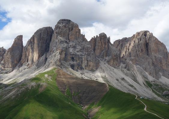
20 - ALPI BREONIE DI LEVANTE
Highest summit: Croda Alta 3289m
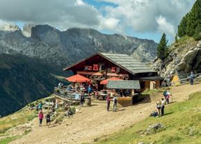
This small mountain chain, which runs from south-west towards north-east, isolated between the upper Isarco valley, Brennero and val di Vizze, is simply a small strip which runs in Italian territory, which is part of the larger Austrian Zillertaler Alps. They are wild and isolated mountains, where the charming and beautiful rifugio Europa or rifugio Venna alla Gerla, are the only back up point in this unknown and extraordinary chain.
Spina del Lupo, Gerla, Croda Alta, Olperer, romantic names for beautiful and prestigious mountains, immersed in an environment which is still natural and untouched.

All you have to do is follow the long and isolated val di Vizze, scattered with small villages and farm houses, discovering a high mountain environment of rare and unique beauty, where in the background, tall and unique the Gran Pilastro rises. The ascent to Gerla, to Croda Alta and Schrammacher are first class excursions and highly satisfying. Here we find the splendid rocky pyramid of Olperer, which after Grossglockner is the most appreciated mountain by the Austrians.
BOUNDARIES
• To the NORTH, the state border, from the Brenner Pass to Passo di Vizze
• To the EAST, Val di Vizze, from Passo di Vizze to Vipiteno
• To the SOUTH, the Vipiteno basin
• To the WEST, Valle dell’Isarco, from Vipiteno to the Brenner Pass
Schrammacher 3410mAlto Adige
18
Stampflkees and Schrammacher (© Fabrizio Rattin) Ô
20 ALPI BREONIE DI LEVANTE
TUXER ALPEN
Olperer
Fussstein
Schrammacher
STUBAIER ALPEN
Passo del Brennero
4 BREONIE DI PONENTE
Valle Isarco
ZILLERTALER ALPEN
La Gerla
rif. Venna alla Gerla
Sagwand
Croda Alta
Vipiteno
Cima Vallaccia
Punta del Tasso
Cima Rolle
Cima Gallina
Punta Bianca
Punta del Lago Romito
Passo di Vizze
Spina del Lupo )( )
ValleIsarco
Valle di Vizze
23 MONTI DI FUNDRES
(
19
5 GRUPPO DEI SARENTINI
GROUP’S GEOGRAPHY: the Alpi Breonie are the mountain chain which sets off from the Brenner pass. Towards west the Breonie di Ponente open up while to the east the Breonie di Levante stretch out. Breonie di Ponente are part of the vast Austrian group of the Stubaier Alps, while the Levante Breonie are part of the extended Zillertaler Alpen, or depending on other classifications the Tuxer Alpen.
The main chain of Breonie di Levante, as a frontier ridge, runs from the Brenner pass to passo di Vizze, and along this we find the more important reliefs such as Spina del Lupo and Croda Alta. From Spina del Lupo a modest mountain chain extends to the south and ends with cima Punta Bianca, above Vipiteno. While from Croda Alta, towards north, the main peaks of Schrammacher and Olperer run along into Austrian territory.
 Fusstein 3380m
20
SUBGROUPS AND PEAKS
• MAIN CHAIN: between the Brenner pass and Passo di Vizze
Highest summit: Croda Alta

Main peaks: Spina del Lupo, Punta del lago Romito, La Gerla, Croda Alta
Austrian sector: Schrammacher, Olperer
TOUR
1. Croda Alta
2. Schrammaker
Olperer 3476m
The majestic peaks of Fusstein and Olperer (© Fabrizio Rattin) Ô
21
Breonie di Levante (Zillertaler Alps)
HOHE WAND – Croda Alta 3289m
Normal Route from the East face
EAST, SOUTH - EAST snow fields and scrambling
An imposing summit which overlooks the entire Val di Vizze. Towards northeast it is connected to the beautiful Schrammacher along a long rocky ridge which is shaped like an amphitheatre over Stampflkees; towards South, instead, a rocky ridge joins it up to Grawand and then to Forcella Nevosa. Its western face is characterized by the continuation of the border’s ridge along secondary peaks up to Pfitsch Scharte.
An imposing peak which lies between Italy and Austria, very panoramic and highly satisfactory. Its east face is very tiring and the difficulty can vary depending on snow cover.
Type of itinerary: hiking to the snow field, then easy alpinism on a rocky slope covered in snow.
Gear: ice axe and crampons for the final slopes
Average excursion time: 5 hours from the car park to the summit
Recommended period: June- September
Difficulties: PD, 40° on snow, 1st grade on rock
Starting point: park along the road which runs up to Passo di Vizze at the fourth hair pin bend, at 1806m
Access: drive up along Val di Vizze until the last town of Stein where you take the evident dirt road which heads towards Passo di Vizze.
Follow it until the large car park situated just before the fourth hair pin bend where it is no longer allowed to continue with motorized vehicles.
Ascent: from the fourth hair pin bend along the Passo di Vizze road turn left onto path nr.4 and follow it to the Pass. Directly from the state border follow path 4b with signs for Schneescharte-Forcella Nevosa. Follow it along the wide panoramic ridge which runs between the boundary stones which lie between Italy and Austria until the track branches off to the right and follows the cairns standing along loose rocks and scree until you reach the glacier near the beautiful lakes of Forcella Nevosa. Set foot on Stampflkees, keeping on the left side until, always on the left, you notice an easy rampsnowy gully ascending to the right which gives access to the east face. Climb up the slope following the logical succession of snow and rocks aiming for the summit cross which is always visible above. Once you reach the ridge’s line follow it easily until the enormous summit cross.
Descent: back down the route taken uphill.
Cartography: Tabacco 037-Monti di Fundres-Gran Pilastro
8-10 h 1430m PD /40°/I 01 exposure back up points average excursion time type of itinerary vertical height gain difficulties
Rifugio Passo di Vizze 2275m
22
2634 Hohe Kirche
2943 Hohe Warte
3227 Sagwandspitze
Stampfkeers
Schrammacher 3410
Oberschrammachkeers
3143
Ameiskopft 2553
Aschafenferner
Hohe Wand
Croda Alta 3289
Pfitschscharte
Wasserfalköpfe 2575
Grawand 2987
Schneescharte
2835 Grawandkofel
Kellerkopf 2648
Zamserbach
Zinnen 2567
Urbanscharte 2835
Durregg 2272
Biotop Putzerbödenmöser
Sameregg 2134
LongseeLago lungo del passo
Pfitscher Joch-Hause - Rif. Passo di Vizze 2676

Pfitscher JochPasso di Vizze 2651
JochseeLago del passo
Jochplatte 2100
LS/SS508
Bichl
PfitscherBach - Rio di Vizze
S t a m p f l k e e s

01 Alpi Breonie di Levante > Croda Alta 24

 Schneescharte 2789m Forcella Nevosa
Hohe Wand 3289m Croda Alta
Nord Gipfel 3281m
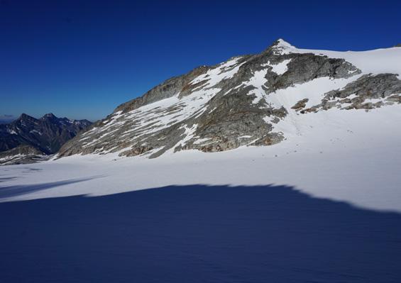
Gran Pilastro and Hochferner from the vicinity of Forcella Nevosa (© Fabrizio Rattin) Ô
Ascent track (© Fabrizio Rattin) Ó
Schneescharte 2789m Forcella Nevosa
Hohe Wand 3289m Croda Alta
Nord Gipfel 3281m
Gran Pilastro and Hochferner from the vicinity of Forcella Nevosa (© Fabrizio Rattin) Ô
Ascent track (© Fabrizio Rattin) Ó
25
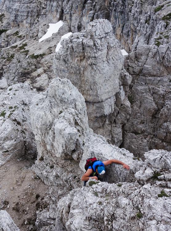
The strenuous uphill terrain (© Fabrizio Rattin)
to the ridge between Piz Lavarella and its southern foresummit. From its ridge, without any difficulties, you can easily reach the summit crosses. Beautiful views towards the entire eastern Dolomites.


Descent: Back down the route taken uphill.
Cartography: Tabacco 07 Alta Badia.
26
Piz Lavarella 3050m Piz de Lavarela
Piz Lavarella Ovest 3034m Lavarela de Fora
Ascent route (© Diego Filippi) Ô
Braies Piz
Gruppo Fanes Senes
lavarela
158
Piz Lavarella 3050m
159
Piz de Lavarela
Fanes Senes Braies Group, Tofana Group
TOFANA DI ROCES 3225m
From the via ferrata Giovanni Lipella and loop itinerary
path and ferrata WEST
8 h 1200m
Elegant rocky pyramid, isolated between Forcella Col dei Bos to the east and Forcella Fontananegra to the west.
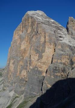
It is not the highest of the three Tofana peaks, but Tofana di Roces is certainly the most prominent and massive. Elegant in its shape, it reaches towards the sky, towards south it has a colossal wall, famous for the many popular climbing routes. On this famous dolomite peak the Lipella ferrata is unmissable: long and difficult. This itinerary is varied and exciting. It begins along the ancient war tunnel named “del Castelletto” thanks to this it pops out onto the western side. Proceed and making the most of the mountain’s lines such as ledges, chimneys and rock faces it comes out onto the northern ridge and along this to the far away summit. Considering even its descent, which is tackled on exposed terrain the itinerary is very difficult but highly satisfactory.
Type of itinerary:the paths are always well sign posted and the via ferrata is in good conditions.
Gear: normal hiking gear, a flash light for the tunnel, complete ferrata.
Average excursion time: 4-5 hours from the car park to the summit.
Recommended period: July, August.
Difficulties: EEA via ferrata of average difficulty but very long.
Starting point: rifugio Dibona 2037m.
Access by road: from Cortina d’Ampezzo climb up towards passo Falzarego, after approximately 5km you will find the junction for rifugio Dibona on the right. Follow the road until the large car park near the rifugio.
Salita: from the car park take the road, sign nr.403, for rifugio Giussani. Shortly after follow path nr.404 to the left with evident signs for ferrata Lipella. Passing by the base of Tofana’s entire south face you reach (in roughly one hour of walking from the car park) the start of the via ferrata. The itinerary begins straight away by entering the striking and very long war tunnel, a flash light can be useful, to then pop out onto some hanging ledges, right on the western face. Now the itinerary with a very logical line, makes the most of the many ledges, couloirs and short rock faces and gains height, head towards Punta delle Tre Dita, where it is possible to interrupt the ferrata by coming out onto the left and intercepting a path which leads to rifugio Giussani. Evident signs indicate these possibilities. Staying on Lipella, a long ledge on the right leads back onto the west face and to the base of the vast amphitheatre, usually covered by water streaks and snow at the beginning of the season. Continue along the equipment and with
EEA 27 exposure back up points average excursion time type of itinerary vertical height gain difficulties
160
rifugio Giussani 2580m
162
Descent: from the summit head back down the route taken up until the exit of the ferrata, where, turning right up steep screes and rocks, you go down to rifugio Giussani. From here along an easy path nr.403 head back to rifugio Dibona and the car park.

27
Tofana di Roces 3225m
Start of the Lipella via ferrata (© Diego Filippi)
The south face of Tofana di Roces (© Diego Filippi) Ó
A panoramic view of Tofana (© Diego Filippi) Ô Senes Braies Group > Tofana di Roces
Fanes
a last bit of effort, finally you pop out onto the northern ridge of Tofana di Roces. Along this, along an evident path without any difficulties, reach the summit cross. Breath taking views all around and towards the surrounding dolomite peaks.
Cartography: Tabacco 03 Cortina d’Ampezzo.

163
TOUR
36. Dente del Sassolungo
37. Sassopiatto
38. Piz Boè
39. Le Mesules
Torre Innerkofler 3098m
Punta Grohmann 3126m
Sassolungo 3181m
Punta Cinque Dita 2999m
Spallone del Sassolungo 3081m


Sassolungo Group (© Diego Filippi) Ó
Sassolungo Group (© Diego Filippi) Ô
Dente del Sassolungo 3001m
Punta Grohmann 3126m
Torre Innerkofler 3098m
212
 Dente del Sassolungo 3001m
Torre Innerkofler 3098m
Punta Grohmann 3126m
Punta Cinque Dita 2999m
Sassolungo 3181m
Spallone del Sassolungo 3081m
Sass Pordoi 2950m
Sassolungo Group (© Diego Filippi) Ó
Dente del Sassolungo 3001m
Torre Innerkofler 3098m
Punta Grohmann 3126m
Punta Cinque Dita 2999m
Sassolungo 3181m
Spallone del Sassolungo 3081m
Sass Pordoi 2950m
Sassolungo Group (© Diego Filippi) Ó
213
Sella Group (© Diego Filippi) Ô

Piz Miara 2964m Piz Selva 2940m
Piz Ciavazes 2828m
214
Sella Group (© Diego Filippi)
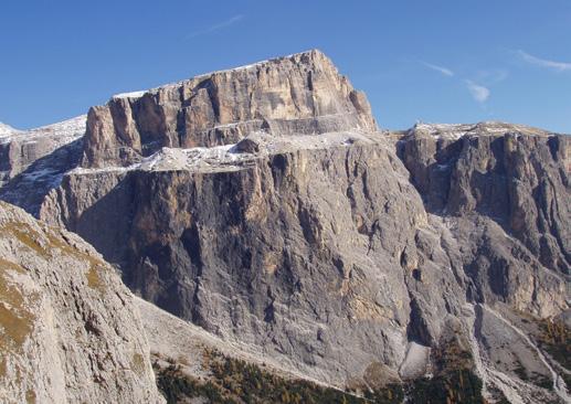
Piz Boè 3152m
Sass Pordoi 2950m
215
L’Antersass 2908m
DENTE DEL SASSOLUNGO 3001m
Along the Normal route
SOUTH AND WEST
path and climbing route
Prominent rocky tower, wedged in between Sassopiatto and Torre Innerkofler. Distinctly separated by these two across the deep carved out sections of the Forcella Orientale del Sassopiatto and Forcella del Dente.
No better name suits this spectacular rocky tower, with its square shaped flanks and its yellow vertical rock faces, which drop down for over 300 metres above the green meadows of Pian de Sas. The normal ascent route roughly follows the western arête, with average difficulties of II and III grade, with a few moves of IV. The rock is usually good and there are enough protections on the wall. This ascent, even if easy, requires a minimum amount of classic climbing experience in the Dolomites. The southern access to the Sassopiatto’s eastern saddle where the beginning of the climbing route begins, requires a lot of care due to the loose rock underfoot. In case of any snow at the beginning of the season crampons will be necessary. All in all it is a complete ascent: a laborious access, a climbing route without much protection and a descent which requires abseiling which is not at all simple.
Type of itinerary: paths are well sign posted, hardly any tracks and climbing route with hardly any protection.
Gear: normal trad climbing gear, a few cams, kevlar threads to leave in situ, crampons at the beginning of the season.
Average excursion time: 4.30-5 hours from the car park to the summit.
Recommended period: June- October.
Difficulties: PD+, climbing route with sections up to III+, IV.
Starting point: Passo Sella, Rifugio Valentini 2218m, pay and display car park.
Access by road: from Val Gardena or from Val di Fassa reach Passo Sella and follow signs for Rifugio Valentini (dirt road uphill), park in the small pay and display areas.
Ascent: From the car park near Rifugio Valentini take the dirt road which goes past rifugio Salei and leads to Forcella di Rodella (2308m). Before reaching the saddle, leave the dirt road to climb up to the right, along the ski slopes aiming towards the highest of the chairlift top stations. One track allows to reach the ridge, grassy in sections and covered in dirt. Climb up the ridge to the end, level with Punta Grohmann (SouthEast arête) and shortly before reaching the rocks traverse to the left (west) along an evident track. Walk around Punta Grohmann and the successive Torre Innerkofler until you reach the base of Dente del Sassolungo. Go past its yellow south face until you reach the entrance of a narrow rocky gully; climb up it and enter the gully which heads up towards Forcella Orientale del Sassopiatto. Continue
8-9 h 800m PD+/III/IV 36 exposure back up points average excursion time type of itinerary vertical height gain difficulties
rifugio Sandro Pertini 2284m 216
Sella-Sassolungo Group, Sassolungo Group
Ciampanil Comici 2799
3093 Wessely turm
3181 LangkofelSassolungo
HocheggePiza da Uridl 2102 Ponjin 2382
Plattkofeltürme - Torri del Sasso Piatto
2688
PlattkofelhütteRif. Sasso Piatto
Lari
LangkofelhütteRif. VicenzaPertini
Langkofelkarspitze - Punta Dantersasc 2820

Fünffungerscharte - Forc. Cinque Dita
ZahnköfelIl dente 3001
Rif. Sandro Pertini
Langkofeleck - Spallone del Sassolungo 3081
GrohmannspitzePunta Grohmann 3126
Gabia
Rif. Friedrich August
Forc.la Rodera
Col Rodela 2484
Rif. Col Rodela
SS48
Rif. Salei
Passo Sella
SS242 Rif. Des Alpes
Rif. Valentini
Rif. Micheluzzi Rifugio DonaCiaslat c
PlattkofelSasso Piatto 2969
Average excursion time: 4-5 hours from the car park to the summit.
Recommended period: June-October.
Difficulties: AD II,III, 2 sections of IV.
Starting point: parking above Malga Civertaghe 1442m.
Access by road: from Fiera di Primiero head up towards San Martino di Castrozza and once past Valmesta you reach the first large hair pin bend where you leave the main path. Follow the asphalt road following signs for Malga Civertaghe. Once you reach it continue on the flat following signs for Rifugio Velo della Madonna and after a hair pin bend you reach the large car park where it is forbidden to continue.
Ascent: from the car park take path nr.713 directly reaching Rifugio del Velo; go past it towards Forcella della Stanga, stopping where the evident gully comes down from Sass Maor and Cima della

Madonna with evident wedged in boulder where you start near a rockface. Start up the wall directly passing just to the left of the wedged in boulder (difficult section) until you set up anchor inside the gully (IV/A0). Faithfully follow the deep gully going around the wedged in boulders until the saddle which divides Sass Maòr from Cima della Madonna (II-III). Continue up the north side up nice walls until the buttress which looks over Val Canali (150m II-III). Go round the summit tower on the east side along the easy ramp which leads under the vertical chimney. Climb up the chimney traversing to the left to then find an anchor point (IV), continuing straight up along a corner-gully (III-II) you pop out onto the beautiful summit.
Descent: back down the uphill route using the anchor points used during the ascent. Under the saddle between Sass Maor and Cima della Madonna watch out and follow the first gully on the right and then the one on the left, especially with scarce visibility.
74
Pale di San Martino > Sass
Just below the saddle between Sass Maòr and Cima della Madonna (© Franz Pompoli) Ô
Maor
Cartography: Tabacco 022 Pale di San Martino.
396
Ascent Sass Maor (© Fabrizio Rattin)

Sass Maor 2812m
Cima della Madonna 2752m
397
Rifugio del Velo 2358m
CIMA DELLA STANGA 2550m
Along the Dino Buzzati via ferrata and descent from the equipped ‘Sentiero del Cacciatore’
vie ferrata and scrambling
Cimerlo shuts off the San Martino chain to the south, overlooking the entire valley of Primiero. Cima della Stanga to the north connects it to the rest of the mountain chain.
With this beautiful loop itinerary, as well as touching two splendid summits, you cover valleys of extraordinary beauty typical of the Dolomites. The uphill route follows the Dino Buzzati via ferrata, which varied and steep, runs along a labyrinth of towers and pinnacles along the lower part. On the upper part it follows the wall’s logic: long ledges and chimneys. Downhill you follow the spectacular and wild ‘Sentiero del Cacciatore’, party equipped with metal cables. From the peak the view is remarkable over the east face of Sass Maòr and over the entire Val Pradidali.
Type of itinerary: well sign posted path but steep and uneven, via ferrata, easy scrambling to reach the summit.
Gear: normal hiking gear with complete ferrata set.
Average excursion time: 3.30-4 hours from the car park to cima della Stanga.
Recommended period: June-October.
Difficulties: EEA, via ferrata of average difficulty.
Starting point: parking just before the Fosne meadows, in Val Canali, 1326m.
Access by road: follow the entire Val Canali to the Restuarant La Ritonda where, on the left you follow an asphalt road uphill until the evident car park with Cai sign posts.
Ascent: from the car park shortly to the left reach the beautiful Fosne meadows where you take path nr.731 to the right, then follow a dirt road until the meadows of Rodèna and then horizontally to the right along path nr.747 until an evident scree. Climb up steeply to the left through the woods which become scarcer, until the base of the first rocks, where a surreal labyrinth journey among the towers of Cimerlo begins. Climb up the steep sections until the start of the via ferrata Dino Buzzati. Carefully follow the nice equipped sections and after a steep ladder, pop out with amazement onto a large hanging meadow in among the tall rock faces. Continue along the path until you reach a saddle not far from the summit where you leave path nr.747 for an exposed ridge towards south-west, which with a few easy sections of first grade leads to the foresummit. Carefully reach the top without great difficulty, and ignore the junction on the right (Sentiero del Cacciatore) and reach the nearby cima della Stanga.
Descent: from cima della Stanga return back along the route taken uphill, until the junction
7-8 h 1250m EEA 75 exposure back up points average excursion time type of itinerary vertical height gain difficulties
SOUTH-EAST CIMERLO 2503m
Pale di San Martino, Central Massif 398
none
Rifugio Forestale

Cima di Val di Roda
2791
Cima delle Scarpe 2731
Ghiacciaio di Pola
Pala di San Martino 2982
Cima Immink 2862
2731 Cima Pralidali
Passo di Bali
2774
Torre Pralidali Campanile Pradidali
Passo delle Lede
Cima Wilma
2774
Ghiacciaio della Fradusta Superiore
2939 Cima La Fradusta
SS50
Rif. Forestale delle Laste
a V e c c h i a P rati Ronz
2550 Sas del Cogol
Rifugio Petina
2744
2802
Cima di Bali
Forcella Stephen Forcella Porton
Cima Canali 2859
Sass Maòr
2812
Cima della Stanga
2550
2503 Cimerlo
SA N MA RTIN O D I C A S T ROZZ A
TorrenteCanali
orrent e C i smon V
l P r a d i d a l i V a l P a t a n e V al dell
Prati Ronz V a l M a l e B o s c o C i m e r l o
i v e r t a g h e
o n t e P r a t o C i m e r l o V a l C i s m o n
T
a
Z
Pedem
Gear: normal hiking gear, with lightweight harness and 40 metre rope.
Average excursion time: 3-3.30 hours from the car park to monte Neva.
Recommended period: June- October.
Difficulties: EE/F+ rock sections, easy but exposed. A 20m abseil.
Starting point: Rifugio Fonteghi 1100m.
Access by road: from the town of Imèr in Valle di Primiero follow signs on the right for Val Noana and along a narrow asphalt road you reach Rifugio Fonteghi.
Ascent: directly from Rifugio Fonteghi turn left along path nr. 748, which with a steep dirt road leads to Casera Scaorin 1553m. Continue along the evident tracks, now path, along a panoramic wooded ridge. Traverse for a long section below

the cima degli Spizoti until you reach a saddle with view over val Giasinozza. Here leave the main path and following the evident ridge towards west shortly reach the panoramic meadowy summit of Spizoti. Once back on path nr.748, follow it faithfully until the nearby peak of Col di San Piero. Leave path nr.748 and keep following the ridge aiming towards north-east, finding a first passage through mountain pine which then quickly leaves space to a rocky slope with scree. Follow the many cairns and some old yellow-orange signs until you reach a wide foresummit which after a short ascent, leads to the beautiful crux of Monte di Neva: a summit with wonderful views all around. This is where the hiking section ends. Head down towards north east along the ridge, ignoring an evident section of mountain pine which turns towards south.
Go down towards north aiming towards the evident saddle with the southern tower “Torre Meridionale” and reach it carefully along the section with difficulties of up to second grade.
84
Monte Neva 2228m
Alpi Feltrine Group > Monte Neva
The ascent route to Monte Neva from Colle di San Piero (© Diego Filippi) Ô
440

 Col di San Piero 1954m
Spizoti 1911m
Monte Neva 2228m
Torre di Neva Meridionale 2240m
Spizoti and Col di San Piero (© Diego Filippi) Ó
Col di San Piero 1954m
Spizoti 1911m
Monte Neva 2228m
Torre di Neva Meridionale 2240m
Spizoti and Col di San Piero (© Diego Filippi) Ó
441
Nice view over Torre Meridionale and Monte Neva (© Diego Filippi) Ô
Watch out not to miss the cairns and the rare signs, after a short section dropping down, traverse along an easy rock section and take a system of easy ascending ledges to the left until you face over the drop towards Torre Centrale. Here you turn sharply to the right along a ledge, climb up the chimney and with easy rocks you reach the solitary summit of Torre di Neva Meridionale. Cairn. Continue lowering down easily towards north east until the saddle with screes which separates the southern tower ‘Torre Meridionale’ from the central tower “Centrale torre” and climb up easy rocks at the top of this last one, fully enjoying the rare feeling of beauty and isolation of these forgotten elevations.

Descent: continue traversing towards north east slightly downhill with easy sections of first grade and reach an evident saddle, where a difficult ridge branches off towards the wild Torre Settentrionale. Turn towards south following a yellow coloured arrow and follow a busy track with signs and cairns towards Cadìn di Neva. Shortly you reach a large rock spike with kevlar threads, from where you abseil down with a 20m rope in a chimney (III). Continue downhill carefully towards south until an evident carved out section which gives access to a long descending rampledge towards south-west, which completely traverses the south face of Torre Centrale. Follow the ramp, with different sections of first and second grade which are not exposed, until you reach the striking basin of Cadìn di Neva and the easy path which crosses it. Continue downhill along the nice track until you reach Malga Neva and aim towards east to the bottom of the valley until you find an evident path which climbs up to Rifugio B. Boz 1718m. After eating and drinking take path nr.727 and keeping to the orographic left or right as you please, reach “El Belo” at the bottom of Val Noana. Following the asphalt road for a couple of kilometres you return to Rifugio Fonteghi, ending this very satisfying loop.
Cartography: Tabacco 023 Alpi Feltrine, Le Vette, Cimonega.
84 Alpi Feltrine > Monte Neva
442
Descent from Monte Neva (© Diego Filippi)
443

rockexperience.it share your experience #rockexperience #myrockexperience tag your experience @rockexperienceofficial THINK ECOLOGY, WEAR ROCK TECHNOLOGY.