Discover Germany | Special Theme | Bern City Special
Unspoilt nature at its best Searching for an exceptionally beautiful and diverse landscape? Why not head to the Regional Nature Park Gantrisch? Here, one can slip in their hiking shoes and explore the Gantrisch panoramic trail – a beautiful pre-alpine altitude hike with numerous lookout points and scenic, as well as cultural highlights. TEXT: NANE STEINHOFF
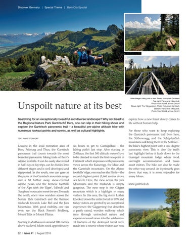
Located in the local recreation area of Bern, Fribourg and Thun, the Gantrisch panoramic trail counts towards the most beautiful panoramic hiking trails of Bern’s Alpine foothills. It can be easily discovered in half-day or day trips, can be divided into different stages and is well developed and signposted. In the south, one can gaze at the peaks of the Gantrisch mountain range and a bit further away, snow-covered Alpine peaks and the Bernese foothills of the Alps with the ‘Eiger’, ‘Mönch’ and ‘Jungfrau’ mountains meet the eye. Towards the north, one’s view wanders across the Nature Park Gantrisch and the Bernese midlands towards Lake Biel and the Jura Mountains. With good visibility, one can even see the Black Forest’s Feldberg, Mount Titlis or Mount Pilatus. Starting in Zollhaus on around 900 metres above sea level, hikers need approximately 32 | Issue 41 | August 2016
six hours to get to Gurnigelbad – the hiking path’s last stop. After starting in Zollhaus, the first 500 altitude metres have to be climbed to reach the first viewpoint in Hällstedt which impresses with panoramic views across the Kaiseregg, the Märe and the Gantrisch mountains. On the Alpine foothills’ ridge, one reaches the Pfyffe – the second-highest point (1,666 metres above sea level). Here, the view across the Jura Mountains and the midlands is simply gorgeous. The next stop is the Gägger mountain which is a highlight to many visitors. In this area, the big storm Lothar knocked down the entire forest in 1999 and today visitors are greeted by an exceptional experience: the ‘Gäggersteg’ that describes a partly raised, wooden walkway which runs through untouched nature and exposes unusual views into the wilderness. 12 hectares of the destroyed forest were made into a reserve where visitors can now
Main image: Hiking with a view. Photo: Naturpark Gantrisch Top right: Panoramic hiking trail. Photo: Max Stöckli, artmax GmbH Above right: The ‘Gäggersteg’. Photo: Naturpark Gantrisch Bottom: Panoramic hiking trail. Photo: Max Stöckli, artmax GmbH
explore how a new forest slowly comes to life without human help. For those who want to keep exploring the Gantrisch panoramic trail from here, the Süftenenegg and the Schüpfenfluh mountains will bring them to the Selibüel – the hike’s highest point with a 360-degree panoramic view. This is also the trail’s last highlight before it leads down to the Gurnigel mountain lodge where food, overnight accommodation and buses await visitors. The hike can also be made the other way around. As it primarily goes down that way, it is more enjoyable for many hikers. www.gantrisch.ch