
www.boulia.qld.gov.au BOULIA SHIRE BOULIA + URANDANGI


CONTENTS4 Boulia 5 Min Min Light 6 Boulia Heritage Centre 8 Urandangi 9 Tourist Itineraries 10 Regional Map 11 Shire Snap Shot / Directory 12 Events Calendar Boulia Shire Council respectfully acknowledges the Traditional Custodians – Pitta Pitta People, Bulamu Waluwarra and Wangkayujuru People, Kalkadoon People, Wangkamahdla Nation, Yulluna People – of the land which lies within the boundaries of the Boulia Shire. We also recognise the Elders both past and present and the ongoing effort to protect and preserve Aboriginal and Torres Strait Islander cultures within the Boulia Shire. ACKNOWLEDGEMENT TO COUNTRY Boulia Shire Council would like to acknowledge the tireless efforts of photographers Jan Norton, Ann Britton, Jack Neilson, Rob Mulally on behalf of Outback Highway Development Council and Peter Coates, whose expertise contributed to this brochure. 2 www.boulia.qld.gov.au CONTACT US Boulia Shire Council Call (07) 4746 3188 | Visit: Herbert Street, Boulia www.boulia.qld.gov.au /BouliaCouncil

Both towns were a rest stop and watering hole for travellers, Cobb and Co, goods carriers and drovers.
Finally the humble beginnings of the Boulia and Urandangi settlements were forged in the late 1800’s.
WELCOME TO THE BOULIA SHIRE The Boulia Shireis built on a rich and interesting history DID YOU KNOW? The average rainfall for the Boulia Shire is 271mm per annum. The average summer temperature is 40 degrees Celsius. www.boulia.qld.gov.au 3
One thing is for sure, you are going to want your camera on hand when you explore the rich tapestry of the Boulia Shire. Welcome to our shire, Capital of The Channel Country and Land of the Min Min Light and the place that we call home.
Encompassing a 62,000 square kilometre land mass of predominately Mitchell and Flinders grass plains, the Boulia Shire is considered to be exceptional fattening country for livestock. Beneath the surface is a wealth of natural treasures including gas, oil and diamonds – and these are only the deposits that we know of.
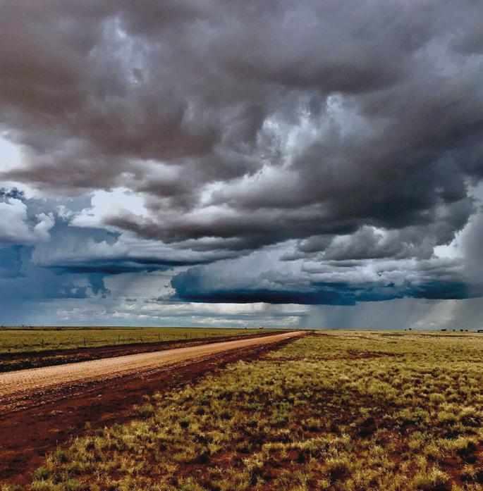
Steadfast throughout time has been the majestic landscape of the Boulia Shire. Tree-less open plains, hundreds of meandering channels and night skies full of glorious stars that you feel you could almost touch.
The town’s businesses also provided services for an ever emerging grazing industry. For many years the Boulia Shire ‘rode on the sheep’s back’.
Steeped in a rich history which evolved 100 million years ago when the shire was part of the Inland Sea and was home to a mass of marine reptiles. It was the meeting grounds for many Indigenous tribes who were assured of permanent water. The famous explorers Burke and Wills made a camp on the southern side of Boulia and on parts of their journey followed the Burke and Wills rivers, as they are known today. There are still traces of marker pegs where Afghan camel traders used to travel through the shire.


MinmysteriousBoulia’sMinLight
It is the Land of the Min Min Light, Capital of the Channel Country and big sky country. Boulia encapsulates these well earned titles and so much more. This bustling outback town’s origins date back to 1876 when the first inkling of a township was nurtured by storekeeper James Edward Jones. Then in 1879, 1280 acres of land was gazetted and set aside for the development of a town. It was up and onwards from here with the first home being built in 1888. At different phases of its past, Boulia was home to three hotels, the Bank of NSW (Westpac Bank), two grocery shops and a clothing store. Trans Australian Airlines (TAA) used to land their DC3 at the Boulia airport once a week en route to Brisbane. These days Boulia still boasts a regular regional airline service, general store and hardware store, roadhouse and much more.
BOULIA
As our town has progressed over many generations, what has stood the test of time over hundreds of years are the famed Min Min Lights. There is no rhyme or reason as to what the lights are, when and where they will appear and how long they will appear for. There are many myths and bush yarns about the lights, which are still seen today.
The name Boulia was chosen for its Indigenous significance to the area. It is believed the name derives from a waterhole in the Burke River named Bulla Bulla.
4 www.boulia.qld.gov.au
A TOWN WITH MANY FEATHERS IN ITS CAP
BOULIA TO WINTON – 362km MOUNT ISA – 304km BEDOURIE – 192km ALICE SPRINGS – 821km
DID YOU KNOW?


MIN MIN LIGHT
MIN MIN ENCOUNTER The Boulia Shire’s most prized attraction is the Min Min Encounter. It’s a guarantee that once you venture through the doors of the 45-minute animatronics show, you will never forget your experience. It is like no other.
Gordon was a well-known lad in the Boulia Shire. He was one of seven kids from a pioneering family who had a station in the south-eastern tip of the shire. It was around 70 years ago now that Gordon had one of his first encounters with the mysterious ball of light they call the Min Min. With a handful of men, Gordon had headed out onto the Boulia to Winton Road to fix a bore. The mill was a few kilometres in off the main road. Gordon and one of the men had decided to walk out to the road and wait for the mail truck, which they knew would be coming past on its weekly run. After a few yarns and jokes were told, a light finally appeared in the distance. The two waited.... and waited.....and waited for the light to get closer. No sign of the truck. Then the light disappeared from view. A little spooked by the vanishing light, Gordon and his co-worker headed back to the camp. Suddenly the light appeared in front of the men, and they knew it was a Min Min Light. The mysterious light ‘played’ with the two for a while and then disappeared, not returning again that night. Gordon described to his family how the hair on his arms and neck ‘stood up’ with fear from his encounter. He had said there was no sound whatsoever when the light appeared. During his lifetime Gordon had many encounters with the Min Min Lights and had always said they gave him an uneasy feeling – perhaps it’s the unknown. Thank you to Cindy Nicols for allowing us to use her late father Gordon Robinson’s Min Min Light experience in this brochure. The Min Min Lights have been a part of life in Boulia for hundreds of years. It is described as a glowing ball of light about the size of a football. The light most commonly appears to be around eye level or slightly higher. It can also be seen dancing and darting as it’s moving. There are even reports of the one light dividing into two. Despite many experts attempting to solve the mystery of the light’s origin, to date no one has been successful.
DID YOU KNOW?
The first recorded sighting of the Min Min Light was in July in the early 1900’s at the sight of the old Min Min Hotel on the road to Winton. www.boulia.qld.gov.au 5
The lights are still seen today, however, legend says they pick their own time to appear and who to appear too. You don’t go looking for the Min Min, the Min Min goes looking for you and anyone who does see it never forgets it.
The show also reveals some of the many explanations as to what the mysterious lights may actually be.
Show creators have brought many bush characters to life and what makes this display so very unique, is the opportunity to meet them in their own environment and listen to the stories about their light sightings. Without giving too much away, look out for the lifesize truck or the station veranda after you’ve walked through the hotel bar.
The Boulia Shire Council own and run the centre, which offers visitors the opportunity to talk to the friendly staff. Make sure you call in and make the most of the first hand knowledge of other things to see and do in Boulia and neighbouring shires as well as access to up-to-date road conditions. The Min Min Encounter and Information Centre also has a souvenir shop.

Our first human inhabitants were the Indigenous peoples. Look for the display in Howards Cottage within the walls of the centre. This gives an insight into the life of the Indigenous residents of the Boulia Shire by way of photos and artefacts.
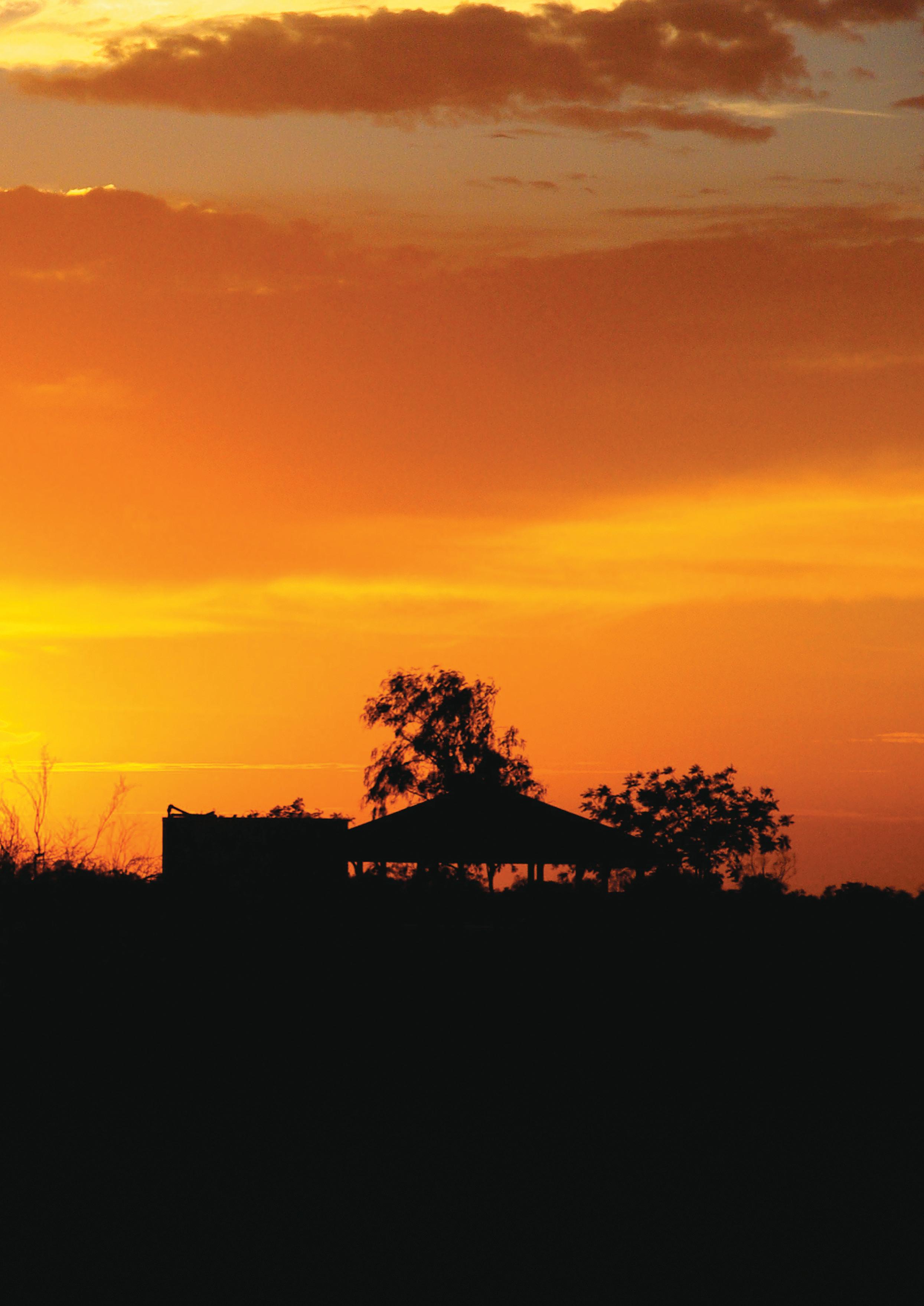
PHOTOGRAPHY Boulia at sunrise or sunset is a photographer’s dream. Capture the rich reds, yellows, oranges and pinks which stream across the skyline every morning and evening without fail.
Showcasing Boulia’s three distinct phases of evolution, the Boulia Heritage Centre takes visitors on a journey back through time.
The first solid structural home in Boulia built by storekeeper James Edward Jones sits proudly at the front of the heritage centre. Built in 1888, the stone house has stood the test of time and a visit to this Heritage-listed former home is like stepping back in time. Each of the rooms has been filled with furniture and other items dating back more than 100 years. Look out for the hexafoil symbol which is believed to have been carved into a shutter to guard the house occupants from evil spirits.
You will find the Red Stump on the town’s main median strip which is Boulia’s answer to the Black Stump.
EARLY SETTLERS
Last but not least are the many displays of life in Boulia throughout the last 139 years, with displays dedicated to the hospital, the school and life on outback stations.
OTHER THINGS TO DO AROUND TOWN
CENTREHERITAGE
BOULIA
WINDMILL AND WATER TANK
For those visitors who prefer the company of the feathered kind, Boulia is a bird watcher’s paradise. From wedge tailed eagles to ring necked parrots and budgies.
RED STUMP
STONEHOUSE COTTAGE
CORROBOREE TREE
Noted as Australia’s best Ichthyosaur display by museum experts, our authentic fossils give you a firsthand insight into these prehistoric predators of the Onedeep.ofthe fossils on display is our Plesiosaur ‘Percy’, over 30 feet long and 85 per cent complete. He was one of the most fearsome marine reptiles in his day. Make sure you allow time to look at the intact jaws and teeth of an Ichthyosaur. Boulia’s marine reptile fossil display is also home to a previously undiscovered species of sea turtle. The Bouliachelys suteri was found by local brothers Dick and John Suter and this was named after the two self taught palaeontologists, who are sadly no longer with us. This exhibit truly is an outstanding collection of marine reptile fossils found locally and displayed in the Boulia Heritage Centre in collaboration with the Queensland Museum.
SPLASH PARK Don’t let age get in your way when it comes to a cool down. Stand under the water-filled mushroom or the water spraying turtles. This free Boulia attraction is worth its weight in gold after a long drive.
BIRDWATCHING
WORLD CLASS MARINE FOSSILS
SPORTS CENTRE Boasting a 25-metre shaded pool, basketball, squash and tennis courts and a state-of-the-art gymnasium, the multi-functional Boulia Sports and Aquatic Centre needs to be seen to be believed. The centre has seasonal operating hours, so check at the Min Min Encounter and Visitor Information Centre for opening times.
6 www.boulia.qld.gov.au
On the edge of the town is the windmill and water tank. Said to be one of the first windmills in Boulia which used to pump the town’s water supply, this is a unique structure as it is 30 feet tall. Alongside the windmill is the water tank with an impressive mural depicting the amazing landscape of the Boulia Shire. While you’re in the area check out the old wagon from yesteryear on your way past.
BOULIA’S FIRST PEOPLE
The last known Corroboree Tree of the traditional people of Boulia, the Pitta Pitta, is in easy walking distance from the main street.

POLICE BARRACKS
BOULIA CEMETERY
Discover the amazingmarine reptile fossil displayfound locally and housed in theBoulia Heritage Centre VENTURE A LITTLE FURTHER
If you’re looking for peace and tranquillity with a touch of nostalgia, head out to the Police Barracks, 25km north on the Selwyn Road. Between 1874 and 1884, Sub-Inspector Ernest Egglington was stationed at the waterhole with a handful of native mounted police. Some mounds of stone rubble which were the police barracks still remain at the site. A picnic area has been erected close by the waterhole along with a stone pitched BBQ.
Known for their exceptionally hard wood and longevity, the Waddi Tree, also known as Acacia peuce, is an extremely rare find. Boulia has two Waddi Tree sites. A small cluster approximately 20km south on the road to Bedourie or much larger clusters on the Coorabulka Road also to the south, about 10km. The Boulia clusters are referred to in the diaries of explorers Burke and Wills in the early 1860’s. The trees are a protected species and are found in only three locations in Australia – Boulia, Birdsville and another in a conservation reserve in the Northern Territory.
Minding the precious past of Boulia is the local cemetery. Situated high on the northern crest of town, allow yourself time to have a look at the pioneering history and the silent stories they tell.
GOLF COURSE Check out the 18 hole sand green course at the Boulia Golf Club. A hint – try and coincide your visit with one of their fun days – Pink Ribbon Golf Day plus Mothers and Fathers Day Ambrose. www.boulia.qld.gov.au
WADDI TREES (ACACIA PEUCE)
BENDGEACCA
7
One of the many channels of which the Boulia Shire is renowned for, Bendgeacca waterhole is definitely a local favourite. Situated about 10km north of Boulia on the Donohue Highway, Bendgeacca is the ideal location to have a relaxing day. Try your luck catching a yabby or yellow belly or just enjoying being in an outback oasis.


Urandangi was the ideal place for the drovers to stop as there was usually water in the Georgina River and if not, there was always the stock water trough. Urandangi became the drovers’ stop between Camooweal and Dajarra and quickly expanded into a township where mail and supplies could be accessed. It was not an uncommon sight to see at least three mobs of drovers with up to 2000 head of cattle on the stock route around Urandangi.
URANDANGI TO MOUNT ISA – 183km BOULIA –TOBERMOREYCAMOOWEAL307km–250km–98km
8 www.boulia.qld.gov.au
Also in Urandangi is the cemetery which has several Chinese graves. In the early part of the 1900’s, there were Chinese market gardeners living in Urandangi and growing an impressive array of fruit and vegies.
THE GREW AS NUMBERS OF DROVERS USING THE GEORGINA STOCK ROUTE GREW
Also a must before leaving Urandangi is a visit to the iconic Dangie Bush Resort (Urandangi Pub) for a well earned “coldie” and a chance to meet the locals.
If you are thinking of heading further north or west, contact the Min Min Encounter and Visitor Information Centre for up-to-date road conditions.
TOWNSHIP
Just some of Urandangi’’squirky signage
URANDANGI
When visiting Urandangi, head down to the Georgina River which runs near town. The tranquillity of the majestic river gives an insight into its past. You can see why it has had songs and poems written about it. Definitely worth throwing in a line if there is water in the river at the time of your visit.
In its heyday, the Dangi, as it’s commonly referred to, had three hotels, two stores and a post office. There was also a dance hall which was a welcome site for many a drover.

TOURIST ITINERARY
TOURIST ITINERARY
Follow the Outback Way as this is the most direct route from Laverton (WA) through to Winton (QLD). There is a combination of sealed and gravel road which skirts across the edge of the Simpson Desert.
604km – Harts Range is an Indigenous community set in the spectacular Harts Ranges. Amenities for travellers include a camping area with facilities. Groceries are available at the Harts Range store along with an ATM. 686km – Back on the bitumen and into Gemtree, a fully fledged tourist park. Here you will find cabin accommodation, camping and a shop. Gem fossicking and fuel is also 821kmavailable.–Youhave reached the heart of the red centre, Alice PleaseSprings.note: all designated stops on this stretch of the Outback Way have credit card and eftpos facilities and some offer emergency mechanical repairs.
2
BOULIA TO MOUNT ISA – 304KM / URANDANGI 307KM
BOULIA – ALICE SPRINGS
Travel on fully sealed roads from Boulia to Dajarra (150km), and then onto Mount Isa. Look out for the remnants of old railway line and road crew work pits from the 50’s. North of Dajarra are the turn offs for the South and North Urandangi roads (gravel). From Urandangi, travellers can venture across to the Outback Way, join with the Sandover Highway or take the back road to Camooweal.
3 TOURIST ITINERARIES www.boulia.qld.gov.au 9 NULLARBOR PLAIN Laverton GIBSON DESERT TANAMI DESERTMUSGRAVERANGES SIMPSONDESERT SIMPSONDESERT KANGAROO MOUNTAINS DESERTSTONYSTURT STRZELECKIDESERT DESERTTIRARI LakeNorthEyre GregoryLakeBlanche CallabonnaLake FromeLake YammaLakeYamma MoreaBilpaClaypan LakeTorrensEyreSouth HWY HWY HWY STRZELECKI WINTONJUNDAHROAD BIRDSVILLE OODNADATTA TRACK STUARTSTUART HWY TRACKTRACKSA NTWA QLD Tropic of Capricorn 23 26 30’’ SANDOVER GOLDFIELDS HWY Winton Cairns Via HughendenCANNING TANAMI TRACK Betoota Oodnadatta Alice Springs Gemtree (AyersUluru Rock) Innamincka Marree Hungerford Tibooburra Wanaaring Warburton LeonoraLeinster Yulara Cadney Park Marla William CreekCooberGinaPedy Kulgera Tobermorey Yuendumu Rabbit Flat Balgo Community AileronTiTreeBarrow Creek TennantWauchopeCreek Barklys HS R’House CamoowealMt Isa Dajarra Julia CreekCloncurryMcKinlay Urundangi Richmond Kynuna CorfieldStamford WindorahEromangaJundahStonehengeLeighCopleyBirdsvilleBedourieCreekRoxby DownsLyons BarlonO’MalleyCookHughes Deakin Tarcoola AndamookaLyndhurst Thargomindah Kilometres SEALED ROADS HIGHWAY i TANA y PERTH CAIRNS Perth Via Kalgoorlie Australia’s Longest Shortcut PERTH TO www.outbackway.org.auCAIRNSFordetailedinformationvisit World’s TreasureGeocacheLongestTrailHunt Pack your car and bring the kids. You can do it too. 303km-longest distance to fuel NULLARBOR PLAIN Laverton GIBSON DESERT TANAMI DESERTMUSGRAVERANGES SIMPSONDESERT SIMPSONDESERT KANGAROO MOUNTAINS DESERTSTONYSTURT STRZELECKIDESERT DESERTTIRARI Lake Eyre GregoryLakeLake Lake MoreaBilpaClaypan LakeTorrensLakeEyreSouth HWY HWY HWY STRZELECKI WINTONJUNDAHROAD BIRDSVILLE OODNADATTA TRACK STUARTSTUART HWY TRACKTRACKSA NTWA QLD Tropic of Capricorn 23 26 30’’ SANDOVERPLENTY GUNBARREL GUNBARREL GOLDFIELDS HWY HWYHEATHERHWY Winton Cairns Via HughendenCANNING TANAMI NAMATJIRA DRIVE TRACK HARTS RANGE Betoota Oodnadatta Alice Springs Gemtree Jervois (AyersUluru Rock) Innamincka Marree Hungerford Tibooburra Wanaaring Warburton LeonoraLeinster Yulara SpringsCurtin Cadney Park Marla William CreekCooberGinaPedy HermannsburgKulgeraMtEbenezer Tobermorey Erldunda YuendumuPapunya Rabbit Flat Balgo Community AileronTiTreeBarrow Creek TennantWauchopeCreek Barklys HS R’House CamoowealMt Isa Dajarra Julia CreekCloncurryMcKinlay Urundangi Middleton Richmond Kynuna CorfieldStamford Boulia WindorahEromangaJundahStonehengeLeighCopleyBirdsvilleBedourieCreekRoxby DownsLyons BarlonO’MalleyCookHughes Deakin Tarcoola AndamookaLyndhurst Thargomindah Warakurna Tjukayirla Stuarts Well N GR EATVICTORIADESERTOR OUTBACK WAY UnsealedSealed OUTBACK WAY info@outbackway.org.auwww.outbackway.org.auINFORMATIONSEALEDROADSHIGHWAYMINORROADSTRACKSSTATEBORDER ROAD SYSTEMS i i i WY D k Riv g PERTH CAIRNS Laverton Winton Perth Via Kalgoorlie World’s TreasureGeocacheLongestTrailHunt Pack your car and bring the kids. You can do it too. 303km-longest distance to fuel The Great Australian Road Trip From Laverton to Winton For detailed information visit www.outbackway.org.au
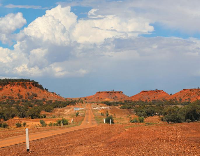
TOURIST ITINERARY BOULIA TO WINTON – 362KM
Follow the Cobb and Co trail from Boulia through to Winton, travelling along the scenic Min Min Byway. This road leads you to the most direct route into Diamantina National Park. Make sure you stop at the ruins of the Hamilton Hotel and the old grave at the Min Min Hotel, where the first recorded Min Min Light sighting took place. Soak in the landscape at the Cawnpore Lookout, the region where the filming of Goldstone took place.
1
11km – Bendgeacca is a channel which eventually joins into the Burke River. A beautiful spot for a picnic amidst the gum trees and 120kmwaterhole.–Georgina River Crossing. Look out on the western side of the crossing for the historical river height markers which date back to the 250km1950’s.–Tobermorey Station is on the border of QLD and the NT. A working cattle station, Tobermorey also has a camping area and donga style accommodation. Diesel and unleaded fuel along with refreshments are also available at Tobermorey.
BOULIA TO BEDOURIE – 192KM
467km – Jervois Station – a working cattle station that offers a place to pull up for the night. Jervois has a camping area and refreshments available. Diesel and unleaded fuel is also available onsite.
As you travel into the southern tip of the Boulia Shire, watch as the scenery changes as you encounter the first glimpses of the red sand hills of the desert country. This road is fully sealed and almost double lane in width. Look out for the Tropic of Capricorn, Georgina River Crossing and the Vaughan Johnson Lookout, fondly known as the Loo with a View. Great photo opportunities along the way.


REGIONAL MAP 10 www.boulia.qld.gov.au Jericho BIRDSVILLEBEDOURIE McKinlayKynunaStonehengeDuchessDajarra Balfe’sCreekHomesteadNationalBladensburgPorcupineGorgeParkKajabbi ALICE SPRINGS AdavaleEmmetWindorahJundahStamfordIsisfordEromangaQuilpie Camooweal URANDANGIBOULIA Middleton HughendenNationalDiamantinaCreekJuliaPark NationalCurrawinyaPark NationalWelfordParkThargomindahLONGREACH Cunnamulla WINTON Cloncurry MOUNT ISA Richmond AUSTRALIASOUTHQUEENSLAND NORTHERN TERRITORY NEW WINTON LAVERTON SPRINGSALICE BOULIA THE OUTBACK WAY TO THE EAST - WINTON ......................(362km) Hamilton Hotel Site ...............................(70km) Min Min Hotel Site................................ (105km) Cawnpore Lookout (151km) Middleton Hotel (190km) TO THE SOUTH - BEDOURIE ............... (192km) Vaughan Johnson Lookout ............... (110km) TO THE WEST - ALICE SPRINGS (821km) Via the Outback WayAustralia’s Longest Shortcut Tobermorey........................................... (250km) Jervois (467km) Harts Range (604km) Gemtree (686km) TO THE NORTH - MOUNT ISA ........... (304km) Dajarra (150km) Urandangi (307km)

www.boulia.qld.gov.au 11 CAFES/RESTAURANTS Australian Hotel Restaurant P (07) 4746 3144 All your favourite home style cooked pub meals available in the bar, restaurant or takeaway. Lunch available Monday –Saturday. Dinner available 7 days a week. Ask the friendly staff about pizza and the hotel’s unique gourmet camel menu. Camels Rest Coffee Shop P (07) 4746 3158 Espresso coffee, cold drinks along with light meals including wraps, sandwiches, toasties and quiches. Eat-in or takeaway. Open Monday – Saturday. Maxie’s Cafe/Restaurant P (07) 4746 3144 Now serving fresh espresso coffee, cold beverages, wraps, toasties, sandwiches and homemade cakes. Riverside Roadhouse P (07) 4746 3131 E creationsoutstockedselectionortakeawayforBoulia’sriversideboulia@outlook.comonlylocallyoperatedstopfuelsupplies.Quickandeasyfoodisreadilyavailablesitdownforameal.Asmallofgroceryitemsareforsale.Besuretocheckthelocal’srange,acollectionofmaderighthereinBoulia! ACCOMMODATION Australian Hotel/Motel P (07) 4746 3144 13 motel rooms with ensuites, 9 hotel rooms with 2 shared bathrooms. All rooms airconditioned. Boulia Caravan Park P (07) 4746 3320 or 0427 021 002 E campingblocksharedcabin,3PoweredMaryscott.mb@gmail.comandunpoweredsites,ensuiteunits,1selfcontained1familyroom,1cabinfacilities.Amenitiesandlaundry.Greengrasssite. Desert Sands Motel P (07) 4746 3000 11 ensuite motel rooms and a 2-bedroom unit. Continental and cooked breakfast available. Packed lunches on request. OTHER BUSINESSES Bob’s Tyres P (07) 4746 3158 or 0419 775 769 Boulia Police Station P (07) 4746 3120 Boulia Post Office P (07) 4746 3129 Boulia Primary Health Centre P (07) 4746 2333 EMERGENCY ONLY P (Queensland000 Ambulance Service) Boulia Shire is serviced by the Royal Flying Doctors Dangi Bush Resort P (07) 4748 4988 Min Min Encounter and Tourist Information Centre P (07) 4746 3386 Min Min Store and Hardware P (07) 4746 3158 The Waddi Tree P (07) 4746 3026 FREE WI-FI ACCESS: Australian Hotel/Maxie’s Cafe Boulia Caravan Park Boulia Library Desert Sands Motel Min Min Encounter and Information Centre PUBLIC AVAILABLECOMPUTERSAT: Boulia Library Telstra 3 and 4G mobile and broadband services are available in Boulia. A public phone can be located in the main streets of Boulia and Urandangi SHIRE SNAP SHOT SHIRE MAYOR COUNCILLORS&

You will be hard pressed to find a country race day like this one. With a mix of local races as well as sky channel facilities, try your hand with lady luck. Don’t forget to wear your favourite race outfit for fashions of the field with categories for boys, girls, fillies and mares as well as colts and stallions. A day for the whole family with entertainment and food available throughout the event. Traditionally held in conjunction with the Easter Races are also the Boulia Rodeo and the Boulia Campdraft. KNOW
YOUR NEIGHBOURURANDANGIDAY, JUNE LADIES PAMPER SANDURANDANGIDAY,GREENS,BOULIA JULY NAIDOC WEEK AUGUST GOLF OPEN, BOULIA SEPTEMBER CWA SPRING FAIR, BOULIA OCTOBER GEORGINA CRICKET ASHES, URANDANGI NOVEMBER DIAMONDS AND DUST BALL (TBA), MELBOURNEBOULIACUP In true outback tradition, the Boulia Shire commemorates Australia Day, ANZAC Day and Remembrance Day. EVENTSCALENDAR
BOULIA RACE DAY
Known as the Melbourne Cup of the outback, the Boulia Camel Races should be on everyone’s list of events to attend. Loads of entertainment all weekend, including live bands and trackside fun. Make sure you get to be a spectator or competitor in the Camel Tagging Competition. Food and markets all weekend.
BOULIA CAMEL RACES
WHAT’S ON IN BOULIA 3RD EASTERWEEKENDWEEKEND MARCH GET TO


