PREPARATION OF INTEGRATED DEVELOPMENT PLAN FOR DURGAPUR TOWN
• • PIC. INDIA (SOURCE :WIKIPEDIA)
PIC. WEST BENGAL ADPA REGION (SOURCE :WIKIPEDIA)
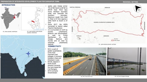
ADPA LIES FROM 23°53’ TO 23°56’ North to 86°48’ to 88°25’ East. River Ajoy forms Northern boundary while river Damodar the Southern boundary. Maximum length from East to West is 81 kms (approx.) while North to South is 27 kms. Since 2017, the ADPA converted to district called Paschim Bardhaman. It is surrounded on north by Dumka (Jharkhand), Birbhum and Murshidabad, in east by Purba Bardhaman, on south Hoogly, Bankura and Purulia and on west by Dhanbad (Jharkhand) districts.
SANTHAL PARGANA
BIRBHUM
ASANSOL-DURGAPUR PLANNING AREA
BARDDHAMAN
•
DHANBAD
INTRODUCTION
REGIONAL SETTING
PURULIA
BANKURA
PIC. ADPA REGION (SOURCE :AUTHOR)
CONNECTIVITY •
•
•
NH 2, a part of golden quadrilateral, is the most important road linkages. It connects Kolkata in East and Dhanbad in west. NH-60, aligned in North South direction connects Suri and meets NH2 at Raniganj. SH-9 connects Shantiniketan PIC. NH 19 near DVC more
PIC. SH 9 over Durgapur Barrage