


Magazine Issue 5, 2019/2020 SEA CAVE EXPLORER KAUA’I MAPS VOLCANIC KAUA’I LIVING ON NĀ PALI NA PALI COAST >> 26 >> 42 >> 12 NĀ PALI COAST PHOTO GUIDE >> 18 >> 4 This magazine is brought to you by: Call 808.742.6331 www.napaliriders.com


In this Issue ... VOLCANIC KAUA’I LIVING ON THE NĀ PALI 4 12 KAUA’I MAPS 18 NĀ PALI COAST GUIDE a publication from NA PALI RIDERS Raft Tours | Kaua’i NA PALI COAST Magazine www.napaliriders.com 808.742.6331 >> >> >> 26 >> Nā Pali Coast SEA CAVE EXPLORER >> 42 Nā Pali Coast Magazine is an inspirational magazine aimed at capturing the most breathtaking scenery found on the Nā Pali Coast of Kaua’i. We pride ourselves on creating a non-touristy, souvenir publication, for readers to take home with them as a keepsake from their visit to Kaua’i. Issue 5, 2019/2020 2 Na Pali Coast Magazine | 2019 / 2020

volcanic kaua’i
Story by Ani Turner
Rumble. rumble. The steep, plunging cliffs of Na Pali Coast stand as a true testament to Kauai’s great, volcanic past. These are the remnants of the Napali formation, the eroded cliffs of yesteryear, and the most spectacular visual display of geography in the world. 4 Na Pali Coast Magazine | 2019 / 2020 5 Call 808.742.6331 www.napaliriders.com
Photos by Na Pali Riders Raft Tours
Volcanic kaua’i
RED DIRT. There is great significance to the deep, orange hues that brightly paint the landscape throughout Kaua’i.

Once active volcanoes, the islands in Hawaii are primarily composed of basalt rock originating from hardened lava flows. The basalt rock is very rich in iron minerals. With extreme weathering over millions of years, the iron has oxidized, or rusted, resulting in the red-colored dirt found everywhere in the islands. Red dirt is soil of a clayey consistency, and is actually quite infertile.
The Hawaiian Island archipelago consists of 132 islands, atolls, reefs, shallow banks, shoals, and seamounts, and spans a total length of sixteen-hundred miles. The continuous northwestward movement of the Pacific Tectonic Plate across the fixed Hawaiian Magmatic Hot Spot is responsible for the formation of the entire Hawaiian Island chain. Incredibly, islands have been forming from this fixed hot spot for over 80 million years.
Kaua’i is the northernmost island of the eight, main Hawaiian islands, but the entire island chain extends much further: from The Big Island of Hawai’i in the west, to Midway and Kure in the east. Initially, Kaua’i was located where the Big Island of Hawai’i is today. As you move from west to east, the islands become younger. For example, the Big Island of Hawai’i is the youngest island in the Hawaiian Island chain, and is still quite volcanically active. To the southeast of it lies Lo’ihi Seamount, Hawai’i’s newest submarine volcano which is completely underwater at this time. Lo’ihi could become Hawaii’s newest island when it breaks the surface of the ocean some day.
Kaua’i is the oldest of the main Hawaiian Islands, but just exactly how old is Kaua’i? Geologists have concluded that the island is at least 5.1 million years old, with chemical testing indicating that Kaua’i contains rocks between 5.6 to 3.8 million years old.
(Continued on next page)
Kauai’s rich volcanic history is the reason for the deep, orange hues that brightly paint the hills and valleys across the island. The burnt orange color of this eroded cliff is caused by the high content of iron oxide in the soil. Kaua’i has experienced intense weathering over millions of years, and the red clay soil is a direct result of an extremely wet and windy climate.
Hikers pause for a break on the Kalalau Trail. Vibrant, orange hues paint the landscape, creating incredibly beautiful scenery on one of the most challenging hikes in the world. The Kalalau Trail draws hundreds of visitors each year.
7 Call 808.742.6331 www.napaliriders.com 6 Na Pali Coast Magazine | 2019 / 2020
Volcanic kaua’i
There has been some argument over whether Kaua’i formed from a single, major volcano or more than just one. A 2010 study from the University of Hawai’i revealed that there were actually two major shield volcanoes responsible for the island’s formation, one on Kaua’i and one in the region between Kaua’i and Ni’ihau. Ni’ihau is the island located west of Kaua’i, and is therefore the remnant of the first major volcano.
Once dome-shaped, Kaua’i’s physical appearance has gone through many phases over the past 5 million years. First arising from a submarine volcano (e.g. an undersea volcanic eruption), the island formed when the eruption finally broke the surface of the ocean as a central shield volcano, followed by landslides, shield collapse, erosion, and a series of more volcanic eruptions.
The northwestern portion of the Na Pali Coast boasts a spectacular display of an advanced state of erosion caused by extreme weathering over millions of years. Here, ridges have eroded so severely that they stand nearly upright and form curtain-like vertical folds rarely seen elsewhere in the world.
There continues to be a constant state of erosion occurring on Kaua’i, and this will eventually lead to the shrinking of the island back into the ocean. Scientists predict this may happen in 2-3 million years.
Kaua’i is fourth in size among the main Hawaiian Islands at 555 square miles of land— it’s 33 miles long and 25 miles wide. Its highest point is near the center of the island at Kawaikini Peak at 5,170 feet. Second highest is Mt. Wai’ale’ale at 5,148 feet. Mt. Wai’ale’ale is the center of a large volcanic mountain from which lava flowed down on all sides, and is the largest shield volcano in the Hawaiian Islands. Mt. Wai’ale’ale is literally the wettest spot on earth, with some portions of the summit recorded as receiving 600 inches of rain per year. All of this water feeds the island’s vegetation on a consistent basis, creating waterfalls, streams, verdant valleys and spectacular green and orange cliffs that have given Kaua’i its nickname of “The Garden Isle.”
The Nā Pali Coast of Kaua’i is an example of a shoreline that has been severely eroded by wave action. In the winter months, it is customary for the north and northeast-facing shores to receive surf with heights of up to 40 feet. This wave action is further intensified when combined with consistent Hawaiian trade winds and rains which cut through the porous rocks like knives. Spectacular sea arches and sea caves have formed in the cliffs as a result of the relentless pounding Hawaiian surf. Sometimes, overhanging arches crash to the ocean below, creating sea cliffs with sheer drops.
The sea cliffs along Nā Pali Coast provide an opportunity to see what happens internally when a

(Continued on next page)

9 Call 808.742.6331 www.napaliriders.com 8 Na Pali Coast Magazine | 2019 / 2020
volcanic cone erupts. The pressure from hot, liquid magma forms cracks in the existing hardened, lava beds. This hot lava then flows into the cracks, and cools slowly over time. The resulting lava dikes are the “veins of the volcanic rock.” One could map out the dikes’ directions, to determine roughly where the center of the original volcanic cone was once located. Dikes appear as vertical and slightly diagonal strips, and are up to several feet in width. They are easy to spot because they run perpendicular to the layers of basalt rock in the cliff.
A Note to the Reader: All of the photos in this magazine were taken by the photographers of Na Pali Riders Raft Tours. While the raft cruised along the rugged shoreline of Nā Pali Coast tour after tour, thousands of photos were captured, from which a few exceptional shots were chosen for this publication. We invite you to take a raft tour with Na Pali Riders during your visit to Kaua’i. Call 808.742.6331 to reserve a tour, or visit our website at www.napaliriders.com. Mahalo!
Volcanic kaua’i
Spectacular sea arches and sea caves have formed in the cliffs as a result of the relentless, pounding Hawaiian surf, which reaches heights up to 40 feet in the winter months.

The sea cliffs along Na Pali Coast provide an opportunity to see what happens internally when a volcanic cone erupts. The pressure from hot, liquid magma forms cracks in the existing hardened, lava beds. This hot lava then flows into the cracks, and cools slowly over time. The resulting lava dikes are the “veins of the volcanic rock.” One could map out the dikes’ directions, to determine roughly where the center of the original volcanic cone was located.

11 10 Call 808.742.6331 www.napaliriders.com Na Pali Coast Magazine | 2019 / 2020
Living on ... Na Pali Coast

When looking at the sharp, sheer cliffs and rugged terrain of the Nā Pali Coast, it seems like an impossible place for people to have lived. Yet, when the first Polynesian settlers sailed to Hawai’i in A.D. 850, they were quite enchanted by the pleasant, Hawaiian climate and plentiful amounts of natural resources. Wasting no time, they adapted to the Island’s challenges and set up camp.
Utilizing double-hulled voyaging canoes, the settlers brought everything they would need to successfully inhabit the Island. Among these items were coconuts for planting trees, taro ( kalo ) root, sugarcane, wild ginger, banana plants, ti plants, breadfruit, and yams. They also brought livestock such as pigs, chickens, and even dogs.
The fringing reefs of Kaua’i, built up over time by the year-round, warm temperature of the sea water, created the perfect setting for a
variety of edible marine life to inhabit. This was excellent for the women and children to obtain seafood from, and created a highlynutritious diet for their families.
One notable fishing site was Nā Pali’s Nu’alolo Kai reef, which juts out into the sea, forming a natural jetty that protects the inner bay from the strong, northeast trade winds which bring crashing waves to this area year-round.
Nu’alolo Kai’s reef teemed with fish and other wildlife such as sea turtles, seaweed, and edible sea shells, making life here quite sustainable for Kauai’s early inhabitants.
Despite living in an abundant paradise, life for the settlers was not entirely easy. Their daily reality was to survive against the harsh and quickly changing elements that nature presented to them.
During the winter months, the ocean and much of the shoreline was made inaccessible
by the pounding giant surf which could reach heights of 40-feet at times, making it all but impossible to launch the fishing canoes.
Luckily, the settlers farmed taro, a root crop, which was relied upon as a staple in their diet. Taro is one of the most nutritious plants on earth, and valuable since none of the plant goes to waste. The corm of the taro plant may be pounded with a pounder into a gummy food called poi and preserved (e.g.semifermented) for later eating. Its leaves, when cooked, are spinach-like, vitamin-rich, and very delicious.
Kaua’i’s mountain slopes presented themselves green and lush with vegetation, which indicated that there was an abundance of fresh water available. The settlers built farming terraces with elaborate stone walls along the streams, which allowed for natural irrigation of their crops.
Materials required for housing and canoe
-building were abundant for the early settlers of Kaua’i. Two to three steep, treacherous trails led to a good supply of wood in the Kōke’e forests above the south end of Kalalau Valley. Eventually, the critical demand for firewood led the valley to become deforested, except for hala trees whose leaves, or lauhala, were used for making huts, mats and clothing necessities. The area appeared rather barren except for the occasional bread fruit or coconut tree. The most sacred koa trees were also spared in order to utilize them for making canoes.
During the rainy season, floods were expected and accepted as part of the lifestyle. They were respected for the fact that they brought the renewal of vegetation, but also feared for creating potential landslides or earth slumps on the high cliffs above—even long after the rains ceased.
(Continued on next page)
Ancient Hawaiians at work on Kalalau Beach. Nā Pali Coast, Kaua’i. Illustration by Brad Cate Design.
13 12 Call 808.742.6331 www.napaliriders.com Na Pali Coast Magazine | 2019 / 2020
on Na Pali Coast
There were always areas of dry sand which would be heated by the sun during the day. This created a place for the people to have a reprieve from the colder, wetter regions, where they could warm themselves naturally in the Hawaiian sun.
In the 1860’s, the Nā Pali Coast’s Kalalau Valley became used as a place to send persons afflicted with leprosy (e.g. Hansen’s Disease). Since Kalalau Valley is surrounded on three sides by steep cliffs, opening out to the sea at the front, its remoteness was therefore much appreciated by the Hawaiian government as well as the leprous people who wished to live in seclusion away from judgement. It is estimated that by the late 1890’s, as many as thirty-five leprous persons were living in Kalalau alongside many other people who were non-leprous.
Most Hawaiians had moved out from Kalalau by the early 1900s to the safer, less remote areas of Kauai.
Nā Pali Coast Today. The Nā Pali Coast is today viewed and visited by no less than a half a million visitors per year. Like the first Polynesian settlers who discovered it, visitors feel a magnetic attraction towards the peaceful paradise that it represents. One’s eyes are treated to views of multi-colored, lush, green, fluted cliffs, massive pinnacle-shaped lava dikes, and cascading, crystal clear waterfalls complete with misty and vibrant rainbows.
There’s no mystery why Hollywood has maintained its presence here. The Nā Pali Coast has been wellpublicized the world over in films from Pirates of the Carribean to King Kong , from Six Days Seven Nights to Jurassic Park . Indeed, it is a very sought-after part of the world.
Getting There. The majority of visitors will rent a vehicle and drive to the summit point at Kōke’e. Here, at the Kalalau Lookout, they will view the Nā Pali Coast’s Kalalau Valley 4,000-feet below, between mystic, parting clouds.
Another way to see the Nā Pali Coast is by sea in a kayak, boat, or raft. In a motorized-craft, you are taken to the remote coastline’s famous sites in leisure, with little effort. Kayaking is much more strenuous and requires an experienced guide.
Those more daring may hike the treacherous 11-mile Kalalau Trail and experience the Nā Pali Coast scenery face-toface. However, only attempt this if you are well-educated on the terrain of the trail which is extremely difficult for even the most-experienced hiker.
Lastly, one can view the Nā Pali Coast from a helicopter. This is awesome, since it gives passengers a birds-eye view of the entire island of Kaua’i.
The message here is to visit this awe-inspiring site firsthand, because the photos are just a glimpse of what you will see when you are on the Nā Pali Coast. It is a place rich in history and without a doubt, a highly spiritual and sacred place. Today, there are still a few die-hard hippies living in the caves deep in Kalalau’s interior, living on welfare checks, and eluding the site-visits from the officers at the Department of Land and Natural Resources who are always checking for unpermitted campers.
Nu’alolo Kai
Na Pali’s Nu’alolo Kai reef juts out into the sea , forming a natural jetty that protects the inner bay from the strong, northeast trade winds that bring crashing waves to this area year-round. In ancient times, the protected reef teemed with fish and other wildlife such as sea turtles, seaweed, and edible sea shells, making life at Nu’alolo Kai quite sustainable for Kauai’s early inhabitants.
Depiction of a fishing village that once existed at Nu’alolo Kai on the Nā Pali Coast. Illustration by Brad Cate Design.

15 14 Call 808.742.6331 www.napaliriders.com Na Pali Coast Magazine | 2019 / 2020


10 Must Things to Do in Kaua’i 1 Raft Tour of Nā Pali Coast 2 Do a Hawaiian Lū‘au 3 Hike Nā Pali Coast 4 Snorkel at a Reef 5 Visit a Farmers’ Market 6 Visit the National Tropical Botanical Garden 7 Bike the Coconut Coast 8 Eat Shave Ice 9 Visit Kamokila Hawaiian Village 10 Hang at the Beach The cartograph above is provided by Lahaina Printsellers Visit their web site for other exceptional art having to do with Hawai‘i. www.printsellers.com Map of Kaua’i Island 17 16 Call 808.742.6331 www.napaliriders.com Na Pali Coast Magazine | 2019 / 2020
Exploring Kaua’i

Roads

Dirt Roads
Hiking Trails
Snorkel Spots
Surf Spots
Note of Caution: The waters around Kaua‘i are known for dangerous currents, large surf, shore breaks, and sneaky waves. It is critical that you check ocean conditions and consult with a lifeguard before going into the water.


Lifeguarded Beaches: Anahola Beach, Haena Beach, Hanalei Pavilion, Ke’e Beach, Waioli Beach Pine Trees


Kīlauea Kē’ē Beach
K
Taro Fields in Hanalei
Peaceful Hanalei Bay
īlauea Lighthouse
KalalauTrail2Mi. 4Mi. Ka Haku Rd Anini Rd KalihiwaiRd Lighthouse Rd KilaueaRd Kalihiwai Rd Wailapa Rd N. Waiakalua Rd WekeRd Aku Rd Kuhio Highway Ko‘olauRd Moloa‘aRd Anahola Rd
North
19 18 Na Pali Coast Magazine | 2019 / 2020 Call 808.742.6331 www.napaliriders.com 2018
Shore
Exploring Kaua’i East Side


Dirt Roads
Hiking Trails

Snorkel Spots
Surf Spots

Note of Caution: The waters around Kaua‘i are known for dangerous currents, large surf, shore breaks, and sneaky waves. It is critical that you check ocean conditions and consult with a lifeguard before going out into the water.

Lifeguarded Beaches:
Wailua Falls Eucalyptus
Opaeka’a
Kipū Ranch MoalepeTrail NounouMtTrail Kuamo‘oNounouTrail Kawaihau Rd Kuamo‘oRd Ma‘aloRd RiceSt Ahukini Rd NāwiliwiliRd HaleilioRd ‘OlohenaRd Kamalu KainaholaRd Kapa‘aBypass Kuhio Highway Kuhio Hwy KapuleHwy Kaumuali‘iHwy Kuhio Highway Mailihuna PowerlineTrail Kuilau Ridge Trail
Grove
Falls
Roads
Anahola Beach
21 20 Call 808.742.6331 www.napaliriders.com Na Pali Coast Magazine | 2019 / 2020 2018
Kealia Beach Lydgate Beach


South Shore Cliffs Beach Po‘ipū Beach Park Po‘ipū Beach Po‘ipū Beach Spouting Horn RiceSt NāwiliwiliRd Lawa‘iRd KōloaRd Ala Kinoiki (Koloa–Po‘ip ū Bypass) Po‘ip ū Rd Maluhia Rd Po‘ipūRd HalewiliRd Kaumuali‘iHwy Kaumuali‘iHwy Kaumuali‘iHwy 23 22 Call 808.742.6331 www.napaliriders.com Na Pali Coast Magazine | 2019 / 2020


Waimea Pier Waterfall next to Koke‘e Road Waimea Canyon Exploring Kaua’i Kaumuali‘iHwy KekahaRd Military Boundary Kaumuali‘iHwy Waimea Canyon Rd Koke‘eRd Check-in Point Nā Pali Riders Raft Tours Call 808.742.6331 www.napaliriders.com 25 24 Call 808.742.6331 www.napaliriders.com Na Pali Coast Magazine | 2019 / 2020
Exploring Kaua’i
Roads
Dirt Roads
Hiking Trails
Snorkel Spots
Surf Spots
Note of Caution: The waters around Kaua‘i are known for dangerous currents, large surf, shore breaks, and sneaky waves. It is critical that you check ocean conditions and consult with a lifeguard before going into the water.
Lifeguarded Beaches: Anahola Beach, Haena Beach, Hanalei Pavilion, Ke’e Beach, Waioli Beach Pine Trees
Kīlauea Kē’ē Beach
K
Taro Fields in Hanalei Peaceful Hanalei Bay
īlauea Lighthouse
KalalauTrail2Mi. 4Mi. Ka Haku Rd Anini Rd KalihiwaiRd Lighthouse Rd KilaueaRd Kalihiwai Rd Wailapa Rd N. Waiakalua Rd WekeRd Aku Rd Kuhio Highway Ko‘olauRd Moloa‘aRd Anahola Rd
27 26 Call 808.742.6331 www.napaliriders.com Na Pali Coast Magazine | 2019 / 2020
Wailua Falls Eucalyptus Grove Opaeka’a Falls Kipū Ranch MoalepeTrail NounouMtTrail Kuamo‘oNounouTrail Kawaihau Rd Kuamo‘oRd Ma‘aloRd RiceSt Ahukini Rd NāwiliwiliRd HaleilioRd ‘OlohenaRd Kamalu KainaholaRd Kapa‘aBypass Kuhio Highway Kuhio Hwy KapuleHwy Kaumuali‘iHwy Kuhio Highway Mailihuna PowerlineTrail Kuilau Ridge Trail 29 Call 808.742.6331 www.napaliriders.com 28 Na Pali Coast Magazine | 2019 / 2020
South Shore Cliffs Beach Po‘ipū Beach Park Po‘ipū Beach Po‘ipū Beach Spouting Horn RiceSt NāwiliwiliRd Lawa‘iRd KōloaRd Ala Kinoiki (Koloa–Po‘ip ū Bypass) Po‘ip ū Rd Maluhia Rd Po‘ipūRd HalewiliRd Kaumuali‘iHwy Kaumuali‘iHwy Kaumuali‘iHwy 31 Call 808.742.6331 www.napaliriders.com 30 Na Pali Coast Magazine | 2019 / 2020
Waimea Pier Waterfall next to Koke‘e Road Waimea Canyon Exploring Kaua’i Kaumuali‘iHwy KekahaRd Military Boundary Kaumuali‘iHwy Waimea Canyon Rd Koke‘eRd Check-in Point Nā Pali Riders Raft Tours Call 808.742.6331 www.napaliriders.com 33 Call 808.742.6331 www.napaliriders.com 32 Na Pali Coast Magazine | 2019 / 2020
NĀ PALI COAST


Note of Caution: The waters around Kaua‘i are known for dangerous currents, large surf, shore breaks, and rogue waves. It is critical that you check ocean and river conditions and consult with a lifeguard before going out into the water and/or crossing rivers/streams.


Nu’alolo Kai Beach 5Mi. Nu’aloloCliffTrail 2.1 Mi. HonopūTrail2.1Mi. Koke’e Rd. Kalalau Lookout Kalalau Beach KalalauTrail Hāʻena State Park PACIFIC OCEAN Nā Pali Coast: A Photographic Tour toHanalei toWaimea 9 10 11 12 13 5 8 6 3 3a 4 1 2 Kēʻē Beach Hanakāpīʻai Beach Ho ‘olulu Cove Waiwaipuhi Sea Cave Waiahuakua Valley Double-Door Sea Cave Hanakoa Valley 1 2 3 3a 4 5 6 7 Pōhakuao Falls & Sea Arch Kalalau Valley Honopū Beach Open-ceiling Cave Koke‘e State Park Hanakoa Lookout Mākaha Valley Mākole Polihale State Park Hanakāpīʻai Falls 8 550 9 10 12 13 Awa‘awapuhi Valley Nu‘alolo ‘Āinā Valley Miloli‘i Beach Miloli‘iRidgeTrail KalalauValleyTrail Hanakapiai Falls Trail KalalauTrail Nu’aloloTrail Awa‘awapuhiTrail 3.8Mi. 3.1Mi. 2Mi. 2Mi. 4Mi. 5Mi.
Roads Dirt Roads Hiking Trails Snorkel Spots
Mākaha Point 7 11 560 26 Na Pali Coast Magazine | 2019 / 2020 27
1 KE‘E BEACH

Kē’ē Beach is located at the end of the north shore’s road on Kaua’i. It is also known as the gateway to the Nā Pali Coast by way of the Hanakāpī’ai Trail and Kalalau Trail. As you face to the west, look to the left, and along the cliff, semi-covered by a coconut tree jungle, protrudes an area of black lava rock walls. This is the heiau complex at Kē’ē, home of the sacred hula goddess Laka. The setting of this heiau at Kē’ē Beach is about as exotic as it comes in Hawai’i.


Just outside of the reef the ocean turns a deep, cobalt blue color. In the early morning look for dancing Hawaiian Spinner dolphins here, as they perform like jesters in the royal court of Laka.
2 HANAKAPI ‘AI
The Hanakāpī’ai Trail is a 2-mile hike from Kē’ē Beach, and takes you to Hanakāpī’ai Beach, a sandy beach surrounded by a heavenly rainforest-like valley. A natural ammonia scent fills the air, caused by fermenting guava fruit and tropical plants. Hiking further into the valley, one will discover an amazing waterfall which creates a refreshing, bubbling stream, which winds through the valley, cuts through the beach, flows over large boulders, and finally goes out to sea. Beware of the tempting ocean here —the Nā Pali Coast ocean currents are an invisible killer at this location, taking over 86 peoples’ lives through the years—when in doubt DO NOT go out.
Early season winter waves begin their onslaught on Hanakāpī’ai Beach.
B eware of the tempting ocean here , the n ā p ali c oast currents are an invisi B le killer at this location , taking over 86 peoples ’ lives through the years
 Left to right: Visitors sun and swim in the Ke’e lagoon, Hawaiian spinner dolphins play outside the reef, Heiau of the hula goddess Laka located slightly past the coconut grove
Left to right: Looking to the west end of the beach and beyond, Hanakāpī’ai stream on a summer day
Ke‘e Beach paradise and the gateway to the Nā Pali Coast
Left to right: Visitors sun and swim in the Ke’e lagoon, Hawaiian spinner dolphins play outside the reef, Heiau of the hula goddess Laka located slightly past the coconut grove
Left to right: Looking to the west end of the beach and beyond, Hanakāpī’ai stream on a summer day
Ke‘e Beach paradise and the gateway to the Nā Pali Coast
Nā Pali Coast: A Photographic Tour
36 Na Pali Coast Magazine | 2019 / 2020 37 Call 808.742.6331 www.napaliriders.com
HO ‘OLULU COVE

Ho’olulu means “protected bay or waters.“ The cove was once an area where ancient Hawaiian canoers took refuge. There are three sea caves at Ho’olulu. Noddy tern marine birds nest along the cliffs and inside the walls of the sea caves. The water here is an electrifying blue color, especially in the sea caves when the summer sun shines into them, reflecting off of the shallow, white sandy bottom.
Looking overhead one sees a towering cliff and an overhang of vegetation at the top of prominent Space Rock. Natural springs of water trickle over the bowl-shaped cliffs. The springs reflect the light of the sun beams, creating a magical display of color.

WAIWAIPUHI SEA CAVE
Waiwaipuhi Sea Cave means “great blowhole,” and was named this because the cave literally turns into a giant, spewing blowhole in the winter months when the pounding surf crashes against it. Boat captains have nicknamed it Pirate’s Cave. This cave has a large entrance, and is 951 feet in length.
VALLEY DOUBLE-DOOR CAVE
At 1,155 feet in length, the Waiahuakua Sea Cave is second on the list in rank for the world’s longest sea caves. This dark and spooky sea cave has a separate entrance and exit, and is nicknamed the Doubledoor Sea Cave. Inside the cave’s corridor, a lively waterfall gushes down through a hole in the ceiling. This is, hands-down, the most thrilling sea cave to explore on the Nā Pali Coast.


Nā Pali Coast: A Photographic Tour
Left to right: Kayakers deep in the Waiwaipuhi Sea Cave, cascading waterfall at the entrance
3
Looking from east to west towards Zebra Cave.
3a
4
WAIAHUAKUA
39 38 Call 808.742.6331 www.napaliriders.com Na Pali Coast Magazine | 2019 / 2020
Left to right: The water fall inside of the cave, the glowing light coming through the ceiling’s hole
5 HANAKOA VALLEY


Hanakoa Valley is often used as a halfway point camping station for those hiking the Kalalau Trail. A large portion of the Bali Hai Ridge is here, comprised of two lava dike ridges protruding up like sentries guarding both sides of the tropical rain forest valley. The back of the valley is surrounded by 2,000 ft. high cliffs, with a waterfall cascading down the middle of the ridge. Along the near-shore coast line one can’t ignore the bright orange-rust earth color created by red iron ore in the soil. In contrast to this color are the dark-green hala trees, which resemble something from a Dr. Seuss book. Further back on the ridge, sisal plants thrive, resembling 20-foot high asparagus stalks. The valley was once terraced for taro farming, and later for coffee plants.
the crystal clear waterfall splits like the fangs of a snake , as it slithers and falls into the ocean ’ s electric green water B elow

The Nā Pali Coast Sea Arch is highlighted by Pōhakuao Falls in the background. When sea conditions are extremely calm, smaller vessels (e.g. rafts and kayaks) may travel right through the arch. Upon exiting, you will be treated to a panoramic view of the entire Nā Pali Coast. Cool, misty spray coming off of the waterfall is a refreshing treat on a warm, summer day.


Nā Pali Coast: A Photographic Tour
Left to right: East valley peak, middle of the valley, east valley ridge on a summer day.
The two ridges left and right of the valley make up a large portion of the Bali Hai Ridge, made famous from the movie South Pacific
Left to right: Looking east into the Sea Arch on a summer day, the Sea Arch entrance
6 POHAKUAO FALLS & SEA ARCH 41 40 Call 808.742.6331 www.napaliriders.com Na Pali Coast Magazine | 2019 / 2020
Looking west through the sea arch is a panoramic view of the Nā Pali Coast
KALALAU VALLEY


The 11-mile Kalalau Trail comes to an official end at Kalalau Beach. Depending on the season, Kalalau Beach may be a narrow strip of sand, or a long, expansive, sandy beach. Hikers must obtain a permit to camp overnight here, and it is highly recommended to do so as the treacherous Kalalalu Trail demands recovery with a good night’s sleep before returning to Kē’ē Beach.
The spell-binding Kalalau Valley forms the backdrop to the beach, and is famous for the dramatic peaks and pinnacles which shape the interior walls of the valley. Bowl-shaped and tucked within mountainous walls of rain forests, it’s 3-miles in diameter. Kalalau’s mystic spell is felt in the quiet air that surrounds it, broken only momentarily by tour helicopters that appear like tiny, hovering mosquitoes high above in the distant sky. The valley’s west wall ends toward the sea in cascading cathedrals of stone, with lava dikes thrusting upwards, together forming three towering, knife-edged pyramids, commonly referred to as the “Guardians of Kalalau.” They take command of their valley, steadfast and true, and are the second highest sea cliffs in the world.
To truly describe Kalalau is to compare it biblically, as Kauai’s very own “Garden of Eden.” There are hidden delights in the valley such as cascading waterfalls, slippery-slides carved into boulders from millions of years of water flows, and fairy tale-like streams flowing gently through a mystic, hobbit-like valley.
HONOPU BEACH
For Hollywood (a.k.a. “Nā Pali-wood”), Honopū Beach is a favorite movie filming location. Six Days Seven Nights King Kong and Pirates of the Caribbean are just a few productions that easily come to mind. Honopū Beach made its most famous Hollywood debut in Goldfinger when James Bond is seen riding in a red helicopter, being chased under and through Honopū’s natural seaside archway.
Honopū is also known as “The Valley of the Lost Tribe.” This name refers to ancient times when this now silent, brooding valley was believed to be the setting for a group of mythical Mū people, who later vanished for no apparent reason. It is also believed that the upper valley was inhabitated by ~300 Hawaiians. They would have been shielded from invaders by the 3,000-foot high, sheer cliffs that line the back of the valley. Visitors have reported feeling a very uncomfortable, eery presence at Honopū, and it is believed that ancient spirits still wander forlornly through the valley.
Nā Pali Coast: A Photographic Tour
7
Kalalau grotto in the foreground with the Kalalau cathedrals in the background
8
a perfect sun-lit day. 43 42 Call 808.742.6331 www.napaliriders.com Na Pali Coast Magazine | 2019 / 2020
Honopu Beach and valley
on
OPEN-CEILING CAVE
The Open-ceiling Cave, also known as Queen’s Bath, is actually a hollowed-out lava tube (e.g. the ceiling has crashed into the sea floor below). When you are inside of the cave, you can literally look upwards to view the sky above. In the summer season, the mid-morning sunlight streams through the cave’s dark entrance, penetrating the crystal-clear waters and reflecting off of the white, sandy bottom. The result is a boldly blended color palette of electrifying blues and greens—it’s truly spellbinding.


10 AWA‘AWAPUHI VALLEY
Awa‘awapuhi is the narrowest and deepest of Nā Pali’s remote, isolated valleys. Some say the name refers to the valley’s sinuous curves and twists that wind between its 3,000-foot walls, like a slithering eel, or puhi. There is another legend that the valley s named for the wild ginger, or ‘awapuhi that grows here. Revered for its decorative and fragrant flowers, ‘awapuhi also has many practical uses—for food and fiber, and most notably for the natural shampoo that oozes from its flowering stalk.

Nowadays, this valley (awa) of the wild ginger appears far less lush than it was in ancient times, since the irrigated terraces for cultivating taro plants have long since fallen away. By sea, the valley itself is hidden from view by towering cliffs, for it hangs above a low sea cliff, with the valley’s main stream ending in a waterfall to the sea. At the base, there is now a tall natural screen of
dark green hau, a native Hawaiian bush from the hibiscus family, whose bark was once used for rope-making. There can still be seen a multitude of half-washed away rock dams that at one time went completely through the stream to create perfect terraces for growing taro.
On its western side, at the point overlooking the ocean, is a rock wall heiau, or temple platform designed for worship. It could be the place where the gods of the sea and fishing were once supplicated, or perhaps a dedication site to Ku, the god of war, to whom human sacrifice and cannibalism was sometimes offered.
Nā Pali Coast: A Photographic Tour
The Open Ceiling Cave is a heavenly place.
Left to right: Looking up towards the sky through the hole in the ceiling, looking out towards the sea from inside of the cave, passing by the cave’s entrance
9
45 Call 808.742.6331 www.napaliriders.com 44 Na Pali Coast Magazine | 2019 / 2020
NU‘ALOLO AINA VALLEY
Nu‘alolo ‘Āinā is remarkable for the remains of taro-growing terraces visible by sea. People resided in this valley for hundreds of years, well into the early 20th century. Adjacent to it, and once connected by a primitive ladder over the separating cliff, is the Nu’alolo Kai Beach and Valley, which also contains multiple, elaborate lava rock terraces visible from the ocean.
The terraces left at Nu’alolo ‘Āina are a reminder that a substantial amount of taro was grown here. With the steep topography of the valley one has to wonder if the farmers were able to produce enough taro to feed the local population, on a
consistent basis. With frequent devastations to crops caused by landslides and flash floods, it was surely a challenge to produce enough crop. This became especially challenging in the winter season when fishing or reef gleaning were made impossible by dangerously high surf crashing against the shorelines and cliffs.

Taro, or kalo, grows in watery paddy fields and upland rainy areas, and is considered a perfect food plant all around. Its heart-shaped green leaves have a delicious, spinach flavor, while its starchy tuber is similar in consistency to a potato.
NU‘ALOLO KAI
Nu‘alolo Kai Beach was the portal to the sea for the people of the adjoining Nu’alolo ‘Āina Valley. A trail and ladder down the separating cliff led to this location which boasted a freshwater spring, expansive beach and and abundant coral reef. A premier fishing village once flourished here, though only traces of it now remain. While plantings behind the beach provided some food and medicine for the people, it was the surrounding reef that was most prized for its supply of multicolored fish, seaweeds, and shellfish, such as ‘opihi limpets and pipipi snails. Even sharks were caught, like the white-tip reef shark. Fish and turtle pens were probably set up to hold live catches until they were ready to be eaten. Outrigger canoes most likely lined the beach, ready for offshore fishing when schools of oceanic fishes like aku, akule and ‘ōmilu came near.

The reef, of the fringing type, is shallow and extends out from the sandy beach like a natural jetty. Besides
providing seafood, it also buffered the persistent onslaught of trade wind swell that rolls in nearly 80 percent of the year. At the lowest tides, half of the reef top will be above water, and virtually dry, the summer sun toasting its crop of golden brown seaweed. This marine plant, a kind of Sargassum (as in the Sargasso Sea) is a favorite food of resident green sea turtles. For a depiction of how ancient people may have lived at Nu’alolo Kai, see pages 14-15.

Nā Pali Coast: A Photographic Tour
11
12
47 46 Call 808.742.6331 www.napaliriders.com Na Pali Coast Magazine | 2019 / 2020
Green sea turtles bask in the sun
MILOLI‘I BEACH
Miloli‘i Beach is a wide, expansive beach and a favorite camping and resting spot for kayakers during the spring and summer months, when the Nā Pali Coast becomes calm enough for day trips. The beach at Miloli‘i, with its warm and dry, sagey air, is a welcome respite for weary travelers.
Miloli‘i is a small valley that soon becomes a narrow passage between dry, 1,500-foot walls. It gets less than a quarter of the rainfall compared to nearby Kalalau Valley, yet its stream still flows year-round, making it one of the few Nā Pali Coast


valleys having perennial water. This made human settlement here possible for the native population. Besides being a source of life-giving water, the stream was the home to native shrimp and ‘o‘opu gobys (the latter is a fish famous for having a ventral sucker that enables it to climb up waterfalls). These animals spend the early stages of their lives in the sea, and later ascend and colonize the mountain streams.
The Miloli‘i people also farmed taro on the back shore flats behind the beach, and fished the sur-
rounding fringing reef, whose bounty is revealed even today by the plethora of shells it offers to collectors.
During the winter months, Hawaiian green sea turtles take shelter on the sandy beach (to avoid the tiger sharks hunting the murky wave-stirred shoreline). An endangered Hawaiian monk seal is often found sleeping on the beach, probably digesting its belly full of fish and resting for its next hunt.
Unlike Kalalau, there is no connecting hiking trail into Miloli‘i. It is accessible only by small boat or kayak, and the narrow channel through the reef is especially tricky to navigate when the tradewinds are blowing strongly.

Nā Pali Coast: A Photographic Tour
Top to bottom: Busy summertime kayak season, over looking the beach, and orange cliff stain of the seasonal waterfall, the cliffs do an imitation of the Grand Canyon.
13
49 48 Call 808.742.6331 www.napaliriders.com Na Pali Coast Magazine | 2019 / 2020
Sea Cave Explorer
i t is the calming spring and summer time conditions on the n ā pali c oast that allow our raft the B est chances to enter the sea caves and arches .
CaveSea E x plor E r
Ialways know this question is coming,“Will we be able to get into the sea caves today?”
I reply that it is never a guarantee, every day the ocean conditions can change, and we will enter as long as we can exit as well.
The caves on Nā Pali Coast are highly alluring. They represent mystery and magic, they are Mother Nature’s creation. Most will admit to never having seen anything like them before.
“How did this form”? What makes that heavenly, Windex-blue color glow in the Open Ceiling Cave? How did the waterfall form there? What kind of birds are nesting in there? What movies were filmed here?” The onslaught of questions fire at me like a machine gun from the excited passengers, but the truth is that I am just as excited as they are.
You can’t get into the sea caves every day, but when you do, it is always a new experience. Let
Nā Pali Riders Raft Tours describe in detail the caves and arches you will be visiting on the Nā Pali Coast of Kaua’i.


y ou can ’ t get into the sea caves every day , B ut when you do , it is always a new experience .
Inside the Open-ceiling Cave
Story by Captain Chris Photos by Nā Pali Riders
Inside Zebra Cave at Ho’olulu 51 50 Call 808.742.6331 www.napaliriders.com Na Pali Coast Magazine | 2019 / 2020
A gushing waterfall flows inside of the Waiahuakua Sea Cave
Sea Cave Explorer


Open Ceiling Cave
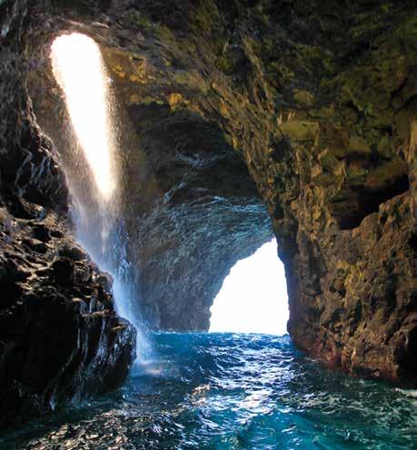
First visit is the Open-ceiling Cave. Also known as Queen’s Bath, the Open-ceiling Cave is the world’s most impressive example of a littoral sink. Here, the ceiling has collapsed entirely into the sea floor below, creating a cylindrical chamber that measures ~150-feet in diameter. A narrow, seaward entrance allows small boats and kayaks to enter the cave and perform a circular route around the interior rock island. The depth inside the cave is 65-feet.
The entrance to the Open Ceiling Cave with its heavenly, blue color
On a calm, summer day the raft can navigate through the Open Ceiling Cave 53 52 Call 808.742.6331 www.napaliriders.com Na Pali Coast Magazine | 2019 / 2020
Sea Cave Explorer
Honopu Sea Cave has its own unique features and views. As you enter, glance back at the waterfall which is framed in by the cave’s entrance. Look for schools of small fish hiding in the shadows and possibly a white-tip reef shark looking to make a meal out of those fish. See nesting seabirds in the crevices of the walls. As you get deeper into the cave, the walls of the cave edges stand out even more. The grayish-black lava rock contrasts with the pinkish-red coral growing at the surf line.
Honopu Sea Cave


55 54 Call 808.742.6331 www.napaliriders.com Na Pali Coast Magazine
i ts ominous cliffs tower over 3,000 feet , with fluted walls contrasting from lime to dark green .
Honopu Sea Arch


Honopu Sea Arch is a popular Hollywood movie setting. Many movies have been made at this location, including Pirates of the Caribbean King Kong, and Goldfinger with the dramatic helicopter scene of James Bond flying right through the arch. There is an air of mystery here, for the backdrop of Honopu Valley has been nick-named “Valley of the Lost Tribe.” Its ominous walls tower over 3,000-feet high. Many stories are told of this valley as being haunted by ancient warrior spirits of long ago.
Call 808.742.6331 www.napaliriders.com

Sea Cave Explorer
57 56
Na Pali Coast Magazine | 2019 / 2020
Na Pali Sea Arch is around the corner from Hanakoa Valley. On rare occasions when the sea conditions are calm, the experience of rafting through the Sea Arch may be realized. Upon exiting, the view looking west is truly a “post card moment” capturing a panoramic view down the Nā Pali coastline with waterfalls plunging into the sea from rugged sea cliffs above, and the expansive Pacific Ocean all around.

Na Pali Sea Arch


t he view looking west as you B egin to exit the arch is truly a “ post card moment ” ...
808.742.6331
Sea Cave Explorer
59 58 Call
www.napaliriders.com Na Pali Coast Magazine | 2019 / 2020
Waiahuakua Sea Cave
Waiahuakua Sea Cave.
The Waiahuakua Sea Cave is 1,155feet long, making it the largest of the Nā Pali sea caves, and the second longest sea cave in the United States. Waiahuakua Sea Cave means “sacred water” but is known to most as the Double Door Cave because it has a separate entrance and exit. ~200feet into the cave, a littoral sink allows a perennial waterfall to gush down the cave’s western wall. When the afternoon summer light shines through the hole, a glowing spotlight appears in the water below.


a s your eyes adjust to the darkness , you are pleasantly surprised with a waterfall inside the corridor Sea Cave Explorer 61 60 Call 808.742.6331 www.napaliriders.com Na Pali Coast Magazine | 2019 / 2020
Sea Cave Explorer
Waiwaipuhi Sea Cave is nick-named the Pirates Cave, but literally translates to “great blowhole,” because in the winter months, the crashing surf turns the cave into a powerful blowhole that spews water straight back out to sea.


Waiwaipuhi Sea Cave
a rushing waterfall guards its entrance , providing each passenger who dares to enter with a cool , freshwater shower 63 62 Call 808.742.6331 www.napaliriders.com
Ho’olulu Cove
Ho’olulu Cove lies below Ho’olulu Valley, and is ~4 miles in on the Kalalau Trail. Ho’olulu means “protected bay or waters.” Ho’olulu Cove is surrounded by three caves.
On the far right is the Zebra Cave with stripes of white calcium against black lava; in the middle is the Godzilla Egg Cave with big round rocks covered in bright pink corals; and to the left is the Skull Cave shaped like a skull.

Ho’olulu Cove once served as a resting spot for ancient Hawaiian canoers who referred to the area as Pā Ma Wa’a.
It still provides the same refuge for present-day Nā Pali Coast kayakers.


Sea Cave Explorer
65 64
808.742.6331 www.napaliriders.com Na Pali Coast Magazine | 2019 / 2020
Call
Got Coconuts? ~Coconuts, Probiotics, and a Happy Gut~

Heralded as nature’s sports drink, coconut water continues to gain popularity as a healthy and natural alternative to sports drinks like Gatorade. In its raw state, coconut water is incredibly rich in potassium and electrolytes, and low in sugar and calories. It’s no wonder that America has a love affair with coconut water!
At KEĀLIA FARMS, we’ve decided to take coconut water to a whole, new level, with a probiotic version of it called COCONUT WATER KEFIR. It’s a highly beneficial beverage created from 100% Kaua’i-grown, USDA certified-organic, young coconuts. Everything in our coconut water kefir is local, fresh, and highly nutritious.

What is Kefir?
The word kefir comes from the Turkish word for “good feeling.” Kefir is an ancient, cultured beverage. The water kefir culture, when added to fresh coconut water, feeds off of the natural sugars found in the coconut water to produce COCONUT WATER KEFIR. Coconut water kefir is a true living food, full of billions of beneficial probiotic bacteria for a healthy gut, and natural electrolytes found in the coconut water. It can provide a multitude of benefits such as:
• Alleviate kidney stones with high potassium levels found in the coconut water.
• Protect heart health against high blood pressure, irregular heartbeat, blood clots, and heart attack.
• Guard against food-borne pathogens with seven different strains of probiotic bacteria and yeast.
• Control opportunistic yeast growth, like Candida.
• May fight cancer and boost immunity with probiotics.
• May reduce the spread of cancerous cells.
If you’re looking for a natural way of rebuilding and maintaining your gut health, coconut water kefir may be the answer.

Where Can I find It?
KEĀLIA FARMS COCONUT WATER KEFIR may be found at the Kaua’i Community College Farmers Market on Saturdays 9:30am-1:00pm, and in the refrigerated section of health food stores on Kaua’i. For more information, visit www.kealiafarms.com or email info@kealiafarms.com.
COCONUT WATER KEFIR in original and passionfruit flavors, a seriously healthy probiotic beverage .
58 Na Pali Coast Magazine | 2019 / 2020 59
Kaua’i-grown, organic, young coconuts called Niu Hiwa (dark green) and Niu Lelo (yellow). Fresh coconut water is extracted from the coconuts, and cultured with kefir.
Farmers’ Markets
Are you a locavore? Do you want to be fully immersed in the local community of Kaua’i farmers and island food artisans? Well, there is no easier way to buy and consume only Kaua’i-grown and Kaua’i-made products than by visiting one of the weekly Kaua’i Farm Bureau Farmer’s Markets on Kaua’i.
Filled with vendors selling tropical produce and unique food inventions, Kaua’i’s Farmers’ Markets are an excellent way to eat and buy local. All throughout the week, various locations across the island host open-air markets for 1-3 hours at a time. Come and visit one of the weekly Kaua’i Farm Bureau Farmer’s Markets in these areas:
POIPU BEACH
Kukuiula Culinary Market
Wednesdays, 3-6 p.m.
An open-air market located in the Kukuiula Shopping Village in Poipu Beach. This market sells everything from tropical flowers to jams, kobe burgers to surgary-sweet pineapples, and coconut water probiotic drinks to kim chee! There is even a beer garden and live music playing in the background. To sell at this market, all vendors must sell Kauai-grown and Kaua’i-made products.
LIHUE
Kaua’i Community College Farmers’ Market Saturdays, 9:30 a.m.-1 p.m.


This centrally-located market is located on the Kaua’i Community College campus. The market sells a variety of locally-grown produce and tasty, island-style products. It’s also the home of several food trucks serving delicious, local food creations. To sell at this market, all vendors must sell Kauai-grown and Kaua’i-made products.

Kaua’i
Local Farmers
Kaua’i’s Farmers’ Markets
Grown Produce
Kaua’i’s
69 68 Call 808.742.6331 www.napaliriders.com Na Pali Coast Magazine | 2019 / 2020
NA PALI
COAST
2018/2019 Advertising Rates
Mailing Address: P.O. Box 1082
Kalaheo, HI 96741 808-639-2052
info@napalicoastmagazine.com

CIRCULATION (ANNUAL COPIES)
KAUA’I
80,000
Stocked at Lihue Airport Baggage Terminals A & B , and at over 18 locations on Kaua’i including the following places: Ching Young Village, Coconut Marketplace, Safeway (Wailua), Tiki Taco’s, Seasport Divers (Kapaa), K-mart, Times Supermarket, Kilohana, Koloa Boardwalk, Poipu Shopping Village, Sunset Kahili, South Shore Pharmacy, Poipu Kai, Poipu Shores, Port Allen, Kauai Kookie & Bakery, Brick Oven Pizza (Kalaheo), Banana Patch Studio (Old Hanapepe Town).
FULL COLOR RATES (per month)
Ad Size Kaua’i
Full Page $500 per month
70 Na Pali Coast Magazine | 2019 / 2020
Magazine
magazine
from
to Kaua’i.
Nā Pali Coast Magazine is an inspirational
aimed at capturing the most breathtaking scenery found on the Nā Pali Coast of Kaua’i. We pride ourselves on creating a non-touristy, souvenir publication, for readers to take home with them as a keepsake
their visit
