11 DECEMBER 2015
Namib Times Holiday 2015
21 0
Walvis Bay’s history dates from early Portuguese navigators
The bay has been a haven for seagoing vessels for centuries. Its natural deep water harbour, protected by the Pelican Point sand spit, is the only natural harbour of any size along the Namibian coast. Rich in plankton and marine life, these waters also harboured whales which originally drew a whaling industry to Walvis Bay. Walvis Bay had various names in its history which dates back from the Portuguese navigators and Namibia's first people. The Portuguese navigator Bartholomeu Dias called the area O Golfo de Santa Maria da Conceição. The Herero called the place Ezorongondo. The Dutch referred to it as Walvisch Baye and the English as Whale Bay. In its eventual proclamation it came to be called Walfish Bay, then Walvish Bay and ultimately Walvis Bay. The town is situated in the bigger Kuiseb River delta. For the traveller it is reachable by the B2 national road, the railway line
from inland ends here. For the adventurer it is reachable by the C14 gravel road that snakes from Namibia's South from land marks like Sossusvlei and the mighty Khomas Hochland. A succession of colonists developed the town and her industries. The harbour's value in relation to the sea route around the Cape of Good Hope had already caught the attention of world powers when it was discovered centuries ago. This partly explains the complicated political status of Walvis Bay over the years. Walvis Bay, with its large bay and sand dunes, is one of the main tourism activity centres of Namibia. Other attractions include the artificial Bird Island, centre of a guano collection industry, Dune 7, the salt works, and the
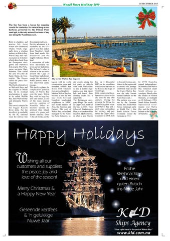
The scenic Walvis Bay Lagoon lagoon with its world conservation status and abundant birdlife that draws bird watchers from across the globe. Modern Walvis Bay has become a hub for two way trade between Namibia's landlocked neighbours in SADC and world markets in Asia, the Americas and Europe. The port of Walvis Bay, owned and managed by the Namibia Ports Authority, to-
day counts among the top ports on Africa's west coast. Walvis Bay is also a marine engineering and ship repair hub and boasts three floating docks and a syncro lift. The Portuguese navigator Diego Cão reached Cape Cross, north of the bay, in 1485. Then followed Bartholomeu Dias, who anchored his flagship, São Cristóvão, in what is now Walvis
Bay on 8 December 1487, on his expedition to discover a sea route to the East via the Cape of Good Hope. Little commercial development occurred on the site until the late 19th century. During the scramble for Africa, the United Kingdom occupied Walvis Bay and a small area surrounding the territory, and permitted the Cape Colony to annex it in 1878, both
to forestall German ambitions in the region and to ensure safe passage of British ships around the Cape (Walvis Bay was the only known natural harbour on the Nami-bian coast.) The enclave was overrun by the Germans before the South-West Africa Campaign early in World War I. But South African Forces eventually ousted the Germans in 1915.
In 1990 Namibia gained independence. as Namibia, but Walvis Bay remained under South African sovereignty. Shortly after the release of Nelson Mandela, at midnight on 28 February 1994, South Africa formally transferred sovereignty over Walvis Bay and the Penguin Islands to the Republic of Namibia.