AXTELL GATEWAY &


Presented by Mike Schlauch, Trent Lister and Valerie Johnson of Platinum Properties, PureWest Chrisitie’s International Real Estate


Contact us today to explore the three buying options we have for these three parcels:
Option #1
Parcels 1 & 2
Offered at $2,200,000
41.62 Acres
MLS# 393261
Option #2
Parcel 3
MLS# 393260
Offered at $4,750,000
157.12 Acres
Option #3
Parcels 1, 2 & 3
MLS# 393276
Offered at $6,950,000
199.54 Acres

Private Well, Shared Septic, Telephone In, 50x60 vintage barn, Fenced pastures for horses, Livestock Permitted
Propane: AmeriGas (Bridger Canyon Co-op)
Internet/TV: StarLink
Home Sound System: Savant (Audio Artisans)
Electricity: Northwestern Energy


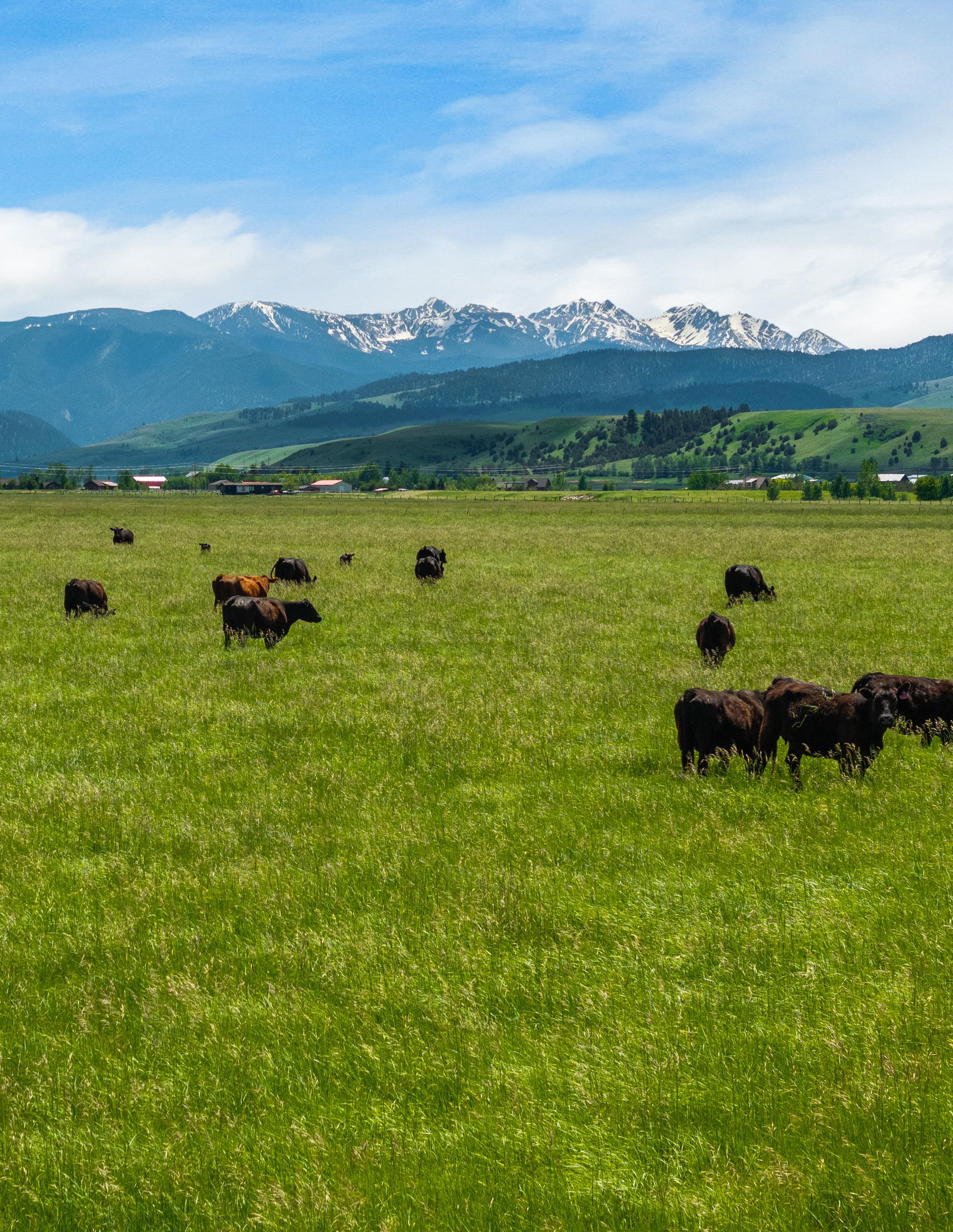
Myriad of opportunities await at this legacy 199+/- acre property in three separate parcels between Bozeman and Big Sky with the breathtaking backdrop of the Spanish Peaks, this unique piece of land offers a rare combination of natural beauty, functional infrastructure, and unparalleled versatility. Enjoy rural living with convenient access to nearby amenities and outdoor recreation, including the Gallatin River.


The property includes a small house currently rented, providing immediate income potential. Several farm buildings are strategically positioned around the house, ready to support your farming or ranching endeavors. Benefit from valuable irrigation water rights and a live spring, ensuring lush, productive land for crops or pasture. The property is fully perimeter and cross-fenced, ideal for managing livestock or creating distinct land use areas. With no zoning restrictions and no covenants, the possibilities for this land are truly limitless.
Whether you envision a dream estate, a thriving agricultural operation, or a thoughtfully planned development, this property can accommodate your vision. The sweeping views of the majestic Spanish Peaks provide a stunning, ever-changing backdrop, enhancing the property’s allure and value. This remarkable property is a rare find, combining the charm of Montana’s countryside with exceptional development potential.


Tax Year: 2024
Scale: 1:12331.02 Basemap: Imagery Hybrid

Property Category: RP
Geocode: 06-0697-03-3-01-30-0000
Primary Owner:
DERHAM FAMILY TRUST
MIKE DERHAM
MILL CREEK, WA 98012-3082
Note: See Owners section for all owners
Certificate of Survey: 3103A
Last Modified: 5/18/2024 7:14:12 AM
Neighborhood: 206.004.B
Subcategory: Agricultural and Timber Properties
Assessment Code: 00RHF12508
Property Address: DEER SPRING LN GALLATIN GATEWAY, MT 59730
Legal Description: S03, T03 S, R04 E, C.O.S. 3103A, PARCEL 1, ACRES 40.423
Property Type: VAC_R - Vacant Land - Rural
Living Units: 0 Levy District: 06-036413-35 13
Zoning: Ownership: 100
LinkedProperty: No linked properties exist for this property
Exemptions: No exemptions exist for this property
Condo Ownership:
General: 0
Topography: n/a
Utilities: n/a
Access: n/a
Location: n/a
Limited: 0
Fronting: n/a
Parking Type: n/a
Parking Quantity: n/a
Parking Proximity: n/a https://svc.mt.gov/msl/cadastral/?page=PropertyDetails&geocode=06-0697-03-3-01-30-0000&taxYear=2024
Tax Year: 2024
No dwellings exist for this parcel
No other buildings exist for this parcel
Commercial
No commercial buildings exist for this parcel
Ag/Forest Land
Ag/Forest Land Item #1
Acre Type: W - Non-Irrigated Hayland
Irrigation Type: n/a Class Code: 1801 Timber Zone: n/a
Productivity
Quantity: 0.5
Commodity: Alfalfa Units: Tons/Acre
Valuation
Acres: 2.403
522
Ag/Forest Land Item #2
Acre Type: W - Non-Irrigated Hayland
Irrigation Type: n/a Class Code: 1801
n/a
Productivity
Quantity: 1.218
Commodity: Alfalfa Units: Tons/Acre
Valuation
Acres: 33.433 Per Acre Value: 529.53 Value: 17704
Tax Year: 2024
Acre Type: W - Non-Irrigated Hayland
Class Code: 1801
Productivity
Quantity: 1.256
Units: Tons/Acre
Valuation
Acres: 4.587
Value: 2505
Irrigation Type: n/a
Timber Zone: n/a
Commodity: Alfalfa
No easements exist for this parcel
The Montana State Library (MSL) provides this product/service for informational purposes only. MSL did not produce it for, nor is it suitable for legal, engineering, or surveying purposes. Data from disparate sources may not be in vertical alignment. Consumers of this information should review or consult the primary data and information sources to ascertain the viability of the information for their purposes. The MSL provides these data in good faith and in no event, shall be liable for any incorrect results or analysis, any lost profits and special, indirect or consequential damages to any party, arising out of or in connection with the use or the inability to use the data or the services provided. The MSL makes these data and services available as a convenience to the public, and for no other purpose. The MSL reserves the right to change or revise published data and/or services at any time.
Tax Year: 2024
Scale: 1:21612.49 Basemap: Imagery Hybrid

Primary Information
Property Category: RP
Geocode: 06-0697-10-2-01-15-0000
Primary Owner:
DERHAM FAMILY TRUST
MIKE DERHAM MILL CREEK, WA 98012-3082
Note: See Owners section for all owners
Certificate of Survey: 3103A
Last Modified: 5/18/2024 7:14:12 AM
General Property Information
Neighborhood: 206.004.B
Subcategory: Agricultural and Timber Properties
Assessment Code: 00RHF12508
Property Address:
Property Type: VAC_R - Vacant Land - Rural
Living Units: 0 Levy District: 06-036413-35 13
Zoning: Ownership: 100
LinkedProperty: No linked properties exist for this property
Exemptions: No exemptions exist for this property
Condo Ownership:
General: 0
Property Factors
Topography: n/a
Utilities: n/a
Access: n/a
Location: n/a
Limited: 0
Fronting: n/a
Parking Type: n/a
Parking Quantity: n/a
Parking Proximity: n/a
Tax Year: 2024
No dwellings exist for this parcel
No other buildings exist for this parcel
Commercial
No commercial buildings exist for this parcel
Ag/Forest Land
Ag/Forest Land Item #1
Acre Type: I - Irrigated
Irrigation Type: n/a Class Code: 1101 Timber Zone: n/a
Productivity
Quantity: 2.28
Commodity: Alfalfa Units: Tons/Acre
Valuation
Acres: 0.485
260
Ag/Forest Land Item #2
Acre Type: I - Irrigated Irrigation Type: n/a
Productivity
Quantity: 4.1 Commodity: Alfalfa Units: Tons/Acre
Valuation
Acres: 0.718 Per Acre Value: 1001.25 Value: 719
Tax Year: 2024
Scale: 1:21858.35 Basemap: Imagery Hybrid

Primary Information
Property Category: RP
Geocode: 06-0697-10-1-01-04-0000
Primary Owner:
DERHAM FAMILY TRUST
MIKE DERHAM MILL CREEK, WA 98012-3082
Note: See Owners section for all owners
Certificate of Survey: 3103A
Last Modified: 5/18/2024 7:14:11 AM
General Property Information
Neighborhood: 206.004.B
Subcategory: Agricultural and Timber Properties
Assessment Code: 00RHF12507
Property Address: 13575 AXTELL GTWAY RD GALLATIN GATEWAY, MT 59730
Legal Description: S10, T03 S, R04 E, C.O.S. 3103A, PARCEL 3, ACRES 157.128
Property Type: FARM_R - Farmstead - Rural
Living Units: 1 Levy District: 06-036413-35 13
Zoning: Ownership: 100
LinkedProperty: No linked properties exist for this property
Exemptions: No exemptions exist for this property
Condo Ownership:
General: 0
Topography: n/a
Utilities: n/a
Access: n/a
Location: n/a
Limited: 0
Fronting: n/a
Parking Type: n/a
Parking Quantity: n/a
Parking Proximity: n/a
Tax Year: 2024
Scale: 1:21858.35 Basemap: Imagery Hybrid
Primary Information
Property Category: RP
Geocode: 06-0697-10-1-01-04-0000
Primary Owner:
DERHAM FAMILY TRUST
MIKE DERHAM MILL CREEK, WA 98012-3082
Note: See Owners section for all owners
Certificate of Survey: 3103A
Last Modified: 5/18/2024 7:14:11 AM
General Property Information
Neighborhood: 206.004.B
Subcategory: Agricultural and Timber Properties
Assessment Code: 00RHF12507
Property Address: 13575 AXTELL GTWAY RD GALLATIN GATEWAY, MT 59730
Legal Description: S10, T03 S, R04 E, C.O.S. 3103A, PARCEL 3, ACRES 157.128
Property Type: FARM_R - Farmstead - Rural Living Units: 1 Levy District: 06-036413-35 13
Zoning: Ownership: 100
LinkedProperty: No linked properties exist for this property
Exemptions: No exemptions exist for this property
Condo Ownership:
General: 0
Property Factors
Topography: n/a
Utilities: n/a
Access: n/a
Location: n/a
Limited: 0
Fronting: n/a
Parking Type: n/a
Parking Quantity: n/a
Parking Proximity: n/a
Deed Information
Tax Year: 2024
Dwelling #1
Dwelling Information Dwelling Type
Residential Type: SFR
- Conventional
08 - Conventional Year Built: 1946
Effective Year: 1975
Type: 1 - Flat Story Height: 1.0 Attic Type: 0 - None
Grade: 4
Class Code: 3110
Exterior Walls: 1 - Frame
Exterior Wall Finish: 6 - Wood Siding or Sheathing Year Remodeled: n/a
Remodeled: n/a
Mobile Home Details Manufacturer: n/a
n/a
n/a
Basement Information
n/a
Foundation: 2 - Concrete Finished Area: n/a
N
Type: 0 - None Quality: n/a
Heating/Cooling Information Type: Central
Living Accomodations
Bedrooms: 4
n/a Addl Fixtures: 3
Additional Information
n/a
& Design: n/a Flat Add: n/a
n/a
Description: n/a
Dwelling Ammenities View: n/a
Tax Year: 2024
Basement: n/a
First Floor: 1511
Half Story: n/a
Attic: n/a
Depreciation Information
CDU: n/a
Desirability
Property: Average (7)
Depreciation Calculation Age: 47
RCNLD: 238260
Additions / Other Features
Addl Floors: n/a
Second Floor: n/a
Unfinished Area: n/a
SFLA: 1511
Physical Condition: Average (7)
Location: Average (7)
No additional features exist for this property
Outbuilding/Yard Improvement #1
Type: Ag Description: AAB2 - Standard Barn
Quantity: 1 Year Built: 1920
Grade: L Condition: Res Fair
Functional: n/a
Dimensions
Width/Diameter: 48 Length: 48
Size/Area: n/a
Bushels: n/a
Outbuilding/Yard Improvement #2
Type:
Quantity: 1 Year Built: 1955
Grade: A Condition: Res Average
Functional: n/a Class Code: 3110
Dimensions
Width/Diameter: n/a
Length: n/a
Size/Area: n/a Height: 11
Bushels: n/a Circumference: 43
Tax Year: 2024
Outbuilding/Yard Improvement #3
Type: Ag Description: AAP1 - Pole Frame Bldg, 4 sides closed, metal
Quantity: 1 Year Built: 1956
Grade: L Condition: Res Fair
Functional: n/a Class Code: 3110
Dimensions
Width/Diameter: 26
Size/Area: n/a
Bushels: n/a
Outbuilding/Yard Improvement #4
Length: 70
Height: n/a
Circumference: n/a
Type: Ag Description: AAG1 - Grain Bins w/o aerator < 60,000 BU
Quantity: 1
Year Built: 1959
Grade: A Condition: Res Average
Functional: n/a Class Code: 3110
Dimensions
Width/Diameter: n/a
Length: n/a
Size/Area: n/a Height: 11
Bushels: n/a
Circumference: 43 Commercial
No commercial buildings exist for this parcel
Ag/Forest Land
Ag/Forest Land Item #1
Acre Type: I - Irrigated
Irrigation Type: n/a Class Code: 1101 Timber Zone: n/a
Productivity
Quantity: 3.04
Commodity: Alfalfa Units: Tons/Acre
Valuation
Acres: 13.899 Per Acre Value: 540.47 Value: 7512
Tax Year: 2024
Ag/Forest Land Item #2
Acre Type: I - Irrigated
Irrigation Type: n/a Class Code: 1101 Timber Zone: n/a
Productivity
Quantity: 4.1
Commodity: Alfalfa Units: Tons/Acre
Valuation
Acres: 6.063
Acre Value: 1001.25 Value: 6071
Ag/Forest Land Item #3
Acre Type: W - Non-Irrigated Hayland Irrigation Type: n/a
Code: 1801
Productivity
Quantity: 0.896
Zone: n/a
Commodity: Alfalfa Units: Tons/Acre
Valuation
Acres: 8.055 Per Acre Value: 389.53 Value: 3138
Ag/Forest Land Item #4
Acre Type: W - Non-Irrigated Hayland
Irrigation Type: n/a Class Code: 1801 Timber Zone: n/a
Productivity
Quantity: 2.35
Commodity: Alfalfa Units: Tons/Acre
Valuation
Acres: 36.758 Per Acre Value: 1021.72 Value: 37556
Ag/Forest Land Item #5
Acre Type: FSA - Farmsite on agricultural land
Irrigation Type: n/a Class Code: 2001 Timber Zone: n/a
Productivity
Quantity: n/a
Commodity: N/A Units: n/a
Valuation
Acres: 1 Per Acre Value: 2003 Value: 2003
Tax Year: 2024
Ag/Forest Land Item #6
Acre Type: G - Grazing
Irrigation Type: n/a Class Code: 1601 Timber Zone: n/a
Productivity
Quantity: 0.205
Commodity: Grazing Fee Units: AUM/Acre
Valuation
Acres: 12.477
Acre
56.56 Value: 706
Ag/Forest Land Item #7
Acre Type: G - Grazing
Irrigation Type: n/a Class Code: 1601
n/a
Productivity
Quantity: 0.255
Commodity: Grazing Fee Units: AUM/Acre
Valuation
Acres: 3.737 Per Acre Value: 70.16 Value: 262
Ag/Forest Land Item #8
Acre Type: G - Grazing
Irrigation Type: n/a Class Code: 1601
Zone: n/a
Productivity
Quantity: 0.355
Commodity: Grazing Fee Units: AUM/Acre
Valuation
Acres: 56.407
Value: 5517
Ag/Forest Land Item #9
Acre Type: G - Grazing
Irrigation Type: n/a Class Code: 1601
Zone: n/a
Productivity
Quantity: 0.367
Commodity: Grazing Fee Units: AUM/Acre
Valuation
Acres: 1.481 Per Acre Value: 101.09 Value: 150
Tax Year: 2024
Acre Type: G - Grazing
Class Code: 1601
Productivity
Quantity: 0.683
Irrigation Type: n/a
Timber Zone: n/a
Commodity: Grazing Fee Units: AUM/Acre
Valuation
Acres: 5.233 Per Acre Value: 188.13 Value: 984
Acre Type: I - Irrigated
Class Code: 1101
Productivity
Quantity: 2.28
Units: Tons/Acre
Valuation
Irrigation Type: n/a
Timber Zone: n/a
Commodity: Alfalfa
Acres: 12.018 Per Acre Value: 535.47 Value: 6435
No easements exist for this parcel
Disclaimer
The Montana State Library (MSL) provides this product/service for informational purposes only. MSL did not produce it for, nor is it suitable for legal, engineering, or surveying purposes. Data from disparate sources may not be in vertical alignment. Consumers of this information should review or consult the primary data and information sources to ascertain the viability of the information for their purposes. The MSL provides these data in good faith and in no event, shall be liable for any incorrect results or analysis, any lost profits and special, indirect or consequential damages to any party, arising out of or in connection with the use or the inability to use the data or the services provided. The MSL makes these data and services available as a convenience to the public, and for no other purpose. The MSL reserves the right to change or revise published data and/or services at any time.


Shopping Cart: 0 items [$0 00]


Property/Parcel TaxID: RHF12508
Status: Current Receipt: 113022
2024 Owner(s): DERHAM FAMILY TRUST
2023 Value:
Market: $21,710 Taxable: $469
Mailing Address: MIKE DERHAM 15207 12TH DR SE
Levy District: 0364-13, 35 G Gateway-GGF-GP


2023 Taxes:


First Half: $79.63 Due: 12/22/2023
Second Half: $87 63 Due: 5/31/2024 Total: $167 26 2023 Payments:

$159 24 (May include penalty & interest)
2023 Legal Records:
Geo Code: 06-0697-03-3-01-30-0000 Deed Book: 156 Page: 4540D Date: 1995-10-02
Property address: DEER SPRING LN, GALLATIN GATEWAY MT 59730
TRS: T03 S, R04 E, Sec 03
Legal: S03, T03 S, R04 E, C O S 3103A, PARCEL 1, ACRES 40 423
Acres: 40.42
COS: 3103A
Geo Code: 06-0697-10-2-01-15-0000 Deed Book: 156 Page: 4540D Date: 1995-10-02
TRS: T03 S, R04 E, Sec 10
Legal: S10, T03 S, R04 E, C O S 3103A, PARCEL 2, ACRES 1.203
Acres: 1 20
COS: 3103A
Note:
If you are having trouble using this search page, please contact our office at 406-582-3033.
If you believe there is an error on the property owner ’s name, geo-code, address, etc.., or have questions regarding your market and/or taxable value,
Shopping Cart: 0 items [$0 00]
Property/Parcel TaxID: RHF12507
Status: Current Receipt: 113021
2024 Owner(s): DERHAM FAMILY TRUST
2023 Value:
Market: $331,864 Taxable: $5,050
2023 Taxes:
Mailing Address: MIKE DERHAM 15207 12TH DR SE MILL CREEK, WA 980123082
Levy District: 0364-13, 35 G Gateway-GGF-GP
First Half: $860.61 Due: 12/22/2023
Second Half: $946.97 Due: 5/31/2024
Total: $1,807.58
2023 Legal Records:
2023 Payments:
First Half: $860.61
Second Half: $946.97 Total: $1,807.58
(May include penalty & interest)
Geo Code: 06-0697-10-1-01-04-0000 Date: 2005-12-28
Property address: 13575 AXTELL GTWAY RD, GALLATIN GATEWAY MT 59730
TRS: T03 S, R04 E, Sec 10
Legal: S10, T03 S, R04 E, C O S 3103A, PARCEL 3, ACRES 157 128
mt gov/detail aspx?taxid=RHF12507


This well log reports the activities of a licensed Montana well driller, serves as the official record of work done within the borehole and casing, and describes the amount of water encountered. This report is compiled electronically from the contents of the Ground Water Information Center (GWIC) database for this site. Acquiring water rights is the well owner's responsibility and is NOT accomplished by the filing of this report.
Site Name: DERHAM FAMILY TRUST
GWIC Id: 245361
DNRC Water Right: 30043304
Section 1: Well Owner(s)
1) DERHAM FAMILY TRUST (MAIL) 1283 N. 14TH AVE, SUITE 201 BOZEMAN MT 59715 [06/10/2008]
2) DERHAM FAMILY TRUST (WELL) 13575 AXTELL GATEWAY GALLATIN GATEWAY MT 59730 [06/10/2008]
Section 2: Location
Township
03S 04E 10 SE¼ SW¼ NE¼ County Geocode
GALLATIN
Latitude
Datum 45 591661 -111 212776 TRS-SEC NAD83 Ground Surface Altitude Ground Surface Method Datum Date
Addition Block Lot
Section 3: Proposed Use of Water DOMESTIC (1)
Section 4: Type of Work
Drilling Method: ROTARY Status: NEW WELL
Section 5: Well Completion Date Date well completed: Tuesday, June 10, 2008
Section 6: Well Construction Details Borehole dimensions From
Completion (Perf/Screen) From To Diameter # of Openings Size of Openings Description 43 93 4 5 3/FT 1/8 INCH DRILLED HOLES
Annular Space (Seal/Grout/Packer)
From To Description Cont Fed? 0 20 BENTONITE Y
Return to menu
Plot this site in State Library Digital Atlas Plot this site in Google Maps
Section 7: Well Test Data
Total Depth: 93
Static Water Level: 4 Water Temperature: Air Test *
20 gpm with drill stem set at 88 feet for 1 hours. Time of recovery 1 hours. Recovery water level 4 feet. Pumping water level feet.
* During the well test the discharge rate shall be as uniform as possible. This rate may or may not be the sustainable yield of the well. Sustainable yield does not include the reservoir of the well casing.
Section 8: Remarks
Section 9: Well Log Geologic Source Unassigned From To Description 0 2 TOPSOIL 2 5 CLAY 5 34 GRAVEL 34 70 SILTY CLAY 70 76 LIMESTONE 76 85 CLAY 85 87 SANDSTONE 87 91 COARSE SAND 91 93 CLAY
Driller Certification
All work performed and reported in this well log is in compliance with the Montana well construction standards. This report is true to the best of my knowledge.
Name: KEVIN HAGGERTY
Company: KEVIN HAGGERTY DRILLING INC
License No: WWC-353
Date Completed: 6/10/2008
DEPARTMENT OF NATURAL RESOURCES AND CONSERVATION
1424 9TH AVENUE P.O. BOX 201601 HELENA, MONTANA 59620-1601
Water Right Number: 41H 103725-00 STATEMENT OF CLAIM Version: 3 -- REEXAMINED
Version Status: ACTIVE
Owners:
GLENNA M DERHAM
%MIKE DERHAM
15207 12TH DR SE MILL CREEK, WA 98012-3082
WILLIAM DERHAM
%MIKE DERHAM
15207 12TH DR SE BOTHELL, WA 98012-3082
Priority Date: JUNE 1, 1877
Enforceable Priority Date: JUNE 1, 1877
Type of Historical Right: DECREED
Purpose (Use): IRRIGATION
Irrigation Type: SPRINKLER/FLOOD
Maximum Flow Rate: 1.08 CFS
Maximum Volume: THE TOTAL VOLUME OF THIS WATER RIGHT SHALL NOT EXCEED THE AMOUNT PUT TO HISTORICAL AND BENEFICIAL USE.
Climatic Area: 4 - MODERATELY LOW
Maximum Acres: 205.00
Source Name: WEST GALLATIN RIVER
Source Type: SURFACE WATER
Point of Diversion and Means of Diversion:
Period of Diversion: MAY 1 TO OCTOBER 1
Diversion Means: HEADGATE
Ditch Name: NOBLE DITCH
Period of Use: MAY 1 to OCTOBER 1
Place of Use:
Geocodes/Valid:
06-0697-03-3-01-01-0000 - Y
06-0697-10-1-01-04-0000 - Y
06-0697-03-3-01-30-0000 - Y
Remarks:
STARTING IN 2008, PERIOD OF DIVERSION WAS ADDED TO MOST CLAIM ABSTRACTS, INCLUDING THIS ONE.
THE WATER RIGHTS LISTED FOLLOWING THIS STATEMENT ARE FILED ON THE SAME FORMERLY DECREED WATER RIGHT. THE SUM OF THE CLAIMED FLOW RATES EXCEEDS THE 43 MINER'S INCHES DECREED IN CASE NO. 3850 , GALLATIN COUNTY. 41H 103725-00, 41H 115525-00, 41H 30115296.
A LATE OBJECTION HAS BEEN FILED TO THE OWNERSHIP, VOLUME, ACRES IRRIGATED, SOURCE AND FLOW RATE OF THIS WATER RIGHT CLAIM. IT WILL BE RESOLVED DURING THE ADJUDICATION OF OBJECTIONS TO THE PRELIMINARY DECREE.
A CLERICAL CORRECTION HAS BEEN MADE TO THE POINT OF DIVERSION . BECAUSE THIS ELEMENT WAS NOT INCLUDED ON THE OBJECTION LIST, ANY WATER USER WHOSE RIGHT MAY BE ADVERSELY AFFECTED BY ENFORCEMENT OF THIS CHANGE MAY PETITION THE APPROPRIATE COURT FOR RELIEF OR MAY FILE AN OBJECTION AT THE PRELIMINARY DECREE.
STATE OF MONTANA
DEPARTMENT OF NATURAL RESOURCES AND CONSERVATION
1424 9TH AVENUE P.O. BOX 201601 HELENA, MONTANA 59620-1601
Water Right Number: 41H 103726-00 STATEMENT OF CLAIM Version: 4 -- POST DECREE
Version Status: ACTIVE
Owners:
GLENNA M DERHAM
%MIKE DERHAM
15207 12TH DR SE
MILL CREEK, WA 98012-3082
WILLIAM DERHAM
%MIKE DERHAM
15207 12TH DR SE
BOTHELL, WA 98012-3082
Priority Date: JUNE 1, 1877
Enforceable Priority Date: JUNE 1, 1877
Type of Historical Right: DECREED
Purpose (Use): IRRIGATION
Irrigation Type: SPRINKLER/FLOOD
Maximum Flow Rate: 1.75 CFS
Maximum
Climatic Area: 4 - MODERATELY LOW
Maximum Acres: 205.00
Source Name: WEST GALLATIN RIVER
Source Type: SURFACE WATER
Point of Diversion and Means of Diversion:
Period of Diversion: MAY 1 TO OCTOBER 1
Diversion Means: HEADGATE
Ditch Name: NOBLE DITCH
Period of Use: MAY 1 to OCTOBER 1
Place of Use:
6 4.50 S2S2NESW 3 3S 4E GALLATIN 7 4.50 W2W2SWSE 3 3S 4E GALLATIN
8 1.00 SWSWNWSE 3 3S 4E GALLATIN Total: 205.00
Geocodes/Valid: 06-0697-03-3-01-01-0000 - Y 06-0697-03-3-01-30-0000 - Y 06-0697-10-1-01-04-0000 - Y
Remarks:
DEPARTMENT OF NATURAL RESOURCES AND CONSERVATION
1424 9TH AVENUE P.O. BOX 201601 HELENA, MONTANA 59620-1601
Water Right Number: 41H 30043304 GROUND WATER CERTIFICATE
Version: 1 -- ORIGINAL RIGHT
Version Status: ACTIVE
Owners:
DERHAM FAMILY TRUST 1283 N 14TH AVE, STE 201 BOZEMAN, MT 59715-3270
Priority Date: AUGUST 14, 2008 at 11:37 A.M.
Enforceable Priority Date: AUGUST 14, 2008 at 11:37 A.M.
Purpose (Use): DOMESTIC LAWN AND GARDEN STOCK
Maximum Flow Rate: 20.00 GPM
Maximum Volume: 3.58 AC-FT
Maximum Acres: 1.00
Source Name: GROUNDWATER
Source Type: GROUNDWATER
Point of Diversion and Means of Diversion:
Period of Diversion: JANUARY 1 TO DECEMBER 31
Diversion Means: WELL
Well Depth: 93.00 FEET
Static Water Level: 4.00 FEET
Casing Diameter: 6.00 INCHES
Well Location: 13575 AXTELL GATEWAY
Purpose (Use): DOMESTIC
Households: 1
Volume: 1.00 AC-FT
Period of Use: JANUARY 1 to DECEMBER 31
Place of Use:
Purpose (Use): LAWN AND GARDEN
Climatic Area: 4 - MODERATELY LOW
Volume: 2.50 AC-FT
Period of Use: APRIL 1 to OCTOBER 31
Place of Use:
Purpose (Use): STOCK
Period of Use: JANUARY 1 to DECEMBER 31
Place of Use:


Countries Cities Sales

The Christie’s International Real Estate network spans nearly 50 countries and territories on six continents. It is the unparalleled expertise of each independently owned Christies International Real Estate Affiliate that truly assures clients of the best representation in any given market. Through a common focus on luxury real estate, strong local ownership, and a dynamic Affiliate network, Christie’s International Real Estate connects buyers and sellers of the world’s preeminent homes.
Christie’s International Real Estate represents the vanguard of luxury real estate, the ultimate in high-end homes and estates. This exclusive invitation-only network includes the world’s premier luxury brokerage firms and the industry’s most accomplished real estate professionals. Across the globe, discerning luxury buyers and sellers trust Christie’s International Real Estate to deliver tailored service and exceptional results.

The Christie’s brand is instantly recognized and immediately distinguishes your home from all others.

Agent | Owner
406.580.8380 | mike@suplatinum.com
Mike, a native Montanan, graduated from Montana State University with a degree in Construction Engineering Technology. The next 13 years were spent working throughout the U.S., managing complex construction projects in several different industries, returning to Montana in 1997. He cofounded Schlauch/Bottcher Construction, Inc. (SBC). As a member of the Platinum team, Mike brings his solid work ethic, extensive construction and business knowledge, along with his love, history, and respect for Montana to all of his clients and transactions.

Platinum Properties Associate | Broker
406.595.0149 | trent@purewestmt.com
A Montana native, Trent has an increasingly rare work ethic and a positive attitude that is contagious. With a passion for serving people and a knack for finding positive solutions, Trent brings a special skill set to his role as a realtor. Constantly driven to provide more value, Trent obtained his Broker license in 2017, is a member of the Realtors Land Institute, the Land Broker Co-Op, and has recently obtained the national title of Accredited Land Consultant. Trent brings integrity, determination, and consistent performance to achieve outstanding results.

Agent | Partner
406.581.5057 | valerie@suplatinum.com
Valerie is a marketing guru with Montana roots. Born in Montana, raised in small town Colorado and returning to the Big Sky State at 16, Valerie deepened her roots in Bozeman after completing her degree in Public Relations/Communications at Carroll College in Helena, MT. She was raised in an entrepreneurial ranching family and knows the meaning of hard work, strong ethics, honesty and relationship-building. Recently married, she is looking forward to raising a family in this beautiful place.

Platinum Properties Associate 406.223.8332 | brett@suplatinum.com
Brett is an entrepreneur, businessman and fifth generation Montanan. Born and raised in Southwest Montana, Brett has an affinity for travel, innovative design, and working with clients on an individual basis to create a custom, expertly crafted home buying experience. He is a restaurant owner, project developer and former published stone mason. He loves old cars, fine wine, his amazing daughter and extraordinary wife. Brett has a passion for Montana real estate, and the authenticity of people who choose to live here.

Platinum Properties Associate 406. 570.3729 | kelley@suplatinum.com
Born and raised in Missoula, Kelley has always known that there is something truly special about Montana. She has been established in the Bozeman market for over 20 years, she truly understands the unique traits and culture that makes each Montana town special. To Kelley, It isn’t just about selling a house, it’s about selling a community and helping you accomplish your family and business goals. Her dedication to customer service and desire to be accessible to every individual she works with makes her an asset in representing both buyers and sellers.

Platinum Properties Associate 406.581.8781 | cristy@suplatinum.com
Christy Delger brings nearly a decade of achievement as a top-producing real estate agent and broker. A Montana native hailing from a small ranching community in the Blackfoot Valley, Christy embodies the core values of hard work, integrity, community connection, and a deep commitment to preserving Montana’s distinctive land resources. In every real estate transaction, she strives to exceed expectations and foster enduring client relationships through attentive listening, thorough understanding of the client’s goals, and unwavering enthusiasm.


