1 minute read
Racial Division Today


LEGEND: WHITE ASIAN HISPANIC
BLACK
Advertisement
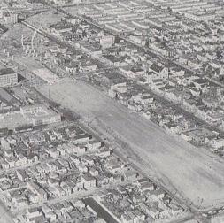
In this final map of the project, I introduce what city planners have done to help remedy the effects caused by mid-century redlining and freeway construction. The major difference would be the removal of the Cyprus Viaduct that carved out rows of West Oakland neighborhood blocks. Now a wide avenue with green space, I should have used a different line type than to visually categorize it with the other MAJOR STREETS on the map. This would have made this major change in the neighborhood easier to highlight on the map.
WEST OAKLAND (1970s)
CYPRUS VIADUCT CONSTRUCTION
WEST OAKLAND (PRESENT DAY)
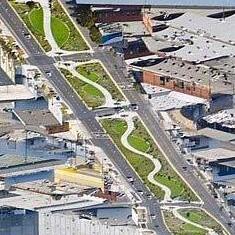
MANDELA PARKWAY (FORMER CYPRUS VIADUCT)
Strengths Weaknesses
- The maps are rich with information.
- The iconography is consistent.
- Some symbols are subjective and not based in actual data.
- Some hatches and line types visually compete with each other.
- Further exercising how to effectively communicate ideas visually through Rhino.
- Exercising how to do preliminary research in the beginning stages of projects.
- Certain hatches and lines may not be visually accessible.
- Finding reliable data and information requires more time.