5 minute read
UN-LANDLOCKING THE INDIAN OCEAN

MUNSTER, Sebastian
Das erst general inhaltend die beschreibung und circtel des gantzen erdtreichs und mores.
Publication
Basel, Heinrich Petri, from 1550.
Description
Double-page woodcut map, with insets of metal type, German text and title within decorative woodcut border attributed to Hans Holbein.
Dimensions
310 by 390mm (12.25 by 15.25 inches).
References Shirley World 92.
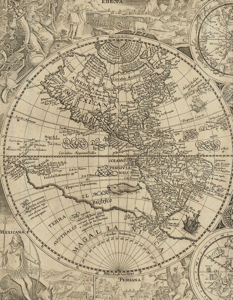
Sebastian Munster’s map of the “modern” world from his ‘Cosmographia’, here reprinting the second woodblock first used in 1550, with the initials of the woodcutter David Kandel appearing in the lower left-hand corner. The titles of the windheads are now in the banners and the east and west winds do not protrude inside the oval circumference. The continents are shown in rough outline only with the Americas taking on an unusual shape, ‘florida’ and ‘francisca’ are almost separated by a deep cleft of water and, further north, the ‘Terra nova sive de Bacalhos’ is part of a huge promontory extending as far as and joining onto Scandanavia.
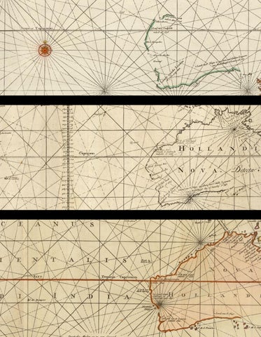
It would appear that Munster’s map is based on a combination of information derived from Verrazzano’s explorations of 1522-24, when the waters of the Chesapeake Bay were mistaken for the Indian Ocean, and reports of Cartier’s voyages of 1534-35 up the St. Lawrence seaway into the Great Lakes vainly searching for the north-west passage. The west coast of North America, hypothetically drawn, carries the name ‘Temistitan’, then generally used to denote Mexico. In Africa, the course of the Nile is prominent, with its twin sources teriminating in a range of mountains. Unidentified islands ‘Grisonum’ and ‘Calensuan’ are placed in the proximity of Australia, while for the first time on a printed map the Pacific Ocean (‘mare pacificum’) receives its name” (Shirley).
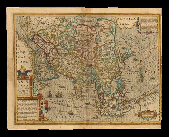
MÜNSTER, Sebastian
Tabula orientalis regionis, Asiae Scilicet extremas complectens terras & regna.
Publication
Basel, Heinrich Petri, 1540.
Description
Double-page woodcut map, with insets of metal type, and fine hand-colour in full, Latin text on verso, small losses to old centrefold.
Dimensions
315 by 410mm (12.5 by 16.25 inches).
References Suarez, ‘Early Mapping of Southeast Asia’, 1999, pages 127-129.
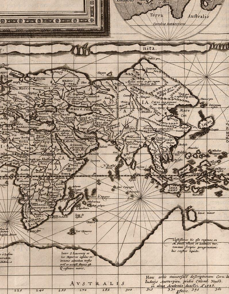
Sebastian Munster’s “rough but fearless” map of all of Asia, from his ‘Geographia universalis, vetus et nova complectens... Succedunt tabulae Ptolemaicae, opera Sebastiani Munsteri novo paratae modo’, the first Latin edition of Münster’s version of Ptolemy, which contained the first “set” of maps of the four continents. This is a Munster’s “modern” map of Asia, having previously provided a map for a 1538 edition of Solinus’s ‘Polyhistory’. It incorporates the latest Portuguese discoveries in the Indian Ocean, as well as Magellan’s crossing of the Pacific. When combined with Munster’s map of America for the same work, it creates one large map extending from the New World to the Far East.
The heading above the map: “Asiae... Extrema”, indicates that the map represents all of Asia beyond the Holy Land and the Middle-east, which here extends eastwards to halfway through the “archipelagous 7448”, or the more than seven thousand islands that Marco Polo thought constituted the Philippines, yet providing the first “cartographic glimpse of any member of the archipelago. “Puloan”, located due north of “Porne” (i.e. Borneo)” (Suarez). For the first time, Sumatra is correctly attributed, Borneo, as “Porne”, appears roughly in the right place and with the right shape, based on Munster’s reading of accounts of Magellan’s voyage. Munster depicts the Moluccas, Timor (“Timos”), Halmahera, and the Malay peninsula, far more clearly than had [Oronce] Fine in 1531, even though he is still hankering for the mythical lands of gold and silver, “Argyre” and “Chryse”. “Iava Minor” and “Iava maior” have been juggled, and there are other anomalies: the map includes a duplication, from its partner of America, of Guram and Rota, as “Insulae pdonu”, or Magellan’s “thieves islands”, and the nomenclature of India and Southeast Asia remains confused.

BORDONE, Benedetto di Java minore [and] Locaz, Necumera, Patera, Botegon, and Mangama.
Publication
Venice, Nicol d’Aristotile detto Zoppino, 1528.
Description
Pair of vignette woodcut maps on a single page, with fine hand-colour in full, Italian text on verso.
Dimensions
Sheet size: 300 by 255mm (11.75 by 10 inches); each: 85 by 145mm.
References
Suarez, ‘Early Mapping of Southeast Asia’, 1999, pages 119-120 .
The uppermost woodcut depicts “Java minore” (i.e. Sumatra), oriented on a north-south axis, “probably following the Cantino model” (Suarez). The lower map depicts a group of named islands: Locaz (i.e. Thailand mistakenly as an island), Necumera, Patera, Botegon, and Mangama. The leaf is from the first Zoppino edition of Benedetto di Bordone’s ‘Isolario…’, the first book printed in Europe to illustrate individual maps of the Southeast Asian islands.
Although Bordone’s cartography of Southeast Asia is rooted in the Metellus framework, “the very fact that he devoted separate maps to the islands represents a symbolic step in Southeast Asian cartography” (Suarez).
Benedetto di Bordone’s ‘Isolario…’, or book of islands, was the first printed atlas of the whole world, combining conventional terrestrial and maritime cartography, the representation of settlements echo maps, and the coastlines are in the style of nautical charts. With a map of the world, it was also an illustrated guide to the islands and peninsulas of the western ocean, the African coastline and the New World, the Mediterranean and lands beyond, including the Aegean archipelago and the Levant, the Indian Ocean and the Far East, with five small maps of Southeast Asian islands. The only other printed isolario to precede it, was the little book of Bartolomeo dalli Sonetti (1485), which included only the Aegean islands.
The isolario, or “book of islands”, was a cartographic form introduced and developed in Italy during the fifteenth and sixteenth centuries. Like the portolano, or pilot-book, to which it was related, it had its origin in the Mediterranean as an illustrated guide for travellers in the Aegean archipelago and the Levant. Bordone’s ‘Isolario’ was the second isolario to be printed and the first to give prominence to the transatlantic discoveries.

RAMUSIO, Giovanni Battista; and Giacomo GASTALDI
Sumatra.
Publication Venice, Stamperia dei Giunta, from 1556.
Description
Double-page woodcut.
Dimensions 290 by 380mm (11.5 by 15 inches).
In an attempt to challenge the successes of Portuguese and Spanish voyages, the French sent several expeditions to the area. A successful expedition from Dieppe had reached the island of Diu in the northern Indian Ocean in 1527. In 1529, the Parmentier brothers Jean and Raoul, also out of Dieppe, ran the Portuguese blockade and reached the Maldive islands. They were able to continue east to the west Sumatran port of Ticon. However, both Parmentier brothers died of fever, and trade with Sumatra was difficult. Only one ship returned to Dieppe, “with far too little in bounty to encourage any further sacrifice of lives or resources” (Suarez) for the French to pursue their ambitions in the region further.
Giacomo Gastaldi’s map of Sumatra, also named Taprobana on the map, was published in the third volume of Giovanni Battista Ramusio’s compendium of voyages, ‘Delle Navigationi et Viaggi’, from 1556. Oriented with south at the top, the map illustrates Ramusio’s account of the Parmentier brothers’, expedition of 1529. Helen Wallis stated: this map as the key to linking transfer of Portuguese cartography school, based on similarity of iconography in their maps to that in this map of Sumatra (‘The Challenge that is an Australian Map’ in ‘The Globe’ 27, 1992, pages 4-9).
“The general contour of the island is remarkably good for its day, and the various islands lying off its western coast are shown in detail, as is Banca on the eastern coast. The port where the Parmentier brothers anchored, Ticon, is recorded, and the manner in which the island’s coast forms a promontory just to the northwest of Ticon is accurately mapped” (Suarez). This is a later issue of the map, with printed page numbers corrected to “433” and “434” (from “430” and “434”) appearing in the top left and top right-hand corners of the map, respectively.