4 minute read
Relationality


Human and the living environment?
The space you are living in?
Advertisement
Where does perception come from and where will it go?
“The Anthropocene” represents a point of view that humanity has affected the earth so profoundly that it has become a formidable geological force has gained considerable ground.
To begin, I would like to introduce the main issues facing the Anthropocene epoch. Carbon emissions will rise as a result of economic and social progress, raising global temperatures. Controlling greenhouse gas emissions has become a big concern for everyone on the planet.
The site of the project is the Azores, the islands are more sensitive and vulnerable due to their isolation and remoteness from the mainland.
For global carbon accounting to remain balanced, peatlands need to function as carbon-capture systems. The peatland distribution of the Azores occupies a large proportion.
I focus on the site of my project from a natural point of view. In peatlands, a unique type of landscape, where human and non-human elements come together to form a “museum of nature”. After studying the site and the surrounding landform fabric, I discovered the role of nature and society in the territory. I therefore see this as two interlocking layers that influence this site.
This is mutually balanced and inseparable. In the Anthropocene epoch, humans are not outsiders to the ecosystem — rather, we are participants in its unfolding.
“Living in the Anthropocene thus necessitates a fundamental shift in understanding relationality as destabilising (rather than as enabling governance as resilience) and thus elicits new non-anthropocentric approaches to knowledge and governance.”
“Relationality was previously understood to extend human knowledge beyond modernist linear and reductionist framings in island resilience. It is now increasingly clear that relationality cannot be contained within these anthropocentric framings.”[1]
After reading some research on land use, I found that it is in the scale of Azores, the area of wetland is decreasing year by year, which is a great threat to the natural environment of the island.
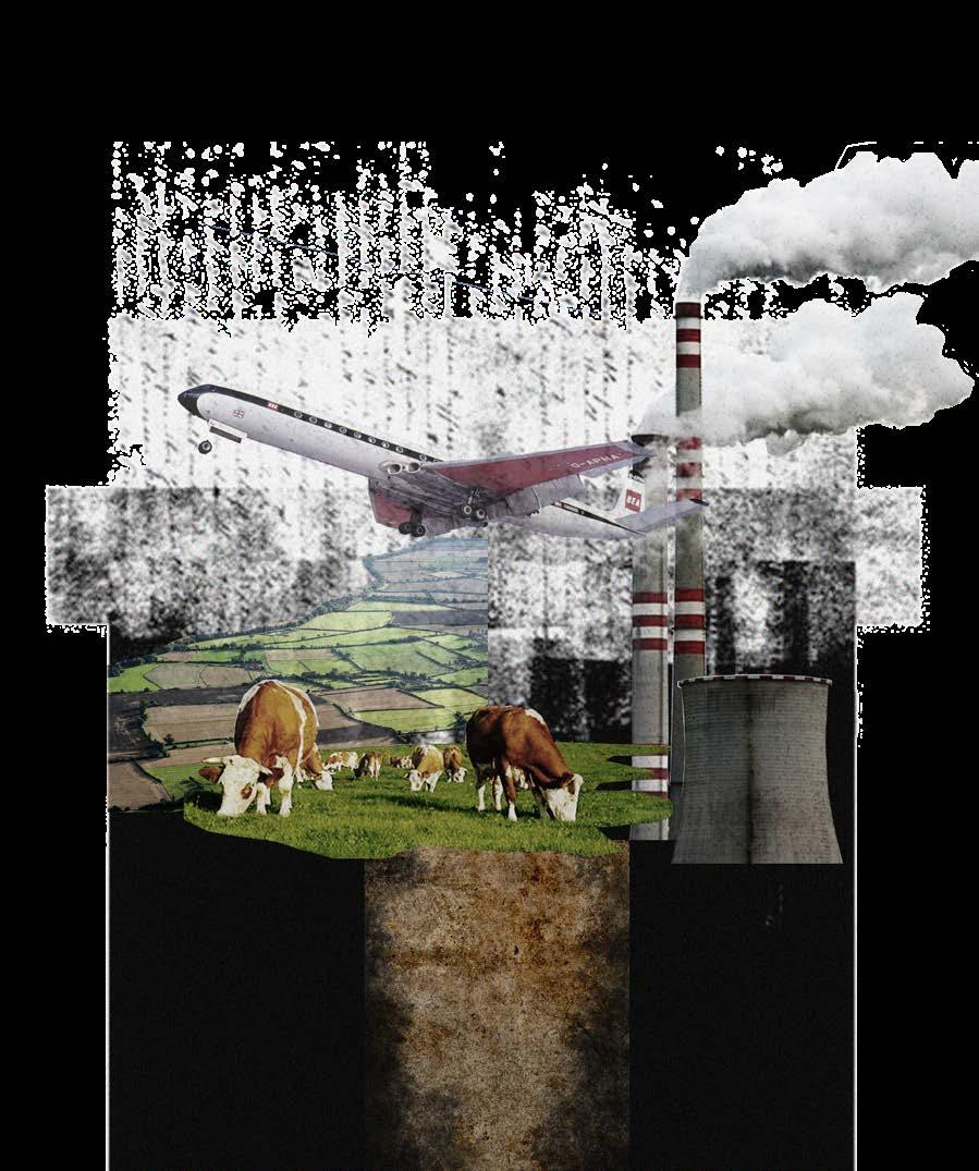
This collage selects elements such as industry, agriculture and animal husbandry, and reflects the impact of human activities on climate change. At the same time, it is a metaphor for the destruction of underground soil carbon storage.
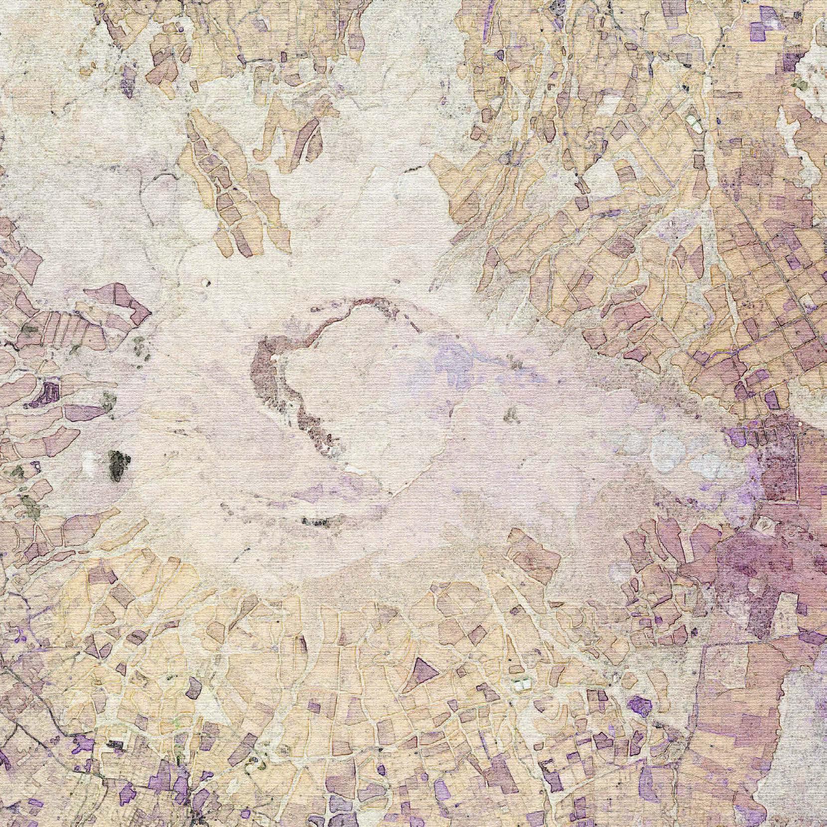
This satellite image has been processed by photoshop to remove specific landscape elements, and more clearly show the texture of the landform in the middle of Terceira Island.

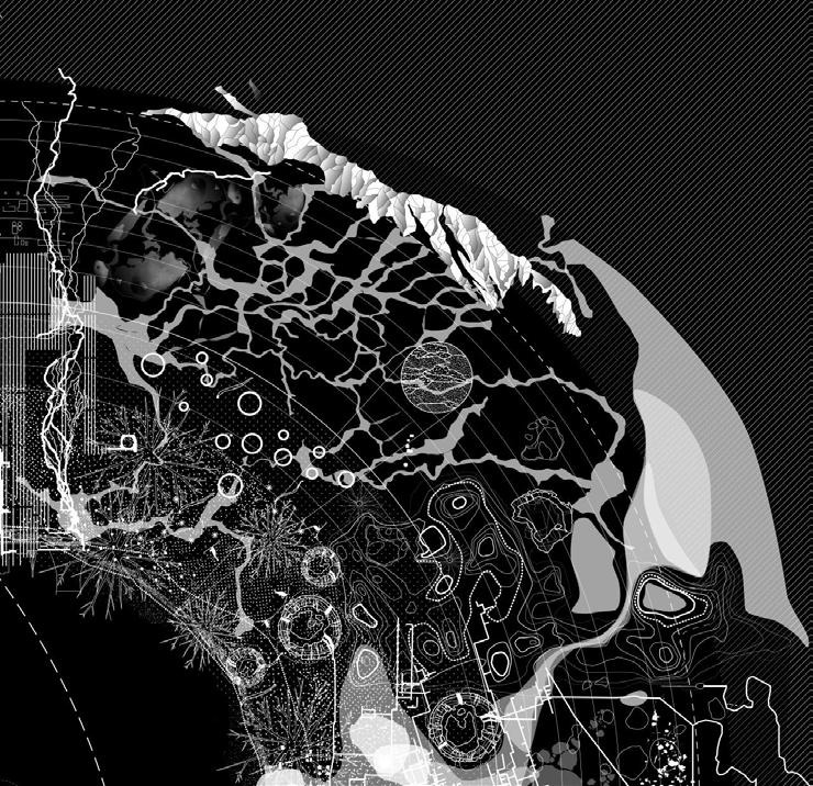
I was primarily inspired by the theory of landscape ecology, focusing on ecological corridors and patches, and prioritizing spatial conservation. The idea of ecology network can be traced to the work of Ian McHarg in the late 1960s and early 1970s, which showed that analysis and assessment of natural resources (geology, soils, water, habitat, etc.) could inform the best places and ways to develop land for social occupation.The way information is superimposed can provide connections between some elements, and plays an important role in interpretation or analysis of landscape at big scale. However McHarg’s work has been identified as lacking consideration of human and culture elements of the landscape.
According to Lefebvre, “on the one hand, space is a product of modes of production, arising from the process of social movement; on the other hand, space is the place where the evolution of social activity takes place, where it can nurture new factors that can change the social process and shape the shape of real society.”[2]
What the landscape describes is also a space, this space contains both naturally formed and socially formed, in Lefebvre’s theory, nature create a space, this space is unique and does not have any purpose, it cannot be called a product. For example, in the Azores, the craters, cinder cones, lavas, etc. formed by volcanic activity. Before the start of human production activities, space is only the trace left by natural time; while society product space, such as rural landscape (Farmland, pasture, afforestation), different urban landscapes, and cities, in purposeful landscapes, people’s social life, behaviours, and memory also change. Landscape can show the influence and feedback of society in natural space.
Relationality is like a transparent line connecting different objects, layers, dimensions.
With regard to the Anthropocene, anthropologists continue to explore underrepresented parts of nature and society.
Bruno Latour focus on the thin surface of the critical zone which is hardly visible at the scale of the typical planetary perspective, being only a few kilometres up and a few kilometres down at most. It’s only a varnish, a thin mat, a film, a bio film. Despite this, it is the only location that living beings have ever visited prior to the discovery and contact with other worlds. It encompasses the entirety of our finite world. We must see it as a skin, the Earth’s skin, sensitive, intricate, ticklish, and reacting. Cells, plants, bugs, creatures, and humans all exist there.[3] This expands my understanding of peatlands from a wetland landscape type to an entire system of zone from subsurface soil to surface organisms.
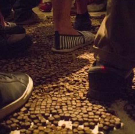
Deep from the surface, soil is a concept with rich meanings. Artists around the globe are using of soil to raise awareness for environmental and social issues, employing earth as an artistic medium for reflection.[4] In one of Lopez’s projects, she gathered and packed this material into one-centimeter-by-one-centimeter cubes, and arranged the cubes on the floor of a room at Havana’s First Alternative Biennial, to be stepped on and blended back to
[4]https://hyperallergic.com/487683/artists-find-common-ground-in-soil-fromaround-the-world/ their original form by passerby. For the landscape field, soil is both the medium and the subject.It can be a problem that needs to be solved, or a tool to shape space, or it can be the storyteller of history.
Draw with charcoal and design different strokes to express different landforms. The basemap processed with digital technology can better feel the difference between different landforms, including the vegetation on the surface, hydrological information, and the structure of artificial areas.


“Since childhood, I have always had a hobby - admiring the peculiar shapes in nature... I mainly like the changes of water, fire, smoke, clouds and floating dust, but there is also something more special , that is, the stains that float and swirl on the eyelids as soon as you close your eyes... No activity can so easily make people discover that they are a creator, and recognize that their minds have been continuously participating in the concrete creation of the world.”
Hermann Hesse