george hascup
01
02
gunho kim: City Permutation advisors:
& arthur ovaska
03 left
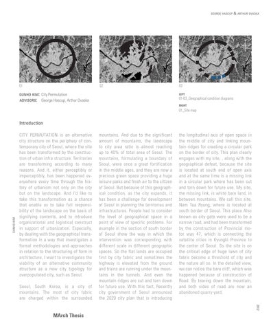
01-03_Geographical condition diagrams
George Hascup, Arthur Ovaska
right
01_Site map
gunho kim
Introduction CITY PERMUTATION is an alternative city structure on the periphery of contemporary city of Seoul, where the site has been transformed by the construction of urban infra structure. Territories are transforming according to many reasons. And it, either perceptibly or imperceptibly, has been happened everywhere every time through the history of urbanism not only on the city but on the landscape. And I’d like to take this transformation as a chance that enable us to take full responsibility of the landscape on the basis of signifying contents, and to introduce organizational and logistical construct in support of urbanization. Especially, by dealing with the geographical transformation in a way that investigates a formal methodologies and approaches in relation to the structuring of form in architecture, I want to investigates the viability of an alternative community structure as a new city typology for overpopulated city, such as Seoul. Seoul, South Korea, is a city of mountains. The most of city fabric are charged within the surrounded
mountains. And due to the significant amount of mountains, the landscape to city area ratio is almost reaching up to 40% of total area of Seoul. The mountains, formulating a boundary of Seoul, were once a great fortification in the middle ages, and they are now a precious green space providing a huge leisure parks and fresh air to the citizen of Seoul. But because of this geographical condition, as the city expands, it has been a challenge for development of Seoul in planning the territories and infrastructures. People had to consider the level of geographical space in a point of view of specific problems. For example in the section of south border of Seoul show the way in which the intervention was corresponding with different scale in different geographic spaces. So the flat lands are occupied first by city fabric and sometimes the highway is elevated from the ground and trains are running under the mountains in the tunnels. And even the mountain ridges are cut and torn down for future use. With this fact, Recently city government of Seoul announced the 2020 city plan that is introducing
the longitudinal axis of open space in the middle of city and linking mountain ridges for creating a circular park on the border of city. This plan clearly engages with my site, , along with the geographical defeat, because the site is located at south end of open axis and at the same time is a missing link in a circular park where has been cut and torn down for future use. My site, the missing link, is white bare land, in between mountains. We call this site, Nam Tea Ryung, where is located at south border of Seoul. This place Also known as city gate were used to be a narrow road, and had been transformed by the construction of Provincial motor way 47, which is connecting the satellite cities in Kyungki Province to the center of Seoul. So the site is on the critical edge of huge lawn of city fabric become a threshold of city and the nature all so. In the detailed view, we can notice the bare cliff, which was happened because of construction of Road. By tearing down the mountain, and both sides of road are now an abandoned quarry yard. 2012
MArch Thesis