
Tyler / Smith County
This plan can be accessed at the following links:
https://www.cityoftyler.org/government/departments/fire-department/emergencymanagement/emergency-management
https://www.smith-county.com/government/departments/emergency-management
PURPOSE
This Cold Weather Response Plan is designed to serve as a guide and to provide helpful information to the public. It includes tips on avoiding exposure and recognizing the signs and symptoms of coldweather-related emergencies. Additionally, it highlights resources available to the public during the winter months, including shelter locations.
RESPONSIBILITY / LEAD AGENCY
The Tyler Fire Department and the Smith County Fire Marshal’s office are the lead agencies for the Cold Weather Response Plan. Agencies or citizens needing information or administrative assistance should call the City of Tyler Fire Department at (903) 535-0005. After hours, or to report hazardous but non-emergency conditions, contact the Tyler Police Department at (903) 531-1000 or the Smith County Sheriff’s Office at (903) 566-6600 For information on public affairs, call the Northeast Texas Public Health District at (903) 535-0020. Call 211 as an additional resource.
……..…ASALWAYS,INANEMERGENCY,PLEASECALL911…….….
SCIENCE - HYPOTHERMIA
When exposed to cold temperatures, the body begins to lose heat faster than it can be produced. Prolonged exposure to cold eventually uses up the body’s stored energy. The result is hypothermia, a condition brought on when the body temperature drops below 90 degrees F. A body temperaturethat is too low affects the brain, making the victim unable to think clearly or move well. This makes hypothermia particularly dangerous because a person may not know it is happening and won’t be able to do anything about it.
Hypothermia is most likely to occur at extremely cold temperatures, but it can also happen at cool temperatures (above 40°F) if a person becomes chilled due to exposure to rain, excessive sweating, or immersion in cold water.
Victims of hypothermia are often:
• older adults with inadequate food, clothing, or heating; a lower metabolic rate might prevent them from maintaining normal body temperatures when temperatures fall below 64.4°F
• Babies sleeping in cold bedrooms.
• People who remain outdoors for long periods - the homeless, hikers, hunters, etc.
• People who drink alcohol or use illicit drugs.
Symptoms of Hypothermia are:
• Uncontrollable shivering
• Slow speech
• Memory lapses
• Frequent stumbling
• Drowsiness
• Exhaustion
From 1991 to 2011, a total of 16,911 deaths in the United States, an average of 1,301 per year, were associated with exposure to excessive natural cold. The highest annual total of hypothermia-related deaths (1,536) was in 2010, and the lowest (1,058) was in 2006. Approximately 67% of hypothermiarelated deaths were among males.
Source: National Vital Statistics System. Mortality public use data files, 1999-2010. Available at QuickStats: Percentage Distribution of Deaths Attributed to Excessive Cold or Hypothermia, by Month United States, 2023 | MMWR
Winter Storm Uri February 13-17, 2021
• 210 people in Texas died because of the historic freeze in February 2021.
• Source: The Texas Department of State Health Services
SCIENCE - FROSTBITE
Frostbiteis an injury caused by freezing. It causes a loss of feeling and color in affected areas. It most often affects the nose, ears, cheeks, chin, fingers, or toes. Frostbite can permanently damage the body, and severe cases can lead to amputation. The risk of frostbite increases in people with reducedblood circulation and those not appropriately dressed for frigid temperatures.
At the first signs of redness or pain in any skin area, get out of the cold or protect any exposed skin where frostbite may begin. Any of the following signs may indicate frostbite:
• A white or grayish-yellow skin area
• Skin that feels unusually firm or waxy
• Pins and needles, followed by numbness
• Red and extremely painful skin and muscle as the area thaws
NOTE: Victims are often unaware of frostbite until someone points it out because frozen tissues are numb in and near the affected area.
TREATMENT
Because frostbite and hypothermia both result from exposure, first determine whether thereare signs of hypothermia, as described previously. Hypothermia is a more serious medical condition and requires immediate emergency medical assistance.
If frostbite or hypothermia is suspected, begin warming the person slowly and seeking immediate medicalhelp.Warmtheperson’strunkfirst. Arms andlegsshouldbewarmedlastbecausestimulating the limbs can cause cold blood to be drawn toward the heart, potentially leading to heart failure. Put the victim in dry clothing and wrap their entire body in a blanket. If no other treatment is available, use your body heat to help raise the victim's core temperature or warm frost-bitten extremities.
Never give a frostbite or hypothermia victim caffeine (coffee or tea). Caffeine, a stimulant, can cause the heart to beat faster and speed up the effects that cold has on the body. Alcohol, a depressant, can slow the heart and speed up the effects of cold body temperature.
If there is frostbite but no sign of hypothermia and immediate medical care is not available, proceed as follows:
• Get into a warm room as soon as possible.
• Unless necessary, do not walk on frostbitten feet or toes, which can increase the damage.
• Immerse the affected area in warm - not hot - water (the temperature should be comfortable to the touch for unaffected body parts).
• Warm the affected area using body heat. The armpit can be used to warm frostbitten fingers.
• Do not rub the frostbite area with snow or massage it. This can cause more damage.
• Do not use a heating pad, heat lamp, or the heat of a stove, fireplace, or radiator for warming. Affected areas are numb and can be quickly burned.
WATCHES, ADVISORIES, AND WARNINGS
Monitor local and national weather channels and stations, and reliable social media. Be alert to changing conditions.
Watch: Issued in the 24 to 72-hour forecast time frame when the risk of a hazardous winter weather event has increased (50to 80%certainty that warning thresholds will bemet). It is intended to provide enough lead time so that those who need to set their plans in motion can do so.
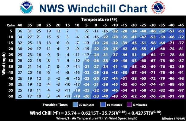
• Wind Chill Watch: Conditions are favorable for wind chill temperatures to meet or exceed local wind chill warning criteria in the next 24 to 72 hours. Wind chill temperatures may reach or exceed -25°F.
• Winter Storm Watch: Conditions are favorable for a winter storm event (heavy sleet, ice
storm, heavy snow, blowing snow, or a combination of events) to meet or exceed local winter storm warning criteria in the next 24 to 72 hours. Criteria for snow is 7” more in 12 hours or less, or 9” or more in 24 hours, covering at least 50% of the zone or encompassing most of the population. Criteria for ice is ½” or more over at least 50% of the zone or encompassing most of the population.
Advisory: Issued when a hazardous winter weather event is occurring, is imminent, or has a high probability of occurrence (generally greater than 80%). An advisory is issued for less severe conditions that cause significant inconvenience and, if not exercised, could lead to situations that may threaten life and/or property.
• Winter Weather Advisory: A winter storm event (sleet, freezing rain, snow, and blowing snow, or a combination of events) is expected to meet or exceed the local winter weather advisory criteria in the next 12 to 36 hours but stay below warning criteria. Criteria for snow is 4" or more in 12 hours, covering at least 50% of the zone or encompassing most of the population.
• Freezing Rain Advisory: Any accumulation of freezing rain is expected in the next 12 to36 hours (but will remain below ½”) for at least 50 percent of the zone or encompassing mostof the population.
• Wind Chill Advisory: Wind chill temperatures are expected to meet or exceed local wind chill advisory criteria in the next 12 to 36 hours. They may reach or exceed -15°F.
Warning: Issued when a hazardous winter weather event is occurring, is imminent, or has a high probability of occurrence (generally greater than 80%). A warning is used for conditions posing a threat to life or property.
• IceStormWarning:Anicestormeventisexpectedtomeetorexceedlocalicestormwarning criteria in the next 12 to 36 hours. Criteria for ice is ½” or more over at least 50 percent of the zone or encompassing most of the population.
• Wind Chill Warning: Wind chill temperatures are expected to meet or exceed local wind chill warning criteria in the next 12 to 36 hours. Wind chill temperatures may reach or exceed -25°F.
• Winter Storm Warning: A winter storm (heavy sleet, ice storm, snow or blowing snow, or a combination of events) is expected to meet or exceed local winter storm warning criteria in the next 12 to 36 hours. Criteria for snow is 7" or more in 12 hours or less, or 9” or more in 24 hours, covering at least 50% of the zone or encompassing most of the population.
PRECAUTIONS
Dressing appropriately is extremely important in preventing cold stress. The type of fabric wornalso makes a difference. Cotton loses its insulation value when it becomes wet. Wool, silk, and most synthetics, on the other hand, retain their insulation even when wet. The following are recommendations for working in cold environments:
• Do not wear tight-fitting clothing.
• Wear at least three layers of loose-fitting clothing. Layering provides better insulation.
o An inner layer of wool, silk, or synthetic material to keep moisture away from the body.
o A middle layer of wool or synthetic material to provide insulation even when wet.
o Outer wind/rain protection layer that allows ventilation to prevent overheating.
• Wear a hat or hood to reduce the amount of body heat that escapes from your head.
• Use a knit mask to cover your face and mouth (if needed).
• Use insulated gloves to protect the hands (water-resistant if necessary).
• Wear insulated and waterproof boots (or protective footwear).
SAFETY TIPS FOR HOME
• Exercise caution when using space heaters.
• Do not heat your home with a gas range, oven, or outdoor cooking appliances.
• Have your heating systems and fireplaces inspected by a licensed professional.
• Do not place a heating device within 3 feet of anything that might catch fire.
• During a power outage, use flashlights rather than candles.
• Use only approved extension cords of sufficient size.
• Exercise caution with Holiday decorations, including trees and candles.
Page | 6
• Install and maintain smoke and carbon monoxide detectors. Change the battery twice a year.
• Do not run a motorized vehicle or generator inside a garage or enclosed building. This could lead to elevated levels of carbon monoxide that could enter your living quarters.
• Insulated walls and attics.
• Caulk and weather strip the doors and windows.
• Install storm windows or cover windows with plastic from the inside.
• Insulate pipes from freezing by wrapping pipes in insulation or layers of old newspapers and wrapping the newspaper with plastic to keep out moisture; let faucets drip a little to avoid freezing; know how to shut off water supply valves; keep proper tools nearby to perform this task.
• Consider acquiring emergency heatingequipment.
• Consider purchasing a generator in case your electrical service is interrupted. Never operate a powered generator inside your home; have qualified personnel connect your generator to your residential power supply.
• Survival techniques may become necessary. Consider alternative sources of water if needed, such as bathroom storage tanks, water heaters, melting snow, filling bathtubs, and other containers.
• Check the batteries inyourflashlights, NOAA WeatherRadio, cell phones, and other portable devices before the storm.
• Assemble a disaster supply kit and make a family communication plan. An emergency kit should include a flashlight, extra batteries, a first aid kit, blankets, and enough food and water for one week per person. Go to Ready.gov for more information
• Prepare a plan and store supplies for the winter months: Important items may include rock salt, sand, shovels, snow shovels, heating fuel, extra clothes, candles, matches, pet supplies, blankets, etc.
SAFETY TIPS FOR WORKERS
• Know the symptoms of cold stress.
• Monitor your physical condition and that of your coworkers.
• Dress appropriately for the cold.
• Stay dry. Moisture and dampness can increase the rate of heat loss from the body.
• Keep extra clothing (including underwear) handy if you get wet and need to change.
• Drink warm, sweetened fluids (no alcohol).
• Use proper engineering controls, safe work practices, and personal protective equipment (PPE) that your employer provides.
SAFETY TIPS FOR TRAVELING
• Maintain a full fuel tank and treat diesel with an anti-gel mixture. If equipped, apply engine
• Check the weather forecast.
• Travel only when necessary and plan long trips carefully.
• Make sure your vehicle is in good operating condition. Winterize your vehicle by checking key components and servicing the cooling and charging systems.
• Replace windshield wiper fluid with a wintertime mixture. Also, keep a windshield scraper and a small broom for snow and ice removal.
• Replace worn tires and check the air pressure. Install winter tires and snow chains as necessary.
• Avoid driving on overpasses and bridges – they often freeze more quickly than roads.
• Carry extra boots, gloves, hats, scarves, and warm clothes.
• Carry a mobile phone, charger, and a backup power supply as needed.
• Listen to the radio or call the Department of Public Safety for the latest road conditions. Whenever possible, travel during daylight hours and bring a companion. If alone, keep others informed of your schedule. Visit https://drivetexas.org/ for additional information.
• Use public transportation when feasible.
• Carry a survival/emergency kit consisting of blankets, a flashlight, extra batteries, a first aid kit, water, high calorie canned or dried foods such as unsalted canned nuts, dried fruit, hard candy, a can opener, and a brightly colored cloth or flagging device or flares.
Go to Ready.gov for more information.
SAFETY TIPS FOR PETS
• If it’s too cold for you, it’s too cold for your pets.
• Bring pets inside when temperatures are dropping.
• If they cannot enter, provide adequate warm, dry, and draft-free shelter.
• Provide access to water that is protected from freezing.
• Provide plenty of high-calorie food.
• Protect pets from exposure to antifreeze. Even small amounts can be deadly.
ACTIONS TO CONSIDER AFTER A WINTER STORM
• Check on family, friends, and neighbors and notify them of your condition.
• Phone lines could be overwhelmed or damaged by the storm. Keep conversations short.
• Monitor local media for the latest information.
• Help people needing special assistance (e.g., the elderly and people with access and functional needs.
| 8 block heaters.
• If you need shelter, call 211, the Salvation Army, American Red Cross, or the fire department non-emergency number, or text SHELTER + your zip code to 4FEMA (43362) to find the nearest shelter.
MEDICAL EVALUATION
Individuals at risk of hypothermia can call 911 for a medical evaluation. Paramedics will respondto identify any problems and provide transport to the appropriate medical facility in the event of an emergency.
SHELTERS
Overnight Locations:
• Salvation Army - 24-hour shelter for the homeless or near-homeless with a capacity of 200. (903) 592-4361. In case of a declared emergency, additional space for 250 is available in the Disaster Shelter
• American Red Cross - Open on demand. Depends on the declared emergency. (903) 581-7981or 1-866-505-4801
Daytime Locations:
• Medical Facilities, including local hospitals, clinics, and stand-alone emergency rooms
• Salvation Army 633 N. Broadway, Open 24 hours, 7 days a week, (903) 592-4361
• Local Fire Stations: Check individual facilities regarding activities and accommodations
• Broadway Square Mall and other retail outlets (On the City bus route)
• Hiway 80 Rescue Mission 601 E. Valentine (903) 617-6097 or (903) 216-9183 8:30am-11:30am and 1:00 p.m. – 4:00 p.m.
• Movie Theatres: Check individual facilities regarding activities and accommodations
• Churches Check with individual facilities regarding activities and accommodations
• Schools. It depends on the declared emergency and whether the school is in session
City of Tyler Facilities
• Tyler Fire Department for available shelter locations. Call 903-535-0005 or 911
• Glass Recreation Center 501 W. 32nd St., Monday through Friday, 7 a.m.-10 p.m., Saturday, 9 a.m.- 3 p.m., closed Sunday. Open to the public during posted hours with an estimated capacity of 500 individuals. Activities can be scheduled by calling (903) 595-7271
• Tyler Public Library 201 S. College. Monday throughThursday,10a.m.-7p.m.;Friday,10a.m.-6 p.m.;Saturday,10a.m.-5p.m.;Sunday,1p.m.-5p.m.Opentothepublicduringpostedhours, with an estimated capacity of 120 individuals. Activities can be scheduled through the library for Taylor Auditorium (capacity 100) by calling (903) 593-7323
• Senior Citizen Activity Center: 1915 Garden Valley Road, (903) 597-0781. For additional information about services, please call 8 a.m. to 5 p.m., Monday through Friday. The estimated capacity is 125.
• Rose Garden 420 Rose Park Drive, (903) 531-1349, 8 a.m.-5 p.m. Monday through Friday, with an estimated capacity of 200.
Warming Centers:
• Several warning centers are available upon demand in the City of Tyler in the event of severe weather.TheseareVOADS (VolunteerOrganizations Activein Disaster)and community centers. Hours vary depending on staffing and availability.
Smith County Day Time Locations:
• Smith County Office of Emergency Management (903) 590-2655
• Smith County ESD #1 (903) 882-3443
• Smith County ESD #2 (903) 617-6578
• Smith County Sheriff’s Office non-emergency (903)566-6600
• 911
TRANSPORTATION:
The following agencies might provide transportation for at-risk individuals to heated shelters or daytime locations. Please contact the individual agency for availability.
• Family, Friends, Neighbors
• Tyler Transit
• UBER – LYFT
• Hospital courtesy vans
• Cab companies
IDENTIFICATION OF ISOLATED/ELDERLY AT-RISK INDIVIDUALS
The following should aim to identify at-risk individuals and connect them to transportation and heating resources. Remember, many people do not have access to a telephone or the internet.
• Family, Friends, Neighbors
• Local Fire Departments
• Police and Sheriff’s Departments (especially beat officers)
• Neighborhood Crime Watch
• Emergency Medical Services (EMS)
• Meals on Wheels
• Senior Citizen Centers
• Emergency Care Centers/Emergency Rooms
• Hospital Social Workers
• Home Health Nurses and Agencies
• Public Health Case Managers/Outreach Workers
• Animal Control Officers
• Church Volunteers
• Citizen Volunteers
• East Texas Council for Independent Living - particularly for disabled residents
WELFARE CONCERN:
Should a concern exist, please get in touch with one of the following:
• Tyler Police and Tyler Fire Department (903) 531-1000 to request a welfare visit
• Smith County Emergency Dispatch / Fire Department and Sheriff’s Office (903) 566-6600
• Lindale Emergency Dispatch / Fire and Police (903) 882-3313
• People with disabilities, including access and functional needs, limited mobility, communication barriers, transportation assistance, personal care, and special medical assistance, should register with the State of Texas Emergency Assistance Register (STEAR)-Public. https://www.dps.texas.gov/dem/stear/public.htm
• If you do not have access to the internet, you can register for STEAR over the phone by dialing 211.
• The City of Tyler Fire Department and the Smith County FMO are the Lead Agency for the State of Texas Emergency Assistance Register (STEAR)-Public within the City of Tyler proper and Smith County.
• Sign up for RAVE alerts. Tyler and Smith County switched from Code Red to Smart 911 and the RAVE Alert system through their partnership with the ETCOG.
o City of Tyler residents: https://www.smart911.com/smart911/registration/registrationLanding.action?cdnExtern a lPath= or click on the link at http://fire.cityoftyler.org and scroll to the bottom of the page
o Smith County residents: https://www.smart911.com/smart911/registration/registrationLanding.action?cdnExtern a lPath= or click on the link at http://smith-county.com/
• FOR EMERGENCIES, CALL 911
PUBLIC AFFAIRS AND MEDIA COMMUNICATIONS:
POWER LINE / TREE LIMB ISSUE
To report electrical / power line issues or tree limb concerns, call:
• Oncor, (888) 313-6862 or http://www.askoncor.com/
• Southwestern Electric Power Company, 888-218-3919 or https://www.swepco.com/outages/
• Cherokee County Electric Cooperative, 903-683-2248 or
http://www.cceca.net/member-services
• Wood County Electric Cooperative, (866) 415-2951 or https://www.wcec.org/about-us/contact-us/
• Upshur County Electric Cooperative, 903-680-2100 or https://urecc.coop/resource-advisory/outage/
HAZARDOUS STREETS
To report hazardous street conditions in the City of Tyler, call (903) 535-1000. In Smith County, call (903) 566-6600
UTILITY ASSISTANCE PROGRAMS:
Individuals with payment issues should contact their utility company to arrange a payment plan if necessary. Agencies that may assist with temporary utility bill assistance include:
• Greater East Texas Community Action Program (GETCAP) (903) 592-3828 or (800) 621-5746 or www.get-cap.org
• PATH Call for information, 903-597-PATH (7284) or visit www.pathhelps.org
• Local Churches Call for information
DONATIONS:
To donate water, blankets, heaters, and transportation services, contact:
• Tyler Fire Department (903) 535-0005
• People Attempting to Help (PATH) (903) 597-4044
• Salvation Army (903) 592-4361
• Meals on Wheels (903) 593-7385
• KLTV Channel 7 (903) 510-7777
• KETK NBC56 (903) 581-5656
• KYTX CBS19 (903) 581-2211
• Smith County ESD #2 and Volunteer Fire Departments (903) 617-6578
• Smith County Office of Emergency Management (903) 590-2655
REPORTING SYSTEMS:
Emergency Rooms and EMS Providers keep records of the number of cold-weather-related injuries and illnesses to monitor the community and inform the development of future cold-weather response Plans. The Texas Department of Health's EMS staff coordinates this.
USERS OF THIS PLAN:
Users of this plan are encouraged to direct questions to the above-identified agencies. If issues are not addressed in the plan or if questions remain unanswered, users should contact the lead agency.
ADDITIONAL INFORMATION
Visit Ready.gov for more information on building your emergency disaster kit and creating a plan for a disaster or emergency.
City of Tyler Emergency Management Coordinator


Smith County FMO
Smith County, Texas