PORTFOLIO ANDREW NETTER
URBAN PLANNING | LANDSCAPE ARCHITECTURE
1210 W. Wayne St., Apt. 206
Muncie, IN 47303
248-946-1040
andrew.netter@bsu.edu
https://www.linkedin.com/in/andrew-netter-337804b3
Masters of Landscape Architecture
Ball State University | Current Student
BS | Urban and Regional Planning
Michigan State University | May 2017
Rhino
AutoCAD
SketchUp
Adobe Photoshop
Adobe InDesign
Adobe Illustrator
ArcGIS Desktop and Pro
ArcGIS Online
ESRI Community Analyst
Hand Drafting
Modeling
Neighborhood Planning
Community Engagement
Microsoft Office
ASSOCIATIONS
College of Architecture and Planning
Graduate Student Organization
Graduate Assistant | August 2022 - Present Ball State University, College of Architecture and Planning | Muncie, Indiana
• Assisting my supervisor with various tasks, including but not limited to: grading papers, conducting research, and developing material for design competitions.
Senior Planner | January 2021 - August 2022
Property Development Analyst | November 2017 - January 2021
City of South Bend, Department of Community Investment | South Bend, Indiana
• Developed a database for all City-owned property and provided on-going upkeep as property is acquired and disposed.
• Remapped zoning districts the entire City for the update and roll-out of the City’s Zoning Ordinance, and created an online interactive map to allow residents to determine their property’s new zoning classification.
• Managed design consultants in the creation of a request for proposals bid package for a portfolio of high profile City properties.
• Led neighborhood planning public meetings and group exercises.
• Worked with consultants on the development of a Vacant Lot Activation Guide for use by neighborhood groups and residents.
• Assisted with the creation of neighborhood plans and organization of public and stakeholder meetings to inform overall strategies outlined in the plans.
• Developed a virtual engagement workshop for residents to use to participate in the creation of a neighborhood plan during the COVID-19 pandemic.
• Provided day-to-day support for City-owned property (directory for all things property related).
• Worked with the various teams throughout the Department of Community Investment to provide GIS/ mapping products and solutions to assist their work.
Transportation Planner | January 2017 - November 2017
Michigan Department of Transportation, Systems Monitoring | Lansing, Michigan
• Provided GIS support for the statewide national highway system network (NHS).
• Conducted GIS processes and statistical analysis of data collected along the NHS.
• Coordinated communication between planning organizations for long-range federal data collection and reporting requirements.
Student Transportation Planning Assistant | August 2015 - May 2017
Michigan Department of Transportation, Statewide Travel Analysis | Lansing, Michigan
• Conducted traffic route assignment for freight transit into, out of, and through Michigan to analyze commodity totals and flows.
• Assisted in traffic count entry and statewide employment data updates for transportation planners to integrate into statewide and urban travel models.
NEAR NORTHWEST NEIGHBORHOOD PLAN PAGE | 6
SOUTH BEND, IN
PROFESSIONAL PROJECT
MIAMI HILLS NEIGHBORHOOD PLAN PAGE | 8
SOUTH BEND, IN PROFESSIONAL PROJECT
WASHINGTON STREET REDESIGN PAGE | 10
SOUTH BEND, IN PROFESSIONAL PROJECT
SHAPING SPACE PAGE | 12
ACADEMIC PROJECT
STRANGE CONTRAPTIONS PAGE | 18
ACADEMIC PROJECT SELECTED ACADEMIC WORK PAGE | 20
The Near Northwest Neighborhood Overall Plan graphic provides a visual representation of all the findings of the planning process. The intention for this graphic is to provide the viewer with a overall visual understanding of the outcome of the plan but more importantly a visual representation of the priorities for the future of the neighborhood.
1. Riverside Dr. redesign and traffic calming and pedestrian network expansion
2. Portage Ave. neighborhood node, Ward Building rehab potential, and 800 block infill potential
3. Leeper Park Riverside Dr. and Lafayette Blvd. intersection calming
4. Sherman Ave. / Harrison Ave. City target area for infill housing with partnership of area nonprofit community development cooperations
5. Downtown South Bend and Memorial Hospital infill development blocks
6. Lincoln Way West and Marion St. City development block opportunity site
7. Portage Ave. neighborhood node and intersection redesign
8. Pedestrian network expansion along Riverside Dr. up to Leeper Park, potential river crossing to the East Bank Trail
9. Muessel School traffic and circulation calming and pedestrian connection improvement to Muessel Grove Park
10. Coal Line Trail project and connection points to the overall neighborhood and expansion of overall pedestrian network


Important Neighborhood Nodes


Important Intersections and Street Sections for Infrastructure Improvements


Future Expansion Routes for Pedestrian Network
Potential River Crossing for Pedestrian Network

Neighborhood Build-out Scenario Based on Market Potential Study
Important Downtown Vacant Lots for Building Development
Near Northwest Neighborhood Plan Boundary


As part of the planning process for the Near Northwest Neighborhood Plan, the City met with representatives from Muessel School to discuss their current operations, future plans, and general observations of the area surrounding the school. From these discussions goals and strategies for action / improvement were developed to address findings:
• The four intersections at the four corners of the school property need to be improved to slow traffic through the school area and increase the safety of students and parents walking to school

• Blaine Ave. within the school block needs to incorporate traffic controls measures to slow traffic and make it easier to parents to dropoff and pick-up students
• Cleveland Ave. within the school block needs to incorporate traffic controls to assist bus drivers during the drop-off and pick-up periods
• The mid-block connection on the east side of the school to staff parking needs to be improved for the safety of staff as they cross Blaine Ave.
• Improve sidewalks and streetscape along California Ave. near the school to improve student access and to contribute to the overall east / west connection for the neighborhood and connection point to the future Coal Line Trail
• Improve sidewalks and streetscape on Vassar Ave. between Muessel Grove Park and Muessel School to create educational opportunities within the park for students and teachers at the school


• Implement traffic controls and pedestrian improvements to create safe crossing for pedestrians and bicyclists using the Coal Line Trail and to slow traffic along Vassar Ave.

The Planning and Community Resources team for the City of South Bend was presented with the unique challenge of having to conduct a planning process in the middle of a worldwide pandemic.
I was tasked with developing a method of engaging the residents of the Miami Hills Neighborhood for meaningful input and feedback for inclusion in the plan. However, it all had to be completed virtually/remotely due to public health and safety.
The Miami Hills Plan Area Public Input


Exercises was modeled off a traditional public input meeting that the City typically uses to engage residents and stakeholders of a plan area at the beginning of a planning process. Participants were guided through three exercises:
• Map My Neighborhood - to identify important places throughout the neighborhood and understand how people moved throughout the neighborhood);

• Areas for Improvement - to identify areas throughout the neighborhood that residents saw needs for improvement; and

• Land Use - to identify areas where zoning could be adjusted to allow for more desired uses and development within the neighborhood to align with the future vision of the area.
As part of the exercises, there was prompting text to get participant thinking about the questions being asked, survey questions, and corresponding interactive maps where participants could directly place pins to explain the input.
The Miami Hills Neighborhood is characterized by regional assets (Erskine Park Golf Course); neighborhood institutions (Monroe Elementary School and Hebrew Orthodox Congregation); stable land use (few vacant lots); a variety of housing types; and proximity to retail/commercial business found in Miami Village and the Erskine Hills Shopping District. While bounded by major streets, there is a lack of east-west connectivity. The area is served by Transpo bus routes, #6 and #8.
The Miami Hills Subdivision is characterized by small (8001000 sq. ft.), single-story homes of fairly uniform design. Streetscapes have sidewalks in good-fair condition but few ADA curb ramps or street trees.


The Miami Hills Apartments opened in 1973 and have 150 units. No major investment in the property has been made recently, and units need to be upgraded or rehabilitated.
Southmore Mutual Housing was created as defense worker housing during World War II and is now a mutually owned housing complex containing 350 units in the form of 2-, 4-, and 6-unit structures.
The Hebrew Orthodox Congregation started in South Bend in 1887 and moved to its current High St. location in 1971. The congregation provides programs and services to Jewish families in South Bend and surrounding area.
Living Stones Church was founded in 2006 and is currently located on Donmoyer Ave. The congregation focuses its community efforts on the south side through partnerships, outreach, and events.
The City of South Bend Erskine Park Golf Course opened to the public for play in 1925 and includes a clubhouse building available for wider community use.
Monroe Elementary School is a public school serving grades kindergarten-5th grade. The public school serves all of the Miami Hills neighborhood.
The following improvement projects, organized by plan goal, are proposed for the Miami Hills Neighborhood:
conditions.
Project – Make Sidewalk Improvements.
- Sections where sidewalks are missing are the highest priority. Curb and handicapped ramps would be included if within the same block. Existing sidewalks in poor condition are the second priority.
Project – Install missing ADA ramps.
Install throughout the neighborhood with a concentration in the Miami Hills subdivision and the highest priority at signalized or other high pedestrian intersections.
Project – Add bus shelters.
- Install at existing stops along TRANSPO routes that utilize Fellows St. Specific locations should be guided by ridership numbers.
2. Goal – Improve safe connections for non-motorized travel both within the neighborhood and to surroundings.
Project – Implement road diets through traffic calmings and intersection improvements.
A Road Diet repositions pavement markings to better meet the needs of all road users. The AADT on Miami St. (10,000-13,000) makes it a good candidate for a road diet in many instances per Federal Highway Association (FHWA) guidelines.
- Miami St. from Donmoyer Ave. to Ireland Rd. –introduce a three lane layout with a single traffic lane in each direction plus a designated center turn lane. This layout serves to reduce vehicle speed; protects left hand turns; and makes pedestrian crossings safer. The remaining space would be dedicated to onstreet bike lanes and a buffer as space allows.
- Fellows St. from Donmoyer Ave. to Chippewa Ave. –stripe parking lanes to visually narrow traffic lanes in order to reduce traffic speed and introduce comfort to traffic lanes.
Intersections within road diet areas – narrow and/ or improve excessively wide intersections either through interim or permanent construction to aid safe pedestrian crossing.
3. Goal – Explore opportunities to introduce park/ recreational space by working with South Bend Venues, Parks, and Arts plus other area institutions and stakeholders.
Project – Since the available land is limited for a potential new park, seek opportunities for a public-private partnership for publicly accessible green space.


Project – Explore a non-motorized trail connection between existing ends of Chippewa Ave. This would allow users to have a safe, convenient east-west travel corridor between Miami St. and Fellows St.
4. Goal – Support the production and maintenance of a range of housing types, including new construction and rehabilitation of market rate and affordable rental housing.
Project – Support efforts to improve Miami Hills Apartments.
- Complete plan process to support a potential application for state funds by property owner.
- Partner with South Bend Code Enforcement to uphold city codes and respond to citizen complaints.
Project – Target the Miami Hills Neighborhood with existing City of South Bend home improvement programs.
5. Goal – Support beautification efforts within the


The Stanley Clark School is an independent coeducational school and serves children preschool-8th grade.
The City's Retention Basin provides storm water management to the broader area.
The O’Brien Recreation Center and Park is a City of South Bend facility open to the public. It includes a fitness center, skate park, and park space.
The Erskine Hills shopping district along Ireland Rd. includes multiple shopping centers (Broadmoor Plaza, Erskine Plaza, and Erskine Village) as well as several restaurants and retail establishments.
Miami Street is characterized by four lanes of high speed traffic with mature street trees located in generous tree lawns. It also has multiple wide intersections, sidewalks either missing or in fair-poor condition. Average annual daily total measures 10,000 13,000 vehicles.
Ireland Road is a four lane, high traffic street that generally lacks sidewalks. In this area the street runs along the southern edge of the of Erskine Park Golf Course and features auto-oritented retail. Average annual daily total measures 17,000 - 19,000 vehicles.
Fellows Street has excessive travel lane widths from Donmoyer Ave. to Chippewa Ave., areas of missing sidewalks, and an oversized Fellows-Chippewa intersection. It includes a portion of Transpo Route 6 (South Michigan/ Erskine Village). A variety of housing types are found along the street.
Donmoyer Avenue has sidewalks in fair to poor condition and includes a portion of Transpo Route 8 (Miami/ Scottsdale). A variety, by age and type, of single-family houses and institutional uses are along the street.
High Street terminates at the Miami Hills Apartment complex and lacks sidewalks in the area. The street contains a signed shared bicycle route between Ridgedale Rd. and Donmoyer Ave.
The feedback received from the public directly informed the creation Understanding the Neighborhood portion of the document. This page serves to outline the existing conditions of the plan area being studied, describe important areas and stakeholders, highlight movement through and around the neighborhood, and highlight areas for opportunity to consider.
From analysis of taking stock of the existing neighborhood conditions, analysis of feedback from the community, and review of area stakeholder interviews, the final Projects page is formed. This page serves to be a broad road map for future City projects, land use and zoning, and spending in the plan area. Emphasis is placed on increasing pedestrian and bicyclist safety and connectivity/access through and around the plan area, right-sizing streets to calm vehicle flows, supporting a range of housing affordability, and neighborhood beautification efforts.


The intersection of Washington St. and Chapin St./Charles Martin Sr. Dr. and the intersection of Washington St. and LaPorte Ave. are two highly traveled and important intersections for the Near West Side Neighborhood. Charles Martin Sr. Dr. and Chapin St. are an important truck route on the west side of downtown. Washington St. is an important street and the main artery for the neighborhood into and out of downtown. Finally, LaPorte Ave. connects the neighborhood to the west side of the City.
As part of the redesign of these intersections complete streets elements were introduced to rightsize the intersection to the surrounding environment. Bump-outs narrowed intersections to force traffic to slow down and to create safer crosswalk areas for pedestrians and bicyclists. Most notably the right-hand turn slip lane on Washington St. to LaPorte Ave. was removed and the intersection was narrowed to slow traffic on LaPorte Ave. and increase pedestrian safety.
1. Excessively wide travel lane widths encourage high speed traffic through the intersection and create dangerous conditions for pedestrians at Washington St. and Chapin St. intersection

2. Tight corner at the southeast corner of Washington St. and Chapin St. create blind spot for drivers and pedestrians traveling west on Washington St.
3. Lane lines are ambiguous for east / west travel on Washington St.
4. Right-hand turn slip lane from Washington St. to LaPorte Ave. allows vehicles to take the corner at high speeds
5. Excessive travel lane widths on LaPorte Ave. create dangerous conditions for pedestrians
6. Parked vehicles on Chapin St., south of Washington St., regularly hit by traffic traveling south on Chapin St.
1. Narrow lane on Chapin St. and Charles Martin Sr. Dr. to slow traffic at intersection
2. Reduce and lane width total lanes from four to two on Washington St. at Chapin St. intersection to reduce vehicle conflict points and slow traffic
3. Introduce bump-outs at all corners of Washington St. and Chapin St. to reduce the distance for pedestrians to cross the streets and increase safety
4. Remove right-hand turn slip lane from Washington St. onto LaPorte Ave.


5. Create a T-style intersection at Washington St. and LaPorte Ave. to force traffic to slow down and reduce the width of the pedestrian crosswalk (increased pedestrian safety)

6. Bump-out at the southwest corner of Washington St. and Chapin St. helps to protect parked vehicles on Chapin St. from traffic coming south
7. Introduce larger tree-lawn ares throughout project area for future street tree planting that can assistant in traffic calming measures
Shaping Space is an effort of interpreting two dimensions into three through a series of sketching, modeling, reproduction, analysis, and representation.


Starting from a two dimensional painting, lines and planes were used to interpret the components of the original painting into a three dimensional reproduction representation. From the initial six models created (three strictly lines, three using lines and planes), sketching, and photographing of the models, two were selected to be expanded upon. Through intensification of the models, repetition of patterns, lines, and curves began to appear through shadows. The photographic studies then serve as the basis for investigation into park concepts. Analysis of existing system lends itself to the exploration of design of a park space. Within the design of the site, utilization of elements of patterns, repetition, and blending of systems between the park and surrounding spaces form a finalized proposal.

Using information gathered from analysis of the site through the project brief and understanding of the surrounding systems, I began to form a series of initial design through sketching. I placed an emphasis on consideration of accessibility into and through the site from the surrounding areas. Using diagrams, I developed an understanding of how the design within the site would interact with the surrounding systems to enhance connectivity through and around the site.


The resulting park design generated from the analysis and preliminary sketches starts exterior to the site. Treatment is given to the intersections and mid-block on the streets directly adjacent to the park space. This provides a means of safe access to the site for pedestrians.
On the canal side, I alter the path along the canal edge by diverting the path up the slope and towards the park space as an intentional directive into the park.
Moving in from the curb, I introduce tree lawn space along the edges to guide pedestrians into the park and encourage use of the space.
Next, within the park space itself, I alter the topography of the site and introduce tree canopies to created a sense of vision through the space to each edge of the park. This provides views from the street edge out to the canal and river, beyond.
Additional elements such as terraced seating mimic the pattern of the topography and provide opportunities for gathering and relaxing. Permeable surface throughout the space allows for ample runoff control.
This section show the western edge of the park and its connection to the canal path. From the canal path, terraced steps lead visitors up into the park. At the top of the canal steps there is a terraced sitting area which allows visitors a view of the canal and river to the west.
The above section elevation faces north looking into the park from, roughly the centerline of South Street. The image depicts the raised/ protected crosswalks that provide safe access to the park space by pedestrians. Th canopy of trees within the park space provide refuge from the streets and traffic and the terraced sitting areas allow for opportunities for gathering and resting.
Perspectives provide insight into how visitors will experience the space. How they enter the park, move through the park, mingle with friends, rest, or relax, recreate, etc.
The top image shows is the perspective of a pedestrian entering the park from the southeastern entrance of the park at the raised intersection of South and East Streets. From this entrance to the space there are opportunities to gather and mingle with others on the terraced sitting area, rest in the grass of the grass of the park lawns, and stroll through the center to the canal.

The bottom images is a view into the park entering from the mid-block raised crosswalk on South Street. From this view, you can see the cut the path creates through the park offering direct access to the courtyard space of the residential buildings.

This project explores methods and techniques of research, measuring, analysis, orthographic drawing, and design through iteration. I examined two devices: a hydration bladder and a garden hose to further investigate and research.


Measured analysis provided a detail interpretation of both objects. Abstraction reduced the information to reveal the defining features of each object. Through diagramming, I define the context of each object, how they are used, what purpose they serve, and essential external components necessary to its function.
In the final iteration I assembled multiple devices into a new strange contraption meant to harvest, control, and convey water. The combination of umbrella’s, 55-gallon drums, pvc piping, ibc totes, a gate valve, and finally a garden hose, the umbrella barrage form the new strange contraption.
Umbrella Barrage combines the following into a system for collecting, controlling, and conveying water: umbrella (flip upsidedown), a 55-gallon barrel, pvc pipe, an ibc tote, a gate valve, and a garden hose. The umbrella is the initial collection device for water. From the umbrella, water is funneled down through the barrel and the network of pvc pipes to the holding space in the ibc tote. From the ibc tote users of the system control the discharge of water through the garden hose by opening and closing the gate valve.
As described above, Umbrella Barrage is a strange contraption with a purpose of collected, controlling, and conveying water through the series of assembled parts.

Units are able to be assembled as standalone structures or can be paired together in a joined system.
In addition to its role with water, units can play a role place-making by providing shade space through the series of umbrellas, thus providing areas for relaxing out of the sun and heat.


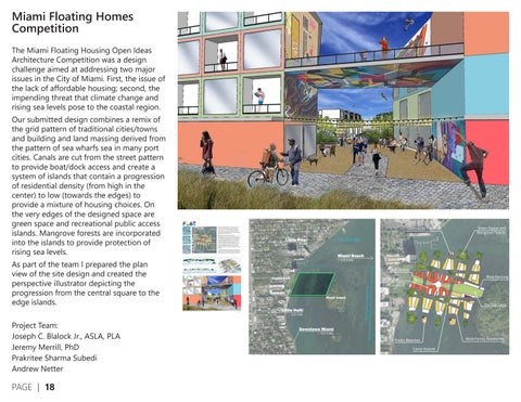
The Miami Floating Housing Open Ideas Architecture Competition was a design challenge aimed at addressing two major issues in the City of Miami. First, the issue of the lack of affordable housing; second, the impending threat that climate change and rising sea levels pose to the coastal region. Our submitted design combines a remix of the grid pattern of traditional cities/towns and building and land massing derived from the pattern of sea wharfs sea in many port cities. Canals are cut from the street pattern to provide boat/dock access and create a system of islands that contain a progression of residential density (from high in the center) to low (towards the edges) to provide a mixture of housing choices. On the very edges of the designed space are green space and recreational public access islands. Mangrove forests are incorporated into the islands to provide protection of rising sea levels.
As part of the team I prepared the plan view of the site design and created the perspective illustrator depicting the progression from the central square to the edge islands.


Project Team:

Joseph C. Blalock Jr., ASLA, PLA
Jeremy Merrill, PhD
Prakritee Sharma Subedi
Andrew Netter
Shapefiles are imported from ArcGIS Pro to Adobe Illustrator to create a basework of geographic information. Then, I use line weights, clipping masks, transparency, and opacities to represent a series of systems throughout the campus.


Ball
AerialBaseMapandCampusBoundary


From an initial basemap sketch, I use the modeling software Rhino to create a 3D representation of the site. Perspective views generated from this model are imported into Adobe Photoshop where I utilize patterns, textures, imagery, and transparency to the illustration. This added entourage provides insight as to the interpreted interaction of pedestrians throughout the space.


Lansing, MI Corridor Challenge
Along Michigan Avenue and Washington Square there are very few instances where businesses are able to utilize the space immediately outside of their buildings due to limited sidewalk frontage and on street parking. My idea is to construct a portable parklet that can be located in on street parking spaces in front of businesses to allow customers to gather, socialize, and utilize the outdoor space. Seating and tables will be provided in an innovative manner and will incorporate greenery and art into the design of the parklet to create an attractive and engaging destination. The installation will provide the opportunity for members and visitors to Lansing to engage and socialize outside while patronizing local businesses. The design of the parklet will allow for easy install and deconstruction and will be easily relocated to new locations throughout the community to ensure that one single entity is benefiting more than others from the attractive community space. It will also offer the opportunity to envision larger areas where the focus in less auto-centric and more centered on providing attractive and quality public spaces for socializing and positive community interaction.


